Embed Size (px)
Citation preview
National Aeronautics andSpace Administration
NASA Marshall Space Flight Center | Core Capabilities and Services
Scientific Research
Earth Science Applying Research to Practical Problems
Marshall’s Earth science capabilities are focused on applying NASA’s Earth observations, models, technologies, and expertise to provide vital data and analyses to offer direct and imme-diate societal benefits. Marshall is NASA’s only field center providing lightning research and applications, is involved in more public health work than any other center, and is the “go-to” center for transitioning Earth science products to operations for researchers, forecasters, and the general public. The Center works closely with key partners, including the University of Alabama in Huntsville, Universities Space Research Association, National Oceanic and Atmospheric Administration (NOAA), National Weather Service (NWS), and Department of Defense — all co-located at the National Space Science and Technology Center (NSSTC).
Marshall’s Earth science specializations include observations of lightning and atmospheric convec-tion, microwave remote sensing, studies of climate dynamics, and efforts aimed at enabling use of NASA observations and modeling capabilities by domestic operational agencies such as NOAA
and the NWS, as well as international agencies, via SERVIR. Lightning research at Marshall also provides operational support for NASA launch activities and NOAA satellite risk reduction and weather warning/prediction.
Field Campaign Research and Planning Support
Field research campaigns are essential for observing and measuring actual Earth system phenomena and validating computer models that simulate Earth systems. Ultimately, field data help improve the nation’s ability to predict climate change and its impacts. Marshall collaborates with the University of Alabama in Huntsville to operate the Global Hydrology Resource Center (GHRC), a designated NASA Data Center for Earth science. The GHRC provides both historical and current Earth science data, information, and products from satellite, airborne, and surface-based instruments. GHRC acquires basic data streams and produces derived products from many instruments spread across a variety of instrument platforms.
At-A-Glance
Marshall Earth science programs and proj-ects follow an applications-driven approach, encompassing international development, public health, weather, and more. When partnering, Marshall focuses on the needs of research and applications end users, and translates NASA Earth observational data into practical solutions.
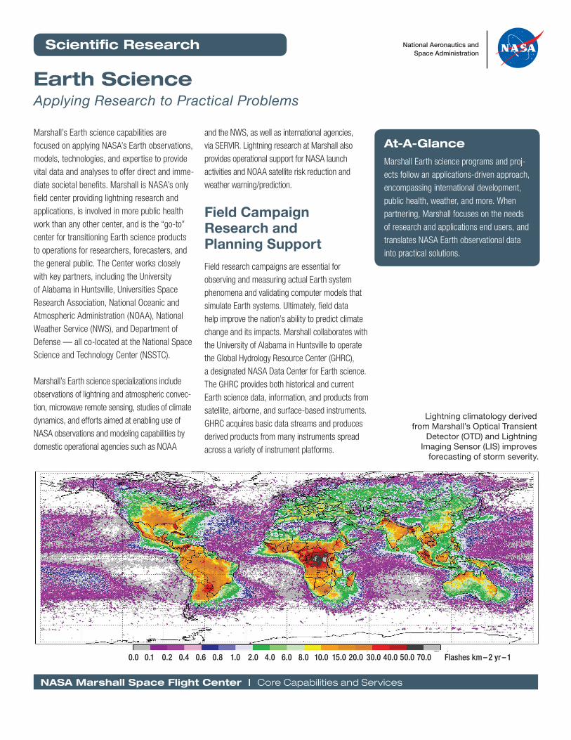
0.0 0.1 0.2 0.4 0.6 0.8 1.0 2.0 4.0 6.0 8.0 10.0 15.0 20.0 30.0 40.0 50.0 70.0 Flashes km – 2 yr – 1
Lightning climatology derived from Marshall’s Optical Transient
Detector (OTD) and Lightning Imaging Sensor (LIS) improves
forecasting of storm severity.
www.nasa.gov/marshallcapabilities
Real-Time Mission Monitor (RTMM)The RTMM is an interactive visualization application that provides situ-ational awareness and science asset management to enable adaptive and strategic decision-making during airborne field experiments. RTMM integrates satellite imagery, radar, surface and airborne instrument data sets, model output parameters, lightning location observations, aircraft navigation data, soundings, and other applicable Earth science data sets. The integration and delivery of this information is made possible through data acquisition systems, network communication links, and network server resources.
Specialty Earth Observing Instruments
Marshall develops an array of specialty Earth observing instruments — ground-based, airborne, and space-borne. The focus of these instrument and technology development projects is on transitioning technologies (both observational and analytical) to further improve operational capabil-ities at the nation’s public health and safety organizations.
Hurricane Imaging Radiometer (HIRAD)HIRAD is the first instrument to produce imagery of ocean wind condi-tions from above a hurricane during the heaviest rain and strong winds, increasing scientists’ ability to predict hurricane storm intensity, structure, and path — potentially saving lives. HIRAD is an innovative technology development that makes unique remotely sensed observations of extreme wind and strong precipitation in oceanic storms. MSFC partnered with NOAA’s Hurricane Research Division (HRD), University of Michigan, and University of Central Florida for both science and engineering efforts, with most of the fabrication and system integration performed at Marshall
Advanced Microwave Precipitation Radiometer (AMPR)AMPR is a cross-track scanning passive microwave radiometer developed and built in cooperation between MSFC and the Georgia Tech Research Institute (GTRI) during the late 1980s to provide measurements of important geophysical parameters from an airborne platform. The instru-ment observes microwave radiation to provide information on surface and atmospheric parameters including precipitation over ocean and land surfaces, ocean surface temperature and near-surface wind speed, soil moisture, and sea ice.
Lightning Imaging Sensor (LIS)Lightning data captured by the Marshall-developed LIS on NASA’s Tropical Rainfall Measuring Mission (TRMM) satellite helps forecasters predict storm severity, enabling forecasters to make critical decisions about whether to issue a warning, and to improve rainfall measure-ments. Marshall is developing other LIS-based products to work with the Geostationary Lightning Mapper (GLM) on NOAA’s next-generation weather satellite — the Geostationary Operational Environmental Satellite-R (GOES-R). In addition to GLM, Marshall is deploying the LIS flight spare to the ISS, to extend the data record and overlap with GOES-R observations. The lightning measurement capability provided by LIS is one of the only earth science measurement capabilities developed by NASA (from technology development to research flight to operations) to be fully operationalized by NOAA.
Earth Science Research to Applications
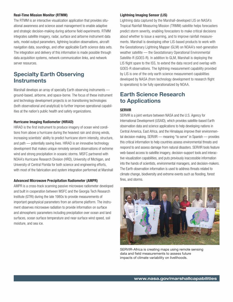
SERVIR SERVIR is a joint venture between NASA and the U.S. Agency for International Development (USAID), which provides satellite-based Earth observation data and science applications to help developing nations in Central America, East Africa, and the Himalayas improve their environmen-tal decision-making. SERVIR — meaning “to serve” in Spanish — provides this critical information to help countries assess environmental threats and respond to and assess damage from natural disasters. SERVIR tools feature web-based access to satellite imagery, decision-support tools and interac-tive visualization capabilities, and puts previously inaccessible information into the hands of scientists, environmental managers, and decision-makers. The Earth observation information is used to address threats related to climate change, biodiversity and extreme events such as flooding, forest fires, and storms.
SERVIR-Africa is creating maps using remote sensing data and field measurements to assess future impacts of climate variability on livelihoods.
NASA Marshall Space Flight Center | Core Capabilities and Services
Short-term Prediction Research and Transition (SPoRT) The Marshall SPoRT Center accelerates the infusion of NASA’s Earth science observations, data assimilation, and modeling research into the regional and local NWS forecasting and decision-making process. SPoRT’s experimental products focus on the regional scale and emphasize forecast improvements on a 0 to 48-hour time scale. This activity complements NOAA’s Joint Center for Satellite Data Assimilation (JCSDA).
SPoRT works closely with the NWS forecasters at 24 local and regional Weather Forecast Offices (WFOs) and five National Centers for Environmental Prediction across the country to identify forecast problems and address them using timely, high-resolution NASA observations and unique research capabilities. The team develops novel data analysis and forecasting techniques and integrates them into a test bed environment to demonstrate their operational feasibility. Promising data and forecast approaches are then integrated into current NWS decision support systems. Weather forecasters are able to easily access and display the gathered observations due to seamless integration with their standard product suite in order to generate weather guidance and advanced forecasts.
SPoRT also works collaboratively with other federal agencies, universities, and private sector partners. In the future, SPoRT will work vigorously to continue its efforts to provide a means for effectively transitioning Earth science observations and research capabilities into NWS and private sector operations, and decision-makers at the regional and local levels. Transitioning emerging experimental data and products into opera-tions through the SPoRT infrastructure will help NASA accelerate this Earth science strategy and move future operational sensors into mainstream operations.
Public HealthThe Marshall Center is involved in more public health work than any other NASA center. Earth scientists collaborate on public health projects with the National Institutes of Health (NIH), NOAA, Center for Disease Control (CDC), and other agencies and academic institutions. Marshall is the principal NASA center for promoting the uses of Earth observations for health and air quality, researching links between cardiovascular diseases and environ-mental factors; modeling pollen release cycles and concentrations to better forecast high-level pollen release and movement; tracking environmental influences such as pollution on childhood asthma; and modeling the spread of infectious diseases spread by mosquitos and ticks.
ACEThe Arctic Collaborative Environment (ACE) project is an international part-nership for information sharing to meet the challenges of addressing the Arctic. The goal of ACE is to create an open source, web-based, multina-tional monitoring, analysis, and visualization decision-support system for Arctic environmental assessment, management, and sustainability. ACE was initiated with funding from the United States government and is managed by Marshall in a joint venture with the Department of Defense through Joint Capability Technology Demonstration funding. ACE provides scientists and educators at partner nations with improved ability to study the Arctic’s response to climate change and to enable project managers and policy implementers better response to a range of issues including transportation and mobility, emergency management, construction of off-shore oil rigs or pipelines, and identification of optimal conditions and routes for Inuit hunting and fishing.
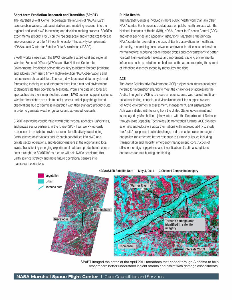
SPoRT imaged the paths of the April 2011 tornadoes that ripped through Alabama to help researchers better understand violent storms and assist with damage assessments.
Tuscaloosa
Warrior River
Vegetation
Urban
Tornado path
Birmingham
Tuscaloosa
Intersate 20/59
Tornado damage area identified in satellite imagery
NASAASTER Satellite Data — May 4, 2011 — 3 Channel Composite Imagery
SERVIR — Using Eyes in the Sky for Societal Benefit
Since its inception in 2004, the SERVIR project has provided assistance to decision-makers in many developing nations to help those leaders address climatological, epidemiological, and ecological issues, by lever-aging the a broad array of existing NASA observational systems and providing critical data in near real-time.
The project, managed at Marshall, opened its first “hub” in Panama in 2005 to serve Central America and the Dominican Republic in cooper-ation with CATHALAC, the Water Center for the Humid Tropics of Latin America and the Caribbean. Additional hubs were opened in 2008 in Nairobi, Kenya, serving all of East Africa, and in 2010 in Kathmandu, Nepal, serving the Kush-Himalaya region. These hubs are partnerships with the Regional Center for Mapping of Resources for Development in Nairobi, and the International Centre for Integrated Mountain Development in Kathmandu, respectively.
Using existing Earth observational systems from NASA and other agencies, SERVIR has been critical in numerous disaster recovery and environmental analysis activities, including:
• Flood and landslide impacts from Tropical Storm Ida in El Salvador (2009)
• Earthquake damage assessment in Port-au-Prince, Haiti (2010)
• Deforestation studies in Belize (2010)
• Flood evaluation in Nicaragua (2010)
• Satellite-based lake monitoring in Guatemala (2010)
• Monsoon flooding analysis in the Khyber Pakhtunkhwa province of Pakistan (2010)
• Fire management system support in Guatemala (2011)
• Drought analysis in the Dominican Republic (2011)
• Detecting red tides in El Salvador (2011)
• Mapping biodiversity in East Africa (2012)
• Forest fire alert system in Nepal (2013)
• Flash flood early warning system in Bangladesh (2013)
• Water resource and water hazard mapping in Bangladesh (2013)
• Malaria risk prediction in Tanzania (2013)
To provide additional observations during disasters and humanitarian crises, the SERVIR team and engineers at Marshall have developed a pathfinder camera system for the International Space Station. This system, the ISS–SERVIR Environmental Research and Visualization System (ISERV), in its first year of operation, has been used to conduct flood damage assessment in Canada. Further instrument development seeks to improve the capabilities of this camera and enable observations in additional wavelengths.
As a joint venture between NASA and USAID, SERVIR relies on those agencies for expertise in scientific research and international develop-ment. Partnerships within the U.S. government include:
• NOAA
• Environmental Protection Agency
• US Forestry Service
• US Geological Survey
Because SERVIR’s long-term goal is to ensure its host nations will one day be self-sustaining, the program works closely with govern-ments and other international organizations to establish local capacity. In addition to 38 national governments, SERVIR works with other entities to perform its mission, including the Kenya Meteorological Department and the United Nations Platform for Space-Based Information for Disaster Management and Emergency Response.
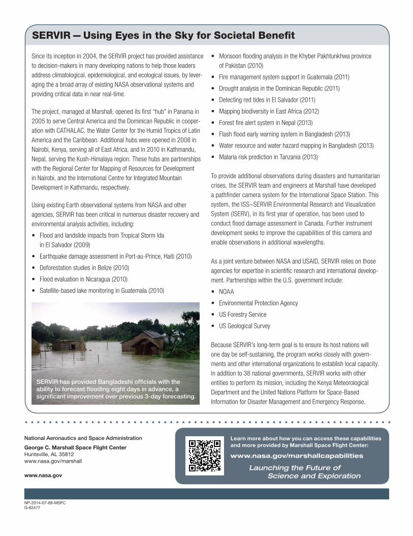
SERVIR has provided Bangladeshi officials with the ability to forecast flooding eight days in advance, a significant improvement over previous 3-day forecasting.
Learn more about how you can access these capabilities and more provided by Marshall Space Flight Center:
www.nasa.gov/marshallcapabilities
Launching the Future of Science and Exploration
National Aeronautics and Space Administration
George C. Marshall Space Flight CenterHuntsville, AL 35812www.nasa.gov/marshall
www.nasa.gov
NP-2014-07-89-MSFCG-62477