Embed Size (px)
Citation preview

ASX and Media Release: 20 November 2013 ASX Code: WRM
Mt Carrington Gold-Silver Project
White Rock Silver Deposit – Resource Upgrade
Indicated Resource of 1.7Mt @ 77g/t Ag for 4.2Moz Ag
Indicated and Inferred Resource of 4.4Mt @ 58g/t Ag for 8.2Moz Ag
White Rock Minerals Limited (ASX:WRM) has completed modelling and Resource estimation to upgrade
the White Rock Ag Resource, one of eight deposits making up the Mt Carrington project. 51% of the
Resource is now classified as Indicated in accordance with the JORC (2004) code. This work was based on
infill drilling completed in July this year, and the upgraded Resource estimate was undertaken by
independent firm Ravensgate Mining Industry Consultants.
The majority of the four largest Au – Ag deposits at the Mt Carrington project are now classified as
Indicated Resources.
White Rock Managing Director Geoffrey Lowe said today: “The upgrade to Indicated Resource for a large
quantity of the White Rock Ag deposit now completes the major geological component in the path to
development of the Mt Carrington gold-silver project. Based on the pit optimisation work from the scoping
study completed in 2012 the proportion of Indicated Resource included in the scoping study approximates
100% for Lady Hampden, 75% for Strauss, 60% for Kylo and 60% for White Rock. On that basis we are happy
that the geological confidence in each deposit will allow us to proceed with feasibility studies in 2014.”
For further information, please contact: Geoffrey Lowe (Managing Director) Andrew Dart (Company Secretary) Phone: 03 5331 4644 E-mail: [email protected] Website: www.whiterockminerals.com.au
Media enquiries to: Simon Jemison C/. Collins Street Media Phone: 03 9224 5319 or 0408 004 848 E-mail: [email protected]
For
per
sona
l use
onl
y

Mineral Resource Estimate – White Rock Silver Deposit
Diamond drilling was completed at White Rock in mid-2013 to upgrade the classification of the previous
JORC (2004) Inferred Resource estimate completed in 2008. Drilling was targeted at the Inferred Resource
within the optimised pit shell based on the Scoping Study completed in 2012. The drilling has provided a
successful outcome with the new global Inferred and Indicated Resource approximately equivalent to the
earlier Inferred Resource in terms of contained metal.
The upgraded global Resource has slightly more tonnes at an overall slightly lower grade than the previous
estimate (4.4Mt @ 58g/t Ag for 8,192,000oz Ag versus 4.1Mt @ 62g/t Ag for 8,194,000oz Ag). The new
Indicated Resource stands at 1.7Mt @ 77g/t Ag for 4,214,000oz Ag, which presents a significantly higher
grade compared to the overall Resource, and represents over 50% of the original Inferred Resource.
Importantly, the drilling completed to upgrade the Resource has resulted in a much more robust
interpretation of the geology, alteration and mineralisation of the White Rock deposit. In addition the core
samples will provide sufficient material to finalise the metallurgical testwork optimisation process during
the feasibility study, as well as enable a precious metal concentrate to be generated for marketing
purposes, an important part of the final feasibility assessment.
The White Rock Ag deposit is located within highly altered rhyolitic to andesitic volcanics, breccias and
volcaniclastics. Mineralisation is low sulphidation epithermal style and occurs within a broad tabular phyllic
alteration zone with stockwork quartz veining, breccia fill and minor massive silicified zones. The bulk of
mineralisation is hosted within felsic intrusive units. The system shows a weak geochemical zonation
towards enriched gold and copper in the southwest in conjunction with stronger alteration. The recognition
of this zonation is considered very encouraging in an exploration sense, as the White Rock deposit environs
has previously been considered to be relatively un-prospective for gold.
Table 1 details the Indicated and Inferred Resource upgrade for the White Rock deposit at a cut-off of 25g/t
Ag with a comparison also presented at a cut-off of 50g/t Ag. Importantly over 60% of the contained silver
reports above the 50g/t Ag cut-off, with over 60% classified as Indicated Resource. The distribution of
higher grade ore provides confidence that the White Rock deposit will form an important part of the
development plans for the Mt Carrington Project.
Table 2 incorporates the new White Rock Resource into the overall Resource base for the Mt Carrington
Project.
The addendum below details the parameters behind the Resource calculation.
For
per
sona
l use
onl
y

Competent Persons Report
The information in this report that relates to Exploration Results or Mineral Resources is based on
information compiled by Mr Rohan Worland who is a Member of the Australian Institute of Geoscientists
and is a full time employee of White Rock Minerals Ltd. Mr Worland has sufficient experience which is
relevant to the style of mineralisation and type of deposit under consideration and to the activity which he
is undertaking to qualify as a Competent Person as defined in the 2004 Edition of the ‘Australasian Code for
Reporting of Exploration Results, Mineral Resources and Ore Reserves’. Mr Worland consents to the
inclusion in the report of the matters based on his information in the form and context in which it appears.
The gold and silver Resource figures for White Rock, Red Rock, Strauss, Kylo, Lady Hampden, Silver King and
White Rock North have been taken from Resource estimates of February 2012, July 2013 and November
2013 prepared by Ravensgate Minerals Industry Consultants on behalf of White Rock Minerals Ltd and
authored by Mr Don Maclean. Mr Maclean is a member and R.P Geo. (Exploration and Mining) of the
Australian Institute of Geoscientists and has sufficient experience relevant to the style of mineralisation and
type of deposit under consideration and to the activity which he has undertaken to qualify as a Competent
Person as defined in the 2004 Edition of the “Australasian Code for Reporting of Exploration Results,
Mineral Resources and Ore Reserves.” Mr Maclean consents to the inclusion in this report of the matters
based on this information in the form and context in which it appears.
The gold and silver Resource figures for Guy Bell have been taken from the resource estimate report dated
1 October 2008 prepared by Mining One Pty Ltd on behalf of Rex Minerals Ltd and authored by Dr Chris
Gee who is a professional geologist with more than 10 years’ experience in resource estimation. Dr Gee is a
Competent Person as defined by the JORC (2004) Code.
WHITE ROCK DEPOSIT November 2013 (JORC 2004) MINERAL RESOURCE
25g/t Ag cut-off
Category Tonnes Silver (g/t) Silver ounces Gold (g/t) Zinc % Lead % Copper %
Indicated 1,705,000 77 4,214,000 0.05 0.68 0.23 0.02
Inferred 2,660,000 47 3,978,000 0.02 0.34 0.10 0.01
Total 4,365,000 58 8,192,000 0.03 0.47 0.15 0.01
50/t Ag cut-off
Category Tonnes Silver (g/t) Silver ounces Gold (g/t) Zinc % Lead % Copper %
Indicated 925,000 112 3,315,000 0.07 0.83 0.29 0.02
Inferred 670,000 88 1,889,000 0.03 0.48 0.15 0.01
Total 1,595,000 102 5,205,000 0.05 0.68 0.23 0.02
Table 1: White Rock Mineral Deposit Resource Estimate Summary November 2013. The estimates have been rounded in accordance with the guidance of the JORC (2004) code.
For
per
sona
l use
onl
y

MT CARRINGTON JORC (2004) MINERAL RESOURCES – NOVEMBER 2013
Silver Dominant Resources
Resource Category Deposit Tonnes Gold grade
(g/t) Gold ounces
Silver grade (g/t)
Silver ounces
Indicated
Lady Hampden 1,840,000 0.6 37,000 69 4,056,000
White Rock 1,710,000 - - 77 4,214,000
Sub-Total 3,550,000 0.3 37,000 72 8,270,000
Inferred
Lady Hampden 2,470,000 0.3 27,000 51 4,023,000
White Rock 2,660,000 - - 47 3,978,000
White Rock North 3,180,000 - - 52 5,314,000
Silver King 640,000 - - 59 1,218,000
Sub-Total 8,950,000 0.1 27,000 51 14,533,000
Total
Lady Hampden 4,310,000 0.5 64,000 58 8,079,000
White Rock 4,370,000 - - 58 8,192,000
White Rock North 3,180,000 - - 52 5,314,000
Silver King 640,000 - - 59 1,218,000
Total 12,500,000 0.2 64,000 57 22,803,000
Gold Dominant Resources
Resource Category Deposit Tonnes Gold grade
(g/t) Gold ounces
Silver grade (g/t)
Silver ounces
Indicated
Strauss 1,240,000 1.4 57,000 3.8 153,000
Kylo 1,590,000 1.2 59,000 2.6 133,000
Sub-Total 2,830,000 1.3 116,000 3.1 286,000
Inferred
Strauss 1,260,000 1.4 56,000 2.6 104,000
Kylo 760,000 1.5 35,000 1.8 43,000
Red Rock 1,630,000 1.0 54,000 3.5 182,000
Guy Bell 160,000 2.5 13,000 4.9 24,000
Sub-Total 3,810,000 1.3 158,000 2.9 353,000
Total
Strauss 2,500,000 1.4 113,000 3.2 257,000
Kylo 2,350,000 1.3 95,000 2.3 176,000
Red Rock 1,630,000 1.0 54,000 3.5 182,000
Guy Bell 160,000 2.5 13,000 4.9 24,000
Total 6,640,000 1.3 275,000 3.0 639,000
Total Resources
Category Tonnes Gold
ounces
Silver ounces
Indicated
6,380,000
153,000
8,556,000
Inferred
12,760,000
185,000
14,886,000
Total
19,140,000
338,000
23,442,000
Table 2: Mt Carrington Mineral Resource Estimate Summary November 2013
All Au-dominant resources have been reported using a lower cut-off of 0.5g/t except Red Rock, which uses a lower cut-off of 0.7g/t. All Ag-dominant resources have been reported using a lower cut-off of 25g/t. The estimates have been rounded in accordance with the guidance of the JORC (2004) code.
For
per
sona
l use
onl
y

Figure 1: Mt Carrington: White Rock Prospect – Location of Indicated and Inferred Resource, current drilling density and historical mine workings.
For
per
sona
l use
onl
y

Addendum Mineral Resource Assessment and Reporting Criteria Summary of Resource Estimate Parameters provided by Ravensgate Mining Industry Consultants
The Mineral Resource estimate for the White Rock Prospect was completed in October 2013 by Corvidae Pty Ltd as
Trustee for Ravensgate Unit Trust Trading as Ravensgate Mining Industry Consultants (‘Ravensgate’) and is reported in
accordance with the JORC (2004) code.
Database Integrity
The Resource is based on 109 exploration holes: 91 RC percussion drillholes completed in the 1980’s by Aberfoyle
and 18 diamond drillholes completed by Rex Minerals and White Rock Minerals (2008-13). Approximately 77% of the
drilling is percussion drilling and 23% is diamond drilling.
RC percussion drillholes are dominantly vertical and have been drilled on spacing’s varying from 15 to 45 metre
centres. All diamond drillholes are angled on nominal 25m spaced northeast-southwest sections. Drillholes were
typically inclined at -60° with both northeast and southwest azimuths used.
All RC percussion and diamond drillholes have downhole survey information.
The relative position of all recent diamond drillhole collars has been surveyed by DGPS methods. Drillhole locations
are considered accurate within 0.5m horizontally and 0.5m vertically. The historic RC percussion holes were accurately
surveyed with respect to a local grid. A recent LiDAR survey has allowed the accurate translation of the local grid holes
such that the holes are considered to be within 3m horizontally and 0.5m vertically.
All diamond drilling was sampled as half core with analysis completed by ALS using 30g fire assay methods for Au
and a multi-acid digestion with HF and ICP finish for Ag, Cu, Pb and Zn. RC percussion holes were assayed by Comlabs
Adelaide. Au was assayed using 30g charge and aqua regia digest. Ag, Cu, Pb and Zn were assayed using AAS with an
HF and HCL digest.
Drillhole data is considered to have adequate QAQC data for the status of the resource (Indicated and Inferred).
Assay data from recent diamond drilling completed by White Rock includes blanks, duplicates and certified standards.
The diamond drillhole samples make up 23% of the composite samples used in the resource estimate. The historic RC
percussion drillholes used in the estimate have QAQC based on a system of duplicate assaying of 5-10% of samples
submitted coupled with blind re-assays of selected higher grade Ag (>20g/t Ag) material. Umpire assaying of a small
package of samples (38) was also completed. Comparison of the White Rock diamond drill samples to the historic RC
percussion samples shows generally similar sample populations and that mineralised intercepts have similar and
consistent spatial locations. In Ravensgate’s opinion it is reasonable to use the historic RC percussion drillholes in the
estimate.
Geological interpretation
The Resource is located within altered rhyolitic to andesitic volcanics and volcaniclastics of the Permian Drake
Volcanics. Mineralisation is low sulphidation epithermal silver-rich with variably associated gold and minor base
metals including zinc and copper.
Mineralisation occurs within a broad tabular phyllic alteration zone with sheeted to stockwork style silica veining,
breccia fill and minor massive silicified zones.
The strike length of the resource is approximately 400m comprised of one main northeast striking gently south east
dipping body.
For
per
sona
l use
onl
y
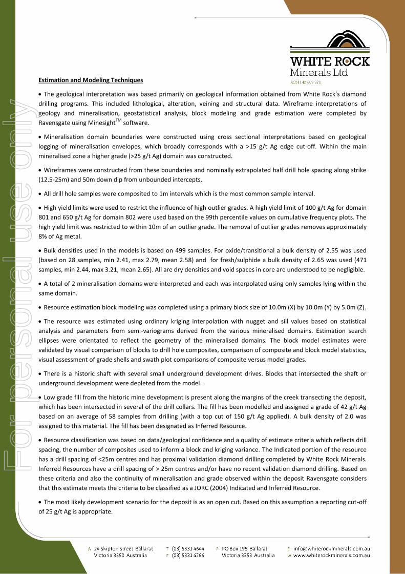
Estimation and Modeling Techniques
The geological interpretation was based primarily on geological information obtained from White Rock’s diamond
drilling programs. This included lithological, alteration, veining and structural data. Wireframe interpretations of
geology and mineralisation, geostatistical analysis, block modeling and grade estimation were completed by
Ravensgate using MinesightTM
software.
Mineralisation domain boundaries were constructed using cross sectional interpretations based on geological
logging of mineralisation envelopes, which broadly corresponds with a >15 g/t Ag edge cut-off. Within the main
mineralised zone a higher grade (>25 g/t Ag) domain was constructed.
Wireframes were constructed from these boundaries and nominally extrapolated half drill hole spacing along strike
(12.5-25m) and 50m down dip from unbounded intercepts.
All drill hole samples were composited to 1m intervals which is the most common sample interval.
High yield limits were used to restrict the influence of high outlier grades. A high yield limit of 100 g/t Ag for domain
801 and 650 g/t Ag for domain 802 were used based on the 99th percentile values on cumulative frequency plots. The
high yield limit was restricted to within 10m of an outlier grade. The removal of outlier grades removes approximately
8% of Ag metal.
Bulk densities used in the models is based on 499 samples. For oxide/transitional a bulk density of 2.55 was used
(based on 28 samples, min 2.41, max 2.79, mean 2.58) and for fresh/sulphide a bulk density of 2.65 was used (471
samples, min 2.44, max 3.21, mean 2.65). All are dry densities and void spaces in core are understood to be negligible.
A total of 2 mineralisation domains were interpreted and each was interpolated using only samples lying within the
same domain.
Resource estimation block modeling was completed using a primary block size of 10.0m (X) by 10.0m (Y) by 5.0m (Z).
The resource was estimated using ordinary kriging interpolation with nugget and sill values based on statistical
analysis and parameters from semi-variograms derived from the various mineralised domains. Estimation search
ellipses were orientated to reflect the geometry of the mineralised domains. The block model estimates were
validated by visual comparison of blocks to drill hole composites, comparison of composite and block model statistics,
visual assessment of grade shells and swath plot comparisons of composite versus model grades.
There is a historic shaft with several small underground development drives. Blocks that intersected the shaft or
underground development were depleted from the model.
Low grade fill from the historic mine development is present along the margins of the creek transecting the deposit,
which has been intersected in several of the drill collars. The fill has been modelled and assigned a grade of 42 g/t Ag
based on an average of 58 samples from drilling (with a top cut of 150 g/t Ag applied). A bulk density of 2.0 was
assigned to this material. The fill has been designated as Inferred Resource.
Resource classification was based on data/geological confidence and a quality of estimate criteria which reflects drill
spacing, the number of composites used to inform a block and kriging variance. The Indicated portion of the resource
has a drill spacing of <25m centres and has proximal validation diamond drilling completed by White Rock Minerals.
Inferred Resources have a drill spacing of > 25m centres and/or have no recent validation diamond drilling. Based on
these criteria and also the continuity of mineralisation and grade observed within the deposit Ravensgate considers
that this estimate meets the criteria to be classified as a JORC (2004) Indicated and Inferred Resource.
The most likely development scenario for the deposit is as an open cut. Based on this assumption a reporting cut-off
of 25 g/t Ag is appropriate.
For
per
sona
l use
onl
y

About White Rock Minerals
White Rock is an Australian minerals exploration company focussed on the discovery and development of shallow gold, silver and copper deposits in the New England Fold Belt, northern NSW. The Company is targeting deposit styles similar to those at Cracow, Mt Rawdon and Mt Carlton.
White Rock’s cornerstone asset is the 100% owned Mt Carrington project where shallow Indicated and Inferred Mineral Resources totalling 338,000oz gold and 23.5Moz silver have been defined. Exploration drilling at Mt Carrington is in progress with the aim of extending the shallow Resource base, and to test a number of prospective regional and near-mine targets within a tenement area of 600km
2 over the under-explored Drake Volcanics.
Market Capitalisation: A$7m @ A$0.04/share Issued Capital: 184m Ordinary shares, 9.9m Unlisted options (September 2013) Balance Sheet: $4.3M, no debt (September 2013) Shareholders Avalon Ventures Corporation 43.47%
Greenstone Property Pty Ltd 9.81%
Silverstone Investment Holdings Pty Ltd 3.68%
Board and Management 2.60%
Grand South Development Ltd 1.65%
TOP 20 69%
Board and Management Brian Phillips - Non-Executive Chairman
Geoffrey Lowe - Managing Director
Steven Olsen - Non-Executive Director
Peter Lester - Non-Executive Director
Andrew Dart - CFO & Company Secretary
Rohan Worland - Exploration Manager
About Mt Carrington, New South Wales
Location: Mt Carrington is 5 km from the township of Drake in northern NSW. It is located on the Bruxner Highways 4 hour’s drive SW of Brisbane and 2 hours west from Ballina.
History: Gold was first discovered in the district in 1853 with a number of
small prospects worked over the next 25 years. In 1886 gold and silver were found at Drake, Mt Carrington, White Rock and Red Rock. Prospecting and small-scale mining continued into the 1920s. During 1974 to 1976 Mt Carrington Mines Ltd extracted a small tonnage of high grade Ag and Au from the Lady Hampden open pit. In 1988 a new mining campaign focussed on extracting open pit oxide Au/Ag ore from the Strauss, Kylo, Guy Bell and Lady Hampden deposits. The oxide ore was depleted by 1990, and with metal prices at US$370/oz Au and US$5/oz Ag, and secondary copper zones in the pits resulting in processing issues in the CIP plant, the small scale mine was closed.
The new Mt Carrington: In April 2008 Rex Minerals Ltd acquired Mt Carrington and completed 2 years of exploration and Resource definition. The project was demerged in June 2010 with the formation of White Rock Minerals to undertake extensive exploration, Resource definition and development studies with the aim of defining a new viable open pit mining operation, underpinned by existing Mining Lease tenure, site infrastructure, and ready access to power and water.
For
per
sona
l use
onl
y

Volcanic Caldera: In the early 1990s CRA Exploration focused on exploring for ‘a large polymetallic mineralised system in a Pacific Rim-type environment’. Detailed mapping and reconstruction of the volcanic architecture was undertaken by White Rock in 2011-2012, which established a large 400 square km collapsed volcanic caldera structure. This setting has been demonstrated to contain a number of epithermal-style precious metal targets, many of which will be drill tested in 2013. Up to 2010 no systematic regional exploration had been undertaken on the project for more than 16 years.
Scoping Study: In July 2012 White Rock completed a high level Scoping Study which demonstrated the viability of a low-capex, robustly economic, 40,000ozpa gold/silver project. White Rock proposes to undertake feasibility studies to progress and define the development options outlined in the Scoping Study.
Resources: In February 2012 an upgraded and updated Resource estimate was published, with a total of 0.28Moz Au and 23.3Moz Ag at the Kylo, Strauss, Lady Hampden, Silver King, White Rock and White Rock North deposits. For more detail refer to WRM’s announcement to the ASX of 13 February 2012. In July 2013 a maiden Resource estimate for Red Rock was published. For more detail refer to WRM’s announcement to the ASX of 11 July 2013. The updated Resource estimate for all deposits at the Mt Carrington Project totals 0.34Moz Au and 23.5Moz Ag.
MT CARRINGTON JORC (2004) INDICATED & INFERRED MINERAL RESOURCE SUMMARY
Deposits Tonnes Au (g/t) Gold Oz Ag (g/t) Silver Oz
Gold Dominant 6,640,000 1.3 275,000 3.0 639,000
Silver Dominant 12,500,000 0.2 64,000 57 22,803,000
Total Resources Indicated 6,380,000
153,000
8,556,000
Inferred 12,760,000
185,000
14,886,000
Total 19,140,000
338,000
23,442,000
*Competent Persons Report
The information in this report that relates to Exploration Results or Mineral Resources is based on information compiled by Mr Rohan Worland who is a Member of the Australian Institute of Geoscientists and is a full time employee of White Rock Minerals Ltd. Mr Worland has sufficient experience which is relevant to the style of mineralisation and type of deposit under consideration and to the activity which he is undertaking to qualify as a Competent Person as defined in the 2004 Edition of the ‘Australasian Code for Reporting of Exploration Results, Mineral Resources and Ore Reserves’. Mr Worland consents to the inclusion in the report of the matters based on his information in the form and context in which it appears. The gold and silver Resource figures for White Rock, Strauss, Kylo, Lady Hampden, Silver King and White Rock North have been taken from the resource estimate prepared by Ravensgate Minerals Industry Consultants on behalf of White Rock Minerals Ltd and authored by Mr Don Maclean. Mr Maclean is a member of the Australian Institute of Geoscientists and has sufficient experience relevant to the style of mineralisation and type of deposit under consideration and to the activity which he has undertaken to qualify as a Competent Person as defined in the 2004 Edition of the “Australasian Code for Reporting of Exploration Results, Mineral Resources and Ore Reserves.” Mr Maclean consents to the inclusion in this report of the matters based on this information in the form and context in which it appears. The gold and silver Resource figures for Guy Bell have been taken from the resource estimate report dated 1 October 2008 prepared by Mining One Pty Ltd on behalf of Rex Minerals Ltd and authored by Dr Chris Gee who is a professional geologist with more than 10 years’ experience in resource estimation. Dr Gee is a Competent Person as defined by the JORC Code. Mr Gee consents to the inclusion in this report of the matters based on this information in the form and context in which it appears
For
per
sona
l use
onl
y

Location of the Mt Carrington exploration and mining tenements with gold and silver Resources
For
per
sona
l use
onl
y