Embed Size (px)
Citation preview
www.hikingupward.com
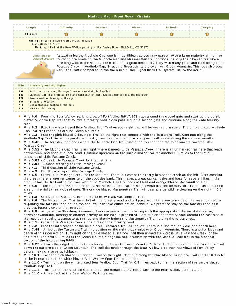
Mudhole Gap - Front Royal, Virginia
Length Difficulty Streams Views Solitude Camping
11.6 mls
Hiking Time:Elev. Gain:
Parking:
5.5 hours with a break for lunch1,740 ft Park at the Bear Wallow parking on Fort Valley Road. 38.92421, -78.33275
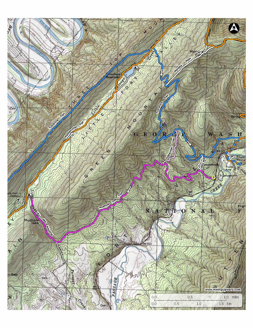
At 11.6 miles the Mudhole Gap loop isn't as difficult as you may expect. With a large majority of the hikefollowing fire roads on the Mudhole Gap and Massanutten trail portions the loop the hike can feel like anice long walk in the woods. The circuit has a good deal of diversity with many pools and runs along LittlePassage Creek in Mudhole Gap, Strasburg Reservoir, and views from Green Mountain. This loop also seesvery little traffic compared to the the much busier Signal Knob trail system just to the north.
Mile Summary and Highlights
3.64.54.96.97.49.3
Walk upstream along Passage Creek on the Mudhole Gap TrailMudhole Gap Trail ends at FR66 and Massanutten Trail. Multiple campsites along the creekPass a wildlife clearing on the rightStrasburg ReservoirBegin steepest section of the hikeViews of Fort Valley
Mile 0.0 - From the Bear Wallow parking area off Fort Valley Rd/VA 678 pass around the closed gate and start up the purpleblazed Mudhole Gap Trail that follows a forestry road. Soon pass around a second gate and continue along the wide forestryroad.Mile 0.2 - Pass the white blazed Bear Wallow Spur Trail on your right that will be your return route. The purple blazed MudholeGap Trail trail continues around Green Mountain.Mile 1.3 - Pass the pink blazed Sidewinder Trail on the right that connects with the Tuscarora Trail. Continue along theMudhole Gap Trail. From this point the forestry road can become more overgrown with grass during the summer months.Mile 3.45 - The forestry road ends where the Mudhole Gap Trail enters the treeline then starts downward towards LittlePassage Creek.Mile 3.52 - The Mudhole Gap Trail turns right where it meets Little Passage Creek. There is an unmarked trail here that leadsdownstream and ends at a local road. Continue upstream on the purple blazed trail for another 0.3 miles to the first of 5crossings of Little Passage Creek.Mile 3.82 - Cross Little Passage Creek for the first time.Mile 3.94 - Second crossing of Little Passage Creek.Mile 4.1 - Third crossing of Little Passage Creek.Mile 4.3 - Fourth crossing of Little Passage Creek.Mile 4.5 - Cross Little Passage Creek for the 5th time. There is a campsite directly beside the creek on the left. After crossingthe creek there is another campsite on the opposite bank. This makes a great car campsite and base for several hikes in thearea. Follow the trail out to the road where the Mudhole Gap trail ends at FR66 and orange blazed Massanutten Trail.Mile 4.6 - Turn right on FR66 and orange blazed Massanutten Trail passing several disused forestry structures. Pass a parkingarea on the right then a closed gate. The orange blazed Massanutten Trail will pass a large wildlife clearing on the right in 0.1miles.Mile 5.8 - Cross Little Passage Creek on the forestry road/Massanutten Trail.Mile 6.6 - The Massanutten Trail turns left off the forestry road and will pass around the western side of the reservoir beforere-joining the forestry road on the top end. You can take either option, however we prefer to stay on the forestry road as itprovides better views of the reservoir.Mile 6.9 - Arrive at the Strasburg Reservoir. The reservoir is open to fishing with the appropriate fisheries state license,however swimming, boating or another activity on the lake is prohibited. Continue on the forestry road around the east side ofthe reservoir passing a campsite at the top end shortly before the Massanutten Trail rejoins the forestry road.Mile 7.1 - Cross Little Passage Creek a final time on the forestry road.Mile 7.2 - Pass the intersection of the blue blazed Tuscarora Trail on the left. There is a information kiosk and bench here.Mile 7.45 - Arrive at the Tuscarora Trail intersection on the right that climbs over Green Mountain. There is another kiosk andbench at this intersection. Turn right on the blue blazed Tuscarora Trail then immediately cross Little Passage Creek for thefinal time. The next 0.8 miles to the Green Mountain ridgeline and intersection with the Meneka Peak trail is the steepestsection of the hike gaining 560ft.Mile 8.25 - Reach the ridgeline and intersection with the white blazed Meneka Peak Trail. Continue on the blue Tuscarora Traildown the eastern side of Green Mountain. The trail descends through the Bear Wallow area then has views of Fort Valleybefore making a large switchback.Mile 10.1 - Pass the pink blazed Sidewinder Trail on the right. Continue along the blue blazed Tuscarora Trail another 0.9 mileto the intersection of the white blazed Bear Wallow Spur Trail on the right.Mile 11.0 - Turn right on the white blazed Bear Wallow Spur Trail for 0.4 miles back to the intersection of the purple blazedMudhole Gap Trail.Mile 11.4 - Turn left on the Mudhole Gap Trail for the remaining 0.2 miles back to the Bear Wallow parking area.Mile 11.6 - Arrive back at the Bear Wallow Parking area.