Embed Size (px)
Citation preview

MULTI-HAZARD RISK ANALYSIS
of Climate-Related Disasters in
Bangladesh
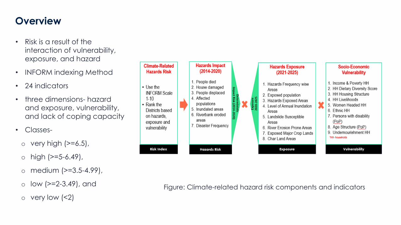
• Risk is a result of the interaction of vulnerability, exposure, and hazard
• INFORM indexing Method
• 24 indicators
• three dimensions- hazard and exposure, vulnerability, and lack of coping capacity
• Classes-
o very high (>=6.5),
o high (>=5-6.49),
o medium (>=3.5-4.99),
o low (>=2-3.49), and
o very low (<2)
Figure: Climate-related hazard risk components and indicators
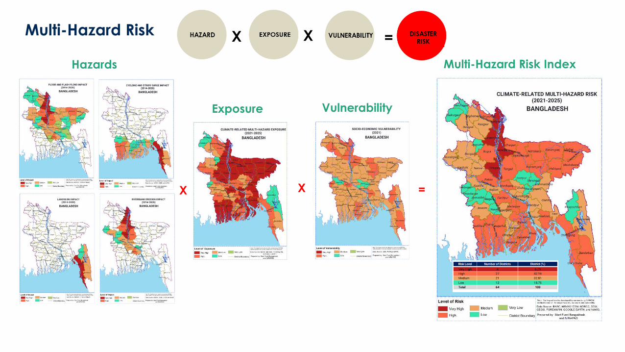
Multi-Hazard Risk
Hazards
X X =
Exposure Vulnerability
Multi-Hazard Risk Index
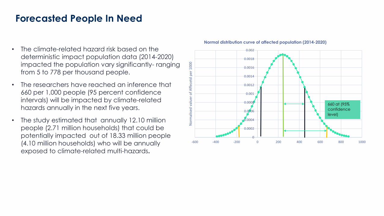
Forecasted People In Need
• The climate-related hazard risk based on the
deterministic impact population data (2014-2020)
impacted the population vary significantly- ranging
from 5 to 778 per thousand people.
• The researchers have reached an inference that
660 per 1,000 people (95 percent confidence
intervals) will be impacted by climate-related
hazards annually in the next five years.
• The study estimated that annually 12.10 million
people (2.71 million households) that could be
potentially impacted out of 18.33 million people
(4.10 million households) who will be annually
exposed to climate-related multi-hazards.
0
0.0002
0.0004
0.0006
0.0008
0.001
0.0012
0.0014
0.0016
0.0018
0.002
-600 -400 -200 0 200 400 600 800 1000
No
rmal
ised
val
uer
of
Aff
ecet
d p
er 1
00
0
Normal distribution curve of affected population (2014-2020)
660 at (95%
confidence
level)
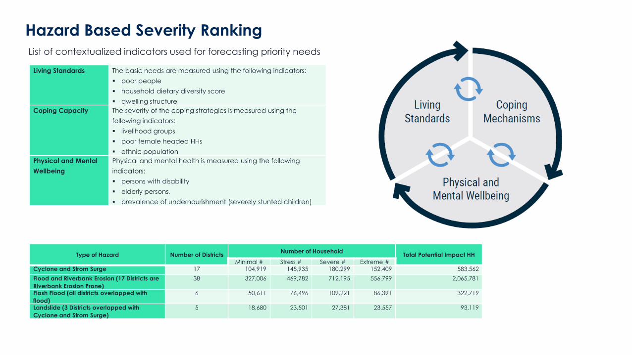
Hazard Based Severity Ranking
List of contextualized indicators used for forecasting priority needs
Living Standards The basic needs are measured using the following indicators:
▪ poor people
▪ household dietary diversity score
▪ dwelling structure
Coping Capacity The severity of the coping strategies is measured using the
following indicators:
▪ livelihood groups
▪ poor female headed HHs
▪ ethnic population
Physical and Mental
Wellbeing
Physical and mental health is measured using the following
indicators:
▪ persons with disability
▪ elderly persons,
▪ prevalence of undernourishment (severely stunted children)
Type of Hazard Number of DistrictsNumber of Household
Total Potential Impact HH
Minimal # Stress # Severe # Extreme #Cyclone and Strom Surge 17 104,919 145,935 180,299 152,409 583,562
Flood and Riverbank Erosion (17 Districts are
Riverbank Erosion Prone)
38 327,006 469,782 712,195 556,799 2,065,781
Flash Flood (all districts overlapped with
flood)
6 50,611 76,496 109,221 86,391 322,719
Landslide (3 Districts overlapped with
Cyclone and Strom Surge)
5 18,680 23,501 27,381 23,557 93,119
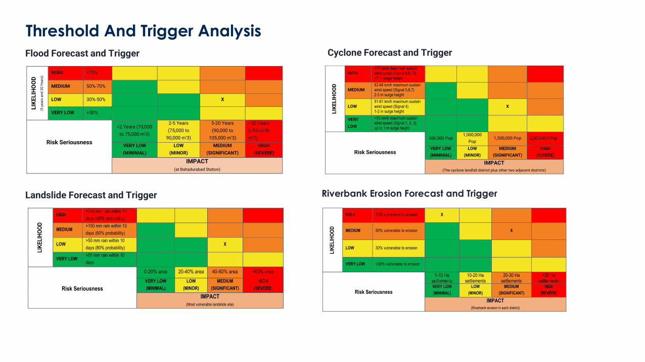
Threshold And Trigger Analysis
Flood Forecast and Trigger Cyclone Forecast and Trigger
Landslide Forecast and Trigger
LIK
EL
IHO
OD
HIGH >89 km/h maximum sustain wind speed (Signal 8,9,10) >3 m surge height
MEDIUM 62-88 km/h maximum sustain wind speed (Signal 5,6,7) 2-3 m surge height
LOW 51-61 km/h maximum sustain wind speed (Signal 4) 1-2 m surge height
X
VERY
LOW
<50 km/h maximum sustain wind speed (Signal 1, 2, 3) up to 1 m surge height
Risk Seriousness
500,000 Pop 1,000,000
Pop 1,500,000 Pop 2,000,000 Pop
VERY LOW
(MINIMAL)
LOW
(MINOR)
MEDIUM
(SIGNIFICANT)
HIGH
(SEVERE)
IMPACT
(The cyclone landfall district plus other two adjacent districts)
LIK
EL
IHO
OD
(5
ye
ars
an
d 2
0 Y
ea
rs) HIGH >70%
MEDIUM 50%-70%
LOW 30%-50% X
VERY LOW >30%
Risk Seriousness
<2 Years (70,000
to 75,000 m'3)
2-5 Years
(75,000 to
90,000 m'3)
5-20 Years
(90,000 to
105,000 m'3)
>20 Years
(>105,000
m'3)
VERY LOW
(MINIMAL)
LOW
(MINOR)
MEDIUM
(SIGNIFICANT)
HIGH
(SEVERE)
IMPACT
(at Bahadurabad Station)
LIK
EL
IHO
OD
HIGH >300 mm rain within 10
days (40% probability)
MEDIUM >150 mm rain within 10
days (60% probability)
LOW >50 mm rain within 10
days (80% probability) X
VERY LOW <50 mm rain within 10
days
Risk Seriousness
0-20% area 20-40% area 40-60% area >60% area
VERY LOW
(MINIMAL)
LOW
(MINOR)
MEDIUM
(SIGNIFICANT)
HIGH
(SEVERE)
IMPACT
(Most vulnerable landslide site)
Riverbank Erosion Forecast and Trigger
LIK
EL
IHO
OD
HIGH 70% vulnerable to erosion X
MEDIUM 50% vulnerable to erosion X
LOW 30% vulnerable to erosion
VERY LOW <30% vulnerable to erosion
Risk Seriousness
1-10 Ha settlements
10-20 Ha settlements
20-30 Ha settlements
>30 Ha settlements
VERY LOW
(MINIMAL)
LOW
(MINOR)
MEDIUM
(SIGNIFICANT)
HIGH
(SEVERE)
IMPACT
(Riverbank erosion in each district)
Questions and Answers
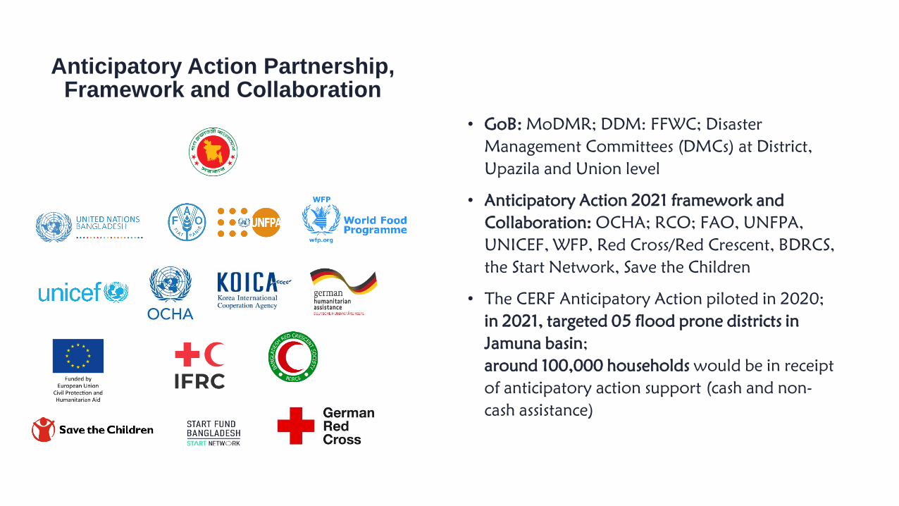
• GoB: MoDMR; DDM: FFWC; Disaster
Management Committees (DMCs) at District,
Upazila and Union level
• Anticipatory Action 2021 framework and
Collaboration: OCHA; RCO; FAO, UNFPA,
UNICEF, WFP, Red Cross/Red Crescent, BDRCS,
the Start Network, Save the Children
• The CERF Anticipatory Action piloted in 2020;
in 2021, targeted 05 flood prone districts in
Jamuna basin;
around 100,000 households would be in receipt
of anticipatory action support (cash and non-
cash assistance)
Anticipatory Action Partnership, Framework and Collaboration
DEM LULC RainfallWater
Level
Socio economic
factors
Final Target Areas
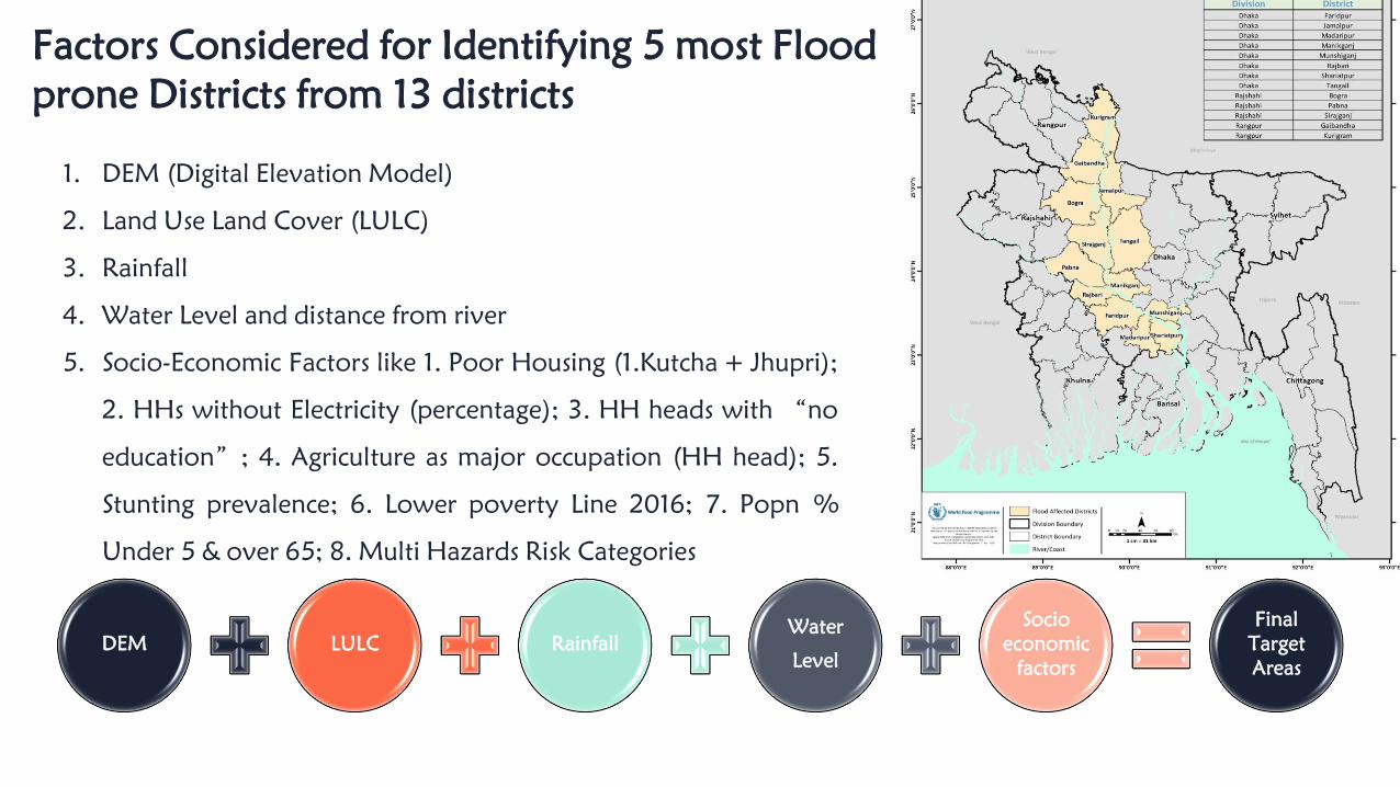
Factors Considered for Identifying 5 most Flood prone Districts from 13 districts
1. DEM (Digital Elevation Model)
2. Land Use Land Cover (LULC)
3. Rainfall
4. Water Level and distance from river
5. Socio-Economic Factors like 1. Poor Housing (1.Kutcha + Jhupri);
2. HHs without Electricity (percentage); 3. HH heads with “no
education”; 4. Agriculture as major occupation (HH head); 5.
Stunting prevalence; 6. Lower poverty Line 2016; 7. Popn %
Under 5 & over 65; 8. Multi Hazards Risk Categories
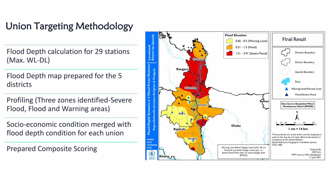
Union Targeting MethodologyFinal Result
Flood Depth calculation for 29 stations (Max. WL-DL)
Flood Depth map prepared for the 5 districts
Profiling (Three zones identified-Severe Flood, Flood and Warning areas)
Socio-economic condition merged with flood depth condition for each union
Prepared Composite Scoring
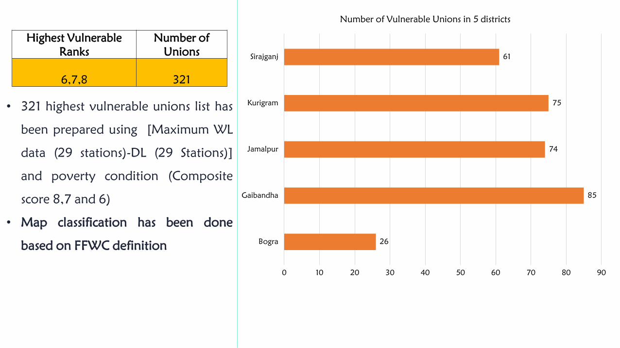
Highest Vulnerable Ranks
Number of Unions
6,7,8 321
• 321 highest vulnerable unions list has
been prepared using [Maximum WL
data (29 stations)-DL (29 Stations)]
and poverty condition (Composite
score 8,7 and 6)
• Map classification has been done
based on FFWC definition 26
85
74
75
61
0 10 20 30 40 50 60 70 80 90
Bogra
Gaibandha
Jamalpur
Kurigram
Sirajganj
Number of Vulnerable Unions in 5 districts
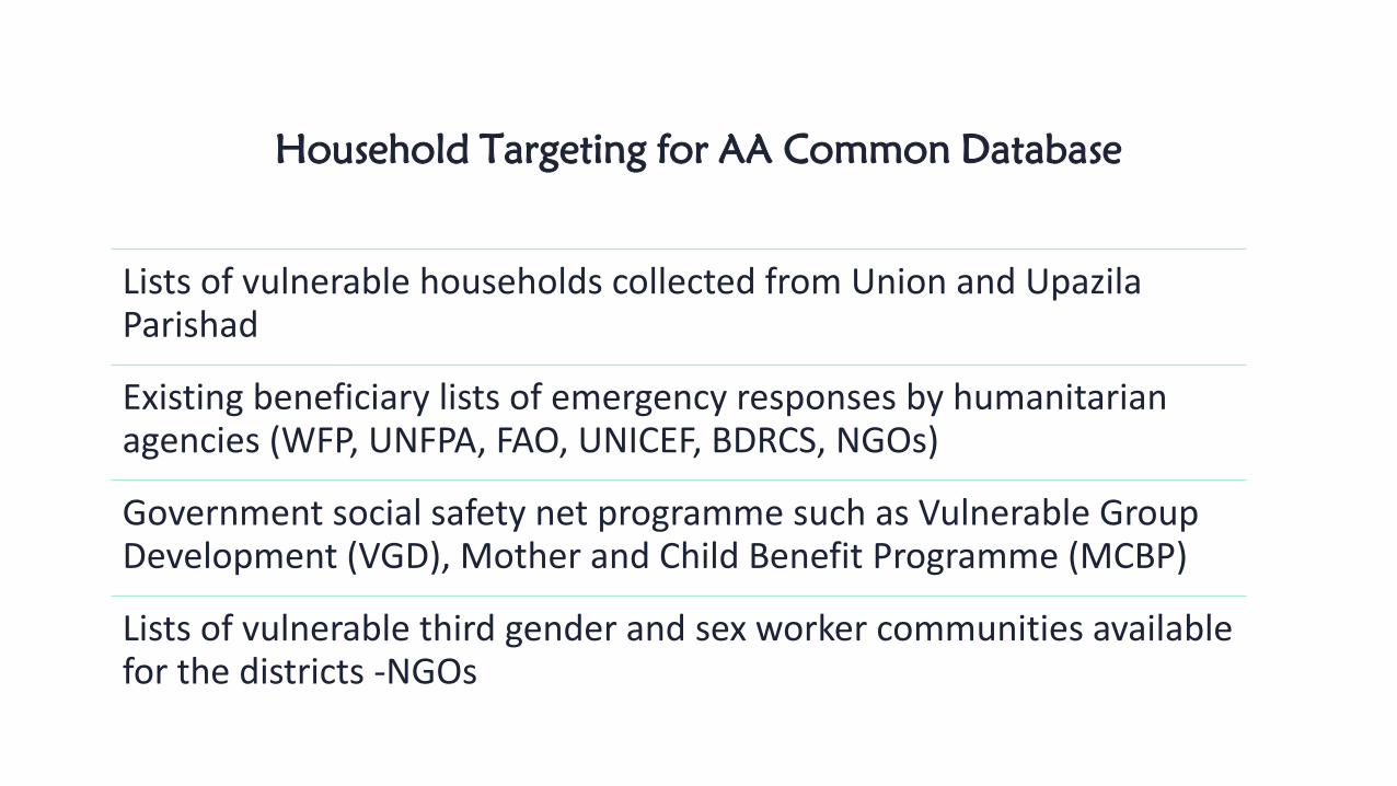
Household Targeting for AA Common Database
Lists of vulnerable households collected from Union and Upazila Parishad
Existing beneficiary lists of emergency responses by humanitarian agencies (WFP, UNFPA, FAO, UNICEF, BDRCS, NGOs)
Government social safety net programme such as Vulnerable Group Development (VGD), Mother and Child Benefit Programme (MCBP)
Lists of vulnerable third gender and sex worker communities available for the districts -NGOs

Vulnerability indicators for household verification
Structure of the participant's house
with facilities
HH experience in a severe flood
disaster in the last 5 years?
HH main source of income
HH amount of land (in decimals)
HH having total family member
HH having children, adolescent girl,
Women
HH having elderly member (Over 60
years)
HH having Widow/widower,
abandoned or divorced women?
Children of the HH involved in
labour/work outside of the home?
HH having Pregnant or lactating mother?
HH having person with disability (e.g. difficulty seeing, hearing,
walking/climbing, communicating, remembering/concentrating or self-care)
Ethnic/Indigenous HH
Female headed HHHH impacted by COVID-19 (Physically affected,
Lose of income and livelihoods)
Number of livestock (cow/buffalo) owned
by the household
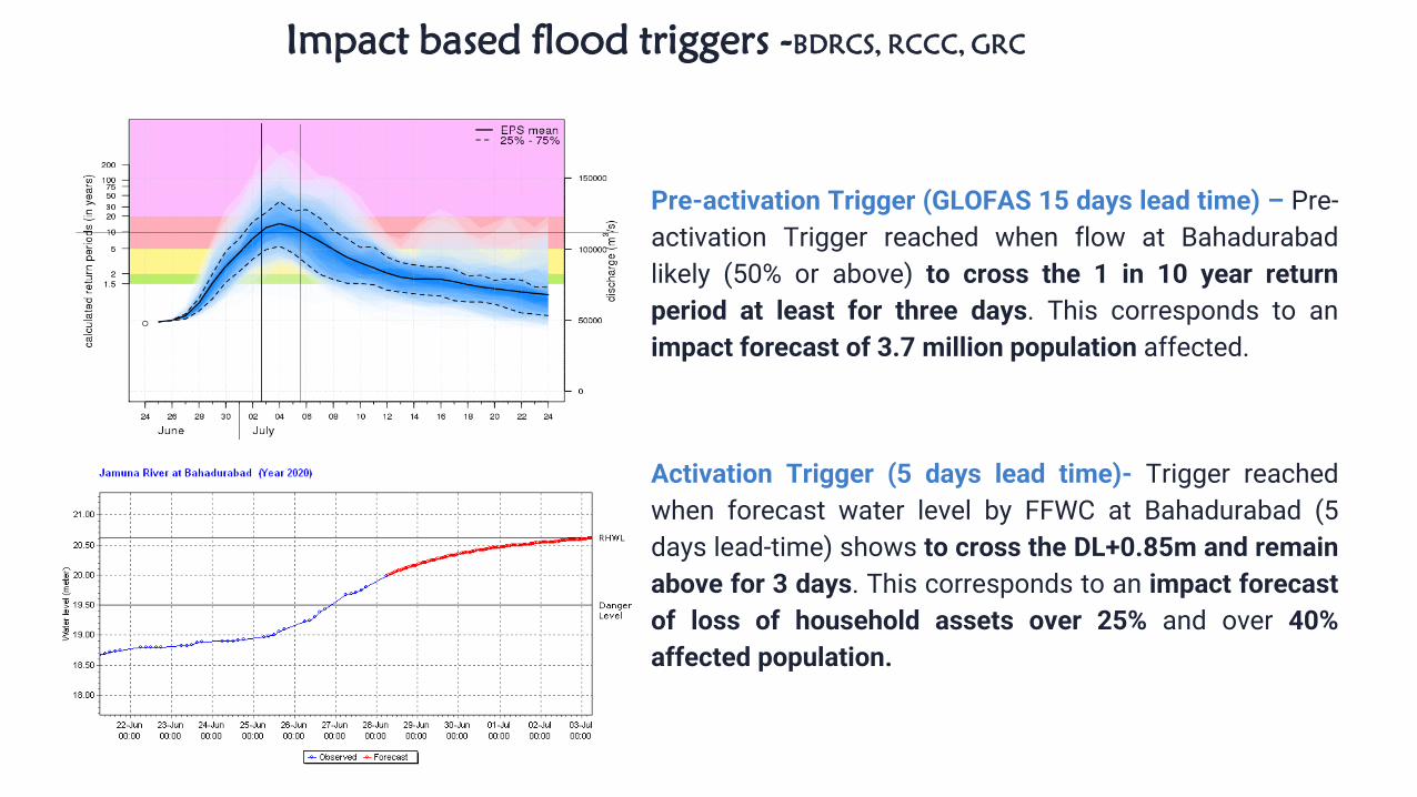
Pre-activation Trigger (GLOFAS 15 days lead time) – Pre-
activation Trigger reached when flow at Bahadurabad
likely (50% or above) to cross the 1 in 10 year return
period at least for three days. This corresponds to an
impact forecast of 3.7 million population affected.
Activation Trigger (5 days lead time)- Trigger reached
when forecast water level by FFWC at Bahadurabad (5
days lead-time) shows to cross the DL+0.85m and remain
above for 3 days. This corresponds to an impact forecast
of loss of household assets over 25% and over 40%
affected population.
Impact based flood triggers -BDRCS, RCCC, GRC

Real Time Geographical Targeting (after activation trigger)
RCCC Impact based
Forecast
VAM Analysis
MoDMR’sSituation Report Total 141 Unions
were targeted for AA
Thank you
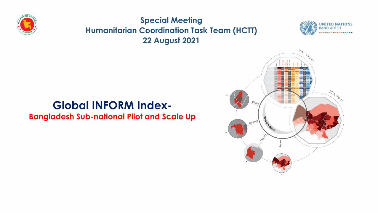
Global INFORM Index-Bangladesh Sub-national Pilot and Scale Up
Special Meeting
Humanitarian Coordination Task Team (HCTT)
22 August 2021

• INFORM is a collaboration of the Inter-Agency Standing Committee Reference Group on Risk, Early Warning and Preparedness and the European Commission.
• INFORM is a multi-stakeholder forum for developing shared, quantitative analysis relevant to humanitarian crises and disasters.
https://www.youtube.com/watch?v=NVcOiuDQIFs
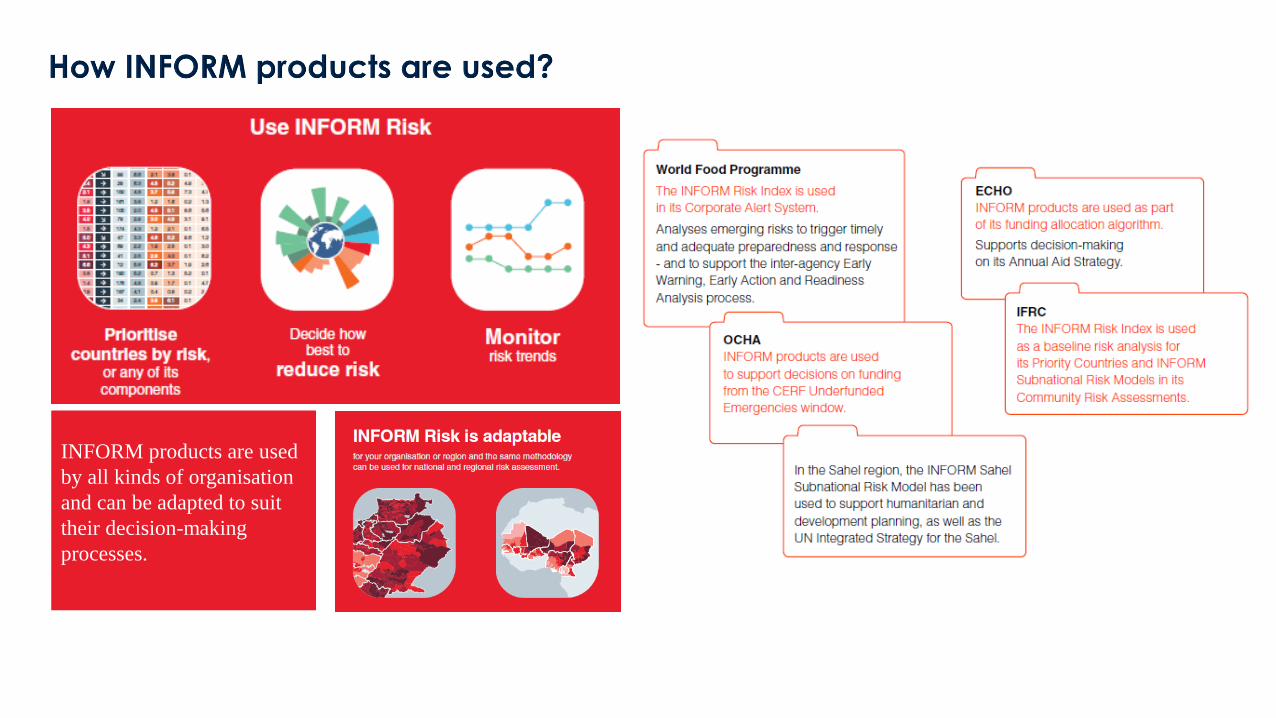
INFORM products are used
by all kinds of organisation
and can be adapted to suit
their decision-making
processes.
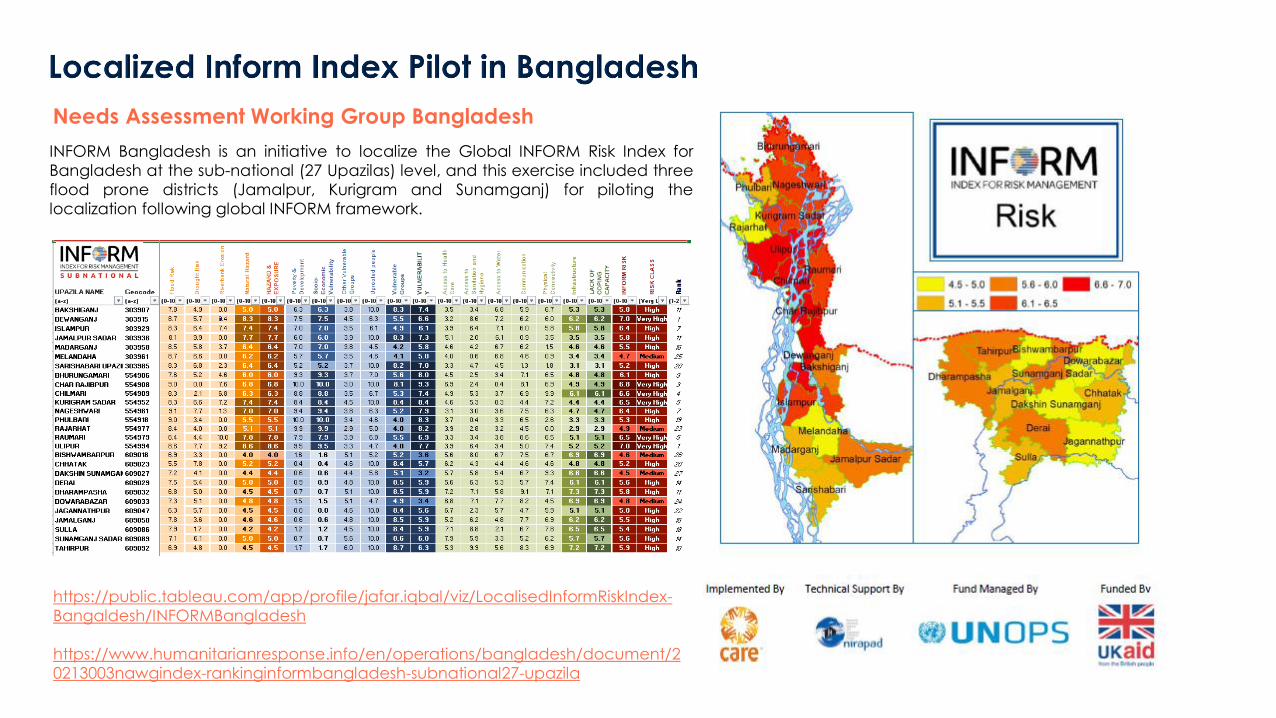
INFORM Bangladesh is an initiative to localize the Global INFORM Risk Index for
Bangladesh at the sub-national (27 Upazilas) level, and this exercise included three
flood prone districts (Jamalpur, Kurigram and Sunamganj) for piloting the
localization following global INFORM framework.
https://public.tableau.com/app/profile/jafar.iqbal/viz/LocalisedInformRiskIndex-
Bangaldesh/INFORMBangladesh
https://www.humanitarianresponse.info/en/operations/bangladesh/document/2
0213003nawgindex-rankinginformbangladesh-subnational27-upazila
Needs Assessment Working Group Bangladesh
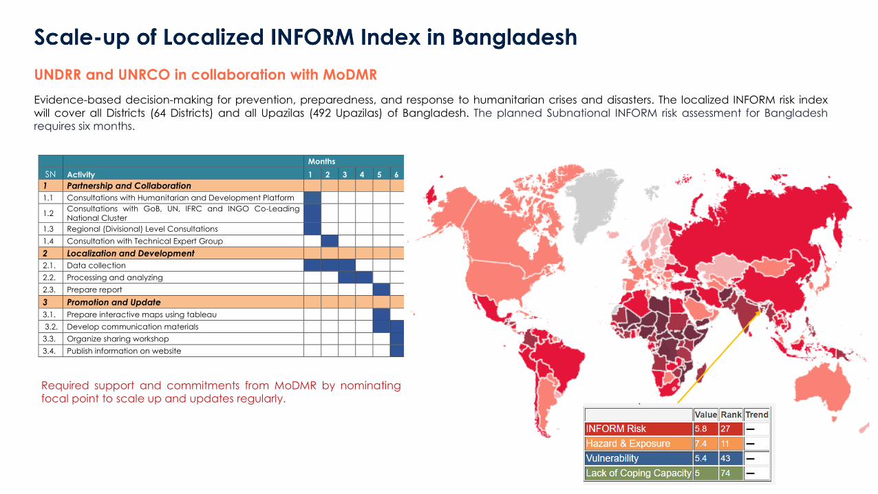
Evidence-based decision-making for prevention, preparedness, and response to humanitarian crises and disasters. The localized INFORM risk index
will cover all Districts (64 Districts) and all Upazilas (492 Upazilas) of Bangladesh. The planned Subnational INFORM risk assessment for Bangladeshrequires six months.
UNDRR and UNRCO in collaboration with MoDMR
Months
SN Activity 1 2 3 4 5 6
1 Partnership and Collaboration
1.1 Consultations with Humanitarian and Development Platform
1.2 Consultations with GoB, UN, IFRC and INGO Co-Leading National Cluster
1.3 Regional (Divisional) Level Consultations
1.4 Consultation with Technical Expert Group
2 Localization and Development
2.1. Data collection
2.2. Processing and analyzing
2.3. Prepare report
3 Promotion and Update
3.1. Prepare interactive maps using tableau
3.2. Develop communication materials
3.3. Organize sharing workshop
3.4. Publish information on website
Required support and commitments from MoDMR by nominatingfocal point to scale up and updates regularly.
Questions and Answers

![Climate Change & Disasters. Climate Change and Disasters “The report [Impacts, Adaptation & Vulnerability, IPCC 2007] confirms our worst fears – vulnerable](https://img.pdfslide.net/doc/110x75/56649e6b5503460f94b69049/climate-change-disasters-climate-change-and-disasters-the-report-impacts.jpg)