Embed Size (px)
Citation preview
Hydrological Sciences-Journal-des Sciences Hydrologiques, 46(1) February 2001 53
Multi-objective optimization for sustainable groundwater resource management in a semiarid catchment
Y. S. YANG, R. M. KALIN School of Civil Engineering, Queen's University of Belfast, Belfast BT7 INN, UK e-mail: [email protected]
Y. ZHANG Department of Hydraulic Engineering, Taiyuan University of Technology, Taiyuan 030024, China
X.LIN Institute of Environmental .Sciences, Beijing Normal University, 19 Xinjiekou Waidajie, Beijing 100875, China
L.ZOU Department of Environmental Engineering, Jilin University, Changchun 130026, China
Abstract Groundwater is an important water resource and its management is vital for integrated water resources development in semiarid catchments. The River Shiyang catchment in the semiarid area of northwestern China was studied to determine a sustainable multi-objective management plan of water resources. A multi-objective optimization model was developed which incorporated water supplies, groundwater quality, ecology, environment and economics on spatial and temporal scales under various detailed constraints. A calibrated groundwater flow model was supplemented by grey simulation of groundwater quality, thus providing two lines of evidence to use in the multi-objective water management. The response matrix method was used to link the groundwater simulation models and the optimization model. Multi-phase linear programming was used to minimize and compromise the objectives for the multi-period, conjunctive water use optimization model. Based on current water demands, this water use optimization management plan was able to meet ecological, environmental and economic objectives, but did not find a final solution to reduce the overall water deficit within the catchment.
Key words sustainable groundwater management; multi-objective optimization; conjunctive use; groundwater flow; groundwater quality; mathematical modelling; integrated water resources management; semiarid zones; China
Optimisation multi-objectifs de la gestion durable des ressources en eau souterraines dans un bassin hydrographique semi-aride Résumé Les nappes d'eau souterraines sont une importante composante des ressources en eau dans les régions semi-arides et leur gestion est vitale afin d'intégrer ces ressources dans le développement de ces régions. Le bassin hydrographique de la rivière Shiyang est situé dans une région semi-aride du Nord-Est de la Chine. Il a été étudié afin d'établir un plan de gestion durable des ressources en eau. Nous avons élaboré un modèle d'optimisation multi-objectifs appliqué à l'alimentation en eau, à la qualité des eaux souterraines, à l'écologie et à la gestion de l'environnement et de l'économie sous des contraintes détaillées exprimées à différentes échelles spatiales et temporelles. Un modèle d'écoulement des eaux souterraines calé est complété par une simulation grossière de la qualité des eaux souterraines, fournissant ainsi deux angles d'approche utilisables dans le cadre du modèle multi-objectifs. La méthode de la matrice de réponse est utilisée afin de coupler les modèles de simulation et le modèle d'optimisation. La programmation linéaire a été utilisée pour minimiser les fonctions-objectifs et réaliser
Open for discussion until I August 2001
56 Y. S. Yang et al.
sur la demande actuelle en eau, ce modèle d'optimisation de l'usage de l'eau est capable de satisfaire les objectifs écologiques, environnementaux et économiques mais ne fournit cependant pas de solution au déficit en eau global du bassin.
Mots clefs gestion durable des eaux souterraines; optimisation à objectifs multiples; utilisation conjointe; écoulement des eaux souterraines; qualité des eaux souterraines; modélisation mathématique; gestion intégrée des ressources en eau; zones semi-arides; Chine
INTRODUCTION
In semiarid environments, groundwater is an important and precious resource for municipal and rural supplies, eco-environment maintenance, and social and economic development. Protection and management of groundwater resources and understanding of the interactions between surface water, groundwater and human activities are crucial for sustainable water resources development and planning on a regional scale.
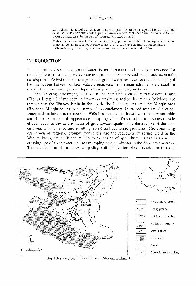
The Shiyang catchment, located in the semiarid area of northwestern China (Fig. 1), is typical of major inland river systems in the region. It can be subdivided into three areas: the Wuwey basin in the south, the Jinchang area and the Minqin area (Jinchang-Minqin basin) in the north of the catchment. Increased mining of groundwater and surface water since the 1950s has resulted in drawdown of the water table and decrease, or even disappearance, of spring yield. This resulted in a series of side effects, such as the deterioration of groundwater quality, the destruction of the eco-environmental balance and resulting social and economic problems. The continuing drawdown of regional groundwater levels and the reduction of spring yield in the Wuwey basin, are attributed mainly to expansion of agricultural irrigation areas, increasing use of river water, and overpumping of groundwater in the downstream areas. The deterioration of groundwater quality, soil salinization, desertification and loss of
!
0
- ' 8 ^ - - __r„ . . - / . /
\. - - —/ " /~ ,~_̂ _ . ^y /
( f /// N-x <vJiichans.-- ' U m ^ ^ ^ J
< ». •' - /W Reservoir \ •Qhang .̂ , tr^/S ^ j
J r/ <à-\ yti -\ \ % —^
•^'"àn /,4r i w * J > . -< * - • • > / s , i • • • ' • • •
r 'v
25 50km —
^1
/ /
—"\ - - '- \
/ /
/ j
\ )
y
-")
CO
Rivers and reservoirs
Spring groups
Catchment boundary
Modellimg boundary
Burried faults
Mountains
Desert
Geologic cross-sections
Fig. 1 A survey and the location of the Shiyang catchment.
Multi-objective optimization for sustainable groundwater resource management 57
arable land in the Minqin basin are caused by the overexploitation of groundwater, an improper increase in irrigation, and poor administration of well drilling. The whole series of environmental consequences of water uses may be worse than those addressed by Goudie (1997). Water resources problems remain an important factor constraining the regional economic development. Hence, proper management and sound protection of regional water resources are needed.
The approach presented herein employs a multi-objective optimization to solve the conflicting eco-environmental problems for sustainable development of the water resources. The overall objectives were to: (a) maintain current water utilization in a short planning period and meet water supply requirements in the long term; (b) perform conjunctive management of groundwater and surface water; (c) minimize groundwater quality deterioration caused by water development based on prediction trend; (d) meet increasing water demand for human and livestock, agriculture, industry and forestry uses, and control, eliminate and alleviate hazards that are caused by overexploitation of groundwater; and (e) achieve the best social, ecological, environmental and economic values of water use. Extensive data on regional water resources, ecology, hydrogeology and other environmental factors have been accumulated (GHS & CUST, 1989), which provided a solid basis for the multi-objective management and protection of water resources. A numerical groundwater flow model was constructed and calibrated to simulate the transient nature of the regional aquifer system. This was supplemented by lumped-parameter simulation of groundwater quality using grey model GM(2,1) (Shih et al., 1997). The groundwater flow and quality models thus provided two lines of evidence to incorporate quantity, groundwater level and solute concentration in the multi-objective water management.
Multi-objective optimization has been used before for conjunctive use of surface water and groundwater. Most previous studies were applied to water quantity optimization in local regions, such as in coastal areas (Emch & Yeh, 1998) and irrigation areas (Onta et al., 1991), or specifically for economic and policy analysis (Rosa, 1995). Groundwater quality was managed for unique wastewater treatment purposes (Alireza et al., 1994), or considered as a constraint in water management (Wong et al., 1997). In the Shiyang catchment, surface water and groundwater are closely interactive and frequently exchange in pearl-string-like basins. Groundwater quality and quantity are equally important to the eco-environment. The regional, multi-step and multi-objective water management plan discussed herein has complicated constraints in terms of water quantity, quality, economics and eco-environmental aspects. Therefore the groundwater flow and quality have been simulated first; then a multi-objective optimization scheme with objectives of groundwater level, quality and quantity and eco-environmental aspects has been developed. The response matrix and embedding techniques are usually used to couple groundwater models and optimization models (Duckstein et al., 1994; Yang & Lin, 1993). Peralta et al. (1991) argued that a steady-state embedding model required less processing time than a response matrix model. However, for regional problems with a greater number of objectives, the embedding model is not suitable because the constraint matrix may become too large (Yeh, 1992). The research reported herein showed that the response matrix model was more flexible and memory saving for the multi-period, multi-objective programming of the regional water resources management and was thereby used to couple the groundwater simulations into the multi-objective optimization model.
58 Y. S. Yang et al.
PHYSIOGRAPHY AND WATER USE
The Shiyang catchment is a sediment filled graben, with a total area of 30 000 km2. It is surrounded by mountains apart from the desert boundary in the east (Fig. 1). The annual average precipitation is 100-250 mm, whilst potential evaporation is 2000-3000 mm. Eight rivers with a total of 15.43 x 10⁸ mJ year"1 runoff originate from the Qilian Mountains and flow to the north. The rivers replenish the aquifer of the Wuwey basin at the foot of the mountains and overflow as spring groups on the forward position of the alluvial and diluvial fan. The River Shiyang is thereby formed from these spring groups. To the north of the Wuwey basin, the groundwater level is close to the ground surface and evaporation occurs there. Further northwards, the aquifer in the Minqin area is recharged with the waters from the lower reaches of the River Jinchang and the Honya Reservoir. The river water recharges groundwater upstream and supplies base flow to the river downstream.
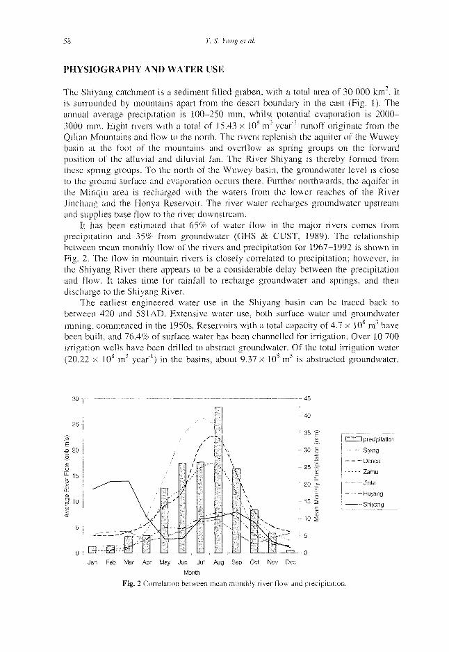
It has been estimated that 65% of water flow in the major rivers comes from precipitation and 35% from groundwater (GHS & CUST, 1989). The relationship between mean monthly flow of the rivers and precipitation for 1967-1992 is shown in Fig. 2. The flow in mountain rivers is closely correlated to precipitation; however, in the Shiyang River there appears to be a considerable delay between the precipitation and flow. It takes time for rainfall to recharge groundwater and springs, and then discharge to the Shiyang River.
The earliest engineered water use in the Shiyang basin can be traced back to between 420 and 58IAD. Extensive water use, both surface water and groundwater mining, commenced in the 1950s. Reservoirs with a total capacity of 4.7 x 10 nr' have been built, and 76.4% of surface water has been channelled for irrigation. Over 10 700 irrigation wells have been drilled to abstract groundwater. Of the total irrigation water (20.22 x 10⁸ nr1 year"1) in the basins, about 9.37 x 10⁸ m3 is abstracted groundwater.
I , I precipitation <
Siying j
Donda
Zamu i
Jinta !
Huyang j
Shiyang
Jan Feb Mar Apr May Jun Jul Aug Sep Oct Nov Dec
Month
Fig. 2 Correlation between mean monthly river flow and precipitation.
Multi-objective optimization for sustainable groundwater resource management 59
Furthermore, reservoirs intercepting river water at the gaps bordering the Qilian Mountains (Fig. 1) have suffered from extensive evaporation. All these factors have upset the groundwater-surface water balance. The flow of the River Shiyang decreased from 5.7 x 10⁸ m3 year"1 in the 1950s to 2.2 x 10⁸ m3 year ' in the 1980s-1990s. There has been a decrease in water replenishment to groundwater and springs, so farmers in the middle and lower reaches overpumped groundwater for irrigation. The rate of groundwater table drawdown is 0.25-0.57 m year"1, and average groundwater levels in those areas have dropped 4-7 m since the 1960s.
An extraordinary contlict between water supply and demand exists in the catchment. The average overexploitation of groundwater was 4.14 x 10 m"1 year"1 during the period 1978-1991. This heavy overexploitation induced upper salinized groundwater to move vertically to the lower aquifer and degrade the water quality in some areas. Some farmland was discarded because of salinization and insufficient freshwater was available for irrigation. The native vegetation in this semiarid area adapted to a water level at 3-5 m depth. A decline of groundwater level to the depth of 7 m resulted in much of the natural vegetation dying off, which is threatening the vegetation in most of the area. Based on the research in the Minqin area (GHS & CUST, 1989), when the total dissolved solids (TDS) in groundwater is 1000-1500 mg l"1, the cover rate of vegetation is 60-70%; at 2000-2500 mg l"1 of TDS the cover rate is 30-60%; and when TDS is more than 10 000 mg F1, vegetation has mostly died off. All of these factors cause rapid disappearance of this oasis. Therefore, a protection and management plan for conjunctive use of surface water and groundwater on the catchment scale was timely to meet the water requirements of agriculture and industry, and to alleviate social, ecological and environmental problems.
HYDROGEOLOGY AND HYDROCHEMISTRY
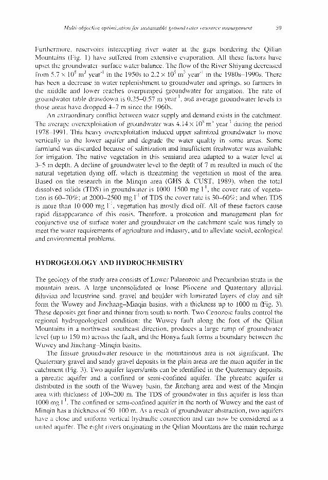
The geology of the study area consists of Lower Palaeozoic and Precambrian strata in the mountain areas. A large unconsolidated or loose Pliocene and Quaternary alluvial, diluvian and lacustrine sand, gravel and boulder with laminated layers of clay and silt form the Wuwey and Jinchang-Minqin basins, with a thickness up to 1000 m (Fig. 3). These deposits get finer and thinner from south to north. Two Cenozoic faults control the regional hydrogeological condition; the Wuwey fault along the foot of the Qilian Mountains in a northwest-southeast direction, produces a large ramp of groundwater level (up to 150 m) across the fault, and the Honya fault forms a boundary between the Wuwey and Jinchang-Minqin basins.
The fissure groundwater resource in the mountainous area is not significant. The Quaternary gravel and sandy gravel deposits in the plain areas are the main aquifer in the catchment (Fig. 3). Two aquifer layers/units can be identified in the Quaternary deposits, a phreatic aquifer and a confined or semi-confined aquifer. The phreatic aquifer is distributed in the south of the Wuwey basin, the Jinchang area and west of the Minqin area with thickness of 100-200 m. The TDS of groundwater in this aquifer is less than 1000 mg ]"'. The confined or semi-confined aquifer in the north of Wuwey and the east of Minqin has a thickness of 50-100 m. As a result of groundwater abstraction, two aquifers have a close and uniform vertical hydraulic connection and can now be considered as a united aquifer. The eight rivers originating in the Qilian Mountains are the main recharge
60 Y. S. Yang et al.
| | Gravel [ " J Silt
j | Sand [~J Clay
[ I Fine sand ^ j j j Mudstone
l;j;--';| Conglomerate
| j | § | Sandstone
\' '• • :| Granite
Faults
| ,5-j-7, | Boreholes with depth (m)
Fig. 3 Geological cross-sections of the basins (locations are shown in Fig. 1).
source. Calculation by the Ganshu Institute of Geosciences (1992) suggests that 60% of groundwater recharge of the Wuwey basin comes from leakage of rivers and irrigation ditches. The remaining recharge includes lateral inflow from the mountains, irrigation returning water, precipitation and condensed water. For the Jinchang-Minqin basin, the lateral inflow from the Wuwey basin and the leakage of the River Jinchang account for 40% of groundwater recharge, leakage from irrigation ditches 50%, and precipitation 10%. The discharge from the groundwater includes springs, évapotranspiration, and human abstraction. A complicated characteristic of the systems is that recharge and discharge happen simultaneously throughout the Minqin basin.
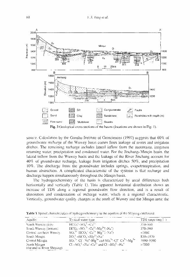
The hydrogeochemistry of the basin is characterized by areal differences both horizontally and vertically (Table 1). This apparent horizontal distribution shows an increase of TDS along a regional groundwater flow direction, and is a result of dissolution and condensation of recharge water, which is a regional characteristic. Vertically, groundwater quality changes in the north of Wuwey and the Minqin area: the
Table 1 Spatial characteristics of hydrogeochemistry in the aquifers of the Shiyang catchment.
Aquifer Typical water type TDS range ( m g r )
South Wuwey (top) South Wuwey (bottom) Central-northern Wuwey South Minqin Central Minqin North Minqin (the end of River Shiyang)
HCCV-SCV-Ca-* 370-560 HCO :r-S04
2~-Ca2+-Mg2+(-Na+) 370-560 S04
2~-HCCV-Ca2+-Mg2+(-Na+) < 1000 S04
2~-HCCV-Mg2+-Na+ 830-1970 S04
2~-Cr-Na+-Mg2 + and S042~-Cr-Ca2+-Mg2+ 1000-9390
Cr-S042~-Na+-Ca2 + and Cr-S04
2~-Na+ " >7000

Multi-objective optimization for sustainable groundwater resource management 61
TDS level is 1000-10 000 mg 1" in the top zones (depth < 20 m), and decreases to 500 mg F1 beneath that (depth 20-300 m). Due to the reduction of surface water resources in the Jinchang-Minqin basin, more and more groundwater was abstracted for irrigation. This resulted in soil salinization, which accordingly increased the TDS in shallow groundwater. The water mining from a confined aquifer in the Minqin area induced the upper salty water to migrate to the lower aquifer and increased the TDS value. The TDS value of groundwater has reached 2300 mg l"1 in some wells.
SIMULATION OF GROUNDWATER FLOW AND QUALITY
A distributed numerical groundwater flow model was constructed to represent the combined hydrogeological units and the interaction between groundwater and surface water in the catchment. The finite element model (Yang & Lin, 1993) was used to simulate the transient groundwater flow and provide a basis for the multi-objective optimization of water management. The model area is 8784 km" consisting the Wuwey, Jinchang and Minqin administrative regions. Considering the thickness of the aquifer (drilled thickness of 200 m) and the small variation in the regional groundwater table (annual average 0.1-0.6 m), the temporal fluctuations of the groundwater table can be ignored. Therefore, the groundwater flow in the phreatic aquifer was linearized and the regionally integrated groundwater flow system was governed by a confined groundwater equation (Bear, 1972). The parameters of transmissivity (incorporating hydraulic conductivity and thickness) and composite storage coefficient were adopted in the conceptual model of the regional groundwater simulation. The Quaternary porous media aquifer was represented as an isotropic and heterogeneous two-dimensional depth-integrated system. The sources and sinks of the groundwater system included effective precipitation, leakage of rivers and irrigation ditches, returning irrigation water, seepage of flooding, évapotranspiration, spring yield and abstraction. The northern and northeastern boundary conditions were groundwater heads, and the northwestern one was a no-flow boundary (flow-line). The rest of the Minqin boundary was impermeable apart from the inflow at the Jinchang River. The south of the Wuwey basin was represented as permeable in-flow boundary along the fault, and the eastern boundary condition along the desert was a groundwater head (Fig. 1).
A triangle-finite-element discretization was adopted using 527 elements and 313 nodes. Taking into consideration the historical abstraction data, groundwater regime and climate change, six time periods between 1 October 1986 and 1 January 1987 were used for the model calibration. Ninety three target nodes were taken from field observation. Based on pumping tests, the calibrated hydrogeological parameters of the model were 10-6000 m" day'1 for the transmissivity and 0.01-0.3 for the specific yield at different spatial locations (heterogeneous media). The overall calibration was found to be satisfactory with the exception of a few boreholes near Wuwey Town which was probably due to the poor representation of regional water level at the boreholes. Figure 4 shows the typical calibration results of the groundwater flow model in the basins. The calibrated model was validated using observation data from the period 1 January 1986-1 January 1992. The model produced good matches between observed and computed values of groundwater levels.
The hydrogeochemistry of the catchment was analysed previously by GHS & CUST (1989) using a multivariate statistical model with pH, HC03~, CF, S04
2~, Ca2+,

62 Y. S. Yang et al.
Head(m) 1326
1325
1324
1323
4322
1363
1362
1361
1360
1359
1358
0 100 200 300 400 500 600 700
1339
11338 •
'1337
1336 -
1546 T
1545 |
1544 -
1543 |
1542 !
100 200 300 400 500 600 /Où
100 200 300 400 500 600 700 800
Fig. 4 Selected calibration results of the groundwater flow simulation model (solid lines are calculated, dots are field observed data).
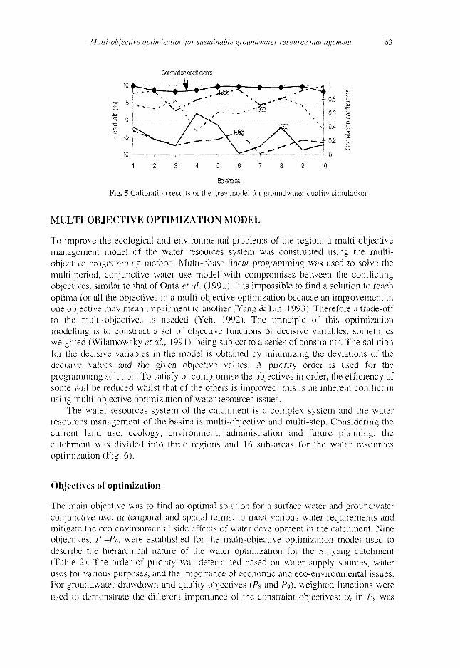
Mg~+, NaT, TDS and TH (total hardness) of the groundwater. The analysis result shows that TDS can be used as a marker for the groundwater quality simulation. The TDS is a reflection of the hydrogeochemical mechanism and water evolution in a groundwater system which is partially unknown. This system, therefore considered as a grey system (Deng, 1993), can be simulated and predicted by grey models using time series observation (Shih et al., 1997). The concentration of TDS and groundwater abstraction were delineated as the GM(1,2) model:
a [cl,,--C.r,, + "C (i)
C„ = C). •C '
where Cm and C^,, are the concentration and accumulated concentration at time /
repsectively, Q1^ the accumulated abstraction at t, and a, b the model coefficients.
This GM(1,2) model was calibrated with the observation data during 1984-1992 at typical observation boreholes. Figure 5 shows the calibration residual tests of the grey model in various time periods and the correlation coefficients at 10 boreholes. The corelation coefficients of the model at various boreholes were greater than 0.9, and the calibration residuals less than 10%, which demonstrated that the increase in TDS was caused mainly by over-abstraction in the study area.
Multi-objective optimization for sustainable groundwater resource management 63
Correlation coefficients
Fig. 5 Calibration results of the grey model for groundwater quality simulation.
MULTI-OBJECTIVE OPTIMIZATION MODEL
To improve the ecological and environmental problems of the region, a multi-objective management model of the water resources system was constructed using the multi-objective programming method. Multi-phase linear programming was used to solve the multi-period, conjunctive water use model with compromises between the conflicting objectives, similar to that of Onta et al. (1991). It is impossible to find a solution to reach optima for all the objectives in a multi-objective optimization because an improvement in one objective may mean impairment to another (Yang & Lin, 1993). Therefore a trade-off to the multi-objectives is needed (Yeh, 1992). The principle of this optimization modelling is to construct a set of objective functions of decisive variables, sometimes weighted (Wilamowsky et al., 1991), being subject to a series of constraints. The solution for the decisive variables in the model is obtained by minimizing the deviations of the decisive values and the given objective values. A priority order is used for the programming solution. To satisfy or compromise the objectives in order, the efficiency of some will be reduced whilst that of the others is improved: this is an inherent conflict in using multi-objective optimization of water resources issues.
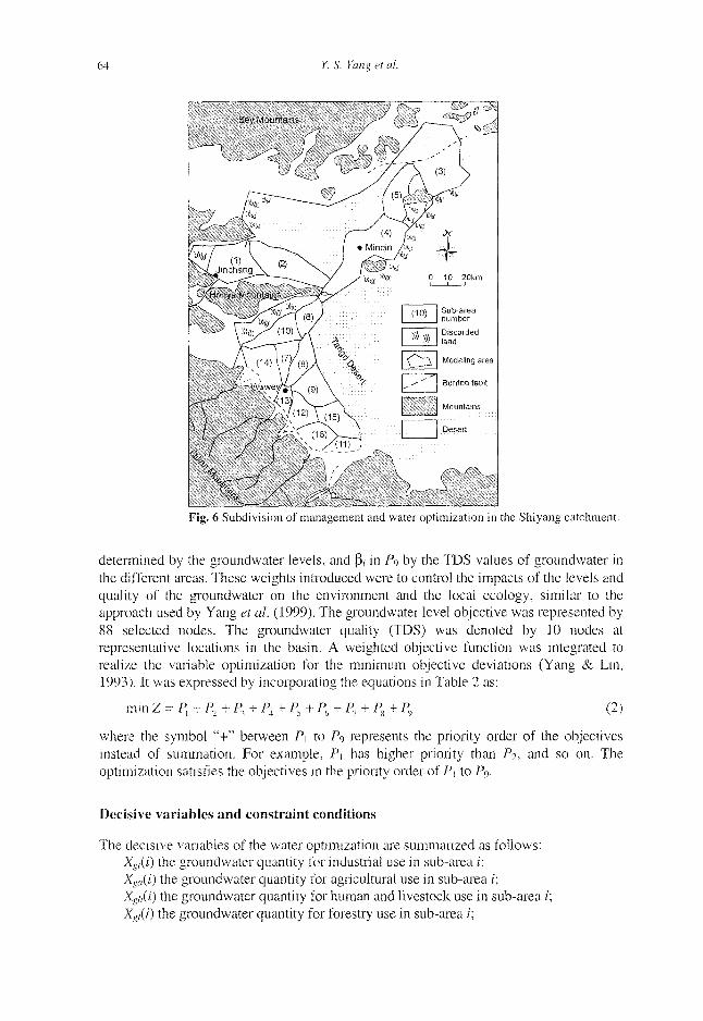
The water resources system of the catchment is a complex system and the water resources management of the basins is multi-objective and multi-step. Considering the current land use, ecology, environment, administration and future planning, the catchment was divided into three regions and 16 sub-areas for the water resources optimization (Fig. 6).
Objectives of optimization
The main objective was to find an optimal solution for a surface water and groundwater conjunctive use, in temporal and spatial terms, to meet various water requirements and mitigate the eco-environmental side effects of water development in the catchment. Nine objectives, P1-P9, were established for the multi-objective optimization model used to describe the hierarchical nature of the water optimization for the Shiyang catchment (Table 2). The order of priority was determined based on water supply sources, water uses for various purposes, and the importance of economic and eco-environmental issues. For groundwater drawdown and quality objectives (Pg and P9), weighted functions were used to demonstrate the different importance of the constraint objectives: a, in Pg was
64 Y. S. Yang et al.
Kig. 6 Subdivision "I management and water optimization in the Shiyang catchment.
determined by the groundwater levels, and P, in P9 by the TDS values of groundwater in the different areas. These weights introduced were to control the impacts of the levels and quality of the groundwater on the environment and the local ecology, similar to the approach used by Yang et al. (1999). The groundwater level objective was represented by 88 selected nodes. The groundwater quality (TDS) was denoted by 10 nodes at representative locations in the basin. A weighted objective function was integrated to realize the variable optimization for the minimum objective deviations (Yang & Lin, 1993). It was expressed by incoiporating the equations in Table 2 as:
mm Z = Pl+P2+P3+Pi + P5+P6+P7+Ps+P9 (2)
where the symbol "+" between Pi to Pc, represents the priority order of the objectives instead of summation. For example, P\ has higher priority than P2, and so on. The optimization satisfies the objectives in the priority order of P] to Pc,.
Decisive variables and constraint conditions
The decisive variables of the water optimization are summarized as follows: Xc,'(0 the groundwater quantity for industrial use in sub-area /; Xs„(i) the groundwater quantity for agricultural use in sub-area i; Xsi,(i) the groundwater quantity for human and livestock use in sub-area 2; Xgf(i) the groundwater quantity for forestry use in sub-area /;
Multi-objective optimization for sustainable groundwater resource management 65
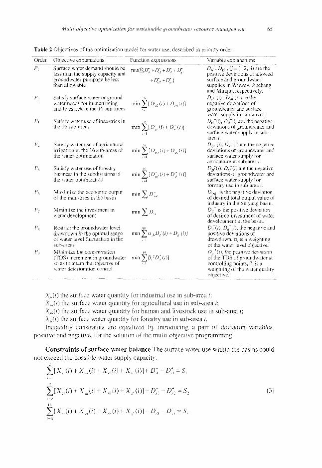
Table 2 Objectives of the optimization model for water use, described in priority order.
Order Objective explanations Function expressions Variable explanations
P\ Surface water demand should be xaaSiD* + D* + 0+ + IT less than the supply capacity and sl l2 d sl
groundwater pumpage be less + £r, + DtO than allowable
PT Satisfy surface water or ground ie water needs for human being min V [ D ~k (/) + D j , (/)] and livestock in the 16 sub-areas M
P I Satisfy water use of industries in io the 16 sub-areas min y\[D^ (i) + D[] (/)]
Satisfy water use of agricultural ic irrigation in the 16 sub-areas of m i n V [D~lt(i) + D~a(i)} the water optimization f=1
Satisfy water use of forestry i6 business in the subdivisions of mm "y^[D~f (/') + D~f (i)] the water optimization i=1
Maximize the economic output m j n V Q-of the industries in the basin - " ""'
PA
P<
P>>
Minimize the investment in water development >SA;
min ]T a, [Dj(i) + £>;(/)] Restrict the groundwater level drawdown in the optimal range of water level fluctuation in the sub-areas Minimize the concentration io (TDS) increment in groundwater min jT (3,|D'm(i)] so as to attain the objective of . i water deterioration control
A / , £>/,(/ '=1>2, 3) are the positive deviations of allowed surface and groundwater supplies in Wuwey, Jinchang and Minqin, respectively. Ds,;(i), D,;,""(i) are the negative deviations of groundwater and surface water supply in sub-area i. Dgi'd), Dtf(i) are the negative deviations of groundwater and surface water supply in sub-area i.
Dg.Jd), As,r(0 are the negative deviations of groundwater and surface water supply for agriculture in sub-area /. Dg(i), Dgf(i) are the negative déviations of groundwater and surface water supply for forestry use in sub-area ;'. Dim is the negative deviation of desired total output value of industry in the Shiyang basin. Dm
+ is the positive deviation of desired investment of water development in the basin. D/(i), D/(i), the negative and positive deviations of drawdown, a,- is a weighting of the water level objective. D„*(i), the positive deviation of the TDS of groundwater at controlling points, (3, is a weighting of the water quality-objective.
Xs,(i) the surface water quantity for industrial use in sub-area f; Xsa(i) the surface water quantity for agricultural use in sub-area i; Xsi,(i) the surface water quantity for human and livestock use in sub-area /'; Xsj(i) the surface water quantity for forestry use in sub-area /. Inequality constraints are equalized by introducing a pair of deviation variables,
positive and negative, for the solution of the multi-objective programming.
Constraints of surface water balance The surface water use within the basins could not exceed the possible water supply capacity.
£ [X„ (o + xm (0 + xsh (0 + xsf (0] + D- - D;, = s,
^[XZI(Ï) + xm(i) + xji) + xsfaj] + D;2- D;2 = s2
16
YJ [XS, (/) + xm a) + xsh (/) + xsf (/)] + D:3 - D;3 = s3
(3)
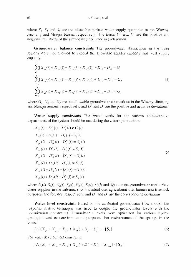
66 Y. S. Yang et al.
where Si, S? and S3 are the allowable surface water supply quantities in the Wuwey, Jinchang and Minqin basins, respectively. The ternis D+ and D~ are the positive and negative deviations of the surface water balance in each region.
Groundwater balance constraints The groundwater abstractions in the three regions were not allowed to exceed the allowable aquifer capacity and well supply capacity.
t^Jo+xjo+x^+x^n+D-, -D;, = G, ;' = !
g [xsl (o + x m (i) + xgh (i) + xsf (/) j + D ; : - D;2 = G2 (4)
jr [x„.(o + xs„ (o + xsh a) + xKf (/)j + D;3 - D;3 = G3 i-b
where G\, G2 and G3 are the allowable groundwater abstractions in the Wuwey, Jinchang and Minqin regions, respectively, and D^ and IT are the positive and negative deviations.
Water supply constraints The water needs for the various administrative departments of the system should be met during the water optimization.
XX,(/) + D; . (O-D; . (O = G,.(O
XJO + D'in-D^ (/) = S,(0
XJi) + Dm(i)-D;a(i) = Ga{i)
xsA0 + D;m(i)-D^(i) = stt(i)
XS / , ( / ) + £>; / 1 ( / ) -D; A (O = GA(/) ( 5 )
x,/,(0+ £>;,(/)- D;„ d) = sh(i)
Xxf(i) + D-Kf(i)-Dlf(j) = G,(j)
Xil(i) + D-(i)~D:t(0 = Sf(D
where G,(7), S,(/), Ga(i), Sfl(/), G/,(0> 5/,(0> G/(7) and S/(z') are the groundwater and surface water supplies in the sub-area /' for industrial use, agricultural use, human and livestock purposes, and forestry, respectively, and D+ and D~ are the corresponding deviations.
Water level constraints Based on the calibrated groundwater flow model, the response matrix technique was used to couple the groundwater levels with the optimization constraints. Groundwater levels were optimized for various hydro-geological and eco-environmental puiposes. For maintenance of the springs in the basin:
[A](Xgi + Xm + Xgh + XKf ) + D; - £>; = - [5 0 ] (6)
For water development constraint:
[A](XKi + Xm + XKll + X:<f ) + D; - D: = [Snm ] - [S0 ] (7)
Multi-objective optimization for sustainable groundwater resource management 67
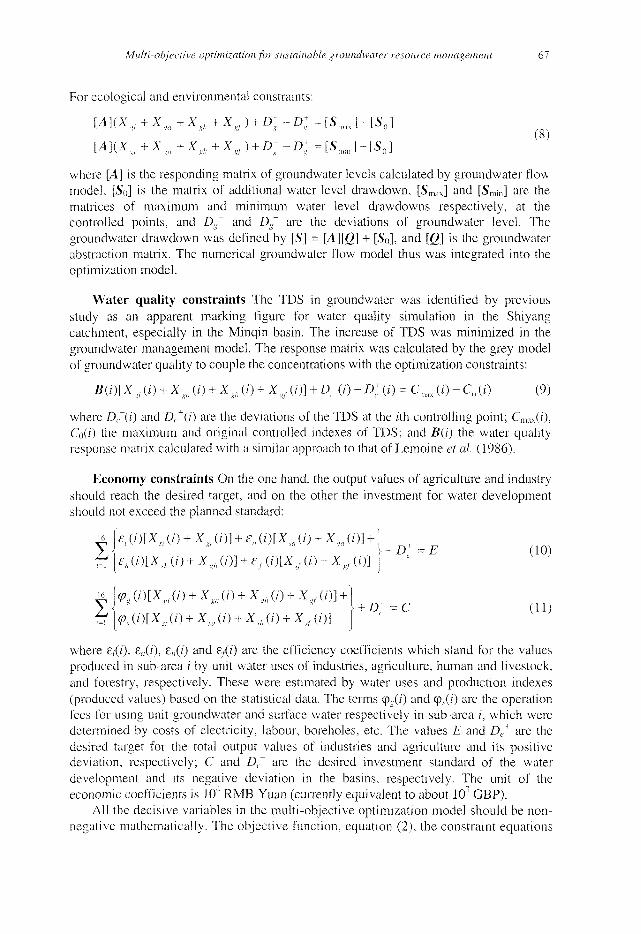
For ecological and environmental constraints:
[A\(Xgl +Xga+XKh+Xltr) + D;-D;=[Sma]-[S0]
[AKXsl+Xxn+X^+XKf) + Ds--D; =[Sn,„]-[SQ]
where [A] is the responding matrix of groundwater levels calculated by groundwater flow-model, [So] is the matrix of additional water level drawdown, [Smax] and [Sm;,i] are the matrices of maximum and minimum water level drawdowns respectively, at the controlled points, and Dg
+ and Df are the deviations of groundwater level. The groundwater drawdown was defined by [S] = [A][g] + [So], and [Q] is the groundwater abstraction matrix. The numerical groundwater flow model thus was integrated into the optimization model.
Water quality constraints The TDS in groundwater was identified by previous study as an apparent marking figure for water quality simulation in the Shiyang catchment, especially in the Minqin basin. The increase of TDS was minimized in the groundwater management model. The response matrix was calculated by the grey model of groundwater quality to couple the concentrations with the optimization constraints:
Bd)[xfi (/) + xga (o + x^ (o + zs/ (/)] + D; (o - D ; (/) = c,ms (o - c0 (0 (9)
where D,~{i) and D, +(i) are the deviations of the TDS at the z'th controlling point; Cmax(i), Cod) the maximum and original controlled indexes of TDS; and B(i) the water quality response matrix calculated with a similar approach to that of Lemoine et ai (1986).
Economy constraints On the one hand, the output values of agriculture and industry should reach the desired target, and on the other the investment for water development should not exceed the planned standard:
^l£,(i)lXu(i) +X,,,([)] +ea(t)[X JO+X,J')1+) Y "• ' \-D:=E (10)
tT [£>,(i)[Xsh(/) + XKh(/)] + £f (i)[Xsf (/) + Xs/ (/)] J
y * \+D~ = C (H) t!\<P.X')[x,l(0 + xm(i) + xji) + xsf(t)) j
where £,{/), e„(i), 8;,(/) and 6/(0 are the efficiency coefficients which stand for the values produced in sub-area / by unit water uses of industries, agriculture, human and livestock, and forestry, respectively. These were estimated by water uses and production indexes (produced values) based on the statistical data. The terms <pg(i) and cp.v(0 are the operation fees for using unit groundwater and surface water respectively in sub-area /, which were determined by costs of electricity, labour, boreholes, etc. The values E and De
+ are the desired target for the total output values of industries and agriculture and its positive deviation, respectively; C and D(~ are the desired investment standard of the water development and its negative deviation in the basins, respectively. The unit of the economic coefficients is 10 RMB Yuan (currently equivalent to about 101 GBP).
All the decisive variables in the multi-objective optimization model should be non-negative mathematically. The objective function, equation (2), the constraint equations
68 Y S. Yang et al.
(3)-(ll) and the equations in Table 2 form the multi-objective programming model of the Shiyang catchment.
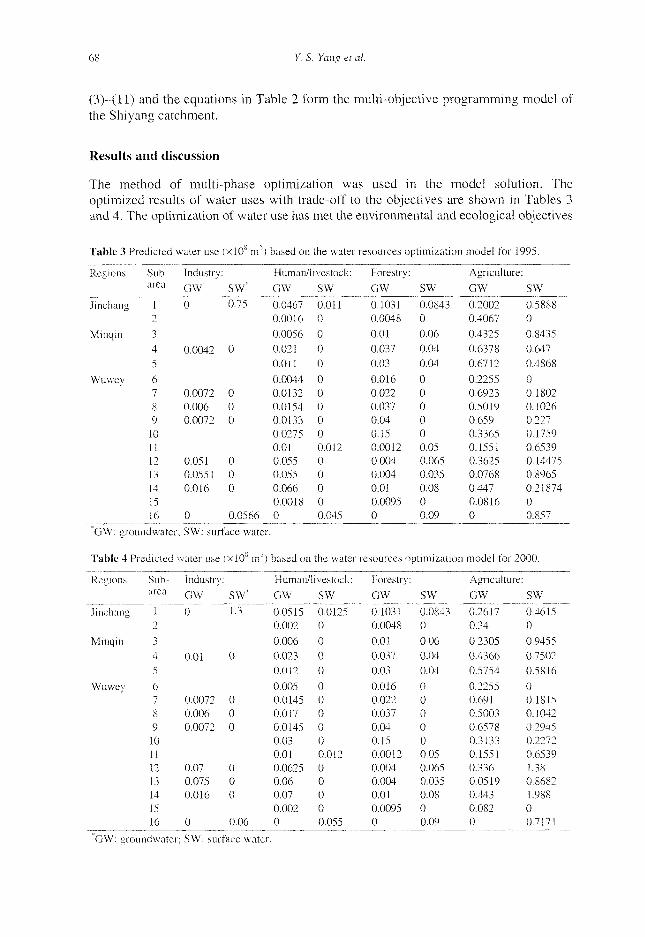
Results and discussion
The method of multi-phase optimization was used in the model solution. The optimized results of water uses with trade-off to the objectives are shown in Tables 3 and 4. The optimization of water use has met the environmental and ecological objectives
Table 3 Predicted water use
Regions
Jinchang
Minqin
Wuwey
"GW: groi
Table 4 Pi
Regions
Jinchang
Minqin
Wuwey
Sub-area
1 T
3 4
5
6 7 8 9
10 11 12 13 14 15 16
indwater
•edicted
Sub-area
1 2
3 4
5
6 7 8 9 10 11 12 13 14 15 16
Industry:
GW*
0
0.0042
0.0072 0.006 0.0072
0.051 0.0551 0.016
0
(x l0 s m ;
SW*
0.75
0
0 0 0
0 0 0
0.0566
') based on
Human/I
GW
0.0467 0.0016
0.0056 0.021
0.011
0.0044 0.0132 0.0154 0.0133 0.0275 0.01 0.055 0.055 0.066 0.0018 0
; SW: surface water.
water use
Industry
GW"
0
0.01
0.0072 0.006 0.0072
0.07 0.075 0.016
0
(xI0 s m
SW*
1.3
0
0 0 0
0 0 0
0.06
') based on
Human/'
GW
0.0515 0.002
0.006 0.023 0.012
0.005 0.0145 0.017 0.0145 0.03 0.01 0.0625 0.06 0.07 0.002 0
the water
ivestock:
SW
0.011 0
0 0 0
0 0 0 0 0 0.012 0 0 0 0 0.045
the water
livestock:
SW
0.0125 0
0
0 0
0 0 0 0 0 0.012 0 0 0 0 0.055
resources optimization
Forestry:
GW
0.1031 0.0048
0.01 0.037
0.03
0.016 0.022 0.037 0.04 0.15 0.0012 0.004 0.004 0.01 0.0095 0
SW
0.0843 0
0.06
0.04 0.04
0 0 0 0 0 0.05 0.065 0.035 0.08 0 0.09
resources optimization
Forestry:
GW
0.1031 0.0048
0.01 0.037
0.03
0.016 0.022 0.037 0.04 0.15 0.0012 0.004 0.004 0.01 0.0095 0
SW
0.0843 0
0.06 0.04 0.04
0 0 0 0 0 0.05 0.065 0.035 0.08 0 0.09
model for
Agricultui
GW
0.2002 0.4067
0.4325
0.6378 0.6712
0.2255 0.6923 0.5019 0.659 0.3365 0.1551 0.3625 0.0768 0.447 0.0816 0
1995.
•e :
SW
0.5888 0
0.8435 0.647
0.4868
0 0.1802 0.1026 0.227 0.1759 0.6539 0.14475 0.8965 0.21874 0 0.857
model for 2000.
Agricultui
GW
0.2617 0.34
0.2305 0.4366 0.5754
0.2255 0.691 0.5003 0.6578 0.3133 0.1551 0.336 0.0519 0.443 0.082 0
•e :
SW
0.4615 0
0.9455 0.7502
0.5816
0 0.1815 0.1042 0.2945 0.2272 0.6539 1.38 0.8682 1.988 0 0.7171
GW: groundwater; SW: surface water.
Multi-objective optimization for sustainable groundwater resource management 69
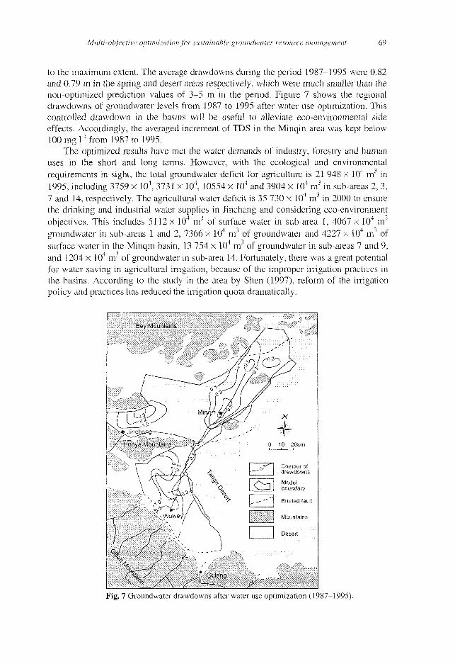
to the maximum extent. The average drawdowns during the period 1987-1995 were 0.82 and 0.79 m in the spring and desert areas respectively, which were much smaller than the non-optimized prediction values of 3-5 m in the period. Figure 7 shows the regional drawdowns of groundwater levels from 1987 to 1995 after water use optimization. This controlled drawdown in the basins will be useful to alleviate eco-environmental side effects. Accordingly, the averaged increment of TDS in the Minqin area was kept below 100 rngf1 from 1987 to 1995.
The optimized results have met the water demands of industry, forestry and human uses in the short and long terms. However, with the ecological and environmental requirements in sight, the total groundwater deficit for agriculture is 21 948 x 104 nr1 in 1995, including 3759 x 104, 3731 x 104, 10554 x 104 and 3904 x 104 m3 in sub-areas 2, 3, 7 and 14, respectively. The agricultural water deficit is 35 730 x 10 nr' in 2000 to ensure the drinking and industrial water supplies in Jinchang and considering eco-environment objectives. This includes 5112 x 104 nr1 of surface water in sub-area 1, 4067 x 104 nr1
groundwater in sub-areas 1 and 2, 7366 x 104 mJ of groundwater and 4227 x 104 mJ of surface water in the Minqin basin, 13 754 x 104 nr' of groundwater in sub-areas 7 and 9, and 1204 x 104 mJ of groundwater in sub-area 14. Fortunately, there was a great potential for water saving in agricultural irrigation, because of the improper irrigation practices in the basins. According to the study in the area by Shen (1997), reform of the irrigation policy and practices has reduced the irrigation quota dramatically.
Fig. 7 Groundwater drawdowns after water use optimization (1987-1995).
70 Y. S. Yang et al.
Table 5 Economie values of the water optimization in the basin (xlO4 RMB Yuan).
1995 2000
Economic output: Planned Calculated
226 631 251148 345 800 345 800
Deviation
24 517 0
Investment: Planned
6 989 8 789
Calculated
6 989 8 789
Deviation
0 0
From the economic point of view, the total output value of the industries and agriculture was less than the desired value according to the current plan. The deficit value was 24 517 x 104 RMB Yuan in 1995 (Table 5). It must be pointed out that the economic analysis could be used as a reference in water optimization because of the difficulty in evaluating the social and environmental values of water engineering and the uncertainty of investment and output data acquisition.
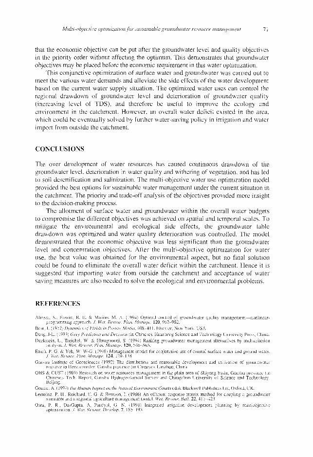
This water optimization considered detailed information on groundwater, surface water and related aspects, but it still could not account for all temporal and spatial variations of the hydrological and geological processes on such a large basin scale. As some coefficients of the equations and the priority order were estimates or predictions, uncertainty may exist in the models. Therefore, a sensitivity analysis was earned out using the groundwater data of 1995 to estimate the reliability of the model, e.g. how the modelling results change when the coefficients or parameters vary. The right-hand side coefficients of the constraint conditions for water level, equations (6)^(8), and solute concentration TDS, equation (9), were calculated. Figure 8 shows the sensitivities of the right-hand side parameters of the groundwater level and concentration constraints in the optimization model. It shows the ranges of each groundwater level and quality parameter that can keep the optimal solution unchanged. The optimal results of optimization could be maintained provided the parameters of groundwater level and quality varied above the curve. Therefore the optimization model remained reliable to model uncertainty provided the economical objective was placed after the water level and quality objectives.
The objectives of the optimization model (Table 2) were to meet the various water demands (P2~Ps), then economic production and investment (Pc,, P7) and groundwater level and quality expectations ÇP8, Pi>) on the basis of the current water availability (P.). To obtain a better trade-off between the conflicting objectives, more detailed constraints were implemented in the multi-objective programming. The sensitivity analysis shows
E
leve
l I
Wat
er
1.5
1.2
0.9
0.6
0.3
0 -i - • — — - r - : • — 7 - : - I 0
0 10 20 30 40 50 60 70 80 90 100
Number of parameters Fig. 8 Sensitivity analysis of the selected parameters for the optimization model.
Multi-objective optimization for sustainable groundwater resource management 71
that the economic objective can be put after the groundwater level and quality objectives in the priority order without affecting the optimum. This demonstrates that groundwater objectives may be placed before the economic requirement in this water optimization.
This conjunctive optimization of surface water and groundwater was carried out to meet the various water demands and alleviate the side effects of the water development based on the current water supply situation. The optimized water uses can control the regional drawdown of groundwater level and deterioration of groundwater quality (increasing level of TDS), and therefore be useful to improve the ecology and environment in the catchment. However, an overall water deficit existed in the area, which could be eventually solved by further water-saving policy in irrigation and water import from outside the catchment.
CONCLUSIONS
The over development of water resources has caused continuous drawdown of the groundwater level, deterioration in water quality and withering of vegetation, and has led to soil desertification and salinization. The multi-objective water use optimization model provided the best options for sustainable water management under the current situation in the catchment. The priority and trade-off analysis of the objectives provided more insight to the decision-making process.
The allotment of surface water and groundwater within the overall water budgets to compromise the different objectives was achieved on spatial and temporal scales. To mitigate the environmental and ecological side effects, the groundwater table drawdown was optimized and water quality deterioration was controlled. The model demonstrated that the economic objective was less significant than the groundwater level and concentration objectives. After the multi-objective optimization for water use, the best value was obtained for the environmental aspect, but no final solution could be found to eliminate the overall water deficit within the catchment. Hence it is suggested that importing water from outside the catchment and acceptance of water saving measures are also needed to solve the ecological and environmental problems.
REFERENCES
Alircza, S., Howitt, R. E. & Marino, M. A. (1994) Optimal control of groundwater quality management—nonlinear-programming approach../. Wat. Resour. Plan. Manage. 120, 962-982.
Bear, J. (1972) Dynamics of Fluids in Porous Media, 408-411. Elsevier, New York, USA. Deng, J-L- (1993) Grey Prediction and Decision (in Chinese). Huazhong Science and Technology University Press, China. Ducksiein, L., Trcichel, W. & Elmagnouni, S. (1994) Ranking groundwater management alternatives by multicriterion
analysis. J. Wat. Resour. Plan. Manage. 120, 546-565. Emch. P. G. & Yen, W. W-G. (1998) Management model for conjunctive use of coastal surface water and ground water.
J. Wat. Resour. Plan. Manage. 124, 129-138. Ganshu Institute of Geosciences (1992) The distribution and reasonable development and utilization of groundwater
resource in Hersi corridor, Ganshu province (in Chinese). Lanzhou, China. GHS &. CUST (1989) Research on water resources management in the plain area of Shiyang basin, Ganshu province (in
Chinese). Tech. Report, Ganshu Hydrogeological Survey and Changchun University of Science and Technology, Beijing.
Goudie, A. ( 1997) The Human Impact on the Natural Environment (fourth edn). Blackwell Publishers Ltd, Oxford, UK. Lemoine, P. H., Reichard, E. G. & Remson, 1. (1986) An efficient response matrix method for coupling a groundwater
simulator and a regional agriculture management model. Wat. Resour. Bull. 22, 417-423. Onta, P. R., DasGupta, A, Paudyal, G. N. (1991) Integrated irrigation development planning by multiobjcctivc
optimization. J. Wat. Resour. Develop. 7, 185-193.
72 Y. S. Yang et al.
Peralta. R. C , Azarmnia, H. & Takahashi, S. (1991) Embedding and response matrix techniques for maximising steady-state groundwater extraction: computational comparison. Ground Water 29, 357-364.
Rosa. D. J. (1995) Economic analysis of optimal water policy. In: Proc. 22nd Ann. Conf. on Integr. Wat. Res. Plan, in the 21st Century, 739-742. Am. Soc. Civil Engrs.
Shen. Z. (1997) Water saving potential and measures in agricultural irrigation (in Chinese). Hydraulic Science 3, 48-53. Shih, K. R., Yang, H. T., Liang, T. C. & Huang C. L. (1997) Grey system modeling approach to power system yearly peak
load forecasting. Proc. National Sci. Council, Republic of China (Part A): Phys. Set. Engng 21, 445-453. Wilamowsky, Y., Epstein, S. & Dickman, B. (1991) Comments on optimization in multiple-objective linear programming
problems. /. Operat. Res. Soc. 42, 522. Wong, H. S-, Sun, N-Z. & Yen, W. W-G. (1997) Optimization of conjunctive use of surface water and groundwater with
water quality constraints. In: Proc. Ann. Wat. Resour. Plan. Manage. Conf., 408-413. Yang, Y. & Lin, X. (1993) Practical Groundwater Management Model (in Chinese). Northeastern Normal University
Press, Changchun, China. Yang, Y., Lin, X., Zhou, L. & Kalin, R. (1999) Sustainable groundwater management under impacts of urban growth in a
developing country. J. Environ. Manage. Health 10, 18-30. Yen, W. W-G. (1992) Systems analysis in ground-water planning and management. ,/. Wat. Resour. Plan. Manage. 118,
224-237.
Received 23 August 1999; accepted 26 June 2000


![Groundwater Overexploitation and Seawater Intrusion in ... · Seawater intrusion induced by groundwater development is also known in South America [21] and Australia [22]. In Africa,](https://img.pdfslide.net/doc/110x75/5edd2c9ead6a402d66682aa2/groundwater-overexploitation-and-seawater-intrusion-in-seawater-intrusion-induced.jpg)


![Unsustainable use of groundwater resources in … use of groundwater resources in ... subsidence, groundwater overexploitation, Permanent Scatterers ... [1, 2] to detect, map and quantify](https://img.pdfslide.net/doc/110x75/5b2043c07f8b9afb1e8b5673/unsustainable-use-of-groundwater-resources-in-use-of-groundwater-resources-in-.jpg)