Embed Size (px)
Citation preview
ARCTIC
VOL. 57, NO. 3 (SEPTEMBER 2004) P. 247–259
Multidisciplinary Investigations of Alpine Ice Patches in Southwest Yukon, Canada:Paleoenvironmental and Paleobiological Investigations
RICHARD FARNELL,1 P. GREGORY HARE,2 ERIK BLAKE,3 VANDY BOWYER,4 CHARLES SCHWEGER,4
SHEILA GREER5 and RUTH GOTTHARDT2
(Received 25 November 2003; accepted in revised form 27 January 2004)
ABSTRACT. Since the discovery of dung-rich alpine ice patches in southwest Yukon in 1997, continuing multidisciplinarystudies have provided a unique window on the biology, climate, and hunting activity in this region over much of the Holocene.Aerial surveys have identified 72 ice patches of variable size, and 65 patches have been ground-surveyed for organic remains. Ofthese, 35 yielded an abundance of biological specimens, including caribou and other rare large mammal remains, mummified smallmammals and birds, and artifacts spanning 8000 years. The dung provides pollen and plant macrofossils for analysis andpaleoenvironmental reconstruction, as well as dietary, genetic, and parasitic information. Stratigraphically controlled samplingof dung within ice layers has yielded a geochronology placing their formation as early as 8300 to 8000 years BP. Ice patchformation was nearly continuous except for an interval between 6700 and 4700 years BP and another between 1440 and 1030,when warm or dry conditions (or both) resulted in no net ice accumulation. Resumption of ice accumulation over the following500 years likely culminated in the Little Ice Age. The size of the ice patches during this period is made evident by a lichen-freezone that haloes each patch. More recently, interpretation of air photos from 1946 to 2001 has found a significant reduction in icepatch dimensions. Daily temperature records for Whitehorse (1942 –2001) were used to calculate melting degree-day values thataccount for a large part of the variation in ice patch size, indicating that while considerable melting has likely occurred since theend of the Little Ice Age, the ice patches are highly sensitive to decadal changes in temperature.
Key words: Rangifer tarandus, permanent snowfields, climate change, Holocene mammals, Little Ice Age, paleoenvironment,caribou diet, pollen, genetics, parasites
RÉSUMÉ. Depuis la découverte de plaques de glace alpines riches en excréments d’animaux dans le sud-ouest du Yukon en 1997,des études multidisciplinaires continues offrent une fenêtre unique sur la biologie, le climat et les activités de chasse de la régionpendant presque toute la période de l’Holocène. À l’aide de relevés aériens, il a été possible d’identifier 72 plaques de glace detailles différentes. Des relevés sur le terrain ont été effectués sur 65 de ces plaques pour récupérer des restes organiques, et 18d’entre-elles ont révélé une abondance d’espèces biologiques et des restes de grands mammifères rares (y compris le caribou),des petits mammifères et des oiseaux momifiés, et des artéfacts datant jusqu’à 8000 ans. Les excréments d’animaux permettentd’analyser des macrofossiles de pollen et de plantes afin de faire une reconstruction paléoécologique, ainsi que d’obtenir desrenseignements sur le régime alimentaire, la génétique et les parasites. À l’aide de la géochronologie, l’échantillonnage desexcréments d’animaux contrôlé par stratigraphie a permis de dater la formation des excréments à aussi loin que 8300 à 8000 ansB.P. La formation des plaques de glace a été presque continue, à l’exception d’une période entre 6700 et 4700 ans B.P. et d’uneautre entre 1440 et 1030, lorsque des conditions chaudes ou sèches ou les deux n’ont pas permis à la glace de s’accumuler. Lareprise de l’accumulation de glace au cours des 500 dernières années a vraisemblablement provoqué le petit âge glaciaire. La tailledes plaques de glace au cours de cette période est facilement calculable grâce aux zones sans lichen qui encerclent chaque plaque.Des études plus récentes de photos aériennes prises entre 1946 et 2001 ont permis de constater une réduction marquée de la tailledes plaques de glace. Les données des températures quotidiennes de Whitehorse (de 1942 à 2001) ont été utilisées pour calculerla valeur du degré-jour de fonte qui est en grande partie responsable de la variation de la taille des plaques de glace. Ces donnéesindiquent que même si le plus gros de la fonte s’est produit depuis la fin du petit âge glaciaire, les plaques de glace réagissentbeaucoup aux changements de température décennaux.
Mot clés: Rangifer tarandus, champs de neige permanents, changement climatique, mammifères de l’Holocène, petit âgeglaciaire, paléoécologie, régime alimentaire du caribou, pollen, génétique, parasites
Translated by Jean-François Roldan, Bureau of French Language Services, Government of Yukon.
1 Department of Environment, Government of Yukon, Box 2703, Whitehorse, Yukon, Y1A 2C6, Canada; [email protected] Department of Tourism and Culture, Government of Yukon, Box 2703, Whitehorse, Yukon, Y1A 2C6, Canada3 Icefield Instruments Inc., Box 30036, Whitehorse, Yukon Y1A 5M2, Canada4 Department of Anthropology, University of Alberta, Edmonton, Alberta T6G 2H4, Canada5 Champagne and Aishihik First Nations; Canadian Circumpolar Institute, University of Alberta; address: 8441 - 118th Street, Edmonton,
Alberta T6G 1T2, Canada© The Arctic Institute of North America
248 • R. FARNELL et al.
INTRODUCTION
During the warm summer of 1997, extensive deposits ofprehistoric caribou (Rangifer tarandus sp.) dung and asmall fragment of a 4000-year-old hunting dart were col-lected from a melting alpine ice patch in southern YukonTerritory (Kuzyk et al., 1999). Since then, dozens ofYukon ice patches containing organic remains dating tomore than 8000 years BP have been identified. An excep-tional collection of perishable hunting artifacts, mummi-fied small mammals and birds, large mammal bones, antlerand horn, feces of herbivore species, and an abundance ofpaleoenvironmental proxy evidence have been recovered.The abundance of dung associated with the ice patches wasunexpected, as only two herds of woodland caribou, theAishihik herd of 1500 animals and the Ibex herd of 450,occupy the study area at present. A large body of FirstNations oral history indicates, however, that caribou werefar more abundant and widespread as recently as the 1930s(Anne Ned in Cruikshank et al., 1990; elder Jimmy G.Smith in Champagne and Aishihik First Nations OralHistory Files, n.d.). Caribou are known to seek out icepatches during hot weather in summer (June to August)both for thermal regulation and to escape biting insects.Similar behavior in the past may account for the concen-trations of dung pellets in the ice patches and the attractionthat ice patches held for prehistoric hunters.
The ice patch record of extraordinary, well-preservedperishable materials provides a unique window on thebiology, climate, and hunting activity in the southernYukon over much of the Holocene. With this insight, themultidisciplinary Ice Patch Research Project was formedto advance discoveries and research ice patch sites and thematerials they contain. This paper provides an overview ofthe project research; presents preliminary results of radio-carbon geochronology, ice patch formation, paleoenviron-mental reconstructions, and vertebrate biology; anddiscusses future research and its implications. The ethnog-raphy and archaeology of the southern Yukon ice patchesare presented in the following article (see Hare et al., 2004,this volume).
ENVIRONMENTAL SETTING
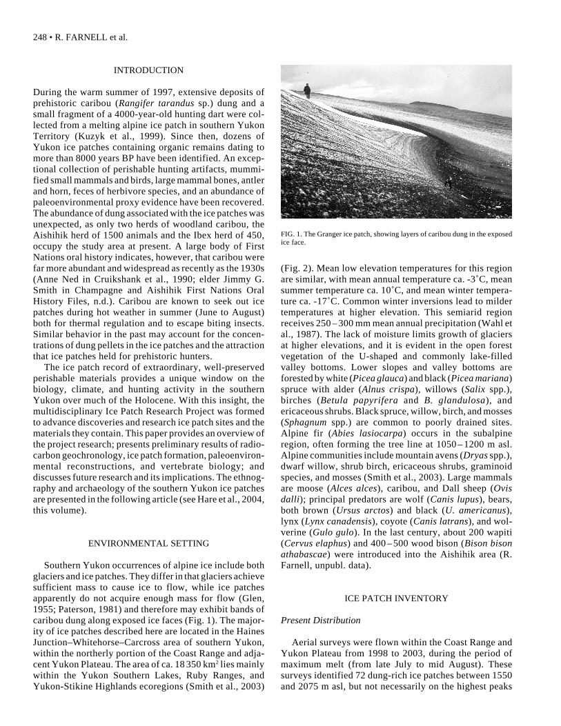
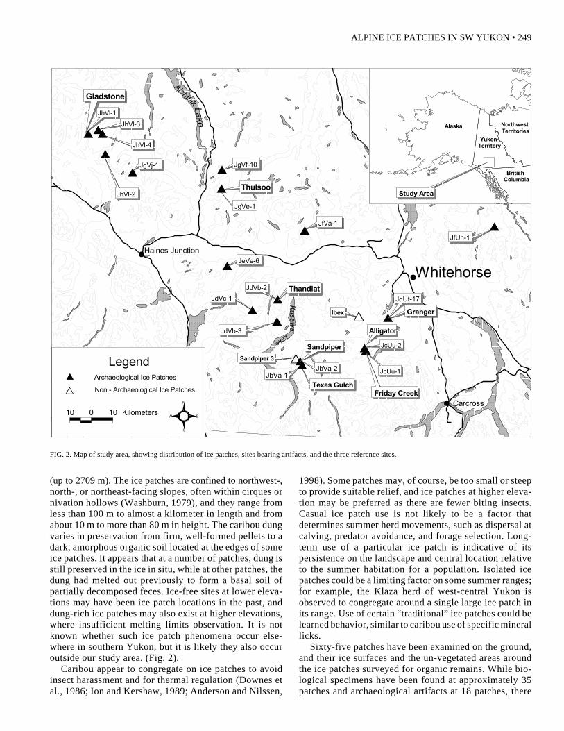
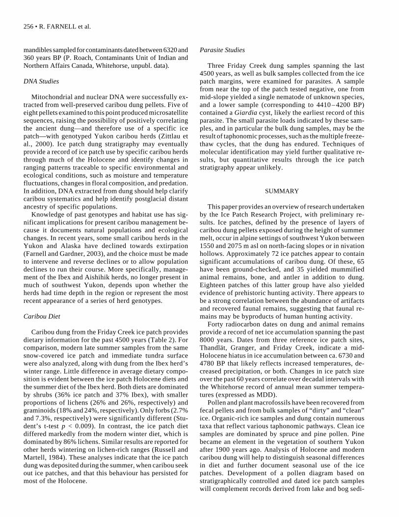
Southern Yukon occurrences of alpine ice include bothglaciers and ice patches. They differ in that glaciers achievesufficient mass to cause ice to flow, while ice patchesapparently do not acquire enough mass for flow (Glen,1955; Paterson, 1981) and therefore may exhibit bands ofcaribou dung along exposed ice faces (Fig. 1). The major-ity of ice patches described here are located in the HainesJunction–Whitehorse–Carcross area of southern Yukon,within the northerly portion of the Coast Range and adja-cent Yukon Plateau. The area of ca. 18 350 km2 lies mainlywithin the Yukon Southern Lakes, Ruby Ranges, andYukon-Stikine Highlands ecoregions (Smith et al., 2003)
(Fig. 2). Mean low elevation temperatures for this regionare similar, with mean annual temperature ca. -3˚C, meansummer temperature ca. 10˚C, and mean winter tempera-ture ca. -17˚C. Common winter inversions lead to mildertemperatures at higher elevation. This semiarid regionreceives 250 – 300 mm mean annual precipitation (Wahl etal., 1987). The lack of moisture limits growth of glaciersat higher elevations, and it is evident in the open forestvegetation of the U-shaped and commonly lake-filledvalley bottoms. Lower slopes and valley bottoms areforested by white (Picea glauca) and black (Picea mariana)spruce with alder (Alnus crispa), willows (Salix spp.),birches (Betula papyrifera and B. glandulosa), andericaceous shrubs. Black spruce, willow, birch, and mosses(Sphagnum spp.) are common to poorly drained sites.Alpine fir (Abies lasiocarpa) occurs in the subalpineregion, often forming the tree line at 1050 – 1200 m asl.Alpine communities include mountain avens (Dryas spp.),dwarf willow, shrub birch, ericaceous shrubs, graminoidspecies, and mosses (Smith et al., 2003). Large mammalsare moose (Alces alces), caribou, and Dall sheep (Ovisdalli); principal predators are wolf (Canis lupus), bears,both brown (Ursus arctos) and black (U. americanus),lynx (Lynx canadensis), coyote (Canis latrans), and wol-verine (Gulo gulo). In the last century, about 200 wapiti(Cervus elaphus) and 400 – 500 wood bison (Bison bisonathabascae) were introduced into the Aishihik area (R.Farnell, unpubl. data).
ICE PATCH INVENTORY
Present Distribution
Aerial surveys were flown within the Coast Range andYukon Plateau from 1998 to 2003, during the period ofmaximum melt (from late July to mid August). Thesesurveys identified 72 dung-rich ice patches between 1550and 2075 m asl, but not necessarily on the highest peaks
FIG. 1. The Granger ice patch, showing layers of caribou dung in the exposedice face.
ALPINE ICE PATCHES IN SW YUKON • 249
#
#
#
$$ $
$
$
$
$$
$$
$$
$
$
$$
$
$
Thulsoo
Thandlat
JgVj-1
JhVl-3
JhVl-4
JgVf-10
JfVa-1
JdVc-1
JeVe-6
JfUn-1
Texas Gulch
Sandpiper
GrangerIbex
Sandpiper 3
JhVl-2
JdVb-3
Haines Junction
Whitehorse
Carcross
JgVe-1
JhVl-1
Gladstone
JdVb-2
T
TJbVa-2
JbVa-1
JdUt-17
Friday Creek
JcUu-1
JcUu-2
Alligator
Kusawa
Lake
Aishihik Lake
Alaska Northwest Territories
British Columbia
Yukon Territory
Study Area
Archaeological Ice Patches$
S
N
EW10 0 10 Kilometers
Non - Archaeological Ice PatchesT
Legend
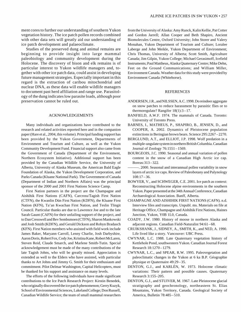
(up to 2709 m). The ice patches are confined to northwest-,north-, or northeast-facing slopes, often within cirques ornivation hollows (Washburn, 1979), and they range fromless than 100 m to almost a kilometer in length and fromabout 10 m to more than 80 m in height. The caribou dungvaries in preservation from firm, well-formed pellets to adark, amorphous organic soil located at the edges of someice patches. It appears that at a number of patches, dung isstill preserved in the ice in situ, while at other patches, thedung had melted out previously to form a basal soil ofpartially decomposed feces. Ice-free sites at lower eleva-tions may have been ice patch locations in the past, anddung-rich ice patches may also exist at higher elevations,where insufficient melting limits observation. It is notknown whether such ice patch phenomena occur else-where in southern Yukon, but it is likely they also occuroutside our study area. (Fig. 2).
Caribou appear to congregate on ice patches to avoidinsect harassment and for thermal regulation (Downes etal., 1986; Ion and Kershaw, 1989; Anderson and Nilssen,
1998). Some patches may, of course, be too small or steepto provide suitable relief, and ice patches at higher eleva-tion may be preferred as there are fewer biting insects.Casual ice patch use is not likely to be a factor thatdetermines summer herd movements, such as dispersal atcalving, predator avoidance, and forage selection. Long-term use of a particular ice patch is indicative of itspersistence on the landscape and central location relativeto the summer habitation for a population. Isolated icepatches could be a limiting factor on some summer ranges;for example, the Klaza herd of west-central Yukon isobserved to congregate around a single large ice patch inits range. Use of certain “traditional” ice patches could belearned behavior, similar to caribou use of specific minerallicks.
Sixty-five patches have been examined on the ground,and their ice surfaces and the un-vegetated areas aroundthe ice patches surveyed for organic remains. While bio-logical specimens have been found at approximately 35patches and archaeological artifacts at 18 patches, there
FIG. 2. Map of study area, showing distribution of ice patches, sites bearing artifacts, and the three reference sites.
250 • R. FARNELL et al.
appears to be a strong correlation between the abundanceof artifacts and recovered faunal remains. The most pro-ductive ice patches (named with reference to nearby geo-graphical features) are Thandlät, Thulsoo, Gladstone,Granger, Friday Creek, Alligator, Sandpiper, and TexasGulch (Fig. 2). All but ten prehistoric artifacts were recov-ered from these eight sites. Three sites, the Thandlät,Granger, and Friday Creek ice patches, were selected asreference sites because of their large size and numerousdung-rich layers, and these sites received more detaileddescription and sampling (Table 1). At each of these sites,the dung was preserved in situ.
Field and Laboratory Methods
Ice surface slope angles were measured using a survey-or’s clinometer. Vertical measurements of stratigraphyand sample location were made along the exposed, slopingface of the ice patches. Blocks of clean and dung-rich icewere cut from the ice face with a lubricant-free chain sawand kept frozen until eventual laboratory analysis. Allbiological specimens were stored at -15˚C within hours ofcollection and kept at this temperature until distribution tospecialists. Large mammal material was submitted to D.Balkwill and S. Cumbaa, Canadian Museum of Nature, forspecies identification, and 17 caribou mandibles were sentto the Contaminants Unit, Department of Indian and North-ern Affairs (Canada), for measurement of pre-industrialheavy metal contamination levels. Small mammal and birdmaterial was provided to the University of Alaska Mu-seum Frozen Tissue Collection.
AMS 14C dates were determined by University of To-ronto Isotrace Laboratory; Beta Analytic Inc., Miami,Florida; and Lawrence Livermore National Laboratory,University of Southern California. All results are ex-pressed as uncalibrated radiocarbon dates. Pollen andplant macrofossil analysis was performed by V. Bowyer,University of Alberta Laboratory for PaleoenvironmentalStudies. Preparation of organic-rich samples followedstandard methods (Moore et al., 1991); ice samples fol-lowed Bourgeois (2000). Fecal samples from Friday Creekwere particularly easy to collect in volume, and sub-sampleswere submitted to three laboratories. B. Davitt, Washing-ton State University Wildlife Habitat and NutritionLaboratory, performed microhistological diet analysis.
E. Shapiro, Oxford University Ancient Biomolecules Cen-tre, extracted nuclear and mitochondrial DNA. DNA studymethods followed manufacturer’s instructions for theQiaGen DNeasy Stool Kit (QiaGen), and to confirm au-thenticity of the extracted DNA, 250 – 300 base pairs wereamplified and sequenced as in Barnes et al. (2002).P. Wallis, Hyperion Research Ltd., Medicine Hat, Alberta,undertook parasite research.
ICE PATCH FORMATION ANDPALEOENVIRONMENTAL RECONSTRUCTION
Ice Patch Formation
The black-and-white layering, exposed during the sum-mer melt and clearly visible from a distance, is the mostdistinguishing feature of the ice patches. The discrete andnear-parallel layers of concentrated organic material—mostly caribou dung, but also windblown detritus and rareanimal remains and artifacts—are exposed across the faceof the melting ice slope. These layers, separated by cleanice, incline 5˚–15˚ downslope, intersecting the sloping icesurface (25 – 40˚) at a shallow angle. The difference inslope between the dung layers and the ice surface mayreflect gentler slopes during formation of the ice patchversus steeper slopes during periods of melting (as atpresent). Net accumulation of winter snow followed bycompaction and regelation of summer melt formed the icepatches. Broadly, only about 100 layers are observed atany one site, and they are known to pinch out or merge.This, along with 14C dates (discussed below), indicates thatthe layers of dung and detritus are not annual, but concen-trations of organic material deposited on the ice patchsurface over decades or centuries and then concentratedduring melt periods into “super layers.”
The lack of distortion in even the oldest layers and in theshape of the dung pellets, as well as broad agreementbetween stratigraphic levels and 14C dates, indicates thatlittle internal movement or associated shear has takenplace in the ice patches over time. The maximum overallthickness of the ice patches is estimated to be 30 – 50 m,which is marginal for flow (Glen, 1955). The presence ofundisturbed vegetation beneath the Granger ice patchindicates that the base has not moved. Unfortunately, therelatively warm ice temperatures suggest re-crystalliza-tion of the ice and destruction of any ice crystal deforma-tion needed to demonstrate flow.
Geochronology and Paleoclimate
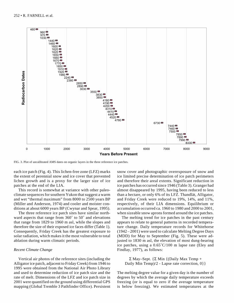
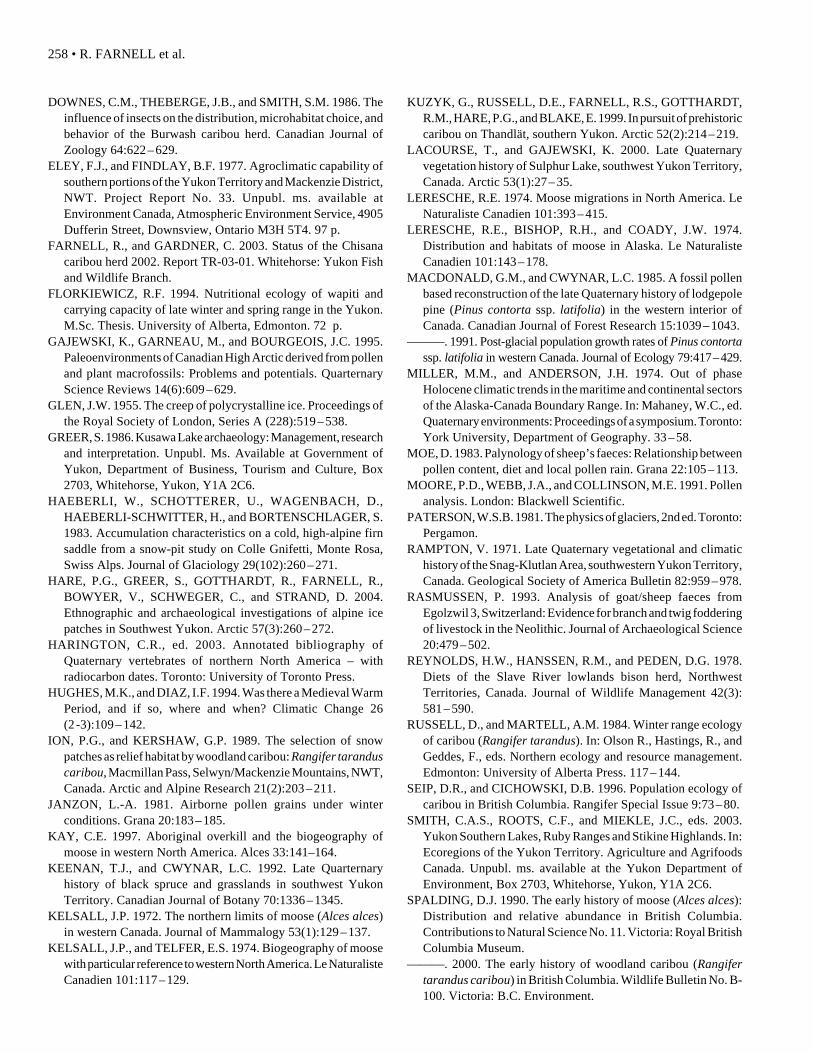
Ice patch geochronology is provided by 42 AMS dateson stratigraphically controlled dung pellets and buriedvegetation (Table 2). Paired dates on separate dung pelletsfrom the same depth indicate the composite nature of thelayers. Even though the majority of dates are in chrono-logical sequence, one cannot rule out deposition and
TABLE 1. Properties of reference ice patches.
Thandlät Granger Friday Creek
Map Coordinates 60˚35'50"N 60˚32'28"N 60˚23'26"N136˚15'18"W 135˚15'25"W 135˚26'30"W
Elevation (m) 1829 1890 1960Aspect 360˚ 40˚ 50˚Length (m) 950 650 720Height (m) 28.2 14.2 88Ice Surface Slope 33.0˚ 37.6˚ 24.7˚
(SD = 4.32) (SD = 1.14) (SD = 0.82)Exposed Surface (m) 28.2 14.2 88.0
ALPINE ICE PATCHES IN SW YUKON • 251
regelation of contaminating organic matter transported bypresent day meltwater along cracks or the organic layers.
Despite the relatively coherent chronologicalstratigraphy demonstrated at the ice patches, temporalgaps are evident. Dates on dung from the base of theGranger ice patch and vegetation beneath the ice patchplace its formation at 8300 to 8000 years BP (Table 2).Dated dung at the base of the Thandlät and Friday Creekice patches places their formation at ca. 7400 years BP and4500 years BP, respectively. Ice patch formation wasnearly continuous except for the interval between 6730and 4780 years BP (Fig. 3). The base of Thandlät dates at7440 ± 60 years BP, while the next date, 3.1 m above, is2890 ± 50 years BP. The temporal gap at Granger, from 2.3to 2.6 m, is between 7500 ± 60 and 4780 ± 80 years BP.Significantly, the basal date at Friday Creek indicatesaccumulation of ice after 4520 ± 50 years BP. These datessuggest that no net ice accumulation occurred over a mid-Holocene interval of 1950 years, or that accumulated icewas condensed during a period of intensive melting. How-ever the lack of evidence for oversteepening of the paleo-ice surface does not support ice reduction.
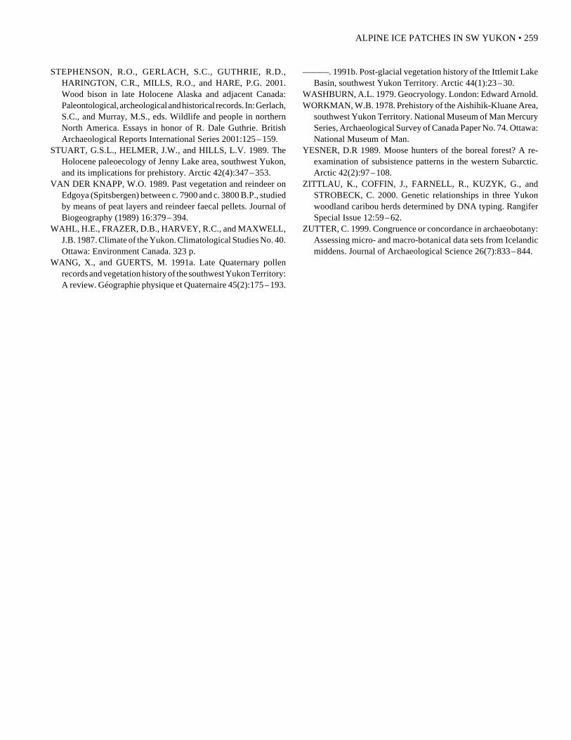
The alpine ice patches reflect the sensitive balancebetween accumulation and ablation, and while mid-Holocene ice may yet be dated, the ice patch recordprovides a paleoclimatic record for southern Yukon. Ac-cumulation of ice at Granger and Thandlät occurred fol-lowing a warmer or drier ice-free interval during the lateglacial, early Holocene (Denton and Karlén, 1973). From6700 to 4700 years BP, increased temperature or reducedprecipitation, or both, resulted in no net ice accumulation.This period was followed by nearly 5000 years of reducedtemperatures or increased precipitation, or both, resultingin significant ice accumulation at all three sites. Accumu-lation over the last 2000 years is especially noticeable andmay broadly correlate to the Neoglaciation (Denton andStuiver, 1967). The interval from 1440 to 1030 BP (AD510 to 920), when we speculate that ice did not accumu-late, falls within the Medieval Warm Period (Hughes andDiaz, 1994). Resumption of ice accumulation over the past1000 years likely culminated in the Little Ice Age (LIA).The size of the ice patches during the LIA is assumed to beshown by the bare, light-coloured rock that forms a haloaround the dark, lichen-covered (Umbilicaria sp.) rock of
TABLE 2. Uncalibrated AMS dates on material recovered in stratigraphic layers in the Granger, Thandlät, and Friday Creek ice patch sites.Stratigraphic distances are measured from the base of each ice patch to the top. Discordant dates were resubmitted for a second analysiswhen fecal material sufficed.
Reference Site Location First Conventional Lab No. Second Conventional Lab No.(m from the base) 14C Date 14C Date
Thandlät 28.2 1850 ± 50 TO-756221.7 0960 ± 50 TO-756014.6 1440 ± 50 TO-755911.6 1670 ± 50 TO-7558
7.2 1620 ± 50 TO-75573.1 2890 ± 50 TO-75560 7440 ± 60 TO-7555
Mount Granger 14.2 0970 ± 50 TO-756311.3 1030 ± 50 TO-756410.3 1600 ± 50 TO-7565 1460 ± 40 Beta-162356
8.6 1920 ± 50 TO-7566 1650 ± 40 Beta-1406197.4 1620 ± 40 Beta-1406216.4 1770 ± 60 TO-7567 1980 ± 40 Beta-1406205.3 1910 ± 60 TO-75684.6 2240 ± 40 Beta-1406223.7 3850 ± 50 Beta-1363603.3 Modern Beta-136359 4180 ± 40 Beta-1406242.9 3030 ± 50 TO-7569 2380 ± 40 Beta-1623552.6 4780 ± 80 Beta-1363582.3 7500 ± 60 Beta-1363571.5 8330 ± 60 Beta-136356 7850 ± 50 Beta-1406230.7 7890 ± 80 Beta-1363550 6730 ± 70 TO-7570 7460 ± 40 Beta-162357
Vegetation 7990 ± 70 Beta-136354
Friday Creek 882 0460 ± 60 Beta-136346771 1650 ± 60 Beta-136347671 1660 ± 50 Beta-136348542 2850 ± 50 Beta-136349401 3550 ± 70 Beta-136350361 3830 ± 40 Beta-152447331 4520 ± 50 Beta-136351 4310 ± 40 Beta-152448
32 4410 ± 50 Beta-136352 4440 ± 40 Beta-15244901 4200 ± 80 Beta-136353 4190 ± 40 Beta-152450
1 Samples used for caribou dietary analysis.2 Samples used for parasite studies.
252 • R. FARNELL et al.
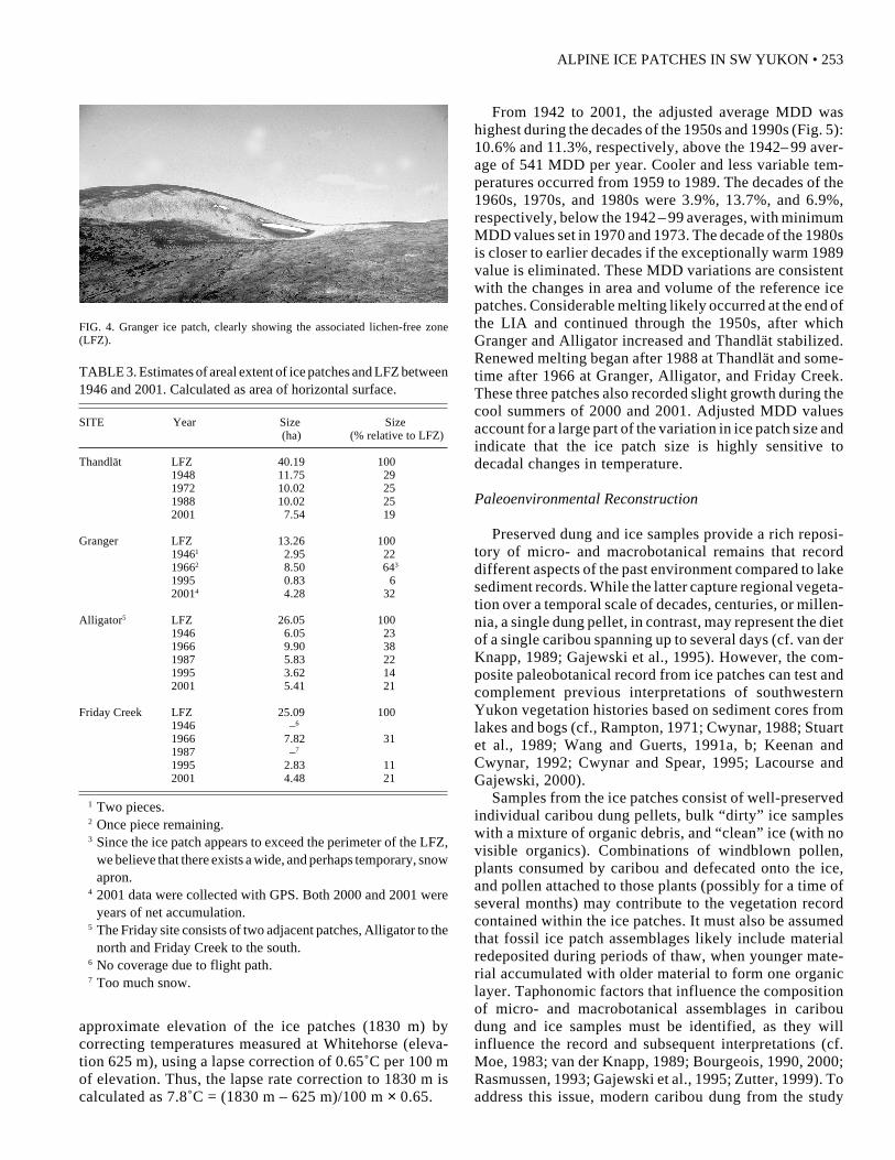
each ice patch (Fig. 4). This lichen-free zone (LFZ) marksthe extent of perennial snow and ice cover that preventedlichen growth and is a proxy for the larger size of icepatches at the end of the LIA.
This record is somewhat at variance with other paleo-climate sequences for southern Yukon that suggest a warmand wet “thermal maximum” from 8000 to 2500 years BP(Miller and Anderson, 1974) and cooler and moister con-ditions at about 6000 years BP (Cwynar and Spear, 1995).
The three reference ice patch sites have similar north-ward aspects that range from 360˚ to 50˚ and elevationsthat range from 1829 to 1960 m asl, while the slopes andtherefore the size of their exposed ice faces differ (Table 1).Consequently, Friday Creek has the greatest exposure tosolar radiation, which makes it the most vulnerable to totalablation during warm climatic periods.
Recent Climate Change
Vertical air photos of the reference sites (including theAlligator ice patch, adjacent to Friday Creek) from 1946 to1995 were obtained from the National Air Photo Libraryand used to determine reduction of ice patch size and therate of melt. Dimensions of the LFZ and ice patch size in2001 were quantified on the ground using differential GPSmapping (Global Tremble 3 Pathfinder Office). Persistent
FIG. 3. Plot of uncalibrated AMS dates on organic layers in the three reference ice patches.
snow cover and photographic overexposure of snow andice limited precise determination of ice patch perimetersand therefore their areal extents. Significant reduction inice patches has occurred since 1946 (Table 3). Granger hadalmost disappeared by 1995, having been reduced to lessthan a hectare, or only 6% of its LFZ. Thandlät, Alligator,and Friday Creek were reduced to 19%, 14%, and 11%,respectively, of their LIA dimensions. Equilibrium oraccumulation occurred ca. 1960 to 1980 and 2000 to 2001,when sizeable snow aprons formed around the ice patches.
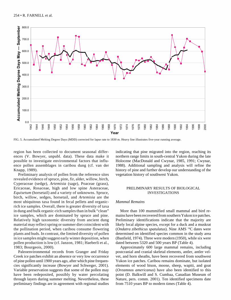
The melting trend for ice patches in the past centuryappears to relate to general patterns in recorded tempera-ture change. Daily temperature records for Whitehorse(1942 – 2001) were used to calculate Melting Degree Days(MDD) for May to September (Fig. 5). These were ad-justed to 1830 m asl, the elevation of most dung-bearingice patches, using a 0.65˚C/100 m lapse rate (Eley andFindlay, 1977), as follows:
Σ May–Sept. {Σ Min {(Daily Max Temp +Daily Min Temp)/2 - Lapse rate correction, 0}}
The melting degree value for a given day is the number ofdegrees by which the average daily temperature exceedsfreezing (or is equal to zero if the average temperatureis below freezing). We estimated temperatures at the
83307990
78907850
750074607440
67304780
452044404410
4310420041904180
38503830
35503030
28902850
23802240
198019201910
18501770
167016601650162016201600
14601440
1030970960
460
0 1000 2000 3000 4000 5000 6000 7000 8000 9000
Years Before Present
Rad
ioca
rbo
n D
ates
ALPINE ICE PATCHES IN SW YUKON • 253
approximate elevation of the ice patches (1830 m) bycorrecting temperatures measured at Whitehorse (eleva-tion 625 m), using a lapse correction of 0.65˚C per 100 mof elevation. Thus, the lapse rate correction to 1830 m iscalculated as 7.8˚C = (1830 m – 625 m)/100 m × 0.65.
From 1942 to 2001, the adjusted average MDD washighest during the decades of the 1950s and 1990s (Fig. 5):10.6% and 11.3%, respectively, above the 1942– 99 aver-age of 541 MDD per year. Cooler and less variable tem-peratures occurred from 1959 to 1989. The decades of the1960s, 1970s, and 1980s were 3.9%, 13.7%, and 6.9%,respectively, below the 1942 – 99 averages, with minimumMDD values set in 1970 and 1973. The decade of the 1980sis closer to earlier decades if the exceptionally warm 1989value is eliminated. These MDD variations are consistentwith the changes in area and volume of the reference icepatches. Considerable melting likely occurred at the end ofthe LIA and continued through the 1950s, after whichGranger and Alligator increased and Thandlät stabilized.Renewed melting began after 1988 at Thandlät and some-time after 1966 at Granger, Alligator, and Friday Creek.These three patches also recorded slight growth during thecool summers of 2000 and 2001. Adjusted MDD valuesaccount for a large part of the variation in ice patch size andindicate that the ice patch size is highly sensitive todecadal changes in temperature.
Paleoenvironmental Reconstruction
Preserved dung and ice samples provide a rich reposi-tory of micro- and macrobotanical remains that recorddifferent aspects of the past environment compared to lakesediment records. While the latter capture regional vegeta-tion over a temporal scale of decades, centuries, or millen-nia, a single dung pellet, in contrast, may represent the dietof a single caribou spanning up to several days (cf. van derKnapp, 1989; Gajewski et al., 1995). However, the com-posite paleobotanical record from ice patches can test andcomplement previous interpretations of southwesternYukon vegetation histories based on sediment cores fromlakes and bogs (cf., Rampton, 1971; Cwynar, 1988; Stuartet al., 1989; Wang and Guerts, 1991a, b; Keenan andCwynar, 1992; Cwynar and Spear, 1995; Lacourse andGajewski, 2000).
Samples from the ice patches consist of well-preservedindividual caribou dung pellets, bulk “dirty” ice sampleswith a mixture of organic debris, and “clean” ice (with novisible organics). Combinations of windblown pollen,plants consumed by caribou and defecated onto the ice,and pollen attached to those plants (possibly for a time ofseveral months) may contribute to the vegetation recordcontained within the ice patches. It must also be assumedthat fossil ice patch assemblages likely include materialredeposited during periods of thaw, when younger mate-rial accumulated with older material to form one organiclayer. Taphonomic factors that influence the compositionof micro- and macrobotanical assemblages in cariboudung and ice samples must be identified, as they willinfluence the record and subsequent interpretations (cf.Moe, 1983; van der Knapp, 1989; Bourgeois, 1990, 2000;Rasmussen, 1993; Gajewski et al., 1995; Zutter, 1999). Toaddress this issue, modern caribou dung from the study
FIG. 4. Granger ice patch, clearly showing the associated lichen-free zone(LFZ).
TABLE 3. Estimates of areal extent of ice patches and LFZ between1946 and 2001. Calculated as area of horizontal surface.
SITE Year Size Size (ha) (% relative to LFZ)
Thandlät LFZ 40.19 1001948 11.75 291972 10.02 251988 10.02 252001 7.54 19
Granger LFZ 13.26 10019461 2.95 2219662 8.50 643
1995 0.83 620014 4.28 32
Alligator5 LFZ 26.05 1001946 6.05 231966 9.90 381987 5.83 221995 3.62 142001 5.41 21
Friday Creek LFZ 25.09 1001946 –6
1966 7.82 311987 –7
1995 2.83 112001 4.48 21
1 Two pieces.2 Once piece remaining.3 Since the ice patch appears to exceed the perimeter of the LFZ,
we believe that there exists a wide, and perhaps temporary, snowapron.
4 2001 data were collected with GPS. Both 2000 and 2001 wereyears of net accumulation.
5 The Friday site consists of two adjacent patches, Alligator to thenorth and Friday Creek to the south.
6 No coverage due to flight path.7 Too much snow.
254 • R. FARNELL et al.
region has been collected to document seasonal differ-ences (V. Bowyer, unpubl. data). These data make itpossible to investigate environmental factors that influ-ence pollen assemblages in caribou dung (cf. van derKnapp, 1989).
Preliminary analysis of pollen from the reference sitesrevealed evidence of spruce, pine, fir, alder, willow, birch,Cyperaceae (sedge), Artemisia (sage), Poaceae (grass),Ericaceae, Rosaceae, high and low spine Asteraceae,Equisetum (horsetail) and a variety of unknowns. Spruce,birch, willow, sedges, horsetail, and Artemisia are themost ubiquitous taxa found in fecal pellets and organic-rich ice samples. Overall, there is greater diversity of taxain dung and bulk organic-rich samples than in bulk “clean”ice samples, which are dominated by spruce and pine.Relatively high taxonomic diversity from ancient dungmaterial may reflect spring or summer diet coincident withthe pollination period, when caribou consume floweringplants and buds. In contrast, the limited diversity of pollenin ice samples might suggest early winter deposition, whenpollen production is low (cf. Janzon, 1981; Haeberli et al.,1983; Bourgeois, 2000).
Paleoenvironmental records from Granger and FridayCreek ice patches exhibit an absence or very low occurrenceof pine pollen until 1900 years ago, after which pine frequen-cies significantly increase (Bowyer and Schweger, 2001).Variable preservation suggests that some of the pollen mayhave been redeposited, possibly by water percolatingthrough layers during summer melting. Nevertheless, thesepreliminary findings are in agreement with regional studies
indicating that pine migrated into the region, reaching itsnorthern range limits in south-central Yukon during the lateHolocene (MacDonald and Cwynar, 1985, 1991; Cwynar,1988). Additional sampling and analysis will refine thehistory of pine and further develop our understanding of thevegetation history of southwest Yukon.
PRELIMINARY RESULTS OF BIOLOGICALINVESTIGATIONS
Mammal Remains
More than 100 mummified small mammal and bird re-mains have been recovered from southern Yukon ice patches.Preliminary identifications indicate that the majority arelikely local alpine species, except for a duck and a muskrat(Ondatra zibethicus spatulatus). Nine AMS 14C dates weredetermined on identified species common in the study area(Banfield, 1974). Three were modern (1950), while six weredated between 5320 and 500 years BP (Table 4).
Approximately 600 large mammal remains, includingpostcranial and cranial skeletal elements, antler, antler vel-vet, and horn sheaths, have been recovered from southwestYukon ice patches. Caribou remains dominate, but isolatedelements of wood bison, moose, sheep, wapiti, and goat(Oreamnos americanus) have also been identified to thispoint (D. Balkwill and S. Cumbaa, Canadian Museum ofNature, pers. comm. 2001). Ten identified specimens datefrom 7510 years BP to modern times (Table 4).
FIG. 5. Accumulated Melting Degree Days (MDD) corrected for lapse rate to 1830 m. Heavy line illustrates five-year running average.
0.0
100.0
200.0
300.0
400.0
500.0
600.0
700.0
800.019
42
1944
1946
1948
1950
1952
1954
1956
1958
1960
1962
1964
1966
1968
1970
1972
1974
1976
1978
1980
1982
1984
1986
1988
1990
1992
1994
1996
1998
2000
Year
Acc
um
ula
ted
Mel
tin
g D
egre
e D
ays
May
— S
epte
mb
er
ALPINE ICE PATCHES IN SW YUKON • 255
Ice patch bison remains are of particular interest towildlife managers following the 1986 successful reintro-duction of wood bison to southwest Yukon. The four icepatch bison dates (Table 4) combined with those (N = 24)from other Yukon sites (Stephenson et al., 2001: Table 1;Harington, 2003) support the widespread occurrence ofthe species in the Yukon through the Holocene to as late as370 BP (Harington, 2003). The occurrence of bison re-mains in ice patches extends the species’ summer habitatuse to high elevations. The extant herd is known to use theuplands from June through August (M. Oakley, YukonDepartment of Environment, unpubl. data), to aggregate inthe immediate vicinity of ice patches and to wallow inancient dung at the Thulsoo ice patch (Fig. 2). Thesefindings point to the cosmopolitan nature of the species,with its ability to exist in upland as well as low-elevationmeadow habitats in the north. Two bison dung samplesfrom Friday Creek, dating 2840 ± 60 and 3500 ± 60 yearsBP, yielded diet composition typical for the average bisondiet (Reynolds et al., 1978): grasses (59.3%), sedges(29.1%), forbs (4.2%), shrubs (2.8%), lichens (3.0%), andmosses (0.9%). Comparing these samples to the composi-tion of modern dung collected from the Yukon herd in2000 and 2001, we found that forbs (2.4%), lichen (4.3%),and moss (2.0%) are correspondingly represented, whileshrubs (7.2%), grasses (24.2%) and sedges (60.1%) weresignificantly different (Student’s t-test p < .01). Continuedmonitoring of the modern bison diet will be important toevaluate the present-day habitat suitability for this onceextirpated species and its long-term significance to otherplant and animal resources.
Wapiti is poorly documented in the Yukon, so its presenceat the Ibex ice patch (Fig. 2) at 2690 ± 40 years BP (Table 4)is important for reconstructing the past large mammal
community. The only other reliably dated occurrence in thestudy area (from an antler found near Whitehorse) is morerecent, dated at 1540 ± 40 years BP. Although wapiti wasreintroduced into southern Yukon in the 1950s, it has notappreciably extended its range or expanded its present num-bers of about 200. Environmental conditions that apparentlyfavoured the animal in the past do not appear to occur in thepresent boreal forest (Florkiewicz, 1994). Present herds re-main largely confined to areas of recent burn and grassy,south-facing slopes.
Mountain goat from the Sandpiper ice patch (dated at2510 ± 40 years BP; Table 4) provides the only date ongoat from the Yukon. Sandpiper is only slightly outside thepresent range of the species (30 km south across KusawaLake) (Fig. 2). The 3570 ± 40 years BP date on sheep fromSandpiper 3 (Table 4) indicates that these two species mayhave been distributed sympatrically in this coastal ecotonearea for the last 2500 years.
A moose humerus from the Sandpiper ice patch datedmodern (Table 4). Other dates (N = 13) place moose in theYukon from mid to late Holocene. For the study area,moose remains from Whitehorse have been dated at 5720± 50 years BP, and those from Aishihik Lake, at 2900 ± 130years BP (Workman, 1978). Moose have expanded inwestern North America since the LIA (Kelsall, 1972;Kelsall and Telfer, 1974; LeResche, 1974; LeResche et al.,1974; Coady, 1980; Yesner, 1989; Spalding, 1990; Kay,1997), coincidentally with apparent decreases in wood-land caribou populations (Seip and Cichowski, 1996;Spaulding, 2000; this study) as forage composition andhabitat areas changed. These changes likely affected preda-tor/prey dynamics as well (Bergerud and Elliot, 1998).
Eighteen non-artifactual caribou elements were dated fromthe ice patches: a scapula dated at 3650 ± 50 BP, and 17
TABLE 4. Species identification and uncalibrated radiometric data for selected small and large mammals.
Specimen Site I.D. Number Lab. Number 14C Date
Lemmus trimucronatus Alligator AF42781 Beta-154425 107.4 ± 0.5 pMCMicrotus oeconomus Marmot AF42780 Beta-154424 109.2 ± 0.5 pMCLemmus trimucronatus Sandpiper AF42761 Beta-154423 109.6 ± 0.5 pMCMicrotus sp. Friday Creek AF32134 Beta-154421 0490 ± 40 BPClethrionomys rutilus Texas Gulch AF32127 Beta-154420 0910 ± 40 BPMicrotus longicaudus Friday Creek AF32105 Beta-154418 1120 ± 40 BPClethrionomys rutilus Friday Creek AF32153 Beta-154422 3220 ± 40 BPLemmus trimucronatus Friday Creek AF32107 Beta-154419 4760 ± 50 BPSpermophilus parryii Alligator YHB-01-35 Beta–162660 3120 ± 50 BPAlces Sandpiper JbVa-2 Beta-164994 121.5 ± 0.6 pMCAlces Whitehorse YHB-01-17 Beta-162883 5720 ± 50 BPOvis dalli Granger YHB-01-60 Beta-165099 0670 ± 40 BPOreamnos americanus Sandpiper YHB-01-31 Beta-164993 2510 ± 40 BPCervus Whitehorse YHB-01-27 Beta- 162358 1540 ± 40 BPCervus Ibex YHB-01-30 Beta-164992 2690 ± 40 BPBison b. Dung Friday Creek YHB-01-56 Beta-165096 2840 ± 60 BPBison b. Dung Friday Creek FRI-99-19 Beta-162359 3500 ± 60 BPOvis dalli Sandpiper 3 YHB-01-58 Beta-165098 3570 ± 40 BPRangifer Friday Creek YHB-01-55 Beta-164995 3650 ± 50 BPBison b. Sandpiper JbVa-2 Beta-152446 4660 ± 40 BPBison b.1 Mt Granger GRA-99-12 Beta-135361 7510 ± 90 BP
1 First reported in Stephenson et al. (2001).
256 • R. FARNELL et al.
mandibles sampled for contaminants dated between 6320 and360 years BP (P. Roach, Contaminants Unit of Indian andNorthern Affairs Canada, Whitehorse, unpubl. data).
DNA Studies
Mitochondrial and nuclear DNA were successfully ex-tracted from well-preserved caribou dung pellets. Five ofeight pellets examined to this point produced microsatellitesequences, raising the possibility of positively correlatingthe ancient dung—and therefore use of a specific icepatch—with genotyped Yukon caribou herds (Zittlau etal., 2000). Ice patch dung stratigraphy may eventuallyprovide a record of ice patch use by specific caribou herdsthrough much of the Holocene and identify changes inranging patterns traceable to specific environmental andecological conditions, such as moisture and temperaturefluctuations, changes in floral composition, and predation.In addition, DNA extracted from dung should help clarifycaribou systematics and help identify postglacial distantancestry of specific populations.
Knowledge of past genotypes and habitat use has sig-nificant implications for present caribou management be-cause it documents natural populations and ecologicalchanges. In recent years, some small caribou herds in theYukon and Alaska have declined towards extirpation(Farnell and Gardner, 2003), and the choice must be madeto intervene and reverse declines or to allow populationdeclines to run their course. More specifically, manage-ment of the Ibex and Aishihik herds, no longer present inmuch of southwest Yukon, depends upon whether theherds had time depth in the region or represent the mostrecent appearance of a series of herd genotypes.
Caribou Diet
Caribou dung from the Friday Creek ice patch providesdietary information for the past 4500 years (Table 2). Forcomparison, modern late summer samples from the samesnow-covered ice patch and immediate tundra surfacewere also analyzed, along with dung from the Ibex herd’swinter range. Little difference in average dietary compo-sition is evident between the ice patch Holocene diets andthe summer diet of the Ibex herd. Both diets are dominatedby shrubs (36% ice patch and 37% Ibex), with smallerproportions of lichens (26% and 26%, respectively) andgraminoids (18% and 24%, respectively). Only forbs (2.7%and 7.3%, respectively) were significantly different (Stu-dent’s t-test p < 0.009). In contrast, the ice patch dietdiffered markedly from the modern winter diet, which isdominated by 86% lichens. Similar results are reported forother herds wintering on lichen-rich ranges (Russell andMartell, 1984). These analyses indicate that the ice patchdung was deposited during the summer, when caribou seekout ice patches, and that this behaviour has persisted formost of the Holocene.
Parasite Studies
Three Friday Creek dung samples spanning the last4500 years, as well as bulk samples collected from the icepatch margins, were examined for parasites. A samplefrom near the top of the patch tested negative, one frommid-slope yielded a single nematode of unknown species,and a lower sample (corresponding to 4410 – 4200 BP)contained a Giardia cyst, likely the earliest record of thisparasite. The small parasite loads indicated by these sam-ples, and in particular the bulk dung samples, may be theresult of taphonomic processes, such as the multiple freeze-thaw cycles, that the dung has endured. Techniques ofmolecular identification may yield further qualitative re-sults, but quantitative results through the ice patchstratigraphy appear unlikely.
SUMMARY
This paper provides an overview of research undertakenby the Ice Patch Research Project, with preliminary re-sults. Ice patches, defined by the presence of layers ofcaribou dung pellets exposed during the height of summermelt, occur in alpine settings of southwest Yukon between1550 and 2075 m asl on north-facing slopes or in nivationhollows. Approximately 72 ice patches appear to containsignificant accumulations of caribou dung. Of these, 65have been ground-checked, and 35 yielded mummifiedanimal remains, bone, and antler in addition to dung.Eighteen patches of this latter group have also yieldedevidence of prehistoric hunting activity. There appears tobe a strong correlation between the abundance of artifactsand recovered faunal remains, suggesting that faunal re-mains may be byproducts of human hunting activity.
Forty radiocarbon dates on dung and animal remainsprovide a record of net ice accumulation spanning the past8000 years. Dates from three reference ice patch sites,Thandlät, Granger, and Friday Creek, indicate a mid-Holocene hiatus in ice accumulation between ca. 6730 and4780 BP that likely reflects increased temperatures, de-creased precipitation, or both. Changes in ice patch sizeover the past 60 years correlate over decadal intervals withthe Whitehorse record of annual mean summer tempera-tures (expressed as MDD).
Pollen and plant macrofossils have been recovered fromfecal pellets and from bulk samples of “dirty” and “clean”ice. Organic-rich ice samples and dung contain numeroustaxa that reflect various taphonomic pathways. Clean icesamples are dominated by spruce and pine pollen. Pinebecame an element in the vegetation of southern Yukonafter 1900 years ago. Analysis of Holocene and moderncaribou dung will help to distinguish seasonal differencesin diet and further document seasonal use of the icepatches. Development of a pollen diagram based onstratigraphically controlled and dated ice patch sampleswill complement records derived from lake and bog sedi-
ALPINE ICE PATCHES IN SW YUKON • 257
ment cores to further our understanding of southern Yukonvegetation history. The ice patch pollen records combinedwith other data sets will greatly aid our understanding ofice patch development and palaeoclimate.
Studies of the preserved dung and animal remains arebeginning to provide insight into large mammalpaleobiology and community development during theHolocene. The discovery of bison and elk remains is ofparticular interest to Yukon wildlife managers and, to-gether with other ice patch data, could assist in developingfuture management strategies. Especially important in thisregard is the extraction of caribou mitochondrial andnuclear DNA, as these data will enable wildlife managersto document past herd affiliation and range use. Parasitol-ogy of the dung indicates low parasite loads, although poorpreservation cannot be ruled out.
ACKNOWLEDGEMENTS
Many individuals and organizations have contributed to theresearch and related activities reported here and in the companionpaper (Hare et al., 2004, this volume). Principal funding support hasbeen provided by the Yukon Government, Departments ofEnvironment and Tourism and Culture, as well as the YukonCommunity Development Fund. Financial support also came fromthe Government of Canada (Department of the Environment,Northern Ecosystem Initiative). Additional support has beenprovided by the Canadian Wildlife Service, the University ofAlberta, University of Alaska Museum, the American Bald EagleFoundation of Alaska, the Yukon Development Corporation, andParks Canada (Kluane National Park). The Government of Canada(Department of Indian and Northern Affairs) was the principalsponsor of the 2000 and 2001 First Nations Science Camp.
First Nation partners in the project are the Champagne andAishihik First Nations (CAFN), Carcross/Tagish First Nation(CTFN), the Kwanlin Dün First Nation (KDFN), the Kluane FirstNation (KFN), Ta’an Kwachan First Nation, and Teslin TlingitCouncil. Particular thanks are due to Lawrence Joe and to the lateSarah Gaunt (CAFN) for their unfailing support of the project, andto Dan Cresswell and Bev Sembsmoen (CTFN), Sharon Mankowskiand Josh Smith (KDFN), and Gerald Dickson and Robyn Bradasch(KFN). First Nation members who assisted with field work includeJames Baker, Maryann Carroll, Lenny Charlie, Josh Darbyshire,Aaron Doris, Robert Fox, Cody Joe, Kristina Kane, Robert McLaren,Steven Reid, Claude Smarch, and Marlene Smith-Tutin. Specialacknowledgement must be made of the many contributions of thelate Tagish Johns, who will be greatly missed. Appreciation isextended as well to the Elders who have assisted, with particularthanks to Art Johns and Jimmy G. Smith for their enthusiasm andcommitment. Pilot Delmar Washington, Capital Helicopters, mustbe thanked for his support and assistance on many levels.
The efforts of the following individuals have made significantcontributions to the Ice Patch Research Project: Kirstin Benedek,who originally discovered the ice patch phenomenon; Gerry Kuzyk,School of Environmental Sciences, Lakeland College; Don Russell,Canadian Wildlife Service; the team of small mammal researchers
from the University of Alaska: Amy Runck, Kalin Kellie, Pat Cotterand Gordon Jarrell; Allan Cooper and Beth Shapiro, AncientBiomolecules Centre, Oxford University; John Storer and ValeryMonahan, Yukon Department of Tourism and Culture; LoraleeLaberge and John Meikle, Yukon Department of Environment;Chris Thomas, University of Alberta; Scott Smith, AgricultureCanada; Jim Gilpin, Yukon College; Michael Gerasimoff, IcefieldInstruments; Paul Mattheus, Alaska Quaternary Centre; Mike Dehn,Feet on the Ground Communications; and William Miller,Environment Canada. Weather data for this study were provided byEnvironment Canada (Whitehorse).
REFERENCES
ANDERSEN, J.R., and NILSSEN, A.C. 1998. Do reindeer aggregateon snow patches to reduce harassment by parasitic flies or tothermoregulate? Rangifer 18(1):3 –17.
BANFIELD, A.W.F. 1974. The mammals of Canada. Toronto:University of Toronto Press.
BARNES, I., MATHEUS, P., SHAPIRO, B., JENSEN, D., andCOOPER, A. 2002. Dynamics of Pleistocene populationextinctions in Beringian brown bears. Science 295:2267 –2270.
BERGLUND, A.T., and ELLIOT, J.P. 1998. Wolf predation in amultiple-ungulate system in northern British Columbia. CanadianJournal of Zoology 76:1551 –1569.
BOURGEOIS, J.C. 1990. Seasonal and annual variation of pollencontent in the snow of a Canadian High Arctic ice cap.Boreas:313 –322.
———. 2000. Seasonal and interannual pollen variability in snowlayers of arctic ice caps. Review of Paleobotany and Palynology108:17 – 36.
BOWYER, V., and SCHWEGER, C.E. 2001. Ice patch as context:Reconstructing Holocene alpine environments in the southernYukon. Paper presented at the 34th Annual Conference, CanadianArchaeological Association. Banff, Alberta.
CHAMPAGNE AND AISHIHIK FIRST NATIONS (CAFN). n.d.Interview files and transcripts. Unpubl. ms. Materials on file atHeritage Office, Champagne and Aishihik First Nations, HainesJunction, Yukon, Y0B 1L0, Canada.
COADY, J.W. 1980. History of moose in northern Alaska andadjacent regions. Canadian Field-Naturalist 94:61 –68.
CRUIKSHANK, J., SIDNEY, A., SMITH, K., and NED, A. 1990.Life lived like a story. Vancouver: UBC Press.
CWYNAR, L.C. 1988. Late Quaternary vegetation history ofKettlehole Pond, southwestern Yukon. Canadian Journal ForestResearch 18:1270 –1279.
CWYNAR, L.C., and SPEAR, R.W. 1995. Paleovegetation andpaleoclimatic changes in the Yukon at 6 ka B.P. Géographiephysique et Quaternaire 49:29 –35.
DENTON, G.J., and KARLÉN, W. 1973. Holocene climaticvariations: Their pattern and possible causes. QuaternaryResearch 3:155–205.
DENTON, G.J., and STUIVER, M. 1967. Late Pleistocene glacialstratigraphy and geochronology, northeastern St. EliasMountains, Yukon Territory, Canada. Geological Society ofAmerica, Bulletin 78:485 –510.
258 • R. FARNELL et al.
DOWNES, C.M., THEBERGE, J.B., and SMITH, S.M. 1986. Theinfluence of insects on the distribution, microhabitat choice, andbehavior of the Burwash caribou herd. Canadian Journal ofZoology 64:622 –629.
ELEY, F.J., and FINDLAY, B.F. 1977. Agroclimatic capability ofsouthern portions of the Yukon Territory and Mackenzie District,NWT. Project Report No. 33. Unpubl. ms. available atEnvironment Canada, Atmospheric Environment Service, 4905Dufferin Street, Downsview, Ontario M3H 5T4. 97 p.
FARNELL, R., and GARDNER, C. 2003. Status of the Chisanacaribou herd 2002. Report TR-03-01. Whitehorse: Yukon Fishand Wildlife Branch.
FLORKIEWICZ, R.F. 1994. Nutritional ecology of wapiti andcarrying capacity of late winter and spring range in the Yukon.M.Sc. Thesis. University of Alberta, Edmonton. 72 p.
GAJEWSKI, K., GARNEAU, M., and BOURGEOIS, J.C. 1995.Paleoenvironments of Canadian High Arctic derived from pollenand plant macrofossils: Problems and potentials. QuarternaryScience Reviews 14(6):609 –629.
GLEN, J.W. 1955. The creep of polycrystalline ice. Proceedings ofthe Royal Society of London, Series A (228):519 –538.
GREER, S. 1986. Kusawa Lake archaeology: Management, researchand interpretation. Unpubl. Ms. Available at Government ofYukon, Department of Business, Tourism and Culture, Box2703, Whitehorse, Yukon, Y1A 2C6.
HAEBERLI, W., SCHOTTERER, U., WAGENBACH, D.,HAEBERLI-SCHWITTER, H., and BORTENSCHLAGER, S.1983. Accumulation characteristics on a cold, high-alpine firnsaddle from a snow-pit study on Colle Gnifetti, Monte Rosa,Swiss Alps. Journal of Glaciology 29(102):260 –271.
HARE, P.G., GREER, S., GOTTHARDT, R., FARNELL, R.,BOWYER, V., SCHWEGER, C., and STRAND, D. 2004.Ethnographic and archaeological investigations of alpine icepatches in Southwest Yukon. Arctic 57(3):260 –272.
HARINGTON, C.R., ed. 2003. Annotated bibliography ofQuaternary vertebrates of northern North America – withradiocarbon dates. Toronto: University of Toronto Press.
HUGHES, M.K., and DIAZ, I.F. 1994. Was there a Medieval WarmPeriod, and if so, where and when? Climatic Change 26(2 -3):109 –142.
ION, P.G., and KERSHAW, G.P. 1989. The selection of snowpatches as relief habitat by woodland caribou: Rangifer taranduscaribou, Macmillan Pass, Selwyn/Mackenzie Mountains, NWT,Canada. Arctic and Alpine Research 21(2):203 –211.
JANZON, L.-A. 1981. Airborne pollen grains under winterconditions. Grana 20:183 –185.
KAY, C.E. 1997. Aboriginal overkill and the biogeography ofmoose in western North America. Alces 33:141–164.
KEENAN, T.J., and CWYNAR, L.C. 1992. Late Quarternaryhistory of black spruce and grasslands in southwest YukonTerritory. Canadian Journal of Botany 70:1336 –1345.
KELSALL, J.P. 1972. The northern limits of moose (Alces alces)in western Canada. Journal of Mammalogy 53(1):129 –137.
KELSALL, J.P., and TELFER, E.S. 1974. Biogeography of moosewith particular reference to western North America. Le NaturalisteCanadien 101:117 –129.
KUZYK, G., RUSSELL, D.E., FARNELL, R.S., GOTTHARDT,R.M., HARE, P.G., and BLAKE, E. 1999. In pursuit of prehistoriccaribou on Thandlät, southern Yukon. Arctic 52(2):214 –219.
LACOURSE, T., and GAJEWSKI, K. 2000. Late Quaternaryvegetation history of Sulphur Lake, southwest Yukon Territory,Canada. Arctic 53(1):27 –35.
LERESCHE, R.E. 1974. Moose migrations in North America. LeNaturaliste Canadien 101:393 – 415.
LERESCHE, R.E., BISHOP, R.H., and COADY, J.W. 1974.Distribution and habitats of moose in Alaska. Le NaturalisteCanadien 101:143 –178.
MACDONALD, G.M., and CWYNAR, L.C. 1985. A fossil pollenbased reconstruction of the late Quaternary history of lodgepolepine (Pinus contorta ssp. latifolia) in the western interior ofCanada. Canadian Journal of Forest Research 15:1039 – 1043.
———. 1991. Post-glacial population growth rates of Pinus contortassp. latifolia in western Canada. Journal of Ecology 79:417–429.
MILLER, M.M., and ANDERSON, J.H. 1974. Out of phaseHolocene climatic trends in the maritime and continental sectorsof the Alaska-Canada Boundary Range. In: Mahaney, W.C., ed.Quaternary environments: Proceedings of a symposium. Toronto:York University, Department of Geography. 33 –58.
MOE, D. 1983. Palynology of sheep’s faeces: Relationship betweenpollen content, diet and local pollen rain. Grana 22:105 –113.
MOORE, P.D., WEBB, J.A., and COLLINSON, M.E. 1991. Pollenanalysis. London: Blackwell Scientific.
PATERSON, W.S.B. 1981. The physics of glaciers, 2nd ed. Toronto:Pergamon.
RAMPTON, V. 1971. Late Quaternary vegetational and climatichistory of the Snag-Klutlan Area, southwestern Yukon Territory,Canada. Geological Society of America Bulletin 82:959 –978.
RASMUSSEN, P. 1993. Analysis of goat/sheep faeces fromEgolzwil 3, Switzerland: Evidence for branch and twig fodderingof livestock in the Neolithic. Journal of Archaeological Science20:479 –502.
REYNOLDS, H.W., HANSSEN, R.M., and PEDEN, D.G. 1978.Diets of the Slave River lowlands bison herd, NorthwestTerritories, Canada. Journal of Wildlife Management 42(3):581 –590.
RUSSELL, D., and MARTELL, A.M. 1984. Winter range ecologyof caribou (Rangifer tarandus). In: Olson R., Hastings, R., andGeddes, F., eds. Northern ecology and resource management.Edmonton: University of Alberta Press. 117 –144.
SEIP, D.R., and CICHOWSKI, D.B. 1996. Population ecology ofcaribou in British Columbia. Rangifer Special Issue 9:73 –80.
SMITH, C.A.S., ROOTS, C.F., and MIEKLE, J.C., eds. 2003.Yukon Southern Lakes, Ruby Ranges and Stikine Highlands. In:Ecoregions of the Yukon Territory. Agriculture and AgrifoodsCanada. Unpubl. ms. available at the Yukon Department ofEnvironment, Box 2703, Whitehorse, Yukon, Y1A 2C6.
SPALDING, D.J. 1990. The early history of moose (Alces alces):Distribution and relative abundance in British Columbia.Contributions to Natural Science No. 11. Victoria: Royal BritishColumbia Museum.
———. 2000. The early history of woodland caribou (Rangifertarandus caribou) in British Columbia. Wildlife Bulletin No. B-100. Victoria: B.C. Environment.
ALPINE ICE PATCHES IN SW YUKON • 259
STEPHENSON, R.O., GERLACH, S.C., GUTHRIE, R.D.,HARINGTON, C.R., MILLS, R.O., and HARE, P.G. 2001.Wood bison in late Holocene Alaska and adjacent Canada:Paleontological, archeological and historical records. In: Gerlach,S.C., and Murray, M.S., eds. Wildlife and people in northernNorth America. Essays in honor of R. Dale Guthrie. BritishArchaeological Reports International Series 2001:125 – 159.
STUART, G.S.L., HELMER, J.W., and HILLS, L.V. 1989. TheHolocene paleoecology of Jenny Lake area, southwest Yukon,and its implications for prehistory. Arctic 42(4):347 –353.
VAN DER KNAPP, W.O. 1989. Past vegetation and reindeer onEdgoya (Spitsbergen) between c. 7900 and c. 3800 B.P., studiedby means of peat layers and reindeer faecal pellets. Journal ofBiogeography (1989) 16:379 –394.
WAHL, H.E., FRAZER, D.B., HARVEY, R.C., and MAXWELL,J.B. 1987. Climate of the Yukon. Climatological Studies No. 40.Ottawa: Environment Canada. 323 p.
WANG, X., and GUERTS, M. 1991a. Late Quaternary pollenrecords and vegetation history of the southwest Yukon Territory:A review. Géographie physique et Quaternaire 45(2):175 –193.
———. 1991b. Post-glacial vegetation history of the Ittlemit LakeBasin, southwest Yukon Territory. Arctic 44(1):23 –30.
WASHBURN, A.L. 1979. Geocryology. London: Edward Arnold.WORKMAN, W.B. 1978. Prehistory of the Aishihik-Kluane Area,
southwest Yukon Territory. National Museum of Man MercurySeries, Archaeological Survey of Canada Paper No. 74. Ottawa:National Museum of Man.
YESNER, D.R 1989. Moose hunters of the boreal forest? A re-examination of subsistence patterns in the western Subarctic.Arctic 42(2):97 –108.
ZITTLAU, K., COFFIN, J., FARNELL, R., KUZYK, G., andSTROBECK, C. 2000. Genetic relationships in three Yukonwoodland caribou herds determined by DNA typing. RangiferSpecial Issue 12:59 –62.
ZUTTER, C. 1999. Congruence or concordance in archaeobotany:Assessing micro- and macro-botanical data sets from Icelandicmiddens. Journal of Archaeological Science 26(7):833 – 844.