Embed Size (px)
Citation preview

p a
r k n
o t
e Lindsay Island and Mulcra IslandMurray Sunset‐ National Park
Visitor GuideLindsay and Mulcra Islands, in the north of Murray‐Sunset National Park, highlight the
Mallee’s relatively untouched earth in a dry climate waiting for the occasional flooding to
bring them to life.
White- plumed‐ Honeyeaters enjoy the many habitats Mulcra Island has to offer – photo: Chris Woods
Enjoying the parkPicnics
Many delightful picnic spots can be found throughout the area.WalkingShort informal bushwalks can be enjoyed long established tracks. Be aware of high summer temperatures.Camping
There are few designated campgrounds, but many of the tracks lead to perfect shady sites along the creeks. Beware of falling River Red Gum limbs when camping. See overleaf for camping guidelines.FishingFish from the water’s edge or launch a small boat on Mullaroo Creek, Lindsay and Murray Rivers. Fish include Golden Perch, Murray Cod, Redfin, Yabbies and the introduced European Carp.
If you are over 18 years of age you must hold a current Victorian Recreation Fishing Licence (RFL). Fishing in the Murray River requires a NSW RFL.
Driving -‐ Two-‐wheel drive vehicle access is on unsealed roads from the Sturt Highway. Four-‐ wheel drive vehicles are recommended for most track and especially the more interior tracks in this remote area.All tracks are dry weather only. Gates onto the islands are closed during floods. Many months of dry access allow you to visit a variety of picturesque locations, including Kulkurna Cliffs and the mouth of the Mullaroo Creek.Canoeing – Excellent canoeing can be enjoyed throughout the islands. Negotiating fallen timber and river bends can be challenging, but the scenery is superb.Birdwatching – The islands have significant populations of both dryland and wetland species. Keep a look out for the elusive Spotted Bowerbird.
Be fire ready and stay safeOn days of forecast Code Red Fire Danger this park will be closed for public safety. If you are already in the park you should leave the night before or early in the morning for your own safety.
Closure signs will be erected and rangers will patrol when possible, however you may not receive a personal warning that the park is closed so check the latest conditions by calling 13 1963 or visit www.parks.vic.gov.au.
For up to date information on fires in Victoria or general fire safety advice call the Victorian Bushfire Information Line on 1800 240 667 or visit www.emergency.vic.gov.au.
For more information call Parks Victoria on 13 1963or visit www.parks.vic.gov.au

f
u
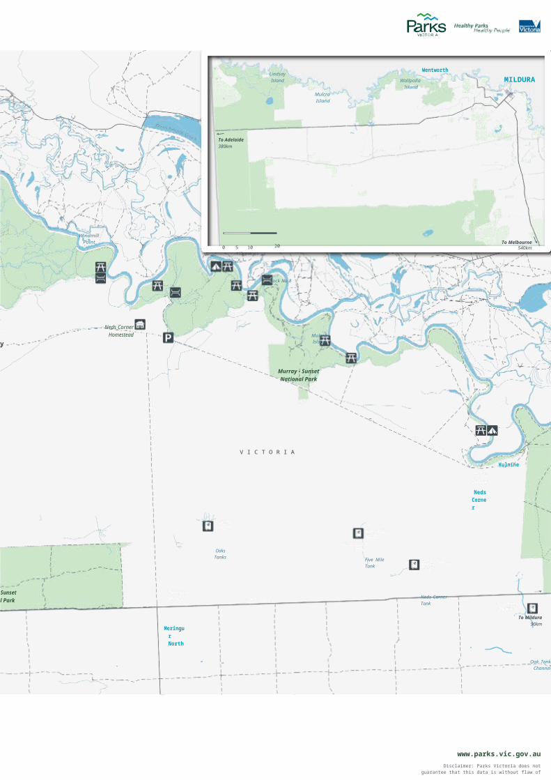
Murray-Sunset National Park - Lindsay Island and Mulcra Island
McCabe Corner
Hancock Hill
N E W
S O U T
H W A L
E S
Higgins Cutting
Ready Island
Bottom Island
Kulkurna Cliffs
PollardsCutting
Cal Lal
Pollards Island
Warrakoo
Toupnein Island
TOUPNEIN CREEK
Devils Elbow
Nampoo Homestead
Lake Victoria
Warpminga Island
Lock No.
Mouth of
LindsayPoint Land
Murray - Sunset National Park
REFERENCE AREA
(No Public Access)
Tourpnein
Websters Lagoon
Websters Island
Private
o
Stoney
Old Yards
the Mullaroo
Lindsay Point State Forest
Lindsay Point
CrankhandleBend
Lindsay Island
Berribee Homestead
Top Island
The
Property
Lindsay Island
CrossingBroken Back
Bridge
Caravan
Lindsa Island
State Forest inMallee Dryland
RegionLindsay
Bridge (closed in time of
flood)
LAKE WALLA WALLA
REFERENCE AREA
(No Public Access)
Berribbee Tanks Lake
Wallawalla (intermittent)
MILLEWA REFERENCE
AREA(No Public Access)
Murray - Sunset National Park
Little Lake
Wallawalla
Murray - Sunset National Park
Murray -Nationa
To Renmark50km

Parking Highway Major river Waterbody
Park/Reserve
Park information Main road Minor river State Forest (Public land)
N Picnic table Sealed road Stream/creek
0 1 2Kilometres
4 Boat ramp Unsealed roadDrinking water 4WD track
Historic site Management vehicle only (MVO)

RUFUSRIVERRD
Lindsay Island
Mulcra Island
WentworthWallpolla
IslandMILDURA
To Adelaide380km
7
Windmill Point
0 5 10Kilometres
To Melbourne20 540km
Lock NNoo.8
Neds Corner
HomesteadMulcra
y Island
Murray - Sunset National Park
V I C T O R I AKulnine
Neds Corner
OaksTanks Five Mile
Tank
Sunset l Park Neds Corner
Tank
Meringur North
To Mildura90km
Oak Tank Channel
www.parks.vic.gov.auP
Disclaimer: Parks Victoria does not guarantee that this data is without flaw of any kind and therefore
disclaims all liability which may arise from you relying on this information.
Data source acknowledgements: State Digital Mapbase. The State of Victoria and the Department of Environment and
Primary Industries.
Cartography by Parks Victoria June 2014For mobile App search for Avenza PDF Maps

HealthHealthyy PParkarkss HealthHealthyy PPeopleeople
For further information Call Parks Victoria on 13 1963 or visit www.parks.vic.gov.au
Mildura Visitor Information (Alfred Deakin Centre) 180- 190‐ Deakin Avenue
Mildura Vic 3500Freecall: 1800 039 043
Tel: (03) 5018 [email protected]
Caring for the environment
Help us look after your park by following these guidelines:
Please take rubbish with you forrecycling or disposal
All plants, animals, historical and archaeological sites and
geographic features are protectedby law
Dogs are not permitted in Murray-‐Sunset National Park
Vehicles, including motor bikes, may only be used on formed
designated roads. Drivers must be licensed and vehicles
registeredand roadworthy
Firearms are prohibited
FireCollect only dead wood from the
ground for campfires No fires are permitted on a day of
Total Fire Ban. Built in and portable gas or electric barbecues
may be used provided:
• the fire is in a properly constructed fireplace or a 30cm deep trench and no more than
one metre in diameter• a 3 metre area is cleared of
anything flammable• at least 10 litres of water is
available for immediate use
• an adult is in attendance atall times
It is your responsibility to know if it is a day of Total Fire Ban.
Murray- Sunset‐ National Park is in the Mallee Total Fire Ban District
Toilets Chemical toilets are preferred. Pit
toilets must be at least 100m from the water’s edge. Bury toilet paper
and waste appropriately
Visiting a park can improve your health, mind, body and
soul. So, with over four million hectares of parkland available to Victorians, why not escape
to a park today!
A rich human historyFor thousands of years Indigenous people were sustained by the rich waters and woodlands of the Murray River’s floodplain. Shell middens, hearths and scar trees found throughout the park reveal much about the lifestyle and rich culture of the people.Early European settlers soon followed the inland watercourse and later the floodplain was grazed by cattle and sheep. The islands were protected when Murray-‐Sunset National Park was established in 1991.
Tree Goannas, also known as Lace Monitors, can grow up to two metres in length
Plants and animalsThe island's floodplains are a haven for wildlife. River Red Gums grow close to the River and along smaller creek beds. Black Box woodlands give way to dense lignum on clay flats -‐ a haven for Robins and Fairy-‐wrens.Pelicans and Wedge-‐tailed Eagles soar overhead while Emus and Red and Western Grey kangaroos roam the drier plains. The elusive, endangered Paucident Planigale, a small native mammal, shelters in clay fissures. Regent Parrots flash through the trees and waterbirds wade in the creeks.
Exploring the Mallee regionThe Victorian Mallee parks cover over one million hectares and are extremely important for nature conservation because of their relatively undisturbed state.
They protect a range of plant and animal species adapted to the dry Mallee environment and contribute significantly to Australia’s biodiversity.
Autumn, winter and spring are the best times to visit.
Environmental WateringEnvironmental regulators have been installed at Lindsay and Mulcra Island to return more natural flooding patterns to nearby water bodies and floodplains. When inundated, these areas provide important refuge and resources for threatened species including habitats for waterbirds and the iconic Murray Cod.
River Red Gums rely on flooding for survival
Location and access
Lindsay Island is about 650km north-‐west of Melbourne and 300km east of Adelaide.
Mulcra Island is about 630km north-‐west of Melbourne and 330km east of Adelaide.
Access to the islands is via the Sturt Highway from Mildura and South Australia.
June 2014Printed on Australian- made‐ 100% recycled paper