Embed Size (px)
Citation preview
MYANMARButhidaung, Maungdaw, and Rathedaung Townships / Rakhine StateImagery analysis: 25 August 2017 - 20 November 2017 | Published 18 December 2017 | Version 1.1
ComplexEmergency
CE20130326MMR
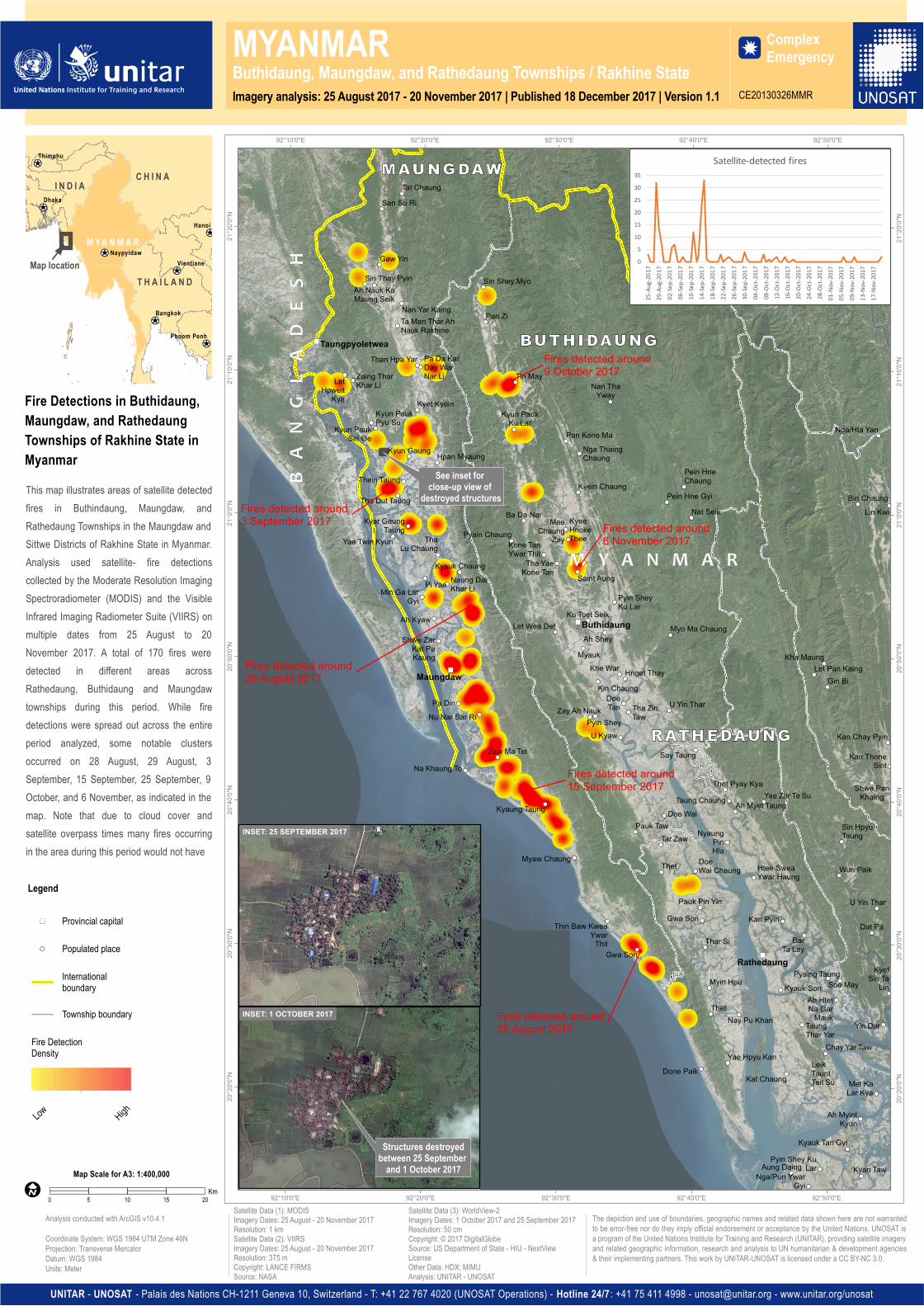
This map illustrates areas of satellite detectedfires in Buthindaung, Maungdaw, andRathedaung Townships in the Maungdaw andSittwe Districts of Rakhine State in Myanmar.Analysis used satellite- fire detectionscollected by the Moderate Resolution ImagingSpectroradiometer (MODIS) and the VisibleInfrared Imaging Radiometer Suite (VIIRS) onmultiple dates from 25 August to 20November 2017. A total of 170 fires weredetected in different areas acrossRathedaung, Buthidaung and Maungdawtownships during this period. While firedetections were spread out across the entireperiod analyzed, some notable clustersoccurred on 28 August, 29 August, 3September, 15 September, 25 September, 9October, and 6 November, as indicated in themap. Note that due to cloud cover andsatellite overpass times many fires occurringin the area during this period would not have
")
")
")
")
Buthidaung
Maungdaw
Taungpyoletwea
Rathedaung
Zaw Ma Tet
Kyaung Taung
Myaw Chaung
Thin Baw KweaYwar
ThitGwa Son
Say Taung
Pauk Taw
KyeeHnokeThee
MeeChaung
Zay
Saint Aung
Pyin SheyKu Lar
Ah Shey
Ku Toet Seik
Myauk
Kin Chaung
Khe War Hnget Thay
Myo Ma Chaung
DoeTan
Pyin SheyZay Ah Nauk
U Kyaw
Tha ZinTaw
U Yin Thar
Pan Zi
Sin Shey Myo
Tin May
Kyun PaukKu Lar
Ba Da Nar
Kyein Chaung
Pan Kone MaNga ThaingChaung
Nan ThaYway
Pein HneChaung
Nat SeikPein Hne Gyi
Kyauk Chaung
Pa DinNu Nar Sar Ri
Na Khaung To
Pyain Chaung
Tha YaeKone Tan
Kone TanYwar Thit
Let Wea Det
Pa Da KarDay WarNar Li
Than Hpa Yar
Kyet Kyein
Kyun Gaung Hpan Myaung
Kyar GaungTaung
ThaLu Chaung
Pi Yae
Shwe ZarKat PaKaung
Naung DarKhar LiMin Ga Lar
Gyi
Ah Kyaw
Tat ChaungSan Su Ri
Gaw Yin
Sin Thay PyinAh Nauk KaMaung Seik
Nan Yar KaingTa Man Thar AhNauk Rakhine
Thein Taung
Tha Dut Taung
Yae Twin Kyun
LetHpweit
Kya
Zaing TharKhar Li
Kyun PaukSin Oe
Kyun PaukPyu Su
Sin HpyuTaungTar Zaw
DoeWai ChaungThet
Pauk Pin YinGwa Son
Thar Si
Myin Hpu
ThetNay Pu Khan
Yae Hpyu KanDone Paik
NyaungPinHla
Htee SweaYwar Haung
Doe Wai
Gin BiLet Pan Kaing
Kha Maung
Kan Chay Pyin
Kan ThoneSint
Shwe PanKhaingTaung Chaung
Thet Pyay Kya
Ah Myet TaungYae Zar Te Su
Bin Chaung
Nga/Hta Yan
Lin Kwi
Met KaLar Kya
U Yin Thar
Dat Pa
KyetSin Ta
Lin
Yin Dar
Pyin Shey KuLarAung Daing
Nga/Pun YwarGyi
Kyauk Tan Gyi
Ah MyintKyun
Kyan Taw
Wun Paik
Pyaing Taung
Kan Pyin
Kyauk Son
BarTa Lay
Soe MayAh HtetNa Gar
MaukTaungThar Yar
Chay Yar Taw
Kat ChaungLeikTauntTeit Su
92°50'0"E
92°50'0"E
92°40'0"E
92°40'0"E
92°30'0"E
92°30'0"E
92°20'0"E
92°20'0"E
92°10'0"E
92°10'0"E
21°2
0'0"N
21°2
0'0"N
21°1
0'0"N
21°1
0'0"N
21°0
'0"N
21°0
'0"N
20°5
0'0"N
20°5
0'0"N
20°4
0'0"N
20°4
0'0"N
20°3
0'0"N
20°3
0'0"N
20°2
0'0"N
20°2
0'0"N
¥¦¬
¥¦¬
¥¦¬
¥¦¬
¥¦¬
¥¦¬
¥¦¬
Dhaka
Hanoi
Thimphu
VientianeNaypyidaw
Bangkok
Phnom Penh
I N D I A C H I N A
T H A I L A N D
M YA N M A R
The depiction and use of boundaries, geographic names and related data shown here are not warrantedto be error-free nor do they imply official endorsement or acceptance by the United Nations. UNOSAT isa program of the United Nations Institute for Training and Research (UNITAR), providing satellite imageryand related geographic information, research and analysis to UN humanitarian & development agencies& their implementing partners. This work by UNITAR-UNOSAT is licensed under a CC BY-NC 3.0.
UNITAR - UNOSAT - Palais des Nations CH-1211 Geneva 10, Switzerland - T: +41 22 767 4020 (UNOSAT Operations) - Hotline 24/7 : +41 75 411 4998 - [email protected] - www.unitar.org/unosat
Fire Detections in Buthidaung,Maungdaw, and RathedaungTownships of Rakhine State inMyanmar
Satellite Data (1): MODISImagery Dates: 25 August - 20 November 2017Resolution: 1 kmSatellite Data (2): VIIRSImagery Dates: 25 August - 20 November 2017Resolution: 375 mCopyright: LANCE FIRMSSource: NASA
Satellite Data (3): WorldView-2Imagery Dates: 1 October 2017 and 25 September 2017Resolution: 50 cmCopyright: © 2017 DigitalGlobeSource: US Department of State - HIU - NextViewLicenseOther Data: HDX; MIMUAnalysis: UNITAR - UNOSAT
Analysis conducted with ArcGIS v10.4.1
Coordinate System: WGS 1984 UTM Zone 46NProjection: Transverse MercatorDatum: WGS 1984Units: Meter
!IMap Scale for A3: 1:400,000
ÆI
Map location
0 5 10 15 20Km
See inset for close-up view of
destroyed structures
Fires detected around 15 September 2017
Fires detected around 9 October 2017
Fires detected around 28 August 2017
Fires detected around 6 November 2017
Fires detected around 3 September 2017
Fires detected around 29 August 2017
Legend
") Provincial capital
Populated place
Internationalboundary
Township boundary
Fire DetectionDensity
Low High
INSET: 1 OCTOBER 2017
05
101520253035
25-Au
g-201
729-
Aug-2
017
02-Sep
-2017
06-Sep
-2017
10-Sep
-2017
14-Sep
-2017
18-Sep
-2017
22-Sep
-2017
26-Sep
-2017
30-Sep
-2017
04-Oc
t-2017
08-Oc
t-2017
12-Oc
t-2017
16-Oc
t-2017
20-Oc
t-2017
24-Oc
t-2017
28-Oc
t-2017
01-No
v-2017
05-No
v-2017
09-No
v-2017
13-No
v-2017
17-No
v-2017
Satellite-detected fires
INSET: 25 SEPTEMBER 2017
Structures destroyedbetween 25 September
and 1 October 2017