Embed Size (px)
Citation preview
MyMaps Mobile and ArcGIS App User Guide
© Sunshine Coast Regional Council 2012 www.sunshinecoast.qld.gov.au [email protected] T 07 5475 7272 F 07 5475 7277 Locked Bag 72 Sunshine Coast Mail Centre Qld 4560 Acknowledgements Council wishes to thank all contributors and stakeholders involved in the development of this document. Disclaimer Information contained in this document is based on available information at the time of writing. All figures and diagrams are indicative only and should be referred to as such. While the Sunshine Coast Regional Council has exercised reasonable care in preparing this document it does not warrant or represent that it is accurate or complete. Council or its officers accept no responsibility for any loss occasioned to any person acting or refraining from acting in reliance upon any material contained in this document.
Contents Spatial Information Management (SIM) ......................................................................4
What We Do...............................................................................................................4
Introduction...................................................................................................................5
Accessing MyMaps via a Desktop Computer ............................................................5
Accessing MyMaps via a Mobile Device ....................................................................6
MyMaps mobile.............................................................................................................7
MyMaps Mobile and ArcGIS App user guides ...........................................................8
Tips and Tricks .............................................................................................................9
How can I clear browser cookies on my iPhone/iPad? ..............................................9
How can I clear browser cookies on my Android phone? ..........................................9
Feedback .......................................................................................................................9
Page 3 of 10 MyMaps Mobile & ArcGIS App User Guide - July 2012
Spatial Information Management (SIM) What We Do Spatial Information Management (SIM) is a unit within Council’s ICTS Branch providing services to both the Sunshine Coast Community and Council staff.
SIM services include capturing and recording asset and planning information, property ownership, geographical data and other data of a spatial nature.
SIM is comprised of four units:
• Spatial Systems Management
• Geospatial Information Services
• Asset Information Services
• Land Information Services
SIM provides information in a textual, visual and spatial format and includes:
• GeoHUB development and support
• Creation of basic and complex Maps
• Computer Aided Drafting (CAD) and Geographic Information Systems (GIS) desktop support
• Disaster management system
• Spatial analysis
• Maintenance of town planning maps
• Spatial data acquisition and consolidation
• Dial Before You Dig requests
• Asset registration and system support
• Field survey and quality assurance
• Title searches and property certificates
• Maintaining the cadastre and change of ownership
• Street naming and numbering
Page 4 of 10 MyMaps Mobile & ArcGIS App User Guide - July 2012
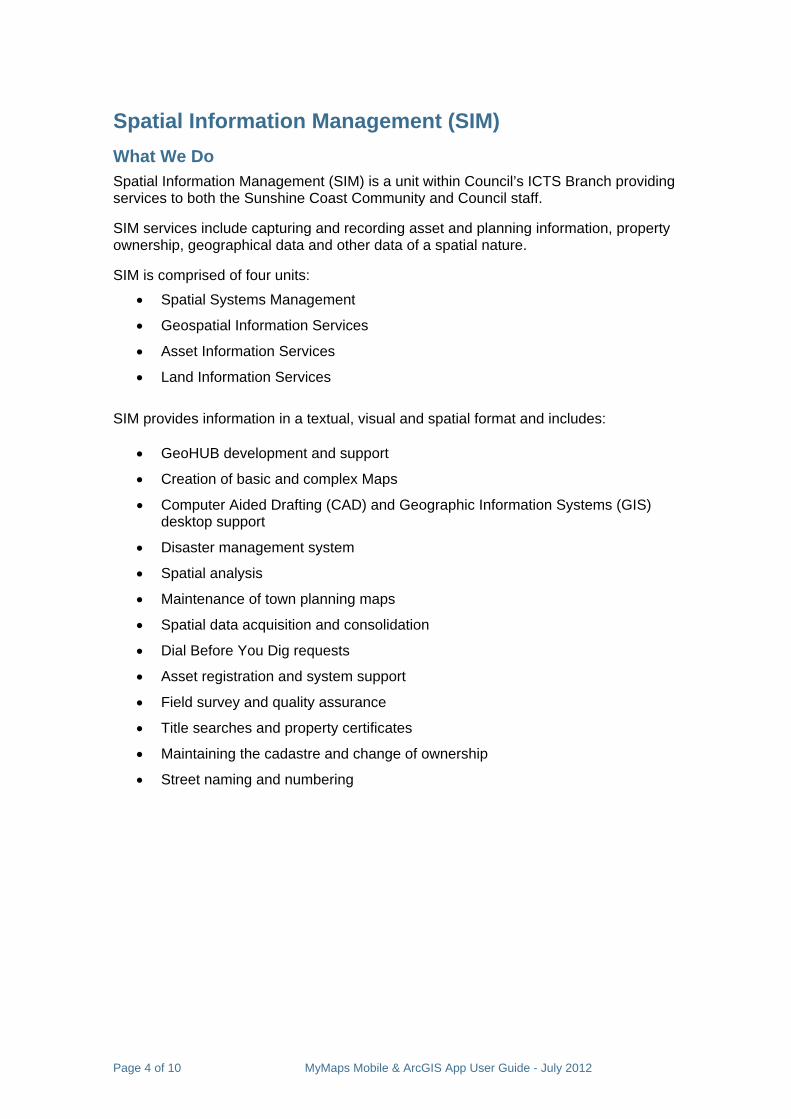
Introduction MyMaps is the Sunshine Coast Council’s regional mapping system and provides the community with quick and easy access to relevant and useful Council information in the form of interactive maps. MyMaps is user friendly and highly interactive, offering up to date information with many useful features.
Access to MyMaps is free and includes information about properties and boundaries, open space and environment areas, water features, planning constraints, population, elevation and aerial photography. MyMaps also includes up to date event information, tourist maps and emergency and flooding maps.
The MyMaps screens are customised into functional groups and contain multiple tools to work with the data. Users can compose a customised map by adding and removing layers, measure features, draw on the map and identify various geographical features.
Accessing MyMaps via a Desktop Computer • You can access MyMaps from the Sunshine Coast Council Internet site at:
www.sunshinecoast.qld.gov.au Then choose Sunshine Coast MyMaps from the Quick Links list or select
Maps from the menu at the top of the page.
• Alternatively type the following address into your internet browser: maps.sunshinecoast.qld.gov.au
Page 5 of 10 MyMaps Mobile & ArcGIS App User Guide - July 2012
Accessing MyMaps via a Mobile Device MyMaps is an interactive environment made with software called Flash Player. Flash is a multimedia platform used to add animation, video, and interactivity to web pages. Unfortunately mobile devices don’t support Flash Player.
If you open a web browser such as Safari on your mobile device and go to maps.sunshinecoast.qld.gov.au you will be automatically redirected to MyMaps view suitable for your mobile device.
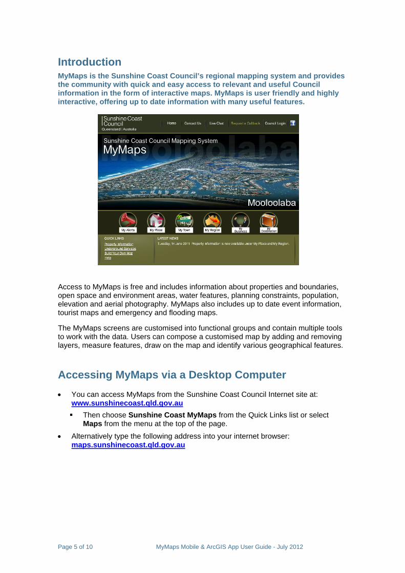
You can also access MyMaps on an iPhone, iPad, Windows phone or Android devices through a free application called ArcGIS. This app is available for a broad range of phones and tablets and is used to view maps and perform simple functions such as measuring distances and areas.
Simply go to the Apple App Store, Android Market (Google Play) or Windows Marketplace on your mobile device and in the search window type “ArcGIS”.
Select the Esri ArcGIS app as shown.
The ArcGIS App extends the reach of geographic information systems from the office to the field. With this app you can access Council produced maps and use tools to search or measure.
Page 6 of 10 MyMaps Mobile & ArcGIS App User Guide - July 2012
MyMaps mobile When you browse to maps.sunshinecoast.qld.gov.au using your mobile device you will be automatically redirected to MyMaps mobile view suitable for your device (iPhone, iPad, Windows phone or Android device)
MyMaps mobile will allow you to view all publicly available maps published by the Sunshine coast council using your mobile device.
As mentioned above, the maps produced by Sunshine coast council are also available through the Esri ArcGIS application.
If you download the Esri ArcGIS application you will be able to use some additional tools such as draw and measure.
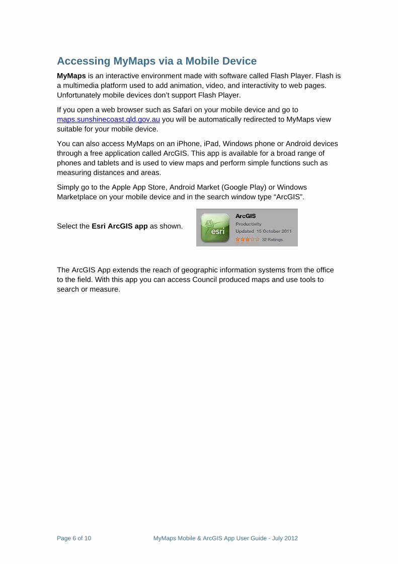
When you fist access MyMaps Mobile the following pop up will appear.
• Select Install to install the free Esri ArcGIS App – you will be redirected to appropriate App store/ Market place/ Google Play
• Select Installed if you already have the Esri ArcGIS App available on your mobile device. If you select this option all maps that you access using MyMaps Mobile will be opened in the Esri ArcGIS application.
• Select Cancel if you do not wish to use the Esri ArcGIS app to view the maps. Please note that if you select this option the pop up will not be displayed in the future.
If you decide to install the ArcGIS application later
Go to the Apple App Store, Android Market (Google Play) or Windows Marketplace on your mobile device and in the search window type “ArcGIS”. Then Select the free Esri ArcGIS app and install it.
Once the application is installed you will be able to: o search for and view MyMaps using the ArcGIS App o access maps using MyMaps Mobile menu and open them using the
ArcGIS App
You will need to confirm that the ArcGIS App has been installed in order to open the maps in ArcGIS App. If you have initially clicked Cancel when prompted to install the ArcGIS application and you wish to display the pop up
again you will need to clear cookies on your mobile device. (See Tips and Tricks on page 9.)
Page 7 of 10 MyMaps Mobile & ArcGIS App User Guide - July 2012
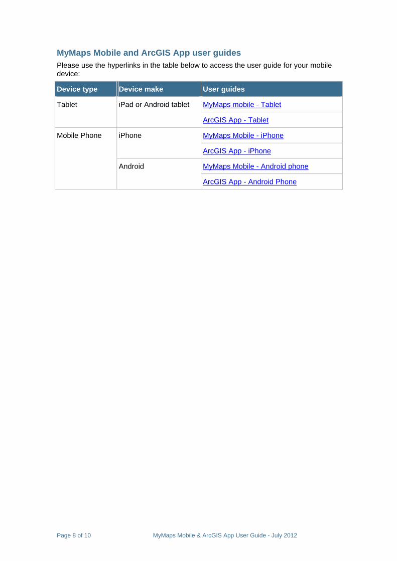
MyMaps Mobile and ArcGIS App user guides Please use the hyperlinks in the table below to access the user guide for your mobile device:
Device type Device make User guides
MyMaps mobile - Tablet Tablet iPad or Android tablet
ArcGIS App - Tablet
MyMaps Mobile - iPhone iPhone
ArcGIS App - iPhone
MyMaps Mobile - Android phone
Mobile Phone
Android
ArcGIS App - Android Phone
Page 8 of 10 MyMaps Mobile & ArcGIS App User Guide - July 2012
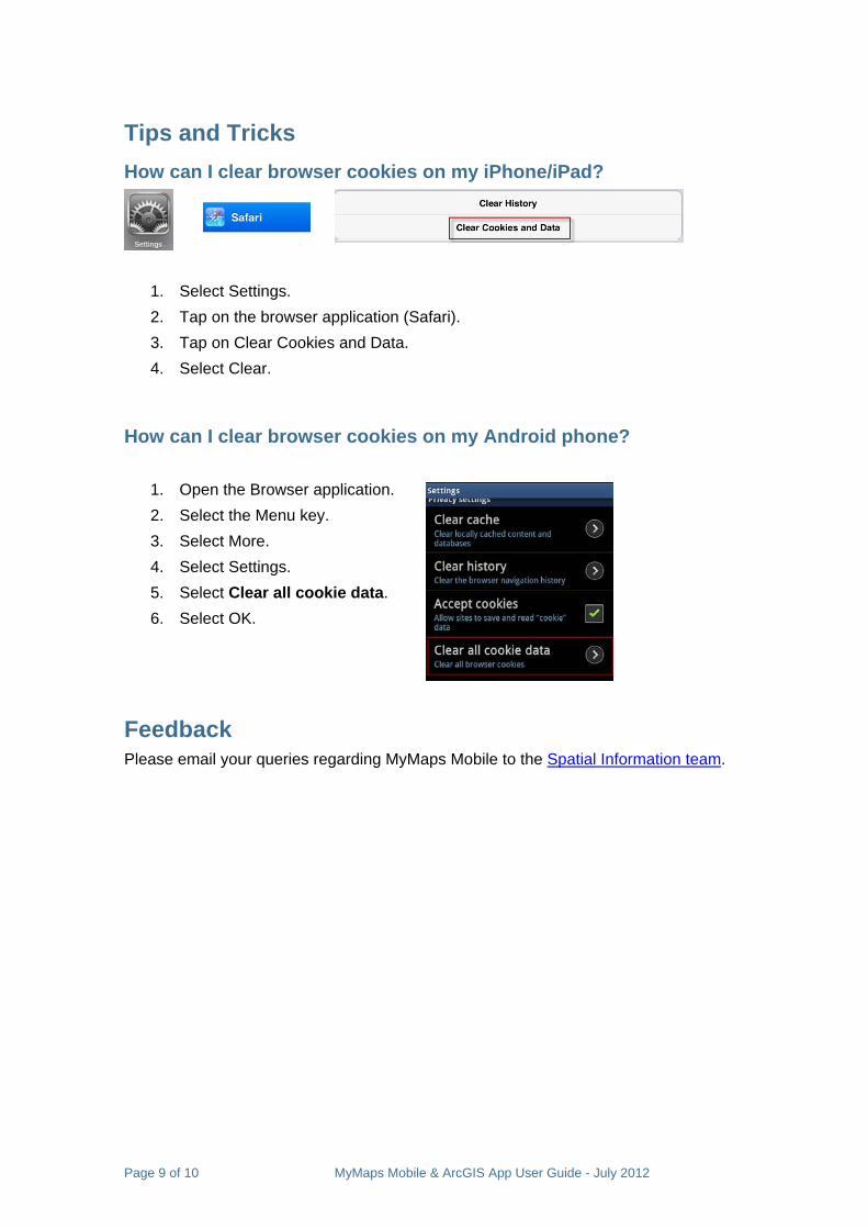
Tips and Tricks How can I clear browser cookies on my iPhone/iPad?
1. Select Settings. 2. Tap on the browser application (Safari). 3. Tap on Clear Cookies and Data. 4. Select Clear.
How can I clear browser cookies on my Android phone?
1. Open the Browser application. 2. Select the Menu key. 3. Select More. 4. Select Settings. 5. Select Clear all cookie data. 6. Select OK.
Feedback Please email your queries regarding MyMaps Mobile to the Spatial Information team.
Page 9 of 10 MyMaps Mobile & ArcGIS App User Guide - July 2012
MyMaps Mobile and ArcGIS App User Guide