Embed Size (px)
Citation preview
HDR Engineering, Inc. 8404 Indian Hills Drive
Omaha, NE 68114-4098 Phone (402) 399-1000 Fax (402) 399-1238 www.hdrinc.com
Page 1 of 3
NN--1122 NNiioobbrraarraa EEaasstt && WWeesstt Memo To: Becky Latka, U.S. Army Corps of Engineers
From: Matt Pillard and Meagan Hall, HDR Engineering, Inc. Project: N-12 Niobrara East & West
CC:
Date: October 16, 2009 Permit No:
2004-10258-WEH
N:\!users\Gail\Stationery & Forms\Forms\memo.doc
RE: Criteria used to determine the limits of construction of the N-12 alternatives
The purpose of this memorandum is to discuss how the Nebraska Department of Roads (NDOR) determined the limits of construction (also called footprints) of each of the N-12 alternatives. The Existing, Parallel, and Base of Bluffs alignment footprints are affected by the elevation raises required to keep the roadway from being overtopped during a flooding event and by the need for rock riprap to be placed on the north sideslope of the new roadway to protect against wave action. The Bluffs and South of Bluffs alignment footprints are affected by the presence of Pierre shale.
The State of Nebraska classifies N-12 as major arterial-intermediate (NDOR, January 15, 1997). Major arterials serve major statewide interests for highway transportation. These roadways link cities, towns, and other traffic generators and form a network with higher systems to provide interstate and inter-county service. Major arterials are characterized by high-speed, relatively long-distance travel patterns (NDOR, July 2006). The minimum design standards for major arterials include a design speed of 60 mph, a minimum 1,200-foot horizontal curve radius, a maximum grade of 4 percent incline/decline, two 12-foot lanes, and two 6-foot shoulders (NDOR, 2008), which would be used west of Niobrara, and 8-foot shoulders would be used east of Niobrara. These design standards apply to all alternatives.
Existing and Parallel alignments – The proposed profile ranges from approximately 6 to 15 feet above the existing highway profile based on a 100-year flood event under the anticipated year 2045 Missouri River conditions and/or potential ice conditions. Construction of the Parallel alignment would result in approximately 813,000 cubic yards of excavated soils are waste (that is, these soils are not suitable for use as fill for the future roadway). Construction of the Existing alignment would result in approximately 265,000 cubic yards of excavated soil waste. Waste materials are usually stock-piled and then hauled off site for disposal. Current bridge and culvert sizing criteria for floodplain connectivity is addressed below. This alternative requires excavation of surface vegetation and soil within the project footprint and requires wave attenuation berms as described below (HWS, March 31, 2009).
Freeboard is the vertical distance between the design water surface elevation and the elevation of the bank that contains the water. The freeboard for a water surface elevation of the Missouri River during a 100-year flood event is 6.33 feet for the west segment and 7.17 feet for the east segment. These freeboards are measured from the edge of the turf shoulder for each segment. They were calculated by subtracting the total shoulder width (6 feet for the west segment and 8 feet for the east segment) from the lateral obstacle clearance (23 feet for the west segment and 30 feet for the east segment), then dividing by 6 (6:1 slope), and then adding 3.5 feet for wave run-up. Again, these freeboard numbers are needed to protect NDOR’s future easement with the Corps, which is that portion of the proposed roadway for each segment that is located between the proposed lateral obstacle clearances, or 35 feet on each side of the project centerline on the west segment, and 42 feet on each side of the project centerline on the east segment (NDOR, April 29, 2009).
HDR Engineering, Inc. 8404 Indian Hills Drive
Omaha, NE 68114-4098 Phone (402) 399-1000 Fax (402) 399-1238 www.hdrinc.com
Page 2 of 3
Base of Bluffs alignment – The proposed profile ranges from approximately 6 to 15 feet above the existing highway profile based on a 100-year flood event under the anticipated 2045 Missouri River conditions and/or potential ice conditions. Existing soil conditions, primarily consisting of saturated and/or soft soils, contribute to excavation waste to be hauled off-site (HWS, March 31, 2009). Approximately 53 percent of excavated soils are waste. Wave attenuation berms would be added as described below.
Bridge and culvert sizing (for floodplain alternatives): In addition to bridge and culvert sizing to meet hydraulic needs, bridges and culverts were sized with consideration of floodplain connectivity for aquatic and terrestrial species. Bridge and culvert sizes to meet hydraulic needs were evaluated with each (as applicable) of the following criteria (as supplied by EPA): 1) burying culverts a minimum of 1 foot; 2) an openness ratio > 0.82 feet; and 3) a vent area ratio of 30 percent. In locations where channels were present, spanning the entire floodplain (or from top of bank to top of bank) was implemented. These criteria, in addition to surrounding land use, wildlife habitat, and water movement, were used for sizing of bridges and culverts as well as for recommendations of new bridge or culvert locations for NDOR’s consideration.
Wave attenuation berm (for the Parallel and Base of Bluffs alignments): NDOR would apply a 30-foot 15:1 wave attenuation berm to those sections where the new highway embankment would be shifted to the south of the existing highway section in the Parallel and Base of Bluffs alignment alternatives. The wave attenuation berm with a vegetative wave break was designed to take advantage of the existing highway embankment where applicable. Where the new highway embankment would be located along (Existing alignment) or located north of (Parallel and Base of Bluffs alignments) the existing highway, a standard 3:1 embankment section would be used with riprap placed along the 3:1 slope of the embankment (see attached cross-section) (NDOR, July 7, 2009).
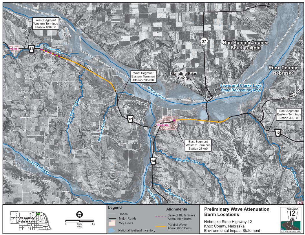
It was preliminarily determined that existing N-12 would be left in place to serve as a wave berm at the following locations (NDOR, August 18, 2009) (see the Preliminary Wave Attenuation Berm Locations figure):
• Alt 1 (Parallel) West Segment – Sta. 455+00 to Sta. 709+50
• Alt 2 (Base of Bluffs) West Segment – Sta. 455+00 to Sta. 517+00
• Alt 1 (Parallel) East Segment – Sta. 33+00 to Sta. 194+00
• Alt 2 (Base of Bluffs) East Segment – Sta. 33+00 to Sta. 39+00
Bluffs and South of Bluffs alignments – Existing soil conditions largely consist of Pierre shale. It is assumed that 40 percent of all material would be waste material not suitable for fill. Embankment and excavation incorporate 4:1 backslopes and foreslopes in areas where Pierre shale is present (HWS, March 31, 2009).
References
HWS. March 31, 2009. Technical Memorandum No. 1. To Don Turek, NDOR, from Justin Mohlmann, HWS.
NDOR. January 15, 1997. Nebraska National Highway Functional Classification. Available online at http://www.dor.state.ne.us/maps/highway/nat-func.pdf.
NDOR. July 2006. Roadway Design Manual. Available online at http://www.nebraskatransportation.org/roadway-design/pdfs/rwydesignman.pdf.
NDOR. 2008. Nebraska Minimum Design Standards: Counties, Municipalities, State. Available online at http://www.dor.state.ne.us/gov-aff/pdfs-docs/MinDesStds.pdf.
HDR Engineering, Inc. 8404 Indian Hills Drive
Omaha, NE 68114-4098 Phone (402) 399-1000 Fax (402) 399-1238 www.hdrinc.com
Page 3 of 3
NDOR. April 29, 2009. Email message from Don Turek, Assistant Design Engineer, NDOR, to Meagan Hall, HDR.
NDOR. July 7, 2009. Memorandum from Robert Carnazzo, Jim Knott, Don Turek, and Kevin Donahoo regarding N-12 wave action protection during future (2045) 100-year flood event.
NDOR. August 19, 2009. Email message from Don Turek, Assistant Design Engineer, NDOR, to Matt Pillard, HDR.

Typicals.dgn 7/7/2009 1:36:57 PM
37
Lewis and Clarke LakeState Recreation Area
Standing Bear Bridge
Bon Homme County,South Dakota
Knox County,Nebraska
Ponca Creek
Dewe
y Cree
k
Niobrara River
Missouri River
Verdigre Creek
Bingham Creek
Burgess Creek
Bazile Creek
Harry
Mille
r Cree
k
Medic
ine C
reek
State Spur 54D
14
12
12
12
West SegmentWestern Terminus
Station 408+00
West SegmentEastern TerminusStation 735+00
East SegmentWestern Terminus
Station 26+00
East SegmentEastern TerminusStation 330+00
Niobrara
Verdel
Knox County,Nebraska Nebraska State Highway 12
Knox County, NebraskaEnvironmental Impact Statement
Preliminary Wave Attenuation Berm Locations
0 1.50.75Miles
Legend
Major Roads
National Wetland Inventory
Roads
City Limits
Base of Bluffs Wave Attenuation Berm
Alignments
Parallel Wave Attenuation Berm