Embed Size (px)
Citation preview
1
Draft Report on SEA by implementing the Management Plan for the Natural and Cultural Heritage in the Ohrid region
2 Civil Engineering Institute “Makedonija” AD Skopje
STRATEGIC ENVIRONMENTAL ASSESSMENT
FOR THE MANAGEMENT PLAN FOR THE
NATURAL AND CULTURAL HERITAGE OF THE
OHRID REGION
Draft Report on SEA by implementing the Management Plan for the Natural and Cultural Heritage in the Ohrid region
3 Civil Engineering Institute “Makedonija” AD Skopje
Preface
During the process of adopting strategic and planning documents, it is mandatory that a report
on the strategic environmental assessment is made. Its purpose is to foresee the possible effects as well as the preventive measures that enable protection of the environment and human health.
This Draft-Strategic Environmental Assessment shall be implemented on the basis of the Agreement between the Civil Engineering Institute “Makedonija” AD Skopje under no. 0902-1790/2 and the Ministry of Culture under no. 46-12124/17 from 17.12.2018, as well as the Annex to the Agreement no. 0905-917/6 from 18.09.2019 (Civil Engineering Institute “Makedonija” AD Skopje) and no.47-10383/1 from 17.09.2019, (Ministry of Culture) for the preparation and making of the Draft Report on the Strategic Environmental Assessment through implementing the Management Plan for the Natural and Cultural Heritage of the Ohrid Region 2018-2027. Since the timeframe of the plan has changed from 2018-2027 to 2019-2028, the Strategic Environmental Assessment shall be made for the Management Plan for the Natural and Cultural Heritage of the Ohrid Region 2019-2028.
The preparation of the report is in accordance with the obligation of the planning document’s
creator to implement the SEA procedure on people’s health and lives, given in chapter X (Impact Assessment to certain environmental strategies, plans and programs) from the Law on Environment.
Pursuant to Point 1, Article 3 of the Decree on Strategies, Plans, and Programs, including changes for which there has been a mandatory impact assessment procedure to both the environment and people’s lives and health, the Management Plan for the Natural and Cultural Heritage of the Ohrid Region for the period of 2019-2028 is a planning document with a mandatory strategic impact assessment. The purpose of this report is to identify and analyse the environmental impact from the implementation of the envisaged planning document in the phase of its preparation and to recommend adequate measures for prevention, control and/or compensation of the impact. In addition, making this SEA shall also be a recommendation arising from the UNESCO Reactive Mission Report in the Ohrid Region in 2017.
The report has been prepared pursuant to the content written in the Decree on the content of the Strategic Environmental Assessment Report (Official Gazette of the Republic of Macedonia no. 153 from 20.12.2007).
People in charge of the preparation of the Startegic Environmental Assesment Report are as
follows:
Martina Blinkova Doncevska, Ecologist, SEA Expert with certificate no.12-770/4 issued by the
MOEPP on 08.02.2017 MSc Suzana Kasovska Georgieva, Archaeologist and Art Historian
Draft Report on SEA by implementing the Management Plan for the Natural and Cultural Heritage in the Ohrid region
4 Civil Engineering Institute “Makedonija” AD Skopje
CONTENT
1. INTRODUCTION ...................................................... ERROR! BOOKMARK NOT DEFINED.
1.1 STRATEGIC ENVIRONMENTAL ASSESSMENT – DEFINITION AND PURPOSE ................................. 10 1.2 COORDINATION BETWEEN THE PLAN AND SEA ........................................................................... 10 1.3 SEA PROCESS ................................................................................................................................. 13
2. CONTENT SUMMARY, MAIN OBJECTIVES AND RISKS OF THE PLANNING DOCUMENT ....................................................................................................................................... 14
2.1 PLANNING DOCUMENT CONTENT REVIEW ................................................................................... 14 2.1.2 CRITERIA FOR LISTING THE OHRID REGION IN THE WORLD HERITAGE LIST ................................ 15 2.1.3 OUTSTANDING UNIVERSAL VALUE ............................................................................................... 15 2.1.4 VALUES ........................................................................................................................................ 15 2.1.5 ZONES AND PROTECTIVE MEASURES WITHIN THE BOUNDARIES OF THE NATURAL AND CULTURAL
HERITAGE OF THE OHRID REGION ........................................................................................................ 17 2.2 PLANNING DOCUMENT’S OBJECTIVES .......................................................................................... 21 2.3 RISKS DEFINED IN THE PLANNING DOCUMENT ........................................................................... 22 2.3.1 ESTABLISHED RISKS AND RECOMMENDATIONS FROM THE UNESCO REACTIVE MISSION REPORT
AND KEY PROVISIONS FROM THE WORLD HEIRTAGE COMMITTEE DECISION (41СОМ 7В.34, REACHED
IN KRAKOW, POLAND JULY 2017) ........................................................................................................ 22 2.3.2 RISKS IN ACCORDANCE WITH THE INTERNATIONAL UNION FOR CONSERVATION OF NATURE
(IUCN) AND THE GLOBAL INTERNATIONAL WATER ASSESMENT (GIWA) .......................................... 24 2.3.3 FACTORS JEOPARDIZING THE CULTURAL HERITAGE AND URBAN ARCHITECTURAL VALUES ...... 36 2.3.4 URBANIZATION AND ILLEGALY CONSTRUCTED OBJECTS ......................................................... 37 2.3.5 INFRASTRUCTURE OBJECTS .......................................................................................................... 40 2.3.6 NEWLY CONSTRUCTED OBJECTS WITHIN THE OLD TOWN NUCLEUS ............................................ 45
3. BASIC DATA ON THE REGION ............................................................................................... 47
3.1 LOCATION ...................................................................................................................................... 47 3.2 AREA BOUNDARIES ........................................................................................................................ 47 3.3 SOCIO-ECONOMIC BASIS ............................................................................................................... 49 3.3.1 BASIC POPULATION CHARACTERISTICS ........................................................................................ 49 3.3.2 URBAN AND SPATIAL PLANNING .................................................................................................. 51 URRBAN PLANS ................................................................................ ERROR! BOOKMARK NOT DEFINED. 3.2 ENVIRONMENTAL STATE ............................................................................................................... 54 3.2.1 RELIEF .......................................................................................................................................... 54 3.2.2 GEOLOGICAL COMPOSITION ......................................................................................................... 54 3.2.3 SEIZMIC CHARACTERISTICS .......................................................................................................... 55 3.2.4 PEDOLOGICAL CHARACTERISTICS ................................................................................................ 55 3.2.5 CLIMATE CHARACTERISTICS ........................................................................................................ 56 3.2.6 HYDROGRPAPHIC AND HYDROBIOLOGICAL CHARACTERISTICS ................................................... 58 3.2.7 STATE OF SITES POSSESSING OUTSTANDING UNIVERSAL VALUE OF NATURAL HERITAGE ........... 62
Draft Report on SEA by implementing the Management Plan for the Natural and Cultural Heritage in the Ohrid region
5 Civil Engineering Institute “Makedonija” AD Skopje
3.2.8 STATE OF SITES POSSESSING OUTSTANDING UNIVERSAL VALUE OF CULTURAL HERITAGE ........ 64 3.3 ENVIRONMENTAL MANAGEMENT ................................................................................................. 71 3.3.1 WATER RESOURCES AND WATER MANAGEMENT ......................................................................... 71 3.3.2 AIR QUALITY MANAGEMENT ........................................................................................................ 72 3.3.3 WASTE MANAGEMENT ................................................................................................................. 73 3.3.4 NOISE MANAGEMENT .................................................................................................................. 74 3.3.5 USE OF LAND ................................................................................................................................ 76 3.3.6 TOURISM ....................................................................................................................................... 77 3.3.7 NATURAL HERITAGE MANAGEMENT ............................................................................................ 78 3.3.8 CULTURAL HERITAGE MANAGEMENT ......................................................................................... 79 3.3.9 NATURAL AND CULTURAL HERITAGE MANEGEMENT COMMITTEE IN THE OHRID REGION .......... 80 4. ENVIRONMENTAL CHARACTERISTICS IN AREAS WHICH COULD BE
SIGNIFICANTLY AFFECTED AND STATE WITHOUT PLAN IMPLEMENTATION ......... 81 3.2.7 STATE OF SITES POSSESSING OUTSTANDING UNIVERSAL VALUE OF CULTURAL HERITAGE ......... 84 5. AREAS OF SIGNIFICANT ENVIRONMENTAL IMPORTANCE REGARDING THE
PROTECTION OF WILD BIRDS AND HABITATS...................................................................... 86 5.1 NATIONAL PROTECTED AREAS ...................................................................................................... 86 5.2 INTERNATIONAL PROTECTED AND PROCLAIMED AREAS ............................................................ 86 5.2.1 ENVIRONMENTAL NETWORKS ...................................................................................................... 87 6. DETERMINING SEA SCOPE ............................................... ERROR! BOOKMARK NOT DEFINED. 6.1 SETTING PLAN’S OBJECTIVES AND CHALLENGES ....................................................................... 93 6.1.1 PLAN’S OBJECTIVES ANALYSIS ..................................................................................................... 94 6.2 SETTING SEA OBJECTIVES ............................................................................................................. 94 6.3 TESTING OF OFFSHORE PARTS REGARDING THE ENVIRONMENTAL OBJECTIVES ..................... 97 6.3.1 COMPARISON BETWEEN THE PLAN AND SEA’S OBJECTIVES ......................................................... 97 6.3.2 PLANNING DOCUMENT ACTION PLAN ......................................................................................... 109 7. ALTERNATIVE SOLUTIONS ANALYSIS .......................... ERROR! BOOKMARK NOT DEFINED. 7.1 INTRODUCTION ............................................................................................................................ 119 7.2 “NO CHNAGES” SCENARIO ........................................................................................................... 119 7.3 ALTERNATIVE SOLUTIONS FOR INFRASTRUCTURE PROJECTS .................................................. 120 7.4 АLTERNATIVE APPROACHES TO PRECISE IDENTIFYING OF THE SO CALLED CONTACT ZONE
BOUNDARIES ...................................................................................................................................... 125 7.4.1 ALTERNATIVE 1: CONTACT ZONE BOUNDARY IDENTICAL TO THE TRANZITION ZONE
BOUNDARY OF THE BIOSPHERE RESERVE OHRID-PRESPA .............................................................. 127 7.4.2 ALTERNATIVE 2: CONTACT ZONE BOUNDARY SMALLER THAN THE CONTACT ZONE OF
BIOSPHERE RESERVE OHRID-PRESPA WITH PRESPA LAKE INCLUDED .......................................... 128 7.4.3 ALTERNATIVE 3: CONTACT ZONE BOUNDARY SMALLER THAN THE CONTACT ZONE OF
BIOSPHERE RESERVE OHRID-PRESPA WITHOUT PRESPA LAKE INCLUDED................................... 129
8. POSSIBLE SIGNIFICANT IMPACTS OF THE PLANNING DOCUMENT ON THE ENVIRONMENT ................................................................. ERROR! BOOKMARK NOT DEFINED.
8.1 IMPACT ON AIR QUALITY ............................................................................................................. 132 8.2 IMPACT ON WATER QUALITY AND QUANTITY ............................................................................ 133 8.3 IMPACT ON SOIL ........................................................................................................................... 134 8.4 IMPACT ON THE AREA .................................................................................................................. 134 8.5 IMPACT ON THE SOCIO-ECONOMIC STATE ................................................................................. 135 8.6 IMPACT ON THE POPULATION AND HUMAN HEALTH ................................................................. 136
Draft Report on SEA by implementing the Management Plan for the Natural and Cultural Heritage in the Ohrid region
6 Civil Engineering Institute “Makedonija” AD Skopje
8.7 IMPACT ON THE CULTURAL HERITAGE ...................................................................................... 136 8.8 IMPACT ON BIODIVERSITY (FLORA AND FAUNA) ....................................................................... 136 8.9 IMPACT RELATED TO WASTE MANAGEMENT ............................................................................. 138 8.10 IMPACT FROM NOISE ................................................................................................................. 139 8.11 CUMULATIVE IMPACT ............................................................................................................... 139 8.12 IMPACTS FROM INCIDENTS AND ACCIDENTS ............................................................................ 139 8.13 TRANS-BOUNDARY IMPACTS ..................................................................................................... 140
9. MEASURES AND RECOMMENDATIONS TO PROTECT, REDUCE, MITIGATE AND NEUTRALIZE THE NEGATIVE IMPACTS ............................................................................... 141
9.1 MEASURES TO PROTECT, REDUCE AND MITIGATE THE NEGATIVE IMPACT ON AIR QUALITY 141 9.2 MEASURES TO PROTECT, REDUCE AND MITIGATE THE NEGATIVE IMPACT ON WATER
QUALITY ............................................................................................................................................. 142 9.3 MEASURES TO PROTECT, REDUCE AND MITIGATE THE NEGATIVE IMPACT ON SOIL .............. 142 9.4 MEASURES TO PROTECT, REDUCE AND MITIGATE THE NEGATIVE IMPACT ON THE AREA ..... 143 9.5 MEASURES TO PROTECT, REDUCE AND MITIGATE THE NEGATIVE IMPACT ON
SOCIOECONOMIC CHARACTERISTICS ............................................................................................... 143 9.6 MEASURES TO PROTECT, REDUCE AND MITIGATE THE NEGATIVE IMPACT ON THE
POPULATION AND HUMAN HEALTH ................................................................................................... 144 9.7 MEASURES TO PROTECT, REDUCE AND MITIGATE THE NEGATIVE IMPACT ON CULTURAL
HERITAGE ......................................................................................... ERROR! BOOKMARK NOT DEFINED. 9.8 MEASURES TO PROTECT, REDUCE AND MITIGATE THE NEGATIVE IMPACT ON BIODIVERSITY
(FLORA AND FAUNA) ........................................................................ ERROR! BOOKMARK NOT DEFINED. 9.9 MEASURES TO PROTECT, REDUCE AND MITIGATE THE NEGATIVE IMPACT OF THE PLANNING
DOCUMENT ON WASTE MANAGEMENT ............................................................................................ 146 9.10 MEASURES TO PROTECT, REDUCE AND MITIGATE THE NEGATIVE IMPACT OF THE PLANNING
DOCUMENT ON NOISE ........................................................................................................................ 147 9.11 MEASURES TO PROTECT, REDUCE AND MITIGATE CUMULATIVE AND TRANSBOUNDARY
IMPACTS ............................................................................................................................................. 147 9.12 MEASURES TO PROTECT, REDUCE AND MITIGATE THE NEGATIVE IMPACT OF INCIDENTS
AND ACCIDENTS ............................................................................... ERROR! BOOKMARK NOT DEFINED.
10. ENVIRONMENTAL MONITORING PLAN .......... ERROR! BOOKMARK NOT DEFINED.
11. NON-TECHNICAL SUMMARY .............................. ERROR! BOOKMARK NOT DEFINED.
12. PUBLIC CONSULTATIONS REPORT .................. ERROR! BOOKMARK NOT DEFINED.
Draft Report on SEA by implementing the Management Plan for the Natural and Cultural Heritage in the Ohrid region
7 Civil Engineering Institute “Makedonija” AD Skopje
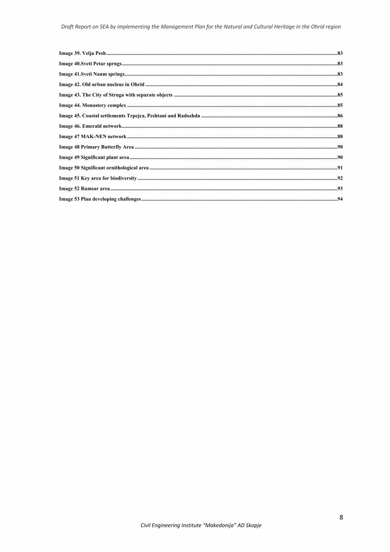
List of images
Image 1. Integration of SEA and Plan processes ...................................................................................................................................11
Image 2. SEA benefits ................................................................................................................................................................................14
Image 3. Outstanding universal value of natural and cultural heritage of the Ohrid Region .........................................................16
Image 4. Protected zones (natural heritage) ...........................................................................................................................................18
Image 5. Protected zones (natural heritage) ............................................................................................................................................19
Image 6. Planning document’s objectives ................................................................................................................................................22
Image 7. Deposition at the estuary of River Sateska and its changes through the years (satellite image from Google
Eartth)……………………………………………………………………………………………………….. 28
Image 8. Water paths from Prespa Lake and rainwaters which flow from Mountain Galicica into Ohrid Lake .......................28
Image 9. Degree of connection between the sewerage network and the collection system (Source: The study on Collecting data
for Improving the Ohrid Lake Environment and Rehabilitation Techniques of the Collection System, DZAJKA, 2015) ...........30
Image 10. Lake when the level is below the minimum allowed natural level (left) and above the maximum allowed natural
level (right) ..................................................................................................................................................................................................32
Image 11.Hydrolofgical modeling of flooding by surface water .........................................................................................................33
Image 12. Hydrological modeling of flooding from underground waters (left) and from the shore, from the lake downstream
(right) ...........................................................................................................................................................................................................33
Image 13. Water paths in Ohrid Lake ....................................................................................................................................................35
Image 14. Inadequate place for a boat to stop in Trpejca ....................................................................................................................36
Image 15. Change of use of land (Source: www.land.copernicus.eu/pan-european/corine-land-cover) .........................................38
Image 16. Threats to UNESCO are from the infrastructure projects ..................................................................................................41
Image 17. Location of Ohrid Region ........................................................................................................................................................47
Image 18. UNESCO boundaries for the protected area ........................................................................................................................48
Image 19. Main hydrological and geological characteristics of Ohrid Lake basin (Haif et al 2011) ................................................54
Image 20. Location of Ohrid Lake in Drim Basin ..................................................................................................................................59
Image 21. Topography of ohrid Lake Basin and highest points ..........................................................................................................60
Image 22. Ohrid Lake ................................................................................................................................................................................62
Image 23. Karst area in Galichica ............................................................................................................................................................62
Image 24. Sites with natural values in the ohrid Region ......................................................................................................................64
Image 25. Sites with cultural values in the ohrid Region .......................................................................................................................65
Image 26. Cultural heritage in the city of Ohrid pursuant the period of occurrence ........................................................................67
Image 27. Old urban nucleus of Ohrid ....................................................................................................................................................68
Image 28. City of Ohrid .............................................................................................................................................................................68
Image 29. City of Struga ............................................................................................................................................................................69
Image 30. Sensor for indicative monitoring of the environmental parameters for air quality in Ohrid .........................................73
Image 31. Noise hotspots in the City of Ohrid ......................................................................................................................................75
Image 32. Use of land in the region ..........................................................................................................................................................77
Image 33. St. Virgin Mary Kalishka ........................................................................................................................................................81
Image 34. Kalishta ......................................................................................................................................................................................82
Image 35. Podmolje ....................................................................................................................................................................................82
Image 36. Mazija ........................................................................................................................................................................................82
Image 37. Studenchishko Blato .................................................................................................................................................................82
Image 38. Veli Dab .....................................................................................................................................................................................83
Draft Report on SEA by implementing the Management Plan for the Natural and Cultural Heritage in the Ohrid region
8 Civil Engineering Institute “Makedonija” AD Skopje
Image 39. Velja Pesh ..................................................................................................................................................................................83
Image 40.Sveti Petar sprngs ......................................................................................................................................................................83
Image 41.Sveti Naum springs ....................................................................................................................................................................83
Image 42. Old urban nucleus in Ohrid ....................................................................................................................................................84
Image 43. The City of Struga with separate objects ..............................................................................................................................85
Image 44. Monastery complex ..................................................................................................................................................................85
Image 45. Coastal settlements Trpejca, Peshtani and Radozhda .........................................................................................................86
Image 46. Emerald network ......................................................................................................................................................................88
Image 47 MAK-NEN network ..................................................................................................................................................................88
Image 48 Primary Butterfly Area ............................................................................................................................................................90
Image 49 Significant plant area ................................................................................................................................................................90
Image 50 Significant ornithological area .................................................................................................................................................91
Image 51 Key area for biodiversity ..........................................................................................................................................................92
Image 52 Ramsar area ...............................................................................................................................................................................93
Image 53 Plan developing challenges .......................................................................................................................................................94
Draft Report on SEA by implementing the Management Plan for the Natural and Cultural Heritage in the Ohrid region
9 Civil Engineering Institute “Makedonija” AD Skopje
LIST OF ABBREVIATIONS/ACRONYMS:
OUV Outstanding universal values GUP General urban plan DUP Detailed urban plan UPOUA Urban plan outside urban area SEA Strategic environment assessment EU European union LEAP Local environmental action plan MOEPP Ministry of Environment and Physical Planning MAFWE Ministry of Agriculture, Forestry and Water Economy MC Ministry of Culture NEAP National environmental action plan SP Spatial plan RNM Republic of North Macedonia GUP General urban plan UP Urban plan UC Urban Community UB Urban block UNESCO United Nations Educational, Scientific and Cultural Organization IUCN International Union for Conservation of Nature HBI Hydro-Biological Institute NP National Park PE Public enterprise LNP Law on Nature Protection NP National Park

Draft Report on SEA by implementing the Management Plan for the Natural and Cultural Heritage in the Ohrid region
10 Civil Engineering Institute “Makedonija” AD Skopje
1. INTRODUCTION
1.1 Strategic Environmental Assessment – Definition and purpose
The Strategic Environemental Assessment (SEA) is a systematic and participatory process implemented so as to analyse the impact on the environment, human life and health as well as on the socio-economic aspects, regarding the implementation of a specific planning document, in this case the “Management Plan for the Natural and Cultural Heritage of the Ohrid Region” (hereinafter referred to as: The Plan).
The SEA procedure integrates environmental issues when making decisions on the scope and methods of the plan implementation. In doing so, the authorities (The Ministry of Culture and The Ministry of Environment and Physical Planning) in charge of the plan implementation, shall, in its review and finalization, take the following into account:
States and trends of environmental areas and activities that may have an impact or be affected by the plan implementation;
Environmental objectives and indicators of the achievement in the plan implementation;
Possible significant environmental effects that may result from the plan implementation;
Measures to avoid, reduce or mitigate the negative impact;
Views, needs and information provided by stakeholders (including competent authorities), in the country and cross-boundary.
1.2 Coordination between the Plan and SEA
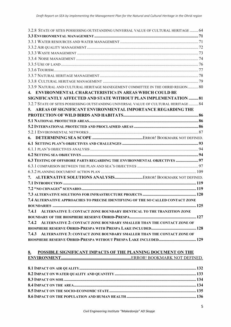
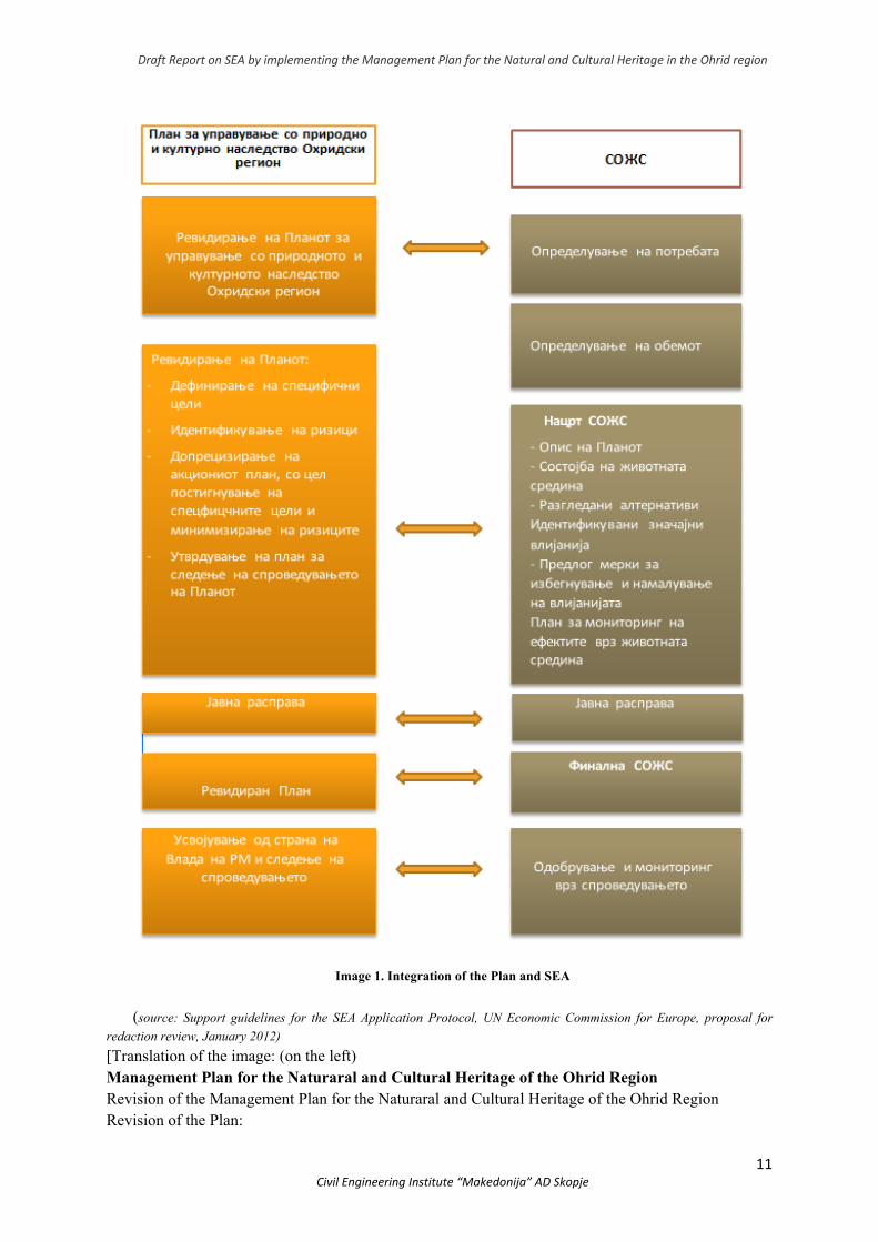
Pursuant ot the Law on Environment (“Official Gazzete of the Republic of Macedonia” no. 53/05, 81/05, 24/07, 159/08, 83/09, 48/10, 124/10, 51/11, 123/12, 93/13, 187/13, 42/14, 44/15, 129/15, 192/15, 39/16 and 99/18) the Strategic Environmental Assesment is done simultaneously with the Plan revision (Image 1). These two processes shall enable adequate integration of the objectives and measures for nature preservation, in order to reduce the impact on the Outstanding Universal Value (OUV) of the Ohrid Region within the Plan. At the same time, the monitoring plans shall comply with the plan implementation and its effect on the environment.
Draft Report on SEA by implementing the Management Plan for the Natural and Cultural Heritage in the Ohrid region
11 Civil Engineering Institute “Makedonija” AD Skopje
Image 1. Integration of the Plan and SEA
(source: Support guidelines for the SEA Application Protocol, UN Economic Commission for Europe, proposal for
redaction review, January 2012)
[Translation of the image: (on the left) Management Plan for the Naturaral and Cultural Heritage of the Ohrid Region Revision of the Management Plan for the Naturaral and Cultural Heritage of the Ohrid Region Revision of the Plan:
Draft Report on SEA by implementing the Management Plan for the Natural and Cultural Heritage in the Ohrid region
12 Civil Engineering Institute “Makedonija” AD Skopje
- Defining specific objectives - Identifying risks - Additional precision of the Action Plan with the purpose of achieving specific goals and
minimization of risks - Establishing a Follow-up Plan for the Plan implementation Public Dispute Revised Plan Adoption by the Government of the Republic of North Macedonia and a follow-up of the implementation (on the right): Strategic Environmental Assesment (SEA) Establishing the need Establishing scope Draft SEA: - Description of the Plan - Environmental state - Reviewed alternatives and identified significant impact - Proposed measures for avoiding and reducing the impact - Environmental Impact Monitoring Plan Public Dispute Final SEA Implementation Adoption and Monitoring
Apart from being a legal obligation, the SEA preparation and making of the Plan, have been initiatied by the Reactive Monitoring Mission by the World Heritage Centre and the Advisory bodies of the Red List of the International Union for Conservation of Nature (IUCN) and the National Committee of the International Council on Monuments and sites (ICOMOS), to a prior appeal by the World Heritage Committee of the UN Educational, Scientific and Cultural Organization (UNESCO) at the 40th session in Istanbul (2016). The purpose of the mission to visit the Ohrid Region from April 9th-14th 2017 is to evaluate the state of conserving the natural and cultural heritage as well as to provide help for Republic of North Macedonia.
As it was stated in the mission report, the SEA would assess the separate and cumulative impact of urbanization, completed projects in the field of tourism, road and rail infrastructure and other risks to the outstanding universal value of the natural and cultural heritage of the Ohrid Region.
The mission report provides recommendations which the country needs to conduct, so as to keep the universal value and its outstanding significance. Mainly, the recommendations refer to halting the construction and conducting additional analyses before reaching
The Management Plan for the Natural and CulturalHeritageoftheOhridRegion,whichisasubjecttothisSEA,
is based on the 2017 version and includes both thecommentsandrecommendationsfromtheReactiveMission
Report from April 9th‐14th 2017, conducetd by theWorld
HeritageCentreandtheAdvisoryBodiesIUCNandICOMOS.In addition, the SEA revises the Plan which enlists all
changes.

Draft Report on SEA by implementing the Management Plan for the Natural and Cultural Heritage in the Ohrid region
13 Civil Engineering Institute “Makedonija” AD Skopje
a decision for completing separate infrastructural projects, building moratorium in the coastal area, in order to stop irreversible transformations of the connectivity between the historical nucleus, archeological remains, the National Park Galicica and Ohrid Lake.
1.3 The SEA process
Upon the requests of the orderer (contained in the Consultant’s project task), the SEA process is divided into several stages, as follows:
Stage 1: Analysis of the Management Plan for the Natural and Cultural Heritage in the Ohrid Region, its general and specific objectives and relevant legal framework; Stage 2: Analysis of the existing environmental state and challenges arising from the existing activities; establishing environmental objectives, testing relations between the environment objectives and the Plan’s objectives; Analysing alternatives, including zero-alternative (a scenario which does not include the plan implementation); Stage 3: Conducting intitial public dispute in order to discuss the environment’s objectives, specific goals and alternatives of the plan; Stage 4: Preparation of Draft-Report for SEA for the Management Plan for the Natural and Cultural Heritage of the Ohrid Region (2019-2028); Stage 5: Conducting a public dispute in order to discuss the Draft-Report for SEA and the revised Management Plan for the Natural and Cultural Heritage of the Ohrid Region; Stage 6: Inclusion of remarks by the stakeholders (including those regarding the implementation of the Strategic Environment Assessment Protocol and the Transboundary Impact Assessment Procedure) and preparation of the SEA Final Report for the Management Plan for the Natural and Cultural Heritage of the Ohrid Region (2019-2028). The whole SEA process led through direct cooperation with those in charge of the plan,
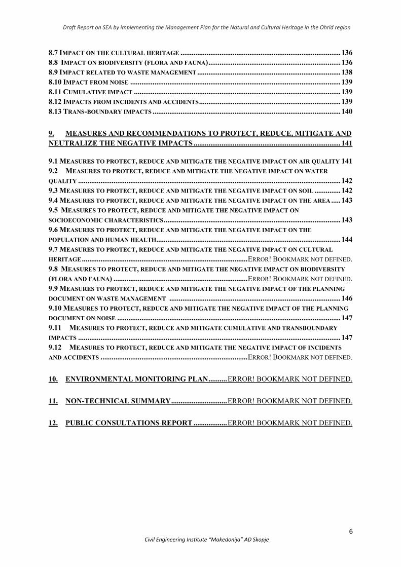
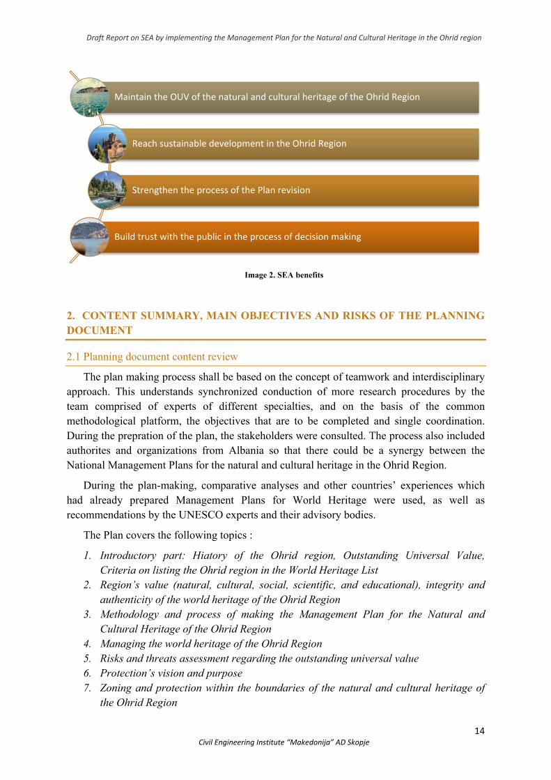
leads to a better environment protection and management (with emphasis given to the natural and cultural heritage) and promotes sustainable development in the Ohrid Region. Furthermore it stimulates the consulting processes with the public and stakeholders. Moreover, it strengthens the processes of making policies, preparing and adopting the Plan, and providing a lot of current and long-term benefits for the decision makers as the local self-government, the competent authorities, public institutions etc. The procedural benefits from the SEA include efficient planning processes and improved management of the Ohrid Region (Image 2). Therefore, this SEA Report can help the decision makers:
Draft Report on SEA by implementing the Management Plan for the Natural and Cultural Heritage in the Ohrid region
14 Civil Engineering Institute “Makedonija” AD Skopje
Image 2. SEA benefits
2. CONTENT SUMMARY, MAIN OBJECTIVES AND RISKS OF THE PLANNING DOCUMENT
2.1 Planning document content review
The plan making process shall be based on the concept of teamwork and interdisciplinary approach. This understands synchronized conduction of more research procedures by the team comprised of experts of different specialties, and on the basis of the common methodological platform, the objectives that are to be completed and single coordination. During the prepration of the plan, the stakeholders were consulted. The process also included authorites and organizations from Albania so that there could be a synergy between the National Management Plans for the natural and cultural heritage in the Ohrid Region.
During the plan-making, comparative analyses and other countries’ experiences which had already prepared Management Plans for World Heritage were used, as well as recommendations by the UNESCO experts and their advisory bodies.
The Plan covers the following topics :
1. Introductory part: Hiatory of the Ohrid region, Outstanding Universal Value, Criteria on listing the Ohrid region in the World Heritage List
2. Region’s value (natural, cultural, social, scientific, and educational), integrity and authenticity of the world heritage of the Ohrid Region
3. Methodology and process of making the Management Plan for the Natural and Cultural Heritage of the Ohrid Region
4. Managing the world heritage of the Ohrid Region 5. Risks and threats assessment regarding the outstanding universal value 6. Protection’s vision and purpose 7. Zoning and protection within the boundaries of the natural and cultural heritage of
the Ohrid Region
Maintain the OUV of the natural and cultural heritage of the Ohrid Region
Reach sustainable development in the Ohrid Region
Strengthen the process of the Plan revision
Build trust with the public in the process of decision making
Draft Report on SEA by implementing the Management Plan for the Natural and Cultural Heritage in the Ohrid region
15 Civil Engineering Institute “Makedonija” AD Skopje
8. Action plan 9. Monitoring plan 10. Visit Management Plan 11. Education programme 12. Appendices Review of the main topics explained is given as follows:
2.1.2 Criteria for listing the Ohrid Region in the World Heritage List
The natural and cultural heritage of the Ohrid region is a mixed world heritage which has been listed due to its natural values, back in 1979 (in accordance with criterion (iii), which is equal to the later reviewed criterion (vii). In 1980 the basis for the criterion was expanded so as to include the criteria for national values (i), (iii) and (iv).
2.1.3 Outstanding Universal Value
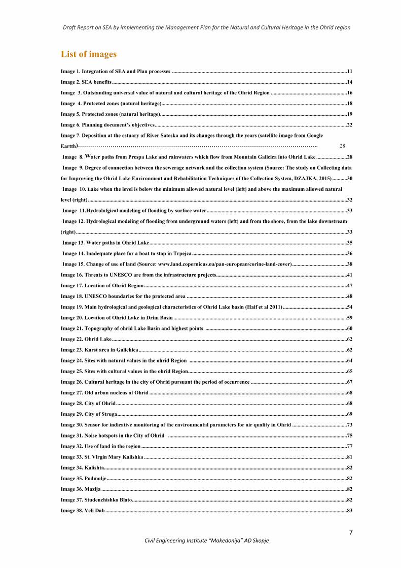
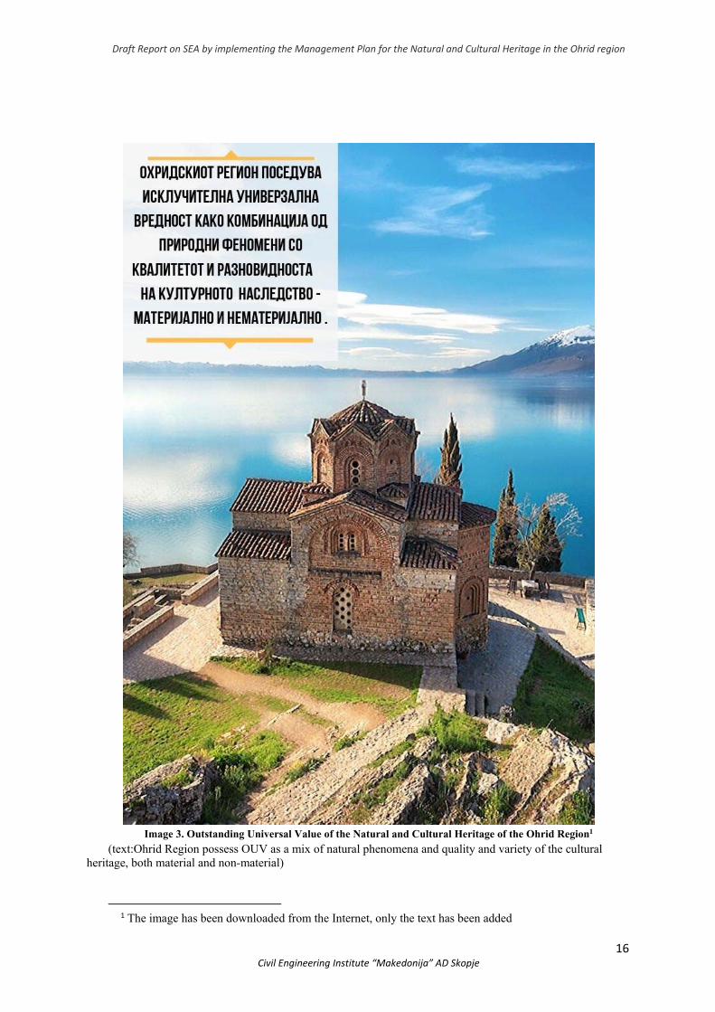
The „Outstanding Universal Value” (Image 3) of the UNESCO World Heritage relies on the following three pillars:
1. The area/site/monument shall meet at least one of the criteria set by the Operational Guide for Implementing the Convention on World Heritage
2. The area/site/monument shall meet the authenticity and integrity conditions 3. The area/site/monument shall meet the world heritage management and protection
conditions
2.1.4 Values
The Ohrid Lake is one of the oldest lakes in Europe and is surrounded by ancient roads and settlements which have been listed among the oldest in Europe. The natural and cultural history of this special place have intertwined through time, creating outstanding heritage which has to be maintained as such for the future generations. Apart from natural and cultural values, the region also possess scientific and educational as well as social values. What this region was prasied for and strives for is improved integrity and authenticity.
Draft Report on SEA by implementing the Management Plan for the Natural and Cultural Heritage in the Ohrid region
16 Civil Engineering Institute “Makedonija” AD Skopje
Image 3. Outstanding Universal Value of the Natural and Cultural Heritage of the Ohrid Region1
(text:Ohrid Region possess OUV as a mix of natural phenomena and quality and variety of the cultural heritage, both material and non-material)
1 The image has been downloaded from the Internet, only the text has been added
Draft Report on SEA by implementing the Management Plan for the Natural and Cultural Heritage in the Ohrid region
17 Civil Engineering Institute “Makedonija” AD Skopje
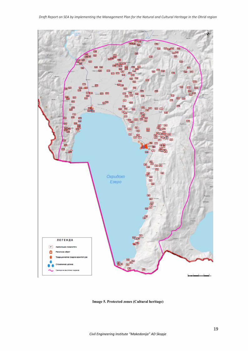
2.1.5 Zones and protective measures within the boundaries of the natural and cultural heritage of the Ohrid Region
The plan shall direct the future spatial development of the Ohrid Region in order to preserve the OUV. In doing so, zoning shall be done with defined protective measures for the natural and cultural heritage. By applying the system of values and establishing relations between the environmental, social and economic balance, zoning criteria have been defined for both the natural and cultural heritage.
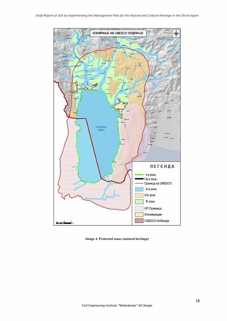
The natural heritage zones, which have had protective measures established, are provided by the morphological and topographic terrain features analysis, the height growth, the use of land in accordance with Corine Land Cоver, the protected areas and spatial presence thereof, as well as the shorezone functionalty index –SFI. The protective measures contain zones (Image 4) and a standard of allowed interventions i.e. activities which could be undertaken for the protected natural goods and displayed as protective measures in their vicinity:
● Zone 1 ● Zone 2 ● Zone 3 And the adequate subzones.
The plan provides adequate protective measures for each of the planned zones for natural heritage preservation. They give detailed description of the forbidden activities which need to be regulatied with an adequate legal act.
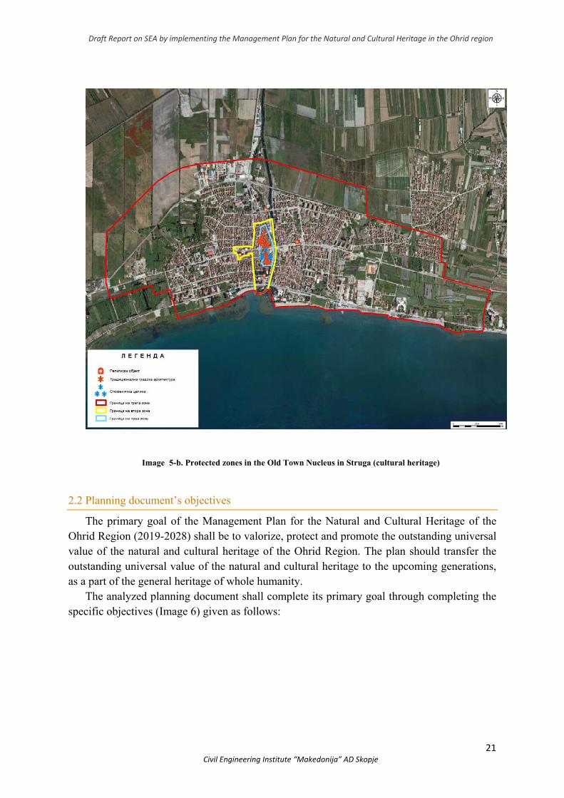
Having in mind the complexity and diversity of the cultural heritage, and in order to provide proper cultural heritage protection, sustainable development and controlled urbanization, several zones have been defined in the Ohrid Region (Image 5) with their own specific conditions and measures for preserving the following features: ● City urban centres, ● Religious heritage, ● Coastal and rural settlements, ● Archeological sites
The protective measures contain zones of protection (Image 5a and 5b) and a standard of allowed interventions i.e. activities which could be undertaken for the protected natural goods and displayed as protective measures in their vicinity:
● Zone 1 ● Zone 2 ● Zone 3 And the adequate subzones.
Draft Report on SEA by implementing the Management Plan for the Natural and Cultural Heritage in the Ohrid region
18 Civil Engineering Institute “Makedonija” AD Skopje
Image 4. Protected zones (natural heritage)
Draft Report on SEA by implementing the Management Plan for the Natural and Cultural Heritage in the Ohrid region
19 Civil Engineering Institute “Makedonija” AD Skopje
Image 5. Protected zones (Cultural heritage)

Draft Report on SEA by implementing the Management Plan for the Natural and Cultural Heritage in the Ohrid region
20 Civil Engineering Institute “Makedonija” AD Skopje
Image 5-a. Protected zones in the Old Town Nucleus in Ohrid (cultural heritage)
Draft Report on SEA by implementing the Management Plan for the Natural and Cultural Heritage in the Ohrid region
21 Civil Engineering Institute “Makedonija” AD Skopje
Image 5-b. Protected zones in the Old Town Nucleus in Struga (cultural heritage)
2.2 Planning document’s objectives
The primary goal of the Management Plan for the Natural and Cultural Heritage of the Ohrid Region (2019-2028) shall be to valorize, protect and promote the outstanding universal value of the natural and cultural heritage of the Ohrid Region. The plan should transfer the outstanding universal value of the natural and cultural heritage to the upcoming generations, as a part of the general heritage of whole humanity.
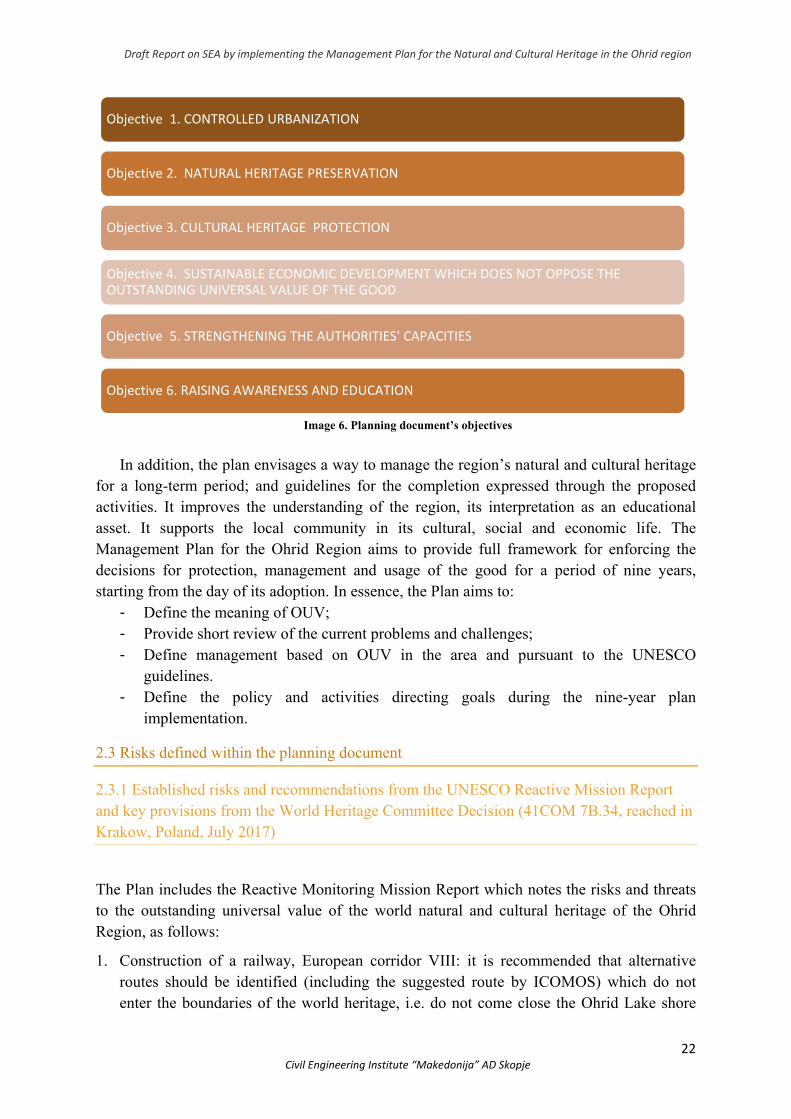
The analyzed planning document shall complete its primary goal through completing the specific objectives (Image 6) given as follows:
Draft Report on SEA by implementing the Management Plan for the Natural and Cultural Heritage in the Ohrid region
22 Civil Engineering Institute “Makedonija” AD Skopje
Image 6. Planning document’s objectives
In addition, the plan envisages a way to manage the region’s natural and cultural heritage
for a long-term period; and guidelines for the completion expressed through the proposed activities. It improves the understanding of the region, its interpretation as an educational asset. It supports the local community in its cultural, social and economic life. The Management Plan for the Ohrid Region aims to provide full framework for enforcing the decisions for protection, management and usage of the good for a period of nine years, starting from the day of its adoption. In essence, the Plan aims to:
- Define the meaning of OUV; - Provide short review of the current problems and challenges; - Define management based on OUV in the area and pursuant to the UNESCO
guidelines. - Define the policy and activities directing goals during the nine-year plan
implementation.
2.3 Risks defined within the planning document
2.3.1 Established risks and recommendations from the UNESCO Reactive Mission Report and key provisions from the World Heritage Committee Decision (41СОМ 7В.34, reached in Krakow, Poland, July 2017)
The Plan includes the Reactive Monitoring Mission Report which notes the risks and threats to the outstanding universal value of the world natural and cultural heritage of the Ohrid Region, as follows:
1. Construction of a railway, European corridor VIII: it is recommended that alternative routes should be identified (including the suggested route by ICOMOS) which do not enter the boundaries of the world heritage, i.e. do not come close the Ohrid Lake shore
Objective 1. CONTROLLED URBANIZATION
Objective 2. NATURAL HERITAGE PRESERVATION
Objective 3. CULTURAL HERITAGE PROTECTION
Objective 4. SUSTAINABLE ECONOMIC DEVELOPMENT WHICH DOES NOT OPPOSE THE OUTSTANDING UNIVERSAL VALUE OF THE GOOD
Objective 5. STRENGTHENING THE AUTHORITIES' CAPACITIES
Objective 6. RAISING AWARENESS AND EDUCATION
Draft Report on SEA by implementing the Management Plan for the Natural and Cultural Heritage in the Ohrid region
23 Civil Engineering Institute “Makedonija” AD Skopje
(the natural landscape of the Albanian-Macedonian border near Lin should be especially avoided) and the study on alternative routes should be delivered to the World Heritage Centre.
2. Construction of Motorway А2, European corridor VIII: sufficient number of crossings at Trebeniste-Struga section should be provided (the valley of Crn Drim and Sateska) for people and animals; coming across possible archeological sites through the construction should be taken into account.
3. Cumulative effect by the railway and the motorway, corridor VIII: the impact on the environment by any of the separate projects has been analysed through implementing the environmental impact assessment but the cumulative impact has not been treated yet. It should be analysed during the strategic impact assessment implementation from the Management Plan for the Natural and Cultural Heritage in the Ohrid Region.
4. Construction of state road А32: the impact from this route (its completion) is unacceptable, since it will inflict irreversible damage to the outstanding universal value of the world natural and cultural heritage.
5. Construction of a ski-centre Galicica3: In conjuction with the other developing projects and the changes in the settlements and shoreline so far, this project shall contribute to irreversible damage to the outstanding universal value of the world natural and cultural heritage.
6. Tourist developing projects/zones: tourist developing zones such as Krasta, Gradiste, Ljubaniste 1 and 2, are tourist objects of higher range of significance i.e. for congress tourism and are considered a threat without previously analysing the separate and cumulative impact of these projects. They should be analysed during the strategic impact assessment implementation from the Management Plan for the Natural and Cultural Heritage in the Ohrid Region.
Changes which occurred due to the urbanization are a threat to the outstanding universal value of the world heritage of the Ohrid Region, as claimed by the UNESCO-ICOMOS-IUCN Missions in 1998, ICOMOS Mission from December 2013 and the Reactive Monitoring Mission of the UNESCO World Heritage Centre as well as the advisory bodies (IUCN and ICOMOS) which was held on April 9-14th 207.
The mission held in 2017 established that the general condition of protecting the mixed world natural and cultural heritage of the Ohrid Region is threatened by many diverse factors which could in the end result in applying indents 179 and 180 of the Operational Instructions, which would mean that the authenticity and integrity of the heritage might become vulnerable.
In 2018, the Government adopted the Decision on Cancelling the Projects on sections (a) and (g) from the А3 road, the ski-centre Galicica as well as the projects on the tourist developing zones Krasta, Gradiste, Ljubaniste 1 and 2.
During the 43rd session of the World Heritage Committee in Baku (30th June– 10th July 2019), the Committee’s Decision (43СОМ 7В.36) recognizes the progress regarding the
2 This infrastructural project has been cancelled. 3 This infrastructural project has been cancelled.
Draft Report on SEA by implementing the Management Plan for the Natural and Cultural Heritage in the Ohrid region
24 Civil Engineering Institute “Makedonija” AD Skopje
implementation of part of the recommendations from the Reactive Mission which refer to cancelling the ideas for the ski centre, tourist developing zones and the road A3, as well as for the borrowings which the Government delegated to the authorities. However, the country needs to undertake other responsibilities which have been noted and are as follows:
● Recommendation regarding the alternatives that are to be analysed concerning the railway corridor VIII, which shall continue outside the boundaries of the protected area in North Macedonia and would add on to the proposed route passing outside the protected area in Albania;
● Impact assessment should be done regarding the cultural heritage from the route of A2 motorway, section Trebenishta-Struga;
● Moratorium of urban and shoreline transformation should be set until the adoption of proper planning documents and legal and controlling mechanisms that would guarantee the necessary protection;
● Inventory of the illegally constructed objects should be prepared; Environmental and Cultural Impact Assesment should be also implemented for the buildings so that it can be approached to their demolition thus their negative impact;
● Appropriate supervision should be done so as to prevent any further occurrence of illegally constructed objects;
● The Management Plan for the Natural and Cultural Heritage in the Ohrid Region should be completed and the Draft-Plan should be submitted to the World Heritage Centre and the Advisory bodies, before it is finalized and adopted;
● All other recommendations by the UNESCO Committee that were included in the Reactive Mission Report from 2017 should be implemented;
● Updated report should be submitted to the World Heritage Centre, not later than February 1st 2020 regarding the protection of welfare, which shall be reviewed at the 44th session in 2020 when the status of the welfare shall be finally determined i.e. weather the region would be listed within the List of World Heritage in danger.
2.3.2 Risks in accordance with the IUCN (International Union for Conservation of Nature) and GIWA (Global International Water Assessment) classification
The risk assessment (Image 6) has been done in accordance with the guidelines published by IUCN and GIWA. The IUCN recommends the classification which refers to the threats to the endangered flora and fauna, whereas the risks identified by GIWA apply the eco-system approach.
Risks present in Ohrid Lake Basin include:
● impact to the water quality in Ohrid Lake Basin,
● diffuse pollution, erosion and changes in the hydrology of agriculture and unsustainable forestry,
Draft Report on SEA by implementing the Management Plan for the Natural and Cultural Heritage in the Ohrid region
25 Civil Engineering Institute “Makedonija” AD Skopje
● pressure over the protected areas from unsustainable tourism,
● inclusion of allochtones,
● change or loss of habitats,
● unsustainable fishing and
● climate changes.
The effect of the impact/risks on the lake include damaged quality, changes in hydrology, loss of habitat and biological diversity etc. These effects can reflect to the economic and social aspects as well. It is important to underscore that these risks and effects are present in both sides of the lake (Albania and North Macedonia).
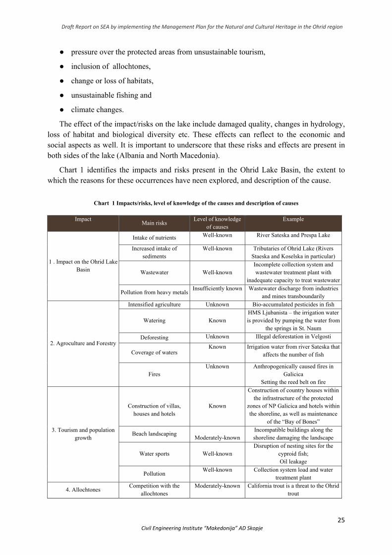
Chart 1 identifies the impacts and risks present in the Ohrid Lake Basin, the extent to which the reasons for these occurrences have neen explored, and description of the cause.
Chart 1 Impacts/risks, level of knowledge of the causes and description of causes
Impact
Main risks Level of knowledge
of causes Example
1 . Impact on the Ohrid LakeBasin
Intake of nutrients Well-known River Sateska and Prespa Lake
Increased intake of sediments
Well-known Tributaries of Ohrid Lake (Rivers Staeska and Koselska in particular)
Wastewater
Well-known Incomplete collection system and wastewater treatment plant with
inadequate capacity to treat wastewater
Pollution from heavy metalsInsufficiently known Wastewater discharge from industries
and mines transboundarily
2. Agroculture and Forestry
Intensified agriculture Unknown Bio-accumulated pesticides in fish
Watering
Known HMS Ljubanista – the irrigation water is provided by pumping the water from
the springs in St. Naum
Deforesting Unknown Illegal deforestation in Velgosti
Coverage of waters Known Irrigation water from river Sateska that
affects the number of fish
Fires Unknown Anthropogenically caused fires in
Galicica Setting the reed belt on fire
3. Tourism and population growth
Construction of villas,
houses and hotels
Known
Construction of country houses within the infrastructure of the protected
zones of NP Galicica and hotels within the shoreline, as well as maintenance
of the “Bay of Bones”
Beach landscaping
Moderately-known Incompatible buildings along the shoreline damaging the landscape
Water sports
Well-known Disruption of nesting sites for the
cyproid fish; Oil leakage
Pollution Well-known Collection system load and water
treatment plant
4. Allochtones Competition with the
allochtones Moderately-known California trout is a threat to the Ohrid
trout
Draft Report on SEA by implementing the Management Plan for the Natural and Cultural Heritage in the Ohrid region
26 Civil Engineering Institute “Makedonija” AD Skopje
Changes in population Insufficiently known Elodea canadensis in macrpphytes
communities
5. Changes and loss of habitats
Shoreline transofrmation
Well-known Fragmentation of Studenchisko Blato;
urbanization in the shoreline zone Fragmentation of the shoreline macrophyte
vegetation
Moderatey-known
Makrophytes line near Peshtani and
Trpejca
Changes and blocking up springs
Known
Usurpation of the St. Naum springs (construction of catering facilities) as well as blocking up the springs water
for irrigation
Capture of springs Well-known Capture of the spring Bej Bunar
Eutrophication
Insufficiently knownChange of microbiofilm and algae
communities especially in rocky shores
6. Unsustainable fishing
Excessive fishing Well-known Illegal fishing of Ohrid trout
Releasing allochtones and invasive types of fish
Insufficiently known Detected allochtones who appear to be a direct threat to the autochtone types
of fish
7. Global changes Raising of temperatures
Insufficiently known Increased eutriphication accompanied by anoxia in various parts of the lake which contributes to fish pestilence
Draft Report on SEA by implementing the Management Plan for the Natural and Cultural Heritage in the Ohrid region
27 Civil Engineering Institute “Makedonija” AD Skopje
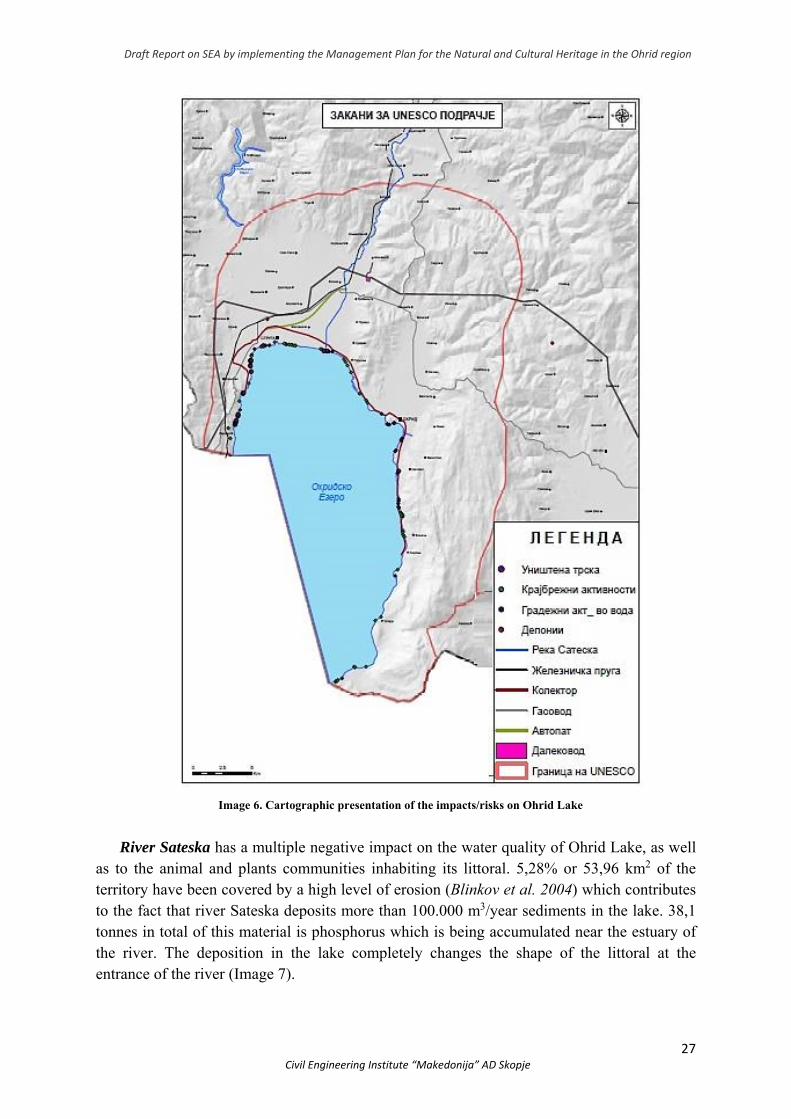
Image 6. Cartographic presentation of the impacts/risks on Ohrid Lake
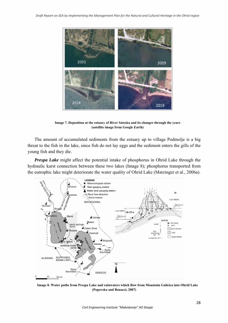
River Sateska has a multiple negative impact on the water quality of Ohrid Lake, as well as to the animal and plants communities inhabiting its littoral. 5,28% or 53,96 km2 of the territory have been covered by a high level of erosion (Blinkov et al. 2004) which contributes to the fact that river Sateska deposits more than 100.000 m3/year sediments in the lake. 38,1 tonnes in total of this material is phosphorus which is being accumulated near the estuary of the river. The deposition in the lake completely changes the shape of the littoral at the entrance of the river (Image 7).
Draft Report on SEA by implementing the Management Plan for the Natural and Cultural Heritage in the Ohrid region
28 Civil Engineering Institute “Makedonija” AD Skopje
Image 7. Deposition at the estuary of River Sateska and its changes through the years (satellite image from Google Earth)
The amount of accumulated sediments from the estuary up to village Podmolje is a big threat to the fish in the lake, since fish do not lay eggs and the sediment enters the gills of the young fish and they die.
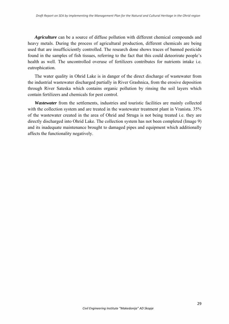
Prespa Lake might affect the potential intake of phosphorus in Ohrid Lake through the hydraulic karst connection between these two lakes (Image 8); phosphorus transported from the eutrophic lake might deteriorate the water quality of Ohrid Lake (Matzinger et al., 2006a).
Image 8. Water paths from Prespa Lake and rainwaters which flow from Mountain Galicica into Ohrid Lake (Popovska and Bonacci, 2007)
Draft Report on SEA by implementing the Management Plan for the Natural and Cultural Heritage in the Ohrid region
29 Civil Engineering Institute “Makedonija” AD Skopje
Agriculture can be a source of diffuse pollution with different chemical compounds and heavy metals. During the process of agricultural production, different chemicals are being used that are insufficiciently controlled. The research done shows traces of banned pesticide found in the samples of fish tissues, referring to the fact that this could deteorirate people’s health as well. The uncontrolled overuse of fertilizers contributes for nutrients intake i.e. eutrophication.
The water quality in Ohrid Lake is in danger of the direct discharge of wastewater from the industrial wastewater discharged partially in River Grashnica, from the erosive deposition through River Sateska which contains organic pollution by rinsing the soil layers which contain fertilizers and chemicals for pest control.
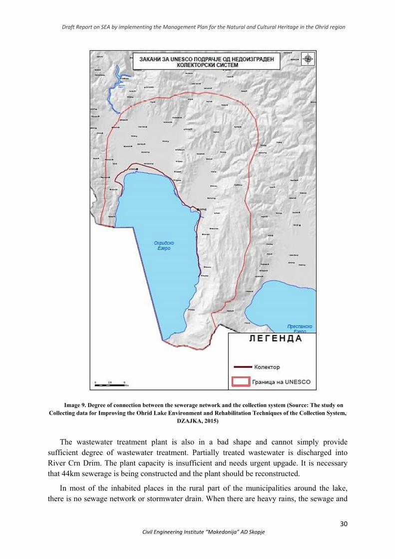
Wastewater from the settlements, industries and touristic facilities are mainly collected with the collection system and are treated in the wastewater treatment plant in Vranista. 35% of the wastewater created in the area of Ohrid and Struga is not being treated i.e. they are directly discharged into Ohrid Lake. The collection system has not been completed (Image 9) and its inadequate maintenance brought to damaged pipes and equipment which additionally affects the functionality negatively.
Draft Report on SEA by implementing the Management Plan for the Natural and Cultural Heritage in the Ohrid region
30 Civil Engineering Institute “Makedonija” AD Skopje
Image 9. Degree of connection between the sewerage network and the collection system (Source: The study on Collecting data for Improving the Ohrid Lake Environment and Rehabilitation Techniques of the Collection System,
DZAJKA, 2015)
The wastewater treatment plant is also in a bad shape and cannot simply provide sufficient degree of wastewater treatment. Partially treated wastewater is discharged into River Crn Drim. The plant capacity is insufficient and needs urgent upgade. It is necessary that 44km sewerage is being constructed and the plant should be reconstructed.
In most of the inhabited places in the rural part of the municipalities around the lake, there is no sewage network or stormwater drain. When there are heavy rains, the sewage and
Draft Report on SEA by implementing the Management Plan for the Natural and Cultural Heritage in the Ohrid region
31 Civil Engineering Institute “Makedonija” AD Skopje
stormwater mix and due to the insufficient capacity of the sewerage, there is wastewater owerflow from the manholes which floods parts of the urban areas. When this occurs, the collection system for the lake protection is overloaded due to which the wastewater is discharged into the lake. The overflow near Podmolje encourages the reed growth but it also pollutes the lake and contributes for unpleasant smell.
The waste collected from legal entities and households in Ohrid by the Public Enterprise “Ohridski Komunalen” is being removed to a non-standard municipal landfill Bukovo. It has been functioning since 1972; is is spread on an area of 60,000 m2 and is located 25km from the centre of Ohrid. With the national waste management plan (2009-2015), the landfill has been said to be extremely risky for the environment and it has to be closed by 2020. River Koselska might transport the pollution into Ohrid lake that would potentially be transferred from Bukovo landfill, which obviously does not meet the standards.
The unsustainable fishing in the lake reduces the number of fish, and many different types are affected, such as the endemic Ohrid trout (Salmo letnica).
The industrial capacities in the municipalities of Ohrid and Struga do not create such a large quantity of industrial wastewater. Generally, wastewater from these capacities is discharged into septic tanks. This is why industrial wastewater does not significantly pressure the water quality of Ohrid Lake.
The annual hydrological balance can be reached by regulating the flow of River Crn Drim and the redirection of River Sateska. Ohrid Lake flow is regulated in accordance with the agreed level of the lake – the natural minimum of 693 m.a.s.l. and a maximum of 694 m.a.s.l.
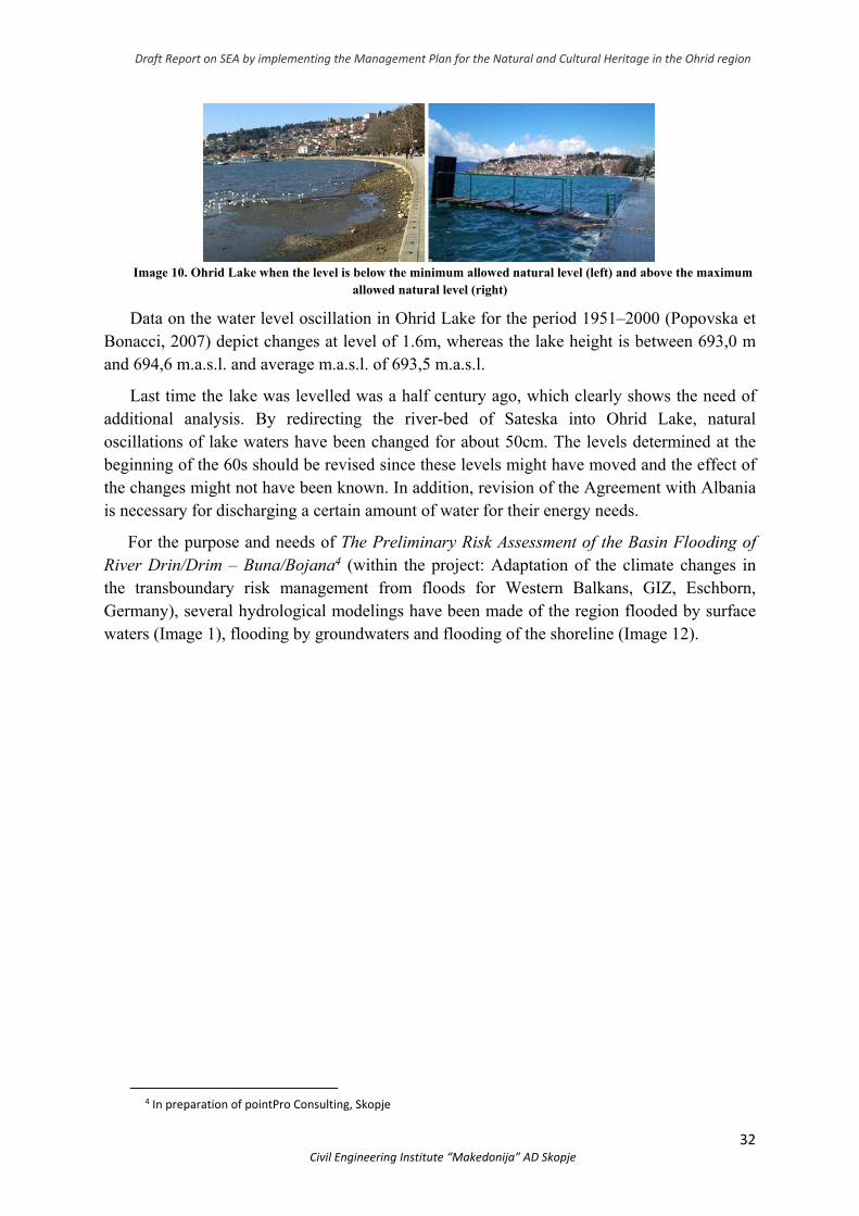
Although Ohrid Lake has been proclaimed for a world natural heritage protected by UNESCO, it has been used as an accumulator for production of electricity by AD ELEM for decades, based on the acquired permit from the water supply management.
The company for production and distribution of electricity AD ELEM is responsible for regulating the lake’s flow in North Macedonia. This regulation is done by discharging the water from the lake into River Crn Drim which is still being done manually with wooden beams. Along River Crn Drim there are two hydroelectric power plants at the territory of R. N. Macedonia, HEP Shpilje – Municipality of Debar and HEP Globochica near Municipality of Struga. In addition there are three more plants at the territory of Albania. Big oscillations in the water level which are usually a result of irregular management, impact the eco-system of Ohrid Lake negatively due to the water withdrawal and adequate impact on the biological diversity i.e. the lake’s overflow which happens when there is high level of water and rinsing of fertilizers and pesticide from the agricultural areas (Image 10).
Draft Report on SEA by implementing the Management Plan for the Natural and Cultural Heritage in the Ohrid region
32 Civil Engineering Institute “Makedonija” AD Skopje
Image 10. Ohrid Lake when the level is below the minimum allowed natural level (left) and above the maximum
allowed natural level (right)
Data on the water level oscillation in Ohrid Lake for the period 1951–2000 (Popovska et Bonacci, 2007) depict changes at level of 1.6m, whereas the lake height is between 693,0 m and 694,6 m.a.s.l. and average m.a.s.l. of 693,5 m.a.s.l.
Last time the lake was levelled was a half century ago, which clearly shows the need of additional analysis. By redirecting the river-bed of Sateska into Ohrid Lake, natural oscillations of lake waters have been changed for about 50cm. The levels determined at the beginning of the 60s should be revised since these levels might have moved and the effect of the changes might not have been known. In addition, revision of the Agreement with Albania is necessary for discharging a certain amount of water for their energy needs.
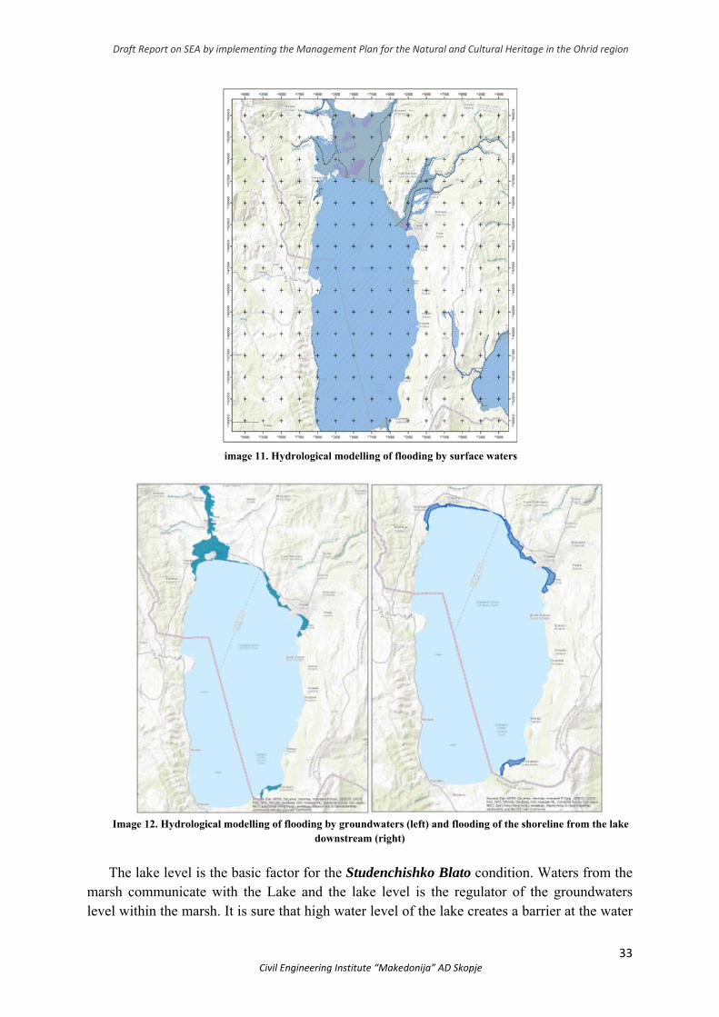
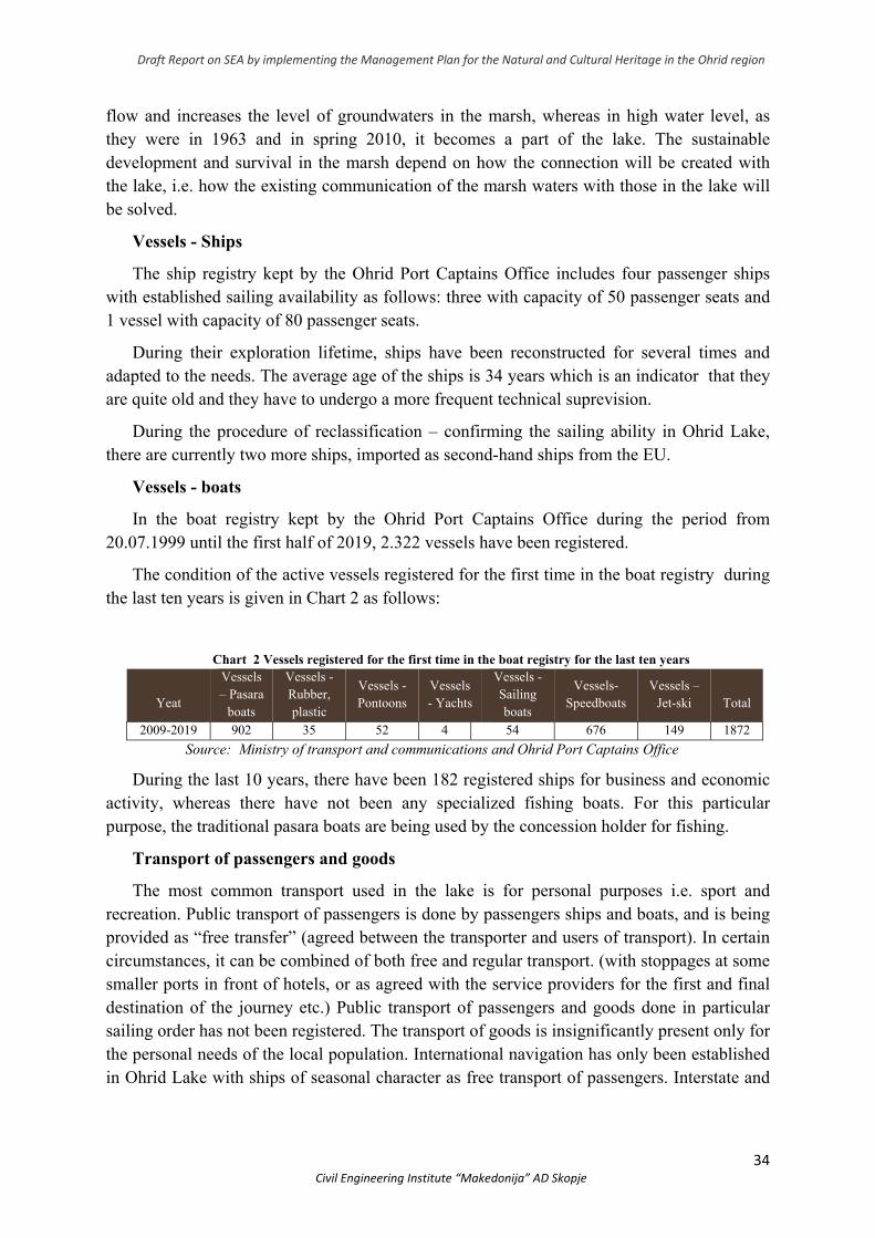
For the purpose and needs of The Preliminary Risk Assessment of the Basin Flooding of River Drin/Drim – Buna/Bojana4 (within the project: Adaptation of the climate changes in the transboundary risk management from floods for Western Balkans, GIZ, Eschborn, Germany), several hydrological modelings have been made of the region flooded by surface waters (Image 1), flooding by groundwaters and flooding of the shoreline (Image 12).
4 In preparation of pointPro Consulting, Skopje
Draft Report on SEA by implementing the Management Plan for the Natural and Cultural Heritage in the Ohrid region
33 Civil Engineering Institute “Makedonija” AD Skopje
image 11. Hydrological modelling of flooding by surface waters
Image 12. Hydrological modelling of flooding by groundwaters (left) and flooding of the shoreline from the lake
downstream (right)
The lake level is the basic factor for the Studenchishko Blato condition. Waters from the marsh communicate with the Lake and the lake level is the regulator of the groundwaters level within the marsh. It is sure that high water level of the lake creates a barrier at the water
Draft Report on SEA by implementing the Management Plan for the Natural and Cultural Heritage in the Ohrid region
34 Civil Engineering Institute “Makedonija” AD Skopje
flow and increases the level of groundwaters in the marsh, whereas in high water level, as they were in 1963 and in spring 2010, it becomes a part of the lake. The sustainable development and survival in the marsh depend on how the connection will be created with the lake, i.e. how the existing communication of the marsh waters with those in the lake will be solved.
Vessels - Ships
The ship registry kept by the Ohrid Port Captains Office includes four passenger ships with established sailing availability as follows: three with capacity of 50 passenger seats and 1 vessel with capacity of 80 passenger seats.
During their exploration lifetime, ships have been reconstructed for several times and adapted to the needs. The average age of the ships is 34 years which is an indicator that they are quite old and they have to undergo a more frequent technical suprevision.
During the procedure of reclassification – confirming the sailing ability in Ohrid Lake, there are currently two more ships, imported as second-hand ships from the EU.
Vessels - boats
In the boat registry kept by the Ohrid Port Captains Office during the period from 20.07.1999 until the first half of 2019, 2.322 vessels have been registered.
The condition of the active vessels registered for the first time in the boat registry during the last ten years is given in Chart 2 as follows:
Chart 2 Vessels registered for the first time in the boat registry for the last ten years
Yeat
Vessels – Pasara
boats
Vessels - Rubber, plastic
Vessels - Pontoons
Vessels - Yachts
Vessels - Sailing boats
Vessels- Speedboats
Vessels – Jet-ski
Total
2009-2019 902 35 52 4 54 676 149 1872
Source: Ministry of transport and communications and Ohrid Port Captains Office
During the last 10 years, there have been 182 registered ships for business and economic activity, whereas there have not been any specialized fishing boats. For this particular purpose, the traditional pasara boats are being used by the concession holder for fishing.
Transport of passengers and goods
The most common transport used in the lake is for personal purposes i.e. sport and recreation. Public transport of passengers is done by passengers ships and boats, and is being provided as “free transfer” (agreed between the transporter and users of transport). In certain circumstances, it can be combined of both free and regular transport. (with stoppages at some smaller ports in front of hotels, or as agreed with the service providers for the first and final destination of the journey etc.) Public transport of passengers and goods done in particular sailing order has not been registered. The transport of goods is insignificantly present only for the personal needs of the local population. International navigation has only been established in Ohrid Lake with ships of seasonal character as free transport of passengers. Interstate and
Draft Report on SEA by implementing the Management Plan for the Natural and Cultural Heritage in the Ohrid region
35 Civil Engineering Institute “Makedonija” AD Skopje
international public transport of passengers and goods has not been established for the two other natural lakes. i.e. Prespa Lake and Dojran Lake.
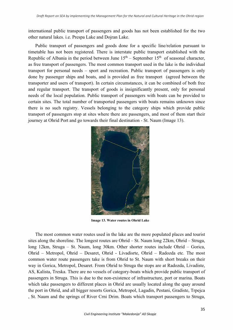
Public transport of passengers and goods done for a specific line/relation pursuant to timetable has not been registered. There is interstate public transport established with the Republic of Albania in the period between June 15th – September 15th of seasonal character, as free transport of passengers. The most common transport used in the lake is the individual transport for personal needs – sport and recreation. Public transport of passengers is only done by passenger ships and boats, and is provided as free transport (agreed between the transporter and users of transport). In certain circumstances, it can be combined of both free and regular transport. The transport of goods is insignificantly present, only for personal needs of the local population. Public transport of passengers with boats can be provided to certain sites. The total number of transported passengers with boats remains unknown since there is no such registry. Vessels belonging to the category ships which provide public transport of passengers stop at sites where there are passengers, and most of them start their journey at Ohrid Port and go towards their final destination - St. Naum (Image 13).
Image 13. Water routes in Ohrid Lake
The most common water routes used in the lake are the more populated places and tourist sites along the shoreline. The longest routes are Ohrid – St. Naum long 22km, Ohrid – Struga, long 12km, Struga – St. Naum, long 30km. Other shorter routes include Ohrid – Gorica, Ohrid – Metropol, Ohrid – Desaret, Ohrid - Livadisrte, Ohrid – Radozda etc. The most common water route passengers take is from Ohrid to St. Naum with short breaks on their way in Gorica, Metropol, Desaret. From Ohrid to Struga the stops are at Radozda, Livadiste, AS, Kalista, Treska. There are no vessels of category-boats which provide public transport of passengers in Struga. This is due to the non-existence of infrastructure, port or marina. Boats which take passengers to different places in Ohrid are usually located along the quay around the port in Ohrid, and all bigger resorts Gorica, Metropol, Lagadin, Pestani, Gradiste, Trpejca , St. Naum and the springs of River Crni Drim. Boats which transport passengers to Struga,
Draft Report on SEA by implementing the Management Plan for the Natural and Cultural Heritage in the Ohrid region
36 Civil Engineering Institute “Makedonija” AD Skopje
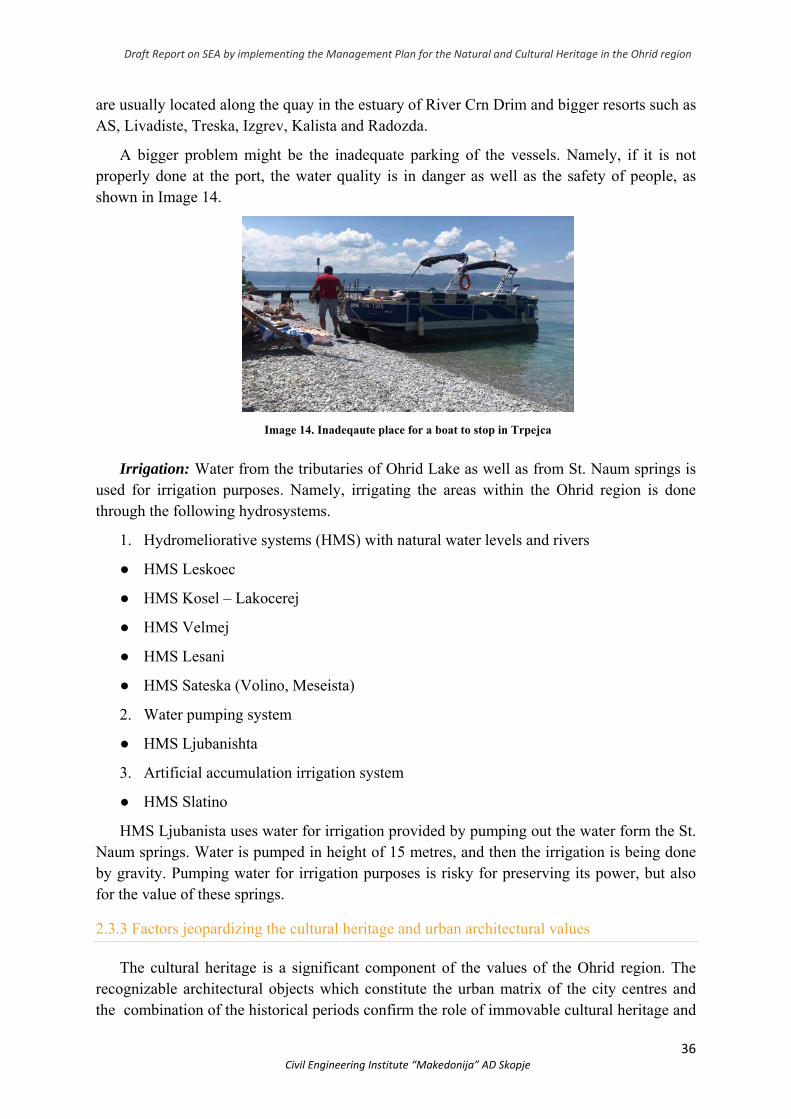
are usually located along the quay in the estuary of River Crn Drim and bigger resorts such as AS, Livadiste, Treska, Izgrev, Kalista and Radozda.
A bigger problem might be the inadequate parking of the vessels. Namely, if it is not properly done at the port, the water quality is in danger as well as the safety of people, as shown in Image 14.
Image 14. Inadeqaute place for a boat to stop in Trpejca
Irrigation: Water from the tributaries of Ohrid Lake as well as from St. Naum springs is used for irrigation purposes. Namely, irrigating the areas within the Ohrid region is done through the following hydrosystems.
1. Hydromeliorative systems (HMS) with natural water levels and rivers
● HMS Leskoec
● HMS Kosel – Lakocerej
● HMS Velmej
● HMS Lesani
● HMS Sateska (Volino, Meseista)
2. Water pumping system
● HMS Ljubanishta
3. Artificial accumulation irrigation system
● HMS Slatino
HMS Ljubanista uses water for irrigation provided by pumping out the water form the St. Naum springs. Water is pumped in height of 15 metres, and then the irrigation is being done by gravity. Pumping water for irrigation purposes is risky for preserving its power, but also for the value of these springs.
2.3.3 Factors jeopardizing the cultural heritage and urban architectural values
The cultural heritage is a significant component of the values of the Ohrid region. The recognizable architectural objects which constitute the urban matrix of the city centres and the combination of the historical periods confirm the role of immovable cultural heritage and
Draft Report on SEA by implementing the Management Plan for the Natural and Cultural Heritage in the Ohrid region
37 Civil Engineering Institute “Makedonija” AD Skopje
need of its adequate protection. However, besides the high number of objects to which necessary conservation and restoration interventions have been done, we still face huge number of factors that harm the cultural heritage.
● Incomplete professional space valorization and non-exsistance of studies for preservation of the constructed heritage for all populated places (the valorization and revalorization of the larger number of profane and religious objects at the territory of Municipalities of Ohrid, Struga and Debrca have been completed)
● Insufficient knowledge of the historical development of the region, i.e. the historical eras which affected the appearance and have caused numerous transformations of the area that negatively affect the possibility to recognize the opportunities and potential;
● Insufficiently developed general awareness for the values and potential of the space in general, as well as insufficient level of awareness for architectural and artistic values of the building and other cultural heritage;
● Constructing larger number of objects along the shoreline of Ohrid Lake which leads to continuous change of the existing structure of the settlements, to the landscape and shoreline in general;
● Concept mismatch for the development of separate economic branches with the spatial potential of the Ohrid region and the limitations set by the protection criteria (traffic and other infrastructure, big tourist resorts, factories, plants and stations, warehouses);
● Non-adjustment of the standard instruments for planning the promotion of the constructing heritage condition according to the prescribed protection criteria;
● Insufficient training and number of experts to perform the tasks around planning, designing and construction of all construction and other works in the Ohrid region regarding the knowledge and integration of heritage protection mechanisms;
● Non-existance of benefits or facilitation and assistance for the owners/users for sanation, restoration or conservation of their objects;
● Insufficient number of professional staff for the construction worls and craftwork.
● Insufficient number of professional staff for the works in research, conservation, restoration and protection of cultural heritage.
● Non-existance of constant assets and method of funding the preservation and improvement of the building and other cultural heritage condition.
2.3.4 Urbanization and illegally constructed objects
The urbanization of the Ohrid region has started during the XX century, and the urbanization of the newer parts of the citiy and tourist resorts along the shore has been especially intensive; the historical nuclei with smaller or bigger changes have remained within their constant and cultural landscape.
The excessive and uncontrolling utrbanization affects the following aspects negatively: the structure of old town nucleus of Ohrid and Struga with their old architecture and the
Draft Report on SEA by implementing the Management Plan for the Natural and Cultural Heritage in the Ohrid region
38 Civil Engineering Institute “Makedonija” AD Skopje
structure of the settlements along the shore and other places where additional cultural goods can be found.
Changes caused by the urbanization are a threat to jeopardize the outstanding universal value of the Ohrid Region, which has been also noted in the reports of the UNESCO-ICOMOS-IUCN Mission in 1998, ICOMOS Mission from December 2013 and the Reactive Monitoring Mission of the World Heritage Centre and the Advisory bodies (IUCN and ICOMOS) which took place on April 9th – 14th 2017.
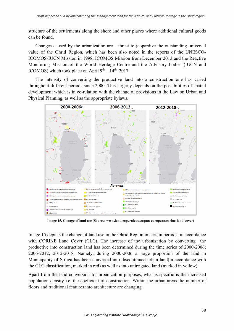
The intensity of converting the productive land into a construction one has varied throughout different periods since 2000. This larger;y depends on the possibilities of spatial development which is in co-relation with the change of provisions in the Law on Urban and Physical Planning, as well as the appropriate bylaws.
Image 15. Change of land use (Source: www.land.copernicus.eu/pan-european/corine-land-cover)
Image 15 depicts the change of land use in the Ohrid Region in certain periods, in accordance with CORINE Land Cover (CLC). The increase of the urbanization by converting the productive into construction land has been determined during the time series of 2000-2006; 2006-2012; 2012-2018. Namely, during 2000-2006 a large proportion of the land in Municipality of Struga has been converted into discontinued urban land(in accordance with the CLC classification, marked in red) as well as into unirrigated land (marked in yellow).
Apart from the land conversion for urbanization purposes, what is specific is the increased population density i.e. the coeficient of construction. Within the urban areas the number of floors and traditional features into architecture are changing.
Draft Report on SEA by implementing the Management Plan for the Natural and Cultural Heritage in the Ohrid region
39 Civil Engineering Institute “Makedonija” AD Skopje
The shoreline transformation for the period of 2012-208 has been analysed by keeping track of changes in the satellite images which refer to constructions along the shore and set lake platforms, as well as changes (decrease) in the reed areas. These changes are shown in Image 7 together with the rest of the alterations.
The recorded changes in the reed belt during 2011 are due to the growth of former smaller complexes into bigger ones and their expansion to the land, but also to the fact that the compelx reed did not use to be as dense as now. Therefore, the total number of reed complexes in 2011 (80) was lower than the registered one 25 years ago (105), whereas the total length of the reed belt has increased. Namely, since the measurements were done in 2011, the total area of the reed is 77,15 ha, which is for 2,8 ha larger than the one measured 25 years ago (apart from the uncontrolled reed damage by cutting, setting it on fire, uprooting, piling it up with land and debris).
Having in mind the current state of the reed area, in 2019 and after the inspection of Hydrobiological Institute (HBI), it could be seen that the people have destroyed the reed by cutting, firing, uprooting, or piling it up with land or debris in order to get “useful areas” for different purposes (arable land, landfill site, beaches, hotel resorts, carparks etc.). Some of the sites with natural values have been also under threat (Chaper 4 gives a detailed explanation).
The more serious problems with the increased urbanization occur with the expiry of validity of the General Urban Plan (GUP) for the shoreline area of the Municipality of Ohrid, which was annulled in 2005 with the Law on Spatial Planning (“Official Gazette of the Republic of Macedonia” no. 51/05). This stated that General Urban Plans are only adopted for the “City of Skopje and cities – seats of Municipalities” (Article 10). The transitional and final provisions for economic and other complexities which were adopted before this Law came into force, are implemented as Urban plans for uninhabited place (which shall comply with the provisions of this Law within one year of its entering into force).
Later, the adoption of the Law on Spatial and Urban Planning from 2009 (“Official Gazzete of the Republic of Macedonia” no. 91/2009), brought to increased urbanization enabled by the diverse urban documentation such as: State and local urban planning documentation, urban planning for tourist and developing zone, urban planning documentation for autocamp etc. This type of documentation and especially urban planning documentation for buildings of special interest which was introduced with the amendments of the legal decision of 2014 (The Law on Spatial and Urban Planning “Official Gazzette of the Republic of Macedonia no. 199/14), is a fragmentation of planning since plans could have been developed without any previously defined framework of spatial development at a higher level. Article 50 (Urban planning documentation was later annulled by the Constitutional Court at a session held on July 5th 2017 but the urban documentation such as : local urban planning documentation; state urban planning documentation; urban planning documentation for tourist and developing zone; urban planning documentation for autocamp and urban planning documentation for buildings of special interest are still in force within the existing Law on Spatial and Urban Planning (“Official Gazzette of the Republic of Macedonia” no. 199/14, 44/15, 193/15,31/16, 163/16 and 64/18).
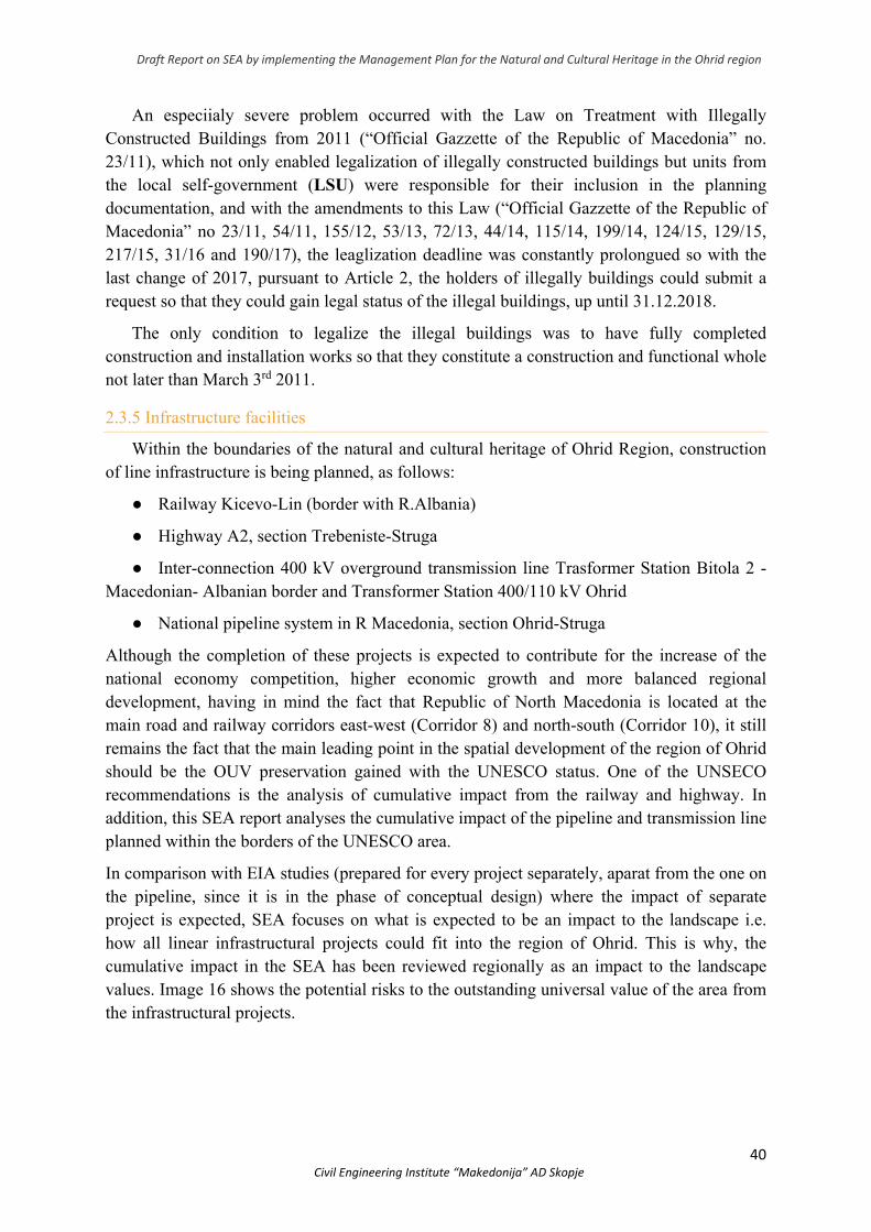
Draft Report on SEA by implementing the Management Plan for the Natural and Cultural Heritage in the Ohrid region
40 Civil Engineering Institute “Makedonija” AD Skopje
An especiialy severe problem occurred with the Law on Treatment with Illegally Constructed Buildings from 2011 (“Official Gazzette of the Republic of Macedonia” no. 23/11), which not only enabled legalization of illegally constructed buildings but units from the local self-government (LSU) were responsible for their inclusion in the planning documentation, and with the amendments to this Law (“Official Gazzette of the Republic of Macedonia” no 23/11, 54/11, 155/12, 53/13, 72/13, 44/14, 115/14, 199/14, 124/15, 129/15, 217/15, 31/16 and 190/17), the leaglization deadline was constantly prolongued so with the last change of 2017, pursuant to Article 2, the holders of illegally buildings could submit a request so that they could gain legal status of the illegal buildings, up until 31.12.2018.
The only condition to legalize the illegal buildings was to have fully completed construction and installation works so that they constitute a construction and functional whole not later than March 3rd 2011.
2.3.5 Infrastructure facilities
Within the boundaries of the natural and cultural heritage of Ohrid Region, construction of line infrastructure is being planned, as follows:
● Railway Kicevo-Lin (border with R.Albania)
● Highway А2, section Trebeniste-Struga
● Inter-connection 400 kV overground transmission line Trasformer Station Bitola 2 - Macedonian- Albanian border and Transformer Station 400/110 kV Ohrid
● National pipeline system in R Macedonia, section Ohrid-Struga
Although the completion of these projects is expected to contribute for the increase of the national economy competition, higher economic growth and more balanced regional development, having in mind the fact that Republic of North Macedonia is located at the main road and railway corridors east-west (Corridor 8) and north-south (Corridor 10), it still remains the fact that the main leading point in the spatial development of the region of Ohrid should be the OUV preservation gained with the UNESCO status. One of the UNSECO recommendations is the analysis of cumulative impact from the railway and highway. In addition, this SEA report analyses the cumulative impact of the pipeline and transmission line planned within the borders of the UNESCO area.
In comparison with EIA studies (prepared for every project separately, aparat from the one on the pipeline, since it is in the phase of conceptual design) where the impact of separate project is expected, SEA focuses on what is expected to be an impact to the landscape i.e. how all linear infrastructural projects could fit into the region of Ohrid. This is why, the cumulative impact in the SEA has been reviewed regionally as an impact to the landscape values. Image 16 shows the potential risks to the outstanding universal value of the area from the infrastructural projects.
Draft Report on SEA by implementing the Management Plan for the Natural and Cultural Heritage in the Ohrid region
41 Civil Engineering Institute “Makedonija” AD Skopje
Image 16. Threats to the UNESCO area from the infrastructural projects
The effects to the area could be defined as a result of the physical changes in the area arising from the new development of the Ohrid Region or from indirect effects such as a malpractice of management, bad construction practice which results in damaged quality of the area. These phusical changes can include introduction, change or removal of entities in the area such as objects or natural vegetation. The effects can be a result of new elements inserted in the area (railway, highway, transmission line pillars) which visually or physically disrupt and block the view through the area.
Generally, the visibility of the faciltities in the area refers to many different factors, such as: (i) distance of the viewers from the object; (ii) extent to which the relief shape, vegetation cover or structures such as the objects, can stop or hide the whole or part of the view; (iii)
Draft Report on SEA by implementing the Management Plan for the Natural and Cultural Heritage in the Ohrid region
42 Civil Engineering Institute “Makedonija” AD Skopje
extent to which the object is firm and (iv) extent to which the object differs in colour from its background. In addition, the point to which the object “breaks” the horizon, also affects the visibility.
Analyzing it cumulatively, the planned linear infrastructure in the Ohrid region is expected to cause disruptions in the area due to the construction of highway, 400 kV transmission line, railway and pipeline very closely and within the boundaries of an area considered to possess OUV of cultural and natural heritage. These disruptions are expected to cause “linear opening” through the habitats or disrupt the connection of the area due to the construction and maintenance of the infrastructure (for example, for the purpose of a transmission line, it is necessary that a corridor of about 30m is cleaned from vegetation) which is known to have environmental effects to the land and water eco-systems. These effects include loss of habitats and fragmentation, spreading invasive other species, danger of fires, animals disturbance and death. (For example, transmission lines cut the migratory paths of birds). They also include changes in the animals’ behaviour, pollution, changes in micro-climate and vegetation, loss of eco-system services, increased pressure of development, tourism, hunting, waste management etc. Although each of these projects is considered to be a key infrastructure for the economic sector, such as transport, energy and gas supply, it can also have negative social impact to the local population through exposure to new and market pressure, loss of land and migration as well as illegal distribution of expenses and benefits from the infrastructure projects.
Cummulative visual effects occur in case of visual interaction of two or more projects of similar type, visible at the horizon. In the case with the Ohrid region, the visual effects can be divided into two areas: 1. Strusko Pole and 2. Foot of Mt. Jablanica.
In continuation, Chart 3 shows the analyzed impact on the area, for each project separately and in each phase (both construction and functional). The impacts shown have been taken from the EIA study of each of the project, and regarding the pipeline project, since the EIA study has not been prepared yet, impacts that would be expected of such a construction were taken from another section in North Macedonia, for which there had been EIA prepared.
Chart 3 The impact of the infrsastructure projects in phases
PHASE
PROJECT
CONSTRUCTION FUNCTION
During the construction phase, due to the activities undertaken for clearing the route, movement of the workers and mechanization, there will be a short-term change in the visual effect of the landscape. The main impact during construction, related to the operational aspects of the proposed transmission line, is the result of the need in certain areas where it passes through a forest area to provide and
The proposed transmission line will be visually exposed and visible when its route passes through open terrain such as the Struga Field. This area is a large, open and flat landscape with numerous anthropogenic forms of land use and development, and as such possess low landscape quality, tolerant of change. Therefore, the proposed transmission line will be experienced as part of the wider landscape and will only cause indirect
Draft Report on SEA by implementing the Management Plan for the Natural and Cultural Heritage in the Ohrid region
43 Civil Engineering Institute “Makedonija” AD Skopje
TRANSMISSION LINE
(EIA study approved in 2013/14)
maintain a vegetation-cleared corridor.Impacts on agricultural land, orchards and vineyards, rural and urban habitats will be small and insignificant, although some parts of the mentioned habitats may be directly destroyed by the construction of pillars and the construction of new access roads.
visual effects in relation to its existing features. The section of the proposed transmission line passing through the lower parts of Mt. Jablanica, will be exposed to the settlements along the local road connecting Dolna Belica and Radolishta, in certain sectors covered by topography. Due to the scenic values, the landscape in this area can be classified with moderate sensitivity, but due to existing human influences and different infrastructure, it could be considered as tolerant of moderate change.
HIGHWAY
(EIA study approved in 2015 )
During the construction phase due to the activities undertaken for clearing the route, digging trenches, dumping, moving workers and mechanization there will be a short-term change in the visual effect of the landscape. The construction of the highway will require construction material that will require transportation and storage near the project area.
It is expected that the visual effect of the highway will be altered during the operational phase. The cleared land along the road will be continuously occupied by it, and during the entire functional life of the road on both sides there will be a free growth vegetation zone that will serve as a shock absorber. This will cause fragmentation of the natural habitats, i.e. their division into several parts. Large sections of the route are dominated by agricultural land, areas where crops are grown and various pesticides and fertilizers are applied. This is an area of low biodiversity where fragmentation already exists, not only because of the highway section but also because of these degraded natural habitats. Despite careful route planning, there will be a need to clear the route from vegetation, trees and the like, but because of its small width, interventions will be small, making visual changes unnecessary.
Draft Report on SEA by implementing the Management Plan for the Natural and Cultural Heritage in the Ohrid region
44 Civil Engineering Institute “Makedonija” AD Skopje
RAILROAD
(EIA study approved in 2010)
The landscape, within the construction zones, established along the alignment of the track will be visibly modified during construction. The number of construction zones, their size and locations will be specified in the technical documentation for construction. These zones, together with the locations where the building materials and track sections will be stored, will be visually noticeable and will cause changes in the aesthetics of the area. However, these changes will be of a short-term nature, with a duration equal to the time of construction. Because of this, as well as the fact that in most of the corridor, the route passes through a forest area, these changes will be negligible. Upon completion of the construction activities, and in accordance with the obligations embodied in the Law on Construction, micro-relief and vegetation in those areas will be subject to restoration.
At certain sites, the new line will cause limited visual changes to the existing area and landscape. Due to the narrow corridor, which covers the track, the length and number of tunnels, the proximity of the road connecting Kichevo, Ohrid and the Albanian border, and the distance from the settlements, the visual effect of the railroad is expected to be negligible. Landscapes with significant visual values, tourist and recreational zones, historical and architectural monuments, whose aesthetic values would be in conflict with it, are not found in the surrounding area. The Spatial Plan of the Republic of North Macedonia 2002-2020 does not record any declared or proposed protected areas of landscape diversity in the immediate vicinity of the Kichevo-Lin railway. Despite careful planning of the route, there will be a need to clear the route from vegetation, trees and some forestry units, but due to the small width of the line interventions will be small.
GAS PIPELINE
During the construction phase due to the activities undertaken for clearing the route, digging trenches, dumping, moving workers and mechanization there will be a short-term change in the visual effect of the landscape. Also, the facilities that will be built to maintain the pipeline at certain locations will have a long-term impact, but will not have a negative impact on visual aspects. The receptor will be local population.
Some of the impacts from the construction phase will continue into the exploitation phase. This primarily refers to clearing the route of vegetation, trees which will have visual effects. Due to the small width of the route the impacts are considered negligible.
The Strusko Pole (field) area has not been valued as scenically important. It is considered to be tolerant to changes and usual anthropogenic area (as it is stated in the EIA study on the transmission line). The magnitude of cumulative impact expected in this part by all infrastructural projects is of medium cumulative impact, due to wider space. Cummulative impact is expected from the road and railway infrastructure during the operational phase, for which the routes in space should align and measures for greening should be undertaken so as to decrease the visual impact on Strusko Pole.
Compared to Strusko Pole, the area in the foot of Mt.Jablanica has been valued in wider context and the cumulative impact of the linear infrastructure is considered to be big precisely due to the limitation of the space.
Draft Report on SEA by implementing the Management Plan for the Natural and Cultural Heritage in the Ohrid region
45 Civil Engineering Institute “Makedonija” AD Skopje
In the area of the foot of Mt. Jablanica, there is the so called “bottleneck” of the infrastructure which needs a special alterantive solution which is still in the planning phase (pipeline) or for which there is still a possibility for reviewing alternative route (railway).
Cummulative impact during the phase of construction is expected from the pipeline and transmission line.
What has to be pointed out is that Highway A2, section Trebeniste – Struga shall connect to section Struga – Kjafasan in near future (that would actually find itself into a”bottleneck”). Since during the preparation of the SEA, there was still no project program for the highway section as well as completed design of the route, it cannot be taken into consideration during the analysis of the cumulative impact.
Therefore, the following is recommended:
Analysis of alternative routes of the railway
Indentifying routes on the highway Struga – Kjafasan which together with the railway shall have minimum cumulative impact on the outstanding universal value.
Indentifying the route of pipeline which together with the transmission line towards the borders with Albania shall have minimum cumulative impact on the outstanding universal value.
2.3.6 Newly built objects within the old town nucleus
The modern urbanization in the Ohrid Region covers the free area near the shore of the lake as well as the free green areas in the old twon nucleus of both Ohrid and Struga. Individual family houses are mostly built, which are mostly inadequate regarding the height and volume as well as their architectural shape. These buildings change the well-known silhouette of the cities and the urban matrices features are being put in danger. This shall lead to disruption of the original spatial organization within the traditional whole.
The cultural heritage vulnerability has been increased by the permanent loss of the original features of individual elements, especially with:
1. Replacement of the so called old Turkish shingles with some other materials of the roof covering;
2. Change of the layout of windows and doors in a manner that wooden carpentry is being changed with plastic or aluminium which drastically changes the architecture of the buildings; Using new construction materials for the traditional ground level made of stone leads to loss of the authenticity of the traditional layout of walss and the original ambient is being disrupted;
3. Usage of different nuances in the façade (instead of the distinctive white boy) by private owners as well as using all sorts of materials inadequate for the existing architecture without using any wooden horizontal or vertical covering elements;
4. Disrespecting the distinctive architectural shape with decorated walls where constructions mostly finish either with protruding wooden canopy or with profiled canopy which
Draft Report on SEA by implementing the Management Plan for the Natural and Cultural Heritage in the Ohrid region
46 Civil Engineering Institute “Makedonija” AD Skopje
enriches the architecture of the building to which the roof construction starts and the roof coverage;
5. Changing tiling at squares and streets, with new modern construction materials which do not fin into the original ambient;
6. Advertising banners and other elements of the urban equipment (including dust bins set in the old nucleus of the city) disrupt the view to the objects and the ambiental and aesthetical values of the goods;
Risk factors contributing to the decrease i.e. loss of values of cultural heritage are:
1. Demographic growth and migration of population towards urban centres which leads to social changes and disruption of historic centres where buildings gain commercial function and apartments are usually too crowded and unhealthy;
2. The more increased use of motor vehicles and its inclusion in parts where there had never been planned any usage of vehicles since they produce atmospheric pollution and destructive vibrations;
3. Construction of tall buildings suffocating the historic urban centres, changing the microclimate as well;
4. Changed type and range of commercial activities which affect the economic functions of the historic area;
5. Not maintaining the old buildings and not comprehending the cultural and functional value which increases the possibility of collapse and demolition;
6. Numerous transformation of the area which negatively affects the possibility of recognizing the values and potential;
7. Insufficiently developed awareness for values and potential of the space in general, and awareness for architectural and artistic values of the construction and other cultural heritage;
8. Construction of increased number of buildings along the shoreline of Ohrid Lake which leads to continuous change of the existing structure of the settlements and the landscape itself;
9. Non-adjustment of the concepts for developing separate economic branches with the current potential of the Ohrid Region and limitations set by the protection criteria (traffic and other infrastructure, big touristic resorts, production plants and factories, stations, warehouses etc.);
10. Non-adjustment of the standard instruments for planning the promotion of the construction heritage state pursuant to the prescribed protection criteria; Inssuficient traning and number of professionals to execute the works regarding planning,
desgning and constriction in the Ohrid Region in terms of knowledge and integration of mechanisms for heritage preservation, as well as insufficient number of professional staff to perform the traditional, craft work.
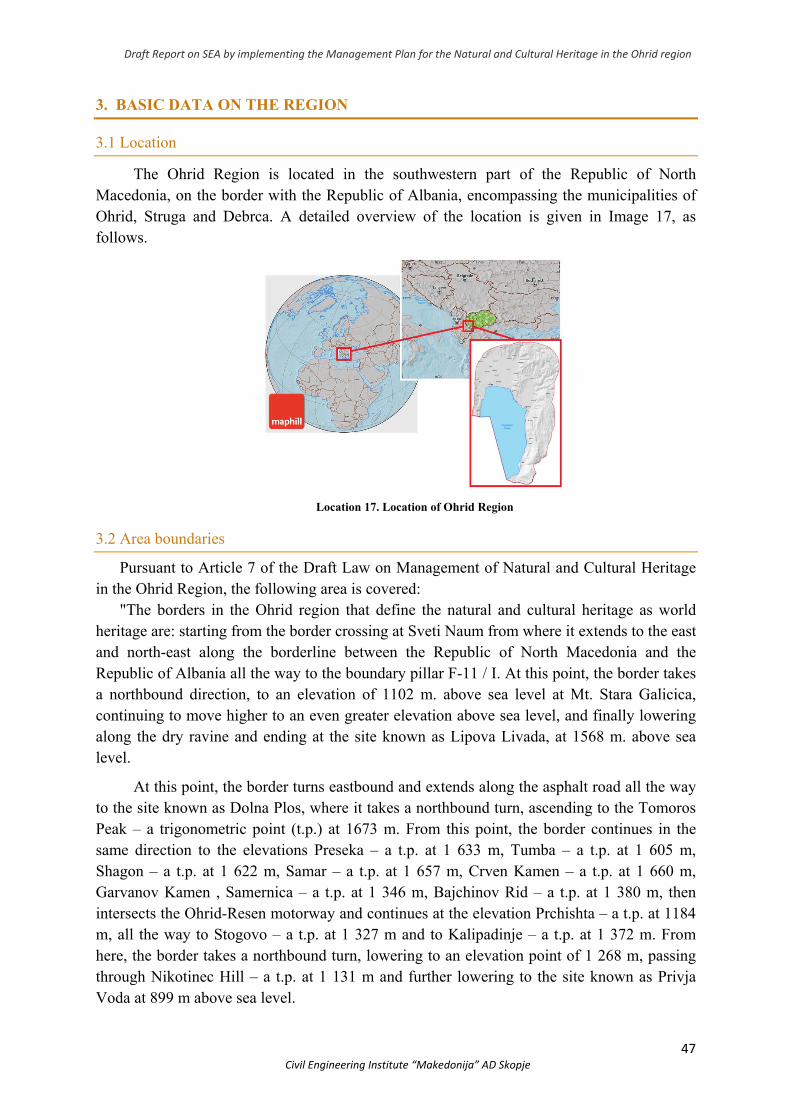
Draft Report on SEA by implementing the Management Plan for the Natural and Cultural Heritage in the Ohrid region
47 Civil Engineering Institute “Makedonija” AD Skopje
3. BASIC DATA ON THE REGION
3.1 Location
The Ohrid Region is located in the southwestern part of the Republic of North Macedonia, on the border with the Republic of Albania, encompassing the municipalities of Ohrid, Struga and Debrca. A detailed overview of the location is given in Image 17, as follows.
Location 17. Location of Ohrid Region
3.2 Area boundaries
Pursuant to Article 7 of the Draft Law on Management of Natural and Cultural Heritage in the Ohrid Region, the following area is covered:
"The borders in the Ohrid region that define the natural and cultural heritage as world heritage are: starting from the border crossing at Sveti Naum from where it extends to the east and north-east along the borderline between the Republic of North Macedonia and the Republic of Albania all the way to the boundary pillar F-11 / I. At this point, the border takes a northbound direction, to an elevation of 1102 m. above sea level at Mt. Stara Galicica, continuing to move higher to an even greater elevation above sea level, and finally lowering along the dry ravine and ending at the site known as Lipova Livada, at 1568 m. above sea level.
At this point, the border turns eastbound and extends along the asphalt road all the way to the site known as Dolna Plos, where it takes a northbound turn, ascending to the Tomoros Peak – a trigonometric point (t.p.) at 1673 m. From this point, the border continues in the same direction to the elevations Preseka – a t.p. at 1 633 m, Tumba – a t.p. at 1 605 m, Shagon – a t.p. at 1 622 m, Samar – a t.p. at 1 657 m, Crven Kamen – a t.p. at 1 660 m, Garvanov Kamen , Samernica – a t.p. at 1 346 m, Bajchinov Rid – a t.p. at 1 380 m, then intersects the Ohrid-Resen motorway and continues at the elevation Prchishta – a t.p. at 1184 m, all the way to Stogovo – a t.p. at 1 327 m and to Kalipadinje – a t.p. at 1 372 m. From here, the border takes a northbound turn, lowering to an elevation point of 1 268 m, passing through Nikotinec Hill – a t.p. at 1 131 m and further lowering to the site known as Privja Voda at 899 m above sea level.
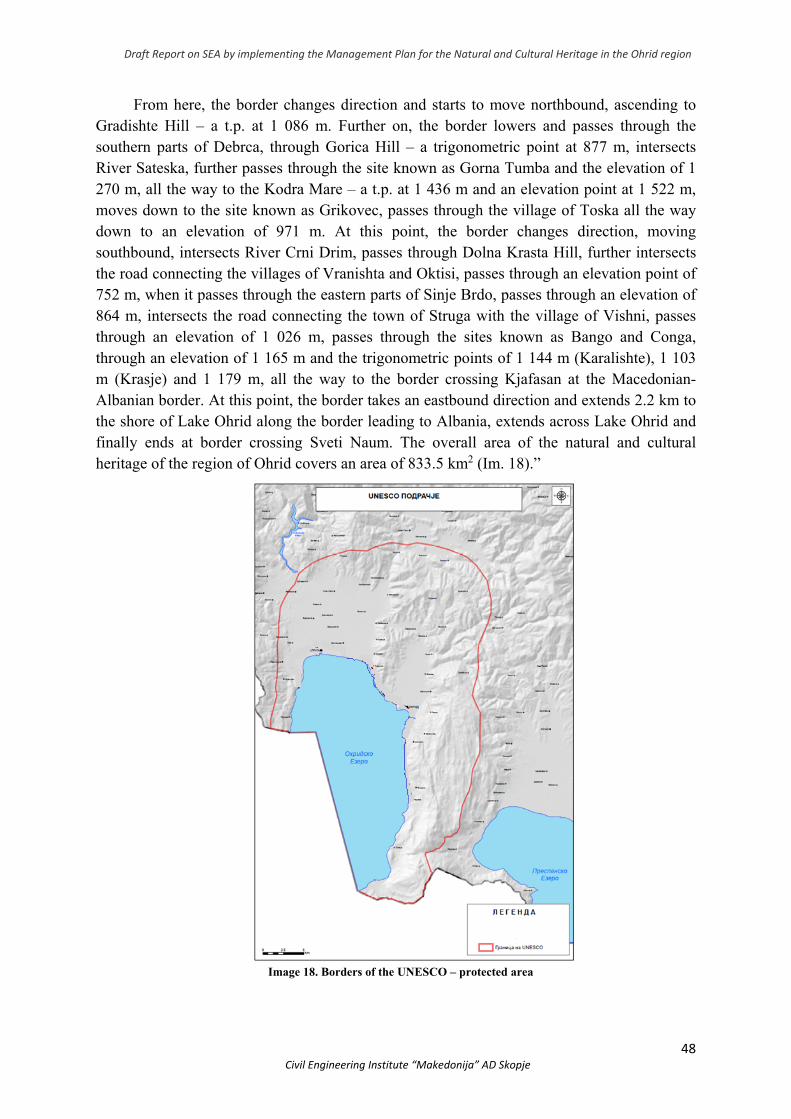
Draft Report on SEA by implementing the Management Plan for the Natural and Cultural Heritage in the Ohrid region
48 Civil Engineering Institute “Makedonija” AD Skopje
From here, the border changes direction and starts to move northbound, ascending to Gradishte Hill – a t.p. at 1 086 m. Further on, the border lowers and passes through the southern parts of Debrca, through Gorica Hill – a trigonometric point at 877 m, intersects River Sateska, further passes through the site known as Gorna Tumba and the elevation of 1 270 m, all the way to the Kodra Mare – a t.p. at 1 436 m and an elevation point at 1 522 m, moves down to the site known as Grikovec, passes through the village of Toska all the way down to an elevation of 971 m. At this point, the border changes direction, moving southbound, intersects River Crni Drim, passes through Dolna Krasta Hill, further intersects the road connecting the villages of Vranishta and Oktisi, passes through an elevation point of 752 m, when it passes through the eastern parts of Sinje Brdo, passes through an elevation of 864 m, intersects the road connecting the town of Struga with the village of Vishni, passes through an elevation of 1 026 m, passes through the sites known as Bango and Conga, through an elevation of 1 165 m and the trigonometric points of 1 144 m (Karalishte), 1 103 m (Krasje) and 1 179 m, all the way to the border crossing Kjafasan at the Macedonian-Albanian border. At this point, the border takes an eastbound direction and extends 2.2 km to the shore of Lake Ohrid along the border leading to Albania, extends across Lake Ohrid and finally ends at border crossing Sveti Naum. The overall area of the natural and cultural heritage of the region of Ohrid covers an area of 833.5 km2 (Im. 18).”
Image 18. Borders of the UNESCO – protected area
Draft Report on SEA by implementing the Management Plan for the Natural and Cultural Heritage in the Ohrid region
49 Civil Engineering Institute “Makedonija” AD Skopje
3.3 Socio-economic basis
The spatial coverage of the plan coincides with the territory determined by the administrative boundaries of the 3 municipalities: Ohrid, Struga and Debrca, according to the current administrative-territorial organization of the Republic of North Macedonia
3.3.1 Basic population characteristics
Population is one of the basic elements on which the prediction of the future organization is based. It is the most important factor in the future development of the country and society. Determining the concept of spatial organization, arrangement and use of the territory of the Region depends on development, structural changes and spatial distribution of the population
Total population According to the Population Census, Households, Dwellings and Agricultural Enterprises
in the Republic of North Macedonia in 2002 and according to the 2004 administrative-territorial division of Ohrid, there are 124,632 inhabitants living in Ohrid Region.
Chart 4 Total population, natural increase and migrations in municipalities, in accordance with the Sensus of 2002
Municipality Population Territorial distribution
Natural increase (promils)
Emmigrants Immigrants Migration balance
Ohrid 55.749 38,7 3,0 136 245 109
Struga 63.376 3,8 10,3 293 302 9
Debrca 5.507 44,9 -15,1 23 24 1
Natural increase Population increase dynamics in the analyzed period (2002) is, indexically, 113.4 ie.
0.4% on average per year. Natural population movements, analyzed through birth rate, mortality and natural increase indicators, tend to consistently reduce rates, resulting in a relatively slower process of population reproduction even in areas with high birth rates and natural growth rates. The highest increase is in the Municipality of Struga, compared to the other municipalities, as well as to the Republic (4.9 promiles); the rate in Ohrid is lower, while in Debrca the rate is negative
Migrations The mechanical changes in the population, expressed through migratory movements, in
particular have a negative impact in the case of small areas. They affect the total population, as well as the structural characteristics of the population, and imply short-term and long-term consequences
Population structure
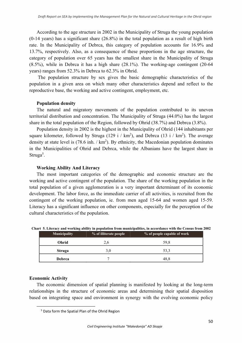
Draft Report on SEA by implementing the Management Plan for the Natural and Cultural Heritage in the Ohrid region
50 Civil Engineering Institute “Makedonija” AD Skopje
According to the age structure in 2002 in the Municipality of Struga the young population (0-14 years) has a significant share (26.8%) in the total population as a result of high birth rate. In the Municipality of Debrca, this category of population accounts for 16.9% and 13.7%, respectively. Also, as a consequence of these proportions in the age structure, the category of population over 65 years has the smallest share in the Municipality of Struga (8.5%), while in Debrca it has a high share (28.1%). The working-age contingent (20-64 years) ranges from 52.3% in Debrca to 62.3% in Ohrid.
The population structure by sex gives the basic demographic characteristics of the population in a given area on which many other characteristics depend and reflect to the reproductive base, the working and active contingent, employment, etc.
Population density The natural and migratory movements of the population contributed to its uneven
territorial distribution and concentration. The Municipality of Struga (44.0%) has the largest share in the total population of the Region, followed by Ohrid (38.7%) and Debrca (3.8%).
Population density in 2002 is the highest in the Municipality of Ohrid (144 inhabitants per square kilometer, followed by Struga (129 i / km2), and Debrca (13 i / km2). The average density at state level is (78.6 inh. / km2). By ethnicity, the Macedonian population dominates in the Municipalities of Ohrid and Debrca, while the Albanians have the largest share in Struga5.
Working Ability And Literacy The most important categories of the demographic and economic structure are the
working and active contingent of the population. The share of the working population in the total population of a given agglomeration is a very important determinant of its economic development. The labor force, as the immediate carrier of all activities, is recruited from the contingent of the working population, ie. from men aged 15-64 and women aged 15-59. Literacy has a significant influence on other components, especially for the perception of the cultural characteristics of the population.
Chart 5. Literacy and working ability in population from municipalities, in accordance with the Census from 2002
Municipality % of illiterate people % of people capable of work
Ohrid 2,6 59,8
Struga 3,0 53,3
Debrca 7 48,8
Economic Activity
The economic dimension of spatial planning is manifested by looking at the long-term relationships in the structure of economic areas and determining their spatial disposition based on integrating space and environment in synergy with the evolving economic policy
5 Data form the Spatial Plan of the Ohrid Region
Draft Report on SEA by implementing the Management Plan for the Natural and Cultural Heritage in the Ohrid region
51 Civil Engineering Institute “Makedonija” AD Skopje
tendencies, in order to preserve the ecological quality of the local community, the region and the country.
The structure of employees by activity shows that the largest number of employees is registered in industry (9 384 persons), which represents about 29.9% of the total number of employees in Ohrid - Prespa region, in the wholesale and retail trade and motor vehicle repair 3 964 employees (12.6%), in health and social work 2 606 or 8.3%, in public administration and defense, compulsory social protection 2 349 persons or 7.5% of the total number in the Region, 1 964 persons or 6.2% have occupation in education, 2 039 persons or 6.5% are engaged in construction, with agriculture - 1 760 persons or 5.6%, in transport, storage and communications are engaged 1 683 persons or 5.4%, in the hospitality/catering and tourism work around 1 550 people or 4.9% of persons performing an activity in the region. Only 114 persons or 0.4% of the total number of employees in the Region are engaged in fishing.
According to the spatial distribution of persons practicing in the Region, most (15 761) or
about 50% are registered in the Municipality of Ohrid, then 29.6% or about 9 270 persons in the Municipality of Struga, 15% and the rest are recorded in the Municipalities of Debrca (1 000 employees) and other municipalities in the Ohrid-Prespa region. In terms of the occupation they perform, most of the people employed (4 905) are service workers, shopkeepers and market sales, followed by 4 855 people who work in a non-industrial mode of production, followed by the same number of experts and scientists and technicians and related occupations (about 3 950 or 3 930 respectively), there are about 3 600 in machinery and plant operators and installers, 2 886 officials and about 2 020 members of the legislature, civil servants, senior civil servants, diplomats and directors.
3.3.2 Urban anad spatial planning
The planning documents that guide the spatial development of the area are: Spatial Plan of the Republic of North Macedonia i.e. Spatial Plan of the Ohrid-Prespa Region, General Urban Plans (GUP) of the cities of Ohrid and Struga, Detailed Urban Plans (DUP), urban plans for village, Urban Plans for non-populated areas (UPNPA), urban plans for areas and buildings of state importance, urban planning documentation for special interest buildings, state urban planning documentation (SUPD), local urban planner and planning documents (LUPD), urban planning documentation for tourism development zones (UPDTDZ), urban planning documentation for auto camps and infrastructure projects in the region of Ohrid.
The existing spatial plans that govern land use and land use within the boundaries of the World Natural and Cultural Heritage in the Ohrid region are as follows:
1. Spatial Plan of the Republic of North Macedonia (2004-2020); 2. Spatial Plan of the Ohrid-Prespa Region (2005-2020), 3. Spatial Landscape Plan of Galicica National Park (1988)
The Spatial Plan of the Municipality of Ohrid was adopted in 1988, but its validity has expired. The draft Spatial Plan for Galicica National Park (2010-2020) has not yet been finalized.
Draft Report on SEA by implementing the Management Plan for the Natural and Cultural Heritage in the Ohrid region
52 Civil Engineering Institute “Makedonija” AD Skopje
Urban plans Appropriate general, detailed urban plans and other types of urban planning
documentation have been adopted for the implementation of the spatial plans.
General Urban Plans (GUP)
General Urban Plan of Ohrid (1989 and 2006)
General Urban Plan of the Municipality of Struga (2007)
General Urban Plan of the coastal area of the Municipality of Ohrid (1989);
General Urban Plan of the Ohrid Municipality Coastal Area in the East Zone 1, Lagadin - Pestani Movement, Amendments (1997);
Plan for realization of tourist complex “Sveti Stefan - Ohrid ”(1983)
General Urban Plan for part of the coastal area, tourist site Gorica - Sveti Stefan - Metropol (2001)
Modification of part of the Urban Planning Area for the Ohrid Municipality (Zone North - Tourist site “Andon Dukov” (2001)
DUP for the coastal area “Kaneo - Studenchishta” (2001)
DUP for Grashnica coastal zone - an important part
Detailed Urban Plans (DUP)
DUP for the Lagadin Villa Complex (1987)
DUP for Trpeica settlement (1990)
Modifications and amendments of part of the detailed urban plan “Sveti Stefan-Ohrid” -Block1 (1999)
Amendments to the tourist complex “Sveti Stefan - Ohrid” (hotel and catering facility) (1999)
DUP for the Lagadin-Peshtani move (1999)
DUP for the coastal area “Kaneo-Studencista” (2001)
DUP for Grashnica Coastal Zone - Daljan (2001)
Urban documentation for settlement (UDS)
● UDS for Ljubanishta (1999) ● UDS for Podmolje (1999) ● UDS for Elshani ● UDS for Peshtani
Urban documentation outside the settlement (UDOS)
● UDOS for part of the tourist site Gorica – Sveti Stefan – Metropol, part of Block 2 (2008) ● UDOS for part of the tourist settlement Gorica – Istok (2008) ● UDOS for Lagadin – Peshtani part of UB 9 (2008)
Draft Report on SEA by implementing the Management Plan for the Natural and Cultural Heritage in the Ohrid region
53 Civil Engineering Institute “Makedonija” AD Skopje
Developed Urban Plans for the Village / General Acts for Places on the Territory of the Municipality of Debrca which are within the boundaries of the protected good:
- Botun - Leshani - Mesheishta - Trebenishta - Gorenci - Orovnik
General Urban Plans for The Cities of Ohrid and Struga
The General Urban Plan (GUP) for the city of Ohrid was valid from 2006 - 2016, while the GUP for the city of Struga was valid for the period 2007-2017. In 2013, the creation of a new GUP for the city of Struga was initiated, but this process was stopped by the National Institution for Protection of Cultural Monuments and Museum-Ohrid until the conservation bases for the planning area was developed. In 2015, an attempt was made to restart the adoption of a new GUP for the city of Struga, given that in the meantime several conservation bases for detailed urban plans have been prepared, i.e. a complete inventory of the protected buildings has been completed. In 2018 a new GUP for the city of Struga has started. Development of a new GUP for the city of Ohrid is planned to begin.
In the period between 2013 and 2019, Urban Plan for the villages: Velmej, Laktinje, Pesochan, Zleti, Klimeshtani, Izdeglavje, Volino, Slatino with Slatin Lake, Crvena Voda, Botun, G. Sredoreche, D. Sredoreche, Orovnik, Gorenci, Trebenishta and General acts for the villages of Grko Pole, Brezani, Arbinovo, Godivje, Mamororec, Turije, Sosani, Ozdoleni and Slatinski Chiflik are being prepared
The following General Acts have already been made: for the villages Orovnik,
Gorenci, Trebenishta, Mesheishta, Botun, Belchista, Leshani, Slivovo, Vrbjani, Dolno Sredoreche and Laktinje.
Planning and land use in the Ohrid region is ensured by the development, adoption and implementation of mutually harmonized spatial and urban plans.
According to the SSO (State Statistics Office), an overview of the illegally constructed buildings in the Region is presented in Chart 6
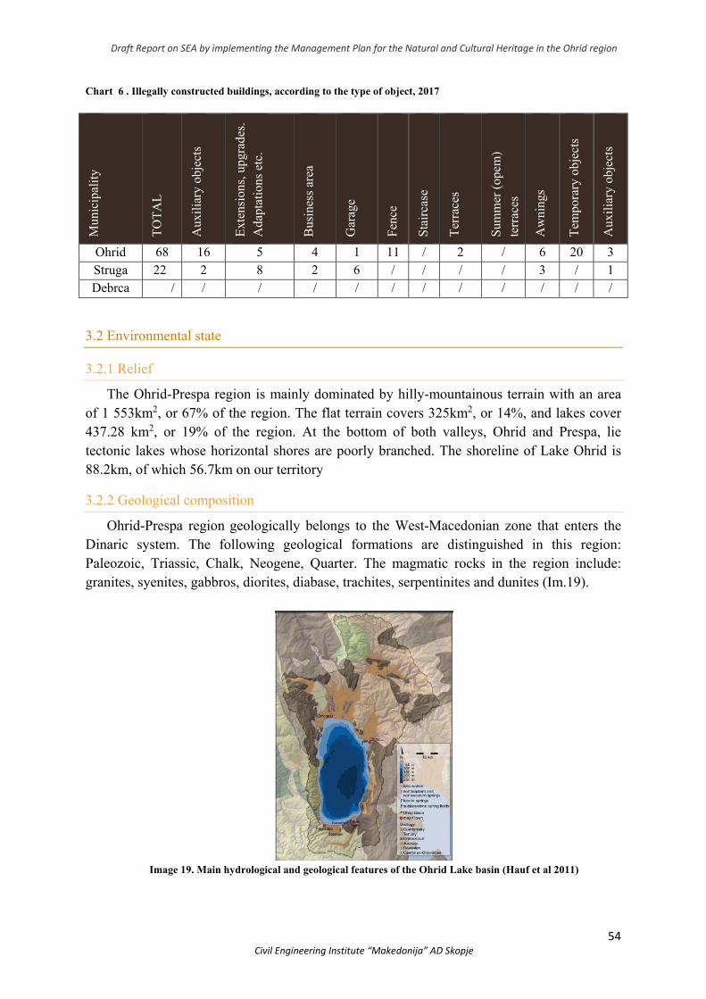
Draft Report on SEA by implementing the Management Plan for the Natural and Cultural Heritage in the Ohrid region
54 Civil Engineering Institute “Makedonija” AD Skopje
Chart 6 . Illegally constructed buildings, according to the type of object, 2017
Mun
icip
alit
y
TО
TA
L
Aux
ilia
ry o
bjec
ts
Ext
ensi
ons,
upg
rade
s.
Ada
ptat
ions
etc
.
Bus
ines
s ar
ea
Gar
age
Fen
ce
Sta
irca
se
Ter
race
s
Sum
mer
(op
em)
terr
aces
Aw
ning
s
Tem
pora
ry o
bjec
ts
Aux
ilia
ry o
bjec
ts
Ohrid 68 16 5 4 1 11 / 2 / 6 20 3 Struga 22 2 8 2 6 / / / / 3 / 1 Debrca / / / / / / / / / / / /
3.2 Environmental state
3.2.1 Relief
The Ohrid-Prespa region is mainly dominated by hilly-mountainous terrain with an area of 1 553km2, or 67% of the region. The flat terrain covers 325km2, or 14%, and lakes cover 437.28 km2, or 19% of the region. At the bottom of both valleys, Ohrid and Prespa, lie tectonic lakes whose horizontal shores are poorly branched. The shoreline of Lake Ohrid is 88.2km, of which 56.7km on our territory
3.2.2 Geological composition
Ohrid-Prespa region geologically belongs to the West-Macedonian zone that enters the Dinaric system. The following geological formations are distinguished in this region: Paleozoic, Triassic, Chalk, Neogene, Quarter. The magmatic rocks in the region include: granites, syenites, gabbros, diorites, diabase, trachites, serpentinites and dunites (Im.19).
Image 19. Main hydrological and geological features of the Ohrid Lake basin (Hauf et al 2011)
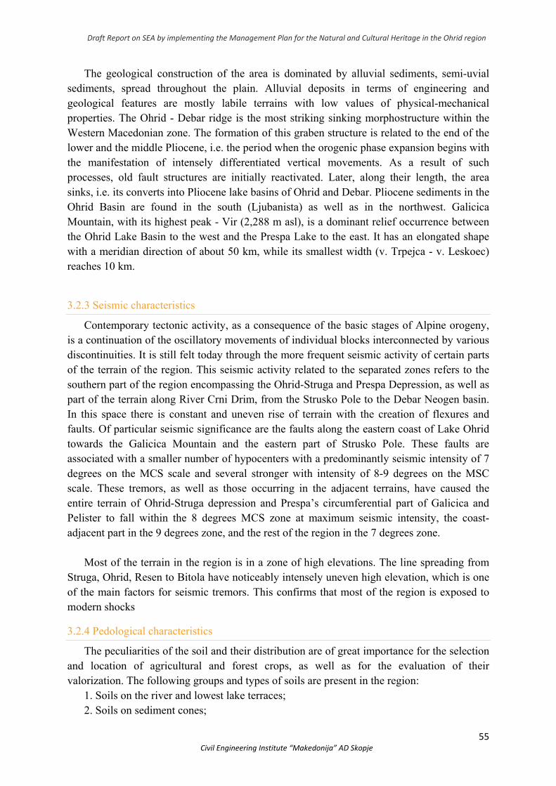
Draft Report on SEA by implementing the Management Plan for the Natural and Cultural Heritage in the Ohrid region
55 Civil Engineering Institute “Makedonija” AD Skopje
The geological construction of the area is dominated by alluvial sediments, semi-uvial sediments, spread throughout the plain. Alluvial deposits in terms of engineering and geological features are mostly labile terrains with low values of physical-mechanical properties. The Ohrid - Debar ridge is the most striking sinking morphostructure within the Western Macedonian zone. The formation of this graben structure is related to the end of the lower and the middle Pliocene, i.e. the period when the orogenic phase expansion begins with the manifestation of intensely differentiated vertical movements. As a result of such processes, old fault structures are initially reactivated. Later, along their length, the area sinks, i.e. its converts into Pliocene lake basins of Ohrid and Debar. Pliocene sediments in the Ohrid Basin are found in the south (Ljubanista) as well as in the northwest. Galicica Mountain, with its highest peak - Vir (2,288 m asl), is a dominant relief occurrence between the Ohrid Lake Basin to the west and the Prespa Lake to the east. It has an elongated shape with a meridian direction of about 50 km, while its smallest width (v. Trpejca - v. Leskoec) reaches 10 km.
3.2.3 Seismic characteristics
Contemporary tectonic activity, as a consequence of the basic stages of Alpine orogeny, is a continuation of the oscillatory movements of individual blocks interconnected by various discontinuities. It is still felt today through the more frequent seismic activity of certain parts of the terrain of the region. This seismic activity related to the separated zones refers to the southern part of the region encompassing the Ohrid-Struga and Prespa Depression, as well as part of the terrain along River Crni Drim, from the Strusko Pole to the Debar Neogen basin. In this space there is constant and uneven rise of terrain with the creation of flexures and faults. Of particular seismic significance are the faults along the eastern coast of Lake Ohrid towards the Galicica Mountain and the eastern part of Strusko Pole. These faults are associated with a smaller number of hypocenters with a predominantly seismic intensity of 7 degrees on the MCS scale and several stronger with intensity of 8-9 degrees on the MSC scale. These tremors, as well as those occurring in the adjacent terrains, have caused the entire terrain of Ohrid-Struga depression and Prespa’s circumferential part of Galicica and Pelister to fall within the 8 degrees MCS zone at maximum seismic intensity, the coast-adjacent part in the 9 degrees zone, and the rest of the region in the 7 degrees zone.
Most of the terrain in the region is in a zone of high elevations. The line spreading from
Struga, Ohrid, Resen to Bitola have noticeably intensely uneven high elevation, which is one of the main factors for seismic tremors. This confirms that most of the region is exposed to modern shocks
3.2.4 Pedological characteristics
The peculiarities of the soil and their distribution are of great importance for the selection and location of agricultural and forest crops, as well as for the evaluation of their valorization. The following groups and types of soils are present in the region:
1. Soils on the river and lowest lake terraces; 2. Soils on sediment cones;
Draft Report on SEA by implementing the Management Plan for the Natural and Cultural Heritage in the Ohrid region
56 Civil Engineering Institute “Makedonija” AD Skopje
3. Soils of the wavy tertiary and deluvial sedimentary terrains and lake terraces and 4. Soils on mountainous terrain on compact rocks.
3.2.5 Cimate characteristics
а) Air temperature Data used to describe the characteristics of the region refer to the period 1961-1990 for
the Ohrid and Struga measuring points. Most of this valley is under the water of Lake Ohrid, which is located in a deep and
closed valley, bounded on the east by the mountain Galicica (1 945m), and on the west by Jablanica (2 257m) and is located at an altitude of 695 meters. The basin of Lake Ohrid consists of 40 rivers, 23 of which are in Albanian and 17 in Macedonian territory. The Ohrid Valley lies at an altitude of 695 to 760 meters. It is about 110km from the Adriatic Sea and, through the western mountain pass, there are conditions for penetration of maritime air masses, but in this valley the impact of the lake is more pronounced as seen at higher air temperatures in winter and somewhat reduced in the summer months. The average annual temperature in Ohrid is 11.1°С, and in Struga 10.7°С, the average January temperature in Ohrid is 1.7°С and in Struga 0.9°С, the average February temperature in Ohrid is 2.7°С and in Struga 2.2°С, and the average December temperature in Ohrid is 3.3°С in Struga is 2.7°С. However, in the summer months the difference in the air temperature between Ohrid and Struga is quite small. In July Ohrid is only 0.1°С; and in August 0.3°С warmer than Struga. The impact of Lake Ohrid in the valley is manifested by the decrease of the annual temperature fluctuations. Lake Ohrid as a thermoregulator of the surrounding air shows an impact by lowering the air temperature in the warm part of the year, especially in the summer months.
а) Precipitation in the Ohrid Valley
Precipitation in the Ohrid valley is conditioned by the Mediterranean pluvimeter regime. Most of the annual rainfall falls in the cold part of the year, reaching its maximum in late autumn, and lower in the warm part of the year, with a minimum in the summer months. It is also significant that the rains in the Ohrid valley are mainly of rain and a very small amount of short-term snow. On average, the Ohrid valley has 19 days of snow cover per year. The development of vegetation is important for the distribution of average temperatures and rainfall per year, as well as during the vegetation period (01. IV to 30. IX)
Autumn is warmer than spring, and the average air temperature during the vegetation period is 16.8°C. The rainfall schedule is quite erratic. Namely, the highest amount of rainfall is in winter (224mm) and autumn (208mm), and the smallest in summer (96mm). During the vegetation period, 248mm of aqueous sediment falls, which represents 35% of the total amount of rainfall
b) Sunshine, Cloudiness and Humidity in the Ohrid Valley
The Ohrid valley is characterized by long-lasting solar radiation. The average annual solar radiation is 2 233 hours or an average of 6 hours per day with a maximum in July and a minimum in January.
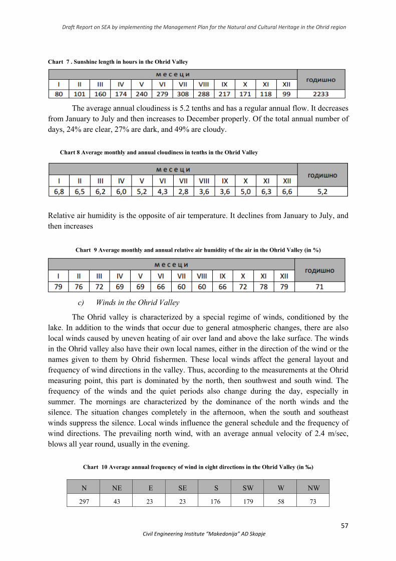
Draft Report on SEA by implementing the Management Plan for the Natural and Cultural Heritage in the Ohrid region
57 Civil Engineering Institute “Makedonija” AD Skopje
Chart 7 . Sunshine length in hours in the Ohrid Valley
The average annual cloudiness is 5.2 tenths and has a regular annual flow. It decreases from January to July and then increases to December properly. Of the total annual number of days, 24% are clear, 27% are dark, and 49% are cloudy.
Chart 8 Average monthly and annual cloudiness in tenths in the Ohrid Valley
Relative air humidity is the opposite of air temperature. It declines from January to July, and then increases
Chart 9 Average monthly and annual relative air humidity of the air in the Ohrid Valley (in %)
c) Winds in the Ohrid Valley
The Ohrid valley is characterized by a special regime of winds, conditioned by the lake. In addition to the winds that occur due to general atmospheric changes, there are also local winds caused by uneven heating of air over land and above the lake surface. The winds in the Ohrid valley also have their own local names, either in the direction of the wind or the names given to them by Ohrid fishermen. These local winds affect the general layout and frequency of wind directions in the valley. Thus, according to the measurements at the Ohrid measuring point, this part is dominated by the north, then southwest and south wind. The frequency of the winds and the quiet periods also change during the day, especially in summer. The mornings are characterized by the dominance of the north winds and the silence. The situation changes completely in the afternoon, when the south and southeast winds suppress the silence. Local winds influence the general schedule and the frequency of wind directions. The prevailing north wind, with an average annual velocity of 2.4 m/sec, blows all year round, usually in the evening.
Chart 10 Average annual frequency of wind in eight directions in the Ohrid Valley (in ‰)
N NE E SE S SW W NW
297 43 23 23 176 179 58 73
Draft Report on SEA by implementing the Management Plan for the Natural and Cultural Heritage in the Ohrid region
58 Civil Engineering Institute “Makedonija” AD Skopje
d) Evaporation, Fog and Dew in the Ohrid Valley
The evaporation from the free water surface is greater than the fall precipitation. The average annual evaporation rate is 836 l/m2 while the annual rainfall is 708.3 l/m2. Evaporation is highest in August at 137 l/m2 and lowest in January at 27 l/m2. Fog is a rare occurrence in the Ohrid valley. On average, there are 5 days of fog each year, two in January and one in November, December and February. The dew occurs throughout the year but is most frequent from April to June and from September to November. There are an average of 113 days of dew a year. According to J. Mavrodiev’s methodology for climate areas, the climate in the Ohrid valley belongs to the warm continental climate area up to about 800 m above sea level.
e) Climate changes Anticipated climate changes (expressed as changes in air temperature and
precipitation) are gradually evolving and the results are significant over the longer term. The floods have the biggest impact. Floods are a frequent occurrence in the Republic of North Macedonia, being a local manifestation of the consequences of global changes and causing significant damage.
According to the prepared regional scenarios for North Macedonia, this zone is dominated by continental climate. The analysis of these climate scenarios shows that the semi-annual temperature in this refugial zone in 50 years will rise by an average of 2.0°C, while in 100 years by an average of 4.0°C. Thereby the winter temperatures will rise almost the same as the average (2.0 and 3.9°C for 50 and 100 years, respectively), which is also true for summer, except for temperatures after 100 years (2.1 and 4.4°C for 50 and 100 years, respectively). Annual precipitation amounts will decrease by 3% (50 years) and 8% (100 years). In addition, precipitation will decrease only during the summer, spring and autumn seasons (-18% for 100 years - summer) while winter precipitation will increase (+ 4% for 100 years). However, rainfall in the southwestern region that includes the Ohrid region will not decrease significantly as in the central and southern parts of North Macedonia.
The climatic conditions in this refugial region due to the presence of Lake Ohrid and Prespa Lake, as well as the Crni Drim Ravine, are quite constant, as the whole system acts as a thermostat and provides favorable conditions for the development of the refugial forest vegetation.
3.2.6 Hydrographic and hydrobiological characteristics
According to the hydrographic division of the territory of the Republic of North Macedonia, the Ohrid region belongs to the Adriatic River Basin. It drains the western and southwestern parts of Republic of North Macedonia i.e. an area of 3.350 km2, and by size is the second basin in our country. It belongs to the catchment areas of Lake Ohrid and Prespa Lake. The most significant river in this basin is River Crni Drim.
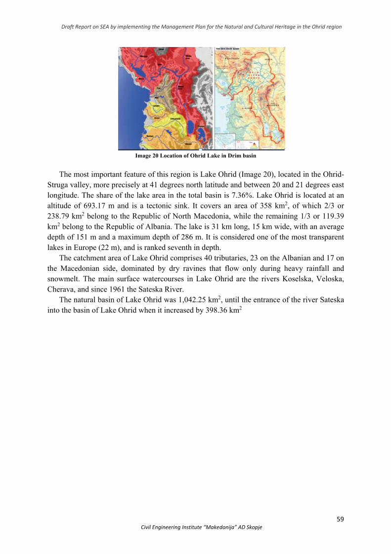
Draft Report on SEA by implementing the Management Plan for the Natural and Cultural Heritage in the Ohrid region
59 Civil Engineering Institute “Makedonija” AD Skopje
Image 20 Location of Ohrid Lake in Drim basin
The most important feature of this region is Lake Ohrid (Image 20), located in the Ohrid-Struga valley, more precisely at 41 degrees north latitude and between 20 and 21 degrees east longitude. The share of the lake area in the total basin is 7.36%. Lake Ohrid is located at an altitude of 693.17 m and is a tectonic sink. It covers an area of 358 km2, of which 2/3 or 238.79 km2 belong to the Republic of North Macedonia, while the remaining 1/3 or 119.39 km2 belong to the Republic of Albania. The lake is 31 km long, 15 km wide, with an average depth of 151 m and a maximum depth of 286 m. It is considered one of the most transparent lakes in Europe (22 m), and is ranked seventh in depth.
The catchment area of Lake Ohrid comprises 40 tributaries, 23 on the Albanian and 17 on the Macedonian side, dominated by dry ravines that flow only during heavy rainfall and snowmelt. The main surface watercourses in Lake Ohrid are the rivers Koselska, Veloska, Cherava, and since 1961 the Sateska River.
The natural basin of Lake Ohrid was 1,042.25 km2, until the entrance of the river Sateska into the basin of Lake Ohrid when it increased by 398.36 km2
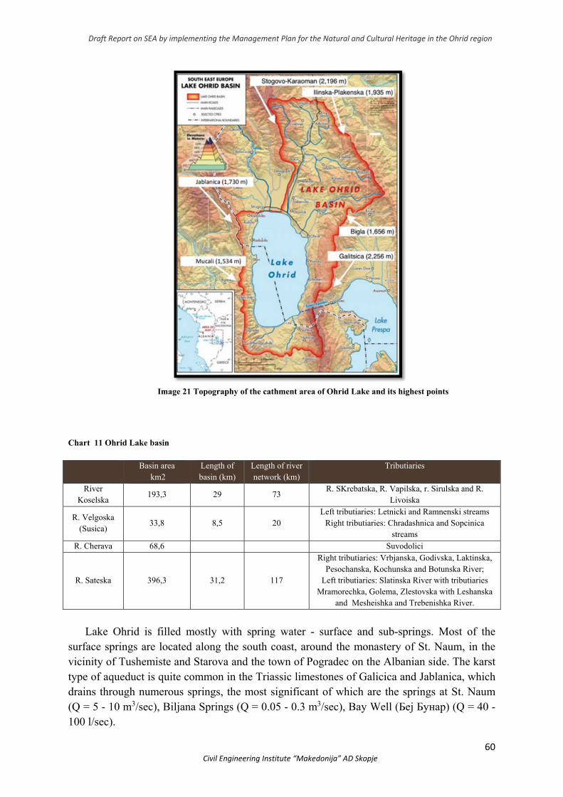
Draft Report on SEA by implementing the Management Plan for the Natural and Cultural Heritage in the Ohrid region
60 Civil Engineering Institute “Makedonija” AD Skopje
Image 21 Topography of the cathment area of Ohrid Lake and its highest points
Chart 11 Ohrid Lake basin
Basin area km2
Length of basin (km)
Length of river network (km)
Tributiaries
River Koselska
193,3 29 73 R. SKrebatska, R. Vapilska, r. Sirulska and R.
Livoiska
R. Velgoska (Susica)
33,8 8,5 20 Left tributiaries: Letnicki and Ramnenski streams
Right tributiaries: Chradashnica and Sopcinica streams
R. Cherava 68,6 Suvodolici
R. Sateska 396,3 31,2 117
Right tributiaries: Vrbjanska, Godivska, Laktinska, Pesochanska, Kochunska and Botunska River;
Left tributiaries: Slatinska River with tributiaries Mramorechka, Golema, Zlestovska with Leshanska
and Mesheishka and Trebenishka River.
Lake Ohrid is filled mostly with spring water - surface and sub-springs. Most of the
surface springs are located along the south coast, around the monastery of St. Naum, in the vicinity of Tushemiste and Starova and the town of Pogradec on the Albanian side. The karst type of aqueduct is quite common in the Triassic limestones of Galicica and Jablanica, which drains through numerous springs, the most significant of which are the springs at St. Naum (Q = 5 - 10 m3/sec), Biljana Springs (Q = 0.05 - 0.3 m3/sec), Bay Well (Беј Бунар) (Q = 40 - 100 l/sec).
Draft Report on SEA by implementing the Management Plan for the Natural and Cultural Heritage in the Ohrid region
61 Civil Engineering Institute “Makedonija” AD Skopje
In the offshore part plain of Ohridsko Pole, as well as between Ljubanista and St. Naum,
high groundwater is still under-research and unidentified. About 20 sources have been registered in this area so far, 5 of which are with power of 1-2 l/sec, 2 with power of less than 1 l/sec. Karst spring in Ohrid, Sveti Naum and Velgoshti reach up to 20 l/sec.
The coastal lake belt is exposed to the damaging effects of torrential waters or the flooding of torrential drifts that occur as a result of erosion. These phenomena are manifested due to the geological background, topographic conditions, expressed through steep slopes and the absence of a good vegetation roof, either grassland or forest. On the Ohrid - Gorica - Pestani stretch under the slopes of the mountain Galicica, 5 downpours with an area of 22.6 km2 have been registered, which have no existing river basin and occasionally transport deposits of larger materials as a result of crushing the unresistant layer.
Two-thirds of the water coming out of Lake Ohrid flows into River Crni Drim in the town
of Struga (Watzin et al. 2002) and then flows into the Adriatic Sea to the north via Lake Skadar. Since 1962, the outflow of the river has been controlled, regulating the water level. According to the 1962 agreement between Yugoslavia and Albania, the maximum water level in Lake Ohrid is not allowed to exceed 693 m of water and the minimum water level to fall below 691.65 m of water (Watzin et al. 2002). The rest (one third) of lake water is lost through evaporation (Watzin et al. 2002). The presence of the lake conditions a number of implications in terms of natural features and commercial significance. Lake Ohrid has long been known as a superlative natural phenomenon. With a geological and biological history of 2-5 million years, it stands out as the oldest natural lake in Europe and one of the oldest lakes in the world. The lake basin supports an equally rich and significant biodiversity and a large number of endemic species. This aquatic ecosystem from a scientific standpoint is among the most important aquatic ecosystems, such as Lake Ohrid and Tanganyika. This superlative natural phenomenon is characterized by the following outstanding universal values:
With an average depth of 155 meters, Lake Ohrid is the deepest lake on the Balkan Peninsula and in Europe; and according to the average depth is the fourteenth in the world.
It is the last remnant of the ancient water region of the Eurasian continent before the Ice Age and according to its geological and biological history is one of the oldest lakes in Europe.
It is an extreme hotspot of biodiversity of global importance. With 212 endemic species of flora and fauna and an area of 358.2 km2, it is probably the most diverse lake in the world, in terms of endemic species per unit area. Living fossils and endemic species have developed as the sole result of geographical isolation and uninterrupted biological activity. This endemism of Lake Ohrid encompasses snails, turbellaria, numerous algae and diatom relics, lake sponges, algae, fish, and 87 species of birds. Vegetation debris is also present in wetland vegetation of glacial origin, as a unique example of the Balkan Peninsula, as well as in aquatic vegetation (eg Silicate Algae).
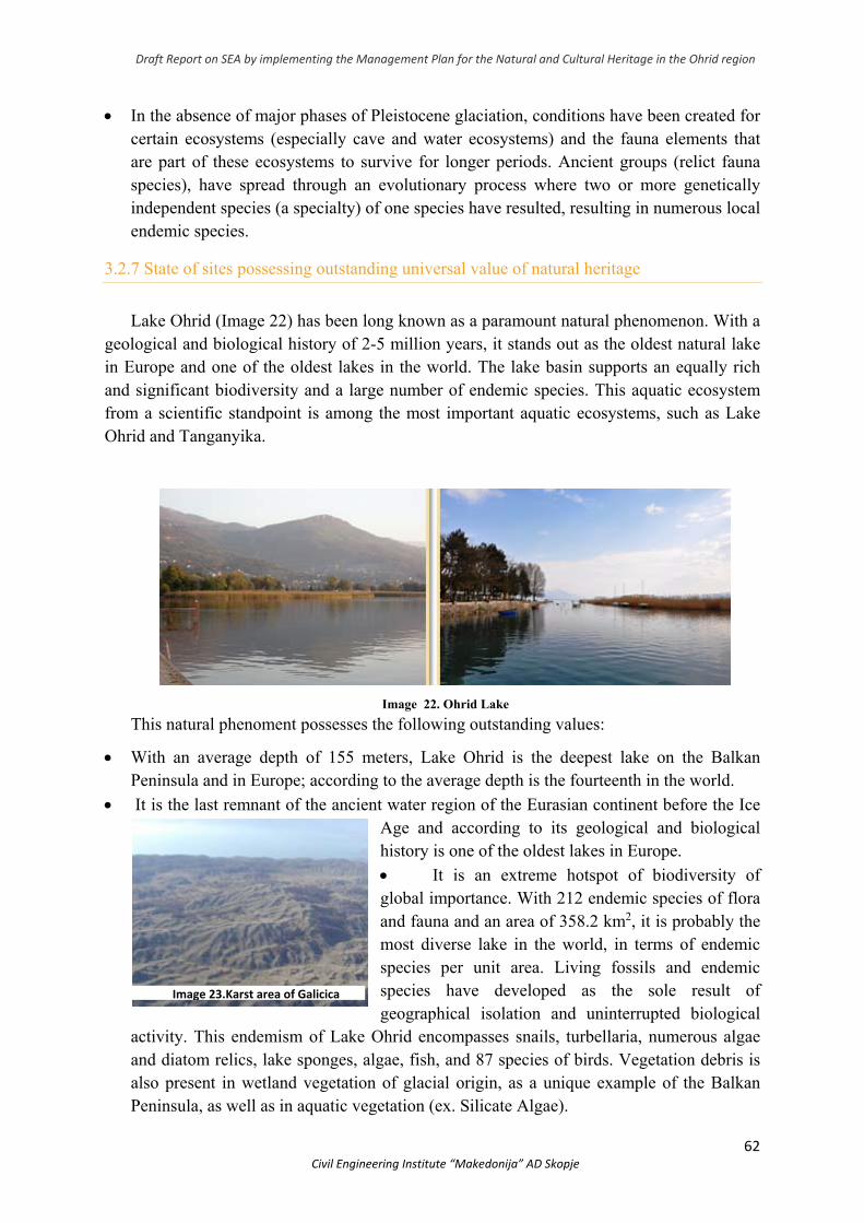
Draft Report on SEA by implementing the Management Plan for the Natural and Cultural Heritage in the Ohrid region
62 Civil Engineering Institute “Makedonija” AD Skopje
In the absence of major phases of Pleistocene glaciation, conditions have been created for certain ecosystems (especially cave and water ecosystems) and the fauna elements that are part of these ecosystems to survive for longer periods. Ancient groups (relict fauna species), have spread through an evolutionary process where two or more genetically independent species (a specialty) of one species have resulted, resulting in numerous local endemic species.
3.2.7 State of sites possessing outstanding universal value of natural heritage
Lake Ohrid (Image 22) has been long known as a paramount natural phenomenon. With a geological and biological history of 2-5 million years, it stands out as the oldest natural lake in Europe and one of the oldest lakes in the world. The lake basin supports an equally rich and significant biodiversity and a large number of endemic species. This aquatic ecosystem from a scientific standpoint is among the most important aquatic ecosystems, such as Lake Ohrid and Tanganyika.
Image 22. Ohrid Lake
This natural phenoment possesses the following outstanding values:
With an average depth of 155 meters, Lake Ohrid is the deepest lake on the Balkan Peninsula and in Europe; according to the average depth is the fourteenth in the world.
It is the last remnant of the ancient water region of the Eurasian continent before the Ice Age and according to its geological and biological history is one of the oldest lakes in Europe.
It is an extreme hotspot of biodiversity of global importance. With 212 endemic species of flora and fauna and an area of 358.2 km2, it is probably the most diverse lake in the world, in terms of endemic species per unit area. Living fossils and endemic species have developed as the sole result of geographical isolation and uninterrupted biological
activity. This endemism of Lake Ohrid encompasses snails, turbellaria, numerous algae and diatom relics, lake sponges, algae, fish, and 87 species of birds. Vegetation debris is also present in wetland vegetation of glacial origin, as a unique example of the Balkan Peninsula, as well as in aquatic vegetation (ex. Silicate Algae).
Image 23.Karst area of Galicica
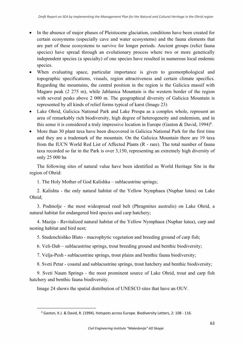
Draft Report on SEA by implementing the Management Plan for the Natural and Cultural Heritage in the Ohrid region
63 Civil Engineering Institute “Makedonija” AD Skopje
In the absence of major phases of Pleistocene glaciation, conditions have been created for certain ecosystems (especially cave and water ecosystems) and the fauna elements that are part of these ecosystems to survive for longer periods. Ancient groups (relict fauna species) have spread through an evolutionary process where two or more genetically independent species (a specialty) of one species have resulted in numerous local endemic species.
When evaluating space, particular importance is given to geomorphological and topographic specifications, visuals, region attractiveness and certain climate specifics. Regarding the mountains, the central position in the region is the Galicica massif with Magaro peak (2 275 m), while Jablanica Mountain is the western border of the region with several peaks above 2 000 m. The geographical diversity of Galicica Mountain is represented by all kinds of relief forms typical of karst (Image 23)
Lake Ohrid, Galicica National Park and Lake Prespa as a complex whole, represent an area of remarkably rich biodiversity, high degree of heterogeneity and endemism, and in this sense it is considered a truly impressive location in Europe (Gaston & David, 1994)6.
More than 30 plant taxa have been discovered in Galicica National Park for the first time and they are a trademark of the mountain. On the Galicica Mountain there are 19 taxa from the IUCN World Red List of Affected Plants (R - rare). The total number of fauna taxa recorded so far in the Park is over 3,150, representing an extremely high diversity of only 25 000 ha
The following sites of natural value have been identified as World Heritage Site in the region of Ohrid:
1. The Holy Mother of God Kalishka – sublacustrine springs;
2. Kalishta - the only natural habitat of the Yellow Nymphaea (Nuphar lutea) on Lake Ohrid;
3. Podmolje - the most widespread reed belt (Phragmites australis) on Lake Ohrid, a natural habitat for endangered bird species and carp hatchery;
4. Mazija - Revitalized natural habitat of the Yellow Nymphaea (Nuphar lutea), carp and nesting habitat and bird nest;
5. Studenchishko Blato - macrophytic vegetation and breeding ground of carp fish;
6. Veli-Dab – sublacustrine springs, trout breeding ground and benthic biodiversity;
7. Velja-Pesh - sublacustrine springs, trout plains and benthic fauna biodiversity;
8. Sveti Petar - coastal and sublacustrine springs, trout hatchery and benthic biodiversity;
9. Sveti Naum Springs - the most prominent source of Lake Ohrid, trout and carp fish hatchery and benthic fauna biodiversity.
Image 24 shows the spatial distribution of UNESCO sites that have an OUV.
6 Gaston, K.J. & David, R. (1994). Hotspots across Europe. Biodiversity Letters, 2: 108 ‐ 116.
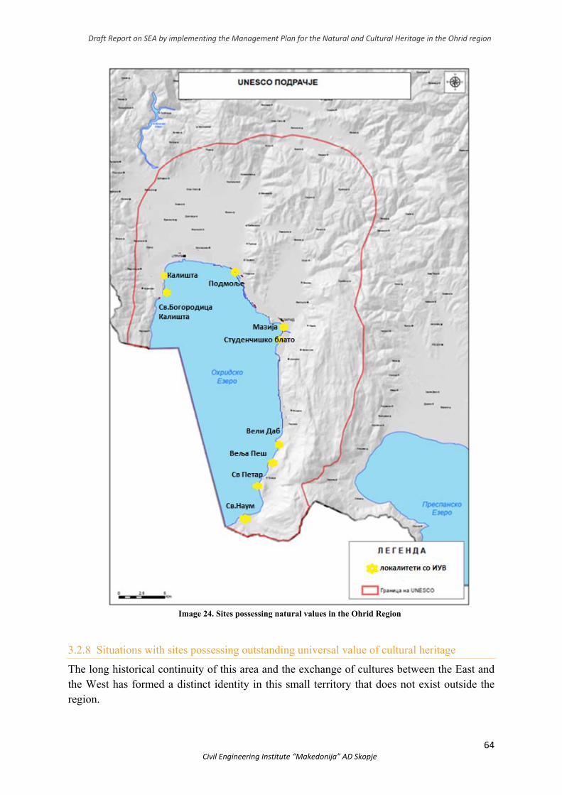
Draft Report on SEA by implementing the Management Plan for the Natural and Cultural Heritage in the Ohrid region
64 Civil Engineering Institute “Makedonija” AD Skopje
Image 24. Sites possessing natural values in the Ohrid Region
3.2.8 Situations with sites possessing outstanding universal value of cultural heritage
The long historical continuity of this area and the exchange of cultures between the East and the West has formed a distinct identity in this small territory that does not exist outside the region.

Draft Report on SEA by implementing the Management Plan for the Natural and Cultural Heritage in the Ohrid region
65 Civil Engineering Institute “Makedonija” AD Skopje
image 25. Sites possessing cultursl values in the Ohrid Region
The quality of the specific architecture and the successful realization of the unity between the towns, settlements and the natural surroundings of the lake make this landscape authentic and therefore extremely valuable.
Having in mind the rich cultural-historical, architectural, archaeological and ethnological values that give the region uniqueness, representativeness, authenticity, with their preservation, diversity and integrality, opportunities have been created for the region to represent well-being of the highest national importance with universal value, humanity and its history, culture, art and science
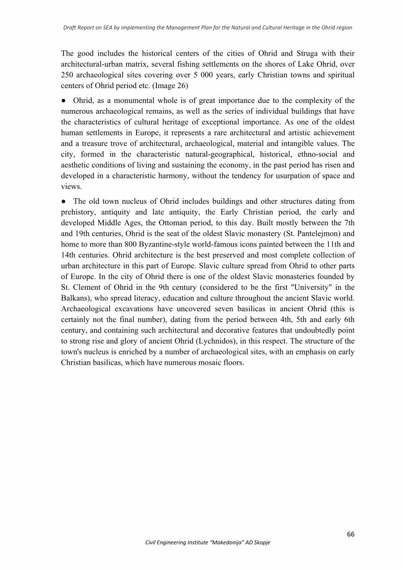
Draft Report on SEA by implementing the Management Plan for the Natural and Cultural Heritage in the Ohrid region
66 Civil Engineering Institute “Makedonija” AD Skopje
The good includes the historical centers of the cities of Ohrid and Struga with their architectural-urban matrix, several fishing settlements on the shores of Lake Ohrid, over 250 archaeological sites covering over 5 000 years, early Christian towns and spiritual centers of Ohrid period etc. (Image 26)
● Ohrid, as a monumental whole is of great importance due to the complexity of the numerous archaeological remains, as well as the series of individual buildings that have the characteristics of cultural heritage of exceptional importance. As one of the oldest human settlements in Europe, it represents a rare architectural and artistic achievement and a treasure trove of architectural, archaeological, material and intangible values. The city, formed in the characteristic natural-geographical, historical, ethno-social and aesthetic conditions of living and sustaining the economy, in the past period has risen and developed in a characteristic harmony, without the tendency for usurpation of space and views.
● The old town nucleus of Ohrid includes buildings and other structures dating from prehistory, antiquity and late antiquity, the Early Christian period, the early and developed Middle Ages, the Ottoman period, to this day. Built mostly between the 7th and 19th centuries, Ohrid is the seat of the oldest Slavic monastery (St. Panteleјmon) and home to more than 800 Byzantine-style world-famous icons painted between the 11th and 14th centuries. Ohrid architecture is the best preserved and most complete collection of urban architecture in this part of Europe. Slavic culture spread from Ohrid to other parts of Europe. In the city of Ohrid there is one of the oldest Slavic monasteries founded by St. Clement of Ohrid in the 9th century (considered to be the first "University" in the Balkans), who spread literacy, education and culture throughout the ancient Slavic world. Archaeological excavations have uncovered seven basilicas in ancient Ohrid (this is certainly not the final number), dating from the period between 4th, 5th and early 6th century, and containing such architectural and decorative features that undoubtedly point to strong rise and glory of ancient Ohrid (Lychnidos), in this respect. The structure of the town's nucleus is enriched by a number of archaeological sites, with an emphasis on early Christian basilicas, which have numerous mosaic floors.
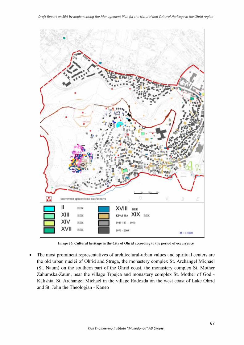
Draft Report on SEA by implementing the Management Plan for the Natural and Cultural Heritage in the Ohrid region
67 Civil Engineering Institute “Makedonija” AD Skopje
Image 26. Cultural heritage in the City of Ohrid according to the period of occurrence
The most prominent representatives of architectural-urban values and spiritual centers are the old urban nuclei of Ohrid and Struga, the monastery complex St. Archangel Michael (St. Naum) on the southern part of the Ohrid coast, the monastery complex St. Mother Zahumska-Zaum, near the village Trpejca and monastery complex St. Mother of God - Kalishta, St. Archangel Michael in the village Radozda on the west coast of Lake Ohrid and St. John the Theologian - Kaneo
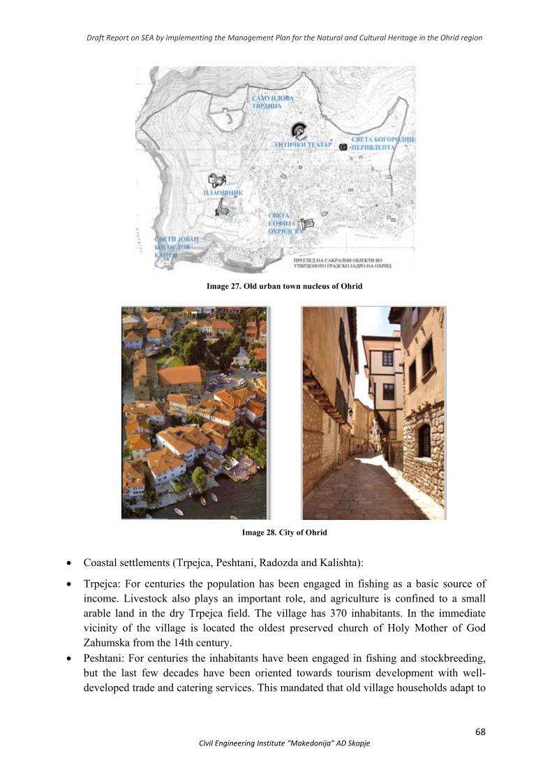
Draft Report on SEA by implementing the Management Plan for the Natural and Cultural Heritage in the Ohrid region
68 Civil Engineering Institute “Makedonija” AD Skopje
Image 27. Old urban town nucleus of Ohrid
Image 28. City of Ohrid
Coastal settlements (Trpejca, Peshtani, Radozda and Kalishta):
Trpejca: For centuries the population has been engaged in fishing as a basic source of income. Livestock also plays an important role, and agriculture is confined to a small arable land in the dry Trpejca field. The village has 370 inhabitants. In the immediate vicinity of the village is located the oldest preserved church of Holy Mother of God Zahumska from the 14th century.
Peshtani: For centuries the inhabitants have been engaged in fishing and stockbreeding, but the last few decades have been oriented towards tourism development with well-developed trade and catering services. This mandated that old village households adapt to
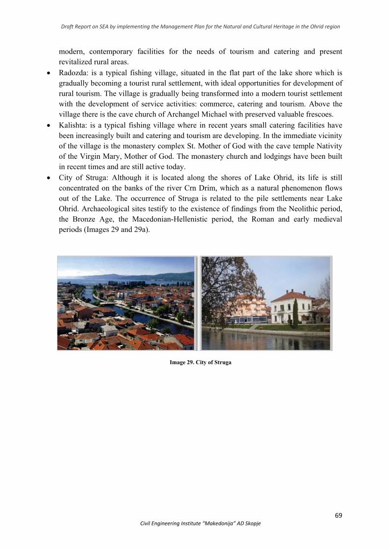
Draft Report on SEA by implementing the Management Plan for the Natural and Cultural Heritage in the Ohrid region
69 Civil Engineering Institute “Makedonija” AD Skopje
modern, contemporary facilities for the needs of tourism and catering and present revitalized rural areas.
Radozda: is a typical fishing village, situated in the flat part of the lake shore which is gradually becoming a tourist rural settlement, with ideal opportunities for development of rural tourism. The village is gradually being transformed into a modern tourist settlement with the development of service activities: commerce, catering and tourism. Above the village there is the cave church of Archangel Michael with preserved valuable frescoes.
Kalishta: is a typical fishing village where in recent years small catering facilities have been increasingly built and catering and tourism are developing. In the immediate vicinity of the village is the monastery complex St. Mother of God with the cave temple Nativity of the Virgin Mary, Mother of God. The monastery church and lodgings have been built in recent times and are still active today.
City of Struga: Although it is located along the shores of Lake Ohrid, its life is still concentrated on the banks of the river Crn Drim, which as a natural phenomenon flows out of the Lake. The occurrence of Struga is related to the pile settlements near Lake Ohrid. Archaeological sites testify to the existence of findings from the Neolithic period, the Bronze Age, the Macedonian-Hellenistic period, the Roman and early medieval periods (Images 29 and 29a).
Image 29. City of Struga
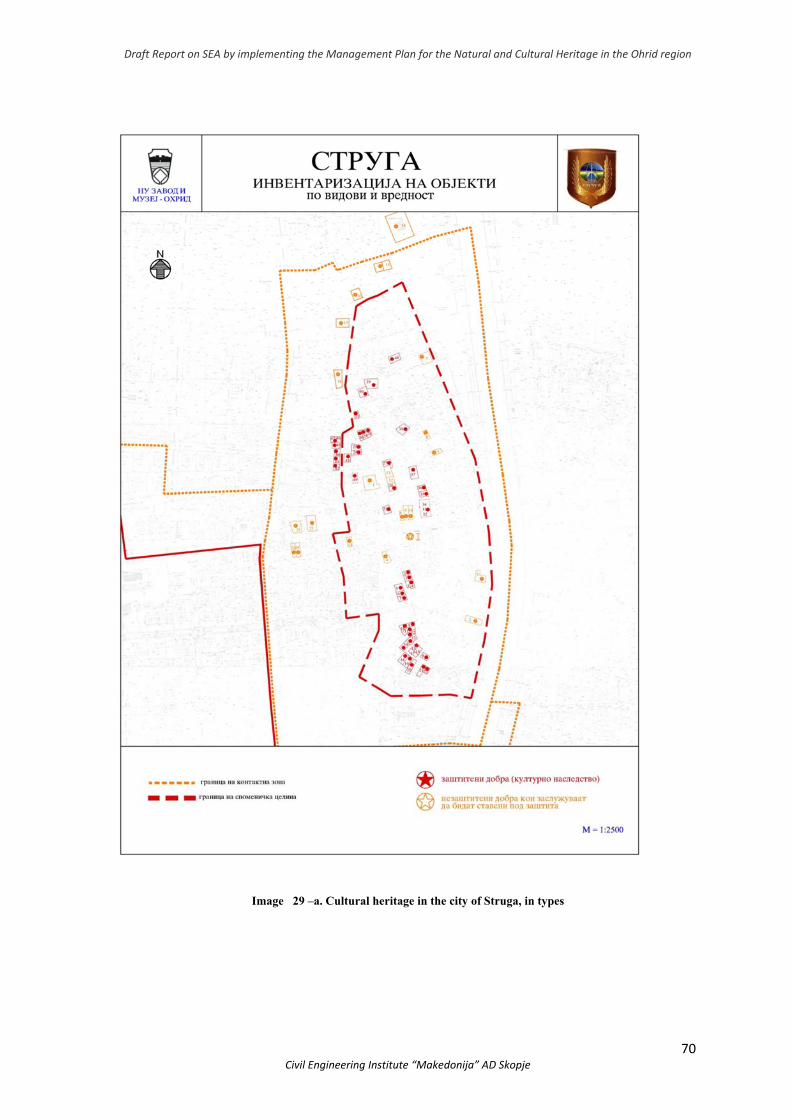
Draft Report on SEA by implementing the Management Plan for the Natural and Cultural Heritage in the Ohrid region
70 Civil Engineering Institute “Makedonija” AD Skopje
Image 29 –а. Cultural heritage in the city of Struga, in types
Draft Report on SEA by implementing the Management Plan for the Natural and Cultural Heritage in the Ohrid region
71 Civil Engineering Institute “Makedonija” AD Skopje
● According to the relief features, the municipality of Debrca is one of the hilly municipalities and part of its territory belongs to the boundaries of the protected natural and cultural heritage of the Ohrid region. The concentration of archaeological sites with significant archaeological findings reflects the importance that this territory has had in the past but also the contribution to completing the image of the region's authentic universal value. The identified archaeological sites on the territory of the municipality of Debrca belong to different time periods, from which we would distinguish: Trebenishka Necropola, Gorenci, 8-4 century BC (known for rich archaeological material - gold death masks discovered), Trebenishko Kale, Trebenista (ancient period), Zla Strana, Gorno Sredorechje (Neolithic), Kutlina, Velmej (Neolithic until 6th century), Suva Chesma, Tri Chelusti, Gorenci (8-4 BC), Cherepec, Godivje, Cave of Jaorec, Velmej (traces of primitive communities found). Religious heritage (14th century church of St. Sveti in village Leshani) and some commercial buildings (water mill in village Leshani) are only part of the rich cultural heritage that this region possesses
3.3 Environmental management
3.3.1 Water resources and water management
Water supply to the population In the Ohrid region only the towns and villages in their vicinity have organized water
supply through regional water supply systems. The water supply of the other villages is predominantly local - each village has its own water supply system and the waters are covered by local springs or wells. Often these systems are with low capacity and do not cover the needs, maintenance of the source and the network are insufficient, and problems with regular water supply often occur.
In the Municipality of Ohrid, out of a total of 29 villages, only the town of Ohrid, the villages and localities of Peshtani, Eleshec, Lagadin, Dolno Konjsko, Istok, Sveti Stefan, Racha and Orman are supplied by the common system - Ohrid water supply system.
The Ohrid water supply system covers waters from Lake Ohrid, from springs and wells. The amount of water consumed by Letnichki Springs is 30-100 l/sec, Biljana Springs and Bejbunar are 45 l/sec; Lake Ohrid then covers 200 l/sec and Studenchista wells 2x45 l/sec.
In the Municipality of Struga, the City of Struga and 21 other villages (out of 54 villages) are supplied through the Struga water supply system. The Struga water supply system covers a total of 430 l/sec from the sources: Shum, Gorna Belica, Radolishta, Radozda and Tash Morunishta. Villages that are connected to the Struga water supply system are: Biljevo, Vranishte, Gorna and Dolna Belica, Drslajca, Zagrachani, Kalishta, Lozani, Mali Vlaj, Misleshevo, Moroishta, Radozda, Radolishta, Shum, Velishta, Gorno and Dolno Tateshi , Dobovjani, Tashmarunishta, Livada and Novo Selo.

Draft Report on SEA by implementing the Management Plan for the Natural and Cultural Heritage in the Ohrid region
72 Civil Engineering Institute “Makedonija” AD Skopje
In Debrca municipality most of the villages are supplied from local sources, and in 8 villages - Gorno Sredorechie, Dolno Sredorechie, Grko Pole, Mamororec, Novo Selo, Slatinski Chiflik, Soshani and Crvena Voda there is no water supply.
To improve the water supply, a regional water supply "Radomirovo" was built, which will be joined by the villages of Gorno Sredorechie, Dolno Sredorechie, Grko Pole and Novo Selo. The water supply system for the regional water supply system is taken from springs near HPP "Pesochanka".
Irrigation The Ohrid-Prespa region irrigates 7,645 ha. arable land for which 45,589 x 103m3/yr of
water need to be provided. The main sources of irrigation are Lake Ohrid, Lake Prespa, Crn Drim, Sateska and Koselska rivers.
Dams and reservoirs In order to improve the water use regime by quantity, quality and time, the reservoirs are
important facilities in the water economy. In the Republic of North Macedonia there are 21 reservoirs, out of which Globochica and Slatino reservoirs are built in the Ohrid region. Lake Ohrid, with a partition of the Crn Drim river at Struga, which controls the outflow from the Lake, has actually been converted into a reservoir with a useful volume of 227.5 x 10⁶ m3.
3.3.2 Air quality management
The main emission points that affect air pollution in the Ohrid region are as follows: industrial and commercial buildings, as well as households and hotel heating (wood, oil, etc.) in the winter.
Road traffic is a major mobile source of air pollution. In addition, in summer the water traffic is another mobile source of air pollution in the municipalities of the region.
In September 2019 under the AIRTHINGS EU INTERREG PROJECT, BALKAN MEDITERRANEAN PROGRAM, the Municipality of Ohrid became part of the network of cities Sofia, Thessaloniki, Tirana and Nicosia. North Macedonia's partner is the State Environmental Inspectorate, the first of 11 sensors for indicative monitoring of environmental air quality parameters installed in the pilot municipality, Ohrid (Image. 30).
Aero sediments are important because they have an impact on natural and cultural heritage. Particles deposited on vegetation can inhibit normal respiration and leaf photosynthesis. Dust can cause chlorosis combined with the appearance of thick bark and alkaline toxicity produced in wet weather conditions.
Monuments of great cultural and artistic interest are often located in areas where anthropogenic activity is not negligible (in the downtown areas of Ohrid and Struga). As a result of air pollution, emissions from industrial plants and public transport, there is damage to buildings and exteriors.7.
7 Cultural heritage and its environment: an issue of interest for Environmental Science and Pollution
Research
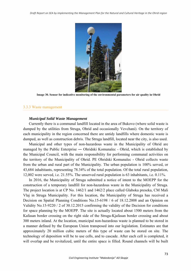
Draft Report on SEA by implementing the Management Plan for the Natural and Cultural Heritage in the Ohrid region
73 Civil Engineering Institute “Makedonija” AD Skopje
Image 30. Sensor for indicative monitoring of the environmental parameters for air quality in Ohrid
3.3.3 Waste management
Municipal Solid Waste Management Currently there is a communal landfill located in the area of Bukovo (where solid waste is
dumped by the utilities from Struga, Ohrid and occasionally Vevchani). On the territory of each municipality in the region concerned there are untidy landfills where domestic waste is dumped, as well as construction debris. The Struga landfill, located near the city, is also used.
Municipal and other types of non-hazardous waste in the Municipality of Ohrid are managed by the Public Enterprise ― Ohridski Komunalec - Ohrid, which is established by the Municipal Council, with the main responsibility for performing communal activities on the territory of the Municipality of Ohrid. PE Ohridski Komunalec - Ohrid collects waste from the urban and rural part of the Municipality. The urban population is 100% served, or 43,684 inhabitants, representing 78.34% of the total population. Of the total rural population, 12,002 were served, i.e. 21.55%. The unserved rural population is 63 inhabitants, i.e. 0.11%.
In 2016, the Municipality of Struga submitted a notice of intent to the MOEPP for the construction of a temporary landfill for non-hazardous waste in the Municipality of Struga. The project location is at CP No. 1462/1 and 1462/2 place called Glaboka preseka, CM Mali Vlaj in Struga Municipality. For this location, the Municipality of Struga has received a Decision on Spatial Planning Conditions No.15-6198 / 6 of 18.12.2008 and an Opinion on Validity No.15-9220 / 2 of 30.12.2015 confirming the validity of the Decision for conditions for space planning by the MOEPP. The site is actually located about 1500 meters from the Kafasan border crossing on the right side of the Struga-Kjafasan border crossing and about 300 meters inland. At the location, municipal non-hazardous waste is planned to be stored in a manner defined by the European Union transposed into our legislation. Estimates are that approximately 20 million cubic meters of this type of waste can be stored on site. The technology of deposition will be to use cells, and to cascade. After each cell is completed, it will overlap and be revitalized, until the entire space is filled. Round channels will be built
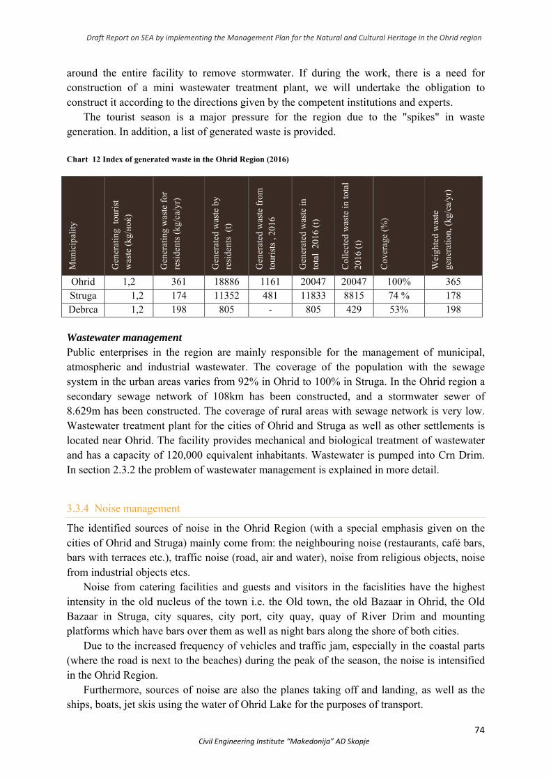
Draft Report on SEA by implementing the Management Plan for the Natural and Cultural Heritage in the Ohrid region
74 Civil Engineering Institute “Makedonija” AD Skopje
around the entire facility to remove stormwater. If during the work, there is a need for construction of a mini wastewater treatment plant, we will undertake the obligation to construct it according to the directions given by the competent institutions and experts.
The tourist season is a major pressure for the region due to the "spikes" in waste generation. In addition, a list of generated waste is provided.
Chart 12 Index of generated waste in the Ohrid Region (2016)
Mun
icip
ality
Gen
erat
ing
tour
ist
was
te (
kg/ноќ
)
Gen
erat
ing
was
te f
or
resi
dent
s (k
g/ca
/yr)
Gen
erat
ed w
aste
by
resi
dent
s (
t)
Gen
erat
ed w
aste
fro
m
tour
ists
, 20
16
Gen
erat
ed w
aste
in
tota
l 20
16 (
t)
Col
lect
ed w
aste
in to
tal
2016
(t)
Cov
erag
e (%
)
Wei
ghte
d w
aste
ge
nera
tion,
(kg
/ca/
yr)
Ohrid 1,2 361 18886 1161 20047 20047 100% 365 Struga 1,2 174 11352 481 11833 8815 74 % 178 Debrca 1,2 198 805 - 805 429 53% 198
Wastewater management Public enterprises in the region are mainly responsible for the management of municipal, atmospheric and industrial wastewater. The coverage of the population with the sewage system in the urban areas varies from 92% in Ohrid to 100% in Struga. In the Ohrid region a secondary sewage network of 108km has been constructed, and a stormwater sewer of 8.629m has been constructed. The coverage of rural areas with sewage network is very low. Wastewater treatment plant for the cities of Ohrid and Struga as well as other settlements is located near Ohrid. The facility provides mechanical and biological treatment of wastewater and has a capacity of 120,000 equivalent inhabitants. Wastewater is pumped into Crn Drim. In section 2.3.2 the problem of wastewater management is explained in more detail.
3.3.4 Noise management
The identified sources of noise in the Ohrid Region (with a special emphasis given on the cities of Ohrid and Struga) mainly come from: the neighbouring noise (restaurants, café bars, bars with terraces etc.), traffic noise (road, air and water), noise from religious objects, noise from industrial objects etcs.
Noise from catering facilities and guests and visitors in the facislities have the highest intensity in the old nucleus of the town i.e. the Old town, the old Bazaar in Ohrid, the Old Bazaar in Struga, city squares, city port, city quay, quay of River Drim and mounting platforms which have bars over them as well as night bars along the shore of both cities.
Due to the increased frequency of vehicles and traffic jam, especially in the coastal parts (where the road is next to the beaches) during the peak of the season, the noise is intensified in the Ohrid Region.
Furthermore, sources of noise are also the planes taking off and landing, as well as the ships, boats, jet skis using the water of Ohrid Lake for the purposes of transport.
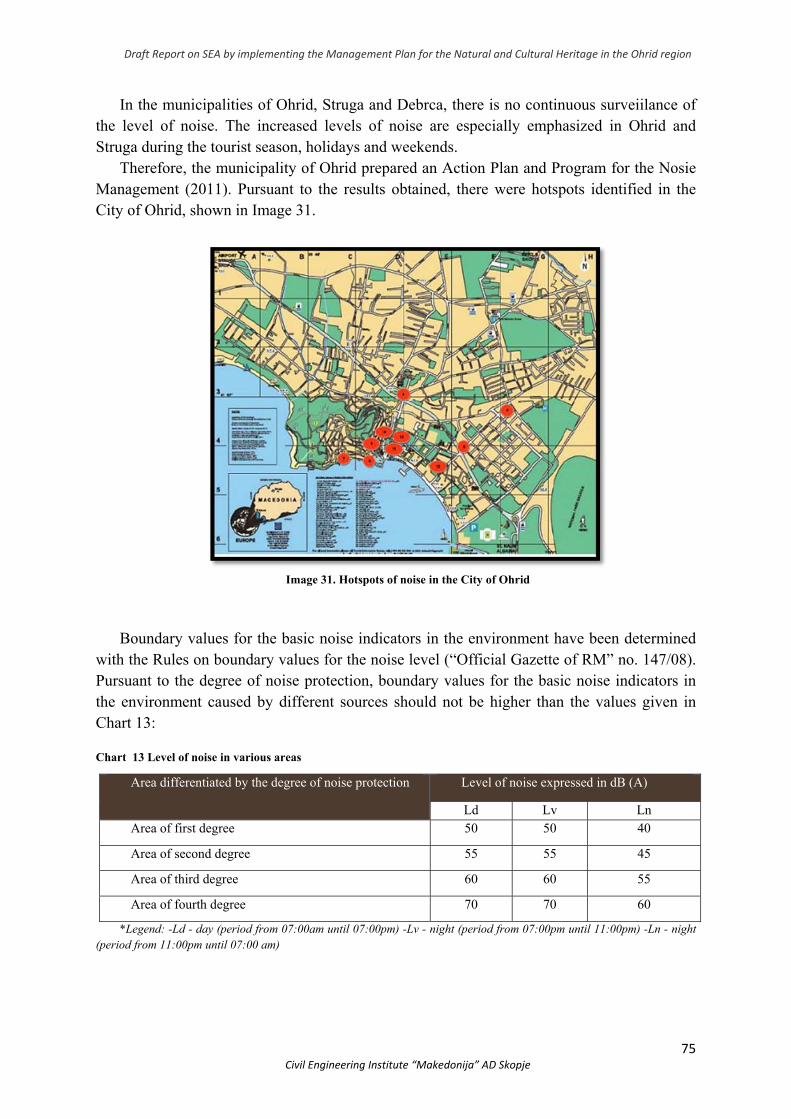
Draft Report on SEA by implementing the Management Plan for the Natural and Cultural Heritage in the Ohrid region
75 Civil Engineering Institute “Makedonija” AD Skopje
In the municipalities of Ohrid, Struga and Debrca, there is no continuous surveiilance of the level of noise. The increased levels of noise are especially emphasized in Ohrid and Struga during the tourist season, holidays and weekends.
Therefore, the municipality of Ohrid prepared an Action Plan and Program for the Nosie Management (2011). Pursuant to the results obtained, there were hotspots identified in the City of Ohrid, shown in Image 31.
Image 31. Hotspots of noise in the City of Ohrid
Boundary values for the basic noise indicators in the environment have been determined
with the Rules on boundary values for the noise level (“Official Gazette of RM” no. 147/08). Pursuant to the degree of noise protection, boundary values for the basic noise indicators in the environment caused by different sources should not be higher than the values given in Chart 13: Chart 13 Level of noise in various areas
*Legend: -Ld - day (period from 07:00am until 07:00pm) -Lv - night (period from 07:00pm until 11:00pm) -Ln - night (period from 11:00pm until 07:00 am)
Area differentiated by the degree of noise protection Level of noise expressed in dB (A)
Ld Lv Ln Area of first degree 50 50 40
Area of second degree 55 55 45
Area of third degree 60 60 55
Area of fourth degree 70 70 60
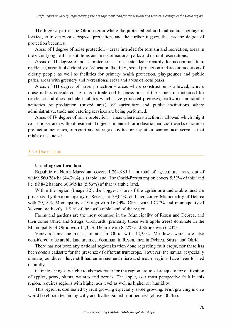
Draft Report on SEA by implementing the Management Plan for the Natural and Cultural Heritage in the Ohrid region
76 Civil Engineering Institute “Makedonija” AD Skopje
The biggest part of the Ohrid region where the protected cultural and natural heritage is located, is in areas of I degree protection, and the further it goes, the less the degree of protection becomes.
Areas of I degree of noise protection – areas intended for toruism and recreation, areas in the vicinity og health institutions and areas of national parks and natural reservations;
Areas of II degree of noise protection – areas intended primarily for accommodation, residence, areas in the vicinity of education facilities, social protection and accommodation of elderly people as well as facilities for primary health protection, playgrounds and public parks, areas with greenery and recreational areas and areas of local parks.
Areas of III degree of noise protection – areas where construction is allowed, whrere noise is less considered i.e. it is a trede and business area at the same time intended for residence and does include facilities which have protected premises, craftwork and similar activities of production (mixed area), of agriculture and public institutions where administrative, trade and catering services are being performed.
Areas of IV degree of noise protection – areas where construction is allowed which might cause noise, area without residential objects, intended for industrial and craft works or similar production activities, transport and storage activities or any other scommuncal servoise that might cause noise.
3.3.5 Use of land
Use of agricultural land Republic of North Macedona covers 1.264.985 ha in total of agriculture areas, out of
which 560.264 ha (44,29%) is arable land. The Ohrid-Prespa region covers 5,52% of this land i.e. 69.842 ha; and 30.995 ha (5,53%) of that is arable land.
Within the region (Image 32), the boggest share of the agriculture and arable land are possessed by the municipality of Resen, i.e. 39,05%, and then comes Municipality of Debrca with 29,18%, Municipality of Struga with 16,74%, Ohrid with 13,77% and municipality of Vevcani with only 1,51% of the total arable land of the region.
Farms and gardens are the most common in the Municipality of Resen and Debrca, and then come Ohrid and Struga. Orchyards (primarily those with apple trees) dominate in the Municipality of Ohrid with 15,35%, Debrca with 8,72% and Struga with 6,23% .
Vineyards are the most common in Ohrid with 42,35%. Meadows which are also considered to be arable land are most dominant in Resen, then in Debrca, Struga and Ohrid.
There has not been any national regionalization done regarding fruit crops, nor there has been done a cadastre for the presence of different fruit crops. However, the natural (especially climate) conditions have still had an impact and micro and macro regions have been formed naturally.
Climate changes which are characteristic for the region are most adequate for cultivation of apples, pears, plums, walnuts and berries. The apple, as a most perspective fruit in this region, requires regions with higher sea level as well as higher air humidity.
This region is dominated by fruit growing especially apple growing. Fruit growing is on a world level both technologically and by the gained fruit per area (above 40 t/ha).
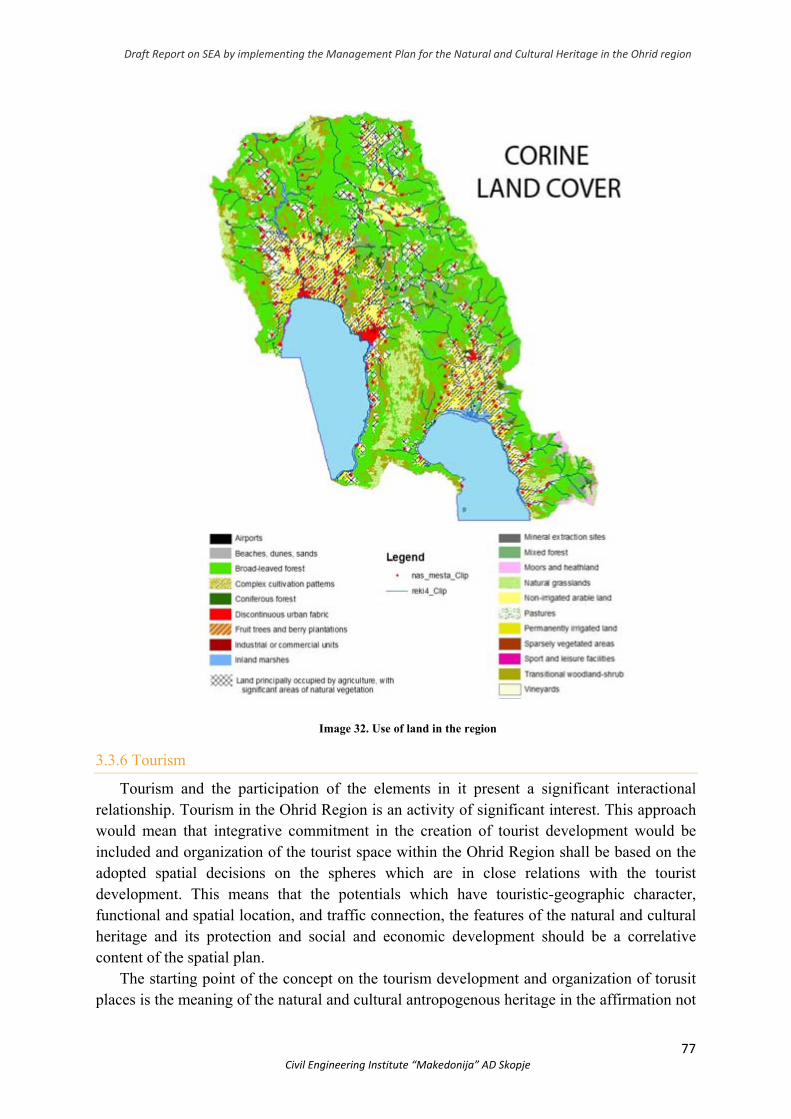
Draft Report on SEA by implementing the Management Plan for the Natural and Cultural Heritage in the Ohrid region
77 Civil Engineering Institute “Makedonija” AD Skopje
Image 32. Use of land in the region
3.3.6 Tourism
Tourism and the participation of the elements in it present a significant interactional relationship. Tourism in the Ohrid Region is an activity of significant interest. This approach would mean that integrative commitment in the creation of tourist development would be included and organization of the tourist space within the Ohrid Region shall be based on the adopted spatial decisions on the spheres which are in close relations with the tourist development. This means that the potentials which have touristic-geographic character, functional and spatial location, and traffic connection, the features of the natural and cultural heritage and its protection and social and economic development should be a correlative content of the spatial plan.
The starting point of the concept on the tourism development and organization of torusit places is the meaning of the natural and cultural antropogenous heritage in the affirmation not
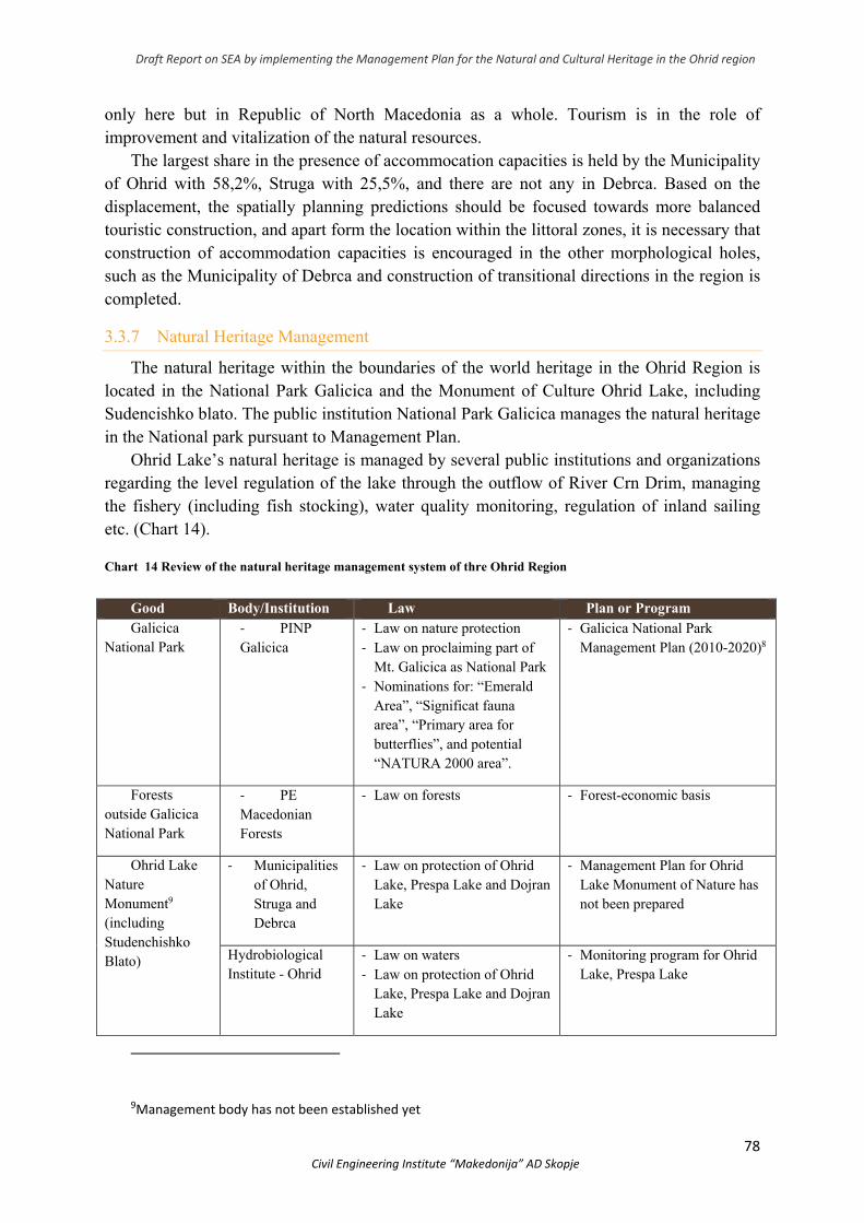
Draft Report on SEA by implementing the Management Plan for the Natural and Cultural Heritage in the Ohrid region
78 Civil Engineering Institute “Makedonija” AD Skopje
only here but in Republic of North Macedonia as a whole. Tourism is in the role of improvement and vitalization of the natural resources.
The largest share in the presence of accommocation capacities is held by the Municipality of Ohrid with 58,2%, Struga with 25,5%, and there are not any in Debrca. Based on the displacement, the spatially planning predictions should be focused towards more balanced touristic construction, and apart form the location within the littoral zones, it is necessary that construction of accommodation capacities is encouraged in the other morphological holes, such as the Municipality of Debrca and construction of transitional directions in the region is completed.
3.3.7 Natural Heritage Management
The natural heritage within the boundaries of the world heritage in the Ohrid Region is located in the National Park Galicica and the Monument of Culture Ohrid Lake, including Sudencishko blato. The public institution National Park Galicica manages the natural heritage in the National park pursuant to Management Plan.
Ohrid Lake’s natural heritage is managed by several public institutions and organizations regarding the level regulation of the lake through the outflow of River Crn Drim, managing the fishery (including fish stocking), water quality monitoring, regulation of inland sailing etc. (Chart 14). Chart 14 Review of the natural heritage management system of thre Ohrid Region
Good Body/Institution Law Plan or Program Galicica
National Park ‐ PINP Galicica
‐ Law on nature protection ‐ Law on proclaiming part of
Mt. Galicica as National Park ‐ Nominations for: “Emerald
Area”, “Significat fauna area”, “Primary area for butterflies”, and potential “NATURA 2000 area”.
‐ Galicica National Park Management Plan (2010-2020)8
Forests outside Galicica National Park
‐ PE Macedonian Forests
‐ Law on forests ‐ Forest-economic basis
Ohrid Lake Nature Monument9 (including Studenchishko Blato)
‐ Municipalities of Ohrid, Struga and Debrca
‐ Law on protection of Ohrid Lake, Prespa Lake and Dojran Lake
‐ Management Plan for Ohrid Lake Monument of Nature has not been prepared
Hydrobiological Institute - Ohrid
‐ Law on waters ‐ Law on protection of Ohrid
Lake, Prespa Lake and Dojran Lake
‐ Monitoring program for Ohrid Lake, Prespa Lake
9Management body has not been established yet
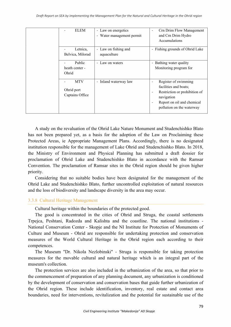
Draft Report on SEA by implementing the Management Plan for the Natural and Cultural Heritage in the Ohrid region
79 Civil Engineering Institute “Makedonija” AD Skopje
‐ ELEM ‐ Law on energetics ‐ Water management permit
‐ Crn Drim Flow Management and Crn Drim Hydro Accumulations
‐ Letnica, Belvica, Milorad
‐ Law on fishing and aquaculture
‐ Fishing grounds of Ohrid Lake
‐ Public heath center - Ohrid
‐ Law on waters ‐ Bathing water quality Monitoring program for
‐ MTV
Ohrid port Captains Office
‐ Inland waterway law ‐ Register of swimming facilities and boats;
‐ Restriction or prohibition of navigation
‐ Report on oil and chemical pollution on the waterway
A study on the revaluation of the Ohrid Lake Nature Monument and Studenchishko Blato
has not been prepared yet, as a basis for the adoption of the Law on Proclaiming these Protected Areas, ie Appropriate Management Plans. Accordingly, there is no designated institution responsible for the management of Lake Ohrid and Studenchishko Blato. In 2018, the Ministry of Environment and Physical Planning has submitted a draft dossier for proclamation of Ohrid Lake and Studenchishko Blato in accordance with the Ramsar Convention. The proclamation of Ramsar sites in the Ohrid region should be given higher priority.
Considering that no suitable bodies have been designated for the management of the Ohrid Lake and Studenchishko Blato, further uncontrolled exploitation of natural resources and the loss of biodiversity and landscape diversity in the area may occur.
3.3.8 Cultural Heritage Management
Cultural heritage within the boundaries of the protected good. The good is concentrated in the cities of Ohrid and Struga, the coastal settlements
Trpejca, Peshtani, Radozda and Kalishta and the coastline. The national institutions - National Conservation Center - Skopje and the NI Institute for Protection of Monuments of Culture and Museum - Ohrid are responsible for undertaking protection and conservation measures of the World Cultural Heritage in the Ohrid region each according to their competences.
The Museum "Dr. Nikola Nezlobinski" - Struga is responsible for taking protection measures for the movable cultural and natural heritage which is an integral part of the museum's collection.
The protection services are also included in the urbanization of the area, so that prior to the commencement of preparation of any planning document, any urbanization is conditioned by the development of conservation and conservation bases that guide further urbanization of the Ohrid region. These include identification, inventory, real estate and contact area boundaries, need for interventions, revitalization and the potential for sustainable use of the
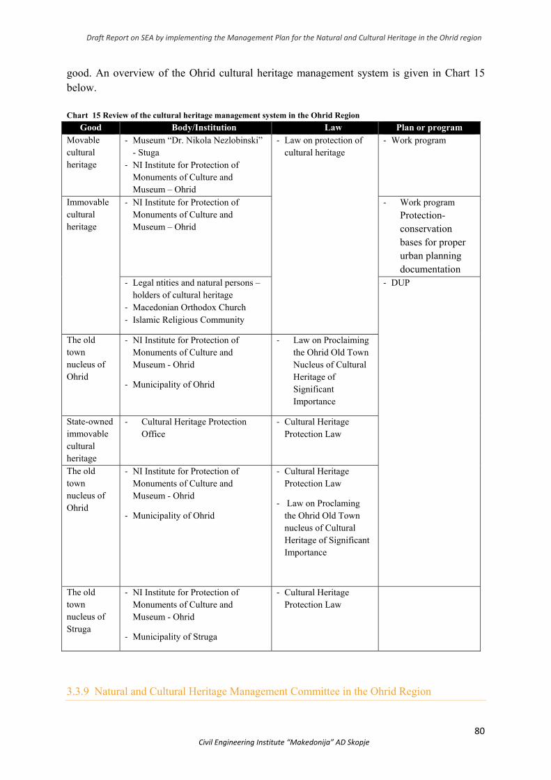
Draft Report on SEA by implementing the Management Plan for the Natural and Cultural Heritage in the Ohrid region
80 Civil Engineering Institute “Makedonija” AD Skopje
good. An overview of the Ohrid cultural heritage management system is given in Chart 15 below.
Chart 15 Review of the cultural heritage management system in the Ohrid Region
Good Body/Institution Law Plan or program Movable cultural heritage
‐ Museum “Dr. Nikola Nezlobinski” - Stuga
‐ NI Institute for Protection of Monuments of Culture and Museum – Ohrid
‐ Law on protection of cultural heritage
‐ Work program
Immovable cultural heritage
‐ NI Institute for Protection of Monuments of Culture and Museum – Ohrid
‐ Work program Protection-conservation bases for proper urban planning documentation
‐ Legal ntities and natural persons – holders of cultural heritage
‐ Macedonian Orthodox Church ‐ Islamic Religious Community
‐ DUP
The old town nucleus of Ohrid
‐ NI Institute for Protection of Monuments of Culture and Museum - Ohrid
‐ Municipality of Ohrid
‐ Law on Proclaiming the Ohrid Old Town Nucleus of Cultural Heritage of Significant Importance
State-owned immovable cultural heritage
‐ Cultural Heritage Protection Office
‐ Cultural Heritage Protection Law
The old town nucleus of Ohrid
‐ NI Institute for Protection of Monuments of Culture and Museum - Ohrid
‐ Municipality of Ohrid
‐ Cultural Heritage Protection Law
‐ Law on Proclaming the Ohrid Old Town nucleus of Cultural Heritage of Significant Importance
The old town nucleus of Struga
‐ NI Institute for Protection of Monuments of Culture and Museum - Ohrid
‐ Municipality of Struga
‐ Cultural Heritage Protection Law
3.3.9 Natural and Cultural Heritage Management Committee in the Ohrid Region

Draft Report on SEA by implementing the Management Plan for the Natural and Cultural Heritage in the Ohrid region
81 Civil Engineering Institute “Makedonija” AD Skopje
World natural and cultural heritage management in Ohrid Region is complex and includes a lot of stakeholders and disciplines. At the same time, coordinating the existing planning and management systems of the natural and cultiural heritage is needed. During the last years, the dialogue among different stakeholders was promoted in order for the most adequate methods of managing the natural and cultural heritage to be found.
Pursuant to the Law on Management of Natural and Cultural Heritage in the Ohrid Region, a Committee has been set up to take care of the transfer of outstanding universal values to future generations and is obliged to prevent the implementation of activities that may adversely affect these values. The Committee has 21 members.
The Draft Law on Management of Natural and Cultural Heritage in the Ohrid Region creates formal legal preconditions to prevent activities that adversely affect the outstanding universal values of the natural and cultural heritage in the Ohrid region, as well as to take measures for its active inclusion in community life as a factor of sustainable development. For this purpose, the Draft Law provides establishment of a Council for Monitoring and Coordination of Natural and Cultural Heritage Management in the Ohrid Region (hereinafter referred to as "the Council"), comprising a total of 14 appointed external experts and administrative officers - representatives of the Government of the Republic of North Macedonia, the Ministries of Environment and Physical Planning, Culture and Transport and Communications, the Municipalities of Ohrid, Struga and Debrca, the National Institute for the Protection of Monuments of Culture and Museum - Ohrid, Public Scientific Institution Hydrobiological Institute - Ohrid, Public Institution National Park Galicica and civil society organizations in the field of natural and cultural heritage.
The Council should take care and ensure that effective safeguards protect the natural and cultural values of the good by:
● Integrating and implementing planning at all levels; ● Intersectoral and interinstitutional cooperation; ● Involvement of civil society organizations in the planning and monitoring of the
implementation of the relevant strategic and planning documents;
4. ENVIRONMENTAL CHARACTRERISTICS IN AREAS WHICH COULD BE SIGNIFICANTLY AFFECTED AND A STATE WITH NO PLAN IMPLEMENTATION
As previously mentioned, the area of the Ohrid Region includes 9 sites with natural values identified as world heritage.
1. Holy Mother of God Kaliska - sublacustrine springs (Image 33);
Municipality of Struga Condition: potential urbanization, tourism, potential
pollution
Image 33. Holy Mother of God Kaliska
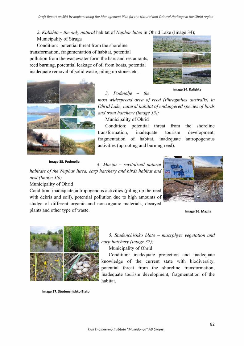
Draft Report on SEA by implementing the Management Plan for the Natural and Cultural Heritage in the Ohrid region
82 Civil Engineering Institute “Makedonija” AD Skopje
2. Kalishta – the only natural habitat of Nuphar lutea in Ohrid Lake (Image 34); Municipality of Struga Condition: potential threat from the shoreline
transformation, fragnmentation of habitat, potential pollution from the wastewater form the bars and restaurants, reed burning, potetntial leakage of oil from boats, potential inadequate removal of solid waste, piling up stones etc.
3. Podmolje – the
most widespread area of reed (Phragmites australis) in Ohrid Lake, natural habitat of endangered species of birds and trout hatchery (Image 35);
Municipality of Ohrid Condition: potential threat from the shoreline
transformation, inadequate tourism development, fragmentation of habitat, inadequate antropogenous activities (uprooting and burning reed).
4. Mazija – revitalized natural
habitatе of the Nuphar lutea, carp hatchery and birds habitat and nest (Image 36); Municipality of Ohrid Condition: inadequate antropogenous activities (piling up the reed with debris and soil), potential pollution due to high amounts of sludge of different organic and non-organic materials, decayed plants and other type of waste.
5. Studenchishko blato – macrphyte vegetation and carp hatchery (Image 37);
Municipality of Ohrid Condition: inadequate protection and inadequate
knowledge of the current state with biodiversity, potential threat from the shoreline transformation, inadequate tourism development, fragmentation of the habitat.
image 34. Kalishta
Image 35. Podmolje
Image 36. Mazija
Image 37. Studenchishko Blato
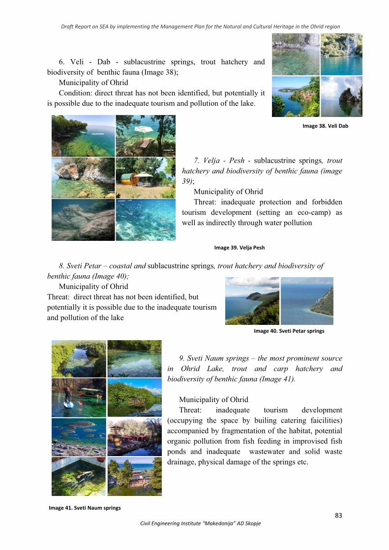
Draft Report on SEA by implementing the Management Plan for the Natural and Cultural Heritage in the Ohrid region
83 Civil Engineering Institute “Makedonija” AD Skopje
6. Veli - Dab - sublacustrine springs, trout hatchery and
biodiversity of benthic fauna (Image 38); Municipality of Ohrid Condition: direct threat has not been identified, but potentially it
is possible due to the inadequate tourism and pollution of the lake.
7. Velja - Pesh - sublacustrine springs, trout hatchery and biodiversity of benthic fauna (image 39);
Municipality of Ohrid Threat: inadequate protection and forbidden
tourism development (setting an eco-camp) as well as indirectly through water pollution
8. Sveti Petar – coastal and sublacustrine springs, trout hatchery and biodiversity of
benthic fauna (Image 40); Municipality of Ohrid
Threat: direct threat has not been identified, but potentially it is possible due to the inadequate tourism and pollution of the lake
9. Sveti Naum springs – the most prominent source in Ohrid Lake, trout and carp hatchery and biodiversity of benthic fauna (Image 41).
Municipality of Ohrid Threat: inadequate tourism development
(occupying the space by builing catering faicilities) accompanied by fragmentation of the habitat, potential organic pollution from fish feeding in improvised fish ponds and inadequate wastewater and solid waste drainage, physical damage of the springs etc.
Image 38. Veli Dab
Image 39. Velja Pesh
Image 40. Sveti Petar springs
Image 41. Sveti Naum springs
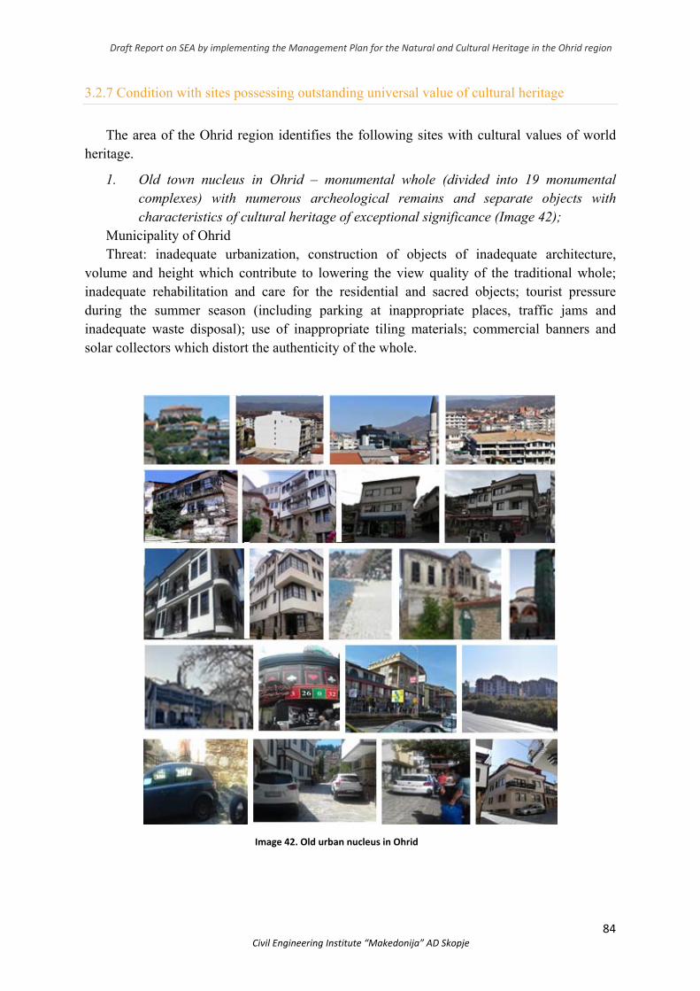
Draft Report on SEA by implementing the Management Plan for the Natural and Cultural Heritage in the Ohrid region
84 Civil Engineering Institute “Makedonija” AD Skopje
3.2.7 Condition with sites possessing outstanding universal value of cultural heritage
The area of the Ohrid region identifies the following sites with cultural values of world heritage.
1. Old town nucleus in Ohrid – monumental whole (divided into 19 monumental complexes) with numerous archeological remains and separate objects with characteristics of cultural heritage of exceptional significance (Image 42);
Municipality of Ohrid Threat: inadequate urbanization, construction of objects of inadequate architecture,
volume and height which contribute to lowering the view quality of the traditional whole; inadequate rehabilitation and care for the residential and sacred objects; tourist pressure during the summer season (including parking at inappropriate places, traffic jams and inadequate waste disposal); use of inappropriate tiling materials; commercial banners and solar collectors which distort the authenticity of the whole.
Image 42. Old urban nucleus in Ohrid
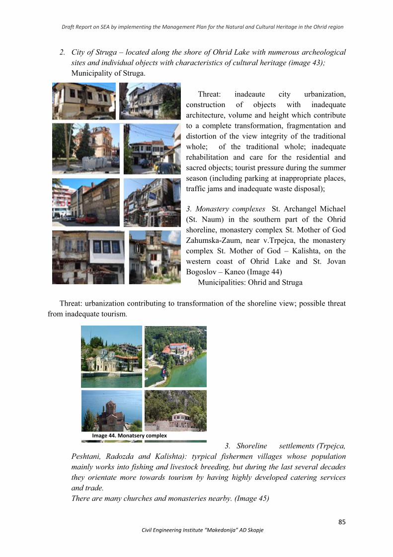
Draft Report on SEA by implementing the Management Plan for the Natural and Cultural Heritage in the Ohrid region
85 Civil Engineering Institute “Makedonija” AD Skopje
2. City of Struga – located along the shore of Ohrid Lake with numerous archeological sites and individual objects with characteristics of cultural heritage (image 43); Municipality of Struga.
Threat: inadeaute city urbanization,
construction of objects with inadequate architecture, volume and height which contribute to a complete transformation, fragmentation and distortion of the view integrity of the traditional whole; of the traditional whole; inadequate rehabilitation and care for the residential and sacred objects; tourist pressure during the summer season (including parking at inappropriate places, traffic jams and inadequate waste disposal);
3. Monastery complexes St. Archangel Michael (St. Naum) in the southern part of the Ohrid shoreline, monastery complex St. Mother of God Zahumska-Zaum, near v.Trpejca, the monastery complex St. Mother of God – Kalishta, on the western coast of Ohrid Lake and St. Jovan Bogoslov – Kaneo (Image 44)
Municipalities: Ohrid and Struga Threat: urbanization contributing to transformation of the shoreline view; possible threat
from inadequate tourism.
3. Shoreline settlements (Trpejca, Peshtani, Radozda and Kalishta): tyrpical fishermen villages whose population mainly works into fishing and livestock breeding, but during the last several decades they orientate more towards tourism by having highly developed catering services and trade. There are many churches and monasteries nearby. (Image 45)
Image 43. Град Струга со поединечни објекти
Image 44. Monatsery complex
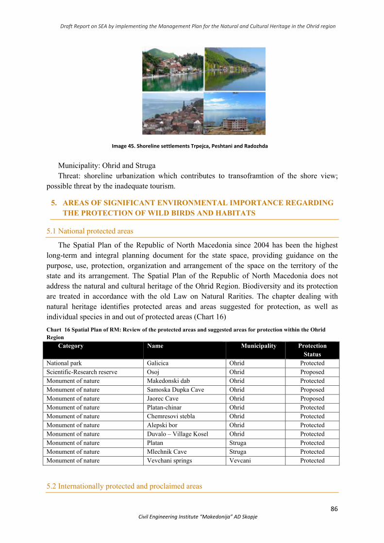
Draft Report on SEA by implementing the Management Plan for the Natural and Cultural Heritage in the Ohrid region
86 Civil Engineering Institute “Makedonija” AD Skopje
Municipality: Ohrid and Struga Threat: shoreline urbanization which contributes to transoframtion of the shore view;
possible threat by the inadequate tourism.
5. AREAS OF SIGNIFICANT ENVIRONMENTAL IMPORTANCE REGARDING THE PROTECTION OF WILD BIRDS AND HABITATS
5.1 National protected areas
The Spatial Plan of the Republic of North Macedonia since 2004 has been the highest long-term and integral planning document for the state space, providing guidance on the purpose, use, protection, organization and arrangement of the space on the territory of the state and its arrangement. The Spatial Plan of the Republic of North Macedonia does not address the natural and cultural heritage of the Ohrid Region. Biodiversity and its protection are treated in accordance with the old Law on Natural Rarities. The chapter dealing with natural heritage identifies protected areas and areas suggested for protection, as well as individual species in and out of protected areas (Chart 16)
Chart 16 Spatial Plan of RM: Review of the protected areas and suggested areas for protection within the Ohrid Region
Category Name Municipality Protection Status
National park Galicica Ohrid Protected Scientific-Research reserve Osoj Ohrid Proposed Monument of nature Makedonski dab Ohrid Protected Monument of nature Samoska Dupka Cave Ohrid Proposed Monument of nature Jaorec Cave Ohrid Proposed Monument of nature Platan-chinar Ohrid Protected Monument of nature Chemresovi stebla Ohrid Protected Monument of nature Alepski bor Ohrid Protected Monument of nature Duvalo – Village Kosel Ohrid Protected Monument of nature Platan Struga Protected Monument of nature Mlechnik Cave Struga Protected Monument of nature Vevchani springs Vevcani Protected
5.2 Internationally protected and proclaimed areas
Image 45. Shoreline settlements Trpejca, Peshtani and Radozhda
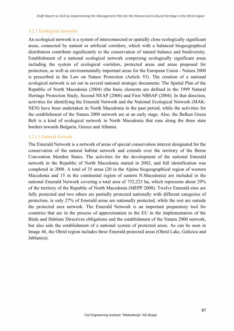
Draft Report on SEA by implementing the Management Plan for the Natural and Cultural Heritage in the Ohrid region
87 Civil Engineering Institute “Makedonija” AD Skopje
5.2.1 Ecological networks
An ecological network is a system of interconnected or spatially close ecologically significant areas, connected by natural or artificial corridors, which with a balanced biogeographical distribution contribute significantly to the conservation of natural balance and biodiversity. Establishment of a national ecological network comprising ecologically significant areas including the system of ecological corridors, protected areas and areas proposed for protection, as well as environmentally important areas for the European Union - Natura 2000 is prescribed in the Law on Nature Protection (Article 53). The creation of a national ecological network is set out in several national strategic documents: The Spatial Plan of the Republic of North Macedonia (2004) (the basic elements are defined in the 1999 Natural Heritage Protection Study, Second NEAP (2006) and First NBSAP (2004). In that direction, activities for identifying the Emerald Network and the National Ecological Network (MAK-NEN) have been undertaken in North Macedonia in the past period, while the activities for the establishment of the Natura 2000 network are at an early stage. Also, the Balkan Green Belt is a kind of ecological network in North Macedonia that runs along the three state borders towards Bulgaria, Greece and Albania.
5.2.1.1 Emerald Network
The Emerald Network is a network of areas of special conservation interest designated for the conservation of the natural habitat network and extends over the territory of the Berne Convention Member States. The activities for the development of the national Emerald network in the Republic of North Macedonia started in 2002, and full identification was completed in 2008. A total of 35 areas (20 in the Alpine biogeographical region of western Macedonia and 15 in the continental region of eastern N.Macedonia) are included in the national Emerald Network covering a total area of 752,223 ha, which represents about 29% of the territory of the Republic of North Macedonia (MEPP 2008). Twelve Emerald sites are fully protected and two others are partially protected nationally with different categories of protection, ie only 27% of Emerald areas are nationally protected, while the rest are outside the protected area network. The Emerald Network is an important preparatory tool for countries that are in the process of approximation to the EU in the implementation of the Birds and Habitats Directives obligations and the establishment of the Natura 2000 network, but also aids the establishment of a national system of protected areas. As can be seen in Image 46, the Ohrid region includes three Emerald protected areas (Ohrid Lake, Galicica and Jablanica).
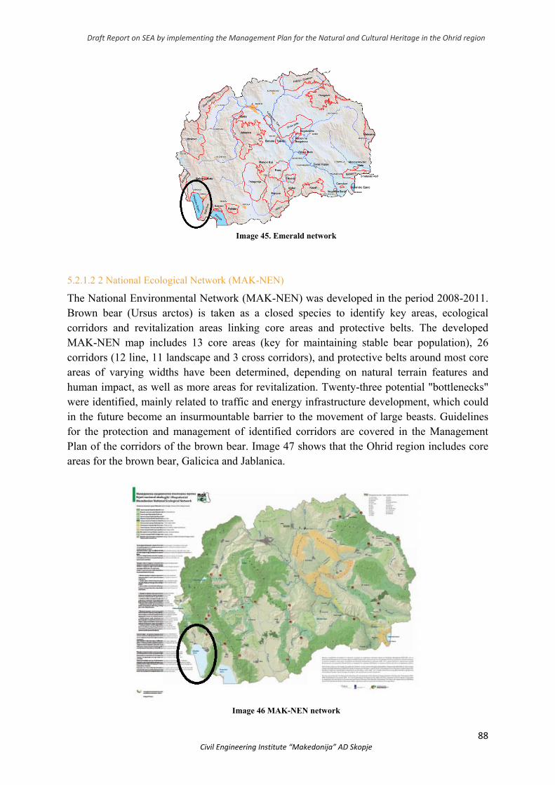
Draft Report on SEA by implementing the Management Plan for the Natural and Cultural Heritage in the Ohrid region
88 Civil Engineering Institute “Makedonija” AD Skopje
Image 45. Emerald network
5.2.1.2 2 National Ecological Network (MAK-NEN)
The National Environmental Network (MAK-NEN) was developed in the period 2008-2011. Brown bear (Ursus arctos) is taken as a closed species to identify key areas, ecological corridors and revitalization areas linking core areas and protective belts. The developed MAK-NEN map includes 13 core areas (key for maintaining stable bear population), 26 corridors (12 line, 11 landscape and 3 cross corridors), and protective belts around most core areas of varying widths have been determined, depending on natural terrain features and human impact, as well as more areas for revitalization. Twenty-three potential "bottlenecks" were identified, mainly related to traffic and energy infrastructure development, which could in the future become an insurmountable barrier to the movement of large beasts. Guidelines for the protection and management of identified corridors are covered in the Management Plan of the corridors of the brown bear. Image 47 shows that the Ohrid region includes core areas for the brown bear, Galicica and Jablanica.
Image 46 MAK-NEN network
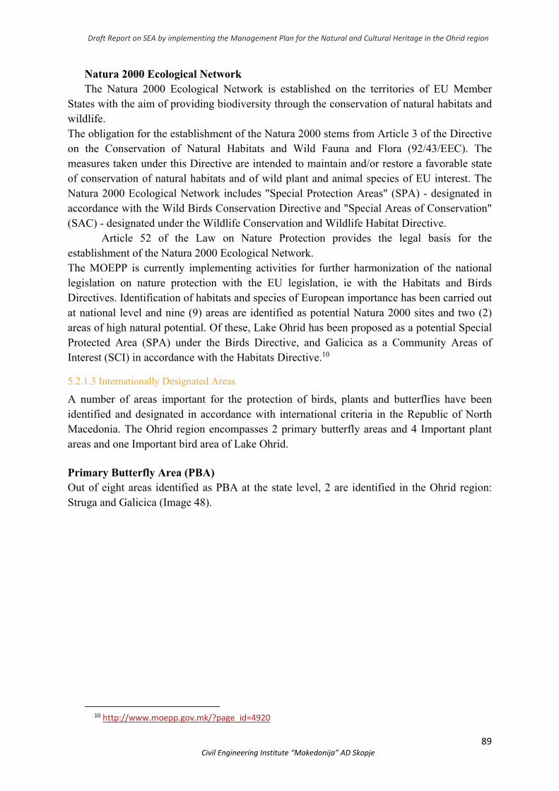
Draft Report on SEA by implementing the Management Plan for the Natural and Cultural Heritage in the Ohrid region
89 Civil Engineering Institute “Makedonija” AD Skopje
Natura 2000 Ecological Network The Natura 2000 Ecological Network is established on the territories of EU Member
States with the aim of providing biodiversity through the conservation of natural habitats and wildlife. The obligation for the establishment of the Natura 2000 stems from Article 3 of the Directive on the Conservation of Natural Habitats and Wild Fauna and Flora (92/43/EEC). The measures taken under this Directive are intended to maintain and/or restore a favorable state of conservation of natural habitats and of wild plant and animal species of EU interest. The Natura 2000 Ecological Network includes "Special Protection Areas" (SPA) - designated in accordance with the Wild Birds Conservation Directive and "Special Areas of Conservation" (SAC) - designated under the Wildlife Conservation and Wildlife Habitat Directive.
Article 52 of the Law on Nature Protection provides the legal basis for the establishment of the Natura 2000 Ecological Network. The MOEPP is currently implementing activities for further harmonization of the national legislation on nature protection with the EU legislation, ie with the Habitats and Birds Directives. Identification of habitats and species of European importance has been carried out at national level and nine (9) areas are identified as potential Natura 2000 sites and two (2) areas of high natural potential. Of these, Lake Ohrid has been proposed as a potential Special Protected Area (SPA) under the Birds Directive, and Galicica as a Community Areas of Interest (SCI) in accordance with the Habitats Directive.10
5.2.1.3 Internationally Designated Areas
A number of areas important for the protection of birds, plants and butterflies have been identified and designated in accordance with international criteria in the Republic of North Macedonia. The Ohrid region encompasses 2 primary butterfly areas and 4 Important plant areas and one Important bird area of Lake Ohrid.
Primary Butterfly Area (PBA) Out of eight areas identified as PBA at the state level, 2 are identified in the Ohrid region: Struga and Galicica (Image 48).
10 http://www.moepp.gov.mk/?page_id=4920
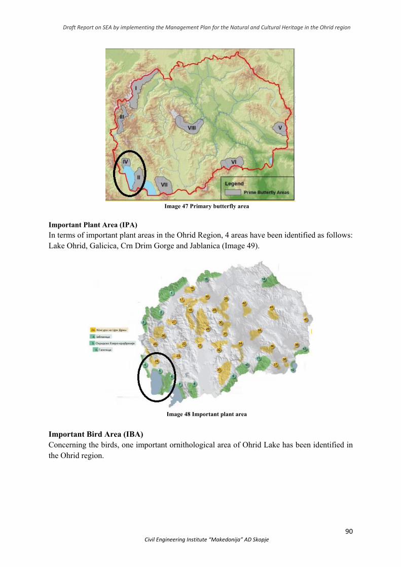
Draft Report on SEA by implementing the Management Plan for the Natural and Cultural Heritage in the Ohrid region
90 Civil Engineering Institute “Makedonija” AD Skopje
Image 47 Primary butterfly area
Important Plant Area (IPA)
In terms of important plant areas in the Ohrid Region, 4 areas have been identified as follows: Lake Ohrid, Galicica, Crn Drim Gorge and Jablanica (Image 49).
Image 48 Important plant area
Important Bird Area (IBA) Concerning the birds, one important ornithological area of Ohrid Lake has been identified in the Ohrid region.
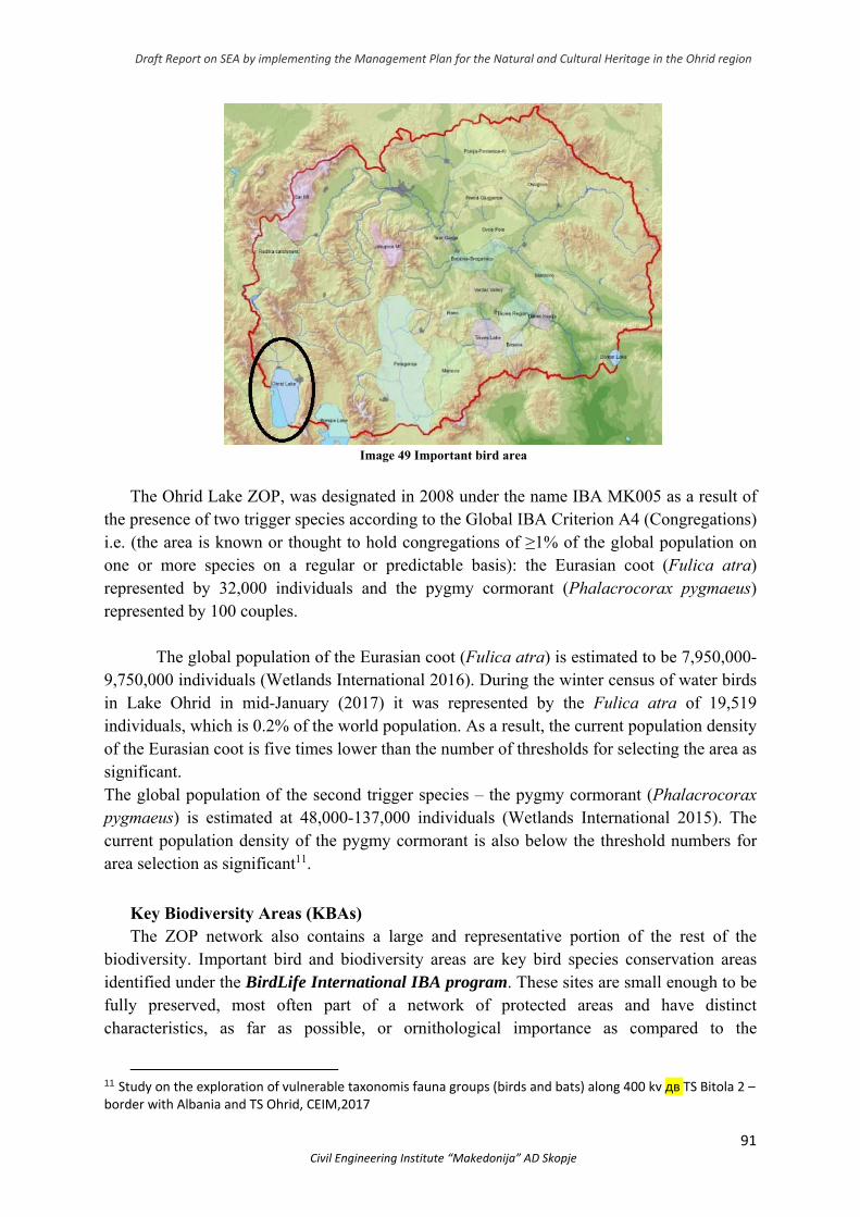
Draft Report on SEA by implementing the Management Plan for the Natural and Cultural Heritage in the Ohrid region
91 Civil Engineering Institute “Makedonija” AD Skopje
Image 49 Important bird area
The Ohrid Lake ZOP, was designated in 2008 under the name IBA MK005 as a result of the presence of two trigger species according to the Global IBA Criterion A4 (Congregations) i.e. (the area is known or thought to hold congregations of ≥1% of the global population on one or more species on a regular or predictable basis): the Eurasian coot (Fulica atra) represented by 32,000 individuals and the pygmy cormorant (Phalacrocorax pygmaeus) represented by 100 couples.
The global population of the Eurasian coot (Fulica atra) is estimated to be 7,950,000-9,750,000 individuals (Wetlands International 2016). During the winter census of water birds in Lake Ohrid in mid-January (2017) it was represented by the Fulica atra of 19,519 individuals, which is 0.2% of the world population. As a result, the current population density of the Eurasian coot is five times lower than the number of thresholds for selecting the area as significant. The global population of the second trigger species – the pygmy cormorant (Phalacrocorax pygmaeus) is estimated at 48,000-137,000 individuals (Wetlands International 2015). The current population density of the pygmy cormorant is also below the threshold numbers for area selection as significant11.
Key Biodiversity Areas (KBAs) The ZOP network also contains a large and representative portion of the rest of the
biodiversity. Important bird and biodiversity areas are key bird species conservation areas identified under the BirdLife International IBA program. These sites are small enough to be fully preserved, most often part of a network of protected areas and have distinct characteristics, as far as possible, or ornithological importance as compared to the
11 Study on the exploration of vulnerable taxonomis fauna groups (birds and bats) along 400 kv дв TS Bitola 2 – border with Albania and TS Ohrid, CEIM,2017
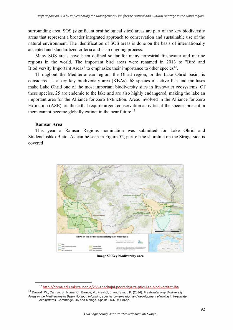
Draft Report on SEA by implementing the Management Plan for the Natural and Cultural Heritage in the Ohrid region
92 Civil Engineering Institute “Makedonija” AD Skopje
surrounding area. SOS (significant ornithological sites) areas are part of the key biodiversity areas that represent a broader integrated approach to conservation and sustainable use of the natural environment. The identification of SOS areas is done on the basis of internationally accepted and standardized criteria and is an ongoing process.
Many SOS areas have been defined so far for many terrestrial freshwater and marine regions in the world. The important bird areas were renamed in 2013 to "Bird and Biodiversity Important Areas" to emphasize their importance to other species12.
Throughout the Mediterranean region, the Ohrid region, or the Lake Ohrid basin, is considered as a key key biodiversity area (KBAs). 68 species of active fish and molluscs make Lake Ohrid one of the most important biodiversity sites in freshwater ecosystems. Of these species, 25 are endemic to the lake and are also highly endangered, making the lake an important area for the Alliance for Zero Extinction. Areas involved in the Alliance for Zero Extinction (AZE) are those that require urgent conservation activities if the species present in them cannot become globally extinct in the near future.13
Ramsar Area This year a Ramsar Regions nomination was submitted for Lake Ohrid and
Studenchishko Blato. As can be seen in Figure 52, part of the shoreline on the Struga side is covered
Image 50 Key biodiversity area
12 http://doma.edu.mk/zaucenje/255‐znachajni‐podrachja‐za‐ptici‐i‐za‐biodiverzitet‐iba
13 Darwall, W., Carrizo, S., Numa, C., Barrios, V., Freyhof, J. and Smith, K. (2014). Freshwater Key Biodiversity Areas in the Mediterranean Basin Hotspot: Informing species conservation and development planning in freshwater
ecosystems. Cambridge, UK and Malaga, Spain: IUCN. x + 86pp.
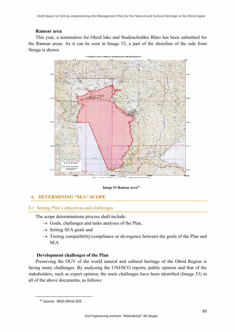
Draft Report on SEA by implementing the Management Plan for the Natural and Cultural Heritage in the Ohrid region
93 Civil Engineering Institute “Makedonija” AD Skopje
Ramsar area This year, a nomination for Ohrid lake and Studenchishko Blato has been submitted for
the Ramsar areas. As it can be seen in Image 52, a part of the shoreline of the side from Struga is shown.
Image 51 Ramsar area14
6. DETERMINING “SEA” SCOPE
6.1 Setting Plan’s objectives and challenges
The scope determinations process shall include:
Goals, challenges and tasks analyses of the Plan,
Setting SEA goals and
Testing compatibility/compliance or divergence between the goals of the Plan and SEA
Development challenges of the Plan Preserving the OUV of the world natural and cultural heritage of the Ohrid Region is
facing many challenges. By analysing the UNESCO reports, public opinion and that of the stakeholders, such as expert opinion, the main challenges have been identified (Image 53) in all of the above documents, as follows:
14 source: NGO Ohrid SOS
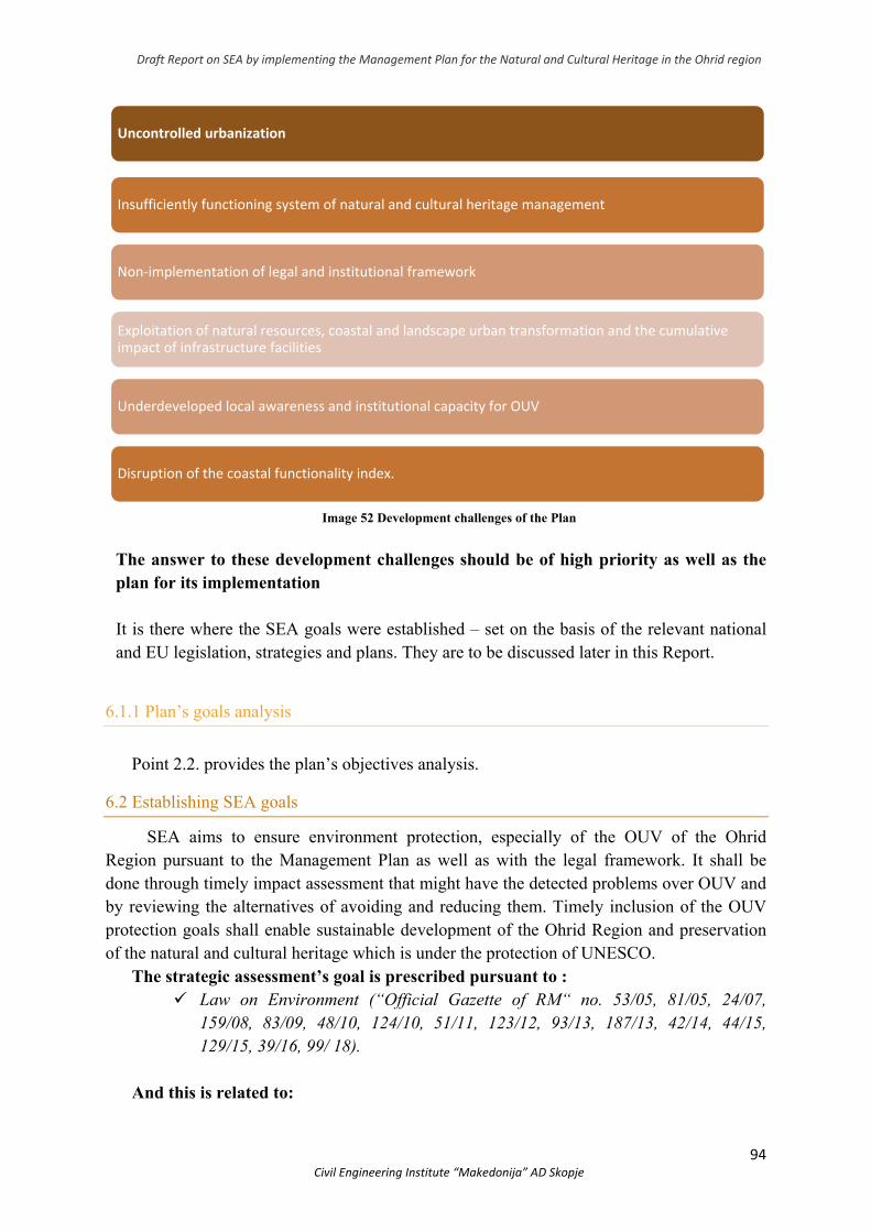
Draft Report on SEA by implementing the Management Plan for the Natural and Cultural Heritage in the Ohrid region
94 Civil Engineering Institute “Makedonija” AD Skopje
Image 52 Development challenges of the Plan
The answer to these development challenges should be of high priority as well as the plan for its implementation It is there where the SEA goals were established – set on the basis of the relevant national and EU legislation, strategies and plans. They are to be discussed later in this Report.
6.1.1 Plan’s goals analysis
Point 2.2. provides the plan’s objectives analysis.
6.2 Establishing SEA goals
SEA aims to ensure environment protection, especially of the OUV of the Ohrid Region pursuant to the Management Plan as well as with the legal framework. It shall be done through timely impact assessment that might have the detected problems over OUV and by reviewing the alternatives of avoiding and reducing them. Timely inclusion of the OUV protection goals shall enable sustainable development of the Ohrid Region and preservation of the natural and cultural heritage which is under the protection of UNESCO.
The strategic assessment’s goal is prescribed pursuant to : Law on Environment (“Official Gazette of RM“ no. 53/05, 81/05, 24/07,
159/08, 83/09, 48/10, 124/10, 51/11, 123/12, 93/13, 187/13, 42/14, 44/15, 129/15, 39/16, 99/ 18).
And this is related to:
Uncontrolled urbanization
Insufficiently functioning system of natural and cultural heritage management
Non‐implementation of legal and institutional framework
Exploitation of natural resources, coastal and landscape urban transformation and the cumulative impact of infrastructure facilities
Underdeveloped local awareness and institutional capacity for OUV
Disruption of the coastal functionality index.
Draft Report on SEA by implementing the Management Plan for the Natural and Cultural Heritage in the Ohrid region
95 Civil Engineering Institute “Makedonija” AD Skopje
Law on Management with the Natural and Cultiral Heirtage in the Ohrid (“Official Gazette of RM“ no. 75/2010),
Law on Cultural Heirtage Protection (“Official Gazette of RM“ no. 20/04, 71/04, 115/07, 18/11, 148/11, 23/13, 137/13, 164/13, 44/14, 199/14, 104/15, 154/15, 192/1539/16 and 11/18)
Law on Proclaiming the Old Town Nucleus of Ohrid as Cultural Heritage of Outstanding Value (“Official Gazette of RM“ no. 47/11 and154/15)
Law on Nature Protection (“Official Gazette of RM“ no. 67/2004, 14/2006 and 84/2007, 35/10, 47/11, 148/11, 59/12, 13/13, 163/13, 41/14146/15, 39/16 , 63/16 and 113/18)
Law on Environment (“Official Gazette of RM“ no. 53/05, 81/05, 24/07, 159/08, 83/09, 48/10, 124/10, 51/11, 123/12, 93/13, 187/13, 42/14, 44/15, 129/15, 39/16, 99/ 18)
Law on waters (“Official Gazette of RM“ no. 87/08, 06/09, 161/09, 83/10, 51/11, 44/12, 23/13, 163/13, 180/14, 146/15 and 52/16)
Law on Inland Waterways (“Official Gazette of RM“ no.55/07, 26/09, 22/10, 23/11, 53/11, 155/12 and 15/13, 137/13, 163/13, 42/14, 166/14, 146/15, 193/15 and 31/16)
Law on Protection of Ohrid, Prespa and Dojran Lake (“Official Gazette of RM“ no. 45/77, 8/80, 51/88, 10/90 and 62/93). Ohrid Lake was proclaimed as a protected area in the category of Monuments of nature
Law on Proclaiming Forest Areas in Mountin Galicica as a National Park (“Official Gazette of PRM“ no.31/58 and 16/65) and Law on Proclaiming Part of Mt. Galicica a National Park (“Official Gazette of RM“ no.171/10)
Law on Forests (“Official Gazette of RM“ no.64/09, 24/11, 53/11, 25/13, 79/13, 147/14, 160/14, 33/15, 44/15, 147/15 and 39/16)
Law on Pastures (“Official Gazette of RM“ no.3/98, 101/00, 89/08, 105/09, 42/10, 116/10, 164/13, 193/15 and 215/15)
Law on Spatial and Urban Planning (“Official Gazette of RM“ no.199/14, 44/15, 193/15, 31/16, 163/16, 64/18 and 168/18)
Law on Construction Land (“Official Gazette of RM“ no.15/15, 44/15, 98/15, 193/15, 226/15, 30/16 and 31/16)
Law on Construction (“Official Gazette of RM“ no.130/09, 124/10, 18/11, 36/11, 54/11, 59/11, 13/12, 39/12, 144/12, 25/13, 70/13, 79/13, 137/13, 163/13, 27/14, 28/14, 42/14, 115/14, 187/14, 44/15, 129/15, 217/15, 226/15, 30/16 и 31/16, 39/16, 71/16, 132/16,35/18 64/18 and 168/18)
Law on the Ratification of the Agreement between the Government of Republic of North Macedonia and the Council of Ministers of Republic of Albania for Protection and Sustainable Development of Ohrid Lake and its Basin (“Official Gazette of RM“ no.46/05 - 99 session, 10.06.2005)
Draft Report on SEA by implementing the Management Plan for the Natural and Cultural Heritage in the Ohrid region
96 Civil Engineering Institute “Makedonija” AD Skopje
SEA focuses on impacts that cannot be easily resolved at the project level (as in the case of cumulative impacts), i.e. problems that need to be addressed at strategic level. Key issues to be assessed were identified, drawn up on the basis of UNESCO recommendations, issues raised by the institutions concerned, and issues of concern to the public and non-governmental sector, as well as the expert findings of the SEA study team
Given the fact that it is a complex system encompassing nature conservation and cultural heritage, it interacts with many other planning documents, programs and strategies. Therefore the potential existence of direct and indirect links between the plan in question and other planning documents at local, regional, national and/or international level, their compatibility and compliance within the strategic environmental assessment procedure needs to be analyzed. This type of analysis should determine whether there is a potential conflict of compliance between the objectives of the various planning documents, and if this appears to be the case, it is necessary to define compatibility measures. For the purposes of analyzing the links and compatibility between the Ohrid Region Heritage Management Plan 2019-2028 and other planning documents, several planning documents at local, regional and national level from the following key areas have been analyzed in the context of the SEA procedure in the plan: a) Management of protected areas; b) Environmental protection; c) Economic development; d) Sustainable development, e) Relevant areas - tourism, energy, transport, social policy.
The synchronization of the considered planning document with other existing plans, programs and strategies will prospectively enable its realization, and in addition to achieving the direct objectives of the plan, more or less contribute to the realization of the objectives of the other plans. The continued application of such an approach, within the SEA, provides a systematic solution for achieving a high degree of complementarity with the objectives of individual planning documents and optimizing efficiency in their achievement, regardless of their hierarchical or other type of relationship.
The planning document is prepared in accordance with all the adopted domestic legislation, EU legislation, as well as international documents ratified in the Republic of North Macedonia.
National plans, programs and strategies: 1. Spatial Plan of the republic of North Macedonia (2004-2020) 2. Spatial Plan of the Ohrid-Prespa Region (2005-2021) 3. Management Plan for the National Park Galicica (2011-2010) (Draft-version) 4. National Strategy on Culture Development (2018-2022); 5. Draft National Strategy on the Bio-diversity of the Action Plan (2015); 6. National Strategy on Nature Protection (2017-2027). 7. Regional Development Startegy of Republic of North Macedonia (2009-2019); 8. Third National Plan of Republic of North Macedonia to the UN Framework Convention
on Climate Changes (2014) 9. National Strategy on Waste Management (2008-2020); 10. National Strategy on Sustainable Development (2009-2030); 11. National Plan on Ambient Air Protection (2013-2019)
Draft Report on SEA by implementing the Management Plan for the Natural and Cultural Heritage in the Ohrid region
97 Civil Engineering Institute “Makedonija” AD Skopje
12. National Strategy on Agricultural and Rural Development (2014-2020); 13. National Strategy on Waters (2011-2041); 14. National Transport Strategy (2007-2017) 15. National Strategy on Tourism Development (2009-2013); 16. Strategy on the Environment and Climate Changes (2014-2020) 17. Development Program for the Southwest Planning Region (2015 – 2019); 18. Physical Landscaping of Ohrid Region at a Municipal Level
6.3 Testing of offshore part regarding the environment’s objectives
As mentioned, SEA objectives arise from the current laws, strategies and plans as well as from OUV detected issues of the Ohrid Region.
SEA process has to ensure that SEA objectives are taken into account, as follows: - The comparison made between the Plan and SEA’s objectives is to identify potential
issues. - Plan’s objectives can be redesigned so as to escape and/or decrease these issues. - There should be adequate mitigation measures identified for the conflict areas.
6.3.1 Comparison between the Plan and SEA’s objectives
The chart given below shows the Plan’s objectives and their relationship regarding SEA’s objectives. Numbers shown next to SEA are in fact the National plans, programs and strategies arising and are given on page 76.
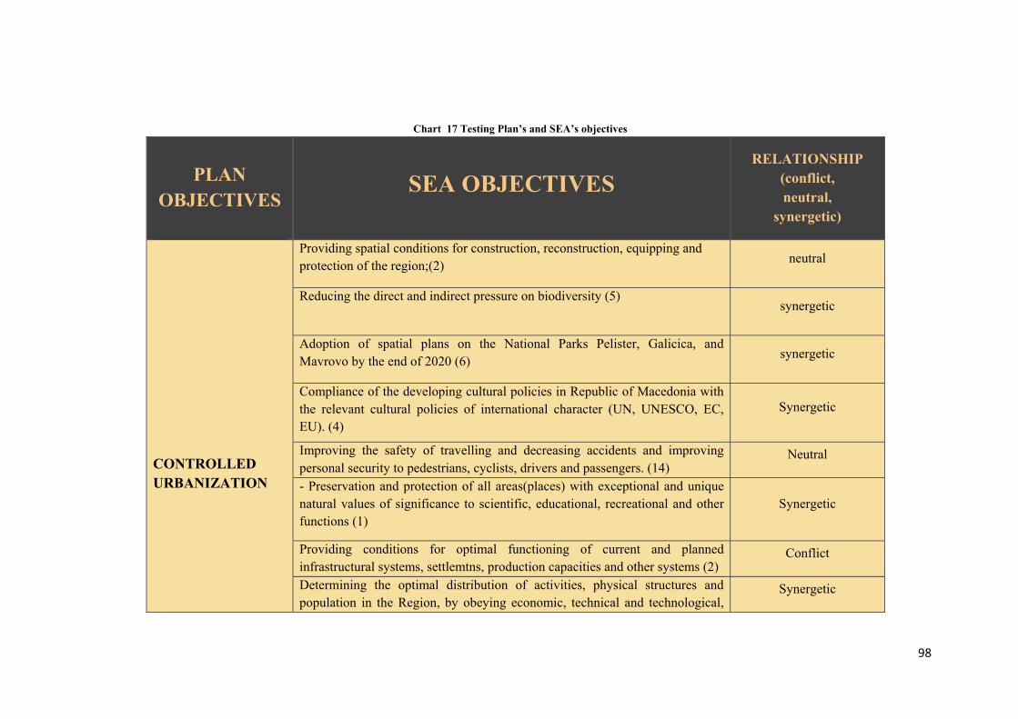
98
Chart 17 Testing Plan’s and SEA’s objectives
PLAN
OBJECTIVES
SEA OBJECTIVES
RELATIONSHIP (conflict, neutral,
synergetic)
CONTROLLED URBANIZATION
Providing spatial conditions for construction, reconstruction, equipping and protection of the region;(2)
neutral
Reducing the direct and indirect pressure on biodiversity (5)
synergetic
Adoption of spatial plans on the National Parks Pelister, Galicica, and Mavrovo by the end of 2020 (6)
synergetic
Compliance of the developing cultural policies in Republic of Macedonia with the relevant cultural policies of international character (UN, UNESCO, EC, EU). (4)
Synergetic
Improving the safety of travelling and decreasing accidents and improving personal security to pedestrians, cyclists, drivers and passengers. (14)
Neutral
- Preservation and protection of all areas(places) with exceptional and unique natural values of significance to scientific, educational, recreational and other functions (1)
Synergetic
Providing conditions for optimal functioning of current and planned infrastructural systems, settlemtns, production capacities and other systems (2)
Conflict
Determining the optimal distribution of activities, physical structures and population in the Region, by obeying economic, technical and technological,
Synergetic
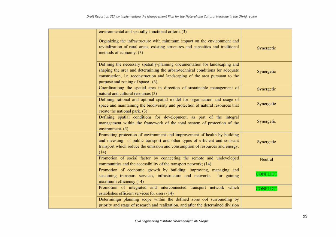
Draft Report on SEA by implementing the Management Plan for the Natural and Cultural Heritage in the Ohrid region
99 Civil Engineering Institute “Makedonija” AD Skopje
environmental and spatially-functional criteria (3)
Organizing the infrastructure with minimum impact on the envieonment and revitalization of rural areas, existing structures and capacities and traditional methods of economy. (3)
Synergetic
Defining the necessary spatially-planning documentation for landscaping and shaping the area and determining the urban-technical conditions for adequate construction, i.e. reconstruction and landscaping of the area pursuant to the purpose and zoning of space. (3)
Synergetic
Coordinationg the spatial area in direction of sustainable management of natural and cultural resources (3)
Synergetic
Defining rational and optimal spatial model for organization and usage of space and maintaining the biodiversity and protection of natural resources that create the national park. (3)
Synergetic
Defining spatial conditions for development, as part of the integral management within the framework of the total system of protection of the environment. (3)
Synergetic
Promoting protection of environment and improvement of health by building and investing in public transport and other types of efficient and constant transport which reduce the emission and consumption of resources and energy. (14)
Synergetic
Promotion of social factor by connecting the remote and undeveloped communities and the accessibility of the transport network; (14)
Neutral
Promotion of economic growth by building, improving, managing and sustaining transport services, infrastructure and networks for gaining maximum efficiency (14)
CONFLICT
Promotion of integrated and interconnected transport network which establishes efficient services for users (14)
CONFLICT
Determinign planning scope within the defined zone oof surrounding by priority and stage of research and realization, and after the determined division
Draft Report on SEA by implementing the Management Plan for the Natural and Cultural Heritage in the Ohrid region
100 Civil Engineering Institute “Makedonija” AD Skopje
of urban blocks.
Determining the parameters on the size of planned areas for certain purposes, based on norms for planning of facilities (18)
Synergetic
Rational usage of space, maximum adaptation of the infrastructure and facilities with the terrain; shaping the recognizable ambient whole; following and protecting the law on human’s privacy; following and upgrading landscape values; shaping cultural landscape; including accompanying content to the basic intended use; obeying the legal regulations, standards and norms in planning; predicting measures on protection and rescue. (18)
Synergetic
Conversion of UЗ17 - UB 17.1 from (proposal) strictly protected zone СЗЗ-Studenchishko Blato into А0- housing with special regime (15)
CONFLICT
Zoning changes in National Park Galicica so as to enable realization of development proejcs (18)
CONFLICT
Revitalization of infrastructure (18) Synergetic
Paying attention to capacities of the middle or surrounding for the use of space regarding the number of torusits, activities and objects that could be simultaneously present, and the space should not lose its existing attraction (18)
Synergetic
Development of tourist development zones КО ljubanista, КО Ohrid 4, КО Kalishta, КО Struga, КО Stenjе, КО Otesevo; - auto camps: „Ljubanista", „Gradiste", „Elesec", „Andon Dukov", „Аs“, „Livadistе" and „Treska";
CONFLICT
Improving the legislation frame pursuant to the EU legislation and relevant ratified international agreements for nature protection and providing adequate institutional frame through strengthening the administrative capacities (6)
Synergetic
Strengthening the database, analytic and institutional capacity of key national institutions for integration of priorities on climate changes in national strategies for development and relevant sectoral programs by providing financial and technical support. (8)
Synergetic
Draft Report on SEA by implementing the Management Plan for the Natural and Cultural Heritage in the Ohrid region
101 Civil Engineering Institute “Makedonija” AD Skopje
STRENGTHENING AUTHORITIES MANAGEMENT CAPACITIES
By 2022 the policy on nature protection would have been included within the strategies, plans and programs in other sectors. (6)
Synergetic
Initiating collaboration on a trilateral level in all segmens of development and setting foundations of the sustainable economic and social development and integral protection of the area from all trhee sides (2)
Synergetic
Establishing favourable financial and material ambient for long-term cultural development by commiting to continuous increase of the budgetary funds planned for program activities in culture. (4)
Synergetic
Stimulating creativity and artistic potential in all citizens of Republic of Macedonia regardless of theethnic, religious, ideological, political, social affiliation or sex and age. (4)
Neutral
Inclusion of Republic of North Macedonia in the global efforts of mitigating the climate changes and implementing the responsibilities undertaken from the membership in the UN Framework Convention on Climate Chnages and Kyoto Protocol. (8)
Neutral
Establishing national fund for testing adaptation measures and introduction of types- drought resistant. (8)
Neutral
Foring national centre of drought (8) Neutral
Developing criteria and identifying the methods of land use and agricultural zones etc. (8)
Neutral
Providing continuous and increased funding for nature protection from the budgetary funds centrally and locally, from investments and other funding sources, through establishing adequate sustainable and efficient funding models of protection and sustainable use of nature. (6)
Neutral
Introducing stable financial resources and adequate economic mechanisms of securing full coverage of the expenses for maintaining the integrated system of waste management; (9)
neutral
Draft Report on SEA by implementing the Management Plan for the Natural and Cultural Heritage in the Ohrid region
102 Civil Engineering Institute “Makedonija” AD Skopje
Establishing system of gathering data/information on sources, nature, amount and fate of waste flow, as well as of capactities on renewal on the materials/enegy and waste disposal and providing necessary access to it for the public; (9)
Neutral
-Establishing technical and modern waste management system; (9) Neutral
-Applying efficient and cost-effective techniques of managing special flows of waste; (9)
Neutral
Introducing landfills for dangerous and non-dangerous waste and other capacities for waste disposal pursuant to the modern standards; (9)
Neutral
-Gradual closure and/or sanation of existing communcal waste dumps and/or industrial environmental hotspots. (9)
Synergetic
Creating business environment and room for new employments (18) Synergetic
NATURAL HERITAGE PRESERVATION
-Air quality control and reduction of threats to human health and eco-systems functioning (11)
Neutral
Preserving and protecting all areas (places) with outstanding and unique natural values significant for scientific, cultural and educational as well as recreational and other activities (1)
Synergetic
Providing integral protection of natural spatial whole of National Parks and monuments of nature (Jablanica, Ohrid Lake, Galicica, Prespa Lake, Pelister). (2)
Synergetic
Securing protection of nature in North Macedonia, based on “Natura 2000” network, through strong implementation of the Biodoversity Strategy and Action Plan (10)
Synergetic
Promoting new network of Environmental Monitoring (10) Synergetic
Preserving good water state, preventing water pollution, preventing hydro-morphological changes and rehabilitation of the watr status where it has been disrupted. (13)
Synergetic
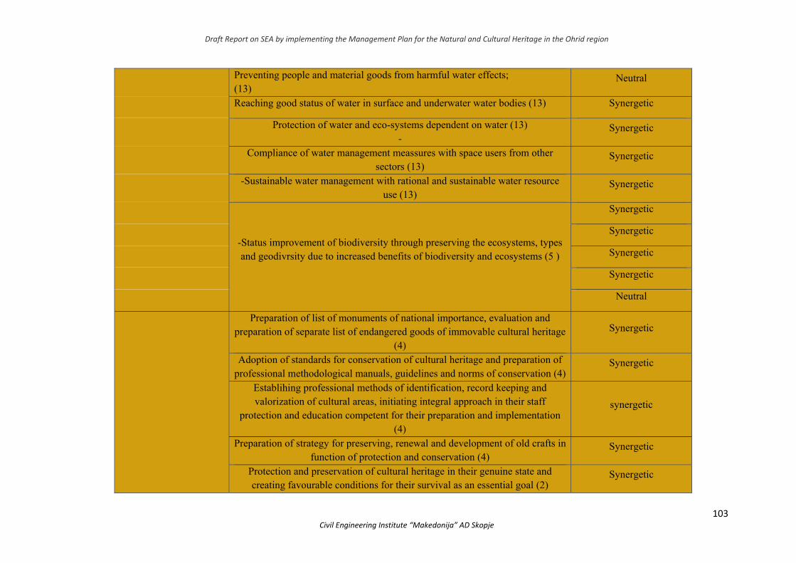
Draft Report on SEA by implementing the Management Plan for the Natural and Cultural Heritage in the Ohrid region
103 Civil Engineering Institute “Makedonija” AD Skopje
Preventing people and material goods from harmful water effects; (13)
Neutral
Reaching good status of water in surface and underwater water bodies (13) Synergetic
Protection of water and eco-systems dependent on water (13) -
Synergetic
Compliance of water management meassures with space users from other sectors (13)
Synergetic
-Sustainable water management with rational and sustainable water resource use (13)
Synergetic
-Status improvement of biodiversity through preserving the ecosystems, types and geodivrsity due to increased benefits of biodiversity and ecosystems (5 )
Synergetic
Synergetic
Synergetic
Synergetic
Neutral
Preparation of list of monuments of national importance, evaluation and preparation of separate list of endangered goods of immovable cultural heritage
(4)
Synergetic
Adoption of standards for conservation of cultural heritage and preparation of professional methodological manuals, guidelines and norms of conservation (4)
Synergetic
Establihing professional methods of identification, record keeping and valorization of cultural areas, initiating integral approach in their staff
protection and education competent for their preparation and implementation (4)
synergetic
Preparation of strategy for preserving, renewal and development of old crafts in function of protection and conservation (4)
Synergetic
Protection and preservation of cultural heritage in their genuine state and creating favourable conditions for their survival as an essential goal (2)
Synergetic
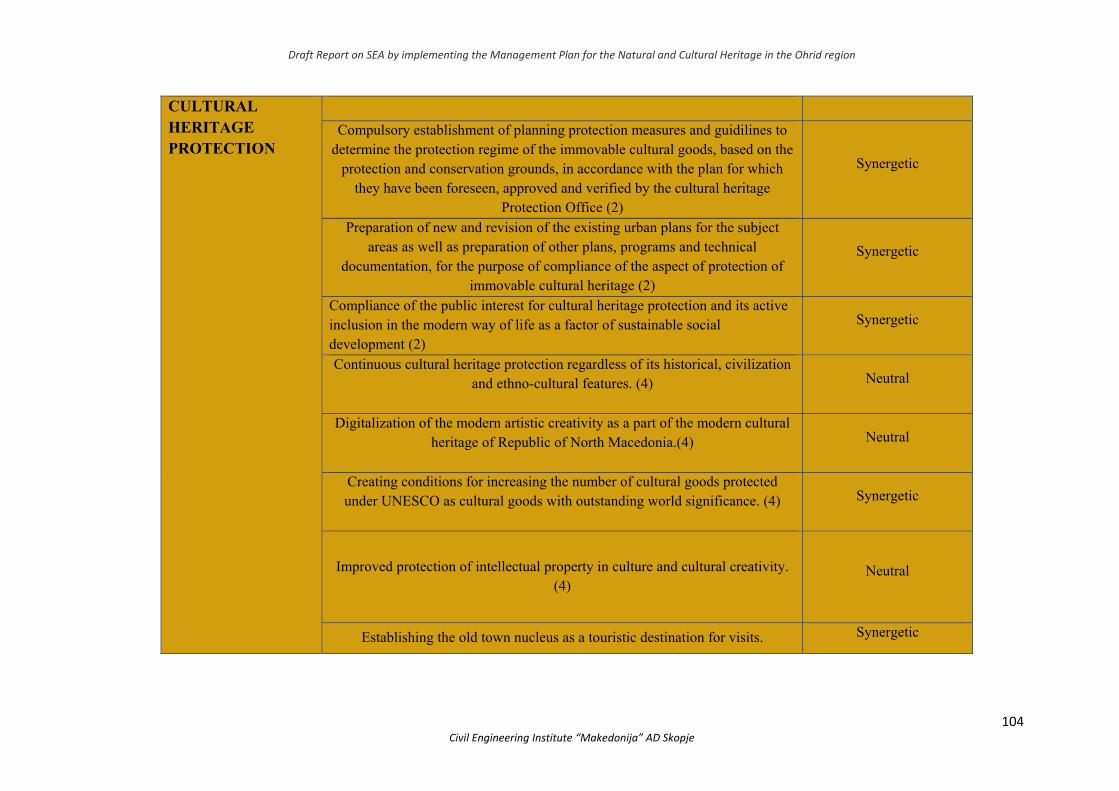
Draft Report on SEA by implementing the Management Plan for the Natural and Cultural Heritage in the Ohrid region
104 Civil Engineering Institute “Makedonija” AD Skopje
CULTURAL HERITAGE PROTECTION
Compulsory establishment of planning protection measures and guidilines to determine the protection regime of the immovable cultural goods, based on the
protection and conservation grounds, in accordance with the plan for which they have been foreseen, approved and verified by the cultural heritage
Protection Office (2)
Synergetic
Preparation of new and revision of the existing urban plans for the subject areas as well as preparation of other plans, programs and technical
documentation, for the purpose of compliance of the aspect of protection of immovable cultural heritage (2)
Synergetic
Compliance of the public interest for cultural heritage protection and its active inclusion in the modern way of life as a factor of sustainable social development (2)
Synergetic
Continuous cultural heritage protection regardless of its historical, civilization and ethno-cultural features. (4)
Neutral
Digitalization of the modern artistic creativity as a part of the modern cultural heritage of Republic of North Macedonia.(4)
Neutral
Creating conditions for increasing the number of cultural goods protected under UNESCO as cultural goods with outstanding world significance. (4)
Synergetic
Improved protection of intellectual property in culture and cultural creativity. (4)
Neutral
Establishing the old town nucleus as a touristic destination for visits. Synergetic
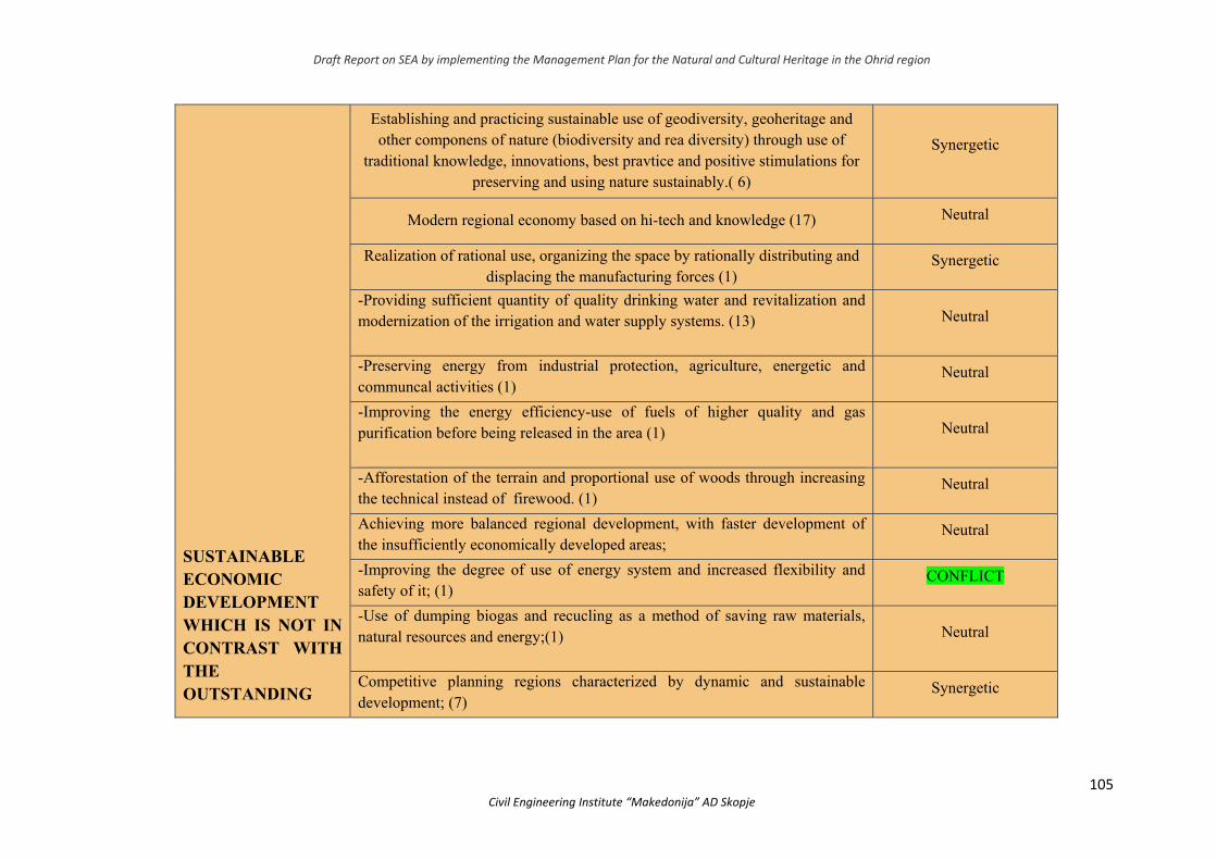
Draft Report on SEA by implementing the Management Plan for the Natural and Cultural Heritage in the Ohrid region
105 Civil Engineering Institute “Makedonija” AD Skopje
SUSTAINABLE ECONOMIC DEVELOPMENT WHICH IS NOT IN CONTRAST WITH THE OUTSTANDING
Establishing and practicing sustainable use of geodiversity, geoheritage and other componens of nature (biodiversity and rea diversity) through use of
traditional knowledge, innovations, best pravtice and positive stimulations for preserving and using nature sustainably.( 6)
Synergetic
Modern regional economy based on hi-tech and knowledge (17) Neutral
Realization of rational use, organizing the space by rationally distributing and displacing the manufacturing forces (1)
Synergetic
-Providing sufficient quantity of quality drinking water and revitalization and modernization of the irrigation and water supply systems. (13)
Neutral
-Preserving energy from industrial protection, agriculture, energetic and communcal activities (1)
Neutral
-Improving the energy efficiency-use of fuels of higher quality and gas purification before being released in the area (1)
Neutral
-Afforestation of the terrain and proportional use of woods through increasing the technical instead of firewood. (1)
Neutral
Achieving more balanced regional development, with faster development of the insufficiently economically developed areas;
Neutral
-Improving the degree of use of energy system and increased flexibility and safety of it; (1)
CОNFLICT
-Use of dumping biogas and recucling as a method of saving raw materials, natural resources and energy;(1)
Neutral
Competitive planning regions characterized by dynamic and sustainable development; (7)
Synergetic
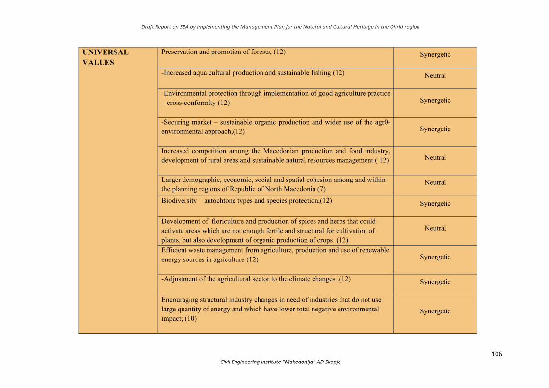
Draft Report on SEA by implementing the Management Plan for the Natural and Cultural Heritage in the Ohrid region
106 Civil Engineering Institute “Makedonija” AD Skopje
UNIVERSAL VALUES
Preservation and promotion of forests, (12)
Synergetic
-Increased aqua cultural production and sustainable fishing (12)
Neutral
-Environmental protection through implementation of good agriculture practice – cross-conformity (12)
Synergetic
-Securing market – sustainable organic production and wider use of the agr0-environmental approach,(12)
Synergetic
Increased competition among the Macedonian production and food industry, development of rural areas and sustainable natural resources management.( 12)
Neutral
Larger demographic, economic, social and spatial cohesion among and within the planning regions of Republic of North Macedonia (7)
Neutral
Biodiversity – autochtone types and species protection,(12) Synergetic
Development of floriculture and production of spices and herbs that could activate areas which are not enough fertile and structural for cultivation of plants, but also development of organic production of crops. (12)
Neutral
Efficient waste management from agriculture, production and use of renewable energy sources in agriculture (12)
Synergetic
-Adjustment of the agricultural sector to the climate changes .(12) Synergetic
Encouraging structural industry changes in need of industries that do not use large quantity of energy and which have lower total negative environmental impact; (10)
Synergetic

Draft Report on SEA by implementing the Management Plan for the Natural and Cultural Heritage in the Ohrid region
107 Civil Engineering Institute “Makedonija” AD Skopje
-Using the mechanism of clean development according to the Kyoto Protocol as additional tool in the projects (10)
Synergetic
Determining techniques and procedures for cultivation, use of fertilizers and reclamation of soil for key cultures in the regions affected by climate changes (8)
Neutral
Introducing different practices of ploughing for promoting sustainable agricultural practices (8)
Neutral
Developing irrigation and water supply techniques (8)
Neutral
Determining techniques and procedures for cultivation, use of fertilizers and reclamation of soil for key cultures in the regions affected by climate changes (8)
Neutral
-Creating image of recognizable European tourist destination, based on cultural and natural heritage and famous for high qialuty products incorporated within a common name – a Macedonian tourist product. (15)
Synergetic
Products and services development (Recognizable products, categorization of accommodation capacities, wine tourism, rural tourism, culture and crafts, baths), adequate access and infrastructure (road infrastructure, air access); (15)
Synergetic
-Strategy implementation plan on the tourism development (15) Synergetic
Promotion of environmental protection and improvement of healthcare by investing in public transport and other types of efficient and constant transport that reduces the emission and consumption of resources and energy;(15)
Synergetic
Environmental and cultural heritage management and protection. Tourism development through public and private partnership, as well as improved touristic infrastructure and torustic offer(15)
Synergetic
Increasing employment and constant improvement of material, cultural, social Neutral
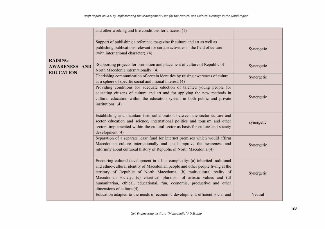
Draft Report on SEA by implementing the Management Plan for the Natural and Cultural Heritage in the Ohrid region
108 Civil Engineering Institute “Makedonija” AD Skopje
RAISING AWARENESS AND EDUCATION
and other working and life conditions for citizens; (1) Support of publishing a reference magazine fr culture and art as well as publishing publications relevant for certain activities in the field of culture (with international character). (4)
Synergetic
-Supporting projects for promotion and placement of culture of Republic of North Macedonia internationally (4)
Synergetic
Cherishing communication of certain identities by raising awareness of culure as a sphere of specific social and ntional interest. (4)
Synergetic
Providing conditions for adequate eduction of talented young people for educating citizens of culture and art and for applying the new methods in cultural education within the education system in both public and private institutions. (4)
Synergetic
Establishing and maintain firm collaboration between the sector culture and sector education and science, international politics and tourism and other sectors implemented within the cultural sector as basis for culture and society development (4)
synergetic
Separation of a separate lease fund for internet premises which would affirm Macedonian culture internationally and shall improve the awareness and informity about cultureal history of Republic of North Macedonia (4)
Synergetic
Encouring cultural development in all its complexity: (а) inherited traditional and ethno-cultural identity of Macedonian people and other people living at the territory of Republic of North Macedonia, (b) multicultural reality of Macedonian society, (c) estaetical pluralism of artistic values and (d) humanitarian, ethical, educational, fun, economic, productive and other dimensions of culture (4)
Synergetic
Education adapted to the needs of economic development, efficient social and Neutral
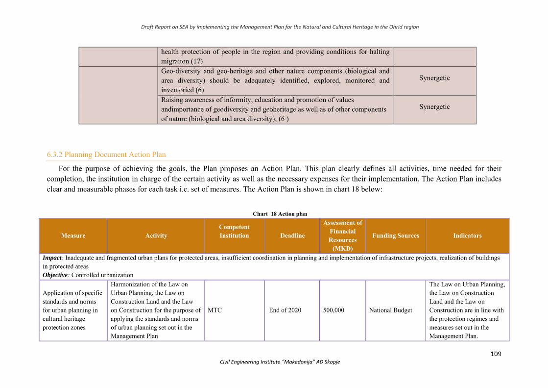
Draft Report on SEA by implementing the Management Plan for the Natural and Cultural Heritage in the Ohrid region
109 Civil Engineering Institute “Makedonija” AD Skopje
health protection of people in the region and providing conditions for halting migraiton (17)
Geo-diversity and geo-heritage and other nature components (biological and area diversity) should be adequately identified, explored, monitored and inventoried (6)
Synergetic
Raising awareness of informity, education and promotion of values andimportance of geodiversity and geoheritage as well as of other components of nature (biological and area diversity); (6 )
Synergetic
6.3.2 Planning Document Action Plan
For the purpose of achieving the goals, the Plan proposes an Action Plan. This plan clearly defines all activities, time needed for their completion, the institution in charge of the certain activity as well as the necessary expenses for their implementation. The Action Plan includes clear and measurable phases for each task i.e. set of measures. The Action Plan is shown in chart 18 below:
Chart 18 Action plan
Measure Activity Competent Institution
Deadline
Assessment of Financial Resources
(MKD)
Funding Sources Indicators
Impact: Inadequate and fragmented urban plans for protected areas, insufficient coordination in planning and implementation of infrastructure projects, realization of buildings in protected areas Objective: Controlled urbanization
Application of specific standards and norms for urban planning in cultural heritage protection zones
Harmonization of the Law on Urban Planning, the Law on Construction Land and the Law on Construction for the purpose of applying the standards and norms of urban planning set out in the Management Plan
MTC End of 2020 500,000 National Budget
The Law on Urban Planning, the Law on Construction Land and the Law on Construction are in line with the protection regimes and measures set out in the Management Plan.
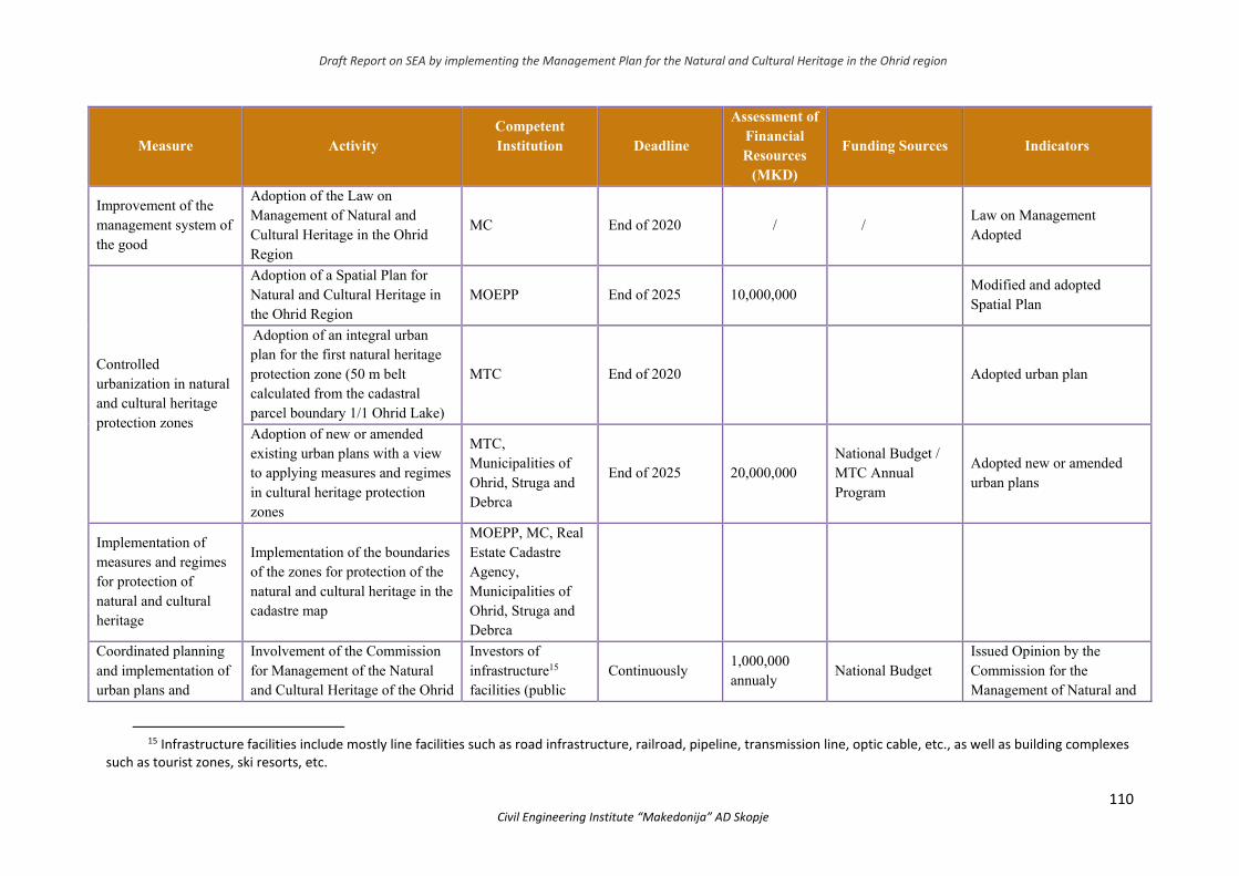
Draft Report on SEA by implementing the Management Plan for the Natural and Cultural Heritage in the Ohrid region
110 Civil Engineering Institute “Makedonija” AD Skopje
Measure Activity Competent Institution
Deadline
Assessment of Financial Resources
(MKD)
Funding Sources Indicators
Improvement of the management system of the good
Adoption of the Law on Management of Natural and Cultural Heritage in the Ohrid Region
MC End of 2020 / / Law on Management Adopted
Controlled urbanization in natural and cultural heritage protection zones
Adoption of a Spatial Plan for Natural and Cultural Heritage in the Ohrid Region
MOEPP End of 2025 10,000,000 Modified and adopted Spatial Plan
Adoption of an integral urban plan for the first natural heritage protection zone (50 m belt calculated from the cadastral parcel boundary 1/1 Ohrid Lake)
MTC End of 2020 Adopted urban plan
Adoption of new or amended existing urban plans with a view to applying measures and regimes in cultural heritage protection zones
MTC, Municipalities of Ohrid, Struga and Debrca
End of 2025 20,000,000 National Budget / MTC Annual Program
Adopted new or amended urban plans
Implementation of measures and regimes for protection of natural and cultural heritage
Implementation of the boundaries of the zones for protection of the natural and cultural heritage in the cadastre map
MOEPP, MC, Real Estate Cadastre Agency, Municipalities of Ohrid, Struga and Debrca
Coordinated planning and implementation of urban plans and
Involvement of the Commission for Management of the Natural and Cultural Heritage of the Ohrid
Investors of infrastructure15 facilities (public
Continuously 1,000,000 annualy
National Budget Issued Opinion by the Commission for the Management of Natural and
15 Infrastructure facilities include mostly line facilities such as road infrastructure, railroad, pipeline, transmission line, optic cable, etc., as well as building complexes
such as tourist zones, ski resorts, etc.
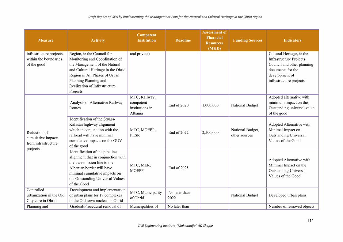
Draft Report on SEA by implementing the Management Plan for the Natural and Cultural Heritage in the Ohrid region
111 Civil Engineering Institute “Makedonija” AD Skopje
Measure Activity Competent Institution
Deadline
Assessment of Financial Resources
(MKD)
Funding Sources Indicators
infrastructure projects within the boundaries of the good
Region, ie the Council for Monitoring and Coordination of the Management of the Natural and Cultural Heritage in the Ohrid Region in All Phases of Urban Planning Planning and Realization of Infrastructure Projects
and private) Cultural Heritage, ie the Infrastructure Projects Council and other planning documents for the development of infrastructure projects
Reduction of cumulative impacts from infrastructure projects
Analysis of Alternative Railway Routes
MTC, Railway, competent institutions in Albania
End of 2020 1,000,000 National Budget
Adopted alternative with minimum impact on the Outstanding universal value of the good
Identification of the Struga-Kafasan highway alignment which in conjunction with the railroad will have minimal cumulative impacts on the OUV of the good
MTC, MOEPP, PESR
End of 2022 2,500,000 National Budget, other sources
Adopted Alternative with Minimal Impact on Outstanding Universal Values of the Good
Identification of the pipeline alignment that in conjunction with the transmission line to the Albanian border will have minimal cumulative impacts on the Outstanding Universal Values of the Good
MTC, MER, MOEPP
End of 2025
Adopted Alternative with Minimal Impact on the Outstanding Universal Values of the Good
Controlled urbanization in the Old City core in Ohrid
Development and implementation of urban plans for 19 complexes in the Old town nucleus in Ohrid
MTC, Municipality of Ohrid
No later than 2022
National Budget Developed urban plans
Planning and Gradual/Procedural removal of Municipalities of No later than Number of removed objects
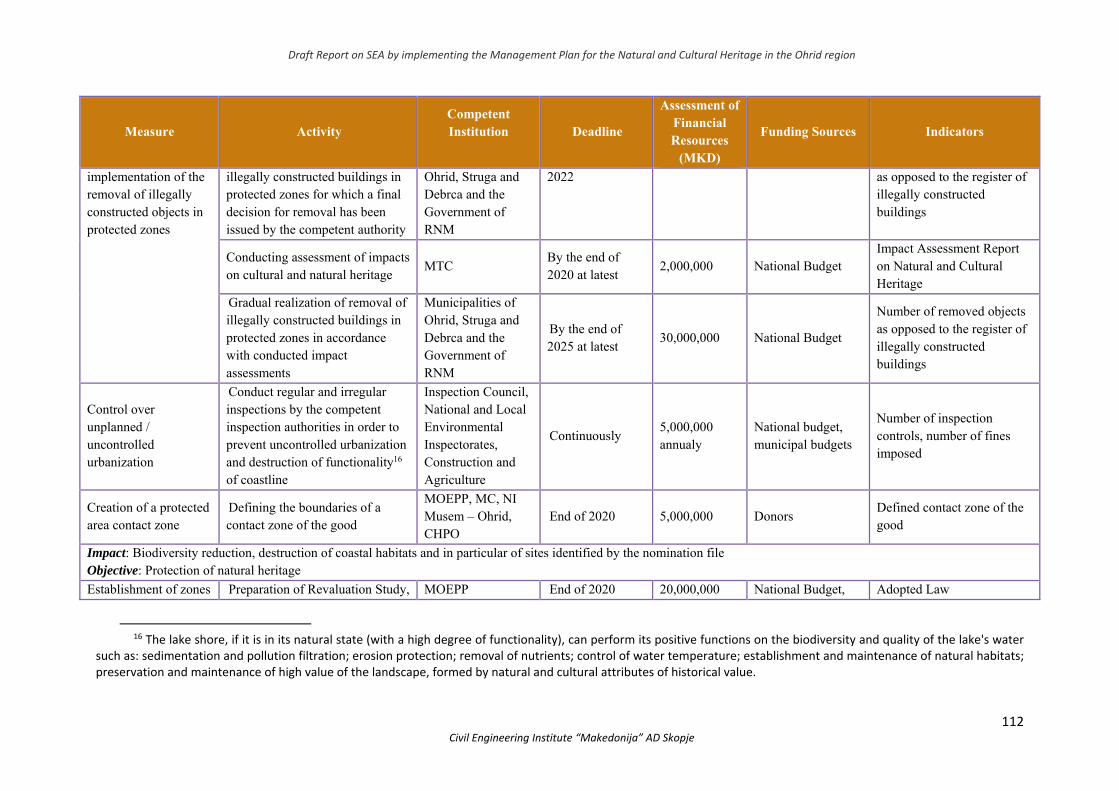
Draft Report on SEA by implementing the Management Plan for the Natural and Cultural Heritage in the Ohrid region
112 Civil Engineering Institute “Makedonija” AD Skopje
Measure Activity Competent Institution
Deadline
Assessment of Financial Resources
(MKD)
Funding Sources Indicators
implementation of the removal of illegally constructed objects in protected zones
illegally constructed buildings in protected zones for which a final decision for removal has been issued by the competent authority
Ohrid, Struga and Debrca and the Government of RNM
2022 as opposed to the register of illegally constructed buildings
Conducting assessment of impacts on cultural and natural heritage
MTC By the end of 2020 at latest
2,000,000 National Budget Impact Assessment Report on Natural and Cultural Heritage
Gradual realization of removal of illegally constructed buildings in protected zones in accordance with conducted impact assessments
Municipalities of Ohrid, Struga and Debrca and the Government of RNM
By the end of 2025 at latest
30,000,000 National Budget
Number of removed objects as opposed to the register of illegally constructed buildings
Control over unplanned / uncontrolled urbanization
Conduct regular and irregular inspections by the competent inspection authorities in order to prevent uncontrolled urbanization and destruction of functionality16 of coastline
Inspection Council, National and Local Environmental Inspectorates, Construction and Agriculture
Continuously 5,000,000 annualy
National budget, municipal budgets
Number of inspection controls, number of fines imposed
Creation of a protected area contact zone
Defining the boundaries of a contact zone of the good
MOEPP, MC, NI Musem – Ohrid, CHPO
End of 2020 5,000,000 Donors Defined contact zone of the good
Impact: Biodiversity reduction, destruction of coastal habitats and in particular of sites identified by the nomination file Objective: Protection of natural heritage
Establishment of zones Preparation of Revaluation Study, MOEPP End of 2020 20,000,000 National Budget, Adopted Law
16 The lake shore, if it is in its natural state (with a high degree of functionality), can perform its positive functions on the biodiversity and quality of the lake's water
such as: sedimentation and pollution filtration; erosion protection; removal of nutrients; control of water temperature; establishment and maintenance of natural habitats; preservation and maintenance of high value of the landscape, formed by natural and cultural attributes of historical value.
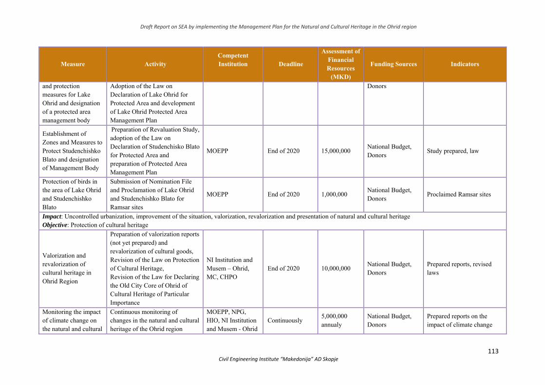
Draft Report on SEA by implementing the Management Plan for the Natural and Cultural Heritage in the Ohrid region
113 Civil Engineering Institute “Makedonija” AD Skopje
Measure Activity Competent Institution
Deadline
Assessment of Financial Resources
(MKD)
Funding Sources Indicators
and protection measures for Lake Ohrid and designation of a protected area management body
Adoption of the Law on Declaration of Lake Ohrid for Protected Area and development of Lake Ohrid Protected Area Management Plan
Donors
Establishment of Zones and Measures to Protect Studenchishko Blato and designation of Management Body
Preparation of Revaluation Study, adoption of the Law on Declaration of Studenchisko Blato for Protected Area and preparation of Protected Area Management Plan
MOEPP End of 2020 15,000,000 National Budget, Donors
Study prepared, law
Protection of birds in the area of Lake Ohrid and Studenchishko Blato
Submission of Nomination File and Proclamation of Lake Ohrid and Studenchishko Blato for Ramsar sites
MOEPP End of 2020 1,000,000 National Budget, Donors
Proclaimed Ramsar sites
Impact: Uncontrolled urbanization, improvement of the situation, valorization, revalorization and presentation of natural and cultural heritage Objective: Protection of cultural heritage
Valorization and revalorization of cultural heritage in Ohrid Region
Preparation of valorization reports (not yet prepared) and revalorization of cultural goods, Revision of the Law on Protection of Cultural Heritage, Revision of the Law for Declaring the Old City Core of Ohrid of Cultural Heritage of Particular Importance
NI Institution and Musem – Ohrid, MC, CHPO
End of 2020 10,000,000 National Budget, Donors
Prepared reports, revised laws
Monitoring the impact of climate change on the natural and cultural
Continuous monitoring of changes in the natural and cultural heritage of the Ohrid region
MOEPP, NPG, HIO, NI Institution and Musem - Ohrid
Continuously 5,000,000 annualy
National Budget, Donors
Prepared reports on the impact of climate change
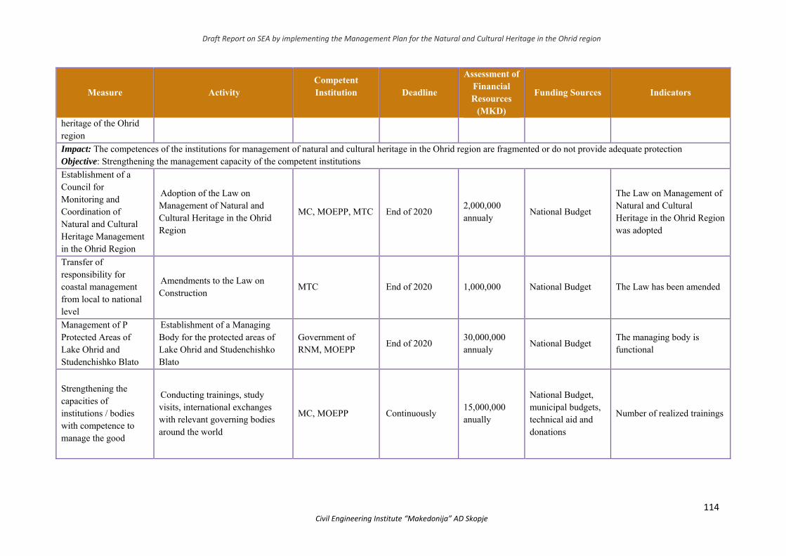
Draft Report on SEA by implementing the Management Plan for the Natural and Cultural Heritage in the Ohrid region
114 Civil Engineering Institute “Makedonija” AD Skopje
Measure Activity Competent Institution
Deadline
Assessment of Financial Resources
(MKD)
Funding Sources Indicators
heritage of the Ohrid region
Impact: The competences of the institutions for management of natural and cultural heritage in the Ohrid region are fragmented or do not provide adequate protection Objective: Strengthening the management capacity of the competent institutions
Establishment of a Council for Monitoring and Coordination of Natural and Cultural Heritage Management in the Ohrid Region
Adoption of the Law on Management of Natural and Cultural Heritage in the Ohrid Region
MC, MOEPP, MTC End of 2020 2,000,000 annualy
National Budget
The Law on Management of Natural and Cultural Heritage in the Ohrid Region was adopted
Transfer of responsibility for coastal management from local to national level
Amendments to the Law on Construction
MTC End of 2020 1,000,000 National Budget The Law has been amended
Management of P Protected Areas of Lake Ohrid and Studenchishko Blato
Establishment of a Managing Body for the protected areas of Lake Ohrid and Studenchishko Blato
Government of RNM, MOEPP
End of 2020 30,000,000 annualy
National Budget The managing body is functional
Strengthening the capacities of institutions / bodies with competence to manage the good
Conducting trainings, study visits, international exchanges with relevant governing bodies around the world
MC, MOEPP Continuously 15,000,000 anually
National Budget, municipal budgets, technical aid and donations
Number of realized trainings
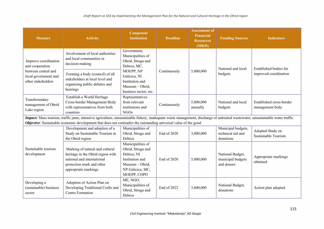
Draft Report on SEA by implementing the Management Plan for the Natural and Cultural Heritage in the Ohrid region
115 Civil Engineering Institute “Makedonija” AD Skopje
Measure Activity Competent Institution
Deadline
Assessment of Financial Resources
(MKD)
Funding Sources Indicators
Improve coordination and cooperation between central and local government and other stakeholders
Involvement of local authorities and local communities in decision-making
Government, Municipalities of Ohrid, Struga and Debrca, MC, MOEPP, NP Galicica, NI Institution and Museum – Ohrid, business sector, etc.
Continuously 5,000,000 National and local budgets
Established bodies for improved coordination Forming a body (council) of all
stakeholders at local level and organizing public debates and hearings
Transboundary management of Ohrid Lake region
Establish a World Heritage Cross-border Management Body with representatives from both countries
Representatives from relevant institutions and NGOs
Continuously 5,000,000 annually
National and local budgets
Established cross-border management body
Impact: Mass tourism, traffic jams, intensive agriculture, unsustainable fishery, inadequate waste management, discharge of untreated wastewater, unsustainable water traffic Objective: Sustainable economic development that does not contradict the outstanding universal value of the good
Sustainable tourism development
Development and adoption of a Study on Sustainable Tourism in the Ohrid region
Municipalities of Ohrid, Struga and Debrca
End of 2020 3,000,000 Municipal budgets, technical aid and donations
Adopted Study on Sustainable Tourism
Marking of natural and cultural heritage in the Ohrid region with national and international protection mark and other appropriate markings
Municipalities of Ohrid, Struga and Debrca, NI Institution and Museum – Ohrid, NP Galicica, MC, MOEPP, CHPO
End of 2020 5,000,000 National Budget, municipal budgets and donors
Appropriate markings obtained
Developing a (sustainable) business sector
Adoption of Action Plan on Developing Traditional Crafts and Centre Formation
МЕ, NGO, Municipalities of Ohrid, Struga and Debrca
End of 2022 3,000,000 National Budget, donations
Action plan adopted
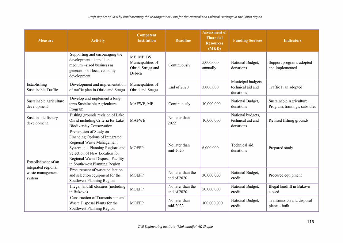
Draft Report on SEA by implementing the Management Plan for the Natural and Cultural Heritage in the Ohrid region
116 Civil Engineering Institute “Makedonija” AD Skopje
Measure Activity Competent Institution
Deadline
Assessment of Financial Resources
(MKD)
Funding Sources Indicators
Supporting and encouraging the development of small and medium –sized business as generators of local economy development
МЕ, МF, BS, Municipalities of Ohrid, Struga and Debrca
Continuously 5,000,000 annually
National Budget, donations
Support programs adopted and implemented
Establishing Sustainable Traffic
Development and implementation of traffic plan in Ohrid and Struga
Municipalities of Ohrid and Struga
End of 2020 3,000,000 Municipal budgets, technical aid and donations
Traffic Plan adopted
Sustainable agriculture development
Develop and implement a long-term Sustainable Agriculture Program
MAFWE, MF Continuously 10,000,000 National Budget, donations
Sustainable Agriculture Program, trainings, subsidies
Sustainable fishery development
Fishing grounds revision of Lake Ohrid including Criteria for Lake Biodiversity Conservation
MAFWE No later than 2022
10,000,000 National budgets, technical aid and donations
Revised fishing grounds
Establishment of an integrated regional waste management system
Preparation of Study on Financing Options of Integrated Regional Waste Management System in 4 Planning Regions and Selection of New Location for Regional Waste Disposal Facility in South-west Planning Region
MOEPP No later than mid-2020
6,000,000 Technical aid, donations
Prepared study
Procurement of waste collection and selection equipment for the Southwest Planning Region
MOEPP No later than the end of 2020
30,000,000 National Budget, credit
Procured equipment
Illegal landfill closures (including in Bukovo)
MOEPP No later than the end of 2020
50,000,000 National Budget, credit
Illegal landfill in Bukovo closed
Construction of Transmission and Waste Disposal Plants for the Southwest Planning Region
MOEPP No later than mid-2022
100,000,000 National Budget, credit
Transmission and disposal plants - built

Draft Report on SEA by implementing the Management Plan for the Natural and Cultural Heritage in the Ohrid region
117 Civil Engineering Institute “Makedonija” AD Skopje
Measure Activity Competent Institution
Deadline
Assessment of Financial Resources
(MKD)
Funding Sources Indicators
Reconstruction of the wastewater treatment plant, the collector and the sewage networks in the settlements along Lake Ohrid
Implementation of project documentation for the reconstruction of the collector, sewerage networks and the treatment plant
MOEPP, EP Collector System
No later than the end of 2030
30 billion National Budget, credit
The collector and the wastewater treatment plant are operational
Sustainable visits management
Preparing a Visitor Plan
MOEPP, NI NP Galicica, Port Captain – Ohrid, Municipalities od Ohrid, Debrca and Struga
No later than the end 2020
5,000,000 National Budget, donations
Visitor Plan
Sustainable agriculture Preparing a Sustainable Agriculture Program in the good
MAFWE No later than the end of 2022
10,000,000 National Budget, donations
Sustainable Agriculture Program
Mass tourism management and introduction of sustainable tourism
Preparing Analysis of the impact and consequences of uncontrolled tourism development and assessment of the capacity of endurance (carrying capacits)
МЕ-ТS (Ministry of Economy – Tourism Sector), MC, MOEPP, ОLG, SLG, DLG (in original: ЛСО, ЛСС, ЛСД –local self-government of Ohrid, Struga and Debrca), Musem - Ohrid, NGO
2021 5,000,000 National Budget, donations
Assessment of endurance capacity made (carrying capacits)
Impact: Low awareness of the importance of good and ecosystem services for the sustainable economic development of the region Objective: Raising awareness and education
Continuous education of the population and
Developing and implementing an Education Program
МЕ-TS, МC, MOEPP ,
Continuously 2,000,000 annually
National Budget, donations
Developed Education Program
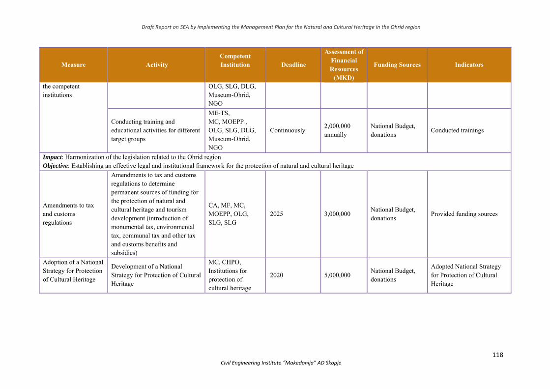
Draft Report on SEA by implementing the Management Plan for the Natural and Cultural Heritage in the Ohrid region
118 Civil Engineering Institute “Makedonija” AD Skopje
Measure Activity Competent Institution
Deadline
Assessment of Financial Resources
(MKD)
Funding Sources Indicators
the competent institutions
OLG, SLG, DLG, Museum-Ohrid, NGO
Conducting training and educational activities for different target groups
МЕ-TS, МC, MOEPP , OLG, SLG, DLG, Museum-Ohrid, NGO
Continuously 2,000,000 annually
National Budget, donations
Conducted trainings
Impact: Harmonization of the legislation related to the Ohrid region Objective: Establishing an effective legal and institutional framework for the protection of natural and cultural heritage
Amendments to tax and customs regulations
Amendments to tax and customs regulations to determine permanent sources of funding for the protection of natural and cultural heritage and tourism development (introduction of monumental tax, environmental tax, communal tax and other tax and customs benefits and subsidies)
CA, MF, MC, MOEPP, OLG, SLG, SLG
2025 3,000,000 National Budget, donations
Provided funding sources
Adoption of a National Strategy for Protection of Cultural Heritage
Development of a National Strategy for Protection of Cultural Heritage
MC, CHPO, Institutions for protection of cultural heritage
2020 5,000,000 National Budget, donations
Adopted National Strategy for Protection of Cultural Heritage
Draft Report on SEA by implementing the Management Plan for the Natural and Cultural Heritage in the Ohrid region
119 Civil Engineering Institute “Makedonija” AD Skopje
7. ALTERNATIVE SOLUTIONS ANALYSIS
7.1 Introduction
Within the SEA it is necessary that the “reasons for the choice of the alternative solution are stated”. In the case of this SEA of the Management Plan for the Natural ad Cultural Heritage, the following alternative solutions were rewieved:
“No changes“ scenario: this assumes that the management plan is not adopted.
Alternative management approaches: these are summarized alternative management responses with the purpose of including the proposed infrastructure projects. This section provides an overview of the additional alternatives considered by Investors of planned development projects identified by the SEA in order to avoid and/or minimize any potential significant residual impacts.
Alternative Contact Zone Solutions Although the SEA provides an overview of alternative solutions to infrastructure projects, it does not provide a detailed analysis of alternative solutions by several criteria. This should be an EIA study task at the project level. The key strategic issues at which project-level alternative solutions differ are highlighted within the SEA
7.2 “No changes” scenario
The “no changes“ scenario refers to the alternative solution – not to implement the Plan, i.e. not to implement the proposed activities for OUV presevration of the Ohrid Region. It is assumed that the current starting state od the “natural” areas in the region shal continue “as it is” and shall have additional risk of urbanization along the shoreline. The consequences of the “no changes“ scenario are given below, and the following should be underscored:
Unless the Management Plan for the Natural and Cultural Heritage of the Ohrid Region is adopted, there is a threat of damaging, destroying or seriously disrupting the integrity. This is due to the accelerated decline caused by undertaking larger projects, urban and tourist development, disruption due to changes in the use or ownership of land as well as significant changes which occur for unknown reasons, neglect, endangerment due to war activities, climate changes, fires, water level changes, floods and occurrence of natural disasters.
There is also danger of loss of authenticity of the original shapes (form, concept, materials, use and function, traditions and techniques, location and setting as well as other internal and
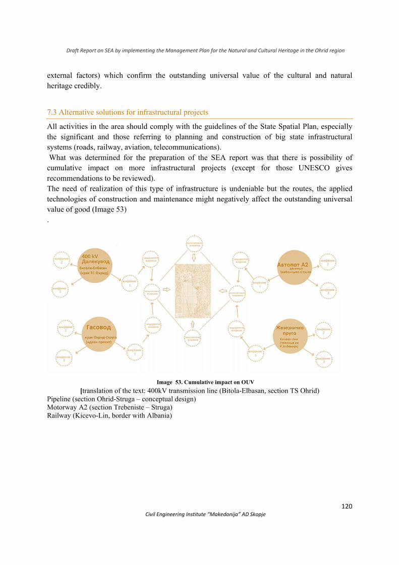
Draft Report on SEA by implementing the Management Plan for the Natural and Cultural Heritage in the Ohrid region
120 Civil Engineering Institute “Makedonija” AD Skopje
external factors) which confirm the outstanding universal value of the cultural and natural heritage credibly.
7.3 Alternative solutions for infrastructural projects
All activities in the area should comply with the guidelines of the State Spatial Plan, especially the significant and those referring to planning and construction of big state infrastructural systems (roads, railway, aviation, telecоmmunications). What was determined for the preparation of the SEA report was that there is possibility of cumulative impact on more infrastructural projects (except for those UNESCO gives recommendations to be reviewed). The need of realization of this type of infrastructure is undeniable but the routes, the applied technologies of construction and maintenance might negatively affect the outstanding universal value of good (Image 53) .
Image 53. Cumulative impact on OUV
[translation of the text: 400kV transmission line (Bitola-Elbasan, section TS Ohrid) Pipeline (section Ohrid-Struga – conceptual design) Motorway A2 (section Trebeniste – Struga) Railway (Kicevo-Lin, border with Albania)
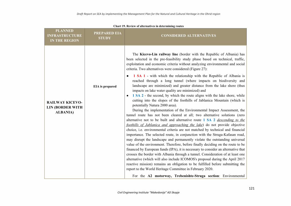
Draft Report on SEA by implementing the Management Plan for the Natural and Cultural Heritage in the Ohrid region
121 Civil Engineering Institute “Makedonija” AD Skopje
Chart 19. Review of alternatives in determining routes
PLANNED INFRASTRUCTURE
IN THE REGION
PREPARED EIA STUDY
CONSIDERED ALTERNATIVES
RAILWAY KICEVO-LIN (BORDER WITH
ALBANIA)
EIA is prepared
The Kicevo-Lin railway line (border with the Republic of Albania) has been selected in the pre-feasibility study phase based on technical, traffic, exploitation and economic criteria without analyzing environmental and social criteria. Two alternatives were considered (Figure 27):
● 1 SA 1 - with which the relationship with the Republic of Albania is reached through a long tunnel (where impacts on biodiversity and landscape are minimized) and greater distance from the lake shore (thus impacts on lake water quality are minimized) and
● 1 SA 2 - the second, by which the route aligns with the lake shore, while cutting into the slopes of the foothills of Jablanica Mountain (which is potentially Natura 2000 area). During the implementation of the Environmental Impact Assessment, the
tunnel route has not been cleared at all; two alternative solutions (zero alternative not to be built and alternative route 1 SA 2 descending to the foothills of Jablanica and approaching the lake) do not provide objective choice, i.e. environmental criteria are not matched by technical and financial importance. The selected route, in conjunction with the Struga-Kafasan road, may disrupt the landscape and permanently violate the outstanding universal value of the environment. Therefore, before finally deciding on the route to be financed by European funds (IPA), it is necessary to consider an alternative that crosses the border with Albania through a tunnel. Consideration of at least one alternative (which will also include ICOMOS's proposal during the April 2017 reactive mission) remains an obligation to be fulfilled before submitting the report to the World Heritage Committee in February 2020.
For the A2 motorway, Trebenishte-Struga section: Environmental
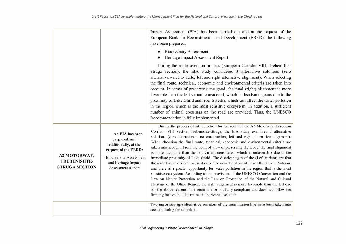
Draft Report on SEA by implementing the Management Plan for the Natural and Cultural Heritage in the Ohrid region
122 Civil Engineering Institute “Makedonija” AD Skopje
Impact Assessment (EIA) has been carried out and at the request of the European Bank for Reconstruction and Development (EBRD), the following have been prepared:
● Biodiversity Assessment ● Heritage Impact Assessment Report
During the route selection process (European Corridor VIII, Trebenishte-Struga section), the EIA study considered 3 alternative solutions (zero alternative - not to build, left and right alternative alignment). When selecting the final route, technical, economic and environmental criteria are taken into account. In terms of preserving the good, the final (right) alignment is more favorable than the left variant considered, which is disadvantageous due to the proximity of Lake Ohrid and river Sateska, which can affect the water pollution in the region which is the most sensitive ecosystem. In addition, a sufficient number of animal crossings on the road are provided. Thus, the UNESCO Recommendation is fully implemented.
А2 MOTORWAY, TREBENISHTE-
STRUGA SECTION
An EIA has been prepared, and
additionally, at the request of the EBRD:
- Biodiversity Assessment and Heritage Impact Assessment Report
During the process of site selection for the route of the A2 Motorway, European Corridor VIII Section Trebenishte-Struga, the EIA study examined 3 alternative solutions (zero alternative - no construction, left and right alternative alignment). When choosing the final route, technical, economic and environmental criteria are taken into account. From the point of view of preserving the Good, the final alignment is more favorable than the left variant considered, which is unfavorable due to the immediate proximity of Lake Ohrid. The disadvantages of the (Left variant) are that the route has an orientation, ie it is located near the shore of Lake Ohrid and r. Sateska, and there is a greater opportunity for water pollution in the region that is the most sensitive ecosystem. According to the provisions of the UNESCO Convention and the Law on Nature Protection and the Law on Protection of the Natural and Cultural Heritage of the Ohrid Region, the right alignment is more favorable than the left one for the above reasons. The route is also not fully compliant and does not follow the limiting factors that determine the horizontal solution.
Two major strategic alternative corridors of the transmission line have been taken into
account during the selection.
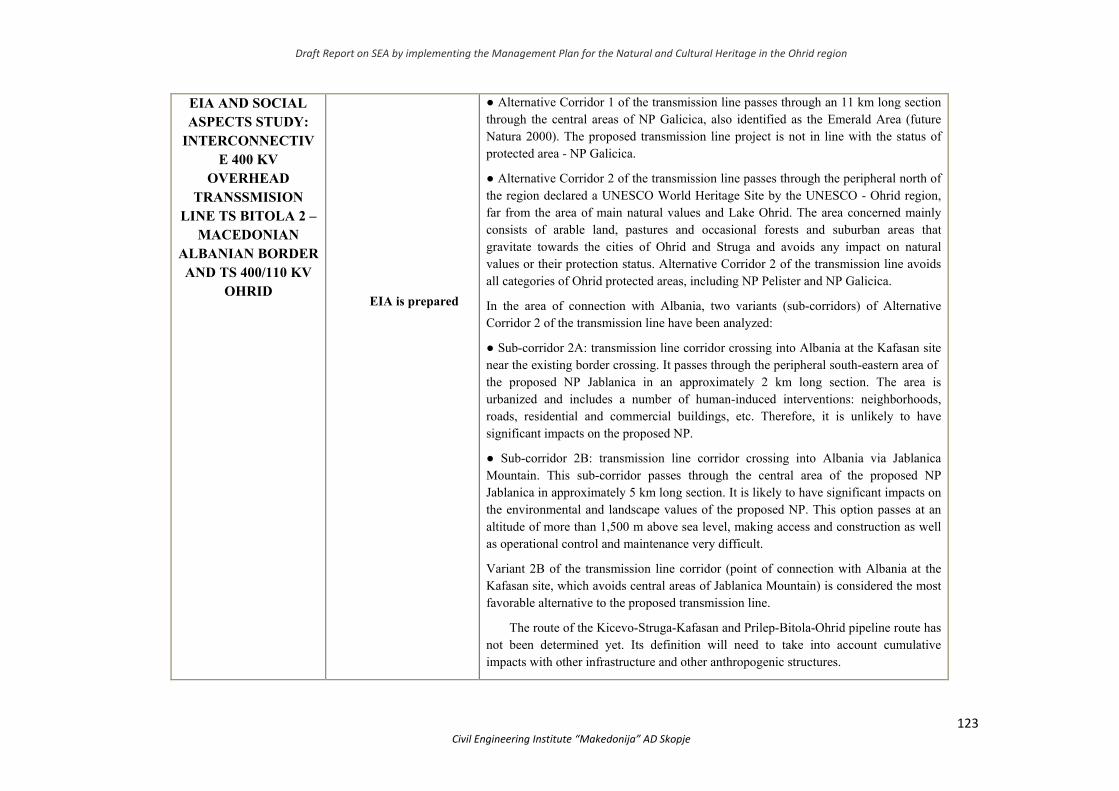
Draft Report on SEA by implementing the Management Plan for the Natural and Cultural Heritage in the Ohrid region
123 Civil Engineering Institute “Makedonija” AD Skopje
EIA AND SOCIAL ASPECTS STUDY:
INTERCONNECTIVE 400 KV
OVERHEAD TRANSSMISION
LINE TS BITOLA 2 – MACEDONIAN
ALBANIAN BORDER AND TS 400/110 KV
OHRID
EIA is prepared
● Alternative Corridor 1 of the transmission line passes through an 11 km long section through the central areas of NP Galicica, also identified as the Emerald Area (future Natura 2000). The proposed transmission line project is not in line with the status of protected area - NP Galicica.
● Alternative Corridor 2 of the transmission line passes through the peripheral north of the region declared a UNESCO World Heritage Site by the UNESCO - Ohrid region, far from the area of main natural values and Lake Ohrid. The area concerned mainly consists of arable land, pastures and occasional forests and suburban areas that gravitate towards the cities of Ohrid and Struga and avoids any impact on natural values or their protection status. Alternative Corridor 2 of the transmission line avoids all categories of Ohrid protected areas, including NP Pelister and NP Galicica.
In the area of connection with Albania, two variants (sub-corridors) of Alternative Corridor 2 of the transmission line have been analyzed:
● Sub-corridor 2A: transmission line corridor crossing into Albania at the Kafasan site near the existing border crossing. It passes through the peripheral south-eastern area of the proposed NP Jablanica in an approximately 2 km long section. The area is urbanized and includes a number of human-induced interventions: neighborhoods, roads, residential and commercial buildings, etc. Therefore, it is unlikely to have significant impacts on the proposed NP.
● Sub-corridor 2B: transmission line corridor crossing into Albania via Jablanica Mountain. This sub-corridor passes through the central area of the proposed NP Jablanica in approximately 5 km long section. It is likely to have significant impacts on the environmental and landscape values of the proposed NP. This option passes at an altitude of more than 1,500 m above sea level, making access and construction as well as operational control and maintenance very difficult.
Variant 2B of the transmission line corridor (point of connection with Albania at the Kafasan site, which avoids central areas of Jablanica Mountain) is considered the most favorable alternative to the proposed transmission line.
The route of the Kicevo-Struga-Kafasan and Prilep-Bitola-Ohrid pipeline route has not been determined yet. Its definition will need to take into account cumulative impacts with other infrastructure and other anthropogenic structures.
Draft Report on SEA by implementing the Management Plan for the Natural and Cultural Heritage in the Ohrid region
124 Civil Engineering Institute “Makedonija” AD Skopje
NATIONAL GASIFICATION SYSTEM IN ТHE
REPUBLIC OF NORTH
MACEDONIA, OHRID-STRUGA
SECTION
The project is not up to that stage
/
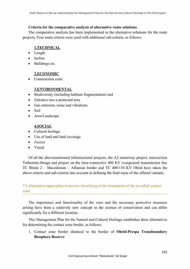
Draft Report on SEA by implementing the Management Plan for the Natural and Cultural Heritage in the Ohrid region
125 Civil Engineering Institute “Makedonija” AD Skopje
Criteria for the comparative analysis of alternative route solutions The comparative analysis has been implemented to the alternative solutions for the route
projects. Four main criteria were used with additional sub-criteria, as follows:
1.ТECHNICAL Length
Incline
Bulidings etc.
2.ECONOMIC
Construction costs
3.ENVIRONMENTAL Biodiversity (including habitats fragmentation) and
Entrance into a protected area
Gas emission, noise and vibrations
Soil
Area/Landscape
4.SOCIAL
Cultural heritage
Use of land and land coverage
Access
Visual Of all the abovementioned infrastructural projects, the A2 motorway project, intercection
Trebeniste-Struga and project on the inter-connective 400 KV overground transmission line ТС Bitola 2 – Macedonian – Albanian border and ТС 400/110 KV Оhrid have taken the above criteria and sub-criteria into account in defining the final route of the offered variants.
7.4 Alternative approaches to precise identifying of the boundaries of the so called contact zone
The importance and functionality of the zone and the necessary protective measures arising have been a relatively new concept in the science of conservation and can differ significantly for a different location.
This Management Plan for the Natural and Cultural Heirtage establishes three alternatives for determining the contact zone border, as follows:
1. Contact zone border identical to the border of Ohrid-Prespa Transboundary Biosphere Reserve
Draft Report on SEA by implementing the Management Plan for the Natural and Cultural Heritage in the Ohrid region
126 Civil Engineering Institute “Makedonija” AD Skopje
2. Contact zone border – smaller than that of the Ohrid-Prespa Transboundary Biosphere Reserve, but includes Prespa Lake
3. Contact zone border – smaller but does not include Prespa Lake. It does include the outside border of National Park Galicica thoigh.
The contact zone includes the immediate surroundings of the good, so as to protect the views from and to the sites possessing outstanding universal values as well as to include areas functionally related to the protected areas.
Defining the contact zone borders shall be done through extensive consulting process which shall take the three alternatives of this Draft-Plan into account and shall determine the area, features and land uses; the contact zone border shall be included within the nomination file and shall represent a modification of the border of good. This border shall be put into the cadastre plan and shall move along existing relief parcels.
Taking into account the fact in July 2019, the Albanian part of Ohrid Lake was written down in the list of UNESCO world heritage, in order to keep the integrity of the good, the cotact zone border at the Albanian side was taken into account in the review.
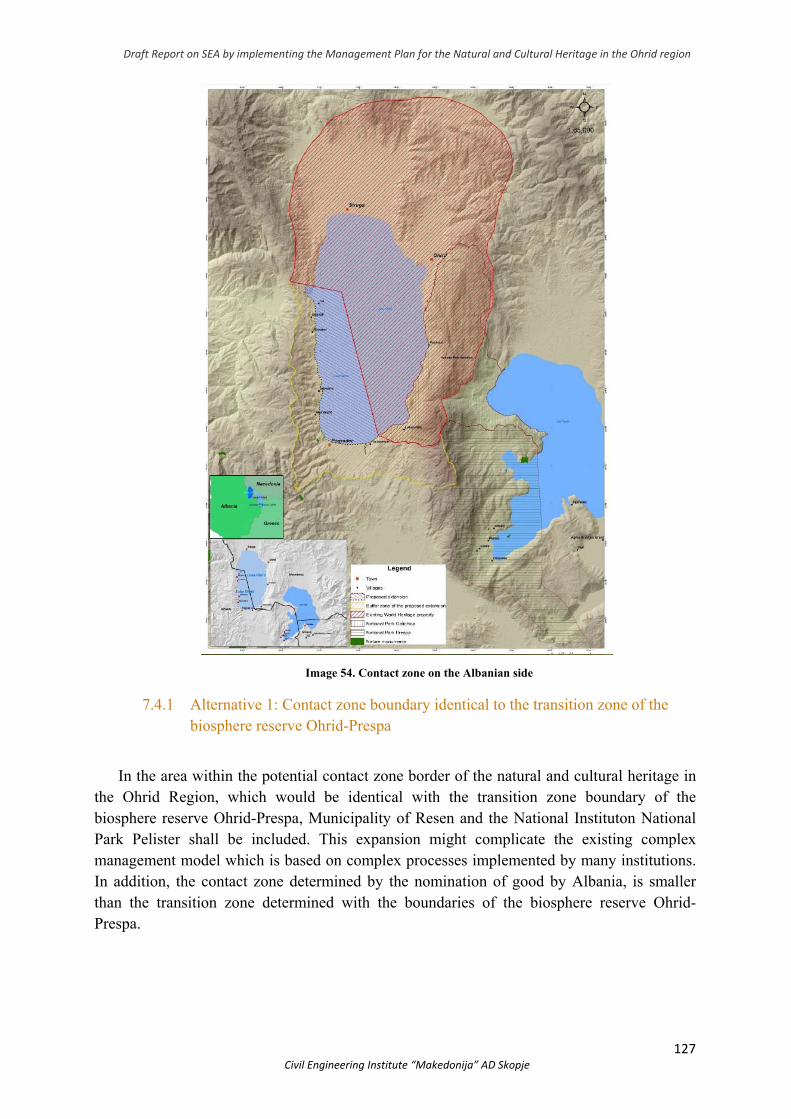
Draft Report on SEA by implementing the Management Plan for the Natural and Cultural Heritage in the Ohrid region
127 Civil Engineering Institute “Makedonija” AD Skopje
Image 54. Contact zone on the Albanian side
7.4.1 Alternative 1: Contact zone boundary identical to the transition zone of the biosphere reserve Ohrid-Prespa
In the area within the potential contact zone border of the natural and cultural heritage in the Ohrid Region, which would be identical with the transition zone boundary of the biosphere reserve Ohrid-Prespa, Municipality of Resen and the National Instituton National Park Pelister shall be included. This expansion might complicate the existing complex management model which is based on complex processes implemented by many institutions. In addition, the contact zone determined by the nomination of good by Albania, is smaller than the transition zone determined with the boundaries of the biosphere reserve Ohrid-Prespa.
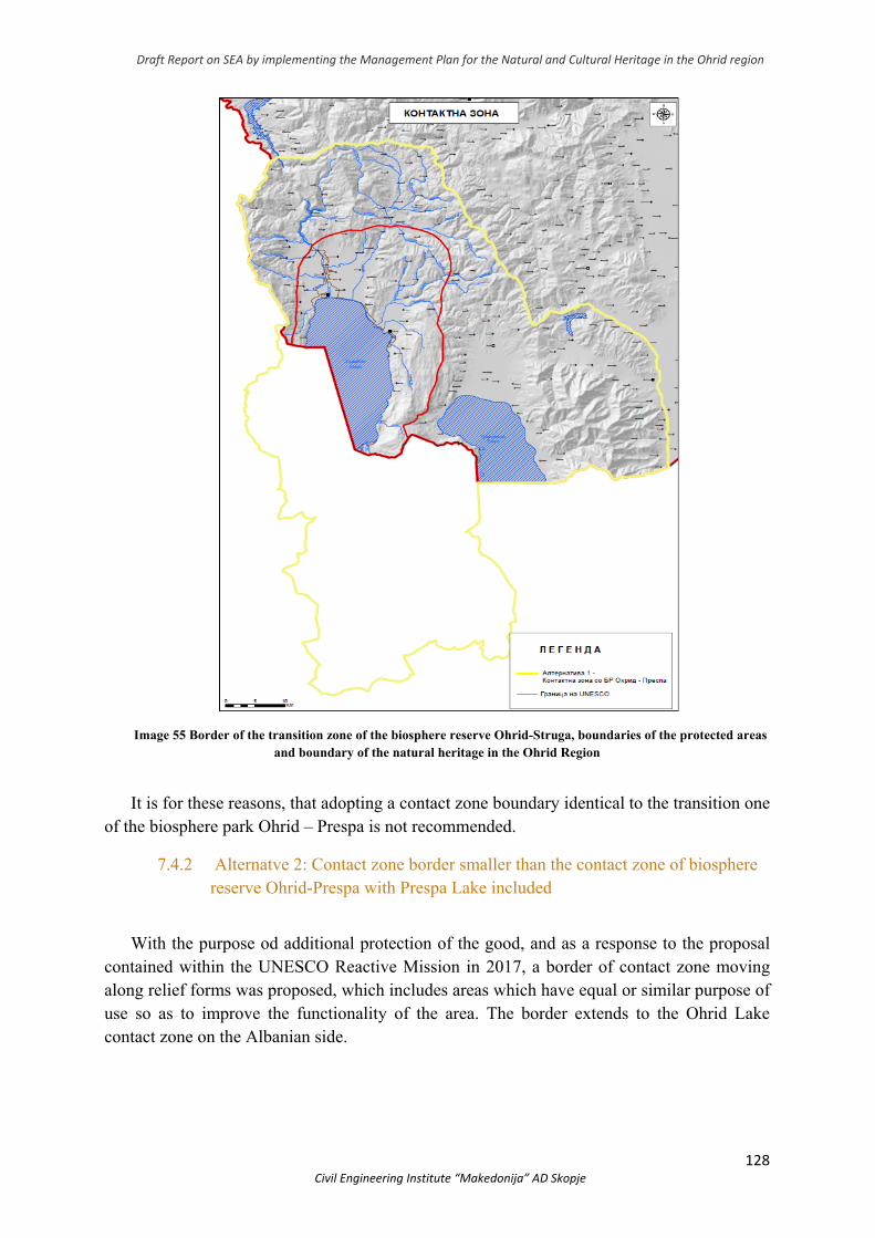
Draft Report on SEA by implementing the Management Plan for the Natural and Cultural Heritage in the Ohrid region
128 Civil Engineering Institute “Makedonija” AD Skopje
Image 55 Border of the transition zone of the biosphere reserve Ohrid-Struga, boundaries of the protected areas and boundary of the natural heritage in the Ohrid Region
It is for these reasons, that adopting a contact zone boundary identical to the transition one of the biosphere park Ohrid – Prespa is not recommended.
7.4.2 Alternatve 2: Contact zone border smaller than the contact zone of biosphere reserve Ohrid-Prespa with Prespa Lake included
With the purpose od additional protection of the good, and as a response to the proposal contained within the UNESCO Reactive Mission in 2017, a border of contact zone moving along relief forms was proposed, which includes areas which have equal or similar purpose of use so as to improve the functionality of the area. The border extends to the Ohrid Lake contact zone on the Albanian side.

Draft Report on SEA by implementing the Management Plan for the Natural and Cultural Heritage in the Ohrid region
129 Civil Engineering Institute “Makedonija” AD Skopje
Image 56 Boundary of the natural and cultural heritage in the Ohrid Region and proposal for the contact zone
smaller than the one of the biosphere reserve Ohrid-Struga which includes Prespa Lake
By adopting this alternative contact zone, the Municipality of resen shall be included which can additionally complicate the existing management model. Regarding the necessary protection which needs to be provided by the contact zone, this proposal has its advantages since by including Prespa Lake, the connection of it to Ohrid Lake is being recognized.
7.4.3 Alternative 3: Contact zone boundary smaller than the contact zone of biosphere reserve Ohrid-Prespa without Prespa Lake
This alternative boundary of the contact zone in its starting part is almost identical to the second alternative but instead of including Prespa Lake, is continues downward to south and
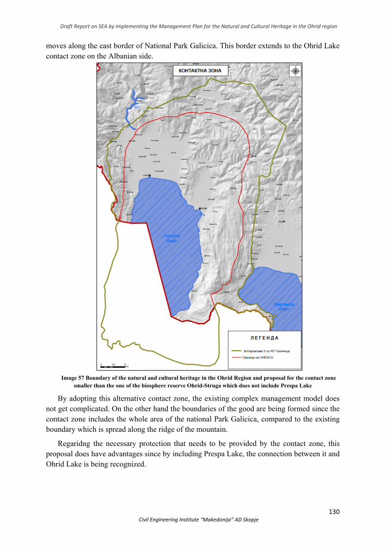
Draft Report on SEA by implementing the Management Plan for the Natural and Cultural Heritage in the Ohrid region
130 Civil Engineering Institute “Makedonija” AD Skopje
moves along the east border of National Park Galicica. This border extends to the Ohrid Lake contact zone on the Albanian side.
Image 57 Boundary of the natural and cultural heritage in the Ohrid Region and proposal for the contact zone
smaller than the one of the biosphere reserve Ohrid-Struga which does not include Prespa Lake
By adopting this alternative contact zone, the existing complex management model does not get complicated. On the other hand the boundaries of the good are being formed since the contact zone includes the whole area of the national Park Galicica, compared to the existing boundary which is spread along the ridge of the mountain.
Regaridng the necessary protection that needs to be provided by the contact zone, this proposal does have advantages since by including Prespa Lake, the connection between it and Ohrid Lake is being recognized.
Draft Report on SEA by implementing the Management Plan for the Natural and Cultural Heritage in the Ohrid region
131 Civil Engineering Institute “Makedonija” AD Skopje
8. POSSIBLE SIGNIFICANT IMPACT OF THE PLANNING DOCUMENT ON THE ENVIRONMENT
The Ohrid Region Heritage Management Plan is the basis for an integrated natural and cultural heritage management system in such a way that it will control different types of activities that will contribute to:
Controlling the urbanization;
Strengthenning the management capacities of the competent institutions;
Protection of natural and cultural heritage;
Raising awareness and education;
Increasing the ecological functionality of the coast.
This chapter shall identify the potential positive and negative impacts of implementing the
Action Plan. The Strategic Assessment Report takes into account the impacts on water, air, soil, biodiversity, landscapes and their landscape values, natural and cultural heritage, as well as the impacts on the socio-economic situation and human health in the Ohrid Region (Ohrid, Struga and Debrca). Generally, implementing the planning solutions is aimed at having a positive impact on the environment and social aspects.
It should also be noted that the Strategic Assessment Report does not include a detailed analysis of individual development projects, but rather analyzes the impacts on the media and environmental areas in a broader context. The Report assesses the potential environmental impacts and socio-economic aspects, while, at a later stage, through Environmental Impact Assessment Studies or Environmental protection Analyses, which arise as a legal obligation on the basis of the identified potential negative impacts, detailed analysis and recommendations are made.
Pursuant to the Law on Environment and the Criterion Determination Decree, and on the basis of which the need for conducting an environmental impact assessment procedure is determined, it is necessary to determine the need for conducting an environmental impact assessment procedure. The Environmental Impact Assessment shall be adopted by the body of the state administration responsible for the affairs of the environment. According to the Law on Environment, as well as the Law on Nature Protection, the legal entities or natural persons that perform activities or activities that are not part of the projects for which an environmental impact assessment procedure is carried out are obliged to prepare an Environmental Impact Assessment Report, in order to assess the impact of the activities or activities on the environment, before commencing the implementation of the project and forwarding it to the body responsible for approving the implementation of the project.
In analysing the impacts, special attention will be paid to the impacts on the protected World Heritage, especially Lake Ohrid. During the evaluation, stakeholders were consulted on this protected area.
If the implementation of some of the measures and activities arising from the Plan were not addressed properly and with a pre-set dynamic, additional negative impacts on the media and environmental areas would be expected. Part of the Action Plan expected to impact the environmental media is:
Draft Report on SEA by implementing the Management Plan for the Natural and Cultural Heritage in the Ohrid region
132 Civil Engineering Institute “Makedonija” AD Skopje
1. Reconstruction of the collector and sewer networks in the settlements along Lake Ohrid and the wastewater treatment plan,
2. Construction of Waste Transfer and Waste Disposal Plants for the South-West Planning Region,
3. Demolition of illegal buildings in protected areas for which a final demolition decision has been issued by the competent authority.
Key impacts are likely to relate to:
Risk of pollution and sedimentation of Lake Ohrid during construction works (especially demolition on the coast);
Emissions to air and noise during the construction phase which may cause consequences for the flora and fauna;
Impacts on cultural heritage due to construction activities especially in the old town nucleus;
Discomfort from air emissions and noise during the construction phase for the local population.
Planned actions such as demolition and reconstruction of buildings in the coastal zone can lead to deterioration of hydrology, lake water quality, biodiversity, landscape values and adversely affect the preservation of: old city architecture, coastal structure, structure of the old city cores of Ohrid and Struga and the surrounding areas with historical monuments.
A detailed analysis of the type of impacts at all stages of the project should be undertaken for each of the Actions individually. All project phases such as facility construction, demolition, operational phase, case of sudden emergency and in case of project termination should be analyzed in terms of impact of all project activities on all environmental elements in EIA studies or elaborates (as previously stated).
Two of the identified impacts have so far been subject to an environmental impact assessment:
Impacts that would result from the reconstruction of the collector system are elaborated in the Lake Ohrid Environmental Data Collection Study and Collector System Rehabilitation Techniques, DZAJKA (ЏАЈКА), 2015.
Impact analysis that would result from the construction of the waste transfer and disposal plant for the Southwest Planning Region was carried out in the context of the SEA and EIA Regional Waste Management Plan for the Southwest Region.
For the demolition of illegal buildings in protected areas for which an Effective Demolition Decision has been issued by the competent authority, it is necessary to prepare an Elaborate for Demolition of Illegal Buildings in accordance with the Law on Construction and Separate Environmental Impact Assessment and Heritage Impact Assessment. Based on previously known information, the environmental risks of these activities are unlikely to be significant and long-lasting and may be mitigated by typical construction control measures.
8.1 Impact on air quality
Implementing the measures set out in the Action Plan will indirectly improve air quality, population health and mitigate climate change. The main impacts of the Acts on the air quality in the area are expected during the reconstruction of the wastewater treatment
Draft Report on SEA by implementing the Management Plan for the Natural and Cultural Heritage in the Ohrid region
133 Civil Engineering Institute “Makedonija” AD Skopje
plant, collector and sewer networks, construction of relocation and waste transfer and disposal facilities for the Southwest Planning Region and demolition of illegal buildings in the protected areas for which a Final Demolition Decision has been issued by the competent authority. The different types of vehicles, equipment and construction machinery to be used in construction, reconstruction and demolition are mobile sources of emissions of pollutants the most characteristic of which are NOx, CO, PM10, unburnt hydrocarbons, sulfur, lead, benzene and other aromatic hydrocarbons that contribute to the secondary generation of ozone and all present a direct and indirect risk to human health and the environment. Fuel quality in North Macedonia is within European standards and is controlled in accredited laboratories. Emissions of combustion substances and their negative impacts are of low intensity, locally and through the distribution of pollutants affects the air quality in the area. Increased frequency of vehicles for delivery of construction materials, goods and labor transport into and out of the subject areas is expected as a long-term and cumulative process. Potential impacts on air quality as a result of demolition include dust emissions generated during construction and land clearing and demolition work.
Specific significant air quality impacts will be provided for the environmental impact assessment of each specific activity / project, which will be implemented and will certainly receive appropriate treatment with mitigation and elimination measures. Preventive measures for emission reductions, continuous monitoring and reporting to competent authorities should be envisaged. Efficient use of fuels and energy as well as finding opportunities to use renewable energy sources must be imperative in meeting the objectives of the plan and future projects.
For those projects for which Environmental Impact Assessments have already been developed and mitigation measures have been implemented, their implementation is required
8.2 Impact On Water Quality And Quantity
The implementation of most of the actions in the plan is aimed at improving the water quality in the Lake Ohrid Basin. However, there are activities elaborated in the general impacts that are considered to cause significant adverse impacts on surface and groundwater. It must be noted that the impacts will have a direct impact on the water quality of Lake Ohrid.
Generally speaking, during construction activities one would expect:
increased turbidity and sediment due to accidental release into immediate water bodies;
Increased load on the sewage sediment and infrastructure. Any impacts are expected to be temporary and generally localized in the area of
associated active work, but may have longer-term impacts on local ecological communities. Groundwater quality may be compromised during demolition due to the manipulation
of construction machinery and other construction activities (earthworks, etc.). Handling of fuels such as petroleum, lubricants and paints (for protection of metal structures etc.) as well as handling of wastes arising from the maintenance of machinery (parts, wastewater, used lubricants, etc.) is another risk for surface and groundwater pollution.
Draft Report on SEA by implementing the Management Plan for the Natural and Cultural Heritage in the Ohrid region
134 Civil Engineering Institute “Makedonija” AD Skopje
One of the major adverse effects resulting from the infiltration of petroleum products into the groundwater is the reduction processes that destroy oxygen in the water and are caused by the decomposition of petroleum products. Groundwater may be endangered by the eventual release of grease and oil from construction machinery during construction. Due to the fact that these impacts are characterized as short term, however, the organization of the site should ensure that these potential impacts are kept to a minimum.
It is particularly important to take good construction practice measures that will prevent preventive impacts of the project activities on the water.
As stated in the Study by DZAJKA (ЏАЈКА) during the construction phase of the collector system reconstruction one would not expect water pollution in the lake. However, there is the possibility of pollution originating mainly from delayed solid waste of different origin (usually municipal mixed waste and inert construction waste). Washing of this waste and its disintegration will be a source of water pollution in Lake Ohrid.
The individually expected negative impact analysis will be analyzed in further environmental impact assessments of each individual activity/project.
For those projects for which Environmental Impact Assessments have already been developed and mitigation measures have been implemented, their implementation is required.
8.3 Impact On Soil
Implementation of the planned measures to achieve the objectives, in particular the technical measures, which include measures to improve the collection system and wastewater treatment plant, implementation of good agricultural practices in agricultural production, good forestry and fisheries practices and so on will provide sustainable land use and planning.
There will also be a negative impact on the soil in case of inadequate management of wastewater and generated waste. Demolition of illegal buildings will disrupt the geological characteristics of the soil, as a result of the use of heavy machinery and vehicles, transport and disposal of excess excavated material, disposal of construction waste (rubble), etc. No soil impacts are expected during the reconstruction of the collector system.
8.4 Impact on landscape
Implementation of the planning document is aimed at proper spatial organization and protection of the OUV of the good.
During the construction of the collector and the demolition of buildings, the visual appearance of the landscape will change shortly as a result of activities undertaken on the ground in the form of demolition, digging, coming and the presence of large transport vehicles, trucks and other machinery required for transportation of building materials and structures, electricity, water supply and sewage disposal at the site in question as well as waste management.
However, no significant negative impact is expected as the purpose of those activities is precisely to improve the visual effects, as well as the fact that it is an underground operating infrastructure.
Due to the sensitive location in the construction phase effects on the landscape and visual aspects are expected. These impacts will be expressed through the presence of construction machinery, equipment, vehicles, workers and stored building materials.
Draft Report on SEA by implementing the Management Plan for the Natural and Cultural Heritage in the Ohrid region
135 Civil Engineering Institute “Makedonija” AD Skopje
Changes will cause different sensations in the receptors. However, they will be short-term changes during construction. Impacts will be local, of short duration, irreversible, high magnitude/intensity and significant.
A detailed analysis of the type of impacts at all stages of the project should be undertaken for each of the Actions individually. All phases of the project such as investigative work, facility construction, operational phase of the project, case of sudden breakdown and in case of project termination should be analyzed in terms of impact of all project activities on all environmental elements in the studies for EIA or analyses. For those projects for which Environmental Impact Assessments have already been developed and mitigation measures have been implemented, their implementation is required.
8.5 Impact On Socio-economic Situation
With the Plan implementation, the local population living and working in the region may be affected. The activities will enable the development of sustainable tourism, thereby creating new jobs and increasing employment of the population (especially young people), developing sustainable agricultural production and products that comply with European quality standards, increasing crop yields and income, sustainable land use and planning that will contribute to socio-economic benefits locally and nationally. Opening up employment opportunities will contribute to retaining the country's young educated staff and reducing the migration trend.
The implementation of the envisaged measures for raising public awareness and education will also contribute to increasing the education and awareness of the population about the importance of the good, active involvement of the population in decision making, which will directly or indirectly improve the well-being of the population.
By restoring order, the entire coastline, especially Ramsar localities can be put into operation and used for educational purposes but also for selective tourist offerings. Hence, the importance of preserving bog ecosystems is of great importance for the socio-economic progress of the population in the region.
However, the activities proposed may also have negative economic impacts, expressed through additional financial costs to the population, expressed through increased fees in the form of taxes / compensations, or for homeowners declared to be World Heritage Sites would mean maintenance costs and restoration. Prohibition or restrictions on certain activities in certain zones can cause negative socio-economic impacts.
According to the study, a 500 m2 Dzajka Surface will be covered by the reconstruction and no human settlements of the collector system will be affected. Impact on soil is not expected. The introduction of coastal protection regimes, including recreational zones, as well as regimes in the old town nucleus, would mean a newly emerging situation for which locals must be prepared. Implementation of these measures may also affect the local population, due to the possible occupation of private property, changes in current lifestyle, economic losses to the community caused by the implementation of activities, etc.
Demolition of illegal buildings will disrupt nearby commodity due to workers' presence, construction machinery, noise, vibration and dust. Changes can affect local residents, owners of commercial buildings near the construction site, domestic and foreign visitors to the city of Ohrid, etc.
Draft Report on SEA by implementing the Management Plan for the Natural and Cultural Heritage in the Ohrid region
136 Civil Engineering Institute “Makedonija” AD Skopje
8.6 Impact On Population And Human Health
Implementation of the measures in the Plan will contribute to the protection of the media and environmental areas, in particular surface and ground water, biodiversity, material goods, and population health. Lake level regulation will solve the longstanding problem detected in the municipality of Struga.
Much of the measures lead to improving the situation of the population. Developing and implementing a traffic plan in Ohrid and Struga will solve the problem these municipalities have especially during the tourist seasons and cause inconvenience to the locals. During the implementation of the Plan, it is possible that significant impacts could be adversely affecting human health if no safeguards are envisaged. Unplanned demolition of buildings is expected to have negligible direct impacts on human health (noise, vibration, vehicle air emissions, dust, etc.). Given that this Strategic Impact Assessment is undertaken at an early stage of the planning process, the application of appropriate measures and recommendations can be effective in preventing pollution and protecting human health. A detailed analysis of the human health impacts of the individual projects should be part of the appropriate environmental impact assessment documentation
8.7 Impact On Cultural Heritage
It is evident that the implementation of the activities will contribute to reducing the threats and improving the state of cultural heritage. But also activities involving construction activities can contribute to the emergence of new conditions, possible sources of emissions and threats to cultural heritage. Particularly important in determining the potential impacts of construction activities on cultural heritage is the location, taking into account the fact that some of the illegal buildings are located in the old city cores and on the shores of Lake Ohrid.
The demolition of buildings in the old town nuclei in Ohrid and Struga could have a negative effect on individual protected goods within the whole.
The demolition of buildings in the shoreline of Lake Ohrid could have a negative effect, especially in areas where protected cultural heritage is registered, such as:
1. Monastery complex St. Archangel Michael (St. Naum); 2. Monastery complex St. Mother of God Zahumska – Zaum, near village Trpejca; 3. Monastery complex St. Mother of God - Kalishta; 4. St. Archangel Michael in village Radozda; 5. St. John the Theologian - Kaneo. Construction work in the project area can also cause negative impacts on cultural heritage,
with expected impacts being manifested through several activities: - Impacts of using construction machinery and vibration presence; - Impacts of construction waste and building materials; - Impacts by disrupting the normal functioning of the surrounding good during
construction works.
Draft Report on SEA by implementing the Management Plan for the Natural and Cultural Heritage in the Ohrid region
137 Civil Engineering Institute “Makedonija” AD Skopje
Specific significant impacts on cultural heritage will be foreseen for each specific activity/project, which will be implemented within the planning scope and will certainly receive appropriate treatment with measures to reduce and eliminate them. These tasks are for later stages, through the preparation of Environmental Impact Assessment Studies, Cultural Heritage Impact Assessment Studies or Environmental Impact Analyses, which arise as a legal obligation based on potential adverse impacts, detailed analysis and recommendations are made.
8.8 Impact On Biodiversity (Flora And Fauna)
Implementation of the Plan will have a positive impact on biodiversity through: harmonization of legislation with the requirements of the Convention on Natural and Cultural Heritage and other relevant international documents, amending and adopting bylaws related to urban planning issues in the Ohrid Region, laws, updating existing relevant strategies and action plans that address the issues of the Good, controlled urbanization in accordance with the protection zones and regimes in the area of good, including issues related to the good in sectoral strategic documents in the areas of agriculture, forestry, water management and spatial planning, (Example Fisheries Audit on Lake Ohrid Including Criteria for Conservation of Lake Biodiversity) additional specification of competences between institutions at central and local level, as well as other stakeholders in problem solving, creating a mechanism for effective vertical and horizontal coordination of the institutions in the planning and implementation of activities.
Implementation of the activities will result in changes in future urban planning and land use planning, improvement of land use status, biodiversity conservation, water use and water management that will have a direct positive impact on all media and areas of the environment, especially biodiversity.
Demolition of buildings in the shoreline of Lake Ohrid could have a negative effect, especially if there is a natural heritage site that has Outstanding Universal Values such as:
1. Kalishta – the only natural habitat of the Yellow Nymphaea (Nuphar lutea) in Ohrid Lake;
2. Podmolje - the most widespread reed belt (Phragmites australis) on Lake Ohrid, a natural habitat for endangered bird species and carp hatchery;
3. Mazija - Revitalized natural habitat of the Nuphar lutea, carp and nesting habitat and bird nest;
4. Studenchishko Blato - macrophytic vegetation and breeding ground of carp fish;
5. Veli-Dab – sublacustrine springs, trout breeding ground and benthic biodiversity;
6. Velja-Pesh - sublacustrine springs, trout plains and benthic fauna biodiversity;
7. Sveti Petar - coastal and sublacustrine springs, trout hatchery and benthic biodiversity;
8. Sveti Naum Springs - the most prominent source of Lake Ohrid, trout and carp fish hatchery and benthic fauna biodiversity.
Draft Report on SEA by implementing the Management Plan for the Natural and Cultural Heritage in the Ohrid region
138 Civil Engineering Institute “Makedonija” AD Skopje
The construction work in the project area can cause negative impacts on the habitat (macrophyte vegetation littoral zone) and the wildlife living in that habitat. The expected impacts will be manifested through several activities:
- Impacts of fuel leaks, fats and oils - Impacts of construction waste and building materials
Inappropriate construction practices would result in negative impacts on plant communities with very limited distribution, as well as on the types of macroinvertebrates and algae found only in those sites and nowhere else in the world. Construction works will affect waterfowl as the reed belt is an important refuge and nesting along the shores of Lake Ohrid.
Technical implementation of infrastructure projects and systems reconstruction /construction/demolition activities can cause adverse impacts on the sites where they will be implemented and the intensity of impacts will depend on site selection, sensitive receptors, and development activities in areas where they will be built. These impacts will be discussed in more detail at the EIA / elaborate level.
Further consideration of the impacts on biodiversity and the planning of appropriate pollution prevention and control measures should be done at the level of technical and project documentation in the known technical details. Given the expected impacts it is necessary to carry out an environmental impact assessment of the project. In the context of more well-known details, and depending on the scope and needs, for other smaller related projects it may be necessary to conduct an environmental impact assessment.
8.9 Impacts Related To Waste Management
Waste management is generally a problem for the whole region due to inadequate municipal waste collection, inaccessibility for the collection and transport of municipal waste at certain sites and the existence of landfills Some of the measures in the Plan are aimed at addressing the regional problem of waste management.
From the individual activities listed in the general impacts, certain fractions of inert and non-hazardous waste can be expected. The impact at this stage is expected to be local and without significant features. In the construction phase, most of the waste would come from site clearance activities with a view to initiating exploitation, clearing the site and setting up the necessary infrastructure.
The Strategic Impact Assessment of the Regional Waste Management Plan integrally takes into account the landfill and other waste management infrastructure in order to assess the total potential or cumulative impacts. Remediation of irregular landfills and landfills should also follow a pre-environmental assessment where appropriate measures to prevent and reduce the impacts of the closure and remediation activities should be identified specific to the site.
The construction of the collector and the demolition of buildings will in itself generate a significant amount of waste especially during the construction phase.
Technical implementation of infrastructure projects and activities can cause adverse effects on the media and environmental areas in the areas where they will be implemented and the intensity of impacts will depend on site selection, sensitive receptors, operation and
Draft Report on SEA by implementing the Management Plan for the Natural and Cultural Heritage in the Ohrid region
139 Civil Engineering Institute “Makedonija” AD Skopje
maintenance of facilities, and development. activities in the areas where they will take place. These impacts will be discussed in more detail at the level of specific planning/project documentation in the SEA reports and EIA documents, studies/reports.
8.10 Impact Of Noise
Implementation of the Plan may have an environmental impact from noise emissions. During the construction/reconstruction and demolition phase, the occurrence of noise is related to the work of heating machinery and transport vehicles and can largely be avoided. The impact is expected to be discontinuous, local and timely constrained during the construction phase.
During the operational phase, activities of demolition from mechanization, machinery and the like are expected to be of particular interest. Depending on the demolition plans, demolition could be from once, several times a day to several times a week. Detailed assessments of the potential impacts that would take into account all activities at this stage and the circumstances of the environment are necessary. Based on this, it is necessary to identify the extent and intensity of the impacts of noise both in the construction phase and in particular in the operational phase, should be detailed and appropriately identified and evaluated within the study, ie environmental reports).
8.11 Cumulative Impact
Taking into account all the activities that are in the Action Plan, positive and negative cumulative impacts are expected. They would be positive because of the synergistic nature of measures to improve the state of natural and cultural heritage. Negative cumulative and synergistic impacts are also identified through the emission of harmful pollutants into the air from the machinery involved, ie increased traffic and dust, odor and noise during construction works that could occur during the simultaneous demolition of illegal buildings.
Negative cumulative and synergistic impacts can occur on surface and ground water, soil, biodiversity if the location of landfills and waste treatment sites is not selected through an environmental impact assessment procedure and is not handled in a manner such as as prescribed in domestic law. However, implementation of the plan will greatly reduce the present adverse impact on surface and groundwater resulting from current waste treatment.
8.12 Impacts of Accidents And Breakdowns
Implementation of the planning document can be affected by accidents and breakdowns that can be expressed through:
- Risk of electrical danger; - Risk of explosion; - Risk of fire; - Risk of earthquake; - Meteorological phenomena with characteristic of natural disasters, floods; - Incidents and accidents caused by different defects and technological disasters; - Possibility of major pollution of the surface and ground water due to accidents when
transporting harmful substances, but also permanent micro-pollution.
Draft Report on SEA by implementing the Management Plan for the Natural and Cultural Heritage in the Ohrid region
140 Civil Engineering Institute “Makedonija” AD Skopje
The dangers of using electricity should be addressed when designing and constructing buildings within urban areas. The risk of explosion and fire is present both in the construction phase and in the functional phase.
Natural disasters can be earthquakes, which can have catastrophic consequences on humans and nature. The Ohrid Region is a seismically active area, which means that the area is in a zone of expected earthquakes. Natural disasters or catastrophes can also be floods and rise of large waters, waves from the lake and other meteorological phenomena that may have the character of natural disasters and catastrophes are: hail occurrence, strong winds and fogs.
Because of its terrain configuration, it is at risk from two types of flood hazards, namely groundwater flooding and torrential rainwater flooding. The immediate proximity of Lake Ohrid is also a risk. Technical-technological disasters, such as major accidents and breakdowns, can occur during facility operation. Therefore it is necessary to prepare an emergency and accident management plan that will be an integral part of the study, i.e. the project impact study on the environment and human health.
8.13 Transboundary Impacts
The recognition of the transboundary nature of natural and cultural resources is reflected in a number of trnasboundary plans, agreements and labels, such as:
Agreement between the Council of Ministers of the Republic of Albania and the Government of the Republic of North Macedonia for protection and sustainable development of Lake Ohrid Basin (Skopje, 2004);
Galicica is included in the transboundary Park Prespa in 2000 and 2010;
Ohrid-Prespa Transboundary Biosphere Reserve, 2014.
All impacts on transboundary resources or plan impacts that transcend competences become tranboundary. Considering the discussion of the impact assessment outlined above as a result of the adoption of a management plan, including project implementation, the following transboundary impacts may occur: Impacts / risks on the Lake may include quality impairment, changes in hydrology, habitat loss and biodiversity etc. These effects may also reflect the economic and social aspects. It is particularly important to note that these risks and effects are present on both sides of the lake (Albania and North Macedonia).
In short, the impacts (positive and negative) of the adoption of the proposed Management Plan are unlikely to have any significant cross-border impacts. However, the cumulative risk to the area's cultural and natural heritage can cause concern among various international partners, both in neighboring countries and international agencies. With regard to transboundary agreements, transboundary stakeholders should be consulted regarding the adoption of the management plan, as well as any implications for the different transboundary agreements. Public consultation on the draft Plan and the SEA is therefore required.
Draft Report on SEA by implementing the Management Plan for the Natural and Cultural Heritage in the Ohrid region
141 Civil Engineering Institute “Makedonija” AD Skopje
9. MEASURES AND RECOMMENDATIONS FOR PROTECTION, REDUCTION AND NEUTRALIZATION OF NEGATIVE IMPACTS
The Impact Analysis found that the implementation of the measures and activities contained
in the Action Plan will contribute to the sustainable management of good in the Ohrid region. Each of the activities is intended to reduce the existing problems affecting the media and the environment, so it is considered that the impacts of the Plan are considered positive and their implementation will achieve conservation of the natural heritage and sustainable development of the area, as well as and meeting environmental objectives. It should be noted that many of the measures provide guidance for the preparation and/or modification of the legal framework, strategies, plans, programs and projects. Some of them are of a regulatory nature, and part of them is the realization of specific projects, which will additionally be subject to a procedure for more detailed environmental impact assessment.
From the above-mentioned impacts that cover construction activities in general, good design practice and organization of construction sites can minimize much of the impacts identified for the construction phase. Also, environmental management methods will greatly mitigate the impacts identified for the operational phase
The measures recommended by this Report will need to be considered in the next stages of planning. The final measures, determined by the exact location, type and scope of activities, will be defined through procedures for specific planning documentation or at project level through EIA studies or environmental studies (for each project / facility individually). In this way environmental protection measures will be incorporated into the project and taken into account during construction.
What is particularly important and the purpose of strategic planning is to provide control over the implementation of the measures and activities of the Plan in line institutions, local governments, public enterprises and the private sector. For this purpose it is necessary to:
Prepare Information to the Government of the Republic of North Macedonia with a detailed analysis of the legal obligations stemming from signed national and international agreements in all sectoral policies and their alignment, with financial implications, to avoid collisions / contradictions;
Ensure cooperation and coordination with line ministries and institutions in order to achieve compliance of the measures deriving from the Plan with sectoral strategic and planning documents and activities covering the same time frame, and even more with future sector strategies and plans;
Extensive cross-sectoral cooperation, discussion and alignment.
9.1 Measures to protect, reduce and mitigate the negative impact on air quality
Impacts on ambient air would be expected during construction (collector reconstruction) or demolition of illegal buildings in protected areas. The measure proposes demolition to take place in advance of a plan for a gradual demolition. Several measures are proposed:
Demolish in such a way as to cause minimal disruption to the immediate surroundings;
Draft Report on SEA by implementing the Management Plan for the Natural and Cultural Heritage in the Ohrid region
142 Civil Engineering Institute “Makedonija” AD Skopje
The demolition process should be in accordance with the requirements of all relevant authorities (local authorities, ministries responsible for public infrastructure) and in accordance with the Law on the Treatment of Illegally Constructed Buildings;
Develop a Dust Management Plan. The amount of dust created will depend on the size of the demolished building/facility as
well as the method and equipment used during the demolition process. Mitigation measures include:
Using the best available technology in the demolition process;
Appropriate security measures, such as information boards;
Demolition to take place in light winds to reduce dust emissions;
Sprinkle the soil with water so that it does not reduce the quality of the air created by dust and solid particles.
It should also be emphasized that the specific mitigation measures will (or are already in the EIA studies, only need to be respected) are defined in the environmental impact studies/analysis for each facility individually.
9.2 Measures to protect, reduce and mitigate the negative impact on water quality
During the implementation of the actions of the Plan, the quality of groundwater may be jeopardized during the construction phase due to the manipulation of construction machinery and other construction activities (earthworks, etc.). These impacts were characterized as short-term, however, the organization of the site should ensure that these potential impacts are kept to a minimum.
When carrying out any of the activities of the Plan, existing natural sewers and watercourses in or near the site should not be restricted. This recommendation applies in particular to Lake Ohrid.
Specific water mitigation measures will be defined in the environmental impact studies/analysis for each facility individually.
9.3 Measures to protect, reduce and mitigate the negative impact on soil
Soil quality indirectly affects the quality of water and groundwater, so it is necessary to provide for appropriate measures to prevent and reduce soil impacts.
During the construction activities it is necessary to carefully remove the surface layer of soil, not to excavate more than planned, as well as the excess soil to be used or to be returned and compacted. Construction waste should be disposed of at temporary landfills intended for that purpose and then dislocated.
Before proceeding with the action envisaged in the Plan, it is necessary to prepare a separate report on how to remove the existing building, which will provide solutions for the treatment of the construction debris created by the removal of the previously constructed building.
It is particularly important to indicate in advance the method of supply of the site with electricity and water, the way of connection of the site to the existing traffic and the method
Draft Report on SEA by implementing the Management Plan for the Natural and Cultural Heritage in the Ohrid region
143 Civil Engineering Institute “Makedonija” AD Skopje
of treatment of the construction waste (construction debris) produced on the site itself and - a graphical diagram containing an organization scheme of the construction site and method of connecting the existing construction site to the existing highways.
It is especially important that construction workers working on demolition of illegal buildings in protected areas be educated about the significance of the site and the possible adverse impacts before they begin activities. Specific soil mitigation measures will be defined in the environmental impact studies/analysis for each facility individually..
9.4 Measures to protect, reduce and mitigate the negative impact on the landscape
The anticipated demolition of illegal buildings would have a serious impact on the landscape and require careful approach in order to preserve heritage and other public interests.
In order to mitigate impacts during the construction phase, the following general measures are recommended:
Apply good construction practice to the construction site;
Advanced planning and organization of construction activities for appropriate construction dynamics;
During construction, dust reduction measures should be applied thoroughly as recommended;
Disposal of construction waste on the construction site is not allowed;
Limit the construction site to a smaller area. Specific mitigation measures will be defined in the environmental impact assessments
for each facility individually.
9.5 Measures to protect, reduce and mitigate the negative impact on socio-economic characteristics
In order to mitigate the impacts on socio-economic aspects it is proposed:
Subsidizing alternative forms of tourism;
Providing support (spatial, technical, financial, etc.) to the local population for starting new businesses or applying agri-environmental measures in agriculture;
Providing financial support, expressed through favorable subsidies and loans to farmers, in accordance with the Government's agricultural policy, in order to implement the envisaged actions;
Educating different groups of beneficiaries on the importance of UNESCO status in the region;
Preparation of informative material and organizing information meetings with different groups of beneficiaries on the application of measures for protection of natural and cultural heritage, thus achieving their protection and at the same time achieving socio-economic benefits;
Establish a financial framework for meeting the objectives and measures with certain benefits for the vulnerable categories.
Specific mitigation measures for social aspects will be defined in the environmental impact studies /analysis for each facility individually.
Draft Report on SEA by implementing the Management Plan for the Natural and Cultural Heritage in the Ohrid region
144 Civil Engineering Institute “Makedonija” AD Skopje
9.6 Measures to protect, reduce and mitigate the negative impact on the population and human health
In order to reduce the impacts on the population and human health, it is necessary to
provide and implement measures for protection of all environmental media and areas, as well as the working environment, during the construction phase. In this way, the health and well-being of the population and workers are directly and indirectly protected. Implementation of the planning document is generally expected to have a positive long-term impact on the population.
Implementation of all proposed measures separately by different impacts, starting from the planning phase, through the construction phase will enable the prevention and control of the identified impacts, which may directly or indirectly reflect on the population and human health.
In order to monitor the effectiveness of the implemented preventive and control measures, it is necessary to establish a good clear monitoring plan that will monitor the operation of the activity and all its processes, and inform the competent authorities accordingly.
9.7 Measures to protect, reduce and mitigate the negative impact on cultural heritage
The general measures that can be envisaged for the protection of cultural heritage are:
- Compliance with EIA measures, analyses, as well as studies for strategic assessment of cultural heritage protection;
- Implementation of the measures envisaged for proper management of space and waste will indirectly mitigate negative impacts on cultural heritage.
When establishing impact mitigation measures, it is necessary to follow the guidelines for permitted/unauthorized activities in the protection regime zone specified in the Management Plan. They should be included in the main projects according to the assessment of the impact on the cultural heritage within the studies, ie studies for environmental protection.
In order to secure cultural heritage during demolition activities, it is necessary to implement the following measures:
Approved project for the removal of a building or part thereof under the Building Act (Article 99 and Article 99-a);
All legal procedures and measures provided for under the Building Act, Section Removal (from Articles 99 to 106);
Elaborate on the impact of removing the building on the Heritage Impact Assessment (HIA);
Preparation of protection and conservation conditions and obtaining Protection - Conservation Consent;
Draft Report on SEA by implementing the Management Plan for the Natural and Cultural Heritage in the Ohrid region
145 Civil Engineering Institute “Makedonija” AD Skopje
During the whole period of construction activities, five days a week, an expert appointed by the NI Institute for Protection of Monuments of Culture and Museum - Ohrid and designated civil engineer should monitor the place and condition of cultural heritage in the project area;
Workers who will be working on this project should be informed and educated about
the importance of Ohrid and its cultural heritage..
9.8 Measures to protect, reduce and mitigate the negative impact on biodiversity (flora and fauna)
In order to secure habitats and protect wildlife during demolition activities, the
following measures are necessary: • The Contractor should prepare a Biodiversity Management Plan for the project activities
that would take place on the coast where the OUV sites are; • Restoration of the habitats after the completion of the construction activities; • Construction activities should be carried out in periods of low water levels; • During the entire period of construction/reconstruction/demolition activities at least once
a week, an independent expert (biologist/ecologist) should monitor the location and condition of the habitat and wildlife in the project area;
• Workers who will be working on this project should be informed and educated about the importance of Lake Ohrid and its wildlife.
Prior to work, protective fencing around trees should be set in accordance with the Biodiversity Management Plan. Maintenance and temporary fencing around trees and monitoring the condition throughout the demolition process.
- Implementation of the measures envisaged for the proper management of space, wastewater and waste will indirectly mitigate negative impacts on flora and fauna;
- Application of administrative compensation measures, compensation of lost habitats and prohibition of construction.
When establishing impact mitigation measures, it is necessary to follow the guidelines for permitted/prohibited activities for the Sustainable Use Zone of Galicica NP listed in the Environmental Management Plan. They should be included in the construction projects in accordance with the environmental impact assessment of the studies, ie environmental studies.
- All activities planned to comply with the positive legislation of the Republic of North Macedonia regulating the protection of the environment, nature, as well as the management of protected areas, as well as the higher planning documents. In addition, the planned activities should be harmonized with the international agreements and conventions that the Republic of North Macedonia has signed them and they refer to the Ohrid region;
- In order to protect and preserve the good, all envisaged activities should be in accordance with the principles of protection of natural and cultural heritage.
Due to the fact that one would expect interventions in coastal areas where there are illegal structures and at the same time are sites with endemic plant and animal species and are
Draft Report on SEA by implementing the Management Plan for the Natural and Cultural Heritage in the Ohrid region
146 Civil Engineering Institute “Makedonija” AD Skopje
the breeding ground for many cyprinid fish, the Public Scientific Institution Hydrobiological Institute-Ohrid should be familiar with the activities and directly included in the process.
Specific mitigation measures for biodiversity will be defined in the environmental impact studies/analyses for each facility individually.
9.9 Measures to protect, reduce and mitigate the negative impact of the planning document on waste management
The contractor is required to prepare a Waste Management Program for the construction phase. The program must contain:
• Identification of different types of waste and the quantities that will be generated during the construction phase in accordance with the List of Waste Types (Official Gazette of the Republic of North Macedonia no. 100/05);
• Selection and classification of different types of waste, in accordance with the List of waste types and its submission to authorized companies;
• Determine the treatment of different types of waste; • Establish a waste management procedure; • Provide containers and waste storage locations; • Defining the time for waste collection and transportation from the site; • Reuse the excavated soil as much as possible; • Reuse of other types of waste; • Determine the estimated value for recyclable waste reuse; • Establish monitoring of waste management measures; • Training of staff on proper waste treatment. It is also recommended: • Full implementation of the measures and recommendations of the Waste Management
Program: agreement with the Environmental Impact Assessment and Social Assessment Study from an authorized company for waste collection, transport and treatment and its acceptance;
• Hiring an authorized waste manager to ensure full implementation of the Program in accordance with legal recommendations;
• Inert waste/construction debris to be disposed of at the Maucker landfill or other disposal site proposed by the municipality.
The waste that will be generated during the construction of the planned facilities will be disposed of at a construction site designated by the municipal services. To avoid the environmental impacts caused by inappropriate waste management during the operational phase, the principle of waste hierarchy, ie prevention, reuse, recycling, processing, treatment and disposal of residual quantities of waste that cannot be reused, will be applied.
The environmental elaborates for the individual facilities will identify the types and quantities of waste generated at the sites and the possibilities for its reduction and recycling.
Draft Report on SEA by implementing the Management Plan for the Natural and Cultural Heritage in the Ohrid region
147 Civil Engineering Institute “Makedonija” AD Skopje
9.10 Measures to protect, reduce and mitigate the negative impact of the planning document on noise
Measures envisaged to prevent and reduce noise are: - Preparing and publishing a plan for starting and finishing works; - Keep an eye on the working hours due to the possibility of noise disturbance (from
07.00 to 17.00); - To use new machines technically sound and less noisy; - The existing and planned surface with protective greenery can significantly contribute to
the protection and reduction of noise impacts; Specific measures for mitigation of environmental impacts will be defined in the
environmental impact studies /analysis for each project.
9.11 Measures to protect, reduce and mitigate cumulative and transboundary impacts
The risks of cumulative impacts are discussed in Chapter 8. These impacts are best dealt with by reducing the overall impact of each activity, as recommended in the sections above.
The impact of the Projects, including their cumulative impact, should be monitored periodically to identify whether any modifications or revisions to the operational parameters of the Projects are needed to control adverse impacts. Continuous monitoring regime with sufficient resources for the Hydrobiological Institute is recommended.
To address transboundary impacts, the Project-level measures discussed above, and the different measures that will be identified at the Project EIA stage, should be respected. However, the current Monitoring Plan will identify whether there are ongoing issues that raise concerns about impacts and should select any issue that could become cross-border. Recommendations for cross-border consultation and communication are mandatory, as the Espoo Convention itself states.
9.12 Measures to protect, reduce and mitigate impacts from accidents and disasters
For the purpose of organized implementation of protection and rescue, participants in the protection and rescue system should adopt a Plan for protection and rescue from natural disasters, epidemics, epizootics, epiphytotics and other accidents. The protection and rescue plan contains preventive and operational measures, activities and procedures for protection and rescue. The plan is adopted by the Municipal Council. Protection and rescue measures are mandatory applied:
- Planning and arranging the space and settlements; - Projects for construction and technological processes intended for the storage,
production and use of hazardous substances, oil and its derivatives, energy gases, public transport, ferrous and non-ferrous metallurgy, as well as for public, administrative, cultural and tourist-catering activities;
- To construct facilities and infrastructure facilities. In order to regulate the space, the following must be provided:
• Construction of buildings resistant to seismic activity; • Regulation of watercourses and construction of a system of defensive embankments;
Draft Report on SEA by implementing the Management Plan for the Natural and Cultural Heritage in the Ohrid region
148 Civil Engineering Institute “Makedonija” AD Skopje
• Construction of snow protection belts and bare forestation; • Provision of fire prevention interventions; • Construction of buildings for protection; • Build the necessary infrastructure
Protection and rescue measures are: - urban-technical, humanitarian and other measures for protection and rescue that
would occur during and after natural disasters, etc. accidents not provided by this law. Urban-technical measures are:
- shelter; - flood protection and rescue; - protection and rescue against fires, explosions and dangerous substances; - protection against unexploded lethal ordnance and other explosive devices; - protection and rescue from debris; - protection and rescue against technical and technological accidents and - rescue from traffic accidents.
Flood protection and rescue includes watercourse regulation, construction of protective structures, observation and repair of damaged parts of protective structures, observation of the conditions of watercourses and high waves, protective structures and surroundings, marking wave elevation, reporting and alerting the population in the endangered area and its evacuation and rescue, as well as participating in the rehabilitation of the consequences of the flood.
Draft Report on SEA by implementing the Management Plan for the Natural and Cultural Heritage in the Ohrid region
149 Civil Engineering Institute “Makedonija” AD Skopje
10. ENVIRONMENTAL MONITORING PLAN
The Environmental Monitoring Plan aims at monitoring the effects of the implementation of the planning document on the environmental media.
The plan should enable the perception of the newly envisaged effects and undertaken appropriate actions in order to improve the condition. In case of adverse effects from the implemented planning document, the authority prearing the planning document as well as any other legal entity or natural person or association of citizens in the field of environment, shall notify the competent body from the state administration about the environmental works.
Basic objectives and benefits of the environmental monitoring effects are as follows: - Follow-up of the activities envisaged within the planning document; - Follow-up of the implementation of the impact control measures; - Providing data on the further follow-up of the condition in the envrionment; - Follow-up of the condition in the environment with the purpose of timely perception
of the newly envisaged effects from the Plan implementation and their management; - Confirming that by applying the mitigation measures, the benefits regarding the
environment protection are increased; - Establishing which activities are to be undertaken in order to reduce the impact on the
environment. In order to monitor the efficiency of the planning document it is necessary that the set
indicatiors are being followed as well as their development, so that the objectives of the project are confirmed. In order to follow the indicators, the data on the current condition of the environment should be taken into consideration.
Monitoring the environment condition justifies the application of the proposed mitigation measures which is a great benefit regarding the environment protection.
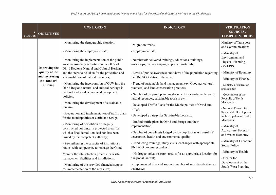
Draft Report on SEA by implementing the Management Plan for the Natural and Cultural Heritage in the Ohrid region
150 Civil Engineering Institute “Makedonija” AD Skopje
SUBJECTS
OBJECTIVES
MONITORING INDICATORS VERIFICATION SOURCES /
COMPETENT BODY
Население
Improving the quality of life
and increasing the standard
of living
- Monitoring the demographic situation; - Monitoring the employment rate; - Monitoring the implementation of the public awareness-raising activities on the OUV of Ohrid Region's Natural and Cultural Heritage and the steps to be taken for the protection and sustainable use of natural resources;
- Monitoring the incorporation of OUV into the Ohrid Region's natural and cultural heritage in national and local economic development policies;
- Monitoring the development of sustainable tourism;
- Preparation and implementation of traffic plans for the municipalities of Ohrid and Struga;
- Monitoring of demolition of illegally constructed buildings in protected areas for which a final demolition decision has been issued by the competent authority;
- Strengthening the capacity of institutions / bodies with competence to manage the Good;
Monitor the site selection process for waste management facilities and installations;
- Monitoring of the provided financial support for implementation of the measures;
- Migration trends;
- Employment rate; - Number of: delivered trainings, educations, trainings, workshops, media campaigns, printed materials; - Level of public awareness and views of the population regarding the UNESCO status of the area;
- Trend of sustainable land management (ex. Good agricultural practices) and land conservation practices;
- Number of prepared planning documents for sustainable use of natural resources, sustainable tourism etc.;
- Developed Traffic Plans for the Municipalities of Ohrid and Struga;
- Developed Strategy for Sustainable Tourism;
- Drafted traffic plans in Ohrid and Struga and their implementation;
- Number of complaints lodged by the population as a result of deteriorated health and environmental quality;
- Conducting trainings, study visits, exchanges with appropriate UNESCO governing bodies;
- Hydrogeological research results for an appropriate location for a regional landfill;
- Implemented financial support, number of subsidized citizens / businesses;
Ministry of Transport and Communications
- Ministry of Environment and Physical Planning (MoEPP)
- Ministry of Economy
- Ministry of Finance
- Ministry of Education and Science
- Government of the Republic of North Macedonia;
- National Council for Sustainable Development in the Republic of North Macedonia,
- Ministry of Agriculture, Forestry and Water Economy
- Ministry of Labor and Social Policy
- Ministry of Health
- Center for Development of the South-West Planning

Draft Report on SEA by implementing the Management Plan for the Natural and Cultural Heritage in the Ohrid region
151 Civil Engineering Institute “Makedonija” AD Skopje
- Monitoring the process of closure and remediation of non-compliant landfills;
- Monitoring the health status of the local population.
- Results of hydrogeological surveys for appropriate location;
- Health status of the population compared to the period before the implementation of the activities.
Region
- Institute of Public Health
- Employment Agency of the Republic of North Macedonia
- State Statistics Office
- Municipalities in the region
- Centers for social work
- Center for Crisis Management
- Citizens' associations, organizations, scientific institutions
Биолошка и пределска разновидност
- Protection of biodiversity
and landscape diversity
- Monitoring the process of harmonization of the legislation for dealing with the effects of the Plan in accordance with the UNESCO Operational Guide;
- Monitoring strategic planning at central and local level and aligning objectives to deal with the effects of the Plan with other sector strategies and plans;
- Monitoring the strengthening of the institutional capacities for implementation of the
-Number of adopted / amended laws and bylaws dealing with the management of the natural and cultural heritage of the Ohrid Region; - Trend of including the protection of the Ohrid region's natural and cultural heritage in different strategies and plans; - Number of prepared planning and strategic documents; - Establishment of a body for the management of Lake Ohrid and Studenchishko Blato; - Quantitative and qualitative analyzes of the groups of organisms
- Ministry of Environment and Physical Planning; - Ministry of Economy; - Ministry of Finance, - Ministry of Agriculture, Forestry and Water Economy; - Ministry of Transport and Communications;
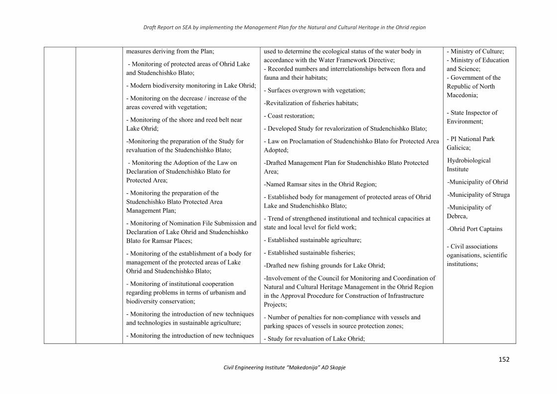
Draft Report on SEA by implementing the Management Plan for the Natural and Cultural Heritage in the Ohrid region
152 Civil Engineering Institute “Makedonija” AD Skopje
measures deriving from the Plan;
- Monitoring of protected areas of Ohrid Lake and Studenchishko Blato;
- Modern biodiversity monitoring in Lake Ohrid;
- Monitoring on the decrease / increase of the areas covered with vegetation;
- Monitoring of the shore and reed belt near Lake Ohrid;
-Monitoring the preparation of the Study for revaluation of the Studenchishko Blato;
- Monitoring the Adoption of the Law on Declaration of Studenchishko Blato for Protected Area;
- Monitoring the preparation of the Studenchishko Blato Protected Area Management Plan;
- Monitoring of Nomination File Submission and Declaration of Lake Ohrid and Studenchishko Blato for Ramsar Places;
- Monitoring of the establishment of a body for management of the protected areas of Lake Ohrid and Studenchishko Blato;
- Monitoring of institutional cooperation regarding problems in terms of urbanism and biodiversity conservation;
- Monitoring the introduction of new techniques and technologies in sustainable agriculture;
- Monitoring the introduction of new techniques
used to determine the ecological status of the water body in accordance with the Water Framework Directive; - Recorded numbers and interrelationships between flora and fauna and their habitats;
- Surfaces overgrown with vegetation;
-Revitalization of fisheries habitats;
- Coast restoration;
- Developed Study for revalorization of Studenchishko Blato;
- Law on Proclamation of Studenchishko Blato for Protected Area Adopted;
-Drafted Management Plan for Studenchishko Blato Protected Area;
-Named Ramsar sites in the Ohrid Region;
- Established body for management of protected areas of Ohrid Lake and Studenchishko Blato;
- Trend of strengthened institutional and technical capacities at state and local level for field work;
- Established sustainable agriculture;
- Established sustainable fisheries;
-Drafted new fishing grounds for Lake Ohrid;
-Involvement of the Council for Monitoring and Coordination of Natural and Cultural Heritage Management in the Ohrid Region in the Approval Procedure for Construction of Infrastructure Projects;
- Number of penalties for non-compliance with vessels and parking spaces of vessels in source protection zones;
- Study for revaluation of Lake Ohrid;
- Ministry of Culture; - Ministry of Education and Science; - Government of the Republic of North Macedonia; - State Inspector of Environment; - PI National Park Galicica;
Hydrobiological Institute
-Municipality of Ohrid
-Municipality of Struga
-Municipality of Debrca,
-Ohrid Port Captains - Civil associations oganisations, scientific institutions;
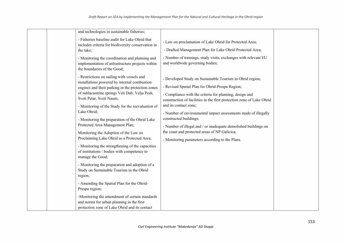
Draft Report on SEA by implementing the Management Plan for the Natural and Cultural Heritage in the Ohrid region
153 Civil Engineering Institute “Makedonija” AD Skopje
and technologies in sustainable fisheries;
- Fisheries baseline audit for Lake Ohrid that includes criteria for biodiversity conservation in the lake;
- Monitoring the coordination and planning and implementation of infrastructure projects within the boundaries of the Good;
- Restrictions on sailing with vessels and installations powered by internal combustion engines and their parking in the protection zones of sublacustrine springs Veli Dab, Velja Pesh, Sveti Petar, Sveti Naum;
- Monitoring of the Study for the reevaluation of Lake Ohrid;
- Monitoring the preparation of the Ohrid Lake Protected Area Management Plan;
Monitoring the Adoption of the Law on Proclaiming Lake Ohrid as a Protected Area;
- Monitoring the strengthening of the capacities of institutions / bodies with competence to manage the Good;
- Monitoring the preparation and adoption of a Study on Sustainable Tourism in the Ohrid region;
- Amending the Spatial Plan for the Ohrid-Prespa region;
-Monitoring the amendment of certain standards and norms for urban planning in the first protection zone of Lake Ohrid and its contact
- Law on proclamation of Lake Ohrid for Protected Area;
- Drafted Management Plan for Lake Ohrid Protected Area;
- Number of trainings, study visits, exchanges with relevant EU and worldwide governing bodies;
- Developed Study on Sustainable Tourism in Ohrid region;
- Revised Spatial Plan for Ohrid-Prespa Region;
- Compliance with the criteria for planning, design and construction of facilities in the first protection zone of Lake Ohrid and its contact zone;
- Number of environmental impact assessments made of illegally constructed buildings;
- Number of illegal and / or inadequate demolished buildings on the coast and protected areas of NP Galicica;
- Monitoring parameters according to the Plans.
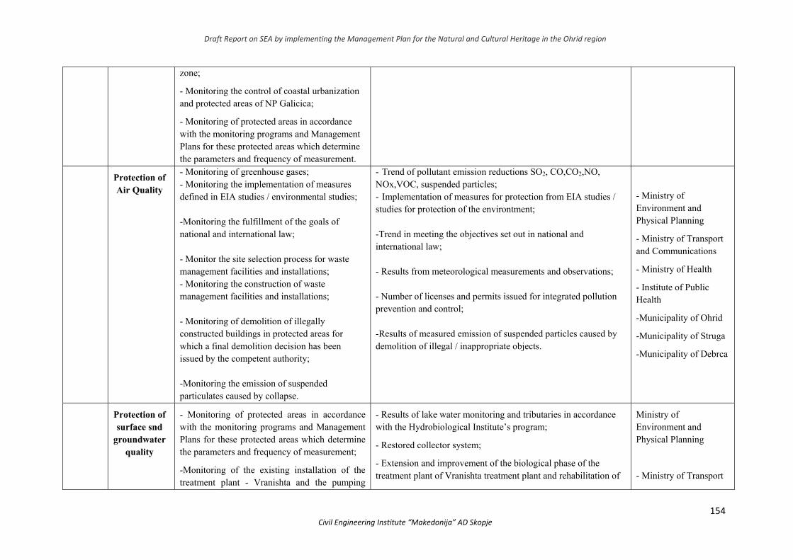
Draft Report on SEA by implementing the Management Plan for the Natural and Cultural Heritage in the Ohrid region
154 Civil Engineering Institute “Makedonija” AD Skopje
zone;
- Monitoring the control of coastal urbanization and protected areas of NP Galicica;
- Monitoring of protected areas in accordance with the monitoring programs and Management Plans for these protected areas which determine the parameters and frequency of measurement.
Воздух
Protection of Air Quality
- Monitoring of greenhouse gases; - Monitoring the implementation of measures defined in EIA studies / environmental studies; -Monitoring the fulfillment of the goals of national and international law; - Monitor the site selection process for waste management facilities and installations; - Monitoring the construction of waste management facilities and installations; - Monitoring of demolition of illegally constructed buildings in protected areas for which a final demolition decision has been issued by the competent authority; -Monitoring the emission of suspended particulates caused by collapse.
- Trend of pollutant emission reductions SO2, CO,CO2,NO, NОx,VOC, suspended particles; - Implementation of measures for protection from EIA studies / studies for protection of the environtment; -Trend in meeting the objectives set out in national and international law; - Results from meteorological measurements and observations; - Number of licenses and permits issued for integrated pollution prevention and control; -Results of measured emission of suspended particles caused by demolition of illegal / inappropriate objects.
- Ministry of Environment and Physical Planning
- Ministry of Transport and Communications
- Ministry of Health
- Institute of Public Health
-Municipality of Ohrid
-Municipality of Struga
-Municipality of Debrca
Површински и подземни води
Protection of surface snd
groundwater quality
- Monitoring of protected areas in accordance with the monitoring programs and Management Plans for these protected areas which determine the parameters and frequency of measurement;
-Monitoring of the existing installation of the treatment plant - Vranishta and the pumping
- Results of lake water monitoring and tributaries in accordance with the Hydrobiological Institute’s program;
- Restored collector system;
- Extension and improvement of the biological phase of the treatment plant of Vranishta treatment plant and rehabilitation of
Ministry of Environment and Physical Planning
- Ministry of Transport
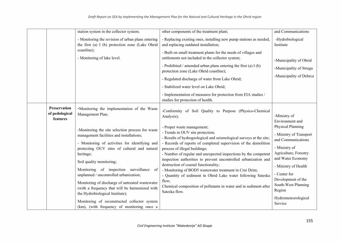
Draft Report on SEA by implementing the Management Plan for the Natural and Cultural Heritage in the Ohrid region
155 Civil Engineering Institute “Makedonija” AD Skopje
station system in the collector system;
- Monitoring the revision of urban plans entering the first (a) I (b) protection zone (Lake Ohrid coastline);
- Monitoring of lake level.
other components of the treatment plant;
- Replacing existing ones, installing new pump stations as needed, and replacing outdated installation;
- Built on small treatment plants for the needs of villages and settlements not included in the collector system;
- Prohibited / amended urban plans entering the first (a) I (b) protection zone (Lake Ohrid coastline);
- Regulated discharge of water from Lake Ohrid;
- Stabilized water level on Lake Ohrid;
- Implementation of measures for protection from EIA studies / studies for protection of health.
and Communications
-Hydrobiological Institute
-Municipality of Ohrid
-Municipality of Struga
-Municipality of Debrca
Почва Preservation of pedological
features
-Monitoring the implementation of the Waste Management Plan;
-Monitoring the site selection process for waste management facilities and installations;
- Monitoring of activities for identifying and protecting OUV sites of cultural and natural heritage;
Soil quality monitoring;
Monitoring of inspection surveillance of unplanned / uncontrolled urbanization;
Monitoring of discharge of untreated wastewater (with a frequency that will be harmonized with the Hydrobiological Institute);
Monitoring of reconstructed collector system (km), (with frequency of monitoring once a
-Conformity of Soil Quality to Purpose (Physico-Chemical Analysis); - Proper waste management; - Trends in OUV site protection; - Results of hydrogeological and seismological surveys at the site; - Records of reports of completed supervision of the demolition process of illegal buildings; - Number of regular and unexpected inspections by the competent inspection authorities to prevent uncontrolled urbanization and destruction of coastal functionality; - Monitoring of BOD5 wastewater treatment in Crni Drim; - Quantity of sediment in Ohrid Lake water following Sateska flow; Chemical composition of pollutants in water and in sediment after Sateska flow.
-Ministry of Environment and Physical Planning
- Ministry of Transport and Communications
- Ministry of Agriculture, Forestry and Water Economy
- Ministry of Health
- Center for Development of the South-West Planning Region
Hydrometeorological Service
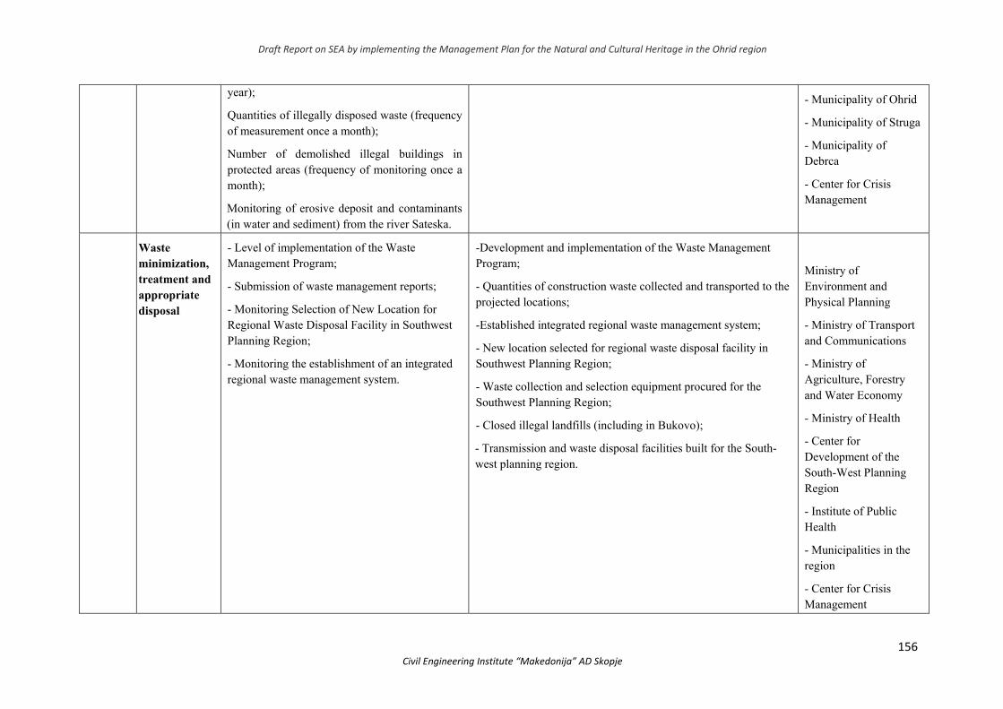
Draft Report on SEA by implementing the Management Plan for the Natural and Cultural Heritage in the Ohrid region
156 Civil Engineering Institute “Makedonija” AD Skopje
year);
Quantities of illegally disposed waste (frequency of measurement once a month);
Number of demolished illegal buildings in protected areas (frequency of monitoring once a month);
Monitoring of erosive deposit and contaminants (in water and sediment) from the river Sateska.
- Municipality of Ohrid
- Municipality of Struga
- Municipality of Debrca
- Center for Crisis Management
Отпад Waste minimization, treatment and appropriate disposal
- Level of implementation of the Waste Management Program;
- Submission of waste management reports;
- Monitoring Selection of New Location for Regional Waste Disposal Facility in Southwest Planning Region;
- Monitoring the establishment of an integrated regional waste management system.
-Development and implementation of the Waste Management Program;
- Quantities of construction waste collected and transported to the projected locations;
-Established integrated regional waste management system;
- New location selected for regional waste disposal facility in Southwest Planning Region;
- Waste collection and selection equipment procured for the Southwest Planning Region;
- Closed illegal landfills (including in Bukovo);
- Transmission and waste disposal facilities built for the South-west planning region.
Ministry of Environment and Physical Planning
- Ministry of Transport and Communications
- Ministry of Agriculture, Forestry and Water Economy
- Ministry of Health
- Center for Development of the South-West Planning Region
- Institute of Public Health
- Municipalities in the region
- Center for Crisis Management
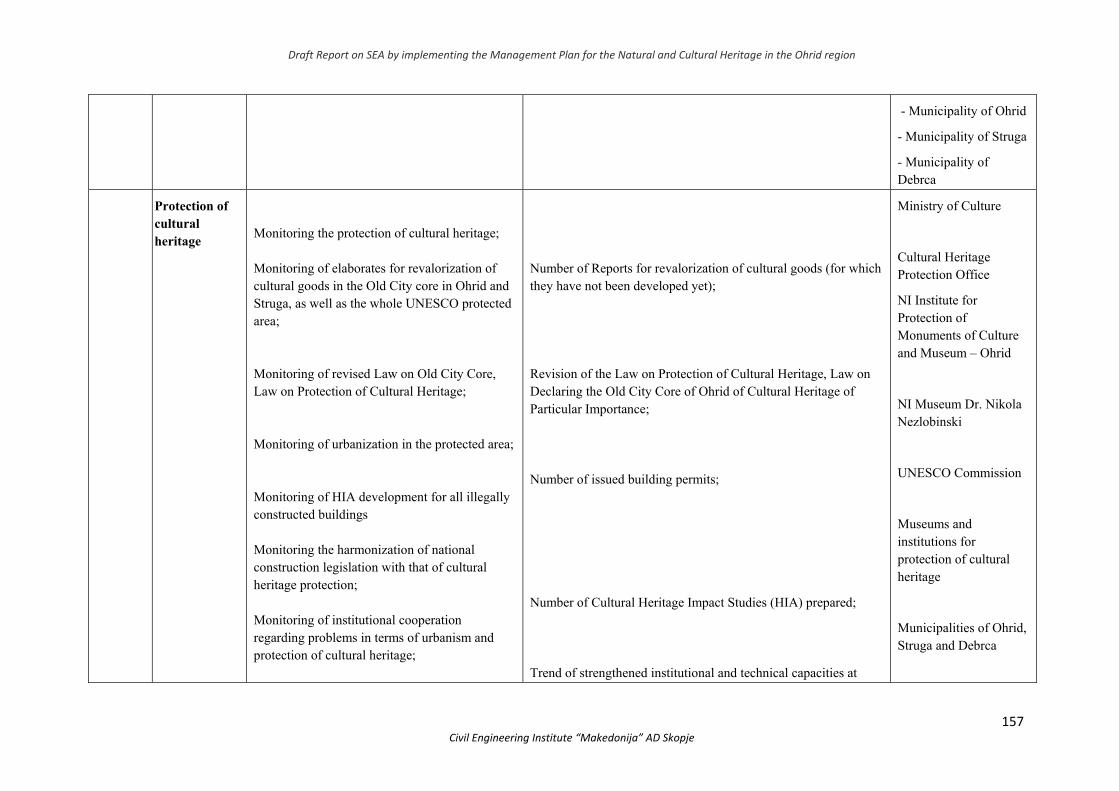
Draft Report on SEA by implementing the Management Plan for the Natural and Cultural Heritage in the Ohrid region
157 Civil Engineering Institute “Makedonija” AD Skopje
- Municipality of Ohrid
- Municipality of Struga
- Municipality of Debrca
Protection of cultural heritage
Monitoring the protection of cultural heritage; Monitoring of elaborates for revalorization of cultural goods in the Old City core in Ohrid and Struga, as well as the whole UNESCO protected area; Monitoring of revised Law on Old City Core, Law on Protection of Cultural Heritage; Monitoring of urbanization in the protected area; Monitoring of HIA development for all illegally constructed buildings Monitoring the harmonization of national construction legislation with that of cultural heritage protection; Monitoring of institutional cooperation regarding problems in terms of urbanism and protection of cultural heritage;
Number of Reports for revalorization of cultural goods (for which they have not been developed yet); Revision of the Law on Protection of Cultural Heritage, Law on Declaring the Old City Core of Ohrid of Cultural Heritage of Particular Importance; Number of issued building permits; Number of Cultural Heritage Impact Studies (HIA) prepared; Trend of strengthened institutional and technical capacities at
Ministry of Culture
Cultural Heritage Protection Office
NI Institute for Protection of Monuments of Culture and Museum – Ohrid
NI Museum Dr. Nikola Nezlobinski
UNESCO Commission
Museums and institutions for protection of cultural heritage
Municipalities of Ohrid, Struga and Debrca
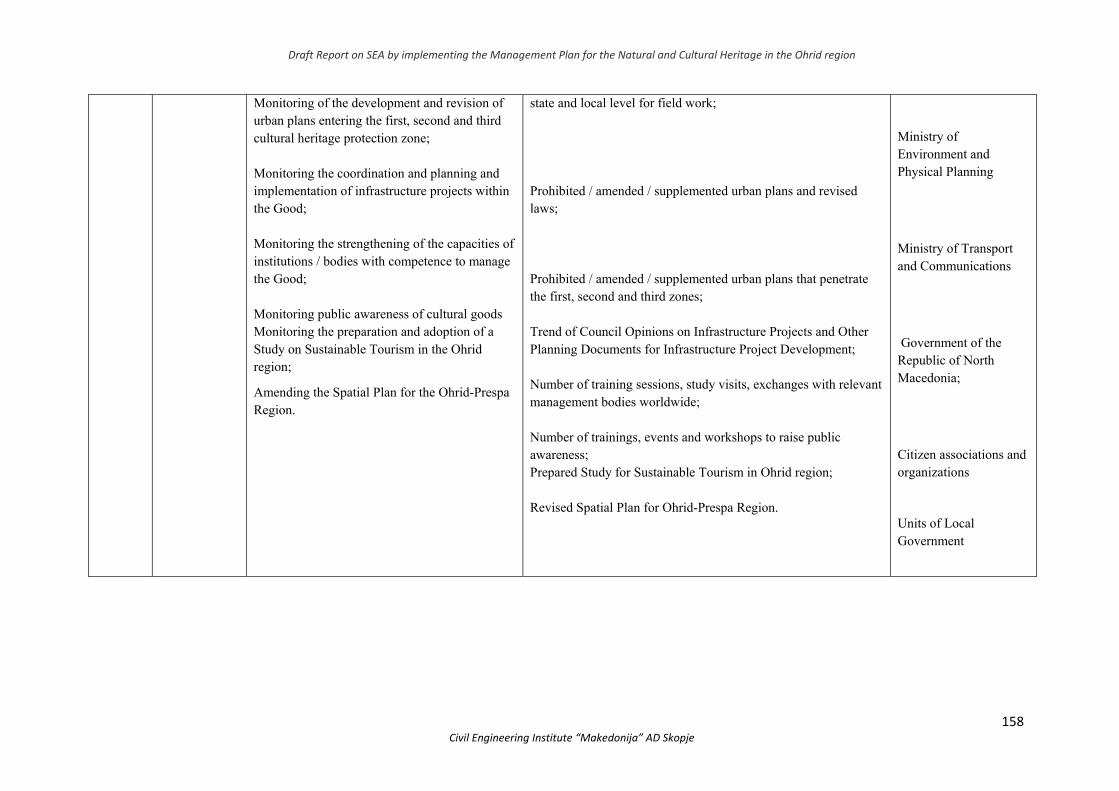
Draft Report on SEA by implementing the Management Plan for the Natural and Cultural Heritage in the Ohrid region
158 Civil Engineering Institute “Makedonija” AD Skopje
Monitoring of the development and revision of urban plans entering the first, second and third cultural heritage protection zone; Monitoring the coordination and planning and implementation of infrastructure projects within the Good; Monitoring the strengthening of the capacities of institutions / bodies with competence to manage the Good; Monitoring public awareness of cultural goods Monitoring the preparation and adoption of a Study on Sustainable Tourism in the Ohrid region;
Amending the Spatial Plan for the Ohrid-Prespa Region.
state and local level for field work; Prohibited / amended / supplemented urban plans and revised laws; Prohibited / amended / supplemented urban plans that penetrate the first, second and third zones; Trend of Council Opinions on Infrastructure Projects and Other Planning Documents for Infrastructure Project Development; Number of training sessions, study visits, exchanges with relevant management bodies worldwide; Number of trainings, events and workshops to raise public awareness; Prepared Study for Sustainable Tourism in Ohrid region; Revised Spatial Plan for Ohrid-Prespa Region.
Ministry of Environment and Physical Planning
Ministry of Transport and Communications
Government of the Republic of North Macedonia;
Citizen associations and organizations
Units of Local Government
Draft Report on SEA by implementing the Management Plan for the Natural and Cultural Heritage in the Ohrid region
159 Civil Engineering Institute “Makedonija” AD Skopje
10. NON-TECHNICAL SUMMARY
The Strategic Environemental Assessment (SEA) is a systematic and participatory process implemented so as to analyse the impact on the environment, human life and health as well as the social and economic aspects regarding the implementation of a specific planning document in this case “Management Plan for the Natural and Cultural Heritage of the Ohrid Region” (hereinafter referred to as: The plan).
The SEA procedure integrates environmental issues when making decisions on the scope and methods of ithe implementation of the plan. In doing so, the authorities (The Ministry of Culture and The Ministry of Environment and Physical Planning) responsible for implementing the plan, shall, in its review and finalization, take the following into account:
States and trends of environmental areas and activities that may have an impact or be affected by the implementation of the Plan;
Environmental objectives and indicators of their achievement in the implementation of the Plan;
Possible significant environmental effects that may result from the implementation of the Plan;
Measures to avoid, reduce or mitigate the negative impact;
Views, needs and information provided by stakeholders (including competent authorities), in the country and in the coross-border context.
The Strategic Environmental Assessment in accordance with the Law on Environment
("Official Gazette of the Republic of Macedonia" No. 53/05, 81/05, 24/07, 159/08, 83/09, 48/10, 124/10 , 51/11, 123/12, 93/13, 187/13, 42/14, 44/15, 129/15, 192/15, 39/16 and 99/18) are being prepared simultaneously with the revision of the Plan. These two processes will allow for the proper incorporation of environmental protection objectives and mitigation measures into the Ohrid Region Outstanding Universal Value (OUV) wihtin the framework of the Plan.
The whole SEA process, led through direct cooperation with the Plan Holders, leads to better environmental protection and management (with a particular emphasis on natural and cultural heritage) and promotes sustainable development in the Ohrid Region, as well as stimulation of the public consultation process and stakeholders. It also strengthens the process of policy-making, planning and decision-making, thereby providing a number of immediate and long-term benefits to decision makers such as local government, authorities, public institutions, etc. The procedural benefits of SEA include the efficiency of planning processes and improved management in the Ohrid Region.
The process of developing the Plan is based on the concept of teamwork and the interdisciplinary approach, which implies synchronized management of multiple research procedures by a team of experts from different specialties, based on a common methodological platform, goals to be achieved and the unified coordination. During the preparation of the Plan, extensive stakeholder consultation was conducted. Competent institutions and organizations from Albania are also involved in the process to ensure synergy
Draft Report on SEA by implementing the Management Plan for the Natural and Cultural Heritage in the Ohrid region
160 Civil Engineering Institute “Makedonija” AD Skopje
between the National Plans for Natural and Cultural Heritage Management in the Ohrid region.
Comparative analyzes and experiences from other countries that have already
prepared World Heritage Management Plans, as well as recommendations from UNESCO experts and its advisory bodies, have been used in the development of the Management Plan.
Topics covered in the Plan are as follows:
13. Introduction: History of the Ohrid Region, Outstanding Universal Value, Inclusion Criteria of the Ohrid Region in the World Heritage List;
14. Values of the region (natural, cultural, social, scientific and educational), integrity and authenticity and boundaries of the World Heritage in the Ohrid region;
15. Methodology and process of preparation of the Management Plan for the natural and cultural heritage in the Ohrid region;
16. Management of the World heritage in the Ohgid region; 17. Risks and threat assessment of outstanding universal values 18. Vision and goals of protection 19. Zoning and protection of the borders of the natural and cultural heritage in the Ohrid
region 20. Action Plan 21. Monitoring Plan 22. Visit Management Plan 23. Education Program 24. Attachments The plan envisages targeting the future spatial development of the Ohrid Region for OUV
protection. Thereby, zoning is performed with defined measures for protection of the natural and cultural heritage. The application of the value system and the establishment of relationships between ecological, social and economic balance have defined zoning criteria for both natural and cultural heritage.
For each of the envisaged natural heritage protection zones, the Plan provides appropriate protection regimes, detailing prohibited activities that should be regulated by an appropriate legal act.
Taking into consideration the complexity and diversity of the cultural heritage, and in order to adequately protect the cultural heritage, the sustainable development and the controlled urbanization, several protection zones have been defined in the Ohrid region with their specific conditions and measures for preserving the following characteristics: City urban centres, Religious Heritage, Coastal and Rural Settlements and Archaeological Sites.
The Plan includes the Report of the Reactive Monitoring Mission which outlines the risks and threats to the outstanding universal value of the world natural and cultural heritage in the Ohrid region. In addition, the SEA has carried out a risk assessment in accordance with the guidelines published by IUCN and GIWA. The classification recommended by the IUCN addresses risks to endangered species of flora and fauna, while the risks identified by GIWA apply an ecosystem approach. Impacts / risks on the Lake may include quality disturbances, changes in hydrology, habitat loss and biodiversity, etc. These

Draft Report on SEA by implementing the Management Plan for the Natural and Cultural Heritage in the Ohrid region
161 Civil Engineering Institute “Makedonija” AD Skopje
effects may also reflect the economic and social aspects. It is particularly important to note that these risks and effects are present on both sides of the lake (Albania and North Macedonia).
The urbanization of the Ohrid region began in the middle of the 20th century, and the urbanization of new parts of towns and tourist complexes in the coastal part of the lake is particularly intense; historic nuclei with more or less changes remain in their historical context and the existing cultural landscape.
Excessive and uncontrolled urbanization adversely affects the preservation of: the structure of the old city cores of Ohrid and Struga with the old city architecture, the structure of coastal settlements, and other areas where cultural goods are found.
Cumulative impact analysis of the railway and highway is one of the recommendations of UNESCO. In addition to this SEA report, the cumulative impacts of the pipeline and transmission line planned within the UNESCO area are also analyzed. Unlike EIA studies (as developed for each project separately, except for the pipeline) where impacts are expected from individual projects, the SEA focuses on what is expected as impact on the landscape or regional level, i.e. how all linear infrastructure projects would fit in the region. That is why the cumulative impacts in this SEA are considered regionally and as the impact of landscape values.
Chapter 3 provides basic information on the Region as well as the state of the environment. Special emphasis is given to environmental features in areas that would be significantly affected and condition without plan implementation such as OUV sites of natural and cultural heritage. Areas of particular importance to the environment in terms of the conservation of wild birds and habitats have also been analyzed
The scope of the SEA has been also determined by setting the goals and
challenges of the Plan and the SEA, as well as testing their correlation. The preservation of the outstanding universal values of the Ohrid region's natural and cultural heritage presents a number of challenges. By analyzing UNESCO Reports, public opinion and that of the stakeholders, such as expert opinion, as main challenges identified in all of the above documents are the uncontrolled urbanization, insufficiently functioning system of natural and cultural heritage management, non-implementation of legal and institutional framework, exploitation of natural resources; coastal and landscape urban transformation and the cumulative impact of infrastructure facilities, underdeveloped local awareness and institutional capacity for OUV, disruption of the coastal functionality index. The response to these development challenges should be prioritized and a plan for their implementation should prepared).
That is where the objectives of the SEA were set - based on relevant national and EU laws, strategies and plans. The purpose of this SEA is to ensure that environmental protection, especially the OUV of the Ohrid region, is in line with the Management Plan and the legal framework. This will be done through a timely assessment of the impacts that the OUV problems may have and the alternatives to avoid or reduce them. The timely inclusion of
Draft Report on SEA by implementing the Management Plan for the Natural and Cultural Heritage in the Ohrid region
162 Civil Engineering Institute “Makedonija” AD Skopje
OUV protection goals will enable the sustainable development of the Ohrid Region and the preservation of the natural and cultural heritage for which it is under UNESCO protection
The SEA focuses on impacts that cannot be easily resolved at the project level (as in the case of cumulative impacts), i.e. problems that need to be addressed at strategic level. For this purpose, key issues to be assessed were identified, drawn up on the basis of UNESCO recommendations, issues raised by the institutions concerned, and issues of concern to the public and non-governmental sector, as well as the expert findings of the SEA study team.
Given the fact that it is a complex system encompassing nature conservation and cultural heritage, it interacts with many other planning documents, programs and strategies. Therefore, the potential existence of direct and indirect links between the plan in question and other planning documents at local, regional, national and/or international level, their compatibility and compliance within the strategic environmental assessment procedure needs to be analyzed. This type of analysis should determine whether there is a potential conflict of compliance between the objectives of the various planning documents, and if this appears to be the case, it is necessary that compatibility measures are defined. For the purposes of analyzing the links and compatibility between the Management Plan for the Ohrid Region’s Heritage 2019-2028 and other planning documents, several planning documents at local, regional and national level from the following key areas have been analyzed in the context of the SEA procedure in the plan: a) Management of protected areas; b) Environmental protection; c) Economic development; d) Sustainable development, e) Relevant areas - tourism, energy, transport, social policy.
The synchronization of the considered planning document with other existing plans, programs and strategies will prospectively enable its realization, and in addition to achieving the direct objectives of the plan, more or less contribute to the realization of the objectives of the other plans. The continued application of such an approach, within the SEA, provides a systematic solution for achieving a high degree of complementarity with the objectives of individual planning documents and optimizing efficiency in their achievement, regardless of their hierarchical or other type of relationship.
The planning document is prepared in accordance with all the adopted domestic legislation, EU legislation, as well as international documents ratified in the Republic of North Macedonia.
The legal framework for the SEA requires "to state the reasons for choosing an alternative solution". In the case of this SEA of the Natural and Cultural Heritage Management Plan the following alternatives were considered:
'No change' scenario: this assumes that the management plan is not adopted. Alternative Management Approaches: Here are summarized alternative management
responses to include the proposed infrastructure projects. This section provides an overview of the additional alternatives considered by Investors of planned development projects identified by the SEA in order to avoid and/or minimize any potential significant residual impacts.
Alternative Contact Zone Solutions.

Draft Report on SEA by implementing the Management Plan for the Natural and Cultural Heritage in the Ohrid region
163 Civil Engineering Institute “Makedonija” AD Skopje
Although the SEA provides an overview of alternative solutions to infrastructure projects, it does not provide a detailed analysis of alternative solutions by several criteria. This should be an EIA study task at the project level. The key strategic issues at which project-level alternative solutions differ are highlighted within the SEA
The next chapter identifies the potential positive and negative impacts of the implementation of the Action Plan. The Strategic Assessment Report takes into account the impacts on water, air, soil, biodiversity, landscapes and their landscape values, natural and cultural heritage, as well as the impacts on the socio-economic situation and human health in the Ohrid Region (municipalities of Ohrid, Struga and Debrca). Generally, the implementation of planning solutions is aimed at having a positive impact on the environment and social aspects.
It should also be noted that the Strategic Assessment Report does not include a detailed analysis of individual development projects, but rather analyzes the impacts on the media and the environment in a broader context. The Report assesses the potential environmental impacts and socio-economic aspects, while, at a later stage, through Environmental Impact Assessment Studies or Environmental Impact Assessments, which arise as a legal obligation on the basis of the potential identified. Negative impacts make detailed analyzes and recommendations.
Pursuant to the Law on Environment and the Decree on Criteriа Determination, on the basis of which the need for conducting an environmental impact assessment procedure is determined, it is necessary to determine the need for conducting an environmental impact assessment procedure. The need of the Environmental Impact Assessment shall be adopted by the body of the state administration responsible for the affairs of the environment. Pursuant to the Law on Environment, as well as the Law on Nature Protection, legal entities or natural persons that perform activities which are not part of the projects for which an environmental impact assessment procedure is carried out, are obliged to prepare an Environmental Impact Assessment Report in order to assess the impact of the activities on the environment, before commencing the implementation of the project and forwarding it to the body responsible for approving the implementation of the project.
While analyzing the impacts, special attention will be paid to the impacts on the protected
World Heritage, especially Lake Ohrid. During the evaluation, stakeholders were consulted on this protected area.
If the implementation of some of the measures and activities arising from the Plan were not addressed properly and with a pre-set dynamic, additional negative impacts on the media and environmental areas would be expected. Part of the Action Plan expected to impact the environment is:
4. Reconstruction of the collector and sewage networks in the settlements along Lake Ohrid and the wastewater treatment plant,
5. Construction of Waste Transfer and Waste Disposal Plants for the South-west Planning Region,
6. Demolition of illegal buildings in protected areas for which a final demolition decision has been issued by the competent authority.
Key impacts are likely to relate to:
Draft Report on SEA by implementing the Management Plan for the Natural and Cultural Heritage in the Ohrid region
164 Civil Engineering Institute “Makedonija” AD Skopje
Risk of pollution and sedimentation of Lake Ohrid during construction works (especially demolition on the coast);
Emissions to air and noise during the construction phase which may cause consequences for flora and fauna;
Impacts on cultural heritage due to construction activities especially in the old city core;
Discomfort from air emissions and noise during the construction phase for the local population.
Planned actions such as demolition and reconstruction of buildings in the coastal zone can lead to deterioration of hydrology, lake water quality, biodiversity, landscape values and adversely affect the preservation of: old city architecture, coastal structure, structure of the old town nuclei of Ohrid and Struga and the surrounding areas with historical monuments.
A detailed analysis of the type of impacts at all stages of the project should be undertaken for each of the Actions individually. All project phases such as facility construction, demolition, operational phase, case of sudden emergency and in case of project termination should be analyzed in terms of impact of all project activities on all environmental elements in EIA studies or elaborates (as previously stated).
Two of the identified impacts have so far been subject to an environmental impact assessment:
Impacts that would result from the reconstruction of the collector system are elaborated in the Lake Ohrid Environmental Data Collection Study and Collector System Rehabilitation Techniques, DZAJKA (originally: “ЏАЈКА”), 2015.
Impact analysis that would result from the construction of the Waste Transmission and Disposal Facility for the South-West Planning Region was carried out in the context of the SEA and EIA Regional Waste Management Plan for the South-West Region.
For the demolition of illegal buildings in protected areas for which an Effective Demolition Decision has been issued by the competent authority, it is necessary to prepare an Elaborate for Demolition of Illegal Buildings in accordance with the Law on Construction and Separate Environmental Impact Assessment and Heritage Impact Assessment. Based on previously known information, the environmental risks of these activities are unlikely to be significant and long-lasting and may be mitigated by typical construction control measures.
The Impact Analysis showed that the implementation of the measures and activities contained in the Action Plan will contribute to the sustainable management of good in the Ohrid region. Each of the activities is aimed at reducing the existing problems affecting the media and areas in the, so the impacts of the Plan are considered to be positive and their implementation will achieve conservation of the natural heritage and sustainable development of the area, such as and meeting environmental objectives. It should be noted that many of the measures provide guidance for the preparation and/or modification of the legal framework, strategies, plans, programs and projects. Some of them are of a regulatory nature, and part of
Draft Report on SEA by implementing the Management Plan for the Natural and Cultural Heritage in the Ohrid region
165 Civil Engineering Institute “Makedonija” AD Skopje
them is the realization of specific projects, which will additionally be subject to a procedure for more detailed environmental impact assessment.
From the above-mentioned impacts that cover construction activities in general, good designing practice and organization of construction sites can minimize much of the impacts identified for the construction phase. Also, environmental management methods will greatly mitigate the impacts identified for the operational phase.
What is particularly important and the purpose of strategic planning is to provide control over the implementation of the measures and activities of the Plan in line with the competent institutions, local governments, public enterprises and the private sector. For this purpose it is necessary:
Preparation of Information to the Government of the Republic of North Macedonia with a detailed analysis of the legal obligations stemming from signed national and international agreements in all sectoral policies and their alignment, with financial implications, to avoid collisions/contradictions,
Ensuring cooperation and coordination with relevant ministries and institutions in order to achieve compliance of the measures resulting from the Plan in the sectoral strategic and planning documents and activities covering the same timeframe, but even more so in future sectoral strategies and plans,
Extensive intersectoral cooperation, discussion and alignment.
The purpose of the Environmental Monitoring Plan is to monitor the effects of the implementation of the planning document on the environmental media.
The plan should make it possible to see the newly foreseen effects and to take appropriate action to improve the situation. In case of perceived negative effects of the implementation of the planning document, the body preparing the planning document as well as other legal entity or natural person and environmental associations shall be obliged to notify the state administrative body responsible for the affairs of the environment.
The main objectives and benefits of environmental impact monitoring are: - monitoring the implementation of the activities foreseen in the planning document; - monitoring the implementation of impact control measures; - provide data for further monitoring of environmental conditions; - monitoring the state of the environment in order to timely identify the unforeseen
impacts of the implementation of the Plan and their management; - confirming that the application of mitigation measures increases the benefits of
environmental protection; - identifying what actions should be taken to reduce environmental impacts. In order to monitor the effectiveness of the planning document it is necessary to monitor
the set indicators and their development to confirm the objectives of the Project. Monitoring of indicators requires taking into account the data on the current state of the environment.
The monitoring of the state of the environment confirms the justification and application of the proposed mitigation measures and their functionality, which is a major environmental benefit.

Draft Report on SEA by implementing the Management Plan for the Natural and Cultural Heritage in the Ohrid region
166 Civil Engineering Institute “Makedonija” AD Skopje
8. PUBLIC INSTITUTIONS REPORT


![BIODIVERSITY IN OHRID AND PRESPA [Read-Only] · 2016. 5. 26. · Lake Ohrid has specific and unique Salmonidae ichthyofauna OHRID PRESPA Lake Ohridis a unique aquatic ecosystem and](https://img.pdfslide.net/doc/110x75/60c4abb827e9ed4cf25f0960/biodiversity-in-ohrid-and-prespa-read-only-2016-5-26-lake-ohrid-has-specific.jpg)