Embed Size (px)
Citation preview

NAMEDATE
The Unit Organizer BIGGER PICTURE
LAST UNIT /Experience NEXT UNIT /Experience
UN
IT S
ELF-
TEST
Q
UES
TIO
NS
is about...
UN
IT RELA
TION
SHIPS
UNIT SCHEDULE UNIT MAP
CURRENT UNIT1 3 2
4
5
6
7
8
understanding how Earth’s
surface changes
tectonic plate plate tectonics crustal feature sea floor spreading plate boundary divergent convergent transform subduction rift valley mid-ocean ridge topographic map satellite view land features erosional feature contour line contour interval altitude elevation depressionsteep slope continental drift Alfred Wegener Harry Hess weathering erosion deposition
investigating development of
interpreting
modeling &
mapping
predicting
IMPORTANT TERMS:
The Theory of Plate
Tectonics
The Theory of Plate
Tectonics
plate boundaries
plate boundaries
reshaping of Earth’s surface reshaping of
Earth’s surface formation of
crustal features
formation of crustal
features
explaining
What evidence was developed to support the theory of plate tectonics?How did human understanding of Earth’s crust change with plate tectonic theory?What crustal features form at each type of plate boundary?How are contour lines used to show land features on a topographic map?What do satellite views reveal about Earth’s surface and land features?How can weathering, erosion, and deposition reshape land features?
InvestigatingDescribing
InterpretingComparingAnalyzingPredicting
Unit 7 Assessment: Forces that change the Earth
Physics
topographic & satellite
maps
topographic & satellite
maps
Dec 1: Launch UO
Dec 2: FRAME: Plate Tectonic Theory
Dec 3: Time Line
Dec 4-8: FRAME: Earth’s Features (3days: one for each boundary type/PBL)
Dec 9: LAB: Mapping Mt. Capulin
Dec 10: Google Earth(computer activity)
Dec 11: Tie Up UO
Dec 12: Unit 7 Assessment: Forces that Change the Earth
Global Patterns

Am I able to ___?
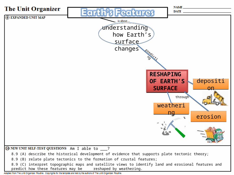
8.9 (A) describe the historical development of evidence that supports plate tectonic theory;
PLATE TECTONIC THEORY
PLATE TECTONIC THEORY
puzzle-fit of continents
puzzle-fit of continents
fossilsfossilsrock layers
& glacial deposits
rock layers & glacial deposits
seismic & volcanic activity
seismic & volcanic activity
evidenced by understanding
how Earth’s surface changes
sea floor spreadingsea floor
spreading
by describing
OPENOPEN

WHAT EVIDENCE WAS DEVELOPED TO SUPPORT THE THEORY OF PLATE TECTONICS?
HOW DID HUMAN UNDERSTANDING OF EARTH’S CRUST CHANGE WITH PLATE TECTONIC THEORY?
The evidence that supports the Theory of Plate Tectonics is…
Today, humans understand that the Earth’s Crust changes slowly over time because…

Am I able to ___?8.9 (A) describe the historical development of evidence that supports plate tectonic theory;
8.9 (B) relate plate tectonics to the formation of crustal features;
mod
elin
g &
m
appi
ng
PLATE BOUNDARIES
PLATE BOUNDARIES
divergentdivergent
convergentconvergent
transformtransform
understanding how Earth’s surface
changes
categorized as

Am I able to ___?8.9 (A) describe the historical development of evidence that supports plate tectonic theory;
8.9 (B) relate plate tectonics to the formation of crustal features;
FORMATION OF CRUSTAL FEATURES
FORMATION OF CRUSTAL FEATURES
expl
aini
ng
mid-ocean ridgesRift Valley
mid-ocean ridgesRift Valley
Mountains,Trench w Volcanoes, or
Trench w Volcanic islands
Mountains,Trench w Volcanoes, or
Trench w Volcanic islands
fault zonesfault zones
such as
understanding how Earth’s surface
changes
OPENOPENm
odel
ing
&
map
ping
PLATE BOUNDARIES
PLATE BOUNDARIES
divergentdivergent
convergentconvergent
transformtransform
categorized as

WHAT CRUSTAL FEATURES FORM AT EACH TYPE OF PLATE BOUNDARY?
A divergent boundary will form…
A convergent boundary will form…
USE VOCABULARY:sea floor spreading subduction zone rift valley mid-ocean ridge trench volcanoes volcanic islands mountains

USE VOCABULARY:Youngest Ocean floorOldest Ocean floorConvergent BoundaryDivergent BoundaryTransform BoundarySea LevelSubductionSeafloor Spreading
Am I able to ___?8.9 (A) describe the historical development of evidence that supports plate tectonic theory;
8.9 (B) relate plate tectonics to the formation of crustal features;
8.9 (C) interpret topographic maps and satellite views to identify land and erosional features and predict how these features may be reshaped by weathering.
predicting
RESHAPING OF EARTH’S SURFACE
RESHAPING OF EARTH’S SURFACE
weatheringweatheringerosionerosion
depositiondeposition
through
understanding how Earth’s surface
changes

Am I able to ___?8.9 (A) describe the historical development of evidence that supports plate tectonic theory;
8.9 (B) relate plate tectonics to the formation of crustal features;
8.9 (C) interpret topographic maps and satellite views to identify land and erosional features and predict how these features may be reshaped by weathering.
interpreting
SATELLITE VIEWS
SATELLITE VIEWS
TOPOGRAPHIC MAPS
TOPOGRAPHIC MAPS
understanding how Earth’s surface
changes
Am I able to ___?8.9 (A) describe the historical development of evidence that supports plate tectonic theory;
8.9 (B) relate plate tectonics to the formation of crustal features;
8.9 (C) interpret topographic maps and satellite views to identify land and erosional features and predict how these features may be reshaped by weathering.
interpreting
mod
elin
g &
m
appi
ng
predicting
PLATE TECTONIC THEORY
PLATE TECTONIC THEORY
PLATE BOUNDARIES
PLATE BOUNDARIES
RESHAPING OF EARTH’S SURFACE
RESHAPING OF EARTH’S SURFACE
SATELLITE VIEWS
SATELLITE VIEWS
FORMATION OF CRUSTAL FEATURES
FORMATION OF CRUSTAL FEATURES
expl
aini
ng
weatheringweatheringerosionerosion
depositiondeposition
through
TOPOGRAPHIC MAPS
TOPOGRAPHIC MAPS
divergentdivergent
convergentconvergent
transformtransform
mid-ocean ridgesmid-ocean ridges
mountainsmountains
fault zonesfault zones
such as
puzzle-fit of continents
puzzle-fit of continents
fossilsfossilsrock layers
& glacial deposits
rock layers & glacial deposits
seismic & volcanic activity
seismic & volcanic activity
evidenced by understanding
how Earth’s surface changes
sea floor spreadingsea floor
spreading
categorized as
mid-ocean ridgesRift Valley
mid-ocean ridgesRift Valley
Mountains,Trench w Volcanoes, or
Trench w Volcanic islands
Mountains,Trench w Volcanoes, or
Trench w Volcanic islands
by describing

NAMEDATE
The Unit Organizer BIGGER PICTURE
LAST UNIT /Experience NEXT UNIT /Experience
UN
IT S
ELF-
TEST
Q
UES
TIO
NS
is about...
UN
IT RELA
TION
SHIPS
UNIT SCHEDULE UNIT MAP
CURRENT UNIT1 3 2
4
5
6
7
8
investigating development of
interpreting
modeling &
mapping
predictingexp
laining
What evidence was developed to support the theory of plate tectonics?How did human understanding of Earth’s crust change with plate tectonic theory?What crustal features form at each type of plate boundary?How are contour lines used to show land features on a topographic map?What do satellite views reveal about Earth’s surface and land features?How can weathering, erosion, and deposition reshape land features?
InvestigatingDescribing
InterpretingComparingAnalyzingPredicting
The Earth’s surface is always changing – gradually and at times violently – and this greatly impacts where and how we live and find resources.
Physics
Unit Pretest
Piecing Together Pangaea
LAB: Sea Floor Spreading
History of the Theory
More Convection Demos!
LAB: Mapping Boundaries
Modeling Boundaries
Topographic Maps &
Using Satellite Images
LAB: Mapping Mt. Capulin
Stream Table Demos
Virtual Labs
Unit Test12/ 12 EOU Assessment

Am I able to ___?8.9 (A) describe the historical development of evidence that supports plate tectonic theory;
8.9 (B) relate plate tectonics to the formation of crustal features;
8.9 (C) interpret topographic maps and satellite views to identify land and erosional features and predict how these features may be reshaped by weathering.
by describing interpreting
mod
elin
g &
m
appi
ng
predicting
PLATE TECTONIC THEORY
PLATE TECTONIC THEORY
PLATE BOUNDARIES
PLATE BOUNDARIES
RESHAPING OF EARTH’S SURFACE
RESHAPING OF EARTH’S SURFACE
FORMATION OF CRUSTAL FEATURES
FORMATION OF CRUSTAL FEATURES
expl
aini
ng
throughsuch as
evidenced by
understanding how Earth’s surface
changes
categorized as