Embed Size (px)
Citation preview
¸
¸
¸
¸
¸
!¤
!¤
!¤
!¤!¤
!¤
!¤
¸
¸
¸
¸
¸
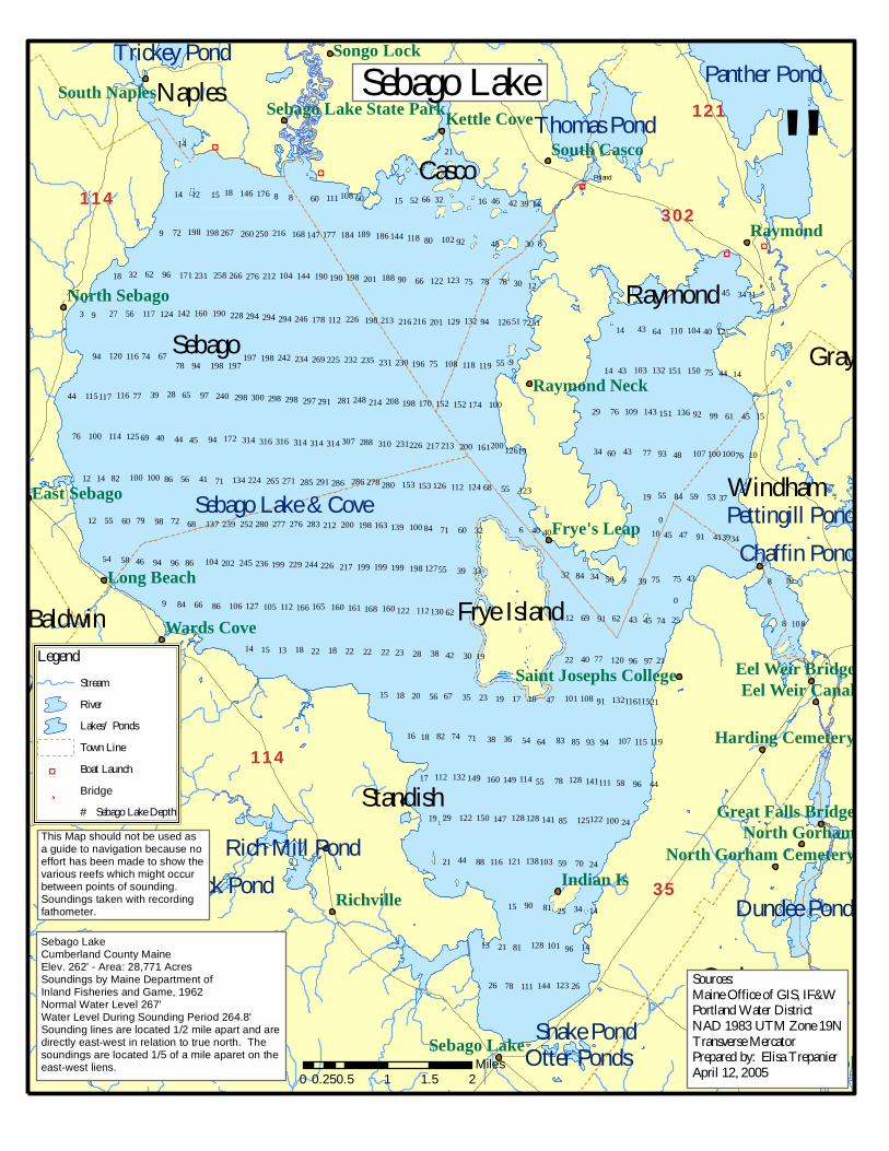
Sebago Lake & Cove
Panther PondThomas Pond
Dundee Pond
Rich Mill Pond
Trickey Pond
Little Watchie Pond
Pettingill Pond
Adams Pond
Otter Ponds
Duck Pond
Snake Pond
Chaffin Pond
Standish
SebagoRaymond
Casco
Gorham
Windham
Naples
Frye IslandBaldwin
Gray
35
121
114
114 302
9
3 9
9
88
6
9
8
09
0
88
896944658
7298796055
54
12
12 14 82 86
76 69 40
28397744
677494
27 56
18 32 62 96
72
222222 1818131514
866684
86
68
56 41 71
44 45 94
606018151214
14
9765
9478
7826
96812113
15 90 81 25
59884421
852919
785517
83645436387174821816
4710171923356756201815
2219304238282322
1262
32
4040
333955
32607184
68
19
55
32665215
21
5575
94 51
90 66 75 78 78
80 92 48
30 12
7251
30
39 14424616
26
14
34 14
2470
24
449658
949385
2191
2197967740
25744543629169
43757539503484
34 60
34394191474510
19 55 84 59 53 37
107648937743
15456199927629
1444754314
1240644314
45 34 11
10
10
100 100
100 114 125
116117115
116120
117 124
168161160
199217226244
165166
198200212283
112105127106
229199236245202104
276277280252239137
134 224 265 271 285 291 286 286 278
172 314 316 316 314 314 314 307 288
108111176146
214248281291297298298300298240
235232225269234242198197197198
142 160 190 228 294 294 294 246 178 112 226 198
171 231 258 266 276 212 104 144 190 190 198 201
198 198 267 260 250 216 168 147 177 184 189
123144111
101128
103138121116
141128128147150122
114149160149132112
101
130112122160
127198199199
100139163
280 153 153 126 112 124
310 231226 217 213 200 161200 126
123
100174152152
119118108196
170198208
230231
213 216 216 201 129 132 126
188 122 123
186 144 118 102
100122125
111141128
119115107
115116132108
120
100100107
136151143109
150151132103
104110
Raymond
Indian IsRichville
Dog Corner
Long Beach
Songo Lock
Wards Cove
Kettle Cove
Frye's LeapEast Sebago
Sebago Lake
South Casco
Raymond Neck
North Gorham
North Sebago
South Naples
Eel Weir CanalEel Weir Bridge
Harding Cemetery
White Rock School
Great Falls Bridge
North Gorham Cemetery
Saint Josephs College
Sebago Lake State Park
LegendStreamRiverLakes/ PondsTown Line
!¤ Boat Launch¸ Bridge
# Sebago Lake Depth
Poland
0 0.5 1 1.5 20.25Miles
Sebago LakeCumberland County MaineElev. 262' - Area: 28,771 AcresSoundings by Maine Department of Inland Fisheries and Game, 1962Normal Water Level 267'Water Level During Sounding Period 264.8'Sounding lines are located 1/2 mile apart and are directly east-west in relation to true north. The soundings are located 1/5 of a mile aparet on the east-west liens.
Sources: Maine Office of GIS, IF&WPortland Water DistrictNAD 1983 UTM Zone 19NTransverse MercatorPrepared by: Elisa TrepanierApril 12, 2005
This Map should not be used asa guide to navigation because no effort has been made to show the various reefs which might occurbetween points of sounding.Soundings taken with recording fathometer.
Sebago Lake
"


![[1l[D~(B000ffiG:]0Wffi(B~0 - Sebago Sales, LLC](https://img.pdfslide.net/doc/110x75/61ded2b8e69efa75351434cb/1ldb000ffig0wffib0-sebago-sales-llc.jpg)