Embed Size (px)
Citation preview
NARRABRI SOLAR FARM
Visual Analysis and Landscape Concept
Prepared for:
Providence Asset Group704/99 Bathurst Street, SYDNEY NSW 2000
SLR Ref: 620.30220 Version No: -v1.0 FEBRUARY 2021
Version: 1, Version Date: 09/03/2021Document Set ID: 1845819
Providence Asset GroupNarrabri Solar FarmVisual Assessment and Landscape Concept
SLR Ref No: 620.30220.00000-v1.0February 2021
PROJECT NAME
Location Lot 489, DP 754944 115 Airport Road, Narrabri, NSW 2390
Project Number 620.30220.00000
Client Providence Asset Group
PREPARED BY
SLR Consulting (Pty Ltd)
ABN 29 001 584 612
Level 2, 15 Astor Terrace, Spring Hill QLD 4000
PO Box 26, Spring Hill QLD 4004 Australia
Phone +61 7 3858 4815
www.slrconsulting.com
BASIS OF REPORT
This report has been prepared by SLR Consulting Australia Pty Ltd with all reasonable skill, care and diligence, and taking account of the timescale and resources allocated to it by agreement with Providence Asset Group (the Client). Information reported herein is based on the interpretation of data collected, which has been accepted in good faith as being accurate and valid.
This report is for the exclusive use of the client. No warranties or guarantees are expressed or should be inferred by any third parties. This report may not be relied upon by other parties without written consent from SLR.
SLR disclaims any responsibility to the Client and others in respect of any matters outside the agreed scope of the work.
This report has been designed to be reproduced at A3 size.
DOCUMENT CONTROL
Reference Date Prepared Checked Authorised
620.30220.00000-v0.1 February 2021 Dallas Ellis Dean Butcher Dean Butcher
February 2021 Dallas Ellis Dean Butcher Dean Butcher
Version: 1, Version Date: 09/03/2021Document Set ID: 1845819
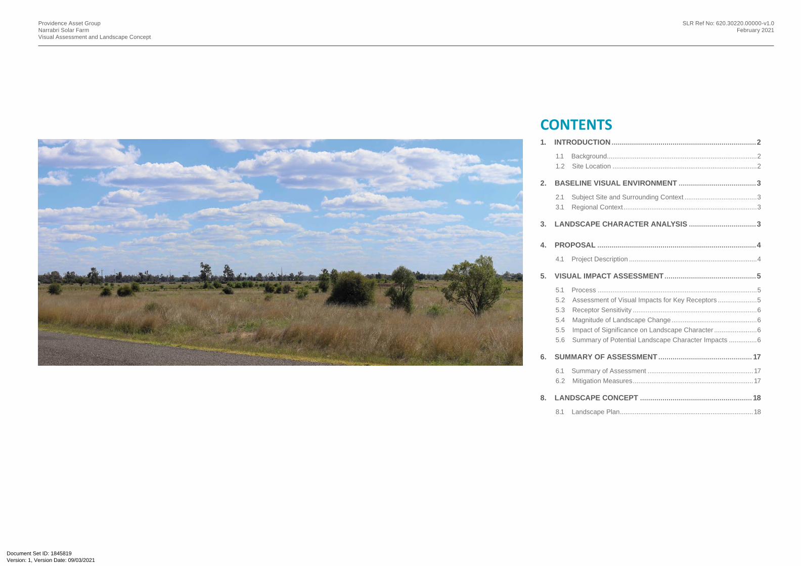
CONTENTS
Providence Asset GroupNarrabri Solar FarmVisual Assessment and Landscape Concept
SLR Ref No: 620.30220.00000-v1.0February 2021
1. INTRODUCTION .......................................................................2
1.1 Background .................................................................................21.2 Site Location ..............................................................................2
2. BASELINE VISUAL ENVIRONMENT ......................................3
2.1 Subject Site and Surrounding Context .......................................33.1 Regional Context ........................................................................3
3. LANDSCAPE CHARACTER ANALYSIS .................................3
4. PROPOSAL ..............................................................................4
4.1 Project Description .....................................................................4
5. VISUAL IMPACT ASSESSMENT .............................................5
5.1 Process ......................................................................................55.2 Assessment of Visual Impacts for Key Receptors .....................55.3 Receptor Sensitivity ...................................................................65.4 Magnitude of Landscape Change ..............................................65.5 Impact of Significance on Landscape Character .......................65.6 Summary of Potential Landscape Character Impacts ...............6
6. SUMMARY OF ASSESSMENT .............................................. 17
6.1 Summary of Assessment ......................................................... 176.2 Mitigation Measures ................................................................. 17
8. LANDSCAPE CONCEPT ....................................................... 18
8.1 Landscape Plan ........................................................................18
Version: 1, Version Date: 09/03/2021Document Set ID: 1845819
Scale (m)0 1000 2000500
Providence Asset GroupNarrabri Solar FarmVisual Assessment and Landscape Concept
SLR Ref No: 620.30220.00000-v1.0February 2021
1. INTRODUCTION
1.1 Background
This Visual Analysis and Landscape Concept has been prepared for the proposed Solar Farm near Narrabri, NSW.
This visual analysis assessment has been prepared to provide an effective and objective assessment of the anticipated high level impacts of the project on the surrounding visual environment.
SLR has worked closely with other members of the project team in determining and rating visual impacts of the proposed solar farm project works on its immediate surrounds as well as suggesting mitigation measures to further reduce any impacts that may occur.
There are 2 parts to this report.
• Visual Analysis, and
• Landscape Concept.
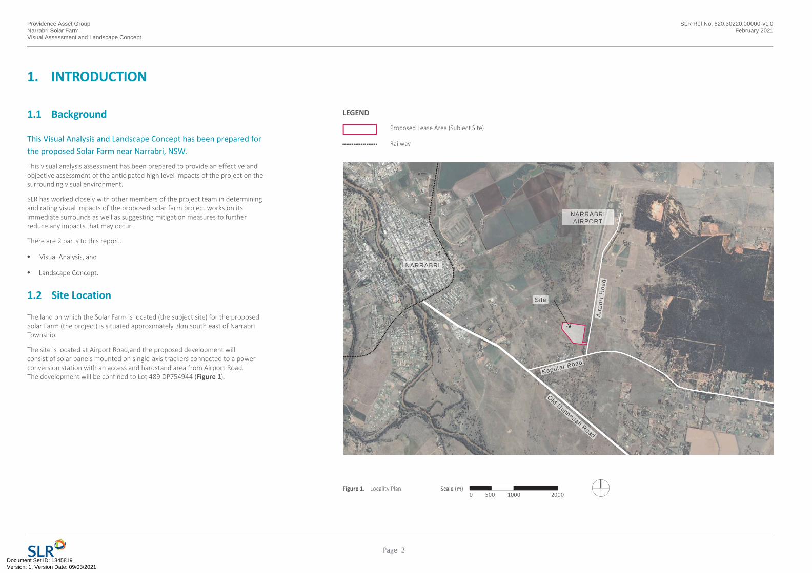
1.2 Site Location
The land on which the Solar Farm is located (the subject site) for the proposed Solar Farm (the project) is situated approximately 3km south east of Narrabri Township.
The site is located at Airport Road,and the proposed development will consist of solar panels mounted on single-axis trackers connected to a power conversion station with an access and hardstand area from Airport Road. The development will be confined to Lot 489 DP754944 (Figure 1).
Figure 1. Locality Plan
NARRABRI
NARRABRIAIRPORT
rpor
t Roa
dA
irpor
t Roa
d
Kaputar RoaKaputar Road
Old Gunnedah Road
Site
Proposed Lease Area (Subject Site)
Railway
LEGEND
2Page
Version: 1, Version Date: 09/03/2021Document Set ID: 1845819
Providence Asset GroupNarrabri Solar FarmVisual Assessment and Landscape Concept
SLR Ref No: 620.30220.00000-v1.0February 2021
2. BASELINE VISUAL ENVIRONMENT
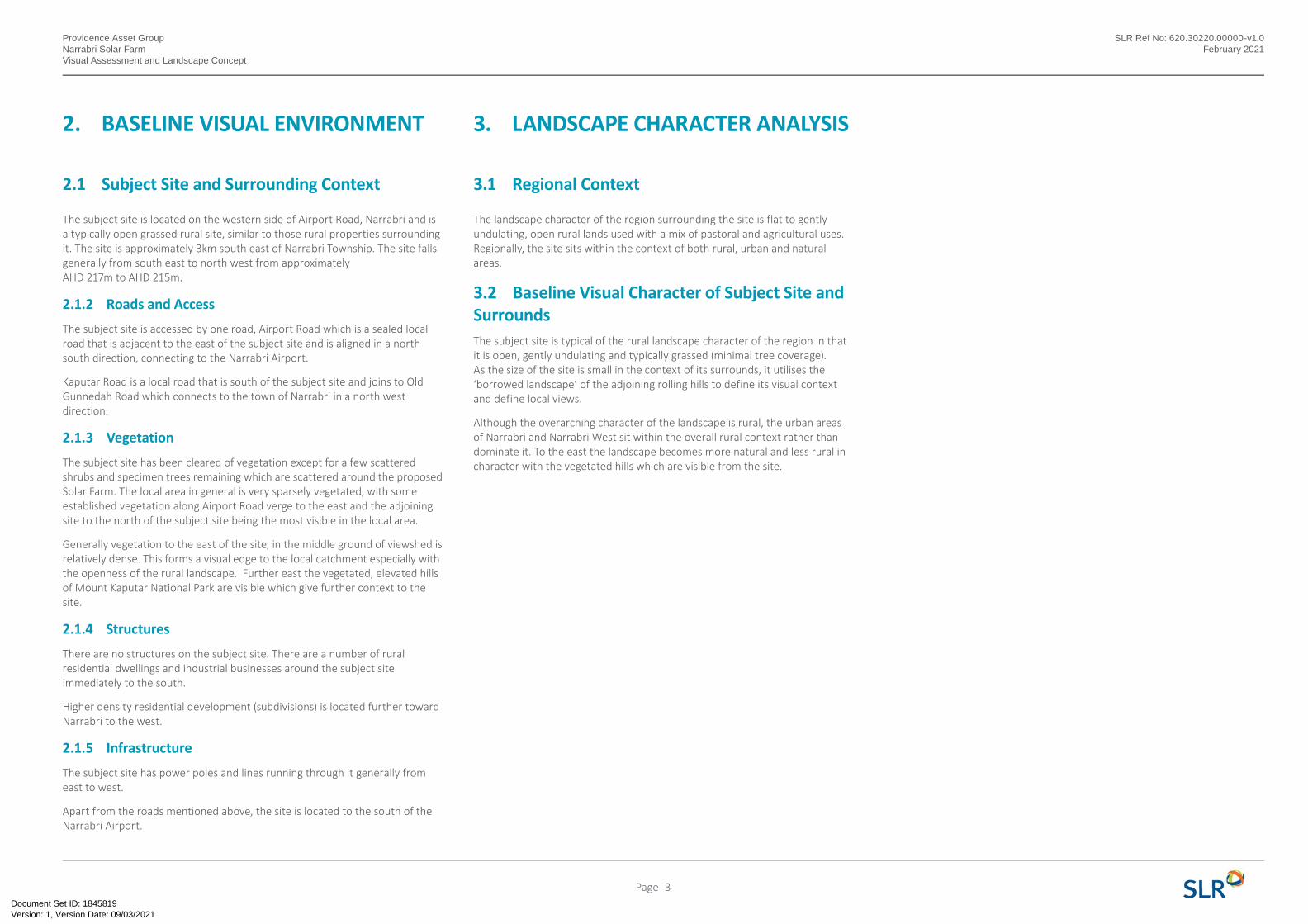
2.1 Subject Site and Surrounding Context
The subject site is located on the western side of Airport Road, Narrabri and is a typically open grassed rural site, similar to those rural properties surrounding it. The site is approximately 3km south east of Narrabri Township. The site falls generally from south east to north west from approximately AHD 217m to AHD 215m.
2.1.2 Roads and Access
The subject site is accessed by one road, Airport Road which is a sealed local road that is adjacent to the east of the subject site and is aligned in a north south direction, connecting to the Narrabri Airport.
Kaputar Road is a local road that is south of the subject site and joins to Old Gunnedah Road which connects to the town of Narrabri in a north west direction.
2.1.3 Vegetation
The subject site has been cleared of vegetation except for a few scattered shrubs and specimen trees remaining which are scattered around the proposed Solar Farm. The local area in general is very sparsely vegetated, with some established vegetation along Airport Road verge to the east and the adjoining site to the north of the subject site being the most visible in the local area.
Generally vegetation to the east of the site, in the middle ground of viewshed is relatively dense. This forms a visual edge to the local catchment especially with the openness of the rural landscape. Further east the vegetated, elevated hills of Mount Kaputar National Park are visible which give further context to the site.
2.1.4 Structures
There are no structures on the subject site. There are a number of rural residential dwellings and industrial businesses around the subject site immediately to the south.
Higher density residential development (subdivisions) is located further toward Narrabri to the west.
2.1.5 Infrastructure
The subject site has power poles and lines running through it generally from east to west.
Apart from the roads mentioned above, the site is located to the south of the Narrabri Airport.
3. LANDSCAPE CHARACTER ANALYSIS
3.1 Regional Context
The landscape character of the region surrounding the site is flat to gently undulating, open rural lands used with a mix of pastoral and agricultural uses. Regionally, the site sits within the context of both rural, urban and natural areas.
3.2 Baseline Visual Character of Subject Site and SurroundsThe subject site is typical of the rural landscape character of the region in that it is open, gently undulating and typically grassed (minimal tree coverage). As the size of the site is small in the context of its surrounds, it utilises the ‘borrowed landscape’ of the adjoining rolling hills to define its visual context and define local views.
Although the overarching character of the landscape is rural, the urban areas of Narrabri and Narrabri West sit within the overall rural context rather than dominate it. To the east the landscape becomes more natural and less rural in character with the vegetated hills which are visible from the site.
3Page
Version: 1, Version Date: 09/03/2021Document Set ID: 1845819
Providence Asset GroupNarrabri Solar FarmVisual Assessment and Landscape Concept
SLR Ref No: 620.30220.00000-v1.0February 2021
4. PROPOSAL
4.1 Project Description
A full description of the proposal is provided within the main Statement of Environmental Effects and site plans, but a brief description is as follows. Section 4.1.1 identifies key elements of the proposal that are of particular relevance to an assessment of impacts on the visual analysis.
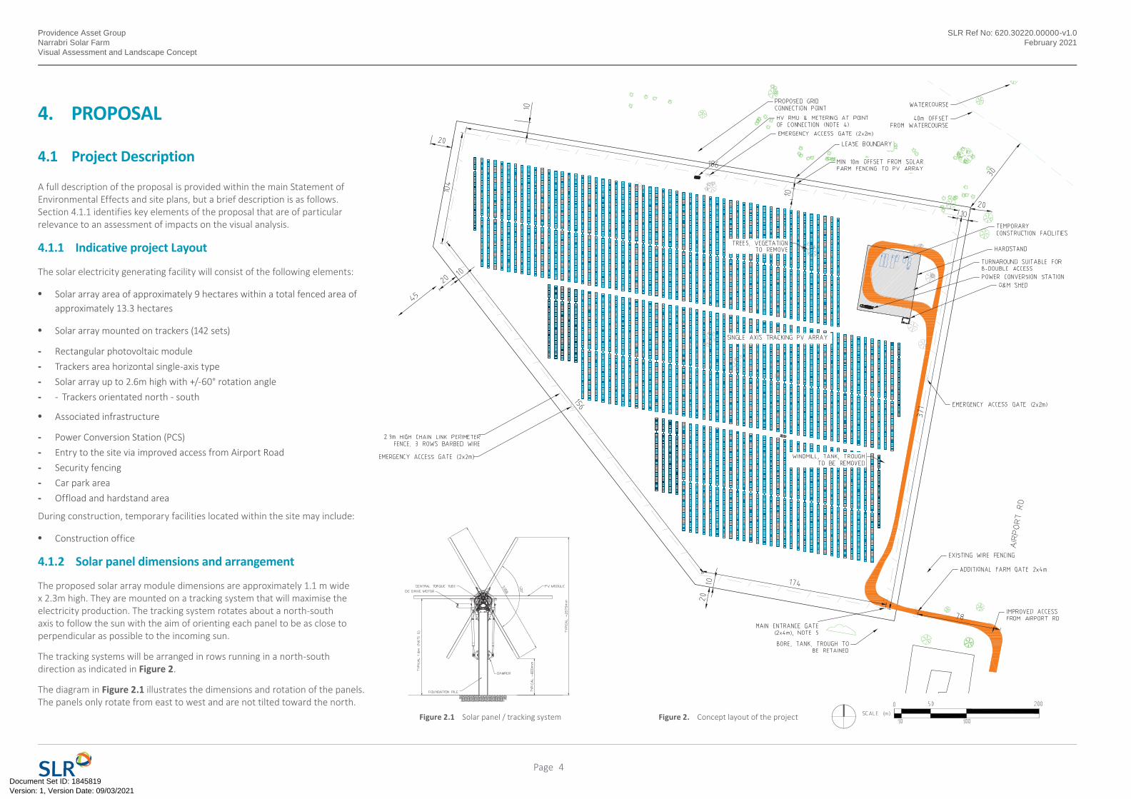
4.1.1 Indicative project Layout
The solar electricity generating facility will consist of the following elements:
• Solar array area of approximately 9 hectares within a total fenced area of approximately 13.3 hectares
• Solar array mounted on trackers (142 sets)
- Rectangular photovoltaic module- Trackers area horizontal single-axis type- Solar array up to 2.6m high with +/-60° rotation angle- - Trackers orientated north - south
• Associated infrastructure
- Power Conversion Station (PCS)- Entry to the site via improved access from Airport Road- Security fencing- Car park area- Offload and hardstand area
During construction, temporary facilities located within the site may include:
• Construction office
4.1.2 Solar panel dimensions and arrangement
The proposed solar array module dimensions are approximately 1.1 m wide x 2.3m high. They are mounted on a tracking system that will maximise the electricity production. The tracking system rotates about a north-south axis to follow the sun with the aim of orienting each panel to be as close to perpendicular as possible to the incoming sun.
The tracking systems will be arranged in rows running in a north-south direction as indicated in Figure 2.
The diagram in Figure 2.1 illustrates the dimensions and rotation of the panels. The panels only rotate from east to west and are not tilted toward the north.
Figure 2. Concept layout of the projectFigure 2.1 Solar panel / tracking system
4Page
Version: 1, Version Date: 09/03/2021Document Set ID: 1845819
Providence Asset GroupNarrabri Solar FarmVisual Assessment and Landscape Concept
SLR Ref No: 620.30220.00000-v1.0February 2021
5. VISUAL IMPACT ASSESSMENT
5.1 Process
The Visual Impact Analysis generally applies the assessment techniques set out in the ‘Guidelines for Landscape and Visual Impact Assessment, Third Edition’ (2013) prepared by The Landscape Institute and the Institute for Environmental Management and Assessment (UK).
The analysis includes the following:
• Review of the proposal (scale, bulk, height, technical specifications and landscape);
• Analysis of the subject site (visual exposure, visual qualities and landscape values);
• Identification of potential impacts on key receptors including the rating of magnitude for each receptor group;
• Rating of impact significance for each receptor group.
• The significance is evaluated as a product of the sensitivity or value of the receptor, and the magnitude of impacts on the receptor;
• Potential mitigation measures to meet the necessary planning requirements and any community expectations;
• The report included a desktop analysis and a visual site investigation in November 2020. The desktop review included the review of aerial photography, site topography and vegetation cover;
Photo-montages were also prepared to inform the analysis.
5.2 Assessment of Visual Impacts for Key Receptors
Photographic imagery was taken of the site to assist in the assessment of visual impacts. Photos were taken with a Canon EOS 6D Mark II digital single-lens reflex (DLSR) camera with a 50 mm lens.
Three photomontage images were prepared to assist in the Visual Analysis process; all from public receptor points.
The five receptors used in the photomontage were selected to investigate a range of visual solutions and illustrating views from areas of perceived sensitivity. During the site investigation, local areas around the site were observed to determine the potential visibility of the proposed Solar Farm.
For the purposes of this Visual Analysis a Photomontage image was produced from each of the three viewpoints chosen. The approximate extent of the proposed Solar Farm has been identified to give a general impression of the location on site and the approximate height.
The Photo montage Images are represented in Section 5.8 and show the following overlays of information.
• Existing visual baseline (existing landform);
• Overlay of the final solar farm proposed development.
5Page
Version: 1, Version Date: 09/03/2021Document Set ID: 1845819
Providence Asset GroupNarrabri Solar FarmVisual Assessment and Landscape Concept
SLR Ref No: 620.30220.00000-v1.0February 2021
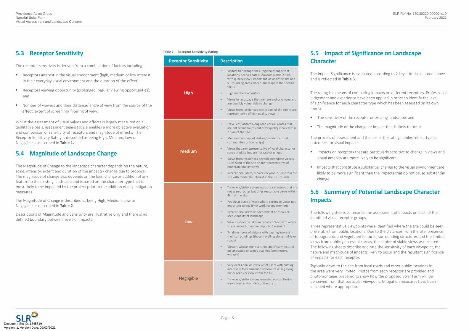
5.3 Receptor Sensitivity
The receptor sensitivity is derived from a combination of factors including:
• Receptors interest in the visual environment (high, medium or low interest in their everyday visual environment and the duration of the effect);
• Receptors viewing opportunity (prolonged, regular viewing opportunities); and
• Number of viewers and their distance/ angle of view from the source of the effect, extent of screening/ filtering of view.
Whilst the assessment of visual values and effects is largely measured on a qualitative basis, assessment against scale enables a more objective evaluation and comparison of sensitivity of receptors and magnitude of effects. The Receptor Sensitivity Rating is described as being High, Medium, Low or Negligible as described in Table 1.
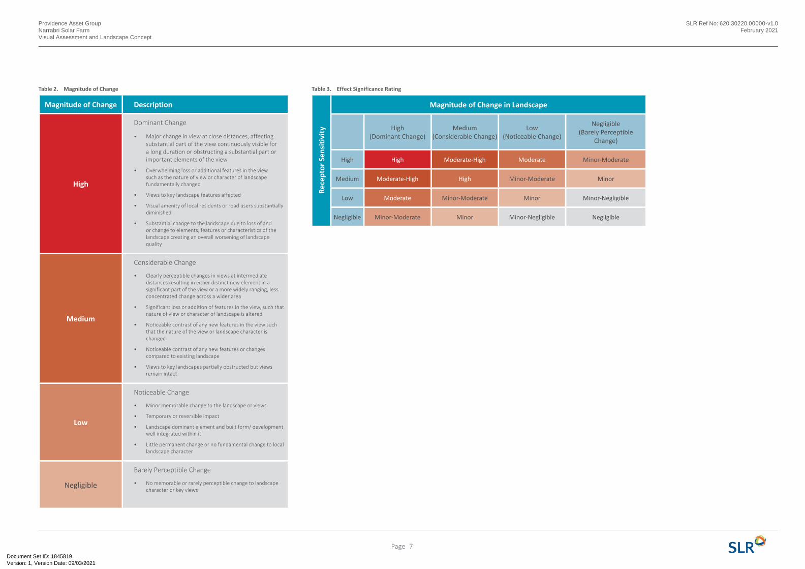
5.4 Magnitude of Landscape Change
The Magnitude of Change to the landscape character depends on the nature, scale, intensity, extent and duration of the impacts/ change due to proposal. The magnitude of change also depends on the loss, change or addition of any feature to the existing landscape and is based on the character type that is most likely to be impacted by the project prior to the addition of any mitigation measures.
The Magnitude of Change is described as being High, Medium, Low or Negligible as described in Table 2.
Descriptions of Magnitude and Sensitivity are illustrative only and there is no defined boundary between levels of impacts.
Receptor Sensitivity Description
High
• Visitors to heritage sites, regionally important locations, scenic routes, lookouts within 2.5km with quality views, important views of the site and surrounding areas where landscape is the specific focus.
• High numbers of visitors
• Views to landscape that are rare and or unique and are possibly vulnerable to change
• Views from residences within 1km of the site or are representative of high quality views
Medium
• Travellers/visitors along roads or rail routes that are not scenic routes but offer quality views within 2.5km of the site
• Medium numbers of visitors/ residents (rural communities or townships)
• Views that are representative of local character or sense of place but are not rare or unique
• Views from residences beyond immediate vicinity (1km-5km) of the site or are representative of moderate quality views
• Recreational users/ viewers beyond 2.5km from the site with moderate interest in their surrounds
Low
• Travellers/visitors along roads or rail routes that are not scenic routes but offer reasonable views within 4km of the site
• People at place of work where setting or views not important to quality of working environment
• Recreational users not dependent on views or scenic quality of landscape
• View experience takes in broad context with which site is visible but not an important element.
• Small numbers of visitors with passing interest in their surroundings (those travelling along mid-level roads)
• Viewers whose interest is not specifically focused on landscape or scenic qualities (commuters, workers)
Negligible
• Very occasional or low level of users with passing interest in their surrounds (those travelling along minor roads or views from the air)
• Travellers/visitors along unsealed roads offering views greater than 4km of the site
Table 1. Receptor Sensitivity Rating 5.5 Impact of Significance on Landscape Character
The Impact Significance is evaluated according to 2 key criteria as noted above and is reflected in Table 3.
The rating is a means of comparing impacts on different receptors. Professional judgement and experience have been applied in order to identify the level of significance for each character type which has been assessed on its own merits.
• The sensitivity of the receptor or existing landscape; and
• The magnitude of the change or impact that is likely to occur.
The process of assessment and the use of the ratings tables reflect typical outcomes for visual impacts.
• Impacts on receptors that are particularly sensitive to change in views and visual amenity are more likely to be significant.
• Impacts that constitute a substantial change to the visual environment are likely to be more significant than the impacts that do not cause substantial change.
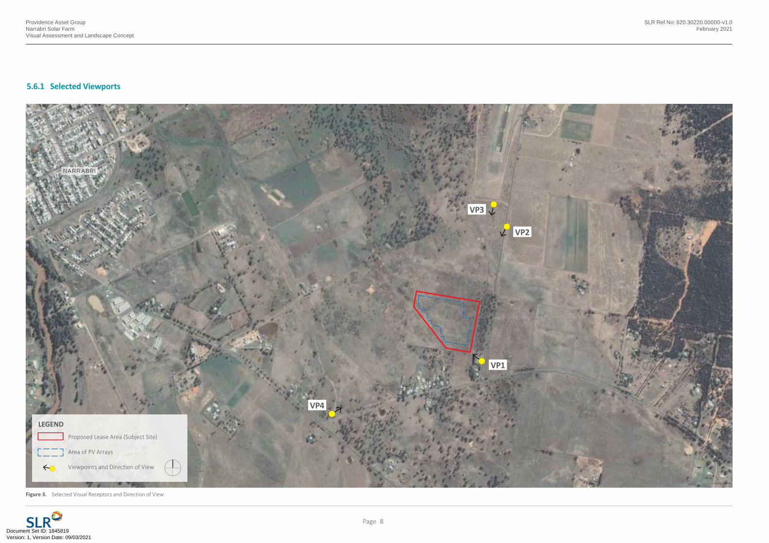
5.6 Summary of Potential Landscape Character Impacts
The following sheets summarise the assessment of impacts on each of the identified visual receptor groups.
Three representative viewpoints were identified where the site could be seen preferably from public locations. Due to the distances from the site, presence of topographic and vegetated features, surrounding structures and the limited views from publicly accessible areas, the choice of viable views was limited. The following sheets describe and rate the sensitivity of each viewpoint, the nature and magnitude of impacts likely to occur and the resultant significance of impacts for each receptor.
Typically views to the site from local roads and other public locations in the area were very limited. Photos from each receptor are provided and photomontages prepared to show how the proposed Solar Farm will be perceived from that particular viewpoint. Mitigation measures have been included where appropriate.
6Page
Version: 1, Version Date: 09/03/2021Document Set ID: 1845819
Providence Asset GroupNarrabri Solar FarmVisual Assessment and Landscape Concept
SLR Ref No: 620.30220.00000-v1.0February 2021
Magnitude of Change Description
High
Dominant Change
• Major change in view at close distances, affecting substantial part of the view continuously visible for a long duration or obstructing a substantial part or important elements of the view
• Overwhelming loss or additional features in the view such as the nature of view or character of landscape fundamentally changed
• Views to key landscape features affected
• Visual amenity of local residents or road users substantially diminished
• Substantial change to the landscape due to loss of and or change to elements, features or characteristics of the landscape creating an overall worsening of landscape quality
Medium
Considerable Change
• Clearly perceptible changes in views at intermediate distances resulting in either distinct new element in a significant part of the view or a more widely ranging, less concentrated change across a wider area
• Significant loss or addition of features in the view, such that nature of view or character of landscape is altered
• Noticeable contrast of any new features in the view such that the nature of the view or landscape character is changed
• Noticeable contrast of any new features or changes compared to existing landscape
• Views to key landscapes partially obstructed but views remain intact
Low
Noticeable Change
• Minor memorable change to the landscape or views
• Temporary or reversible impact
• Landscape dominant element and built form/ development well integrated within it
• Little permanent change or no fundamental change to local landscape character
Negligible
Barely Perceptible Change
• No memorable or rarely perceptible change to landscape character or key views
Table 2. Magnitude of Change Table 3. Effect Significance Rating
Rece
ptor
Sen
sitiv
ity
Magnitude of Change in Landscape
High(Dominant Change)
Medium(Considerable Change)
Low(Noticeable Change)
Negligible(Barely Perceptible
Change)
High High Moderate-High Moderate Minor-Moderate
Medium Moderate-High High Minor-Moderate Minor
Low Moderate Minor-Moderate Minor Minor-Negligible
Negligible Minor-Moderate Minor Minor-Negligible Negligible
7Page
Version: 1, Version Date: 09/03/2021Document Set ID: 1845819
Providence Asset GroupNarrabri Solar FarmVisual Assessment and Landscape Concept
SLR Ref No: 620.30220.00000-v1.0February 2021
5.6.1 Selected Viewports
Figure 3. Selected Visual Receptors and Direction of View
VP1
VP3
VP4
VP2
Proposed Lease Area (Subject Site)
Area of PV Arrays
Viewpoints and Direction of View
LEGEND
NARRABRI
8Page
Version: 1, Version Date: 09/03/2021Document Set ID: 1845819
Providence Asset GroupNarrabri Solar FarmVisual Assessment and Landscape Concept
SLR Ref No: 620.30220.00000-v1.0February 2021
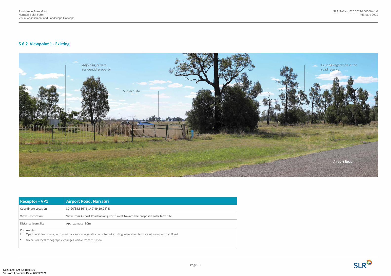
5.6.2 Viewpoint 1 - Existing
Receptor - VP1 Airport Road, Narrabri
Coordinate Location 30°20’35.586” S 149°49’20.94” E
View Description View from Airport Road looking north west toward the proposed solar farm site.
Distance from Site Approximate 80m
Comments• Open rural landscape, with minimal canopy vegetation on site but existing vegetation to the east along Airport Road
• No hills or local topographic changes visible from this view
Subject Site
Subject Site
Adjoining private residential property
Existing vegetation in the road reserve
Airport Road
9Page
Version: 1, Version Date: 09/03/2021Document Set ID: 1845819
Providence Asset GroupNarrabri Solar FarmVisual Assessment and Landscape Concept
SLR Ref No: 620.30220.00000-v1.0February 2021
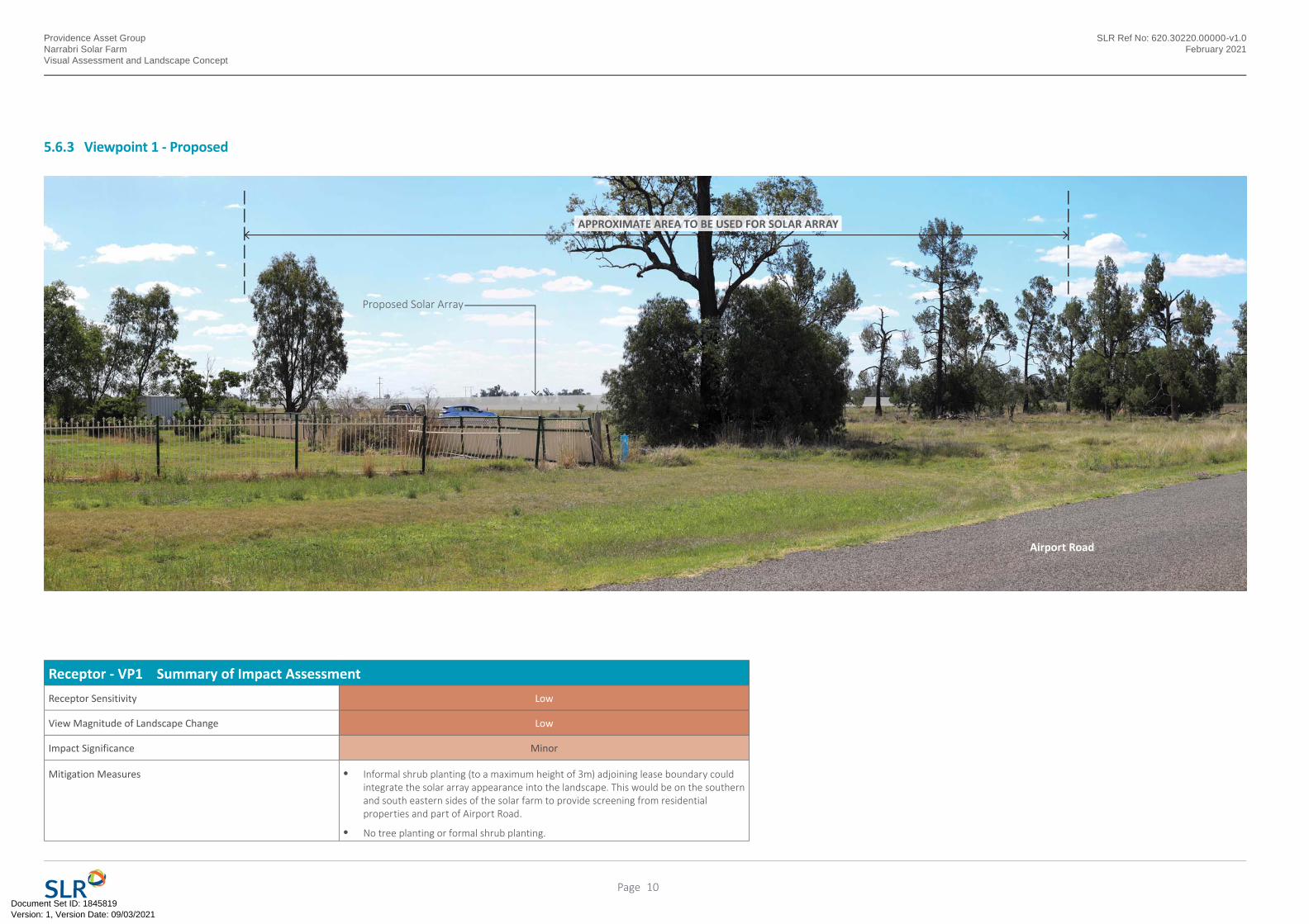
5.6.3 Viewpoint 1 - Proposed
Receptor - VP1 Summary of Impact Assessment
Receptor Sensitivity Low
View Magnitude of Landscape Change Low
Impact Significance Minor
Mitigation Measures • Informal shrub planting (to a maximum height of 3m) adjoining lease boundary could integrate the solar array appearance into the landscape. This would be on the southern and south eastern sides of the solar farm to provide screening from residential properties and part of Airport Road.
• No tree planting or formal shrub planting.
APPROXIMATE AREA TO BE USED FOR SOLAR ARRAY
Proposed Solar Array
Airport Road
10Page
Version: 1, Version Date: 09/03/2021Document Set ID: 1845819
Providence Asset GroupNarrabri Solar FarmVisual Assessment and Landscape Concept
SLR Ref No: 620.30220.00000-v1.0February 2021
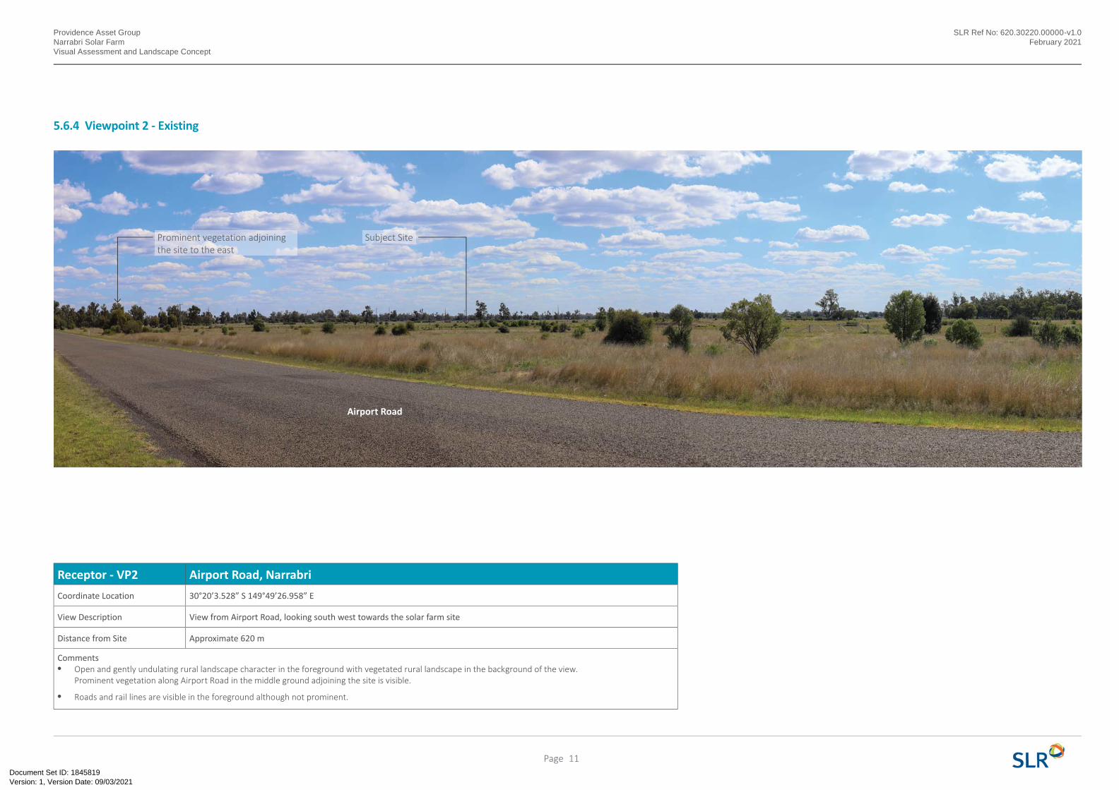
5.6.4 Viewpoint 2 - Existing
Receptor - VP2 Airport Road, Narrabri
Coordinate Location 30°20’3.528” S 149°49’26.958” E
View Description View from Airport Road, looking south west towards the solar farm site
Distance from Site Approximate 620 m
Comments• Open and gently undulating rural landscape character in the foreground with vegetated rural landscape in the background of the view.
Prominent vegetation along Airport Road in the middle ground adjoining the site is visible.
• Roads and rail lines are visible in the foreground although not prominent.
Subject SiteProminent vegetation adjoining the site to the east
Airport Road
11Page
Version: 1, Version Date: 09/03/2021Document Set ID: 1845819
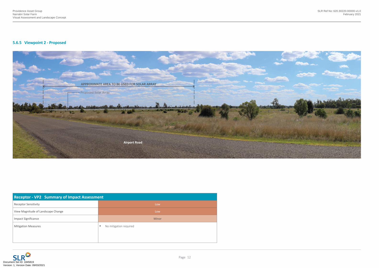
APPROXIMATE AREA TO BE USED FOR SOLAR ARRAY
Proposed Solar Array
Receptor - VP2 Summary of Impact Assessment
Receptor Sensitivity Low
View Magnitude of Landscape Change Low
Impact Significance Minor
Mitigation Measures • No mitigation required
Providence Asset GroupNarrabri Solar FarmVisual Assessment and Landscape Concept
SLR Ref No: 620.30220.00000-v1.0February 2021
5.6.5 Viewpoint 2 - Proposed
Airport Road
12Page
Version: 1, Version Date: 09/03/2021Document Set ID: 1845819
Providence Asset GroupNarrabri Solar FarmVisual Assessment and Landscape Concept
SLR Ref No: 620.30220.00000-v1.0February 2021
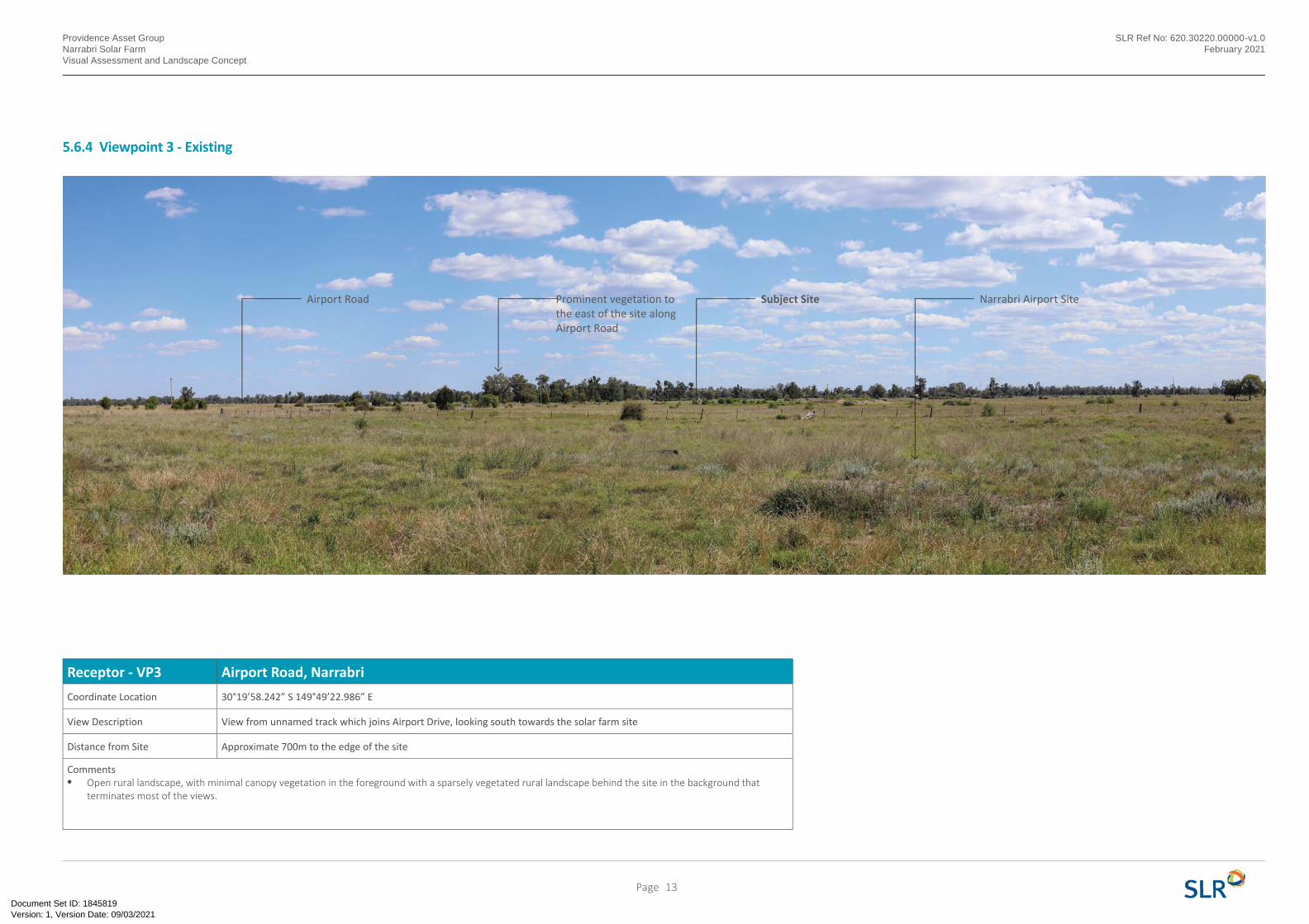
Receptor - VP3 Airport Road, Narrabri
Coordinate Location 30°19’58.242” S 149°49’22.986” E
View Description View from unnamed track which joins Airport Drive, looking south towards the solar farm site
Distance from Site Approximate 700m to the edge of the site
Comments• Open rural landscape, with minimal canopy vegetation in the foreground with a sparsely vegetated rural landscape behind the site in the background that
terminates most of the views.
Subject Site Narrabri Airport SiteProminent vegetation to the east of the site along Airport Road
Airport Road
5.6.4 Viewpoint 3 - Existing
13Page
Version: 1, Version Date: 09/03/2021Document Set ID: 1845819
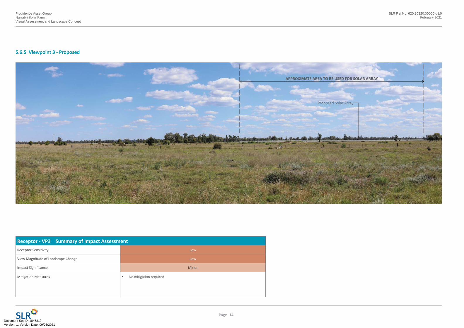
APPROXIMATE AREA TO BE USED FOR SOLAR ARRAY
Proposed Solar Array
Providence Asset GroupNarrabri Solar FarmVisual Assessment and Landscape Concept
SLR Ref No: 620.30220.00000-v1.0February 2021
5.6.5 Viewpoint 3 - Proposed
Receptor - VP3 Summary of Impact Assessment
Receptor Sensitivity Low
View Magnitude of Landscape Change Low
Impact Significance Minor
Mitigation Measures • No mitigation required
14Page
Version: 1, Version Date: 09/03/2021Document Set ID: 1845819
Providence Asset GroupNarrabri Solar FarmVisual Assessment and Landscape Concept
SLR Ref No: 620.30220.00000-v1.0February 2021
5.6.6 Viewpoint 4 - Existing
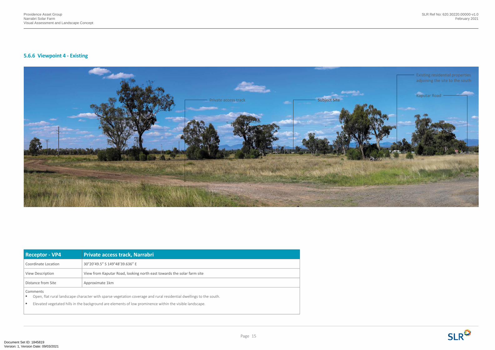
Receptor - VP4 Private access track, Narrabri
Coordinate Location 30°20’49.5” S 149°48’39.636” E
View Description View from Kaputar Road, looking north east towards the solar farm site
Distance from Site Approximate 1km
Comments• Open, flat rural landscape character with sparse vegetation coverage and rural residential dwellings to the south.
• Elevated vegetated hills in the background are elements of low prominence within the visible landscape.
Subject SitePrivate access track
Existing residential properties adjoining the site to the south
Kaputar Road
15Page
Version: 1, Version Date: 09/03/2021Document Set ID: 1845819
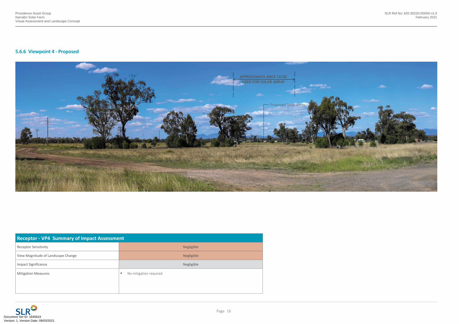
APPROXIMATE AREA TO BE USED FOR SOLAR ARRAY
Proposed Solar Array
Providence Asset GroupNarrabri Solar FarmVisual Assessment and Landscape Concept
SLR Ref No: 620.30220.00000-v1.0February 2021
Receptor - VP4 Summary of Impact Assessment
Receptor Sensitivity Negligible
View Magnitude of Landscape Change Negligible
Impact Significance Negligible
Mitigation Measures • No mitigation required
5.6.6 Viewpoint 4 - Proposed
16Page
Version: 1, Version Date: 09/03/2021Document Set ID: 1845819
Providence Asset GroupNarrabri Solar FarmVisual Assessment and Landscape Concept
SLR Ref No: 620.30220.00000-v1.0February 2021
6.2 Mitigation Measures
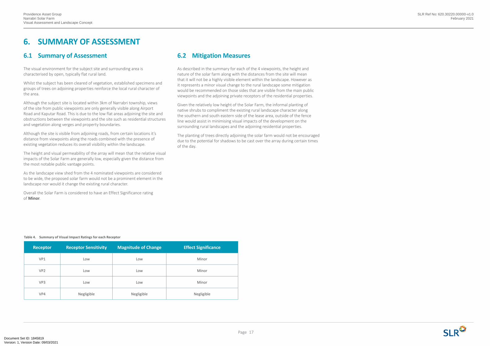
As described in the summary for each of the 4 viewpoints, the height and nature of the solar farm along with the distances from the site will mean that it will not be a highly visible element within the landscape. However as it represents a minor visual change to the rural landscape some mitigation would be recommended on those sides that are visible from the main public viewpoints and the adjoining private receptors of the residential properties.
Given the relatively low height of the Solar Farm, the informal planting of native shrubs to compliment the existing rural landscape character along the southern and south eastern side of the lease area, outside of the fence line would assist in minimising visual impacts of the development on the surrounding rural landscapes and the adjoining residential properties.
The planting of trees directly adjoining the solar farm would not be encouraged due to the potential for shadows to be cast over the array during certain times of the day.
6. SUMMARY OF ASSESSMENT
Table 4. Summary of Visual Impact Ratings for each Receptor
6.1 Summary of Assessment
The visual environment for the subject site and surrounding area is characterised by open, typically flat rural land.
Whilst the subject has been cleared of vegetation, established specimens and groups of trees on adjoining properties reinforce the local rural character of the area.
Although the subject site is located within 3km of Narrabri township, views of the site from public viewpoints are only generally visible along Airport Road and Kaputar Road. This is due to the low flat areas adjoining the site and obstructions between the viewpoints and the site such as residential structures and vegetation along verges and property boundaries.
Although the site is visible from adjoining roads, from certain locations it’s distance from viewpoints along the roads combined with the presence of existing vegetation reduces its overall visibility within the landscape.
The height and visual permeability of the array will mean that the relative visual impacts of the Solar Farm are generally low, especially given the distance from the most notable public vantage points.
As the landscape view shed from the 4 nominated viewpoints are considered to be wide, the proposed solar farm would not be a prominent element in the landscape nor would it change the existing rural character.
Overall the Solar Farm is considered to have an Effect Significance rating of Minor.
Receptor Receptor Sensitivity Magnitude of Change Effect Significance
VP1 Low Low Minor
VP2 Low Low Minor
VP3 Low Low Minor
VP4 Negligible Negligible Negligible
17Page
Version: 1, Version Date: 09/03/2021Document Set ID: 1845819
Hardstand
Providence Asset GroupNarrabri Solar FarmVisual Assessment and Landscape Concept
SLR Ref No: 620.30220.00000-v1.0February 2021
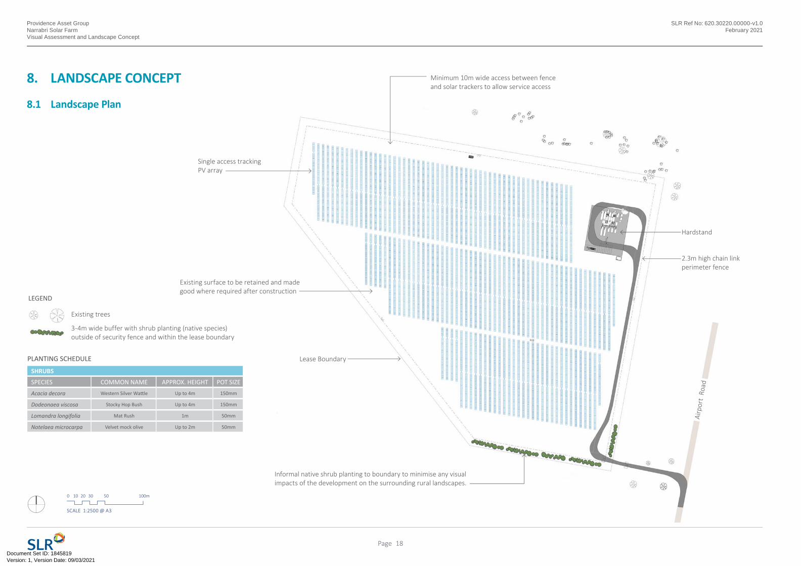
8. LANDSCAPE CONCEPT
8.1 Landscape Plan
0 10 20 30 50 100m
SCALE 1:2500 @ A3
LEGEND
Existing trees
PLANTING SCHEDULE
SHRUBS
SPECIES COMMON NAME APPROX. HEIGHT POT SIZE
Acacia decora Western Silver Wa le Up to 4m 150mm
Dodeonaea viscosa Stocky Hop Bush Up to 4m 150mm
Lomandra longifolia Mat Rush 1m 50mm
Notelaea microcarpa Velvet mock olive Up to 2m 50mm
3-4m wide buffer with shrub planting (native species) outside of security fence and within the lease boundary
2.3m high chain link perimeter fence
Single access tracking PV array
Lease Boundary
Airp
ort
Road
Minimum 10m wide access between fence and solar trackers to allow service access
Existing surface to be retained and made good where required after construction
Informal native shrub planting to boundary to minimise any visual impacts of the development on the surrounding rural landscapes.
18Page
Version: 1, Version Date: 09/03/2021Document Set ID: 1845819

Providence Asset GroupNarrabri Solar FarmVisual Assessment and Landscape Concept
SLR Ref No: 620.30220.00000-v1.0February 2021
Version: 1, Version Date: 09/03/2021Document Set ID: 1845819
ASIA PACIFIC OFFICES
BRISBANE
Level 2, 15 Astor Terrace
Spring Hill QLD 4000
Australia
T: +61 7 3858 4800
F: +61 7 3858 4801
CANBERRA
GPO 410
Canberra ACT 2600
Australia
T: +61 2 6287 0800
F: +61 2 9427 8200
DARWIN
Unit 5, 21 Parap Road
Parap NT 0820
Australia
T: +61 8 8998 0100
F: +61 8 9370 0101
GOLD COAST
Level 2, 194 Varsity Parade
Varsity Lakes QLD 4227
Australia
M: +61 438 763 516
MACKAY
21 River Street
Mackay QLD 4740
Australia
T: +61 7 3181 3300
MELBOURNE
Level 11, 176 Wellington Parade
East Melbourne VIC 3002
Australia
T: +61 3 9249 9400
F: +61 3 9249 9499
NEWCASTLE
10 Kings Road
New Lambton NSW 2305
Australia
T: +61 2 4037 3200
F: +61 2 4037 3201
PERTH
Ground Floor, 503 Murray Street
Perth WA 6000
Australia
T: +61 8 9422 5900
F: +61 8 9422 5901
TOWNSVILLE SOUTH
12 Cannan Street
South Townsville QLD 4810
Australia
T: +61 7 4722 8000
F: +61 7 4722 8001
WOLLONGONG
Level 1, The Central Building
UoW Innova on Campus
North Wollongong NSW 2500
Australia
T: +61 2 4249 1000
AUCKLAND
Level 4, 12 O’Connell Street
Auckland 1010
New Zealand
T: 0800 757 695
NELSON
6/A Cambridge Street
Richmond, Nelson 7020
New Zealand
T: +64 274 898 628
www.slrconsulting.com
Version: 1, Version Date: 09/03/2021Document Set ID: 1845819