Embed Size (px)
Citation preview

NASA's Earth Observing Data and Information System (EOSDIS)
Kevin MurphyEOSDIS System ArchitectNASA Goddard Space Flight Center
Copernicus Big Data Workshop13 March 2014
Brussels, Belgium

0 pt1 pt
MISSION OPERATIONS
SCIENCE OPERATIONS
EARTH SCIENCE DATA OPERATIONS
DATA ACQUISITION
FLIGHT OPERATIONS,
DATA CAPTURE,INITIAL
PROCESSING, BACKUP
ARCHIVE
DATA TRANSPORT TO
DATA CENTERS/SIPSsSCIENCE DATA PROCESSING,
DATA MANAGEMENT,INTEROPERABLE DATA,ARCHIVE, AND DISTRIBUTION
DISTRIBUTION ANDDATA ACCESS
Research
Education
Value-AddedProviders
EarthSystem Models
InternationalPartners
Decision SupportSystems
Infrastructure
(Search, Order,
Distribution)
Tracking and Data
Relay Satellite (TDRS)
Instrument Teams and Science Investigator-ledProcessing Systems (SIPSs)
White SandsComplex (WSC)
EOS PolarGround Stations
Direct Broadcast (DB)
Direct Broadcast/Direct Readout
Stations
EOSDISData Centers
EOS Data OperationsSystem (EDOS)Data Processing
EOS OperationsCenter (EOC)
Mission Control
EOS Spacecraft Interagency
Data Centers
National Aeronautics and Space Administration
NASA INTEGRATED
SERVICES NETWORK
(NISN) MISSION SERVICES

EOSDIS as a Seamless, Efficient User Driven System
Present NASA’s EOSDIS as an interoperable system of systems where users can select, view, interact and download the data they need transparently from all subsystems in support of interdisciplinary Earth Science research.
Supplement current data system capabilities with new interoperable technologies to create a foundation for future evolution.
• Support technology infusion of tools developed by internal programs and by industry
EOSDIS capabilities and feature development is prioritized through DAAC User Working Groups (science experts) and input from community data system programs
Data Metadata as a Service
Imagery as a Service
Data as a Service
Partnerships commercial
clouds
Today Tomorrow Working Towards

Central Reusable Capabilities
Earthdata: the EOSDIS website (http://earthdata.nasa.gov)
Metadata Services
• ECHO: Searchable catalog of granule metadata for NASA datasets (OpenSearch, CSW, OGC interfaces)
• Global Change Master Directory (GCMD): Searchable catalog of over 26,000 NASA and International dataset collections
User Tools (e.g.)
• Reverb – search and order tool
• Global Imagery Browse Services (GIBS) – full resolution imagery derived from NASA products in a standardized manner to any web-connected client (Open Sourced)
• Worldview - highly responsive interface to explore GIBS imagery and download the underlying data
• Giovanni – Quick-Start Exploratory Data Analysis
Metrics System (EMS): collects and reports on data ingest, production, archive, and distribution across all EOSDIS data centers
User Registration System: provides a centralized and mechanism for user registration and account management for all EOSDIS system.

Examples of Relevant DAAC Capabilities
Sentinel 1 (ASF DAAC)
• ASF DAAC offers a variety of SAR-derived higher level products via easy-to-use Web interfaces
• MapReady Toolkit
Sentinel 2 (LPDAAC)
• (?)
Sentinel 3 (ODPS, LAADS, LPDAAC, …)
• SeaDAS - science processing from Level-1B through Level-3 with a host of NASA standard and alternative ocean product algorithms (including source code). Also data product analysis and visualization based on ESA's BEAM tool.
• Match-up to field data - Level-1/Level-2 browser will identify all data granules for which coincident field data exists in the NASA SeaBASS in situ bio-optical archive, and provide the data as a unified order.
• In situ SeaBASS archive for product validation and the NOMAD database for bio-optical algorithm development
Sentinel 5p
• Giovanni
• Subsetting and reformatting
5

NASA Sentinel GatewayLeveraging Existing EOSDIS Capabilities
For Sentinel 1, 2(?), 3, 5P, NASA will leverage proven gateway and redistribution capabilities, currently used for S-NPP• Single network interface relieves
bandwidth load on European networks and
• Long term archival and end user distribution by DAACs (e.g. Sentinal-1 by ASF DAAC).
• Provides metric reports back to the EC/ESA on product distribution and usage
• Leverages entire suite of NASA’s EOSDIS capabilities including capturing and reporting metrics on distribution and usage of Sentinel products by U.S. scientists

Copernicus Support Levels
Two support levels for mirroring Sentinel (A and B series) data have been investigated based on guidance.
• Level 1 Support: Develop gateway and improve networks to support the transfer, ingest, archival and distribution• L? products for Sentinel 1• L1 products for Sentinel 2, 3 and S5P
• Level 2+ Support: NASA processing centers (e.g. SIPS) create higher level products that are ingested, archived and distributed from designated DAACs.• Costs presented are in addition to Level 1 Support.• Assumption: Science Team involvement and funding to develop
higher level products would be required, but are not included in MMOPS overguide submission

Level 1 Support
URSEMS GIBS CMR
ASF – S1
OBPG – S3
LAADS – S3
US Gov. - NOAA - NRL - Other
L0 and L1Gateway for S1, S2, S3, S5P @
GSFC
Metric Reports
LPDAAC – S2
CDDIS – S3
EOSDIS Systems
Dat
a M
irror
@ D
AA
Cs
Terms:S1,2,3,5P - Sentinel 1, 2, 3, 5PASF – Alaska Satellite FacilityOBPG – Ocean Biological Processing GroupLAADS – Level 1 and Atmosphere Archive and Distribution SystemLPDAAC – Land Processes DAACCDDIS – Crustal Dynamics Data and Information SystemURS – EOSDIS User Registration SystemGIBS – Global Imagery Browse ServicesEMS – EOSDIS Metrics SystemCMR – Common Metadata SystemDHuS – Copernicus Data Hub System
L0 and L1
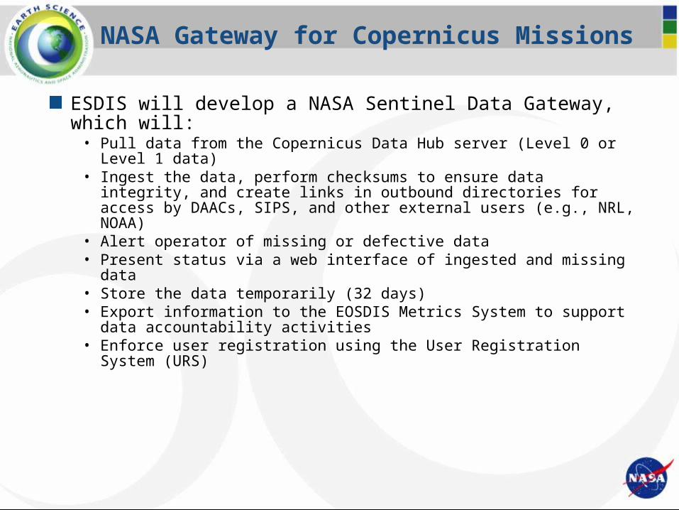
NASA Gateway for Copernicus Missions
ESDIS will develop a NASA Sentinel Data Gateway, which will:• Pull data from the Copernicus Data Hub server (Level 0 or Level 1 data)• Ingest the data, perform checksums to ensure data integrity, and create links in
outbound directories for access by DAACs, SIPS, and other external users (e.g., NRL, NOAA)
• Alert operator of missing or defective data• Present status via a web interface of ingested and missing data• Store the data temporarily (32 days)• Export information to the EOSDIS Metrics System to support data accountability
activities• Enforce user registration using the User Registration System (URS)

Sentinel 1 A/B
Instrument: C-band SAR (5.405 GHz)• Level-0 products are available to data users in Stripmap (SM),
Interferometric Wide swath (IW) and Extra Wide swath (EW)• Wave (WV) product only available as L2 product (not included)
Applications: Monitoring sea ice, oil spills, marine winds & waves, land-use change, land deformation among others, and to respond to emergencies such as floods and earthquakes
DAAC: Alaska Satellite Facility
NASA Internal Use Only 10
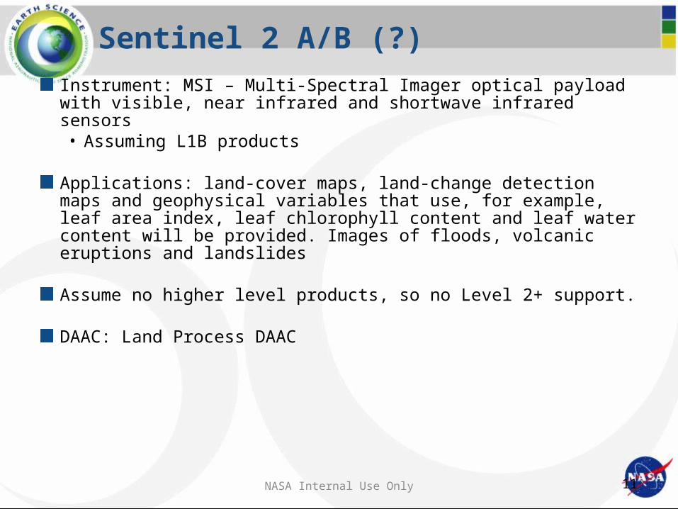
Sentinel 2 A/B (?)
Instrument: MSI – Multi-Spectral Imager optical payload with visible, near infrared and shortwave infrared sensors• Assuming L1B products
Applications: land-cover maps, land-change detection maps and geophysical variables that use, for example, leaf area index, leaf chlorophyll content and leaf water content will be provided. Images of floods, volcanic eruptions and landslides
Assume no higher level products, so no Level 2+ support.
DAAC: Land Process DAAC
NASA Internal Use Only 11
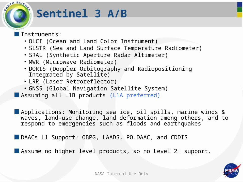
Sentinel 3 A/B
Instruments: • OLCI (Ocean and Land Color Instrument)• SLSTR (Sea and Land Surface Temperature Radiometer)• SRAL (Synthetic Aperture Radar Altimeter)• MWR (Microwave Radiometer)• DORIS (Doppler Orbitography and Radiopositioning Integrated
by Satellite)• LRR (Laser Retroreflector)• GNSS (Global Navigation Satellite System)
Assuming all L1B products (L1A preferred)
Applications: Monitoring sea ice, oil spills, marine winds & waves, land-use change, land deformation among others, and to respond to emergencies such as floods and earthquakes
DAACs L1 Support: OBPG, LAADS, PO.DAAC, and CDDIS
Assume no higher level products, so no Level 2+ support.
NASA Internal Use Only 12

Sentinel 5P
Instruments: TROPOMI (Tropospheric Ozone Monitoring Instrument) and UVNS (Ultraviolet Visible Near-infrared Shortwave)
Applications: Atmospheric composition studies, tropospheric monitoring and air quality, ozone monitoring and climate monitoring, through the study of atmospheric chemicals
DAAC Level 1 Support: GES DISCAssume no higher level products, so no Level 2+ support.
NASA Internal Use Only 13