Embed Size (px)
Citation preview
Nashville Civic Design Center
Nashville and Its Region:Making ConnectionsChristine Kreyling
GETTING AROUND"Our national flower is the con-crete cloverleaf." Lewis Mumford, Quote (October 8, 1961)
Transportation infrastructure is a means to an end, not an end in itself. The purpose of the infrastructure is to enable people and goods to move from place to place as efficiently and eco-nomically as possible.
For much of Nashville’s history, the framework of movement was diversified because it served different vehicles and was relatively task specific. The long distance avenues were first the river for boats, then rails for trains, then runways for airplanes. Streets were for local traffic--biped and quadruped, then trol-leys and cars, and later buses. Sidewalks distinguished paths for human foot traffic. The turnpikes, or farm-to-market roads, bridged the gap between short and long distance travel.
After World War II, however, Nashville--like much of the nation--declined from a multimodal transportation system into a transportation monoculture. City planners designed an infra-structure dedicated overwhelmingly to a single mode--the in-ternal combustion engine--to serve patterns of newly segre-gated land uses.
The traditional pikes by which farmers had delivered their products to city markets became major arterials, increasingly shared by long distance travelers and commuters dwelling in new subdivisions adjacent to these roads. Zoning rules en-couraged commerce to migrate out of neighborhood centers to the arterials. Suburban villas were replaced by motel courts and gas stations and strips of shops, farms by shopping malls. These developments served as a magnet for more traffic. The traffic lights and curb cuts required for all this retail slowed traffic. The arterial, serving long distance and local needs, served neither very well.
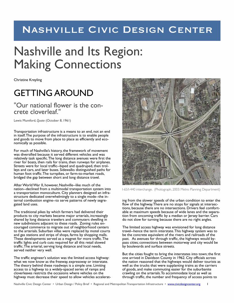
The traffic engineer’s solution was the limited access highway: what we now know as the freeway, expressway or interstate. The theory behind these roadways is a simple one. Limiting access to a highway to a widely-spaced series of ramps and cloverleaves restricts the occasions where vehicles on the highway must decrease their speed to allow vehicles accelerat-
ing from the slower speeds of the urban condition to enter the flow of the highway. There are no stops for signals at intersec-tions, because there are no intersections. Drivers feel comfort-able at maximum speeds because of wide lanes and the separa-tion from oncoming traffic by a median or Jersey barrier. Cars do not slow for turning because there are no right angles.
The limited access highway was envisioned for long distance travel--hence the term interstate. This highway system was to be the concrete equivalent of the rivers and railroads of the past. As avenues for through traffic, the highways would by-pass cities; connections between motorway and city would be by boulevards and surface streets.
But the cities fought to bring the interstates into town; the first one arrived in Davidson County in 1962. City officials across the nation reasoned that the highways would deliver tourists as well as the trucks that were supplanting trains as the carriers of goods, and make commuting easier for the suburbanite crawling on the arterials. To accommodate local as well as through traffic, the number and frequency of access points to
Nashville Civic Design Center • Urban Design / Policy Brief • Regional and Metropolitan Transportation Infrastructure • www.civicdesigncenter.org 1
I-65/I-440 interchange. (Photograph, 2003: Metro Planning Department)
the highway had to be increased. The limited access highway was asked to serve contradictory needs--just like the arterials--and its design purpose was compromised.
“After all, what is a pedestrian? He is a man who has two cars--one being driven by his wife, the other by one of his children.” Robert Bradbury, New York Times (September 5, 1962)
Despite much recent demonization, the interstate is not inher-ently evil. And no one wants to go back to the days of driving all the way from Nashville to Florida on a two-lane state high-way. But as a design for long distance travel adapted to provide local circulation, the limited access highway does not perform well. Neither does the arterial lined with strip malls, curb cuts and cul-de-sacs.
Both road patterns concentrate rather than disperse traffic. Cul-de-sac subdivisions feeding arterials offer no alternative routes. And once you’re on the interstate, you pretty much have to stay on it until you reach your destination. Concentra-tion is the bane of the automotive age, as is apparent in the congestion and growing length of Nashville’s rush hours. And the congestion--and air pollution--will get even worse. The Federal Highway Administration predicts a doubling of freight truck through traffic on the interstates in the next 15 to 20 years.
The relentless fixation of transportation planning on a single mode--the automobile--and the demands on the highway infra-structure to serve local and through traffic has, at the begin-ning of the 21st century, produced a system that, as a means of traveling within or into cities, is no longer economical nor effi-cient.
Nashville needs a variety of transportation modes for local circulation: mass transit, bicycles and the good old-fashioned human foot, as well as cars. And the most economical and effi-cient infrastructure for a multimodal system serving local transportation needs is the traditional urban street system.
An interlocked network--usually a grid of blocks--supplies ve-hicles and pedestrians with access points to a particular thor-oughfare at each intersection. The driver thus has multiple op-tions for getting from place to place. If an accident clogs traffic on one road, for example, a driver can turn right or left and use an alternative route. The speed of such a system is limited by stop signs and signals, by trolleys or buses pausing to take on or discharge passengers, by cars slowing to turn at corners and drivers looking for an on-street parking space. The limits to speed make for pedestrian-friendliness.
But Nashville’s urban street system has been fractured by lim-ited access highways. These highways, in addition to their inabil-ity to meet the current variety of transportation needs, are also hostile to the form that a city must take to be successful.
The Model Transportation System
For a city to succeed as the downtown of the region, transpor-tation infrastructure must provide a dignified and appropriate sequence of arrival, diverse and accessible links to the region, and access to attractions with regional appeal, such as sports venues and cultural centers.
For Nashville to enhance its identity as a city of neighbor-hoods, transportation infrastructure must define several ele-ments including neighborhood form; i.e., clear and distinct edges and centers, and links among the neighborhoods, and between each neighborhood and downtown. A network of streets, as well as bicycle and pedestrian paths, organized into a clear hierarchy: boulevards/avenues, collector streets, local streets and sidewalks. A block structure strongly related to the street network and sized at pedestrian scale. In addition, the
Nashville Civic Design Center • Urban Design / Policy Brief • Regional and Metropolitan Transportation Infrastructure • www.civicdesigncenter.org 2
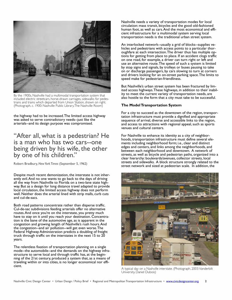
By the 1900s, Nashville had a multimodal transportation system that included electric streetcars, horse-drawn carriages, sidewalks for pedes-trians and trains which departed from Union Station, shown on right. (Photograph, c. 1900: Nashville Public Library, The Nashville Room)
A typical day on a Nashville interstate. (Photograph, 2003: Vanderbilt University, Daniel Dubois)
placement of buildings on the blocks that define street walls must be of human scale.
The fundamental obstacle to Nashville as the downtown of the region and the city of neighborhoods is the arterial and high-way infrastructure.
Weaning Ourselves from the Highway: The Four-Step Program
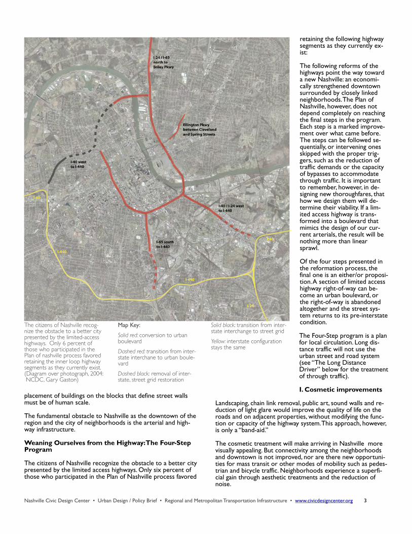
The citizens of Nashville recognize the obstacle to a better city presented by the limited access highways. Only six percent of those who participated in the Plan of Nashville process favored
retaining the following highway segments as they currently ex-ist:
The following reforms of the highways point the way toward a new Nashville: an economi-cally strengthened downtown surrounded by closely linked neighborhoods. The Plan of Nashville, however, does not depend completely on reaching the final steps in the program. Each step is a marked improve-ment over what came before. The steps can be followed se-quentially, or intervening ones skipped with the proper trig-gers, such as the reduction of traffic demands or the capacity of bypasses to accommodate through traffic. It is important to remember, however, in de-signing new thoroughfares, that how we design them will de-termine their viability. If a lim-ited access highway is trans-formed into a boulevard that mimics the design of our cur-rent arterials, the result will be nothing more than linear sprawl.
Of the four steps presented in the reformation process, the final one is an either/or proposi-tion. A section of limited access highway right-of-way can be-come an urban boulevard, or the right-of-way is abandoned altogether and the street sys-tem returns to its pre-interstate condition.
The Four-Step program is a plan for local circulation. Long dis-tance traffic will not use the urban street and road system (see “The Long Distance Driver” below for the treatment of through traffic).
I. Cosmetic improvements
Landscaping, chain link removal, public art, sound walls and re-duction of light glare would improve the quality of life on the roads and on adjacent properties, without modifying the func-tion or capacity of the highway system. This approach, however, is only a “band-aid.”
The cosmetic treatment will make arriving in Nashville more visually appealing. But connectivity among the neighborhoods and downtown is not improved, nor are there new opportuni-ties for mass transit or other modes of mobility such as pedes-trian and bicycle traffic. Neighborhoods experience a superfi-cial gain through aesthetic treatments and the reduction of noise.
Nashville Civic Design Center • Urban Design / Policy Brief • Regional and Metropolitan Transportation Infrastructure • www.civicdesigncenter.org 3
The citizens of Nashville recog-nize the obstacle to a better city presented by the limited-access highways. Only 6 percent of those who participated in the Plan of nashville process favored retaining the inner loop highway segments as they currently exist. (Diagram over photograph, 2004: NCDC, Gary Gaston)
Map Key:
Solid red: conversion to urban boulevard
Dashed red: transition from inter-state interchane to urban boule-vard
Dashed black: removal of inter-state, street grid restoration
Solid black: transition from inter-state interchange to street grid
Yellow: interstate configuration stays the same
“The automobile has not merely taken over the street, it has dis-solved the living tissue of the city. Its appetite for space is absolutely insatiable; moving and parked it devours urban land, leaving the buildings as mere islands of habit-able space in a sea of dangerous and ugly traffic.”James Marston Fitch, New York Times (May 1, 1960)
II. More Links
The main benefit to more links is the increased connectivity between neighborhoods and to the downtown, as well as new route possibilities for public transit, pedestrians, and bicyclists. Additional land for redevelopment also becomes available at the intersections of the links.
Seattle’s Freeway Park, a wide greenspace near the city’s con-vention center that crosses a highway to connect downtown with neighborhoods, is one example of such a linkage. Another is a plan by the city of Minneapolis for a two-block-wide “bridge” across a highway that will contain primarily residential development.
III. Rationalized Interchanges
A right-angle interface between the highways and the public streets is pedestrian and bicycle friendly--because right angles slow traffic down--and provides opportunities for bus stops, dedicated transit lanes and multimodal transportation hubs. Reclaimed land--hundreds of acres--is returned to the down-town and neighborhood fabric, and to Metro tax rolls.
IV. Option 1. Highway to Boulevard.
The segment of interstate on the East Bank of the Cumberland River has the following characteristics that make it a good can-didate for highway-to-boulevard conversion. The highway con-forms to the geometry of the street system around it. The land on either side of the highway could be easily organized into neighborhoods that would use the boulevard as a "high street." The type of medium-scale development and land uses associ-ated with an urban boulevard would be in keeping with the density desirable for this area.
If the highway is converted to a boulevard lined with trees and mid-rise buildings, the aesthetics of arrival into the city is greatly enhanced. Because the boulevard is--unlike the interstate--integrated into the existing street system, what had been a barrier between East Nashville and the East Bank and downtown now becomes an avenue and a destination pulling the sections of the city together. A right-of-way that served only motor vehicles now also provides for mass transit, non-motorized vehicles and pedestrians, possibly with dedicated lanes for transit and bikes. Significant housing and retail can be programmed into the old interstate right-of-way which is now freed for redevelopment, thus enhancing the adjacent neigh-borhoods.
Nashville Civic Design Center • Urban Design / Policy Brief • Regional and Metropolitan Transportation Infrastructure • www.civicdesigncenter.org 4
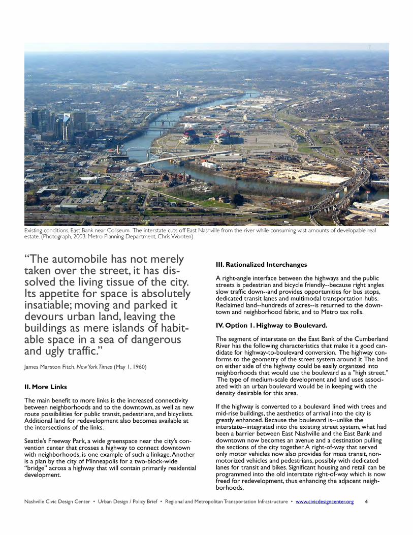
Existing conditions, East Bank near Coliseum. The interstate cuts off East Nashville from the river while consuming vast amounts of developable real estate. (Photograph, 2003: Metro Planning Department, Chris Wooten)
Nashville Civic Design Center • Urban Design / Policy Brief • Regional and Metropolitan Transportation Infrastructure • www.civicdesigncenter.org 5
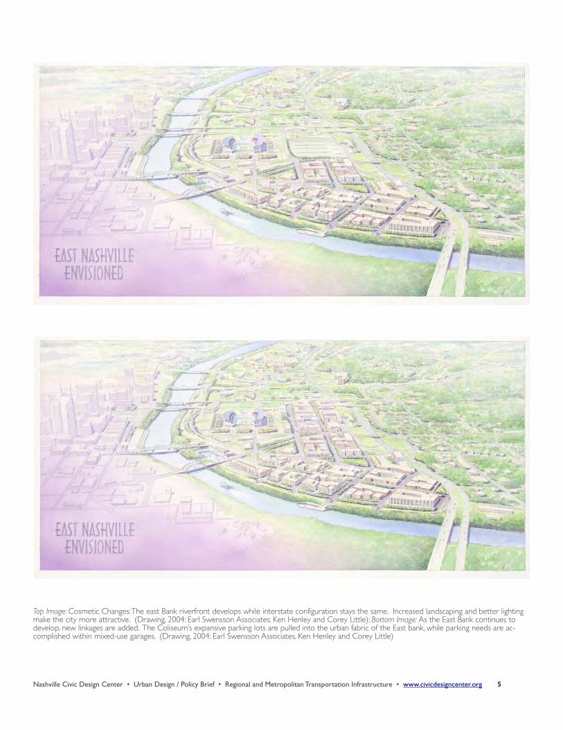
Top Image: Cosmetic Changes: The east Bank riverfront develops while interstate configuration stays the same. Increased landscaping and better lighting make the city more attractive. (Drawing, 2004: Earl Swensson Associates, Ken Henley and Corey Little); Bottom Image: As the East Bank continues to develop, new linkages are added. The Coliseum’s expansive parking lots are pulled into the urban fabric of the East bank, while parking needs are ac-complished within mixed-use garages. (Drawing, 2004: Earl Swensson Associates, Ken Henley and Corey Little)
Nashville Civic Design Center • Urban Design / Policy Brief • Regional and Metropolitan Transportation Infrastructure • www.civicdesigncenter.org 6
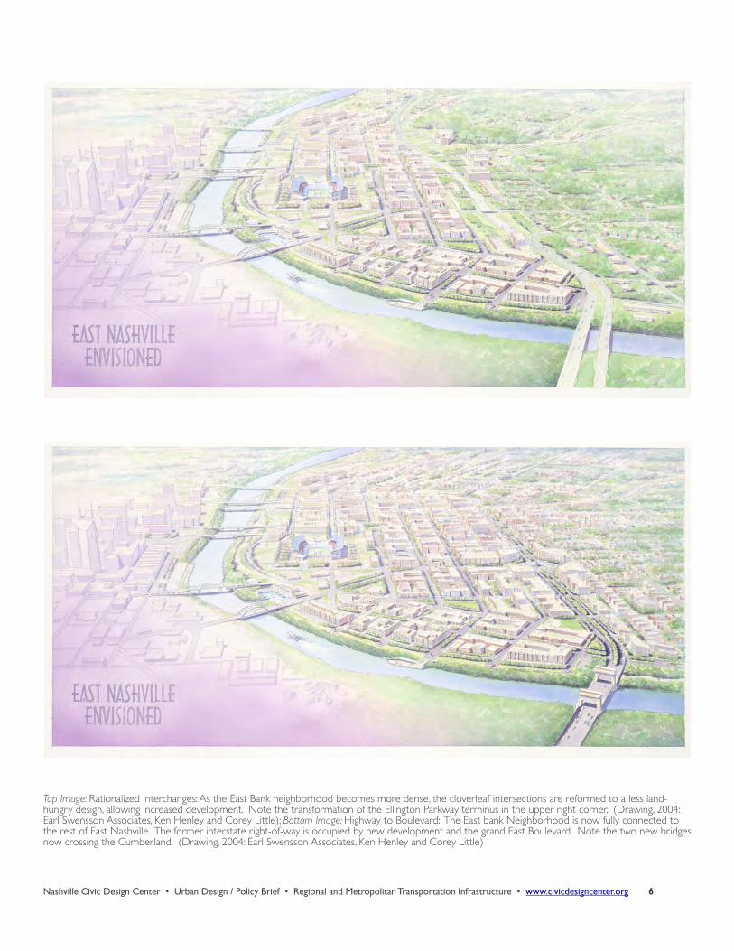
Top Image: Rationalized Interchanges: As the East Bank neighborhood becomes more dense, the cloverleaf intersections are reformed to a less land-hungry design, allowing increased development. Note the transformation of the Ellington Parkway terminus in the upper right corner. (Drawing, 2004: Earl Swensson Associates, Ken Henley and Corey Little); Bottom Image: Highway to Boulevard: The East bank Neighborhood is now fully connected to the rest of East Nashville. The former interstate right-of-way is occupied by new development and the grand East Boulevard. Note the two new bridges now crossing the Cumberland. (Drawing, 2004: Earl Swensson Associates, Ken Henley and Corey Little)
Nashville Civic Design Center • Urban Design / Policy Brief • Regional and Metropolitan Transportation Infrastructure • www.civicdesigncenter.org 7
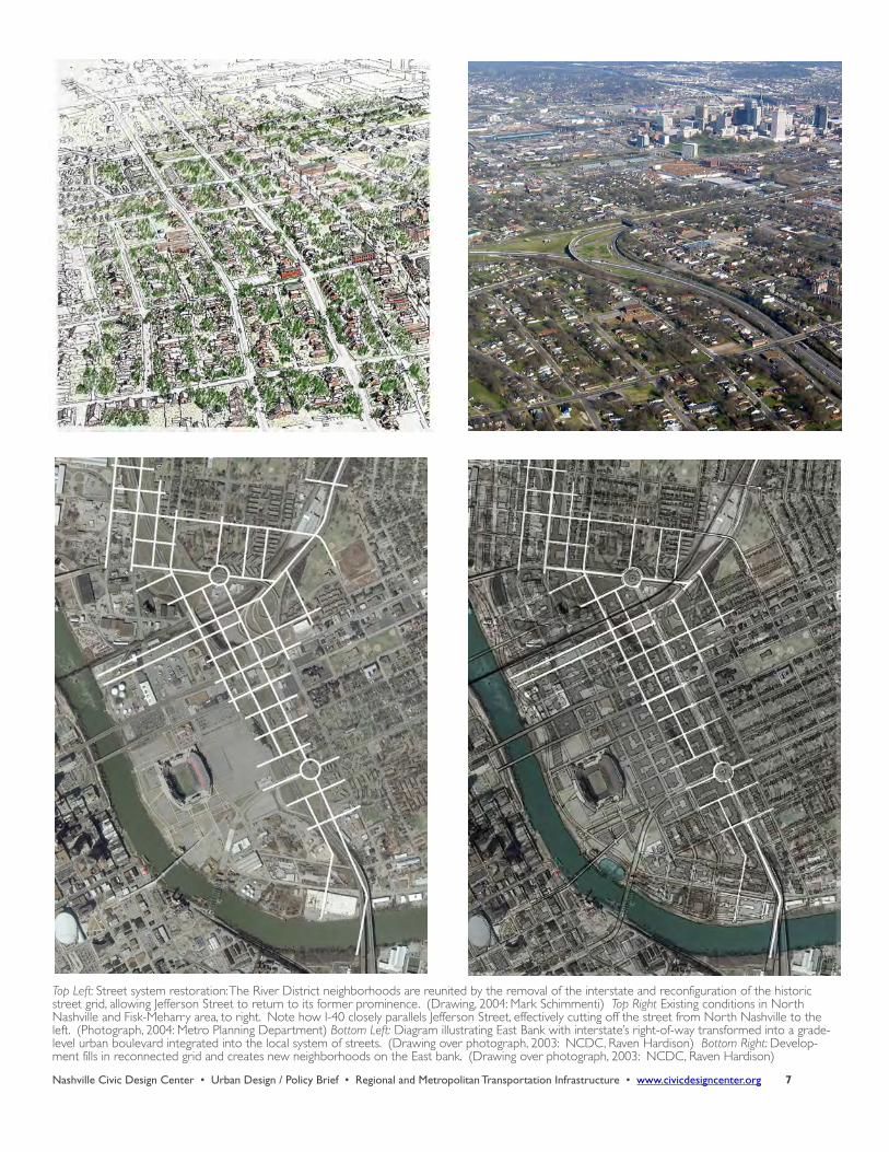
Top Left: Street system restoration: The River District neighborhoods are reunited by the removal of the interstate and reconfiguration of the historic street grid, allowing Jefferson Street to return to its former prominence. (Drawing, 2004: Mark Schimmenti) Top Right Existing conditions in North Nashville and Fisk-Meharry area, to right. Note how I-40 closely parallels Jefferson Street, effectively cutting off the street from North Nashville to the left. (Photograph, 2004: Metro Planning Department) Bottom Left: Diagram illustrating East Bank with interstate’s right-of-way transformed into a grade-level urban boulevard integrated into the local system of streets. (Drawing over photograph, 2003: NCDC, Raven Hardison) Bottom Right: Develop-ment fills in reconnected grid and creates new neighborhoods on the East bank. (Drawing over photograph, 2003: NCDC, Raven Hardison)
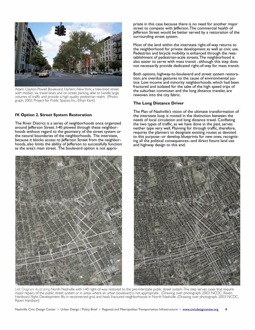
IV. Option 2. Street System Restoration
The River District is a series of neighborhoods once organized around Jefferson Street. I-40 plowed through these neighbor-hoods without regard to the geometry of the street system or the natural boundaries of the neighborhoods. The interstate, because it blocks access to Jefferson Street from the neighbor-hoods, also limits the ability of Jefferson to successfully function as the area’s main street. The boulevard option is not appro-
priate in this case because there is no need for another major street to compete with Jefferson. The commercial health of Jefferson Street would be better served by a restoration of the surrounding street system.
Most of the land within the interstate right-of-way returns to the neighborhood for private development as well as civic use. Pedestrian and bicycle mobility is enhanced through the rees-tablishment of pedestrian-scale streets. The neighborhood is also easier to serve with mass transit , although this step does not necessarily provide dedicated right-of-way for mass transit.
Both options, highway-to-boulevard and street system restora-tion, are overdue gestures to the cause of environmental jus-tice. Low income and minority neighborhoods, which had been fractured and isolated for the sake of the high speed trips of the suburban commuter and the long distance traveler, are rewoven into the city fabric.
The Long Distance Driver
The Plan of Nashville’s vision of the ultimate transformation of the interstate loop is rooted in the distinction between the needs of local circulation and long distance travel. Conflating the two types of traffic, as we have done in the past, serves neither type very well. Planning for through traffic, therefore, requires the planners to designate existing routes as devoted to this purpose--or develop blueprints for new ones, recogniz-ing all the political consequences--and direct future land use and highway design to this end.
Nashville Civic Design Center • Urban Design / Policy Brief • Regional and Metropolitan Transportation Infrastructure • www.civicdesigncenter.org 8
Adam Clayton Powell Boulevard, Harlem, New York; a tree-lined street with median, six travel lanes and on-street parking, able to handle large volumes of traffic and provide a high quality pedestrian realm. (Photo-graph, 2002: Project for Public Spaces, Inc., Ethan Kent)
Left: Diagram illustrating North Nashville with I-40 right-of-way restored to the pre-interstate public street system. This step serves cases that require major repairs of the public street system or in areas where an urban boulevard is not appropriate. (Drawing over photograph, 2003: NCDC, Raven Hardison); Right: Development fills in reconnected grid, and heals fractured neighborhoods in North Nashville. (Drawing over photograph, 2003: NCDC, Raven Hardison)
“Bypasses are devices that allow some people to dash from point A to point B very fast while other people dash from point B to point A very fast.”Douglas Adams, The Hitchhiker’s Guide to the Galaxy (1979)
According to the Nashville Area Metropolitan Planning Organi-zation (MPO) and the Tennessee Department of Transportation (TDOT), only approximately 35 percent of the traffic on the interstate inner loop is long-distance through traffic. When the inner-loop is transformed into boulevards or returned to the traditional street system, as the Plan presents, these streets will not be designed for high speed vehicles passing through town.
The Plan anticipates that long distance drivers will reroute themselves to the high speed bypasses: Briley Parkway and I-440. For this assumption to succeed, long range planners must determine that the future of these highways is primarily to serve high speed through traffic, and then develop strategies to manage the traffic count or number of vehicles, and the mobil-ity of these roads, to enable this traffic to efficiently bypass the city.
The Traffic Count
LOCAL USAGE
The citizens who participated in the Plan of Nashville process look forward to a time when there is a drastic reduction in local usage of the limited-access high-ways. This reduction depends on changes in how we plan and build our city. Planning and development must en-able the greater use of public transpor-tation for mobility and access across the city, as well as the use of bicycle and pedestrian modes for trips of shorter distance, to achieve fewer car trips per household.
When the arterials are reformed and the inner-loop is transformed, the result-ing network of streets and boulevards should absorb the local traffic--including trips by mass transit and bicycle--that represents 65 percent of today's inter-state usage. More of the remaining limited-access highway's capacity is thus available for through traffic.
LONG DISTANCE
Interstate trucking represents up to 30 percent of Nashville’s through traffic, according to TDOT data. Travelers in cars make up the rest. Economic forces and the availability of alternate forms of travel and freight movement will deter-mine the through traffic counts of the future.
TDOT has plans for passenger rail linking the major cities of Tennessee. But preliminary estimates indicate that train speeds will not reach that posted for vehicles on the interstates. TDOT needs a more ambitious plan for passenger rail, with speeds at least comparable to that of cars and trucks--and the state must have the political will to fund it--if we are to pull drivers off the interstates and on to the trains.
Investment at the state and federal level in the rail freight infra-structure would increase the speed and capacity of the rails. Such investment could mitigate the projected doubling of freight truck traffic on the interstates in the next 15 to 20 years.
BYPASS CAPACITY
The feasibility of the interstate transformation depends on the ability of Briley Parkway and I-440 to handle the diverted through traffic. This capability in turn depends on a collective agreement among planners that a primary purpose of these highways is to provide high speed routes to bypass the city. Some gains in mobility may be realized by the reconfiguration of intersections and limiting local access. The Plan strongly rec-ommends that there be no increase in the actual size of the rights-of-way. American transportation history has already demonstrated that adding new capacity to roadways just in-duces more traffic to use them.
Nashville Civic Design Center • Urban Design / Policy Brief • Regional and Metropolitan Transportation Infrastructure • www.civicdesigncenter.org 9
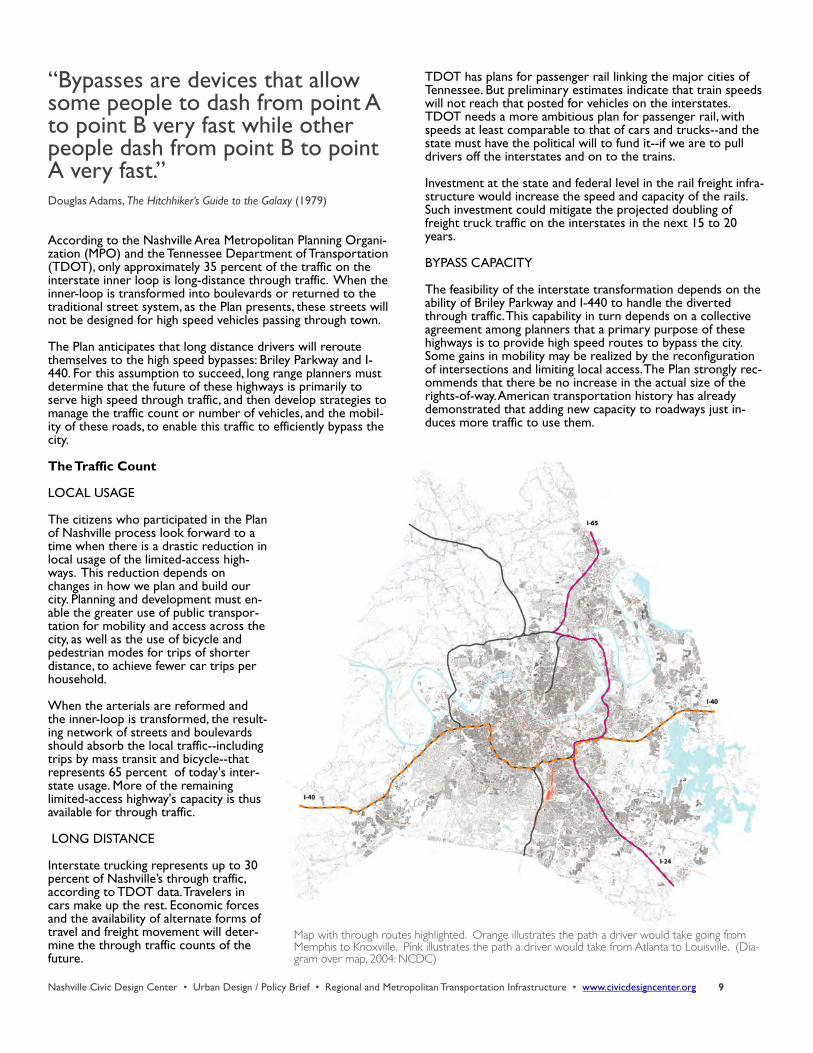
Map with through routes highlighted. Orange illustrates the path a driver would take going from Memphis to Knoxville. Pink illustrates the path a driver would take from Atlanta to Louisville. (Dia-gram over map, 2004: NCDC)
The changes the Plan of Nashville presents for the arterials and interstates cannot occur in isolation. The timing of the changes is dependent upon many factors that will require close coordi-nation between land use and transportation planning.
The relocation of freight hubs out of the urban areas would remove the need for highways designed to accommodate semis. Increases in density, particularly for residential popula-tion in the study area of the Plan, could subtract cars from the interstates and add them to the urban streets or mass transit systems. An increase of 25,000 people who both live and work in downtown, for example, would remove a comparable num-ber of single-occupancy-vehicles (SOV) from the highways dur-ing rush hour. The changes are also contingent on a shift in our transportation investment from adding road capacity to in-creasing mass transit opportunities. More residential develop-ment within quick walking distance of the arterials and collec-tor streets would enable mass transit to function more eco-nomically and efficiently.
Ultimately, getting the interstates out of urban Nashville is a long term vision that will require many large and small steps--all coordinated and moving in the same direction. By making that vision a goal on our civic horizon, and then evaluating cur-rent and future land use and transportation plans in terms of their respective abilities to reach that goal, we can make a sys-tem that works equally well for long distance and local traffic.
Mass Transit for Local Circulation
It doesn’t take a rocket scientist to figure out that, in the com-petition to move more people using fewer vehicles and less road capacity, mass transit has it over the automobile every time. Yet the Plan of Nashville citizen survey of April 2003 found that 88 percent of the approximately 500 who partici-pated had never used Nashville’s public transportation system. Seven percent responded that they used transit one to three times per month, three percent utilized the system one to three times per week, and only two percent took the bus every day. Why are the figures so dismal?
For starters, the service the Metro Transit Authority (MTA) offers is not particularly frequent. Service is also organized in a radial route plan, which works for commuting to and from downtown. But riders seeking other points on the map--East Nashvillians going to the Vanderbilt medical complex or South Nashvillians to Green Hills, for example--must go through downtown and engage in time-consuming transfers. Inconven-ient service is not a good strategy for getting people out of their cars and on to mass transit.
The system is also underfunded at all government levels: fed-eral, state and local. Higher appropriations would enable MTA to offer more frequent service as well as direct service to more dispersed origins and destinations.
Nashville Civic Design Center • Urban Design / Policy Brief • Regional and Metropolitan Transportation Infrastructure • www.civicdesigncenter.org 10
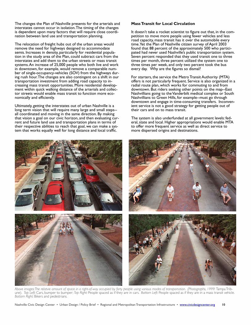
Above images: The relatvie amount of space in a right-of-way occupied by forty people using various modes of transportation. (Photographs, 1999: Tampa Trib-une). Top Left: Cars, bumper to bumper; Top Right: People spaced as if they are in cars. Bottom Left: People spaced as if they are in a mass transit vehicle. Bottom Right: Bikers and pedestrians.
Due to this underfunding, Nashville buses are not cheap to ride. The cost per trip is $1.45, which is the highest fare among Tennessee’s larger cities. An unlimited weekly pass is $14.70, an unlimited monthly pass $48.00, not big discounts if you use the bus to commute to work five days a week--and for little else.
If you are one of the approximately 15,000 state office workers in downtown, for example, and are provided with free parking, there is little economic incentive for you to take the bus.
The ultimate villain in Nashville’s underutilization of mass tran-sit, however, is the city’s sprawling, low-density development patterns. According to USA Today’s 2001 sprawl index, Nashville is America’s most sprawling city. Most routes lack the ridership pool to make them economically viable. Providing all of Metro--including subdivisions on one-acre lots--with comparable levels of service would pretty much guarantee that the level of serv-ice would be mediocre.
Because Nashville sprawls, Nashvillians also drive--a lot. The most recent statistics from the Federal Highway Administration state that the average daily vehicle miles traveled per capita within the Nashville metropolitan region is 34.3 miles. Not coincidentally, Nashville also owns the dubious honor of having received in 2003 an F from the American Lung Association for its air quality. Tennesseans have long claimed to have the best roads in the country. Those roads have taken us to some of the worst air pollution and suburban sprawl.Getting people out of their cars and on to mass transit could help to mitigate Nashville’s deteriorating air quality, as well as ease the congestion on our roadways. To make transit work better for more people, however, we must have more people in greater densities living and working near transit routes--which will require drastic changes in the way we use land for development--and we must provide them with faster, cheaper and more convenient service. Some cities, Charlotte, Denver, Pittsburgh, and Atlanta, have begun to expand their transit options beyond the conventional bus which competes with cars for road space. Bus-Rapid-Transit (BRT) and/or light rail, commuter rail, HOV lanes and dedicated bus lanes, are just a few of the new methods that are being used to alter the reliance upon the automobile.
Nashville Civic Design Center • Urban Design / Policy Brief • Regional and Metropolitan Transportation Infrastructure • www.civicdesigncenter.org 11
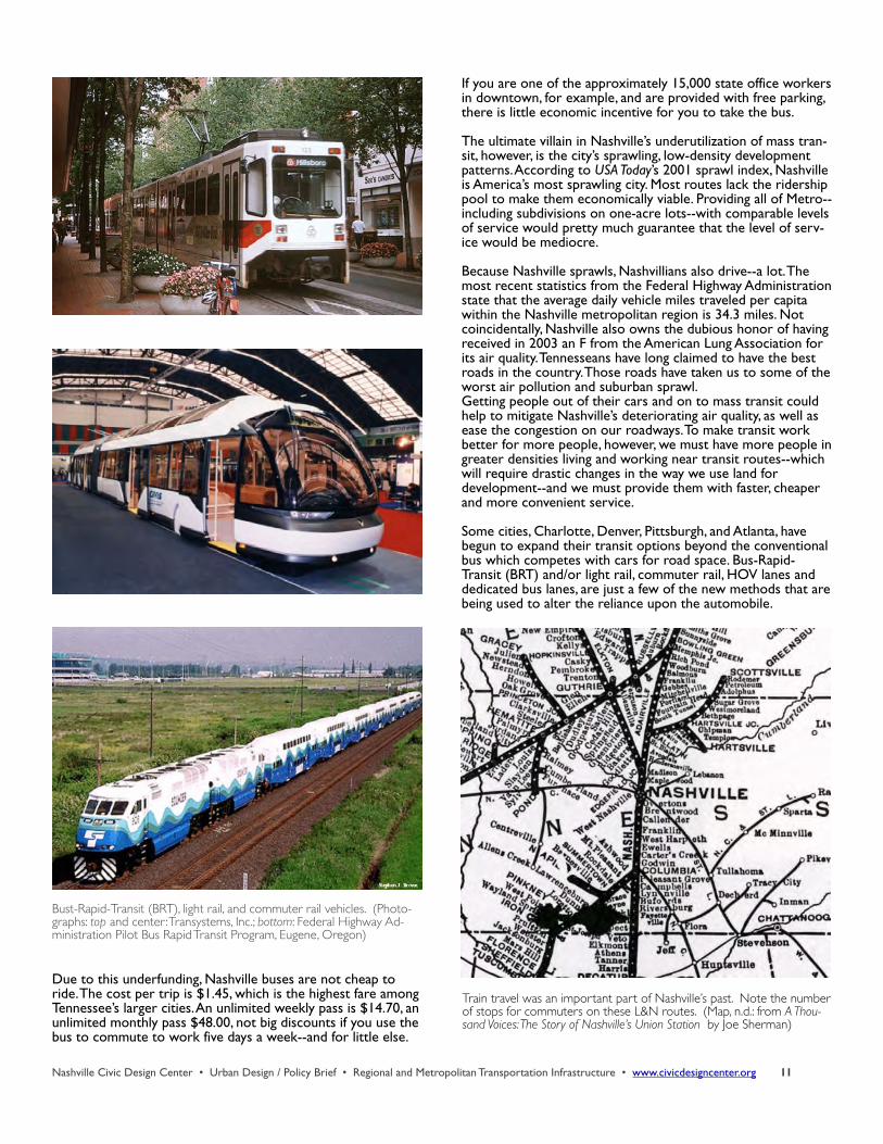
Bust-Rapid-Transit (BRT), light rail, and commuter rail vehicles. (Photo-graphs: top and center : Transystems, Inc.; bottom: Federal Highway Ad-ministration Pilot Bus Rapid Transit Program, Eugene, Oregon)
Train travel was an important part of Nashville’s past. Note the number of stops for commuters on these L&N routes. (Map, n.d.: from A Thou-sand Voices: The Story of Nashville’s Union Station by Joe Sherman)
Reliability, convenience, passenger comfort, and the ability to access major destinations are all key in ensuring that a transit system is used by the public. The Plan of Nashville presents a vision of how transit could work in our city.
Regional Transit
Middle Tennessee once had commuter rail. For the first five decades of the last century, the railroads delivered rural resi-dents to Nashville. As Gillian Fishbach and Suzanne Jackson write in “The Origin and Advancement of Nashville’s Transpor-tation System,” “The city’s retail merchants offered reduced fares on the local trains in an attempt to encourage shopping trips to downtown Nashville. The shoppers boarded the trains in small, rural towns, or at flag stops along the routes.” The service was discontinued in 1956, as the automobile became the mode of choice for middle distance travel.The Regional Transit Authority has a blueprint for returning commuter rail to Middle Tennessee. RTA has plans to develop five routes to link satellite cities to Nashville. These routes could expand to become intercity lines as well.
Commuter rail will provide an additional layer of regional mobility. The lines have the potential to relieve traffic congestion, as well as supply passengers, both commuters and visitors, with a distinctive way to arrive in the city.
Take the Greenway
For thousands of years, the Natchez Trace and similar footpaths served as the pri-mary transportation net-work of Middle Tennessee. The region’s history began with the foot traffic of the Native Americans, who es-tablished an extensive system of trails in order to trade wares and facilitate commu-nication among the various tribes. Metro Nashville’s greenways master plan re-vives this ancient tradition.
As green corridors linking the public parks scattered throughout the county, the greenways are commonly perceived as primarily rec-reational, providing opportu-nities for walking, running, bicycling and other forms of exercise while enjoying Na-ture close to home. But the greenways system is also in-tended to serve as part of our transportation infrastructure, pro-viding non-automotive routes be
tween home and work, and other destinations. The master plan envisions the potential for 210 miles of greenways in Davidson County, linking the far flung suburbs--and the counties sur-rounding Davidson--with the traditional neighborhoods and the urban core.
Integrating the trails with mass transit, by locating bus stops near greenways and adding bike racks to buses, will enhance the connectivity of the transportation system and provide al-ternatives to travel by car. Bike and pedestrian modes of travel produce no air or noise pollution, decrease automotive traffic congestion, alleviate parking demand, improve our health, and save energy and tax dollars. These modes are most effectively utilized in areas of dense and mixed land use, a form of devel-opment advocated by the Plan of Nashville. As a transportation alternative to the automobile, greenways are, therefore, a cru-cial component of the Plan.
Nashville Civic Design Center • Urban Design / Policy Brief • Regional and Metropolitan Transportation Infrastructure • www.civicdesigncenter.org 12
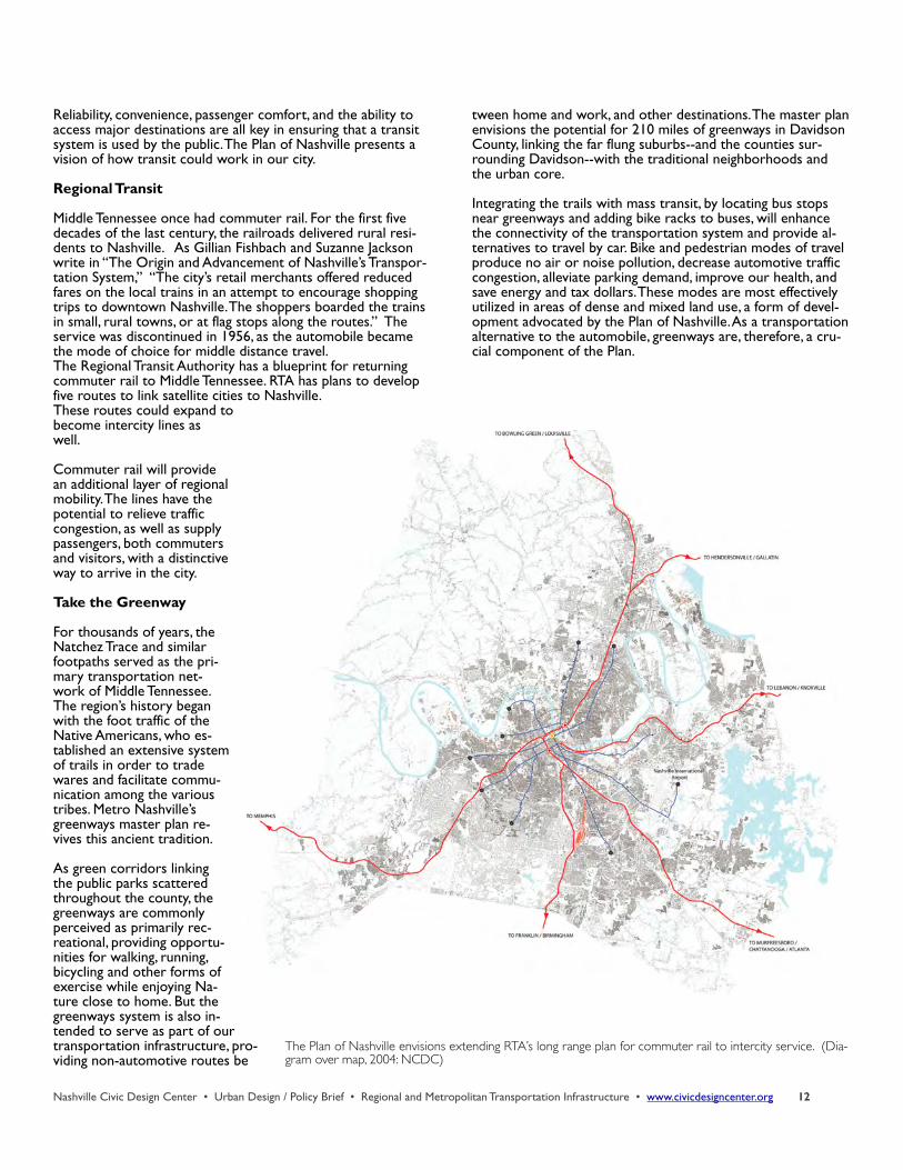
The Plan of Nashville envisions extending RTA’s long range plan for commuter rail to intercity service. (Dia-gram over map, 2004: NCDC)
Conclusion
“We want a Nashville scaled for humans, not cars.” Sue Mulcahy, community workshop participant
The Model Transportation Plan is a vision, made by planners and citizens in collaboration, of a city freed from the noose of its highways. In the plan, Nashville is a city entered along tree-lined boulevards, a place where you can leave home without a car, and where those without cars are more equal members of society.
The social costs of a drive-everywhere culture are high. Chief among them are the loss of independence for children and the elderly--and for the high-mileage moms who are forced to serve as chauffeurs. When Mom is not available, explains MPO coordinator Jeanne Stevens, “we have the real costs of social service van programs which are inefficient and expensive to operate when compared with a regular transit system. It would be a much smarter use of the tax dollar to build cities in a sen-sible fashion.”
We are also becoming aware of the health costs embedded in our current transportation infrastructure. The roads we build have a huge effect on how much we travel. People who live in areas that contain a tight grid of streets and a mixture of land uses walk more, use transit more, and take half as many auto-mobile trips compared to those who live in typical outer-edge suburbs. Maximizing choice and mobility starts with the pedes-trian because every trip begins and ends with walking. Con-necting communities, and enhancing the pedestrian environ-ment, attack the issues of declining levels of personal exercise and growing obesity, as well as mitigating our deteriorating air quality.
For several years the American Lung Association has ranked Nashville as among the top 25 cities with the dirtiest air. “More Highways, More Pollution,” a 2004 study by the U.S. Public In-terest Research Group, states that Nashville ranks second in the nation in highway capacity, and third in the number of miles driven per capita. Not coincidentally, the report found that Nashville leads the nation in pollution from cars and trucks per capita. Poor air quality contributes to asthma attacks, lung can-cer and heart disease.
For too long Nashville has sacrificed its downtown and tradi-tional neighborhoods to the cause of high speeds for commut-ers in the far-flung suburbs, and long distance travelers and truckers.
From The Plan of Nashville: Avenues to a Great City.Vanderbilt University Press (Nashville) 2005.
Nashville Civic Design Center • Urban Design / Policy Brief • Regional and Metropolitan Transportation Infrastructure • www.civicdesigncenter.org 13
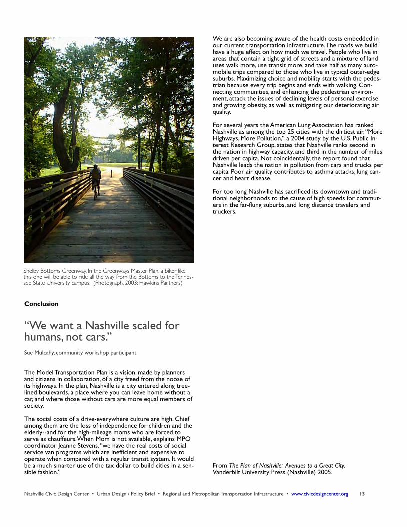
Shelby Bottoms Greenway. In the Greenways Master Plan, a biker like this one will be able to ride all the way from the Bottoms to the Tennes-see State University campus. (Photograph, 2003: Hawkins Partners)