Embed Size (px)
Citation preview
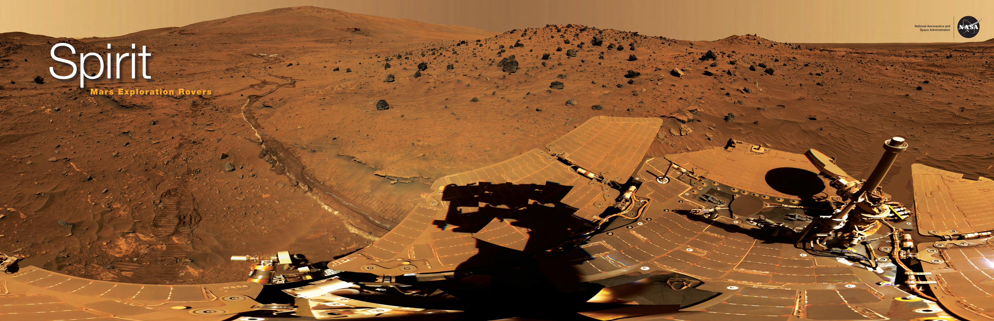
SpiritMars Exploration Rovers
National Aeronautics andSpace Administration
Tracks of dissolved minerals
Pictures from Opportunity’s panoramic camera and microscopic imager reveal that “El Capitan” is thoroughly pocked with indentations about a centimeter (0.4 inch) long and one-fourth or less that wide, with apparently random orientations. This distinctive texture is familiar to geologists as the sites where crystals of salt minerals form within rocks that sit in briny water. When the crystals later disappear, either by erosion or by dissolving in water that is less salty, the voids left behind are called vugs. In this case, the vugs conform to the geometry of possible former minerals.
On the front: Scraping up clues
Spirit’s stuck right front wheel scraped a trench in the Mars surface soil, revealing light-toned material below. These minerals give clues about Mars’ watery past. Spirit made this panorama image over 166 sols (Martian days) in 2006 while wintering on a hill in Gusev Crater.
Spirit’s Sols 814–980 (04/18/2006–10/05/2006)NASA/JPL-Caltech/Cornell Univ./Arizona State Univ.
NASA
/JPL
/Cor
nell
Unive
rsity
Signs of water
JPL 400-1527 02/13
National Aeronautics and Space Administration
Jet Propulsion LaboratoryCalifornia Institute of TechnologyPasadena, California
www.nasa.gov
More information
For more about the Mars Exploration Rovers, NASA’s other Mars missions, and more Mars images and discoveries, visit the following websites:
http://mars.jpl.nasa.gov
http://marsrovers.jpl.nasa.gov
http://photojournal.jpl.nasa.gov/targetFamily/Mars
http://mars.jpl.nasa.gov/science
Spirit examines its surroundings
The 360-degree view on the front of this poster is called the “McMurdo” panorama, captured by the panoramic camera (Pancam) on NASA’s Mars Exploration Rover Spirit. From April through October 2006, Spirit stayed on a small hill known as “Low Ridge” within its Gusev Crater southern hemisphere landing site. The rover’s position tilted its solar panels toward the Sun to maintain enough solar power for Spirit to continue making scientific observations throughout the winter.
The Pancam began shooting component images of this panora-ma during Spirit’s 814th Martian day, or sol (April 18, 2006), and completed it on Sol 980 (October 5, 2006).
Many dark, porous-textured volcanic rocks surround the rover. Left of center, tracks and a trench dug by Spirit’s right-front wheel, which could no longer rotate, exposed bright underlying material. This bright material is evidence of sulfur-rich salty
minerals in the sub-surface, providing clues about the wa-tery past of this part of Gusev Crater.
This “natural color” view is the rover team’s best estimate of what the scene would look like if we were there and
able to see it with our own eyes. It is presented as a cylindrical projection.
Spirit completed its three-month prime mission on Mars in April 2004, then continued operating in bonus extended mis-sions into March 2010, when it ceased communicating.
The mission objectives of the Mars Exploration Rovers were to determine the climatic and geologic history of two sites on Mars with evidence of past, persistent water activity that may have supported microbial life. Although there is always more to learn, the rovers met all mission objectives in their first 90 days, and went on for years gathering valuable information and awe- inspiring images, and making many more scientific discoveries in the process.
In its frozen state, water on Mars has long been obvious, even from Earth. Our telescopes show ice on the surface near the poles. Other spacecraft have discovered ice beneath Mars’ surface. Sometimes the ice melts and makes dark gullies on the sloping sides of craters and hills, visible from Mars orbiters.
However, many other clues point to a great deal more liquid water in Mars’ distant past. Evidence points to lakes, perhaps even an ocean. Liquid water has little chance on present-day Mars. It is too cold and the atmosphere is too thin. Mars’ magnetic field is too weak now to provide much protection of its atmosphere from the solar wind, but early in its existence, Mars had a stronger magnetosphere. What changed to make the water disappear? Did Mars ever support life? These questions remain for future investigation.
For now, let’s look at some of the close-up evidence of copious ancient water discovered by the Mars Exploration rovers, Spirit and Opportunity.
History and water leave salts behind
Salts are the products of an acid combining with a base (or alkali). The result is a neutral substance and (usually) water. The chemical reactions that produce salts require that the components come together in a water solution. From Spirit’s and Opportunity’s findings, salts are abundant on Mars.
Spirit’s Sol 1,202 (05/21/2007): NASA/JPL-Caltech/Cornell
For example, bright soil similar to that uncovered by Spirit’s dragging wheel on the panorama was previously confirmed by Spirit’s instruments to have a salty chemistry dominated by iron-bearing sulfates. Another example (above) of light-colored soil was found to be predominantly silica. These two minerals share a likely origin in water. While sulfates can form in several ways, water is involved in most. The deposits of nearly pure silica in Gusev Crater, Spirit’s landing site, may have formed when volcanic steam or hot water (or maybe both) percolated through the ground. Such deposits are found around hydrothermal vents like those in Yellowstone National Park and are important for understanding past habitability of Mars because hydrothermal environments on Earth support thriving microbial ecosystems.
Blueberries: Minerals that form in acidic water
Opportunity discovered small, spherical bluish pebbles early in its mission. They were nicknamed “blueberries.” Sometimes they are loosely scattered across the surface; other times, they are anchored within individual rock layers. After weeks of meticulous measurements, Opportunity demonstrated that the spheres consisted primarily of the mineral hematite. On Earth, hematite generally—though not always—forms in water. Water provides the oxygen atoms that bind with iron atoms in the mineral. On Mars, it appeared possible that groundwater carrying dissolved iron had percolated through the sandstone to form the tiny spheres.
In a rock outcrop called “El Capitan,” Opportunity found, in addition to blueberries, another iron mineral called jarosite. Both hematite and jarosite form in acidic water.
Opportunity’s Sol 13 (02/06/2004): NASA/JPL/USGS
Opportunity’s Sol 28 (02/21 /2004): NASA/JPL/USGS
Mössbauer spectrum of El Capitan, Meridiani Planum. Jarosite: (K, Na, X+1)Fe3(SO
4)(OH)
6
Inte
nsity
Velocity
0
The spectrum below, made by Opportunity’s Mössbauer Spectrometer, shows iron-bearing jarosite in the “El Capitan” rocky outcrop. The pair of yellow peaks specifically indicates jarosite, which contains water in the form of hydroxyl as a part of its structure. These data indicate that water-driven processes exist on Mars. The spectrum also shows a magnetic phase (blue), attributed to an iron-oxide mineral; a silicate phase (green), indicative of minerals containing double-ionized iron (Fe2+); and a third phase (red) of minerals with triple-ionized iron (Fe3+).
Opportunity’s Sol 28 (02/29/2004): NASA/JPL/USGS
Carbonates formed in neutral water
A set of outcrops collectively called “Comanche,” which Spirit discovered and studied in December 2005, also appear to have minerals that formed in neutral water. Spirit used its Mössbauer Spectrometer, Miniature Thermal Emission Spectrometer, and Alpha Particle X-Ray Spectrometer to examine targets on the outcrop. In 2010, scientists using data from all three spectrometers reported that about one-fourth of the composition of Comanche is magnesium iron carbonate. That concentration is 10 times higher than for any previously identified carbonate in a Martian rock.
Carbonates originate in wet, near-neutral conditions, but dissolve in acid. The find at Comanche is the first unambiguous evidence from either Spirit or its twin, Opportunity, for a past Martian environment that may have been more favorable to life than the wet but acidic conditions indicated by the rovers’ earlier finds.
Clays formed in neutral water
In Endeavour Crater, Opportunity is searching for clay-bearing rocks that show up in spectral images from orbit. Unlike the previous sulfate minerals the rover found, which were formed by the mixture of minerals and acidic water, Martian clays such as in the image below formed in neutral water—water that could be fit for human consumption. Sulfates form under very acidic conditions. Even even though water is present, if it’s very acidic, it would be very challenging as a place for life to take hold. However, if the water is neutral rather than acidic, then the environment is more likely suitable for life.
A watery past
According to the data collected and images taken by rovers Spirit and Opportunity, scientists conclude that Mars at one time had abundant water. It may have had lakes or even an ocean. The chemical analyses performed using the Miniature Thermal Emission Spectrometer (Mini-TES), the Alpha Particle X-ray Spectrometer (APXS), and the Mössbauer Spectrometer show a chemistry consistent with a watery environment. The structures and formations examined in the images taken by the Pancam and the Microscopic Imager show deposition, morphology, and erosion patterns also consistent with a watery, airy environment. Much of the data remain to be analyzed and correlated, but Mars scientists are now confident that further studies will only reinforce the conclusion of a watery ancient Mars.
Layer of gypsum
Endeavour Crater is about 4 billion years old and 22 kilometers (14 miles) in diameter. The impact that blasted out the crater left a jumble of fused-together rock fragments around the rim. In a chunk brought to the surface by a later, much smaller impact into the rim, Opportunity found evidence that the original impact released heated, underground water that depos-ited zinc in that rock. Later after the impact, cool water flowed through cracks in the ground near the edge of the crater and deposited veins of the mineral gypsum. Gypsum is the most common sulfate mineral on Earth, often left behind after water has evaporated.
Opportunity’s Sol 3,064 (09/06/2012) NASA/JPL-Caltech/USGS/Cornell Univ./Arizona State Univ.
NASA/JPL-Caltech/Cornell University
Opportunity’s Sol 2,769 (11/07/2011)NASA/JPL-Caltech/Cornell/ASU
These bright mineral veins are different from anything seen previously on Mars, and they tell a clear story of water flowing through cracks in the rocks. From landing until just before reaching the Endeavour rim, Opportunity was driving over sandstone made of sulfate grains that had been deposited by water and later blown around by the wind. These gypsum veins tell us about water that flowed through the rocks in the older rim of Endeavour crater.
Building layers and wearing them away
A portion of the rim of Endurance Crater 10 meters (33 feet) high called “Burns Cliff” contains many layers of rock, some deposited by water and some by wind. On Mars, wind and water have eroded rocks containing minerals and carried pieces of them to their other locations. In Burns Cliff, these grains piled up with bits of volcanic rock and solidified to form sandstone. Many such layers, stacked atop one another and containing minerals that had initially settled as water evaporated, indicate that water was present for a long time. Opportunity also discovered tiny cavities in the rock that are similar in shape and size to rock cavities on Earth that are left behind when certain minerals are dissolved and dispersed by groundwater.
Opportunity discovered centimeter-scale rock layers overlapping and cutting into each other. These erosion patterns are known as cross-beds and are common on Earth. Here, these layers
Opportunity’s Sols 287–294 (11/13–20/2004)NASA/JPL-Caltech/Cornell/USGS
Comanche Outcrops
OutcropAlgonquin
5 m
Cross-bedding on Checkerboard Mesa, Zion National Park, Utah: photo by Daniel Mayer, Wikimedia Commons
have shapes and sizes that indicate water once flowed on the surface of Mars. In “Endurance Crater,” a thick stack of exposed rock layers, some deposited by wind, suggested that water was intermittently present. Rich in the elements sulfur, chlorine, and bromine, many of the minerals studied by Opportunity had settled to the bottom of a body of salty water, known as a brine, to form deposits similar to those seen in salt flats in desert regions on Earth.
Fe3+ phase
Fe2+ silicate
Magnetic phases
Fe3+ Jarosite