Embed Size (px)
Citation preview

NATIONAL HYDROGRAPHIC OFFICE
OF
NATIONAL AQUATIC RESOURCES RESEARCH & DEVELOPMENT AGENCY
SRI LANKA
NATIONAL REPORT
TO THE
16TH NORTH INDIAN OCEAN HYDROGRAPHIC COMMISSION
CHITTAGONG, BANGLADESH
14-16 MARCH 2016

Page 2 of 14
CONTENT
1. INTRODUCTION............................................................................................. 03
2. SURVEYS ..........................................................................................................04
3. NEW CHARTS AND UPDATES.......................................................................05
4. NEW PUBLICATIONS AND UPDATES..........................................................06
5. MARITIME SAFETY INFORMATION (MSI).................................................07
6. S-55......................................................................................................................08
7. CAPACITY BUILDING.....................................................................................10
8. OCEANOGRAPHIC ACTIVITIES....................................................................11
9. OTHER ACTIVITIES.........................................................................................12
10. CONCLUSION..................................................................................................12

Page 3 of 14
1. HYDROGRAPHIC OFFICE/ SERVICE
National Hydrographic Office (NHO) of National Aquatic Resource Research and Development
Agency (NARA) is responsible for the hydrographic surveys under National Charting Program
for the Democratic Socialist Republic of Sri Lanka.
The NARA is the apex national institute vested with the responsibility of carrying out and
coordinating research, development and management activities on the subject of aquatic
resources in Sri Lanka. The NARA is a statutory body duly established by NARA Act of No. 54
of 1981, during the past 30 years NARA conducted numerous scientific studies in the field of
fisheries and aquatic resources. NARA also provides services for development and sustainable
utilization of living and non-living aquatic resources.
Under the NARA, the National Hydrographic Office was established in 1984 and has achieved
steady progress to its present position as a professional national surveying and charting authority
and is accredited to the International Hydrographic Organization (IHO) as the focal point for
Hydrography in Sri Lanka.
The principle service of the NHO is carrying out hydrographic surveys through systematic data
collection of inshore, near shore, and offshore. These activities in the sea cover up to the limit of
Exclusive Economic Zone of Sri Lanka. In addition, hydrographic surveys of Inland water
bodies are carried out. NHO produces and disseminate information in support of maritime
navigation safety and marine environment preservation, defence, exploration, and research &
management plans.

Page 4 of 14
2. SURVEYS
2.1 Coverage of New Surveys
Presently, new surveys are being carried out for coastal and approaches charts.
Index
No.
Name of the Chart Chart No. Scale Remark
01 Approaches to Norochcholai SL113 1:30,000 New Chart
02 Approaches to Kankasanthurai SL114 1:30,000 -do-
03 Weligama to Colombo Chart SL115 1:150,000 -do-
In addition to those new surveys, NHO involved in some custom made bathymetric surveys
according to the client’s requirements. NHO mainly cater consultancy services to local
institutes such as Coast Conservation Department., Sri Lanka Ports Authority, Ceylon Fishery
Harbour Corporation, Sri Lanka Navy, Shell Gas Company, Ceylon Electricity Board and
Ceylon Petroleum Corporation etc.
2.2 VESSELS/ NEW TECHNOLOGIES AND EQUIPMENT
2.2.1 Vessels
RV Samuddrika- Medium Size Survey Vessel
Taranga – Survey Boat
Tharani – Survey Boat
2.1.2 Instruments
RESON Sea Bat 8101 – Multibeam System
DESO 30 duel frequency echo sounder
T196 NEPTUNE SONAR Duel frequency deep water Transducer (Newly purchased)
SES 2000 – Sub Bottom Profiler
Sea Star 8300HP/Omnistar GPS
RESON SVP 40 Sound Velocity Probe
Leica TCR 1202 Robotic Total Station

Page 5 of 14
2.1.3 Softwares
Caris S-57 Composer
Caris Base Editor
Hypack Max 2015
Caris GIS 4.4
Hypack Gold
Leica GEO Office
PDS 200 Multibeam processing software
Arc GIS 9.2 software is being used for the purpose of GIS and Remote Sensing Applications.
2.3 New Technologies
2.3.1 Chart Adequacy
Knowledge gained for find out and to evaluate existing chart adequacy for safety of navigation
and for maintaining the quality of the chart. This procedure was applied to the navigation chart
of Colombo port and was evaluated for the adequacy. This procedure will be applied for other
available charts for future updates and plans.
2.3.2 Derivation of Near Shore Bathymetry Using High Resolution Satellite Imageries
The necessary skills are adapted to derive the shallow water bathymetry by using high resolution
satellite imageries. As we are implementing Marine Spatial Data Infrastructure (MSDI), these
bathymetric data will be utilized for marine science applications.
3. NEW CHARTS AND UPDATES - Nil
3.1 ENCs
NHO has produced two ENC cells of band 4 and 5 for Approaches to Hambanthota and
Hambanthota harbour which has validated by IC-ENC. NHO is planning to convert existing
paper charts to ENC and is willing to do fulfilling the NHO’s obligations to become ENC
producing nation. Currently, according to the bilateral arrangement, UKHO has produced vital
ENC for Sri Lanka.

Page 6 of 14
Intended Nautical chart for Colombo to Weligama
Nautical Chart
3.2 National Paper Charts
The Kankesanthurai harbour is to be developed as the third international harbour after Colombo
and Ruhunu Magampura ports. Therefore, necessary surveys are being conducting for the
production of the Approaches to Kankesanthurai and Kankesanthurai harbour chart.
.
The data acquisition for the gap filling between Colombo to Weligama are being conducted
under National Charting Programme using RV Samuddrika, as existing chart is based on
unsystematic surveys conducted during the period of 1940.
Intended Nautical Chart for Approaches to Kankasanthurai
Nautical Chart

Page 7 of 14
3.3 Problems Encountered
NHO is continuing to develop and facing challenges in capacity building to improve coverage
with new surveys to comply required standards. In particular, early attention should be drown to
development of Multibeam Survey (MBES) capability and the establishment and development of
an Electronic Nautical Chart (ENC) production and maintenance capability.
4. NEW PUBLICATIONS AND UPDATES
NIL
5. MARITIME SAFETY INFORMATION (MSI)
5.1 Existing Infrastructure for Transmission
The point of contact for the NAVAREA VIII coordinator is the Harbour Master at
Colombo port using his direct email address. The GMDSS facilities are not available in
Sri Lanka. Telecommunication Regulatory Commission responsible for the order existing
facilities. At the moment facilities available are VHF system channel 16 Medium
frequency 2182HZS Communication with Bangalore Maritime Earth Satellite Station.
5.2 Problem Encountered
Still no viable project is in progress to establish GMDSS system in Sri Lanka
5.3 Future Plan
1. Director General of Merchant Shipping will be signing a MOU with NHO/NARA and
other relevant stakeholders to develop an overall strategy to ensure that its international
obligations and responsibilities as a flag, port and coastal states are met. Maritime
Coordinating Committee is formulated and meets regularly to discuss the implementation
of IMO instruments. The requirement of establishing coordinated national MSI structure
is given priority in this regard.
2. The proposed structure of the MSI organisation and the flow of information are shown in
the diagram below.

Page 8 of 14
6. S-55
6.1 Survey coverage
Where,
A = percentage which is adequately surveyed
B = percentage which requires re-survey at larger scale or to modern standards.
C = percentage which has never been systematically surveyed.
Depth A B C
<200m 8.6 5 91.4
>200m 2 0 98
6.1.1 Amplifying Information
Entire area under less than 200m depth has to be surveyed due to the effect of tsunami in
the year 2004. Some areas such as main harbour approaches, fishery harbours, lagoons
and near shore passages have been surveyed in large scale with modern standards.
Page 9 of 14
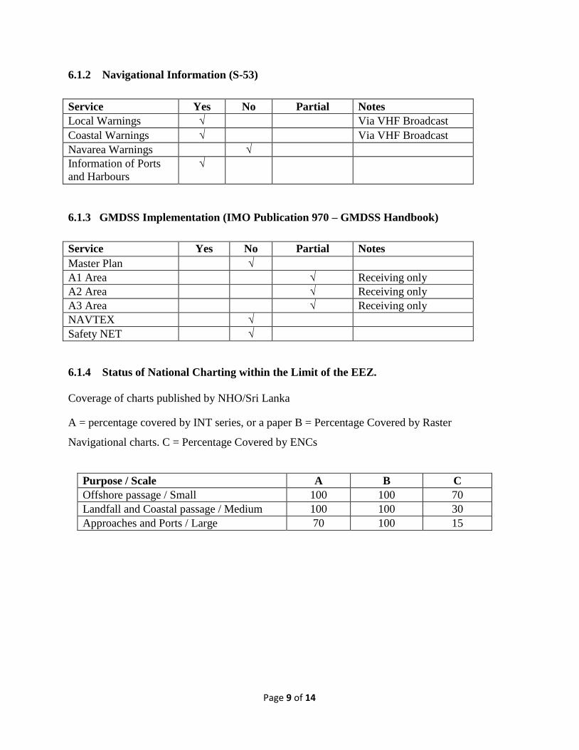
6.1.2 Navigational Information (S-53)
Service Yes No Partial Notes
Local Warnings √ Via VHF Broadcast
Coastal Warnings √ Via VHF Broadcast
Navarea Warnings √
Information of Ports
and Harbours
√
6.1.3 GMDSS Implementation (IMO Publication 970 – GMDSS Handbook)
Service Yes No Partial Notes
Master Plan √
A1 Area √ Receiving only
A2 Area √ Receiving only
A3 Area √ Receiving only
NAVTEX √
Safety NET √
6.1.4 Status of National Charting within the Limit of the EEZ.
Coverage of charts published by NHO/Sri Lanka
A = percentage covered by INT series, or a paper B = Percentage Covered by Raster
Navigational charts. C = Percentage Covered by ENCs
Purpose / Scale A B C
Offshore passage / Small 100 100 70
Landfall and Coastal passage / Medium 100 100 30
Approaches and Ports / Large 70 100 15
Page 10 of 14
7. CAPACITY BUILDING
7.1 Trainings Received – Foreign (2015)
1. IOC/IODE/Ocean Teacher Global Academy: Marine GIS 5 days Training Course,
Kualalampur, Terengganu, Malaysia: One placement
2. IHO/IMO Multibeam 5 days Training course for safety of navigation on Port Operation,
Kualalampur, Malaysia: One Placement
3. Multibeam Data Processing 5 days Training Programme at NARA, Sri Lanka under the
CBP –NIOHC :10 Placement
Local Trainings:
1. Workshop on GNSS Technology Field Observation and Data Processing, NARA
7.2 Training Needed
NHO has identified requirement of urgent training opportunity for senior staff on following areas
1. CAT A on Bathymetry and Ocean Mapping – 02 Placement
2. MBES experience expert to provide a two week in-country training and advisory visit.
3. MSI course in Colombo for Sri Lankan officers.
Further, NHO is interested in following training programmes.
1. Category B in Hydrography
2. Digital Cartography
3. Workshop on Chart Adequacy

Page 11 of 14
8. OCEANOGRAPHIC ACTIVITIES
8.1 Work Done by the Oceanography Division/NARA in 2015
8.1.1 Sea Glider Deployment in the East Coast
During the year 2015, Three Sea gliders were deployed in Baticaloa area in the east coast and
south of Sri Lanka. Two were deployed in August using R/V Roger Revelle US Oceanographic
research vessel. These were recovered and one was deployed November using R/V Samuddrika
NARA research vessel. The glider will measure salinity, temperature, Oxygen profile in the
water column up to thousand-meter water depth. The main objective of this deployment was to
study Sri Lanka Dome which appears at the end of summer monsoon and also behaviour of East
Indian coastal currents around Sri Lanka.
8.1.2 Oceanographic Survey in the East and South of Sri Lanka
Four Oceanographic (Conductivity temperature depth (CTD), vertical micro-structure profiler)
surveys were conducted in east and south of Sri Lanka. Those cruises were done along transects
perpendicular to coast line. In addition to collecting Oceanographic data, zooplankton and
phytoplankton surveys were in the same area.
8.1.3. Installation of Pressure Inverted Echo-sounders (PIEs)
Two pressure inverted echo-sounders were deployed in south of Sri Lanka at the depths of 500m
and 4000ms. The purpose of theses deployments was to understand the extent of East Indian
Coastal Currents (EICC). Data download will be done in August, 2016.
8.1.4 Tide Gauge Network
`Currently three real time transmitting tide gauges covering west, south east and east coasts are
operating in Sri Lanka, which are part of Indian Ocean Tsunami Early Warning System and
GLOSS. Colombo station has equipped with 02 pressure sensors, 02 floating gauges and radar
sensors. It measures sea level every 01 minute and transfers data every 15 minutes via Japanese
Meteorological Satellite (JMA) and MeteoSat. Trincomalee and Kirinda Stations measure sea
levels every 01 minute and transfer data every 15 minutes via MeteoSat. All three stations are
equipped with pressure and radar sensors. Real time data are also in GTS. Future real time
Page 12 of 14
station was planned to be establish in Weligama area as part of technical support to the Global
Sea Level Observing System and Indian Ocean Tsunami Warning System.
9. OTHER ACTIVITIES
9.1 DISASTER PREVENTION
Ocean Observation Centre
The centre is dedicated to provide ocean based disasters information and technical assistance to
all relevant authorities. The centre collaborates with the Ministry of Fisheries and Aquatic
Resources, Ministry of Disaster Management and Human Resources, the Disaster Management
Centre (DMC), the Department of Meteorology in respect of ocean based disasters, early
warning and mitigation of impacts from ocean based natural disasters.
In addition to the ocean based disaster prevention and mitigation activities, the centre gathers and
analyses oceanographic data within our maritime boundaries for other Research and
Development applications such as fisheries, safety navigation, climate and environmental studies
and coastal development planning.
9.2 MSDI PROGRESS
NHO has completed the development of web interface and database system using Geonetwork
and Geoserver for implementing the MSDI. The system is fully facilitated to absorb both raster
and vector geospatial data under ISO19139 standard.
10. CONCLUSION
With the new capacity, NHO is striving to carryout surveys for coastal chart productions amidst
budgetary constrain to provide updated nautical information for marines and keep in phase with
the modern skills such as developing MSDI, developing capacity for ENC production, deriving
shallow water bathymetry by using high resolution satellite imageries and evaluating existing
charts for adequacy.
In this endeavour NHO seeks assistance and co-operation from NIOHC especially for the
capacity building of human resources in NHO.
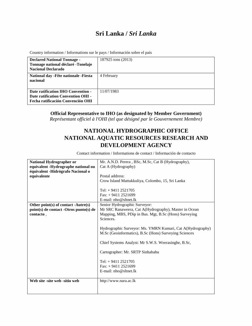
Sri Lanka / Sri Lanka
Country information / Informations sur le pays / Información sobre el país
Declared National Tonnage -
Tonnage national déclaré -Tonelaje
Nacional Declarado
187925 tons (2013)
National day -Fête nationale -Fiesta
nacional
4 February
Date ratification IHO Convention -
Date ratification Convention OHI -
Fecha ratificación Convención OHI
11/07/1983
Official Representative to IHO (as designated by Member Government) Représentant officiel à l'OHI (tel que désigné par le Gouvernement Membre)
NATIONAL HYDROGRAPHIC OFFICE
NATIONAL AQUATIC RESOURCES RESEARCH AND
DEVELOPMENT AGENCY
Contact information / Informations de contact / Información de contacto
National Hydrographer or
equivalent -Hydrographe national ou
équivalent -Hidrógrafo Nacional o
equivalente
Mr. A.N.D. Perera , BSc, M.Sc, Cat B (Hydrography),
Cat A (Hydrography)
Postal address:
Crow Island Mattukkuliya, Colombo, 15, Sri Lanka
Tel: + 9411 2521705
Fax: + 9411 2521699
E-mail: [email protected]
Other point(s) of contact -Autre(s)
point(s) de contact -Otros punto(s) de
contacto ,
Senior Hydrographic Surveyor:
Mr SRC Ranaweera, Cat A(Hydrography), Master in Ocean
Mapping, MBS, PDip in Bus. Mgt, B.Sc (Hons) Surveying
Sciences.
Hydrographic Surveyor: Ms. YMRN Kumari, Cat A(Hydrography)
M.Sc (Geoinformatics), B.Sc (Hons) Surveying Sciences
Chief Systems Analyst: Mr S.W.S. Weerasinghe, B.Sc,
Cartographer: Mr. SRTP Sinhabahu
Tel: + 9411 2521705
Fax: + 9411 2521699
E-mail: [email protected]
Web site -site web -sitio web http://www.nara.ac.lk

Principal functions of the organization
or the department -Attribution
principales de l'organisme ou du
département -Principales funciones de
la Organización o el departamento
• Control and co-ordination of all hydrographic surveying and nautical
charting activities in Sri Lanka.
• Collection, processing and publication of hydrographic data and
nautical information.
• Establishment of standards and procedures for gathering, processing
and display of hydrographic data and nautical information.
• Training of personnel.
Annual operating budget -Budget
annuel -presupuesto anual
45 000 000 ( Rupees )
Total number of staff employed -
Effectifs totaux -Número total de
personal empleado
44
Total number of paper charts published
-Nombre total de cartes papier publiées
-Número total de cartas de papel
publicadas
10
Detail of surveying vessels/ Aircraft -
Détail des bâtiments
hydrographiques/aéronefs -Detalle de
buques hidrográficos/Aeronaves
"RV Samuddrika",
THARANGA-Small Boat
"Bar Reef" -Small Boat
Displacement Commissioning Date Crew
-déplacement -date de mise en service -équipage
-Desplazamiento -Fecha de puesta en servicio -Personal
Other information of interest -Autres
informations utiles -Otra información
de interés
Production of maps on Fishery Resources.
Providing of Hydrographic data for Coastal Zone Management,
Environmental Pollution, Coastal Line Protection, Harbour
Development, Mineral Sand Exploration & Exploitation, etc.
Date of establishment
-Date de mise en place
-Fecha de constitución
March 1984
Top level parent organization
-Organisme mère
- Organización asocieda de nivel superior
National Aquatic Resources Research and
Development Agency under the Ministry of
Fisheries & Ocean Resources
25 MT 2012 14
1992 5
2014 5