Embed Size (px)
Citation preview
1
www.naturalengland.org.uk
28. Vale of YorkSupporting documents
National CharacterArea profile:

IntroductionAs part of Natural England’s responsibilities as set out in the Natural Environment White Paper1, Biodiversity 20202 and the European Landscape Convention3, we are revising profiles for England’s 159 National Character Areas (NCAs). These are areas that share similar landscape characteristics, and which follow natural lines in the landscape rather than administrative boundaries, making them a good decision-making framework for the natural environment.
NCA profiles are guidance documents which can help communities to inform theirdecision-making about the places that they live in and care for. The informationthey contain will support the planning of conservation initiatives at a landscape scale, inform the delivery of Nature Improvement Areas and encourage broader partnership working through Local Nature Partnerships. The profiles will also help to inform choices about how land is managed and can change.
Each profile includes a description of the natural and cultural features that shape our landscapes, how the landscape has changed over time, the current key drivers for ongoing change, and a broad analysis of each area’s characteristics and ecosystem services. Statements of Environmental Opportunity (SEOs) are suggested, which draw on this integrated information. The SEOs offer guidance on the critical issues, which could help to achieve sustainable growth and a more secure environmental future.
NCA profiles are working documents which draw on current evidence andknowledge. We will aim to refresh and update them periodically as newinformation becomes available to us.
We would like to hear how useful the NCA profiles are to you. You can contact theNCA team by emailing [email protected]
National Character Areas map
1 The Natural Choice: Securing the Value of Nature, Defra(2011; URL: www.official-documents.gov.uk/document/cm80/8082/8082.pdf)2 Biodiversity 2020: A Strategy for England’s Wildlife and Ecosystem Services, Defra(2011; URL: www.defra.gov.uk/publications/files/pb13583-biodiversity-strategy-2020-111111.pdf)3 European Landscape Convention, Council of Europe(2000; URL: http://conventions.coe.int/Treaty/en/Treaties/Html/176.htm)
2
28. Vale of YorkSupporting documents
National CharacterArea profile:

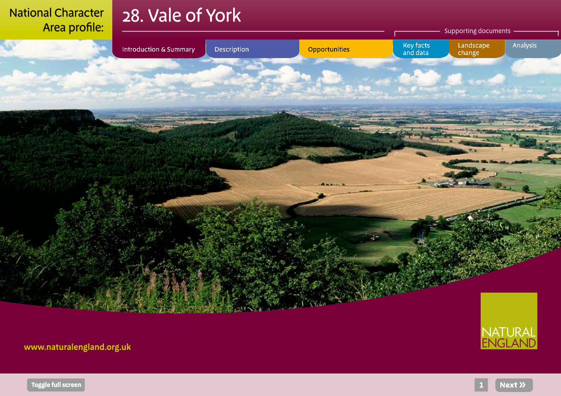
SummaryThe Vale of York is an area of relatively flat, low-lying land surrounded by higher land to the north, east and west. High-quality soils across most of the National Character Area (NCA) mean that arable cultivation is the predominant land use, although some pig and dairy farming takes place in the western parts of the NCA. A key feature of the NCA is the rivers that drain surrounding higher land and run southwards through the Vale on towards the Humber basin. Natural flood plain habitats and associated species are still found within the Lower Derwent Valley (designated as a Special Protection Area, Special Area of Conservation and Ramsar site) although, like other flood plains, this area is threatened due to water quality issues.
The City of York, a settlement that has been an important focus since Roman times, sits at the centre of this NCA. The prominent York Minster can be seen from lower-lying surrounding countryside and, together with the city walls, provides the setting for the historic city.
Food and water provision and the regulation of water flow and water quality are key ecosystem services provided by this NCA. Flooding affects a number of communities within the NCA, as they are within the lower stretches of the river flood plains. More than 7,000 properties are at risk of flooding in York, Bishopthorpe, Haxby and Strensall from the River Ouse catchment.
There are opportunities to restore wetland habitat within river corridors to alleviate fast water flows (for example working with land managers on the River Foss to slow rates of floods that are generated in York4) and aid climate adaptation mitigation. Restoration of river systems will also maintain and improve natural soil fertility for productive agriculture, improve the ecological networks and
strengthen the ability of biodiversity to adapt to current – and future – pressures. A key challenge will be to establish sustainable land management practices that safeguard and strengthen the fertile soils needed for arable cultivation while also providing sustainable income for land managers.
Click map to enlarge; click again to reduce.
4Draft Ouse Catchment Management Plan, Summary Report, Environment Agency (January 2010)
3
28. Vale of YorkSupporting documents
National CharacterArea profile:

Statements of Environmental Opportunity:
■ SEO1: Identify opportunities within the existing agricultural systems to enhance landscape character and create a functioning ecological network to safeguard future food provision, retain soil quality and reduce soil erosion and deliver benefits for biodiversity, carbon storage and climate regulation.
■ SEO 2: Manage and enhance the network of rivers and important wetland habitats within the Vale, increasing the landscape’s ability to naturally and sustainably manage flood and drought risk and provide other ecosystem services while recognising the needs of individual species and habitats and increasing the resilience of wildlife to climate change.
■ SEO 3: Increase the network of species-rich meadows, pastures, fields and hedgerows, ensuring that they and the wider farmed environment are managed to reduce rates of diffuse pollution and improve water quality. Extend and enhance heathland sites on areas of sandy soil for the benefit of biodiversity, as well as enhancing the sense of place.
■ SEO 4: Protect the historic and cultural features of the Vale, in particular the traditional settlement patterns of remaining villages and the evidence of previous settlements that provide a strong sense of place.
View across the flat open landscape of the Vale of York from the bordering higher land of the Yorkshire Wolds.
4
28. Vale of YorkSupporting documents
National CharacterArea profile:

DescriptionPhysical and functional links to other NationalCharacter Areas
The Vale of York forms a transitional landscape between the more varied topography and the mixed farming of the Vale of Mowbray to the north and the flat, open land of the Humberhead Levels to the south.
The adjoining elevated areas feature an extensive network of major rivers, with the Derwent rising in the North York Moors and Cleveland Hills National Character Area (NCA) in the north; the Swale, Nidd and Ure in the Yorkshire Dales NCA; and the Wharfe in the Southern Pennines NCA to the west. These watercourses all ultimately flow into the Humber Estuary to the south-east. The Vale of York is an important convergence zone for the upland rivers; they converge into the River Ouse, which starts in the Vale of York. These rivers, and their associated flood plain habitats, provide important corridors for species movement between the Vale and surrounding NCAs. This could become increasingly important as habitats around the Humber are squeezed by the effects of climate change. The settlements in the Vale rely heavily on the water supplied by these rivers.
A network of transport routes radiates from the City of York: York railway station remains an important junction for passengers travelling to the north-east. The A19 runs north–south through the centre of the NCA, with other A roads linking York east–west with other NCAs.
Views of higher ground to the north and east in the Howardian Hills and Yorkshire Wolds, and to some extent the Southern Magnesian Limestone ridge to the west, frame the valley and provide a backdrop to the relatively open and flat landscape of the NCA.
5
Land use is predominantly agricultural, with large arable fields bounded by hedgerows of varying quality and some field boundary trees.
28. Vale of YorkSupporting documents
National CharacterArea profile:

Key characteristics
■ A largely open, flat and low-lying landscape between the higher land of the Southern Magnesian Limestone ridge to the west, the Howardian Hills to the north and the Yorkshire Wolds to the east.
■ Dominantly Triassic solid geology, which is obscured by glacial till, sand, gravel and moraines, with obvious ridges formed by the York and Escrick moraines.
■ Predominantly agricultural land use, with medium- to large-scale arable fields defined by hedgerows (which are often low and intermittent with sparse hedgerow trees) and fences. Large dispersed farmsteads and small villages on higher land are set within a quiet rural landscape.
■ Extensive (mostly cropmark) evidence of bronze-age to Romano-British settlement, especially on the western fringe, for example enclosed and unenclosed farmsteads with hut circles and coaxial field systems.
■ Wetland features dotted through the wider landscape of the NCA, providing stepping stones between wider areas of water-dependent and priority habitat, such as important remnants of ‘ings’ meadows on the river flood plains (traditionally managed by hay-making) and some unimproved and semi-improved meadows and pastures, in particular in the Derwent Ings.
■ Some areas of heathland remaining on poorer sandy soils (for example Strensall, Stockton and Allerthorpe commons), along with small scattered broadleaved woodlands and larger conifer plantations.
■ Parkland associated with country houses, with tree clumps, tree belts, avenues and other architectural features adding to the variety of the landscape, for example Rufforth Hall Park, Beningbrough Hall and Bilton Hall.
■ The main urban centre, the City of York, with roads radiating from the city and York Minster forming a prominent landmark and focal point for the Vale.
■ The settlement patterns of the NCA, which broadly follow that of linear villages, with buildings (built with traditional materials of mottled brick and pantile roofs) set back behind wide grass verges and village greens, and dispersed large farmsteads.
6
This farmstead near Escrick is built in the typical red brick and pan-tile roof character of the area.
28. Vale of YorkSupporting documents
National CharacterArea profile:

The many stream courses and drainage channels link with the main rivers that cross the Vale. The flood plains of the rivers Ouse, Derwent, Ure, Nidd and Foss create much of this flat landscape. The National Character Area (NCA) has a wide variety of waterbodies (in terms of size and velocity) within it, making water a key feature of the NCA. The flood plains of the main rivers form a characteristic sight in the area, generally flowing from north-west to south-east. The flood plain of the River Derwent in the Lower Derwent Valley is designated both as a Special Protection Area (SPA) and Special Area of Conservation (SAC) for its internationally important lowland hay meadow habitat and contains a greater area of high-quality examples of this habitat than any other UK site. Traditional
The Vale of York today
The Vale of York is a transitional vale landscape marking the change from the more varied topography and mixed farming of the Vale of Mowbray to the north to the flat, open land of the Humberhead Levels to the south. It is a broad area bounded by the ridge of Magnesian Limestone which rises to the west and by the Howardian Hills and the Yorkshire Wolds to the east. The low ridge of the Escrick Moraine, which trends to the north-east, marks the southern limit and the transition to the Humberhead Levels.
The soils are mainly formed from glacial till, sand and gravel, making them generally fertile. The majority of the land is in arable use, with extensive areas of wheat and root vegetables. Fields are medium to large in size and enclosure is by low, flailed, often intermittent hedges, with few hedgerow trees. This gives the landscape a generally large-scale, open, well-tended character, where production is the main emphasis of land management. Much of the Vale of York is a working agricultural landscape but the settlement also contributes to its character. The City of York itself has a dominant influence and the tower of the minster, built from stone brought from the Southern Magnesian Limestone ridge to the west, is visible for miles around. The city, enclosed by the historic city walls, is very popular with tourists, bringing visitors through the city gates to attractions that build on the historic importance of the area.
The flat farmland is dotted with solid brick farmsteads and large villages, such as Upper and Nether Poppleton and Haxby to the north and Bishopthorpe and Copmanthorpe to the east, which exhibit the typical linear vale form of mottled brick houses with pantile roofs facing each other on either side of a main street. They are in themselves important features of the landscape and provide a special focus of interest.
The York Minster, built on top of the York Moraine, sits above the surrounding Vale and dominates views for miles around.
7
28. Vale of YorkSupporting documents
National CharacterArea profile:

management has maintained the mosaic of habitats within the valley and it is this variation that helps to support important species such as Bewick’s swan,5 ruff6 and golden plover.7 In winter the valley supports an internationally important assemblage of wading birds, including European teal and Eurasian wigeon. In the wider landscape, wetland features such as small field ponds, old brick ponds, wet heathland, valley mires (for example Askham Bog), fens and swamps (for example in the Lower Derwent Valley), fen meadows (also in the Lower Derwent Valley) and drainage dykes interspersed through the agricultural areas with other patches of semi-natural habitats provide stepping stones between designated areas and patches of semi-natural habitat.
Variations in landscape character come from subtle changes in soils, topography and land cover. Low ridges of sand and gravel, deposited as moraines or eskers as the glaciers of the last ice age retreated, rise above the flat plain in places, creating a more pronounced ridge and valley landform. Where there are dry, sandy soils,
especially around York to the north, east and south, there are remnants of historic heathland and ancient semi-natural woodlands. Because of the low fertility and acidity of the soils, many of these areas have been planted with coniferous woods, usually of Scots pine. Examples of these features include Strensall, Stockton and Allerthorpe commons. Plantations, woodlands and heaths give a different character to these parts of the Vale, with the woodland edges creating a greater feeling of enclosure and forming wooded horizons.
Parkland associated with country houses is also a feature of this NCA, and the tree clumps, tree belts, avenues and other architectural features all add to the variety of the landscape. Examples include Rufforth Hall Park, Beningbrough Hall and Bilton Hall.
Access within the wider NCA is limited, but the Way of the Roses cycle route, which passes east–west as it links Morecambe to Bridlington, and the Yorkshire Wolds Way, which enters the NCA in the south-eastern corner, are notable long-distance routes that pass through the area.
Wet heathland habitat that remains at Strensall Common supports important species and helps give this part of the NCA a different character
5 0.7 per cent of the population of Great Britain, 619 per cent of the population of Great Britain72.4 per cent of the population of Great Britain
Internationally important lowland hay meadow habitat being managed in the Lower Derwent Valley National Nature Reserve. Traditional management techniques help the habitat support important assemblages of bird species.
8
28. Vale of YorkSupporting documents
National CharacterArea profile:

The landscape through time
The solid geology of the Vale of York comprises Triassic sandstone and mudstone and Lower Jurassic mudstone and is completely cloaked by varied superficial deposits. The deposits include glacial till, which forms a marked bench in the east, and sand and gravel, as well as two moraines that curve eastwards across the NCA. The York Moraine forms a curving ridge that extends from York to Sand Hutton, while the Escrick Moraine is evident about 8 km to the south, formed at the point at which the ice met the large proglacial Humber Lake in the south of the NCA. Trapped between moraine ridges a series of (possibly contemporary) glacial lakes developed to the north of the Escrick Moraine as the ice sheet advanced and retreated. When the lakes drained, they left a sequence of lake clays, silts and sands over much of the NCA. Subsequent aeolian (desert) reworking of these sands has led to the accumulation of thick sequences of wind-blown sand along the eastern margins of the NCA.
The main rivers and streams also laid down river alluvium consisting of clay, silt and sand. These lacustrine and alluvial deposits provide good loamy soils that support human settlement and food production. The impact of the river systems has influenced the locations at which settlements have developed, with evidence of early settlements on higher outcrops and later settlements centred on river crossings. The cool climate and increased rainfall during the Bronze Age meant that lowland wetlands enlarged and spread across the south of the Vale, making it less habitable. Evidence of early human settlement in the Vale of York (mostly in the western and eastern fringes) comes from the discovery of stone tools and flint scatters representative of Mesolithic and Neolithic activity, and rapiers and axes from the middle Bronze Age.
View south-east down the River Ouse from just upstream of the small village of Overton, near Nether Poppleton, York.
The Romans had a large influence on the character of the Vale of York, defining some of the settlement and infrastructure pattern that can still be seen today, particularly the network of roads radiating from York. The building of a legionary fortress on the York Moraine at Eboracum (now York) was the beginning of permanent civilian settlement in the area. York has continued to be the central focus of the area since this time and developed from a frontier town that resisted local tribes to a strategically important staging post to the north. York Minster was founded in 627 on the site of the Roman fortress and has been destroyed and rebuilt a number of times since, with the remaining Gothic structure started in 1230 and finished and consecrated in 1472. The surrounding productive and wealth-generating landscape meant that the Bishop of York rose to be the second highest office in the Church of England and that York became a major ecclesiastical centre.
9
28. Vale of YorkSupporting documents
National CharacterArea profile:
Historically there has been a predominance of cattle rearing and dairying to the west, and horse breeding to the east, with livestock from the hills in surrounding NCAs brought to the lush vale grasslands for fattening. The rich grasslands of the flood plains supported sheep grazing and increased York’s importance in the wool industry. Stud farms increased around York in the 18th and 19th centuries, probably as a result of the formalisation of a racetrack in York and the move to its current location. The racecourse continues to attract a large number of visitors to the area.
In the 16th century the Vale began to feature extensive areas of parkland and designed landscapes, such as the deer parks at Sheriff Hutton and Beningbrough Hall. The dissolution of the monasteries and ‘gifting’ of land to nobles also saw the establishment of notable country houses and estates in the NCA. Until the 17th century the Royal Forest of Galtres contained some larger areas of woodland in the north of the Vale of York. The forest at this time extended further into North Yorkshire, although it had been declining since its peak in the 12th century.
There are a number of outlying military camps surrounding York, such as at Clifton Moor and Monks Cross, which further indicate the impact of the Romans on the landscape. New evidence from this period continues to be revealed, including sites at Sutton on Derwent and at Hayton. Roman settlement also introduced management to the river flood plains to increase agricultural productivity, marking the start of the decline in many flood plain habitats.
During the period that the Vikings held the north of England in the late ninth and early tenth centuries they established Jorvik (York) as their capital of Northumbria. In 954 this Viking kingdom was absorbed into the rest of England, although there were various attempts throughout the early 11th century from Danish Vikings to retake the kingdom. In 1066 the Battle of Stamford Bridge was fought between King Harold and a Norwegian force bolstered by Northumbrian support, which weakened Harold’s army ahead of the Battle of Hastings.
Mixed agriculture has dominated the area since medieval times. Following the Norman conquest, King William undertook a number of campaigns to break future threats to the crown from the north, known as the ‘harrying of the north’. The destruction of towns, villages and agricultural assets and the reassignment of land to favourable nobles led to a strong trend of nucleated settlement in planned villages; manors and estates established within the wider landscape during the late 11th–13th centuries still exist today. Moated sites are a particular feature of this landscape, such as examples at Appleton Roebuck, Pocklington and Barmby Moor. Many survive today as earthworks, cropmarks and soilmarks, and the ditches associated with these sites are still waterlogged in places, providing essential information on past land use and activity. Some villages retain former ridge and furrow and hedges following lines of curved strips, and the area is characterised by a high proportion of planned enclosure by Parliamentary Act between the mid-18th century and 1815.
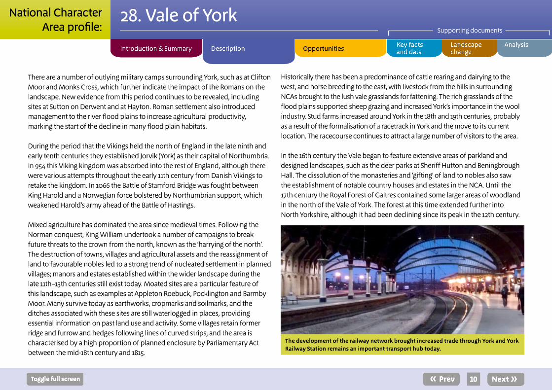
The development of the railway network brought increased trade through York and York Railway Station remains an important transport hub today.
10
28. Vale of YorkSupporting documents
National CharacterArea profile:

Woodland within the Vale continued to become scattered and piecemeal until large areas of sandy soil were planted with conifer plantations in the late 19th century, aided by the enclosure of common land on sandy soils.
In earlier centuries wheat and rye were the main crops grown, and large areas of grassland remained. Root crops such as potatoes and carrots were introduced early in the 20th century and remain common today. Noticeable intensification of agriculture occurred during the Second World War and continued in the decades afterwards. Throughout the 20th century sugar beet was a common crop around the City of York, as farmers supplied the York sugar beet factory. Since its closure in 2007, sugar beet production has been replaced by a range of other crops, notably oil seed rape.
Ecosystem services The Vale of York NCA provides a wide range of benefits to society. Each is derived from the attributes and processes (both natural and cultural features) within the area. These benefits are known collectively as ‘ecosystem services’. The predominant services are summarised below. Further information on ecosystem services provided in the Vale of York NCA is contained in the ‘Analysis’ section of this document.
Provisioning services (food, fibre and water supply) ■ Food provision: The Vale of York is part of a large swathe of agricultural land starting in the Vale of Mowbray in the north and running down to the Humberhead Levels in the south. Glacial lake deposits have helped to produce high grade soils (54 per cent Grade 3 and 28 per cent Grade 2), and historic drainage has helped to make the area ideal for arable farming, with 82 per cent of the total area in cultivation. Most holdings are given
over to cereals and root crops, such as potatoes and carrots, with smaller proportions of mixed cropping, lowland cattle, sheep, pigs and poultry, as well as some dairy.
■ Water availability: The Vale of York provides a large amount of water for local communities and for those as far away as Sheffield, both from underground aquifers and from abstraction from the rivers running through the NCA. The western part of the NCA overlies a Permo-Triassic sandstone aquifer (the Sherwood Sandstone aquifer, which is a major source of drinking water for the region). Rainfall is low in the NCA, and due to existing high levels of demand on these aquifers they currently have no water available for additional abstraction (except for a small area in the south-eastern corner).
Food production is an important ecosystem service within the Vale and root crops are common. There are many opportunities within agricultural land management to improve the ecosystem services provided by these cultivated areas.
11
28. Vale of YorkSupporting documents
National CharacterArea profile:

Regulating services (water purification, air quality maintenance and climate regulation)
■ Climate regulation: A low proportion of carbon is stored within the first soil horizon (0–5 per cent) across most of the NCA, although there are pockets of higher soil carbon content which coincide with the heaths at Allerthorpe and Strensall as well as some areas underlying the south-western part of York.
■ Regulating soil erosion: Regulation of soil erosion is currently low, although almost half the soils in the NCA are not susceptible to erosion. The light, sandy soils across much of the Vale are prone to soil erosion, with wind erosion an increasing concern in this area. Intensive agricultural practices increase the risk of erosion, especially after heavy rains or in areas of poorly draining soil. The risks are also enhanced on the steeper slopes where bare or cultivated soil is exposed and where continuous cultivation of crops such as potatoes has reduced organic levels in the soil.
Flooding, as seen here where the River Derwent has overtopped the floodbank, is a concern within the Vale and regulation of water flow a key ecosystem service that can be provided through natural management of the rivers and floodplains.
■ Regulating soil quality: Soil quality in its current state and management enables highly productive agriculture to prevail across the NCA. The value of slowly permeable, seasonally wet, slightly acidic but base-rich loamy and clayey soils (which cover 37 per cent of the NCA) could decrease, as such soils are susceptible to compaction and can be easily damaged when wet.
■ Regulating water quality: Groundwater quality in this NCA is good in the east but poor in the west. All the rivers that have been assessed are of good chemical quality, including the rivers Ure and Ouse in the west. The ecological quality of the rivers in the area is classed as good or moderate, although a small stretch of river in the south-western corner associated with tributaries of the River Wharfe is classed as poor, as is the River Foss. Much of the central and northern parts of the NCA fall within the Yorkshire Ouse, Nidd and Swale catchment sensitive farming priority catchment, while parts of the south-east fall within the Yorkshire Derwent catchment sensitive farming priority catchment. (The catchment sensitive farming project offers advice and training to farmers and land managers in priority catchment areas to enable them to take voluntary action to reduce their high diffuse water pollution from agriculture to protect waterbodies and the environment.)
■ Regulating water flow (flooding): The NCA includes a large number of rivers that drain surrounding areas; high levels of drainage within the natural flood plains have increased the pressure on the river system, leading to a long history of flooding. The amount and speed of water arriving in the NCA are dependent on the condition of surrounding upland areas where the river headlands are located; land within the NCA is heavily drained, so more water arriving more quickly from surrounding areas increases flood risk locally. There is potential for a more naturalised regulation of flood waters in this NCA, although the system currently runs at capacity, especially along the River Ouse. Many sections of
12
28. Vale of YorkSupporting documents
National CharacterArea profile:

river have been canalised, disengaging them from their flood plains. These rivers cannot naturally deposit silt within flood plains, and build-up in the channels can exacerbate flooding problems by limiting the storage capacity of the waterbody. Restoration of washlands has helped to alleviate some of the flooding pressures in the lower parts of the Vale, for example to the north of the City of York.
Cultural services (inspiration, education and wellbeing) ■ Sense of place/inspiration: Sense of place and cultural heritage services are dominated by the arable landscape and the major rivers that dissect the flat, open landscape. Semi-natural features such as remnant heathlands, ponds, wetlands, grasslands, hedges, hedgerow trees, copses, shelterbelts, remnants of ancient semi-natural woodlands and commons are scattered through the area, as are historic features such as irregular fields, Romano-British settlements, parkland associated with country houses, distinctive linear villages, isolated farmsteads, masonry bridges and vernacular buildings of traditional materials of mottled brick and pantile roofs. Within the walls of the City of York the historic buildings and minster provide a strong sense of place.
■ Sense of history: There is a great sense of history throughout the NCA and the landscape is littered with evidence of settlements from Roman times. History within the Vale has been dominated by the continuous mixed land use of lush river meadow pasture and productive, versatile soils. Villages within this landscape have a structure relating to post-Norman settlement and planning but also reveal subsequent medieval redevelopment and modification. The history of enclosure, management and cultivation of the land is evident in the landscape but is being eroded due to imbalance in activity (for example there is more arable land and less pasture now). The City of York provides a central focus for historic character and entertainment, education and recreation in the Vale, attracting local, national and international visitors. The development of the city through different periods can be experienced within the city walls.
■ Recreation: Recreation and access are supported by the Yorkshire Wolds Way and Ebor Way long-distance routes, the network of footpaths (816 km at a density of 0.8 km per km2) and small areas of open access land (0.28 per cent of the area is open access land). The relatively little open access land in this NCA reflects the high levels of private land ownership; the areas and old estates that are open to the public provide good opportunities for recreation. Within the City of York itself opportunities exist for recreation focused around historically important sites and themes. New developments provide opportunities to improve access to, and recreation within, a wider number of sites and areas and to ensure that the public realm remains accessible and does not become privatised.
■ Biodiversity: The remaining heathland sites at Strensall Common and Allerthorpe Common and the river flood plain of the Lower Derwent Valley are designated as Sites of Special Scientific Interest for their nature conservation value. The Lower Derwent Valley Special Protection Area/Special Area of Conservation/Ramsar site is one of the most important traditionally managed, species-rich alluvial flood meadow habitats remaining in the UK. All the rivers and their corridors that flow through the Vale are important features for biodiversity, and reconnecting the rivers with the flood plain along these corridors and decreasing external pressures on them will have benefits for biodiversity.
Strensall Common and Allerthorpe Common feature the best remaining examples of heathland habitat in the NCA, supporting a number of rare invertebrates and birds.
Patches of semi-natural habitat and small features such as ponds, ditches, hedgerows and trees provide permeability to the wider landscape for biodiversity and act as important stepping stones through the agricultural areas. The NCA is a priority area for action to support farmland birds, species of which are declining.
13
28. Vale of YorkSupporting documents
National CharacterArea profile:

SEO 1: Identify opportunities within the existing agricultural systems to enhance landscape character and create a functioning ecological network to safeguard future food provision, retain soil quality and reduce soil erosion and deliver benefits for biodiversity, carbon storage and climate regulation.
For example, by: ■ Managing, restoring and thickening hedgerows, as well as replacing and planting new hedgerow trees to create species-rich hedgerows. This will help to create a network across the agricultural landscape which enhances sense of place and creates wildlife corridors.
■ Encouraging sustainable agricultural practices that enhance the delivery of an increased range of ecosystem services from the land to increase soil quality, reduce soil erosion and improve water quality and management. Practices such as increased organic matter input, undersowing and inclusion of grassland into rotation will preserve the quality of the soils for future food production.
■ Restoring field ponds and other features such as ditches, dykes, small woodlands and shelterbelts, to ensure that they are being adequately managed for their contribution to the landscape and biodiversity. This will help to maximise their contribution to the permeability of the landscape and their role as stepping stones connecting larger areas of habitat.
■ Encouraging increased winter water storage in the agricultural sector to help it to be more self-sufficient and less reliant on more traditional sources of water supply.
■ Retaining existing copses of woodland and bringing many back into active management along with shelterbelts and small woodlands to improve carbon storage levels, aid water infiltration and reduce wind erosion.
■ Encouraging agricultural practices that support farmland birds and provide habitats for insects and pollination, such as diverse field margins and weedy stubble on fields.
■ Incorporating miscanthus and short rotation coppice into the landscape with particular consideration to landscape character, avoiding semi-natural habitats such as heathland and wetlands, sites with high potential for shallow-buried heritage assets and areas of historic field patterns.
■ Minimising the disturbance and damage to archaeological sites resulting from agricultural practices, including the evidence of bronze-age to Romano-British settlement on the western fringe.
■ Strengthening historic field systems and patterns through hedgerow restoration and management, especially the older field patterns around villages.
14
Statements of Environmental Opportunity
28. Vale of YorkSupporting documents
National CharacterArea profile:

SEO 2: Manage and enhance the network of rivers and important wetland habitats within the Vale, increasing the landscape’s ability to naturally and sustainably manage flood and drought risk and provide other ecosystem services while recognising the needs of individual species and habitats and increasing the resilience of wildlife to climate change.
For example, by: ■ Restoring, extending and re-linking wet heathland habitat, natural washlands, valley mires, fens and swamps, fen meadows and drainage dykes to connect wetland habitat, particularly where appropriate in the river flood plains of the Ouse, the Derwent, the Wharfe, the Ure, the Nidd and the Foss – this may also assist in flood risk management.
■ Encouraging new riparian and flood plain woodland that can increase the natural storage of carbon, reduce peak flow events and provide a potential future source of fuel, as well as enhance biodiversity and sense of place while retaining the value of grassland and wetland habitats.
■ Restoring natural river courses and fluvial processes to increase the opportunities for slowing flood flows and for habitat creation, and to strengthen the contribution of the river valleys to the landscape.
■ Seeking opportunities to provide natural flood risk management options upstream of frequently flooded areas and to reduce flooding in urban centres.
■ Encouraging management of ditch networks that takes account of both flood risk management requirements and biodiversity opportunities through re-linking fragments and through sympathetic vegetation management.
■ Maintaining undeveloped flood plains by encouraging inappropriate development away from flood plains if it could lead to a loss of semi-natural habitats.
■ Seeking opportunities to revert arable farmland to permanent pasture in flood plains to reduce soil erosion and diffuse water pollution. This is particularly important in the catchment sensitive farming priority catchments of the Yorkshire Derwent and the Yorkshire Ouse, Nidd and Swale.
15
28. Vale of YorkSupporting documents
National CharacterArea profile:

SEO 3: Increase the network of species-rich meadows, pastures, fields and hedgerows, ensuring that they and the wider farmed environment are managed to reduce rates of diffuse pollution and improve water quality. Extend and enhance heathland sites on areas of sandy soil for the benefit of biodiversity, as well as enhancing sense of place.
For example, by: ■ Preventing further loss of semi-natural grasslands through improvement, and managing stocking regimes to minimise compaction and aid water infiltration.
■ Conserving, extending and re-linking ‘ings’ meadows on the river flood plains, unimproved wet grasslands, and unimproved and semi-improved meadows and pastures.
■ Creating grassland buffer strips in arable areas (around fields, watercourses and drainage ditches) linked to the wider grassland resource to create a grassland habitat network.
■ Enhancing and creating field margins and hedgerows to create a network that increases connectivity between other areas of semi-natural habitat through the agricultural landscape.
■ Managing and creating areas of semi-natural habitat to connect larger areas of biodiversity value and to create a permeable landscape for species migration and movement across stepping stones and a network of less hostile habitats through the arable landscape.
■ Creating buffer habitats around areas of high biodiversity value and river systems to protect them from nutrient run-off.
■ Restoring, extending and re-linking heathlands on the glacial sands to achieve a strong mosaic of habitats at different stages of succession, linking with existing habitats of high wildlife value.
■ Encouraging heathland habitat creation after conifer plantations are felled where these plantations have been planted on former heathland sites.
16
28. Vale of YorkSupporting documents
National CharacterArea profile:
SEO 4: Protect the historic and cultural features of the Vale, in particular the traditional settlement patterns of remaining villages and the evidence of previous settlements that provide a strong sense of place.
For example, by: ■ Ensuring that new development, redevelopment and land use changes do not detract from the rural feel of the National Character Area (NCA), through selection of appropriate materials and development design.
■ Encouraging development design that reduces flood risk, improves water quality and creates and restores semi-natural habitats that are functional as part of the wider landscape and provide opportunities for increased access and recreation.
■ Maintaining the distinctive linear form of village settlements, with buildings set back behind wide grass verges and village greens, ponds, village churches, streams and mature trees; and seeking opportunities to improve the way in which village greens and urban commons such as the York Strays are managed.
■ Conserving and enhancing local vernacular (mottled brick and pantile roofs) through restoration of traditional farmsteads, farm buildings and associated features (including traditional farm orchards) and use of traditional materials in conservation projects.
■ Protecting and restoring remaining features of previous settlements, for example evidence of Roman settlement including forts, signal stations and roads and the medieval to 18th-century masonry bridges, traditional farmsteads and farm buildings that add interest and character to the landscape.
■ Promoting sustainable land use to protect existing historic features and retain field patterns and their place in the landscape, and promoting educational visits and increasing educational access to and interpretation of historic buildings and archaeological sites.
■ Identifying and enhancing archaeological and historical elements of the landscape to support habitat and access restoration work.
■ Protecting and managing parkland associated with country houses, for example Rufforth Hall Park, Beningbrough Hall and Bilton Hall, to manage vistas and preserve veteran trees and to protect the historic elements and enhance natural features through selective planting and conservation.
■ Preserving historic features, including dispersed brick farmsteads and those relating to shrunken settlements, moated sites in the south of the NCA, former medieval grange farms and 19th- and 20th-century military remains such as airfields and crash sites.
■ Identifying opportunities to increase public access in the NCA and create new circular routes or links to existing rights of way, particularly the Yorkshire Wolds Way, the Ebor Way and the Trans Pennine Trail long-distance routes; and seeking opportunities to link access with the green space network and existing sites of semi-natural habitat where appropriate.
■ Conserve the tranquillity of the Vale through sympathetic design and development plans, in particular minimising light spill through careful lighting design to retain the ‘undisturbed’ feel of the NCA and to lessen the development impact on the more rural areas.
17
28. Vale of YorkSupporting documents
National CharacterArea profile:

1. Manage and protect the City of York to ensure that the sense of place and sense of history are maintained and are linked to wider opportunities for recreation for both local people and visitors.
For example, by: ■ Managing pressure for development outside the urban fringe, with development in the wider countryside and smaller settlements occurring, especially around the City of York, to maintain important views into historic features within the city and to retain the settlement patterns.
■ Advocating the definition of development limits around York to ensure the enhancement of the setting of the historic city as the dominant settlement within the Vale.
■ Extending and enhancing access between the City of York and the wider countryside, linking with long-distance trails and areas of important natural habitat.
Additional opportunity
18
28. Vale of YorkSupporting documents
National CharacterArea profile:

Supporting document 1: Key facts and dataTotal area: 102,083 ha
1. Landscape and nature conservation designationsThe Vale of York is bordered by the North York Moors National Park to the north and the Howardian Hills AONB to the east with small areas of these land-scape designations (<1 per cent) falling within the NCA boundary.
Source: Natural England (2011)
1.1 Designated nature conservation sitesThe NCA includes the following statutory nature conservation designations:
Tier Designation NameArea (ha)
Percentage of NCA
International Ramsar Lower Derwent Valley 279 <1
European Special Protection Area (SPA)
Lower Derwent Valley SPA
311 <1
Special Area of Conservation (SAC)
Strensall Common SAC; Lower Derwent Valley SAC; River Derwent SAC
958 1
National National Nature Reserve (NNR)
Lower Derwent Valley NNR
129 <1
National Site of Special Scientific Interest (SSSI)
A total of 19 sites wholly or partly within the NCA
1,237 1
Source: Natural England (2011)
Please note: (i) Designated areas may overlap (ii) all figures are cut to Mean High Water Line, designations that span coastal areas/views below this line will not be included.
The River Derwent and adjacent wetland habitats of the Lower Derwent Valley are designated along the river as it flows through the NCA and onwards into the Humberhead Levels NCA. The lower part of the river in this NCA and part of the nearby Pocklington Canal support large assemblages of breeding waders and this is recognised through their SPA designation. The heathlands of Strensall Common are designated SAC and together with the River Derwent and Lower Derwent Valley cover 958 ha (1 per cent of the NCA) of the Vale of York. The Lower Derwent Valley is designated both for its habitat and the bird populations these habitats support and carries SPA and SAC designations. All the areas that hold European designations are also designated SSSIs. There are 19 SSSIs which together cover 1,237 ha (1 per cent of the NCA) and represent hay meadow, northern ash woodland on chalk, fen and reedbeds and heathlands.There are 62 Local sites in the Humber Estuary covering 540 ha, which is 2 per cent of the NCA.
There are 166 Local sites in the Vale of York covering 1,799 ha which is 2 per cent of the NCA.
Source: Natural England (2011)
■ Details of individual Sites of Special Scientific Interest can be searched at: http://www.sssi.naturalengland.org.uk/Special/sssi/search.cfm
■ Details of Local Nature Reserves (LNR) can be searched: http://www.lnr.naturalengland.org.uk/Special/lnr/lnr_search.asp
■ Maps showing locations of statutory sites can be found at: http://magic.defra.gov.uk – select ‘Designations/Land-Based Designations/Statutory’
19
28. Vale of YorkSupporting documents
National CharacterArea profile:

1.2 Condition of designated sitesA breakdown of SSSI condition as of March 2011 is as follows:
SSSI condition category Area (ha)Percentage of SSSI incategory condition
Unfavourable declining 58 5
Favourable 415 34
Unfavourable no change 17 1
Unfavourable recovering 740 60
Source: Natural England (March 2011)
Details of SSSI condition can be searched at: http://www.sssi.naturalengland.org.uk/Special/sssi/reportIndex.cfm
2. Landform, geology and soils2.1 ElevationElevation in the Vale of York ranges from a low point of 1 m above sea level to a maximum elevation of 207 m. The mean elevation across the NCA is 21 m.
Source:Natural England (2010)
2.2 Landform and processThe Vale of York is generally low lying and flat in character with any small variation in height provided by ridges and glacial moraines. The York Moraine forms a curving ridge extending from York eastwards to Sand Hutton, a line mirrored by the Escrick Moraine about 8 km to the south along the border of the NCA with the Humberhead Levels.
Source: Vale of York & Mowbray Natural Area Profile, Vale of York Countryside Character Area description
2.3 Bedrock geologyThe underlying rocks of the Vale of York run in two strips north to south through the NCA. Mercia mudstone is present in the east of the Vale and Sherwood sandstone in the west. The influence of these rocks on the visible landscape is limited due to deep drift deposits that completely cover the area.
Source:Vale of York & Mowbray Natural Area Profile, Vale of York Countryside Character Area description
2.4 Superficial depositsThe rivers and historic glacial lakes in this area have left deposits of clay, sand, silts and gravel. These drift deposits include glacial till, which forms a marked bench in the east. Movement of the ice-sheet through this area has left both terminal and recessional moraines.
Source:Vale of York & Mowbray Natural Area Profile, Vale of York Countryside Character Area description
2.5 Designated geological sites
Tier Designation Number
National Geological Site of Special Scientific Interest (SSSI) 0
National Mixed Interest SSSIs 0
Local Local Geological Sites 1Source: Natural England (2011)
Details of individual Sites of Special Scientific Interest can be searched at: http://www.sssi.naturalengland.org.uk/Special/sssi/search.cfm
20
28. Vale of YorkSupporting documents
National CharacterArea profile:

2.6 Soils and Agricultural Land ClassificationThe major soil types for this NCA include clay and silt, sand and gravel and diamicton, covering 31, 27 and 22 per cent of the NCA respectively. The lacustrine and alluvial deposits provide good loamy soils that are fertile and support a high level of arable farming. The clay deposits are calcareous and are sometimes used for liming other poorer, sandy soils. The Vale of York has good quality agricultural soils, just over half of the area has soils classified as Grade 2 and almost a quarter is classified as Grade 3. Most of the highest quality agricultural soils (Grade 2 soils) are found in the south west and scattered across the northern half of the NCA.
Source:Natural England (2010)
The main grades of agricultural land in the NCA are broken down as follows (as a proportion of total land area):
Agricultural Land Classification Area (ha)Percentage of
NCA
Grade 1 210 <1
Grade 2 28,699 28
Grade 3 64,923 54
Grade 4 2,487 2
Grade 5 896 1
Non-agricultural 1,097 1
Urban 3,773 4Source: Natural England (2010)
Maps showing locations of sites can be found at: http://magic.defra.gov.uk – select ‘Landscape’ (shows ALC and 27 types of soils).
3. Key waterbodies and catchments 3.1 Major rivers/canals
The following major rivers/canals (by length) have been identified in this NCA.
Name Length in NCA (km)
River Ouse 35River Derwent 22River Swale 16River Ure 12
River Nidd 12
River Wharfe 10
Pocklington Canal 10
River Foulness 3
Cod Beck 2Source: Natural England (2010)
Please Note: other significant rivers (by volume) may also occur. These are not listed where the length within the NCA is short.
There are frequent stream courses and drainage channels within the landscape which link with the main rivers which cross the Vale. The floodplains of the Ouse, the Derwent, the Ure, the Nidd and the Fosse make up much of this flat landscape as they flow through the Vale of York into the Humber. The rivers Ure, Nidd and Wharfe all drain from the Magnesian Limestone ridge to the west of the NCA and join with the River Swale and River Ouse as they run south through the NCA into the Humber. These Rivers travel through the west of the NCA. The River Derwent drains the East of the NCA, travelling down from the Howardian Hills and the Rivers that drain the Vale of Pickering.
21
28. Vale of YorkSupporting documents
National CharacterArea profile:

3.2 Water qualityThe total area of Nitrate Vulnerable Zone is 88,241 ha, 86 per cent of the NCA.
Source: Natural England (2010)
3.3 Water Framework DirectiveMaps are available from the Environment Agency showing current and projected future status of water bodies at: http://maps.environment-agency.gov.uk/wiyby/wiybyController?ep=maptopics&lang=_e
4. Trees and woodlands4.1 Total Woodland CoverThe NCA contains 4,924 ha of woodlands over 2 ha (5 per cent of the total NCA area), of which 825 ha is ancient woodland. General distribution of woodland across the NCA is scattered but in some areas provides a key part of the landscape at a local level.
Source: Natural England (2010) and Forestry Commission (2011)
4.2 Distribution and size of woodland and trees in the landscapeWoodland in the NCA consists mainly of scattered small and medium-sized stands with larger areas such as Sessay Wood and Wheldrake Wood unusual. Scattered woods north of York include remnants of the historic Galtres Forest. Recent planting has been undertaken in a scattered pattern with most new planting to the west of the City of York and in the northern part of the NCA between Haxby and Dalton. About 17 per cent of the woodland cover is on an ancient woodland site. The proportion of these sites covered by a Woodland Grant Scheme agreement has increased slightly since 1999 from 31 per cent to 33 per cent. The total area covered by Woodland Grant Scheme management
agreements has been stable. Conifer plantations are a common woodland type within the Vale of York and much of the plantation planting has been undertaken on acidic and sandy soils. Within the agricultural landscape there are scattered field boundary trees that provide relief from the open field design. There are also small farm woods, shelterbelts and game coverts, all of which add diversity and interest to the landscape.
Source: Vale of York & Mowbray Natural Area Profile, Vale of York Countryside Character Area description
4.3 Woodland typesA statistical breakdown of the area and type of woodland found across the NCA is detailed below.
Area and proportion of different woodland types in the NCA (over 2 ha)
Woodland type Area (ha)Percentage of
NCA
Broadleaved 2,499 2
Coniferous 1,523 1
Mixed 344 <1
Other 558 1Source: Forestry Commission (2011)
22
28. Vale of YorkSupporting documents
National CharacterArea profile:

Area and proportion of Ancient Woodland and Planted Ancient Woodland within the NCA
Woodland type Area (ha)Percentage of
NCA
Ancient semi-natural woodland 213 <1
Ancient re-planted woodland (PAWS) 612 <1Source: Natural England (2004)
5. Boundary features and patterns
5.1 Boundary featuresMost field boundaries date back to the Parliamentary enclosure period - around 1750 to 1850 – and are composed predominantly of hawthorn. A lack of upkeep of these traditional boundaries means that today the hedgerows are mainly gappy. Some of the most diverse and oldest hedgerows, containing field maple, hazel, holly and guilder rose, can be found along historic lanes or have resulted from assarting – the piecemeal clearance of woodland to create fields. An improvement to the low, flailed and intermittent hedgerows of the Vale has been seen in the past eight years due to a high take up of ELS boundary options. 1,350 km of hedgerow is within ES option to maintain and restore. This is the most common boundary feature with 64 km of ditches the next most commonly seen.
Source: Vale of York Countryside Character Area description;
Countryside Quality Counts (2003)
5.2 Field patternsFields are medium to large size and enclosure is by low, flailed, often intermittent hedges with few hedgerow trees. This gives the landscape a
generally large-scale, open, well-tended character where food production is the main emphasis of land management.
Source: Vale of York Countryside Character Area description; Countryside Quality Counts (2003)
6. AgricultureThe following data has been taken from the Agricultural Census linked to this NCA.
6.1 Farm type 1,089 farms in 2009 compared with 1,139 in 2000. The Vale of York forms part of a swathe of prime agricultural land that runs through the NCA from the Vale of Mowbray in the north to the Humberhead Levels in the south. The area is predominantly arable farming and there has been a steady move away from livestock rearing and dairy farming. From 2000 to 2009 the losses seen across dairy and specialist pig and poultry farms were a reduction of 50, 36 and 22 per cent respectively, while there was an increase of about 30 per cent in the number of cereal farms. The area has seen a general diversification in crops in recent years, particularly following the closure of the York sugar beet factory. The decline in grasslands seen before 1999 has not been reversed. Potatoes and carrots are wide spread crops in the landscape but were only introduced in the early 20th century. The reduction in livestock rearing and dairy farming along with the intensification of arable farming in this area over the past fifty years – enabled through improved drainage and increased use of fertilisers – has led to a loss of traditional hay meadows and floodplain grazing marsh habitats in the NCA.
Source: Agricultural Census, Defra (2010)
23
28. Vale of YorkSupporting documents
National CharacterArea profile:

6.2 Farm sizeThere is an even spread of farms of different sizes across the NCA with larger farms, over 100 ha, the most common. There has been a small reduction in the number of farms of all sizes.
Source: Agricultural Census, Defra (2010)
6.3 Farm ownership2009: Total farm area = 82,336 ha; owned land = 55,842 ha 2000: Total farm area = 82,400 ha; owned land = 55,791 ha
Source: Agricultural Census, Defra (2010)
6.4 Land use48 per cent of the farmed land is used for cereal crops; 39,236 ha. The next highest land use is grassland and uncropped land at 29 per cent of farmed area; 23,493 ha. In the years between 2000 and 2009 there was a drop in the area used to grow cash root crops – a 44 per cent reduction in area – and increases in the areas used for stock feed and oil seeds – 87 per cent and 95 per cent area increases respectively – this has been mainly driven by a large increase in prices for these commodities.
Source: Agricultural Census, Defra (2010)
6.5 Livestock numbersPigs are the most common livestock within this NCA (181,700 in 2009) followed by sheep (75,800) and then cattle (40,900). Between 2000 and 2009 there has been a large decrease in the number of pigs (76,000 fewer), a smaller decline in sheep numbers (11,000 less) and a small increase in cattle numbers (500 more).
Source: Agricultural Census, Defra (2010)
6.6 Farm labourThe vast majority of holdings are run by owner farmers (1,617) with only a very small number employing salaried managers (84).There has been a decrease in the number of salaried managers and full time workers on holdings in the period 2000 to 2009 with only a small increase in part-time workers filling these posts.
Source: Agricultural Census, Defra (2010)
Please Note: (i) Some of the Census data is estimated by Defra so will not be accurate for every holding (ii) Data refers to Commercial Holdings only (iii) Data includes land outside of the NCA belonging to holdings whose centre point is within the NCA listed. 7. Key habitats and species7.1 Habitat distribution/coverage The NCA displays three distinct land cover types, agriculture, wetland and heathland. The main heart of the NCA is agriculture and within these areas small patches of woodland and hedgerows and semi-improved grasslands are the main natural habitats seen. Because higher grade agricultural soils are found in the north of the NCA more areas of priority habitat are found in the south and south-east of York City. As the River Ouse runs south of the City of York a fragmented corridor of floodplain grazing marsh remains.
Heathland habitat remains in some areas on the sandy soils of the east of the NCA. The two large areas of Strensall Common and Allerthorpe Common have the best examples of this type
Along the river corridors running down the western and eastern sides of the NCA mosaics of wetland habitats are found including floodplain grazing marsh and traditional hay meadows. In flood plain areas where drainage has occurred to increase agricultural land usage, there has been much improvement of grasslands that has reduced biodiversity in the swards and the loss of associated insect and bird species.
24
28. Vale of YorkSupporting documents
National CharacterArea profile:

Broadleaved woodlandThe most common woodland community is common oak-bracken bramble woodland. The field layer vegetation is characterised by broad buckler fern, brambles and sometimes bracken. In more established stands bluebells persist. In many places broadleaved woodlands were replanted with conifers, such as Sitka spruce, or sycamores for wood production. The coniferisation has led to a loss of traditional herbs, such as herb Paris characteristic of ancient woodland.
Birch woodland is more common in areas with acidic soil, often developing naturally on unmanaged heathland remnants. Important woodland bird species such as lesser spotted woodpecker, marsh tit and spotted flycatcher are supported by woodland and parkland within the NCA at the northern reaches of their range.
Coastal and floodplain grazing marshHistorically the meadows by the rivers in the Vale of York have been managed for hay-making and subsequent grazing and were common across a much wider area than seen today. There has been extensive loss of floodplain grazing marsh over the past century, particularly the recent past, where pressures from agriculture intensification and development have reduced the extent of this habitat; now only found close to the main rivers through the NCA. This NCA contains approximately 15 per cent of the total flood plain grazing marsh in England.
Characteristically supporting a high number of herbs such as great burnet, meadowsweet, meadow buttercup and bistort the floodplains also support a rich invertebrate assemblage. The floodplain grazing marsh of the Lower Derwent River support internationally important assemblages of overwintering and breeding wildfowl and waders such as Eurasian widgeon and Eurasian teal. These areas are also important for a number of migrant bird populations in spring including ruff and whimbrel as they head back from overwintering in Africa.
Lowland heath and acid grasslandOn the sandy, glacial soils of the NCA a few remnants of heathland remain. The most notable are Strensall Common and Allerthorpe Common where ongoing management is seeking to conserve and restore this habitat. The mixture of soils gives rise to diversity of habitats and plant communities. In dry areas heather dominates with petty whin and birds-foot trefoil amongst other species. In wetter areas cross leaved heath is dominant. The diversity of flora supports important entomological and ornithological communities including breeding populations of European nightjar.
The sandy soils also represent the areas where conifer plantations have been focused. Work at Strensall Common has seen removal of an area of conifer plantation and the reintroduction of grazing to create natural restoration of the heathland at this site.
Rivers and streamsRivers provide one of the most important ecological features of this NCA there is a wide diversity between different waterbodies and between them they support a wide range of species. A rich flora within the river and the banks supports a good riverine insect community, in particular good suites of mayflies, stoneflies and caddis flies and a number of notable beetle species. The lower reaches of the River Derwent supports a high number of breeding waders such as goosander, common sandpiper, oystercatcher and little ringed plover as well as large aggregations of non-breeding birds and over-wintering birds.
Source: Vale of York & Mowbray Natural Area Profile
25
28. Vale of YorkSupporting documents
National CharacterArea profile:

7.2 Priority habitatsThe Government’s new strategy for biodiversity in England, Biodiversity 2020, replaces the previous Biodiversity Action Plan (BAP) led approach. Priority habitats and species are identified in Biodiversity 2020, but references to BAP priority habitats and species, and previous national targets have been removed. Biodiversity Action Plans remain a useful source of guidance and information. More information about Biodiversity 2020 can be found at; www.naturalengland.org.uk/ourwork/conservation/biodiversity/protectandmanage/englandsbiodiversitystrategy2011.aspx.
The NCA contains the following areas of mapped priority habitats (as mapped by National Inventories). Footnotes denote local/expert interpretation. This will be used to inform future national inventory updates.
Priority habitat Area (ha)Percentage of
NCA
Broadleaved mixed and yew wood-land (Broad habitat)
1,611 2
Coastal and flood plain grazing marsh 1,368 1
Lowland heathland 735 1
Lowland dry acid grassland 604 1
Lowland meadows 301 <1
Fens 103 <1
Purple moor-grass and rush pasture 34 <1
Reedbeds 8 <1
Lowland calcareous grassland 2 <1
Source: Natural England (2011)
Note that the boundary of the NCA is the mean high water mark and thus open water and
marine areas are not included.
Maps showing locations of priority habitats are available at: http://magic.defra.gov.uk – Select ‘Habitats and Species/Habitats’
7.3 Key species and assemblages of species ■ Maps showing locations of some key species are available at:
http://magic.defra.gov.uk – Select ‘Habitats and Species/Habitats’
■ Maps showing locations of S41 species are available at: http://data.nbn.org.uk/
8. Settlement and development patterns 8.1 Settlement patternThe City of York is the main settlement in the Vale and, with the prominent Minster tends to dominate the area around it both visually and culturally. All the main roads in the Vale radiate from it. The city is expanding around the fringes and there are also significant satellite villages like Upper and Nether Poppleton and Haxby to the north and Bishopthorpe and Copmanthorpe to the south. Easingwold is a substantial rural town lying in the north of the Vale and has a distinctive intricate layout and a fine combination of open spaces and buildings within the landscape. Settlements across the NCA are distinctively linear in form with buildings set back behind wide grass verges. The Vale is scattered with large, brick built farmsteads.
Source: Vale of York Countryside Character Area description; Countryside Quality Counts (2003)
26
28. Vale of YorkSupporting documents
National CharacterArea profile:

8.2 Main settlementsYork is the main settlement within the Vale of York NCA. The total estimated population for this NCA (derived from ONS 2001 census data) is: 252,937.
Source: Vale of York Countryside Character Area description; Countryside Quality Counts (2003)
8.3 Local vernacular and building materialsThe villages, like those in the Vale of Mowbray, exhibit the typical linear vale form of mottled brick houses with pantile roofs facing each other on either side of a main street. Wide grass verges and special features like village greens, ponds, streams and mature trees often combine with the village church and pub to cre ate a very attractive whole. Farmsteads are larger here than in the more northerly Vale of Mowbray, with examples of the more prosperous agriculture dating from the 19th century. They are built, like most of the traditional buildings in the vicinity, in the characteristic mottled bricks and have pantile roofs. Older farmhouses are usually associated with a complex of large, more modern farm buildings.
Source: Draft Historic Profile, Countryside Character Area description, Countryside Quality Counts
9. Key historic sites and features
9.1 Origin of historic featuresYork Minster, built from stone brought from the Southern ‘Magnesian Limestone’ ridge to the west, is a highly visible landmark drawing the eye to the city from many of the outlying areas. The Romans established a legionary fortress at what was to become the major Roman centre of Eboracum, now York, using the higher ground of the York Morain. The area around York was
significantly influenced by the Romans and there is much evidence of forts and signal stations as well as roads. Commons, often of a heathy character, were widespread in the Vale and some of these still survive today on the poor, wind-blown, sandy soils.
Source: Draft Historic Profile, Countryside Character Area description, Countryside Quality Counts
9.2 Designated historic assets This NCA has the following historic designations:
■ 10 Registered Parks and Gardens covering 488 ha ■ 4 Registered Battlefield/s covering 966 ha ■ 64 Scheduled Monuments ■ 2,342 Listed Buildings
Source: Natural England (2010)
More information is available at the following address: ■ http://www.english-heritage.org.uk/caring/heritage-at-risk/
■ http://www.english-heritage.org.uk/professional/protection/process/national-heritage-list-for-england/
27
28. Vale of YorkSupporting documents
National CharacterArea profile:

10. Recreation and access10.1 Public access
■ 1 per cent of the NCA 1,181 ha is classified as being publically accessible. ■ There are 816 km of public rights of way at a density of 0.8 km per km2. ■ There is 1 National Trail (Wolds Way) cutting across 3km of the NCA.
Sources: Natural England (2010)
The table below shows the breakdown of land which is publically accessible in perpetuity:
Access designation Area (ha)Percentage
of NCA
National Trust (Accessible all year) 1,180 1
Common Land 224 <1
Country Parks 12 <1
CROW Access Land (Section 4 and 16) 542 <1
CROW Section 15 221 <1
Village Greens 37 <1
Doorstep Greens 3 <1
Forestry Commission Walkers Welcome Grants 35 <1
Local Nature Reserves (LNR) 68 <1
Millennium Greens 5 <1
Accessible National Nature Reserves (NNR) 129 <1
Agri-environment Scheme Access 32 <1
Woods for People 412 <1
Sources: Natural England (2011)
Please Note: Common Land refers to land included in the 1965 commons register; CROW = Countryside and Rights of Way Act 2000; OC and RCL = Open Country and Registered Common Land.
11. Experiential qualities11.1 TranquillityBased on the CPRE map of tranquillity (2006) the lowest levels of tranquillity are experienced within the City of York and along the roads that radiate out from this centre. Between the roads and main settlements the levels of tranquillity are quite high across the whole NCA, especially when compared to NCAs to the west. Mean levels of tranquillity get progressively higher moving further east across the NCA.
A breakdown of tranquillity values for this NCA are detailed in the table below:
Tranquillity Score
Highest Value within NCA 52
Lowest Value within NCA -80
Mean Value within NCA 5
Sources: CPRE (2006)
More information is available at the following address: http://www.cpre.org.uk/resources/countryside/tranquil-places
11.2 Intrusion The 2007 Intrusion Map (CPRE) shows the extent to which rural landscapes are ‘intruded on’ from urban development, noise (primarily traffic noise), and other sources of visual and auditory intrusion. This shows that the urban area of York has increased in size and, as a result, the area surrounding has seen vast increases in levels of disturbance. Increased use of the road network radiating out from York is having large impacts in terms of intrusion throughout the countryside across the wider Vale. A breakdown of intrusion values for this
28
28. Vale of YorkSupporting documents
National CharacterArea profile:
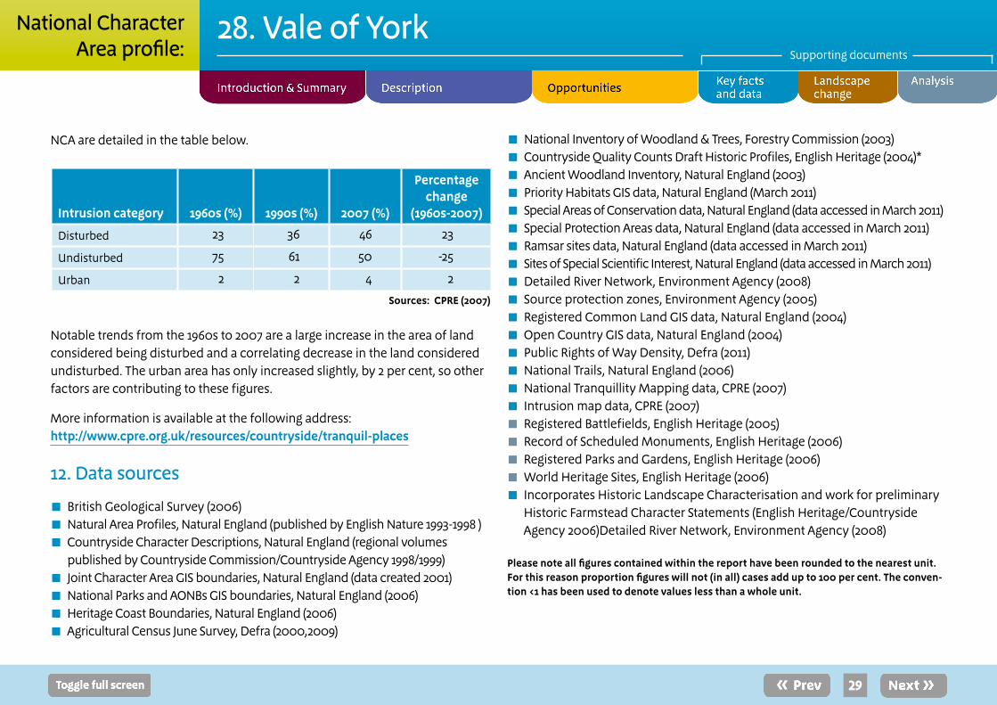
NCA are detailed in the table below.
Intrusion category 1960s (%) 1990s (%) 2007 (%)
Percentage change
(1960s-2007)
Disturbed 23 36 46 23
Undisturbed 75 61 50 -25
Urban 2 2 4 2
Sources: CPRE (2007)
Notable trends from the 1960s to 2007 are a large increase in the area of land considered being disturbed and a correlating decrease in the land considered undisturbed. The urban area has only increased slightly, by 2 per cent, so other factors are contributing to these figures.
More information is available at the following address:http://www.cpre.org.uk/resources/countryside/tranquil-places
12. Data sources
■ British Geological Survey (2006) ■ Natural Area Profiles, Natural England (published by English Nature 1993-1998 ) ■ Countryside Character Descriptions, Natural England (regional volumes published by Countryside Commission/Countryside Agency 1998/1999)
■ Joint Character Area GIS boundaries, Natural England (data created 2001) ■ National Parks and AONBs GIS boundaries, Natural England (2006) ■ Heritage Coast Boundaries, Natural England (2006) ■ Agricultural Census June Survey, Defra (2000,2009)
■ National Inventory of Woodland & Trees, Forestry Commission (2003) ■ Countryside Quality Counts Draft Historic Profiles, English Heritage (2004)* ■ Ancient Woodland Inventory, Natural England (2003) ■ Priority Habitats GIS data, Natural England (March 2011) ■ Special Areas of Conservation data, Natural England (data accessed in March 2011) ■ Special Protection Areas data, Natural England (data accessed in March 2011) ■ Ramsar sites data, Natural England (data accessed in March 2011) ■ Sites of Special Scientific Interest, Natural England (data accessed in March 2011) ■ Detailed River Network, Environment Agency (2008) ■ Source protection zones, Environment Agency (2005) ■ Registered Common Land GIS data, Natural England (2004) ■ Open Country GIS data, Natural England (2004) ■ Public Rights of Way Density, Defra (2011) ■ National Trails, Natural England (2006) ■ National Tranquillity Mapping data, CPRE (2007) ■ Intrusion map data, CPRE (2007) ■ Registered Battlefields, English Heritage (2005) ■ Record of Scheduled Monuments, English Heritage (2006) ■ Registered Parks and Gardens, English Heritage (2006) ■ World Heritage Sites, English Heritage (2006) ■ Incorporates Historic Landscape Characterisation and work for preliminary Historic Farmstead Character Statements (English Heritage/Countryside Agency 2006)Detailed River Network, Environment Agency (2008)
Please note all figures contained within the report have been rounded to the nearest unit. For this reason proportion figures will not (in all) cases add up to 100 per cent. The conven-tion <1 has been used to denote values less than a whole unit.
V1.0
29
28. Vale of YorkSupporting documents
National CharacterArea profile:

Recent changes and trends
Trees and woodlands ■ The NCA contains 4,924 ha of woodlands over 2 ha (5 per cent of the NCA) of which 825 ha is ancient woodland. Woodland distribution across the NCA is generally scattered but in some areas forms a key feature in the local landscape.
■ There has been scattered new planting to the west of York, and in the northern part of the NCA between Haxby and Dalton.
■ The area covered by Woodland Grant Scheme management agreements has been stable. The proportion of ancient woodland sites covered by an agreement has increased since 1999 from 31 per cent to 33 per cent.
Boundary features ■ The most frequent Countryside Stewardship agreements for linear features between 1999 and 2003 were hedge planting and restoration (71 km) and fencing (61 km), but extent was limited. The estimated boundary length for the NCA is about 8,156 km. At the end of March 2011 there was 1,351 km of hedgerows in Environmental Stewardship (ES). The other most common boundary options were 64 km of ditch in ES and 21 km of woodland.
Agriculture ■ The decline in grasslands seen before 1999 has not been reversed and grazing pressure has remained more constant than in other areas. Thus agricultural character remains relatively stable.
■ There is the perception that smaller farms are being amalgamated within larger farms as their tenures become available.
Settlement and development ■ This NCA shows a high rate of development outside the urban fringe, with development in the wider countryside and smaller settlements observed especially around York.
■ Pressure for development outside of the urban fringe and for food production are together putting a large pressure on the wetland system within the NCA both directly through loss of wetland habitats and in terms of increased water demand and increased water pollution through run off and discharges.
Semi-natural habitat ■ The uptake of annual Countryside Stewardship Agreements for area features was consistently below the national average. The most extensive annual Countryside Stewardship agreements in 2003 were for lowland pastures on neutral/acid soils (477 ha) and over-wintered stubble followed by a spring/summer fallow (416 ha).
Historic features ■ In 1918 about 2 per cent of the NCA was historic parkland. By 1995 it is estimated that 62 per cent of the 1918 area had been lost. About 30 per cent of the remaining parkland is covered by a Historic Parkland Grant, and 29 per cent is included in an agri-environmental scheme. About 65 per cent of historic farm buildings remain unconverted, and most are intact structurally.
30
Supporting document 2: Landscape change
28. Vale of YorkSupporting documents
National CharacterArea profile:
Coast and rivers ■ There is no evidence of Countryside Stewardship management agreements for riparian habitats. However, the biological river water quality in 1995 was predominantly excellent and it has been maintained. The chemical water quality in 1995 was predominantly very good and it has also been maintained.
■ Historically the natural flood plains of the major rivers have been drained to increase land for agricultural use and further losses of semi-natural habitat has occurred due to an intensification of cultivation techniques and a move away from traditional land management practices.
Minerals ■ There are two active sand and gravel quarries within the Vale of York, one west of Alne and the other at Newton upon Derwent. Any future opportunities for extraction8 will be for further sand and gravel extraction and they may provide opportunities for wetland habitat creation through site restoration.
Drivers of changeClimate change Climate change is likely to result in:
■ More frequent and extreme weather events resulting in increasing flood risk in river valleys of the Derwent, Swale, Nidd, Ure, Wharfe and Ouse, exacerbating existing flood problems within York.
■ Increased storm events during summer months are having a negative impact on the biodiversity of the traditionally managed flood plain
meadows. Bad weather during the traditional hay cutting period means that the quality of the habitats within many designated sites may be declining, in turn leading to a decrease in the species they support.
■ Summer droughts leading to increased water demands. This would also result in lower flow levels in the rivers and less water being available for domestic, business and agricultural usage. Under these conditions we are likely to see a reduction in water quality through increased pollution concentration.
■ Higher temperatures and prolonged periods of drought would put heathland vegetation under stress and increase the risk of wild fire events, which would impact on the diversity of structure and plant and animal species.
■ Warmer winters leading to increased tree growth of predominantly non-native species which may have positive and negative results.
■ A longer growing season potentially leading to double cropping.
■ Warmer climate leading to new crops.
■ Species migration and loss of small or isolated habitats.
■ There will be pressure for renewable energy generation including onshore wind turbines, and growth of biomass crops (Defra’s maps show mostly medium or high potential yield for Miscanthus and a medium potential yield short rotation coppice).9
8For information on future mineral extraction sites we direct you to the most up to date Local Planning Authority Mineral Spatial Planning Document9www.defra.gov.uk/food-farm/growing/crops/industrial/energy/opportunities/yh.htm
31
28. Vale of YorkSupporting documents
National CharacterArea profile:

Other key drivers ■ Continued development in and around York – York acts as a focus for economic development, housing supply, and a hub for transport links. The final boundary setting of the York green belt will contribute to the management of the growth of the city – new development projects will provide the opportunity to deliver new homes, increased business capacity and a mix of tourism through land remediation, archaeological protection, flood risk management, green infrastructure provision and transport improvements.
■ Development pressures within villages across the Vale risk mergence of separate villages, developments should seek to enhance the historic settlement pattern within the villages and avoid coalescing of settlements.
■ Increasing need for waste management facilities and landfill capacity (the region currently performs poorly in terms of recycling and recovery).10
■ Continued demand for sand and gravel (the Yorkshire and Humber Aggregate Mineral Resources map shows resources of sand and gravel in this area as well as some existing extraction sites).
■ Increased focus for tourism.
■ Increased pressure for food production.
■ The potential planting of flood plain woodland is also high. Larger areas ( more than 50 ha) are identified along key river corridors and watercourses such as the Ure, Nidd and Ouse, whilst smaller areas (more than 2 ha) are associated with smaller tributaries.11
■ Planning for improved flood storage and greater flood risk management will open up opportunities for increasing flood plains and flood storage areas and greater wetland habitat creation.
■ As a result of the commercial scale agricultural use of the NCA, much of the land is identified as being at a high or very high vulnerability to poaching and subsequent soil erosion.
10The Yorkshire and Humber Plan Regional Spatial Strategy to 2026, Government Office for Yorkshire and The Humber (May 2008)11Opportunity Mapping for Woodland to reduce Flooding in the Yorkshire and Humber Re-gion, Map 12, Forest Research (2009)
32
28. Vale of YorkSupporting documents
National CharacterArea profile:

Supporting document 3: Analysis supporting Statements of Environmental Opportunity
Cycling is encouraged even where the route meets a steep flight of steps.
33
The following analysis section focuses on a selection of the key provisioning, regulating and cultural ecosystem goods and services for this NCA. These are underpinned by supporting services such as photosynthesis, nutrient cycling, soil formation and evapo-transpiration. Supporting services perform an essential role in ensuring the availability of all ecosystem services.
Biodiversity and geodiversity are crucial in supporting the full range of ecosystem services provided by this landscape. Wildlife and geologically-rich landscapes are also of cultural value and are included in this section of the analysis. This analysis shows the projected impact of Statements of Environmental Opportunity on the value of nominated ecosystem services within this landscape.
28. Vale of YorkSupporting documents
National CharacterArea profile:

34
Statement of Environmental Opportunity
Ecosystem service
Food
pro
visi
on
Tim
ber p
rovi
sion
Wat
er a
vaila
bilit
y
Gen
etic
div
ersi
ty
Biom
ass
ener
gy
Clim
ate
regu
latio
n
Regu
latin
g w
ater
qu
ality
Regu
latin
g w
ater
fl
owRe
gula
ting
soil
qual
ityRe
gula
ting
soil
eros
ion
Polli
natio
n
Pest
regu
latio
n
Regu
latin
g co
asta
l er
osio
nSe
nse
of p
lace
/ in
spira
tion
Sens
e of
his
tory
Tran
quill
ity
Recr
eatio
n
Biod
iver
sity
Geo
dive
rsity
SEO 1: Identify opportunities within the existing agricultural systems to enhance landscape character and create a functioning ecological network to safeguard fu-ture food provision, retain soil quality and reduce soil erosion and deliver benefits for biodiversity, carbon storage and climate regulation.
**
*
*
n/a
*
**
**
**
**
**
**
*
n/a
**
*
*
*
*
*
SEO 2: Manage and enhance the network of rivers and important wetland habitats within the Vale, increasing the landscape’s ability to naturally and sustainably manage flood and drought risk and provide other ecosystem services while recognising the needs of indi-vidual species and habitats and increasing the resilience of wildlife to climate change.
*
**
**
n/a
**
***
***
***
**
**
*
*
n/a
**
*
**
*
***
**
SEO 3: Increase the network of species-rich meadows, pastures, fields and hedge-rows, ensuring that they and the wider farmed environment are managed to reduce rates of diffuse pollution and improve water quality. Extend and enhance heath-land sites on areas of sandy soil for the benefit of biodiversity, as well as enhancing the sense of place.
°
**
*
n/a
*
**
**
**
**
**
**
*
n/a
*
*
**
*
***
*
SEO 4: Protect the historic and cultural features of the Vale, in particular the traditional settlement patterns of remaining villages and the evidence of previous settlements that provide a strong sense of place.
**
*
*
n/a
*
*
*
*
*
*
*
*
n/a
**
***
**
*
*
*
Note: Arrows shown in the table above indicate anticipated effect on service delivery = Increase = Slight Increase = No change = Slight Decrease = Decrease. Asterisks denote confidence in projection (*low **medium ***high) = symbol denotes where insufficient information on the likely effect is available .
Dark plum = national importance; mid plum = regional importance; light plum = local importance
28. Vale of YorkSupporting documents
National CharacterArea profile:

35
28. Vale of YorkSupporting documents
Landscape attributes
Landscape attribute Justification for selection
Open and low lying landscape, mainly agricultural land use dominated by arable fields.
■ The NCA sits in contrast to the higher surrounding land, the open nature allows long views across the landscape.
■ An important area for agriculture, the predominance of this land use along with the hedgerow boundaries has helped maintain the more rural setting of this NCA.
■ The area has a long history of agriculture from cropmark evidence of previous settlements to scattered large brick farmsteads indicative of the agricultural prosperity of the 19th century.
■ Increased diversification or changes in crops or land use will influence feel of landscape and the historic layout of the countryside.
■ Underlying geology is hidden so subtle variation in land use is governed by the soil type and quality.
■ Small ponds, ditches and hedgerows within the farmed environment provide extra features breaking up the landscape.
National CharacterArea profile:

36
28. Vale of YorkSupporting documents
Landscape attribute Justification for selection
Rivers and their flood plains. ■ Rivers provide important backdrops for local landscape, with water a key theme throughout the area, and rivers are important features providing character to the NCA.
■ There are a large number of rivers that drain through the NCA providing important north-south corridors for species migration.
■ There is a great variety in the speed and size of the watercourses which mean the NCA as a whole supports a wide range of water dependent flora and fauna. This can particularly be seen in the Lower Derwent Valley, internationally designated wetlands; that supports large populations of breeding waders on the flood plain grazing marsh and neighbouring habitats.
■ The high level of water passing through the NCA supports extractions for agriculture and other uses.
■ Pressure on the land for agriculture means that flood plain habitats have become fragmented as more land has been used for crops or grazing. Restoring the network of habitats across the flood plain would benefit biodiversity and landscape and reduce flooding further downstream.
Heathland sites on poorer sandy soils along with scattered conifer plantations.
■ Areas of heathland would have once been much more extensive within the landscape. This habitat, reliant upon human intervention, has been reduced in the NCA to two main areas which are designated as internationally important areas for the habitat and birds they support.
■ The heathland habitat supports important entomological and ornithological communities, including breeding populations of European nightjars.
■ Historically sandy soils are also where conifer plantations have been focused, these areas provide opportunities to revert back to heathland especially as this wood comes to maturity.
National CharacterArea profile:

37
28. Vale of YorkSupporting documents
Landscape attribute Justification for selection
Historic central City of York ■ The City of York sits at the centre of the NCA with roads radiating out from it as spokes on a wheel. There has been a history of settlement here, which brings in a high number of tourists to the area.
■ York Minster forms a prominent landmark and focal point for the Vale and visitors to the area.
■ There is development pressure around the city that could lead to development sprawl that takes away from the enclosed dominance of the town centre.
Historic features and evidence of past settlements scattered through the landscape.
■ Extensive cropmark evidence of bronze-age to Romano-British settlement provides insight into a previous way of life.
■ There are a number of opportunities to study old field systems and farmsteads.
■ The Vale of York is one of two main concentrations of medieval 18th-century bridges in England. These bridges provide evidence of the advance engineering of the time and the rapid desire to expand the road network. They can also be important for supporting roosting bats.
Distinctive settlement pattern of linear villages. ■ Villages in the Vale are generally linear in nature and are centred on a main road. The road will be flagged by wide grass verges and at the heart of the community will be village greens, ponds and churches. The rural scene is added to by small streams and individual mature trees.
■ Villages are linked to large tracts of agricultural land surrounding nucleated and planned villages. The area includes a number of isolated farmsteads and former medieval grange farms.
National CharacterArea profile:

Flooding, as seen here where the River Derwent has overtopped the floodbank, is a concern within the Vale and regulation of water flow a key ecosystem service that can be provided through natural management of the rivers and floodplains.
38
28. Vale of YorkSupporting documents
Landscape opportunities
■ Conserve and protect the historic setting of the City of York and the traditional settlement patterns seen throughout the NCA that give the area a rural and open feeling. Plan to encourage development that is in-keeping with the current pattern of satellite villages in the wider countryside around York. Maintain a radial infrastructure network of roads and avoid ‘filling in’ developments or structures.
■ Plan to conserve the settlement character by using traditional building materials in new developments.
■ Restore and re-establish the network of hedgerows, which is not of high quality throughout the NCA and is replaced by fences in some places, to improve habitat connectivity through agricultural areas. Plan to increase native hedgerow trees in existing hedges and restore mixed native hedges to areas where they have been lost to enhance the traditional pattern and management of the landscape.
■ Protect, manage and expand areas of lowland heathland. Encourage appropriate habitat mosaics at heathland sites to support a wide variety of species including populations of internationally important species such as the European nightjar. Where appropriate reduce, or thin, conifer plantations to increase heathland understorey and habitat to areas of poor quality and sandy soils.
■ Maintain, enhance and expand the mosaic of habitats across the river flood plains. In particular areas in the Lower Derwent Valley and along rivers south of York there are opportunities to repair fragmented flood plain habitats. Plan to adapt agriculture in these areas to focus away from the river edge and to adopt complementary practices for wildlife, in particular land management practices such as haymaking. Plan to reduce impacts of agriculture and development on the riverine systems and increase flood plain grazing marsh.
■ Protect and enhance a mosaic of habitats and features. Small patches of semi-natural habitat, ponds and ditches on farms and in villages provide important
stepping stones through the farmed landscape for species to use, adding diversity to the landscape and extra features of interest.
■ Manage and enhance areas of native woodland within the Vale. Currently woodland is mainly restricted to small copses and individual trees within the agricultural areas with a few larger, generally non-native, plantations on poorer soils.
■ Maintain quality and knowledge of archaeological evidence and historic built features across the NCA. Plan for land management practices to be sympathetic to potential evidence in the area and enhance public awareness of the breadth of historic wealth of the Vale.
■ Plan to increase recreation and access across the NCA as there is currently little access for people to land outside of towns and villages and link to the long distance trails of the Yorkshire Wolds Way and the Ebor Way.
National CharacterArea profile:

Service
Assets/attributes: main contributors to service State
Main beneficiary Analysis Opportunities
Principal services offered by opportunities
Food provision
Cereal and root crops
Livestock grazing
54 per cent Grade 3 soils.
28 per cent Grade 2 soils.
Predominantly arable farming with some livestock rearing and dairy farming.
Regional The soil quality and water availability have supported high levels of agriculture in the NCA.
Intensification of agriculture has led to the loss of semi-natural habitats, especially through drainage of flood plains which, in places has negative impacts on the viability of the natural elements that underpin food provision services. Flood events in summer lead to a loss of crops, which may be alleviated by the creation of semi-natural habitats within key locations within the flood plain to provide long term crop security.
Many historic features are within the farmed environment, both obvious above ground and hidden features. Cultivation can damage archaeological features in agricultural fields; these features need to be taken into consideration in farm management plans.
Seek opportunities to expand food production sustainably; ensuring that by doing so it does not negatively impact on other ecosystem services. Encourage the use of sympathetic farming practices as described for other ecosystem services.
Sustainable food production should be developed to maintain the historic features in the environment such as shallow cultivation.
Opportunities to adapt to alternative crops or change the use of land to alleviate losses of current agricultural production in response to climatic changes and changes in flood risk.
Biodiversity
Sense of place/inspiration
Food provision
39
28. Vale of YorkSupporting documents
(Footnotes)
5 Natural England website, Opportunities and optimum sitings for energy crops, http://www.naturalengland.org.uk/ourwork/farming/funding/ecs/sit-ings/areas/041.aspx
6 Environment Agency, Humber River Basin Management Plan, December 2009.
7 Environment Agency, River Basin Management Plan, Humber River Basin District, Annex A: Current state of waters, December 2009.
8 Natural England, Capital Grant Scheme - Funding Priority Statement 2010/11, Catchment 6: East Riding of Yorkshire and North Lincolnshire, date unknown.
9 Environment Agency, The Humber Flood Risk Management Strategy, March 2008
10 Environment Agency, The Humber Flood Risk Management Strategy, March 2008
11 Humber Estuary Coastal Authorities Group, Flamborough Head to Gibraltar Point Shoreline Management Plan Non-Technical Summary, Con-sultation Draft, 2009
12 Environment Agency, Hull and Coastal Streams Catchment Flood Management Plan, draft main stage summary document, June 2008
13 Environment Agency, Grimsby and Ancholme Catchment Flood Management Plan: Summary report, December 2009
14 CPRE intrusion map, 2007
Ecosystem service analysis The following section shows the analysis used to determine key Ecosystem Service opportunities within the area. These opportunities have been combined with the analysis of landscape opportunities to create Statements of Environmental Opportunity.
Please note that the following analysis is based upon available data and current understanding of ecosystem services. It does not represent a comprehensive local assessment. Quality and quantity of data for each service is variable locally and many of the services listed are not yet fully researched or understood. Therefore analysis and opportunities may change upon publication of further evidence and better understanding of the inter-relationship between services at a local level
National CharacterArea profile:

Service
Assets/attributes: main contributors to service State
Main beneficiary Analysis Opportunities
Principal services offered by opportunities
Timber provision
Conifer plantations
Broadleaved woodland
Current woodland levels in the NCA are some of the lowest in the UK and timber provision is mainly from plantations on historic heathland sites.
Total cover is 5 per cent of the NCA and woodland is generally limited to small scattered broadleaved woodlands, although there are more extensive conifer plantations and remnant ancient woodlands on sandy soils in the south and east of the NCA.
Local Further woodland planting in the NCA could increase opportunities for timber provision and there is potential to increase timber provision through bringing unmanaged woodland back under management.
Planting would need to be sensitively located to increase biodiversity and retain rare species of flora and fauna. Planting should be avoided on heathland and wetland sites (except where wet woodland is appropriate) and could be targeted to copses and shelter belts around farmsteads.
Increase native woodland planting to provide increases in timber and biodiversity, enhance landscape and improve the ecological network.
Expansion should also be considered to mitigate flood risk. Planting within the flood plain has been identified as a priority over the NCA with planting in the wider catchment, which could also bring benefits for flood mitigation, especially in the south of the NCA.12
Encourage better management of ancient woodlands and creation of new woodlands, prioritising planting to increase, buffer and link existing patches of habitat.
Climate regulation
Water regulation
Biodiversity
Water availability
Regulating water quality
Sense of place/inspiration
Biomass energy
Timber provision
12Opportunity mapping for woodland to reduce flooding in the Yorkshire and the Humber region, Forest Research Monograph, 1, S Broadmeadow and T Nisbet (2010), Forest Research, Surrey
40
28. Vale of YorkSupporting documents
National CharacterArea profile:

Service
Assets/attributes: main contributors to service State
Main beneficiary Analysis Opportunities
Principal services offered by opportunities
Biomass energy
Woodlands (4,924 ha)
Miscanthus
Short rotation coppice
Currently limited, woodland cover is low and new large plantations unlikely. There has been an increase in biomass crops being grown around York since the closure of the sugar beet factory.
Local There is a medium potential yield for miscanthus to the north-west of York and a high potential yield around and to the east of York. In the case of short rotation coppice, there is generally medium potential yield for short rotation coppice throughout the NCA. Impacts of this planting on landscape features can be found on the Natural England website.13
In high potential yield areas planting of miscanthus can be targeted where it may help alleviate flood risk whilst avoiding impacts on the provision of other services.
Improve management of woodlands to make them more productive for yielding biomass.
Biomass energy
Climate regulation
Regulating water flow
Sense of place/inspiration
Biodiversity
Regulating soil erosion
13Opportunities and optimum sitings for energy crops, Natural England (accessed December 2010; URL:www.naturalengland.org.uk/ourwork/farming/funding/ecs/sitings/areas/028.aspx)
41
28. Vale of YorkSupporting documents
National CharacterArea profile:

Service
Assets/attributes: main contributors to service State
Main beneficiary Analysis Opportunities
Principal services offered by opportunities
Water availability
Rivers
Aquifer
Canal
The western half of the NCA overlays the Sherwood sandstone aquifer, a major source of drinking water for the region.14 There is generally ‘water available’ for abstraction from this aquifer within this NCA;15 Environment Agency records suggest that in the south and south-west of York, the aquifer is ‘over licensed’.16 17
There is high water demand from the rivers in the NCA and the River Ouse and its major tributaries, the Ure, Swale, Nidd and Foss, and the Pocklington Canal all have a resource availability status of ‘no water available’ for additional abstraction.18 19
Resource availability has not been assessed for the River Wharfe.20
The River Derwent is ‘over licensed’ within the NCA as it runs through21 the eastern section.
Regional The River Derwent is a major public water supply for Yorkshire & Humber, providing a significant potable water resource to a number of large towns and cities stretching down to south Yorkshire. The rivers of the NCA provide water for agricultural irrigation as well as public drinking water. High levels of unsustainable abstraction create low flow levels that negatively impact on biodiversity and water quality in terms of Water Framework Directive assessment.
Rainfall within the NCA is relatively low - current land uses persist because of abstraction and water management.
Increases in semi-natural habitats within new developments and the wider countryside such as increased areas of grassland and woodland will improve water infiltration increasing ground water stocks.
Opportunities to increase storage of water on farms and sympathetic land management practices in agricultural areas would better enable farms to deal with increased temperatures and drought conditions, reducing abstraction capability from surface and groundwater sources.
Opportunities to improve sustainable use of water and sympathetic land management practices.
Increase areas of semi-natural habitats to increase infiltration such as grassland strips along water courses and creation of flood plain grazing marsh.
Biodiversity
Regulating water flow
Regulating water quality
Climate regulation
Food provision
Water availability
14 Humber River Basin Management Plan, main document, Environment Agency (December 2009)15 Swale, Ure, Nidd and Upper Ouse Catchment Abstraction Management Strategy, Environment Agency (March 2004)16 Aire and Calder Catchment Abstraction Management Strategy, Environment Agency (May 2007)17 Humber River Basin Management Plan, main document, Environment Agency (December 2009)18 Swale, Ure, Nidd and Upper Ouse Catchment Abstraction Management Strategy, Environment Agency (March 2004)19 Derwent Catchment Abstraction Management Strategy, Environment Agency (March 2006)20 Wharfe and Lower Ouse Catchment Abstraction Management Strategy, Environment Agency (March 2005)21 Derwent Catchment Abstraction Management Strategy, Environment Agency (March 2006)
42
28. Vale of YorkSupporting documents
National CharacterArea profile:

Service Assets/attributes: main contributors to service
State Main beneficiary
Analysis Opportunities Principal services offered by opportunities
Climate regulation
Soil
Woodland
Wetlands
Species-rich grassland
There is generally a low soil carbon content of 5 per cent throughout the NCA. Two small pockets of very high carbon content soils of 20-50 per cent are found around York and associated with sandy soils of the lowland heath at Strensall Common.22 Higher soil carbon content will be found under the remaining 4,000 ha of semi-natural habitats such as grazing marsh, wetlands and grasslands and the 3,691 ha of woodland.
International There is currently high pressure on the grazing marsh, wetland and areas of semi-natural grassland from drainage of land for increased agriculture and development. In agricultural areas carbon sequestration and storage can be increased by management that reduces the frequency of cultivation and adds organic matter.
Soils in the Vale currently provide low carbon storage partly due to cultivation and drainage. Reducing drainage and establishing permanent vegetation on soils, especially those derived from lake clays, would increase their capacity to store carbon.
Increased woodland planting, combined with better management of woodland sites would increase carbon sequestration and storage.
Semi-natural habitats can directly help regulate climate through providing cooling effects and reduction in run-off in developed areas and, indirectly through increased sequestration and storage of carbon.
Seek opportunities to restore and expand woodland and semi-natural habitats and bring them under sympathetic management to increase carbon storage.
Reduce frequency of cultivation and seek opportunities to add organic matter to the soils for example through use of green manure crops within rotations and increase uncultivated field margins. Reduce drainage intensity to increase carbon storage.
Protect and expand areas of flood plain grazing marsh and wetland and grassland habitats.
Climate regulation
Biodiversity
Regulating water flow
Regulating water quality
Biomass energy
Regulating soil erosion
Regulating soil quality
Water availability
22 NSRI National Soils Map for England and Wales, Environment Agency (January 2009)
43
28. Vale of YorkSupporting documents
National CharacterArea profile:

Service Assets/attributes: main contributors to service
State Main beneficiary
Analysis Opportunities Principal services offered by opportunities
Regulating soil erosion
Acid, sandy, loamy, clayey soils
Semi-natural vegetation cover
Almost the entire NCA lies within one of Defra’s ‘Yorkshire Derwent’ or ‘Yorkshire Ouse, Nidd and Swale’ priority catchments with the light sandy soils across much of the Vale highlighted because they are prone to soil erosion.
48 per cent of the soils in this NCA are not susceptible to soil erosion. Those that are include the naturally wet very acid sandy and loamy soils (26 per cent of NCA) that are easily eroded if heavily trafficked or after heavy rain. Soils are also prone to wind erosion. The slightly acid loamy and clayey soils with impeded drainage (11 per cent of NCA) that is prone to compaction and capping / slaking, increasing the risk of erosion from surface water run-off, especially on steeper slopes.
The freely draining sandy and loamy soils (together covering 14 per cent of the NCA) are at enhanced risk of erosion on steeper slopes where bare or cultivated soil is exposed. This is exacerbated where organic levels are low after continuous cultivation or where soils are compacted. There may also be a risk of soil erosion where soils are left bare, especially in spring and in areas where root crops are grown intensively.
Regional The high level of agricultural land use means that soil erosion is an important issue in this NCA, reducing soil erosion will retain the service and protect the local ability to farm the land profitably for the long term.
Managing the land to reduce soil erosion may, in the short term, be a constraint to increasing food provision levels but will, in the long term help maintain the productivity of the land. The better management of soils and reduction in soil compaction will see improvements for water quality and flow in the NCA rivers and likely a corresponding improvement in biodiversity.
Changes in land management (as encouraged by catchment sensitive farming such as the use of cover crops), especially on areas of light, sandy soils would provide opportunities to improve soil structure and drainage and reduce rates of soil loss.
Decrease the frequency and intensity of cultivation, increase in field margins and grassland habitats, use of green manure crops and winter stubble. Management of stocking regimes could reduce compaction in areas where grazing is currently high to reduce poaching and compaction, with timing and good stock husbandry as key actions.
Regulating soil erosion
Regulating soil quality
Food provision
44
28. Vale of YorkSupporting documents
National CharacterArea profile:

Service Assets/attributes: main contributors to service
State Main beneficiary
Analysis Opportunities Principal services offered by opportunities
Regulating soil quality
Low, flat topography
Glacial and lacustrine clay, lacustrine and blown sands
Alluvium along river valleys
Boulder clay
There are 8 main soilscape types in this NCA:
◼Slowly permeable seasonally wet slightly acid but base-rich loamy and clayey soils, covering 37 per cent of the NCA. ◼Naturally wet very acid sandy and loamy soils (26 per cent). ◼Slightly acid loamy and clayey soils with impeded drainage (11 per cent); ◼Freely draining slightly acid sandy soils (7 per cent). ◼Loamy soils with naturally high groundwater (6 per cent). ◼Loamy and clayey flood plain soils with naturally high groundwater (5 per cent). ◼Freely draining slightly acid loamy soils (4 per cent). ◼Freely draining lime-rich loamy soils (3 per cent). Compaction is a characteristic shared by the main soil types in this NCA.
Regional The high agricultural grade soils in the NCA are important for food production. The slowly permeable seasonally wet slightly acid but base-rich loamy and clayey soils (37 per cent of the NCA) may suffer compaction and/ or capping as they are easily damaged when wet. In turn this may lead to increasingly poor water infiltration and diffuse pollution as a result of surface water run-off. In areas with slightly acid loamy and clayey soils with impeded drainage (11 per cent) the soils are easily poached by livestock and compacted by machinery when the soil is wet and the weak topsoil structures can easily be damaged.
Changing management practices to reduce damage to soil quality could provide increases in food production in the long term. Increases in soil quality will reduce negative impacts from farming on the natural environment through reduction in run-off pollution; this will improve water quality and biodiversity.
Where sections of the waterbodies are canalised, silts are not deposited in the flood plain reducing one of the natural processes to maintain soil quality.
Seek opportunities to increase management measures that increase organic matter levels.
Seek opportunities to reduce compaction through management of land.
Time agricultural activities and livestock movements to avoid when the soil is very wet to maintain soil quality for future food production.
Regulating soil quality
Regulating water quality
Climate regulation
Regulating soil erosion
45
28. Vale of YorkSupporting documents
National CharacterArea profile:

Service Assets/attributes: main contributors to service
State Main beneficiary
Analysis Opportunities Principal services offered by opportunities
Regulating water quality
Rivers
Aquifers
Agriculture
The ecological potential or status of waterbodies in the NCA is generally ‘moderate’ with some short river lengths of ‘good’ or ‘poor’ status.23
In terms of surface water chemical status, the River Ouse is ‘failing to achieve good’ chemical status. Along the River Ouse, water quality improvements have been made in the past decade with the biological water quality of the Ouse classified as excellent to good in 2000.24
The chemical status of groundwater aquifers is ‘good’ in the west and ‘poor’ in the east of the NCA23 with the groundwater status in the Vale of York (in the Yorkshire Ouse, Nidd and Swale’ priority catchment) identified as suffering from groundwater failures in 2001-2005 at Rainton and Ainderby Steeple with a high priority for pesticide action.
Regional High levels of pesticides, nutrients (nitrates and phosphate) and sediment loads within the watercourses of the east of the NCA are a result of diffuse agricultural pollution associated with intensive arable production and a large area under root crops, which also contributes to increased soil erosion. In the west of the NCA high phosphate and pesticide levels are associated with the dominance of arable farming and the high proportion of pig and poultry farms.
The River Foss flows are dominated by wastewater treatment work discharges and land drainage, and there has been evidence of reduced water quality and nutrient enrichment.24
There are opportunities on agricultural land to reduce water run-off through changes in management practices (as advocated by catchment sensitive farming.
Seek to increase grassland strips along field drains and watercourses to capture sediment and nutrients.
Create buffer areas between nutrient input and sensitive riparian habitats, areas high in biodiversity and watercourses.
Ensure the use of fertiliser and pesticide is more informed and associated with good infield analysis to ensure input is exacting to reduce the volumes which are applied. Improve infield soil management and protection to support sustainable crop production and reduce exacerbated soil erosion risks.
Seek opportunities to diversify or adapt field management in areas of high risk crops, such as root crops, on vulnerable slope areas, areas adjacent to watercourses, prone soil types will reduce soil erosion and improve water quality regulation.
Encourage crops with a lower demand for fertilisers to reduce diffuse pollution of water courses/aquifers from, for example nitrates and phosphates.
Regulating water quality
Regulating soil erosion
Biodiversity
Regulating soil quality
Food provision
Climate regulation
23 Humber River Basin Management Plan, Annex A: Current state of waters, Environment Agency (December 2009) 24 Swale, Ure, Nidd and Upper Ouse Catchment Abstraction Management Strategy, Environment Agency (March 2004)
46
28. Vale of YorkSupporting documents
National CharacterArea profile:

Service Assets/attributes: main contributors to service
State Main beneficiary
Analysis Opportunities Principal services offered by opportunities
Regulating water flow
Rivers
Wetland habitats
Woodland
Urban surfacing
Primary fluvial flood risk in this NCA is associated with the River Ouse catchment, which has a long history of flooding; particularly notable floods occurred in 1947 and 1982, and in 2000 when over 550 properties flooded between Linton-on-Ouse (north west of York) and Selby (south of this NCA).25
In and around York there are a large number of properties – approximately 4,200 – at risk of flooding from the River Ouse following prolonged rain in the upper catchment, with a slow build-up in the flood risk. However, smaller urban watercourses through York are susceptible to more rapid flooding. Existing flood defences currently protect the City, but various washlands upstream of the City play a crucial role in managing the risk in York. Other communities at risk include Bishopthorpe and Haxby (both near York) which each have up to 2,000 properties at risk, and Strensall which has up to 1,000 properties at risk. The village of Lower Dunsforth in the north of the NCA can be completely cut off by flooding of the Ouse.25
Regional Environment Agency Catchment Flood Management Plan options (July 2010) identify opportunities for increasing flood storage along the Ouse reaches up and downstream of York in the NCA and outside the NCA. The main options identify opportunities to reduce flood risk through sustainable land management, changing land drainage practices, increasing surface roughness to reduce the likelihood of flooding around York and in the south of the NCA.
Re-naturalisation of the flood plain can dissipate energy from the water flow and increase the ability of areas to retain floodwaters upstream of flood risk areas. Changes to water regime could lead to changes in land viability for food production, or adaptive management techniques could ensure food production continues alongside a more natural flood regime.
Land management measures upstream in the river catchments may have beneficial effects to reduce flood risk downstream in the Vale of York. Additional planting of woodland on higher ground surrounding the NCA, linked with other habitat creation opportunities, may help mitigate flooding downstream within the Vale of York but will need to be sympathetic to existing habitats and species that could be directly and indirectly affected by the measure.
Continued over...
Seek opportunities to restore a more naturally functioning flood plain and river morphology.
Create and expand wetland habitats to increase water storage within the flood plains and slow down the movement of water in the system, holding back water in peak flow events to reduce flood risk further downstream.
There are opportunities to improve hedgerow density and tree belts to reduce cross land flows of flood water and retain high volumes of flood water in flood plains.
Promote sustainable drainage in developments to increase use of semi-natural habitats and permeable surfacing to reduce run-off and increase water filtration; slowing water entering the system.
Seek appropriate opportunities for flood storage in locations where people and property are not at risk. This may present opportunities for changes in land use and management that can benefit ecosystems and biodiversity.
Regulating water flow
Biodiversity
Regulating water quality
Regulating soil erosion
Regulating soil quality
Climate regulation
Food provision
25 Draft Ouse Catchment Flood Management Plan, Summary Report, Environment Agency (January 2010)
47
28. Vale of YorkSupporting documents
National CharacterArea profile:

Service Assets/attributes: main contributors to service
State Main beneficiary
Analysis Opportunities Principal services offered by opportunities
Regulating water flowContinued
Continued from previous...
In the Ouse catchment the Environment Agency is looking to maximise the potential of flood storage, reduce run-off and tributary re-phasing which it thinks will result in a reduction in flow at York. The role of sustainable land management practices may also result in a reduction in localised flooding. Actions to be considered include changing land drainage practices; reducing practices that keep soil bare in wet periods; buffer and/or fallow strips; restoring grassland and improved hedge management.
Pollination Semi-natural habitat, hedgerows, field margins, road verges
Existing heathland, meadows, and grassland totalling just over 1,000ha (1 per cent of the NCA area) provide limited nectar sources for pollinating insects in this NCA. This means the network coverage and distribution is poor. Nectar sources will be provided by the gardens of the City of York.
Regional Poor networks of pollinator habitat limit the ability for pollinators to supply this service. Increases in habitat for pollinators such as creation of areas of semi-natural habitat, hedgerow improvement and increases in field margins will increase the delivery of this service. These measures would create important corridors and habitat mosaics for pollinator species. A strong pollinator population supports production of a wider variety of food products and supports food production in the future.
Seek opportunities to increase nectar provision within the agricultural landscape through promotion of diverse field margins and creation of more semi-natural habitats.
Create networks of habitat through changes in management and improvements to hedgerows, road verges and field margins. Networks will support greater diversity of food production into the future.
Pollination
Biodiversity
Regulating water quality
Food provision
Climate regulation
Regulating soil erosion
48
28. Vale of YorkSupporting documents
National CharacterArea profile:

Service Assets/attributes: main contributors to service
State Main beneficiary
Analysis Opportunities Principal services offered by opportunities
Pest regulation
Existing semi-natural habitats
Field margins and hedgerows
Although there are areas of semi-natural habitat within the NCA these are often fragmented. The existing field boundary hedgerows are commonly sparse and not diverse in species.
Local Increasing diversity in species and structure of field margins will increase the ability for these areas to support populations of pest regulating species such as invertebrates, birds and mammals.
There are opportunities to improve the network of semi-natural habitats across the NCA through appropriate management of existing habitats and creation of new areas of habitat.
Take opportunities to increase and manage appropriately semi-natural habitats. Seek opportunities to increase diversity of structure and composition within areas of semi-natural habitat to support a variety of pest regulating species.
Seek opportunities to increase field margins, species rich hedgerows and beetle banks to encourage a network of habitats for pest regulating species close to areas of agricultural production.
Pest regulation
Pollination
Biodiversity
Food provision
49
28. Vale of YorkSupporting documents
National CharacterArea profile:

Service Assets/attributes: main contributors to service
State Main beneficiary
Analysis Opportunities Principal services offered by opportunities
Sense of place/ inspiration
Fertile soils, rivers and flood plains
Village settlements
Topography
City of York
A sense of place is provided by the predominantly agricultural nature of this low-lying undulating landscape which is crossed by a number of low sandy ridges formed by glacial moraines or eskers and intervening flood plains of a number of rivers.
Scattered shelterbelts and medium to large, predominantly arable fields enclosed by intermittent, low, flailed hedges with few hedgerow trees are typical and on higher ground more extensive conifer plantations on sandy soils, together with small woodlands create an impression of wooded farmland.
Remnant heathlands and commons further underline the sandy nature of the ridges while reed beds and flood plain grazing marsh reinforces the character of the flood plains. The main settlement of the area, the City of York, dominates the area with its minster forming a distinctive landmark visible from long distances and with the main routes of the NCA radiating from its centre.
Regional The NCA sense of place is provided by the large agricultural areas and the interplay between these and the numerous rivers and water courses that cross the valley. Increasing access to these features will increase understanding and appreciation of their importance.
There are opportunities to increase sense of place by protecting the open and rural feel of the NCA through retention of the field patterns and improved management and restoration of the hedgerow network. New woodland planting should be focused in small copses and shelterbelts around farmsteads and other naturally occurring woodlands.
New developments and redevelopments should be sympathetic to the historic settlement patterns and materials used to maintain the ‘quaint’ village feel.
Natural flood plain management and creation of wetland habitats will strengthen the impact of the waterways on the NCA sense of place.
Preserve views to and from York and the principal landmarks by managing development so they do not tower over these landmarks and avoid locations that inhibit key views.
Sense of place/ inspiration
Recreation
Sense of history
Tranquillity
Biodiversity
50
28. Vale of YorkSupporting documents
National CharacterArea profile:

Service Assets/attributes: main contributors to service
State Main beneficiary
Analysis Opportunities Principal services offered by opportunities
Sense ofhistory
Field patterns
Local building materials, settlement and styles
City of York, York Minster, city walls
Historic events such as Battle of Stamford Bridge
A sense of history is evident in the remains of Roman settlements and associated Roman roads, forts and signal stations and the distinctive Roman fortress of York itself. Across the landscape there is a strong pattern of medieval nucleated settlement and distinctive linear villages (like those in the Vale of Mowbray).
Large brick built farmsteads are also a common feature in the landscape. There is a strong vernacular of mottled brick with pantile roofs. The history of farming can be traced through the field patterns with large regular shaped fields (dating back to Parliamentary enclosure and before) and the wheel houses traditionally used for horse-powered threshing machinery while there are some remnants of woodland from the historic Galtres Forest north of York.
Aspects of history that are likely to be most evident to the general public focus on the historic City of York with its distinctive Roman walls, York Minster, the fine collection of pre-17th-century traditional timber-frame buildings, and the City’s masonry bridges (one of two main concentrations of medieval and18th-century bridges in England) and surrounding historic buildings and parklands including (Bilton Hall, Rufforth Hall, and Beningbrough Hall).
National The varied historic features within the NCA are an important part of its character. The NCA has a high number of both upstanding and buried heritage.
Loss of traditional village patterns and building materials from increased development pressure has been seen to some extent across the NCA to date especially as new developments tend to lack the traditional features such as village ponds and greens the communities are built around. Continued expansion of larger villages and the City of York detract from the rural feel of the NCA.
Parklands and the associated country homes give a sense of the wealth that the agricultural value of the area brought. These remain important historical assets.
Protecting the remains and artefacts found across the NCA through reducing damage from cultivation. Shallow tilling will protect cropmarks and ground features.
Protecting the historic settlement pattern within rural villages and across the NCA as a whole through new developments.
Maintenance of the large house estates along with their associated parkland will increase sense of history and their link to historical features in the landscape.
Use local materials in buildings to maintain distinctive historical style of the area.
Sense of history
Recreation
Sense of place/inspiration
Tranquillity
51
28. Vale of YorkSupporting documents
National CharacterArea profile:
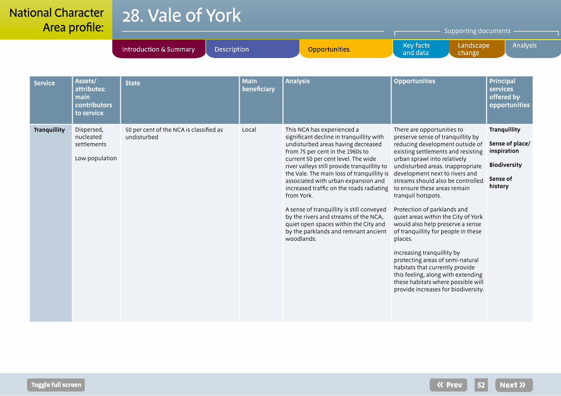
Service Assets/attributes: main contributors to service
State Main beneficiary
Analysis Opportunities Principal services offered by opportunities
Tranquillity Dispersed, nucleated settlements
Low population
50 per cent of the NCA is classified as undisturbed
Local This NCA has experienced a significant decline in tranquillity with undisturbed areas having decreased from 75 per cent in the 1960s to current 50 per cent level. The wide river valleys still provide tranquillity to the Vale. The main loss of tranquillity is associated with urban expansion and increased traffic on the roads radiating from York.
A sense of tranquillity is still conveyed by the rivers and streams of the NCA, quiet open spaces within the City and by the parklands and remnant ancient woodlands.
There are opportunities to preserve sense of tranquillity by reducing development outside of existing settlements and resisting urban sprawl into relatively undisturbed areas. Inappropriate development next to rivers and streams should also be controlled to ensure these areas remain tranquil hotspots.
Protection of parklands and quiet areas within the City of York would also help preserve a sense of tranquillity for people in these places.
Increasing tranquillity by protecting areas of semi-natural habitats that currently provide this feeling, along with extending these habitats where possible will provide increases for biodiversity.
Tranquillity
Sense of place/inspiration
Biodiversity
Sense of history
52
28. Vale of YorkSupporting documents
National CharacterArea profile:

Service Assets/attributes: main contributors to service
State Main beneficiary
Analysis Opportunities Principal services offered by opportunities
Recreation Public rights of way network
National Trails
Local Nature Reserves
The NCA offers a network of rights of way totalling 816 km at a density of just under 0.8 km per km2 as well as a small amount of open access land covering 290 ha or just 0.28 per cent of the NCA. In addition, the Ebor Way long distance route runs north-east to south-west passing through York and a very short section of the Yorkshire Wolds Way National Trail passes through the south-east corner of the area. The historic wealth of the City of York ensures it is a popular tourist destination.
Regional Large numbers of tourists visit York for its natural and historic features with recreation opportunities around these features high. Where these could be extended regarding natural features care will need to be taken to ensure that increased recreational pressure does not have negative impacts on the flora and fauna for example impacts of increased recreation on heathland sites.
In comparison to this access for people living in the Vale is much lower than the national average. Access is very restricted in rural areas where large worked fields limit access and the rights of way network provides the primary access means. Extension of this network, especially where it can link people to woodlands, heathlands and river corridors should be a priority.
Locally linear water features often provide good opportunities for recreation for example the River Ouse in York and the Pocklington Canal.
Opportunities to increase recreation within the NCA both where there are natural features and historic elements to draw interest from locals and tourists.
New developments in the City of York and its suburbs provide opportunities to increase recreation and link green spaces in York to the surrounding countryside.
Opportunities to promote increased access and educational visits to farms.
Recreation
Sense of place/inspiration
Sense of history
53
28. Vale of YorkSupporting documents
National CharacterArea profile:

Service Assets/attributes: main contributors to service
State Main beneficiary
Analysis Opportunities Principal services offered by opportunities
Biodiversity Heathlands
Rivers, flood meadows, flood plain habitats
There are three internationally designated sites within the NCA, Lower Derwent Valley (SPA/SAC/Ramsar) the River Derwent (SAC) and Strensall Common (SAC), totalling 1 per cent (958 ha) of the NCA area.
There are also 20 SSSIs in the NCA, total 1 per cent of the NCA area (1,237 ha). In 2011 36 per cent of these are in ‘favourable’ condition; while 52 per cent are in ‘unfavourable recovering’ condition and 12 per cent are in ‘unfavourable’ condition.
National/International
Lower Derwent Valley SPA/SAC/Ramsar is one of the most important areas of traditionally managed species-rich alluvial flood meadow habitat remaining in the UK. The rivers and flood plains play a substantial role in the hydrological and ecological functioning of the internationally important Humber Estuary further downstream (outside the NCA).26 Key risks to the site include eutrophication (from agricultural run-off and domestic sewage discharges), water abstraction, and increasing recreational disturbance.27
The River Derwent SAC is vulnerable to both low water levels and flooding with new flood defences also posing additional issues. Poor water quality is also having a negative effect on the River habitat.28
Scrub encroachment is an issue at Strensall Common.29
Outside of designated areas, patches of semi-natural habitat create important features in the landscape, making it more permeable for species movement than it would be otherwise. The river corridors are especially important for north-south migration...
Continued over...
Increase in wetland habitats and defragmentation of the river corridor.
There are opportunities to expand flood meadows and flood plain habitats along the river corridors. Increased buffer habitats around the internationally important Lower Derwent Valley site would also help reduce impacts of eutrophication for example by the creation of grassland strips.
Management of the heathland sites to increase habitat mosaics and reduce tree cover will support populations of internationally important species such as European nightjar.
Encourage biodiversity features to be incorporated into the farmed landscape and manage these habitats to maximise their value for biodiversity.
Seek opportunities to extend and connect existing biodiversity rich sites through creation and management of semi-natural habitats and features in the wider landscape to act as stepping stones...
Continued over...
Biodiversity
Regulating water quality
Sense of place/inspiration
Tranquillity
Food provision
Timber provision
Regulating soil erosion
Regulating soil quality
26 Ramsar information sheet, Joint Nature Conservation Committee (accessed December 2010; URL: www.jncc.gov.uk/pdf/RIS/UK11037.pdf) 27 UK SPA data form, Joint Nature Conservation Committee (accessed December 2010; URL: www.jncc.gov.uk/pdf/SPA/UK9006092.pdf) 28 UK SPA data form, Joint Nature Conservation Committee (designated April 2005; URL: http://jncc.defra.gov.uk/ProtectedSites/SACselection/n2kforms/UK0030253.pdf) 29 UK SAC data form, Joint Nature Conservation Committee (designated April 2005; URL: http://jncc.defra.gov.uk/ProtectedSites/SACselection/n2kforms/UK0030284.pdf)
54
28. Vale of YorkSupporting documents
National CharacterArea profile:

Service Assets/attributes: main contributors to service
State Main beneficiary
Analysis Opportunities Principal services offered by opportunities
BiodiversityContinued
from previous
...The farmed environment includes many ponds, ditches, hedgerows, copses and field margins dispersed through the landscape. These features provide important connections through the managed landscape between larger areas of semi-natural habitat and are particularly important for farmland birds. The Vale of York is a priority area for farmland birds with a number of actions targeted for bird and flower species such as red hemp-nettle and corn bunting.
from previous
...Encourage land management practices that benefit farmland birds, such as overwintering stubble to provide winter seed source for seed eating birds such as linnet and reed bunting.
55
28. Vale of YorkSupporting documents
National CharacterArea profile:

Service Assets/attributes: main contributors to service
State Main beneficiary
Analysis Opportunities Principal services offered by opportunities
Geodiversity Glacial and superficial deposit, including moraines
Superficial deposits completely cover the area, obscuring any influence on landscape of the bedrock geology.
Notable features are the terminal and recessional moraines left by movement of the ice sheet in this area.
Local There are no geological SSSI in the NCA.
Large amounts of material were transported by meltwaters during the melting of the last ice age 15,000 years ago that formed a large spread of fluvio-glacial sand and gravel deposits across the Vale of York.30
Glacial till deposits from the retreating Vale of York ice sheet can be observed through the undulating landform.
There is some sand and gravel extraction in the Vale which may provide opportunities through restoration process.
Extensive lengths of river systems throughout the Vale have been canalised and artificially manipulated. Re-naturalising these sections would have benefits for other ecosystem services and would provide more opportunities to witness natural geomorphological processes.
While concealed the underlying Sherwood Sandstone Group provides a critical aquifer for the NCA.
Continued over...
Opportunities to explore bedrock geology are limited because few geological features are exposed due to the topography and overlaying soils.
These overlaying features provide a number of opportunities to illustrate how the landscape developed in post-glacial times, the deposition of the moraine ridge, the formation of a lake over York, the development of windblown inland sand dunes can be related to the landscape, its deposits and soils and current use.
Extraction of sand and gravel deposits may create exposures of interest. Take opportunities through the restoration process to increase areas of semi-natural habitats and improve local landscape character. Take opportunities to record temporary sections associated with extraction and retain permanent geological sections through the restoration process
Continued over...
Geodiversity
Biodiversity
30 England’s geology, Natural England (URL: www.naturalengland.org.uk/ourwork/conservation/geodiversity/englands/counties/area_ID41.aspx)
56
28. Vale of YorkSupporting documents
National CharacterArea profile:

Service Assets/attributes: main contributors to service
State Main beneficiary
Analysis Opportunities Principal services offered by opportunities
GeodiversityContinued
from previous
...The superficial deposits have strongly influenced the settlement pattern, land use and character of the NCA including the establishment of early settlements on the York and Escrick moraines, the distribution of habitats, such as heathland associated with windblown sands, the agricultural use of the fertile Vale and the provision of glacial clays (in particular) for brick making. The complex sequence of glacial sediments are also very important in our understanding and interpretation of the evolution of this landscape since the last ice age which has seen the advance and retreat of ice and the establishment of lakes such as the proglacial Humber Lake which extended over the southern part of the NCA.
from previous
...Seek opportunities to re-naturalise river systems and allow the rivers to follow their natural courses and increase understanding of processes within the landscape.
57
28. Vale of YorkSupporting documents
National CharacterArea profile:

Photo creditsFront cover: View over the Vale of York, Roulston Scar and Hood Hill from the trail at Sutton Bank, North Yorkshire © Mike Pickering/Natural EnglandPage 4, 5, 7, 9 and 11: © Robert Goodison/Natural EnglandPage 6: © Nancy Stedman/Natural EnglandPage 8: Left © Peter Rowarth/Natural England, right, © Robert Goodison/Natural EnglandPage 10: © Nicola Sims/Natural EnglandPage 12 and 38: © Peter Rowarth/Natural EnglandPage 33: Simon Warner/Natural England
58
Natural England is here to secure a healthy natural environment for people to enjoy, where wildlife is protected and England’s traditional landscapes are safeguarded for future generations.
Catalogue Code: NE367ISBN: 978-1-78367-137-3
Should an alternative format of this publication be required, please contact our enquiries line for more information: 0845 600 3078 or email [email protected]
www.naturalengland.org.uk
This note/report/publication is published by Natural England under the Open Government Licence - OGLv2.0 for public sector information. You are encouraged to use, and reuse, information subject to certain conditions.
For details of the licence visit www.naturalengland.org.uk/copyright
Natural England images are only available for non commercial purposes. If any other information such as maps or data cannot be used commercially this will be made clear within the note/report/publication.
© Natural England 2014
28. Vale of YorkSupporting documents
National CharacterArea profile: