Embed Size (px)
Citation preview
National Environmental Information Infrastructure Reference Architecture Consultation Draft
Contributing to the Australian Government National Plan for Environmental Information initiative

National Environmental Information Infrastructure Reference Architecture: Consultation Draft
Environmental Information Programme
Bureau of Meteorology
Email: [email protected]
www.bom.gov.au/environment
Citing this publication
Bureau of Meteorology 2013, National Environmental Information Infrastructure Reference Architecture:
Consultation Draft, Bureau of Meteorology, Canberra, Australia, pp. 52.
With the exception of logos or where otherwise noted, this report is licensed under the Creative Commons
Australia Attribution 3.0 Licence. The terms and conditions of the licence are at:
www.creativecommons.org/licenses/by/3.0/au
iii
National Environmental Information
NEII Reference Architecture: Consultation Draft
Contents
1 Purpose of the document ................................................................................................................... 1
2 Introduction ........................................................................................................................................ 2
2.1 Background ..................................................................................................................................... 2 2.2 Why do we need a national environmental information infrastructure? ........................................... 2 2.3 Australian Government information context ..................................................................................... 3 2.4 Technical overview .......................................................................................................................... 3 2.5 Scope .............................................................................................................................................. 5 2.6 Requirements .................................................................................................................................. 5 2.7 Assumptions .................................................................................................................................... 5 2.8 Constraints ...................................................................................................................................... 5 2.9 Principles ......................................................................................................................................... 6
3 Architectural overview ........................................................................................................................ 8
3.1 Use of RM-ODP ............................................................................................................................... 8
4 Enterprise viewpoint ........................................................................................................................... 9
4.1 Purpose ........................................................................................................................................... 9 4.2 Architecture scope ........................................................................................................................... 9 4.3 Policies ............................................................................................................................................ 9 4.4 Roles and functions ......................................................................................................................... 9
5 Information viewpoint .......................................................................................................................11
5.1 ISO 19156 Observations and Measurements model ..................................................................... 11 5.2 Information types ........................................................................................................................... 13 5.3 Information dynamics .................................................................................................................... 23
6 Computational viewpoint ..................................................................................................................27
6.1 Catalogue service for the web ....................................................................................................... 27 6.2 Web Feature Service ..................................................................................................................... 28 6.3 Sensor Observation Service .......................................................................................................... 29 6.4 Web Map Service .......................................................................................................................... 29 6.5 SISSVoc (Vocabulary Service) ...................................................................................................... 30
7 Engineering viewpoint ......................................................................................................................31
7.1 National Environmental Information Catalogue (NEICat) .............................................................. 32 7.2 National Environmental Monitoring Sites Register (NEMSR) ........................................................ 33 7.3 National Environmental Information Service (NEIServ) ................................................................. 36 7.4 National Environmental Vocabulary Service (NEVS) ..................................................................... 37 7.5 National Environmental Observing Methods Register (NEOMR)................................................... 39 7.6 National Environmental Information Explorer (NEIExp) ................................................................. 40
8 Technology viewpoint ......................................................................................................................43
8.1 Geospatial standards ..................................................................................................................... 43 8.2 Spatial Information Services Stack ................................................................................................ 44
9 Viewpoint correspondences .............................................................................................................45
9.1 Information—computational consistency ....................................................................................... 45 9.2 Engineering—computational consistency ...................................................................................... 45 9.3 Technology—engineering consistency .......................................................................................... 48
iv
National Environmental Information
NEII Reference Architecture: Consultation Draft
List of tables
Table 1: High-level NEII roles ....................................................................................................................... 9
Table 2: Observations and Measurements and NEII architecture ................................................................ 11
Table 3: Relevant standards for NEII information classes ............................................................................ 13
Table 4: NEII computational interfaces......................................................................................................... 27
Table 5: NEII components ............................................................................................................................ 31
Table 6: NEII geospatial standards .............................................................................................................. 43
Table 7: SISS technology components ........................................................................................................ 44
Table 8: NEII computational interfaces and information types ..................................................................... 45
Table 9: Technologies realising NEII component ......................................................................................... 48
List of figures
Figure 1: The standard Spatial Data Infrastructure (SDI) architectural pattern (1: metadata discovery, 2: common services, 3: standard exchange formats). ...................................................................................... 4
Figure 2: NEII value chain ............................................................................................................................ 9
Figure 3: NEII basic high-level use cases .................................................................................................... 10
Figure 4: Observation core model (ISO 19156:2011) ................................................................................... 12
Figure 5: NEII information types related to O&M .......................................................................................... 14
Figure 6: Example dataset discovery metadata ........................................................................................... 15
Figure 7: Environmental observation examples from different domains (soil samples, species counts, temperature time-series). ............................................................................................................................. 16
Figure 8: Information model example in UML ............................................................................................... 17
Figure 9: Examples of observable environmental parameters ..................................................................... 17
Figure 10: Examples of monitoring sites: (a) tidal, (b) meteorological, (c) ecological, (d) water quality, (e) soils, (f) Australian water monitoring stations ............................................................................................... 18
Figure 11 Gridded data examples (a) digital aerial photography, (b) 1 second digital elevation model for Australia, (c) model output from Bureau of Meteorology’s ACCESS weather model, (d) synoptic-scale satellite imagery ........................................................................................................................................... 19
Figure 12: Examples of environmental geographies: (a) climate zones for Australia, (b) geological boundaries, (c) administrative boundaries, (d) drainage divisions, (e) protected area boundaries ............... 20
Figure 13: Example of hierarchical observing methods (NASA Global Change Master Directory) ............... 21
Figure 14: Example hierarchical species taxonomy ..................................................................................... 22
Figure 15: Discovery of individual datasets or services using metadata search ........................................... 24
Figure 16: Metadata (ISO 19115) containing keywords for geography, site, parameters ............................. 25
Figure 17: Communication flows between NEICat components ................................................................... 32
Figure 18: Mechanisms for populating NEMSR ........................................................................................... 34
Figure 19: NEMSR conceptual model .......................................................................................................... 35
Figure 20: Accessing observation and geographic data through NEIServ ................................................... 36
Figure 21: Use of NEVS by NEIServ and within NEIExp .............................................................................. 38
Figure 22: NEIExp 'integration index' for advanced functionality and performance ...................................... 41
Figure 23: NEIExp interaction with 'integration index'................................................................................... 42
Figure 24: NEII components and computational interface ............................................................................ 47
Page 1
NEII Reference Architecture: Consultation Draft
This document defines the reference
architecture for the National Environmental
Information Infrastructure. It provides a high
level technical description of a system to
enhance discovery of, and access to, national
priority environmental information. It factors the
NEII architectural description into multiple
complementary viewpoints. While it describes
information types, interfaces, and architecture
components required to realise a working
system, it does not describe a specific
deployment. Moreover, the reference
architecture documented here is a flexible
solution: it supports a phased implementation
towards increasing degrees of conformance and
maturity. It enables value to be realised even at
the early stages of implementation. Enhanced
scalability and reduced maintenance overhead
are the main benefits of increasing architectural
completeness.
1 Purpose of the document
Page 2
NEII Reference Architecture: Consultation Draft
2.1 Background
The National Plan for Environmental
Information (NPEI) initiative is an Australian
Government program intended to improve the
quality and accessibility of environmental
information for decision-making. It is being
jointly implemented by the Bureau of
Meteorology (the Bureau) and the Department
of the Environment. The Bureau’s role focuses
on operational elements including
implementation of technical components of a
functional environmental information system.
This environmental information system is being
realised through the development of the
National Environmental Information
Infrastructure (NEII).
The NEII is a distributed platform to support
the discovery, access and re-use of
environmental information. It includes the
standards and specifications around the core
IT components that will support improved
discovery and access, and demonstration of
the delivery of fundamental environmental data
to progress the development of a national
information fabric that supports decision-
making. Key outcomes expected to emerge
from the infrastructure include:
• An ability to discover, access and use
national environmental information data
through harmonised online services and
web portals.
• A standards-based distributed
environmental information architecture that
can support multiple application use cases.
• An approach to collaboration and
governance that coordinates
environmental information standards
adoption by partners.
The NEII will be initially designed and led by
the Bureau of Meteorology with technical
partners including CSIRO, the Department of
the Environment and Geoscience Australia.
However its ongoing impact will only be
realised through strategic collaborations with
the Australian Government environmental
information community and in particular those
agencies that produce and manage
environmental information, or use
environmental information to support their
business needs.
Because the initial development of NEII is
proceeding in parallel with the other NPEI
activities, it will inevitably be subject to future
requirements arising from related strategic
priorities. Moreover, the detailed deployment
architecture is evolving based on identification,
capacity for engagement, and priority of
relevant information providers. Therefore, a
reference architecture approach has been
adopted for the initial phase of NEII. The
Reference Model for Open Distributed
Processing (RM-ODP, ISO 10746-{1,2,3,4})
provides an appropriate architecture
framework for this purpose, based on:
• The distributed nature of NEII; and
• The use of RM-ODP in related standards
(the ISO TC211 series) and infrastructures
(e.g. spatial data infrastructures).
2.2 Why do we need a national environmental information infrastructure?
The Australian Government invests significant
resources into environmental information
acquisition and management through the
activities of a number of agencies. The
information is required to support their
business activities This includes the breadth of
weather, climate and water information
developed by the Bureau, the earth science
and national mapping and remote sensing
capability of Geoscience Australia, and the
various activities of other agencies including
the Department of Agriculture and the
Department of the Environment.
2 Introduction

Page 3
NEII Reference Architecture: Consultation Draft
Investment also occurs indirectly through the
Australian Government’s administration of
national programs, for example devolved
natural resource management programs such
as Caring for Our Country; research and
research infrastructure investment supported
by the National Collaborative Research
Infrastructure Strategy and the National
Environmental Research Program; and the
activities of the research sector including in
particular CSIRO and universities. The breadth
of national and international requirements for
environmental information across many
sectors of Australian government have recently
been detailed in the Statement of Australian
Government Requirements for Environmental
Information (accessed 4 November 2013).
Although environmental information is
abundant, potential users are typically
hampered by an inability to discover, access
and in some instances re-use the information.
Information often exists only within individual
agencies to support internal business
requirements, or within individual
environmental domains ensuring that discovery
and access across domains (e.g. air, land,
oceans and water) remains challenging. Where
data can be found, gaining access can
introduce new challenges as not all agencies
are engineered to provide data provision and
outreach services; data may utilise proprietary
file formats; or increasing data volumes makes
delivering data difficult. And finally, the
absence of standards introduces a major
challenge when users attempt to re-use
information and lack the domain specific
understanding to make informed decisions
around quality and its fitness-for-purpose.
2.3 Australian Government information context
In addition to the importance of the NEII to the
environmental information community, its
development comes as recognition of the
importance of transparency of all government
data and information increases. This
transparency includes initiatives such as the
Declaration of Open Government, the Gov2.0
agenda and Australia’s recent announcement
of membership of the international Open
Government Partnership. Related activities are
also being actively championed through the
Office of the Australian Information
Commissioner, in part through promotion of the
Australian Government’s Open Access
Licensing (AusGOAL) framework and through
the Office of Spatial Policy. The Australian
Government’s focus on information
transparency will play a defining role in the
organisational, political and technical
implementation aspects of the NEII.
2.4 Technical overview
Internationally there is a growing body of work
on environmental information systems
associated with the emerging discipline of
environmental informatics. A related area is the
development of Spatial Data Infrastructures
(SDI) at regional, national and international
scales. The most advanced of these
internationally is being developed under the
European INSPIRE Directive (2007/2/EC). The
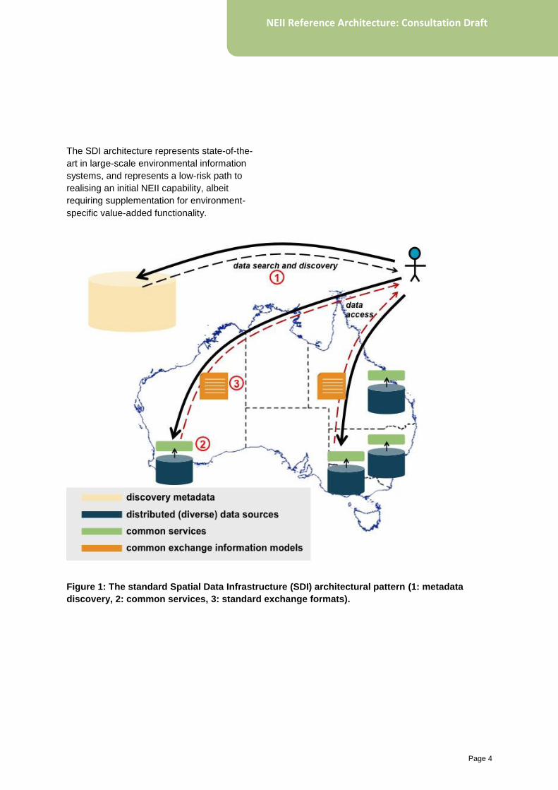
SDI pattern (Figure 1) allows a distributed
network of datasets to be federated and
interoperable by conforming to common data
models and exchange formats, standard
network protocols and providing centralised
catalogues of uniform metadata descriptions.
NEII adopts key elements of this best-practice
and adds particular extensions to support the
unique requirements of environmental
information. Example extensions embedded in
the NEII architecture include explicit
information about environmental monitoring
sites, or methods used to observe the
environment (e.g. instrument type, protocol
and parameter).
Page 4
NEII Reference Architecture: Consultation Draft
The SDI architecture represents state-of-the-
art in large-scale environmental information
systems, and represents a low-risk path to
realising an initial NEII capability, albeit
requiring supplementation for environment-
specific value-added functionality.
Figure 1: The standard Spatial Data Infrastructure (SDI) architectural pattern (1: metadata
discovery, 2: common services, 3: standard exchange formats).
Page 5
NEII Reference Architecture: Consultation Draft
2.5 Scope
The scope of this document is to:
• describe basic high-level use cases
• classify important information types
• describe key architectural components and
interfaces
• identify implementation technology
options.
Jointly, these comprise the NEII Reference
Architecture. Describing the detailed solution
architecture for individual NEII components is
out of scope for this document.
2.6 Requirements
The essential requirement for NEII is to:
• enhance discovery of, and access to,
priority environmental information.
2.7 Assumptions
The following assumptions apply to the
National Environmental Information
Infrastructure in its first phase:
• NEII will be distributed in nature as it is
beyond the capacity of any single agency
including the Bureau, to warehouse all
priority environmental information in one
location.
• The Spatial Data Infrastructure
architecture pattern is extensible to
environmental information.
• The reference architecture, including any
technical reference implementations must
not be based on proprietary solutions and
should conform to relevant international
standards and best practice.
• Priority stakeholders which include both
providers and users of NEII services are
initially Australian Government.
Notwithstanding this, research
infrastructure and other initiatives provide
important national environmental
information sources and the value of the
NEII will extend to other groups.
• In the first phase of the initiative (2010–14)
the purpose is to develop and deploy the
foundation components; to document the
NEII architecture and begin testing it in a
small number of applied settings; and to
establish collaborations to develop and
deliver the strategy’s long-term objectives.
A fully operational NEII will not be
completed in this timeframe.
2.8 Constraints
A number of constraints influence the design of
the reference architecture. First, there is
explicit recognition that implementation will
proceed in stages. By analogy, the European
INSPIRE SDI implementation roadmap
extends over more than a decade. Similarly,
the Canadian SDI (CGDI) has taken 10 years
to reach a stage of maturity sufficient for
promoting its operational use. Over an
extended implementation timetable, best
practice evolves; this reference architecture
will need to evolve in parallel, while still
delivering value at an early stage. A related
constraint is that the architecture must be
resilient – it should support integration of
providers, for instance, at varying degrees of
maturity and conformance.
Second, a number of activities internationally
(e.g. NSF’s EarthCube, the European Shared
Environmental Information System, etc.) are
attempting to develop distributed
environmental information systems. The NEII
Reference Architecture must demonstrate
value with respect to peer initiatives to justify
its continued adoption into the future.
Page 6
NEII Reference Architecture: Consultation Draft
Third, there is significant momentum
internationally (especially by the UK and US
governments) behind semantic web and
linked-data technologies as an emerging
platform for publishing public sector
information in a domain-neutral manner (i.e.
across various sectors such as environment,
health, statistics and finance). While this
approach shows significant promise, NEII
cannot wait until these technologies are
proven. Therefore a two-pronged strategy will
be followed: the reference architecture will
adopt the current best-practice SDI pattern as
a lower-risk initial solution; in parallel, the
Bureau will take a leadership role across
Australian Government in trialling linked-data
approaches.
2.9 Principles
A number of foundation principles inform the
long-term vision for NEII. Where conflicts arise,
the reference architecture prioritises practical
considerations over aspirational principles to
deliver near-term value. The reference
architecture will evolve over time to reflect
feasibility, technological developments and
emerging user requirements.
2.9.1 Feasible and sustainable
The NEII architecture will be distributed where
possible, but centralised where necessary. It
must be feasible to build NEII, and cost-
effective to sustain it. NEII will succeed by
starting simply and growing in complexity. This
suggests maintaining data at source wherever
possible, reducing the cost of duplicating and
warehousing datasets into a central location
and providing adequate hardware, data
management processes and infrastructure,
and domain expertise. It must also be possible
to support centralised management and
delivery of priority data if available, or where
conformance to NEII standards, will not
otherwise be guaranteed.
2.9.2 Standards-based
To minimise technical risks, NEII will follow
existing best practice for spatial data
infrastructures (SDIs). This will not require
harmonisation of individual provider data
management infrastructures, but instead will
achieve a virtual harmonisation through
interoperability. Interoperability will be
achieved by adopting conventional standards
for metadata, web services, and data
exchange. Interoperability is a necessary, but
not sufficient, condition to achieve NEII’s
eventual aims. NEII will also conform to
standards regulated by government and the
central coordinating authority (Bureau). NEII
will work with the Office of the Australian
Government Information Commissioner
(OAIC), Australian Government Information
Management Office (AGIMO), data.gov.au, the
Office for Spatial Policy (OSP) and other
related technical standards bodies to ensure
conformance to standards.
2.9.3 Data re-usability and open licencing
To maximise re-use of data and information
products, it is essential that users can evaluate
their fitness for purpose. This requires
traceable quality indicators to be associated to
datasets. There are a number of international
quality frameworks for environmental and earth
observations EO data (e.g. ISO/DIS 19157,
QA4EO) that may be relevant for NEII. The
marginal additional cost of including this
information at collection can significantly
enhance data re-usability. Re-usability is also
enhanced through a common licensing
framework. In line with the OAIC Principles on
Open Public Sector Information, a Creative
Commons Attribution (CC-BY) licence is
Page 7
NEII Reference Architecture: Consultation Draft
preferred for NEII, with a wider spectrum of
options available if necessary through
AusGOAL. NEII will provide a mechanism to
support re-use of public sector information
(PSI).
2.9.4 Multi-purpose
While the initial focus of NEII is on Australian
Government priorities for environmental
information, the infrastructure will ultimately
support a much broader spectrum of users –
including the research community and general
public. NEII should serve multiple purposes
across a varied environmental information
stakeholder community. It may be appropriate
to develop policies and mechanisms for NEII to
provide differentiated service offerings.
2.9.5 An agile infrastructure
NEII will enable environmental information to
be found, accessed, integrated, compared, and
used in new ways. This may be encapsulated
in the notion of an agile information platform.
First, it should be easy to publish into, and
access information from NEII. Data providers
should not need to substantially re-engineer
their existing data infrastructures, but be able
to easily register new datasets into NEII for
discovery and access by others. NEII should
be scalable with respect to both dataset
complexity and size (supporting big data). Data
and information products should be easily and
widely accessible across multiple delivery
channels. New data providers and users
should be supported at low overhead. NEII
should provide a platform to support
integration, correlation, and assimilation of
information products and services, including
computational models. Finally, as an
infrastructure, NEII should support a spectrum
of value-added applications and services that
may be constructed on its foundation.
2.9.6 Secure
NEII should provide secure access to data
providers and users. The security model
should support conventional authentication,
authorisation, and accounting services.
Page 8
NEII Reference Architecture: Consultation Draft
3.1 Use of RM-ODP
The NEII Reference Architecture defines a
general environmental information system, but
does not describe a specific deployment or
provider configuration. It adopts the Reference
Model for Open Distributed Processing (RM-
ODP) as an architectural framework (www.rm-
odp.net/), with the following benefits:
• RM-ODP is widely used internationally for
describing SDI architectures
• It is also adopted as a framework for
geospatial and SDI-related international
standards (ISO TC211 and the Open
Geospatial Consortium).
The RM-ODP framework factors an architecture
description into five complementary viewpoints:
1. Enterprise: defining the purpose, scope and
policies of the system
2. Information: describing the semantics of
information and information processing
within the system
3. Computational: decomposing the system
into computational interfaces
4. Engineering: describing the system
infrastructure and mechanisms supporting
distribution
5. Technology: focusing on technology
choices to realise the system.
3 Architectural overview
Page 9
NEII Reference Architecture: Consultation Draft
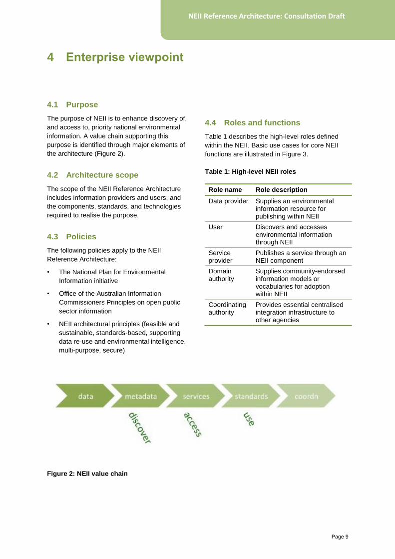
4.1 Purpose
The purpose of NEII is to enhance discovery of,
and access to, priority national environmental
information. A value chain supporting this
purpose is identified through major elements of
the architecture (Figure 2).
4.2 Architecture scope
The scope of the NEII Reference Architecture
includes information providers and users, and
the components, standards, and technologies
required to realise the purpose.
4.3 Policies
The following policies apply to the NEII
Reference Architecture:
• The National Plan for Environmental
Information initiative
• Office of the Australian Information
Commissioners Principles on open public
sector information
• NEII architectural principles (feasible and
sustainable, standards-based, supporting
data re-use and environmental intelligence,
multi-purpose, secure)
4.4 Roles and functions
Table 1 describes the high-level roles defined
within the NEII. Basic use cases for core NEII
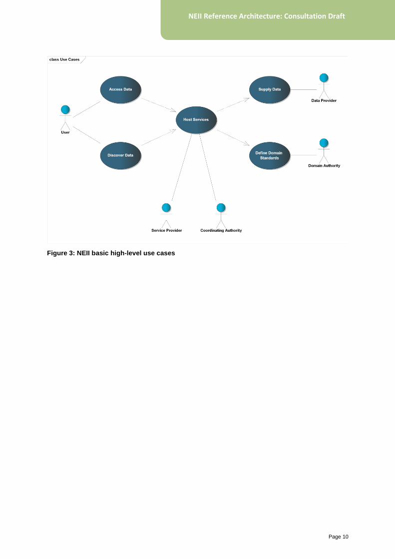
functions are illustrated in Figure 3.
Table 1: High-level NEII roles
Role name Role description
Data provider Supplies an environmental information resource for publishing within NEII
User Discovers and accesses environmental information through NEII
Service provider
Publishes a service through an NEII component
Domain authority
Supplies community-endorsed information models or vocabularies for adoption within NEII
Coordinating authority
Provides essential centralised integration infrastructure to other agencies
Figure 2: NEII value chain
4 Enterprise viewpoint
Page 10
NEII Reference Architecture: Consultation Draft
Figure 3: NEII basic high-level use cases
Page 11
NEII Reference Architecture: Consultation Draft
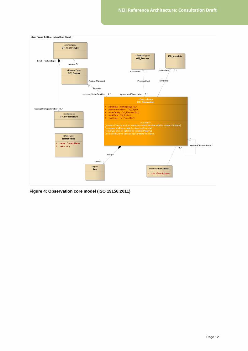
5.1 ISO 19156 Observations and Measurements model
ISO 19156:2011 defines a conceptual model for
observations and measurements (O&M) (Figure
4).
In natural language, the model states that an
environmental observation measures an
observed property of (or on) a feature-of-interest
using a procedure and generating a result. The
feature-of-interest may be a so-called domain
feature, reflecting a real-world object measured
in its entirety (river, bio-region, soil zone, etc.),
or more usually a sampling feature arising as an
artefact from an observing strategy (e.g.
stations, profiles, transects, etc.).
The O&M model is generally used as a
conceptual basis for standardised exchange
formats for environmental information types for
example: GeoSciML, WaterML and CSML.
However, within the NEII Reference
Architecture, O&M informs the definition of
individual architectural components and
classification of broad information classes (see
Table 2), whether or not it is also adopted for
standardised information exchange models
within the infrastructure. It provides a conceptual
foundation for the architecture as a whole,
beyond the standard SDI pattern. The NEII
Reference Architecture, therefore, represents an
O&M-based extension to SDI.
Table 2: Observations and Measurements
and NEII architecture
O&M element
NEII engineering component
NEII broad information class
observed property
Vocabulary service
Environmental parameters
feature-of-interest
Monitoring sites register
Information services
Monitoring sites & networks
Environmental geographies
procedure Observing methods register
Observing methods
result Information services
Information models
Integration between the various components
and information types is required to realise the
maximum value of the architecture. This
integration is achieved most readily by adoption
of O&M-based information exchange models.
The architecture is not reliant on O&M to
achieve information exchange and integration
can be completed through ad-hoc mechanisms
(e.g. manual spatial analysis for relating
monitoring sites to geographies).
5 Information viewpoint
Page 12
NEII Reference Architecture: Consultation Draft
Figure 4: Observation core model (ISO 19156:2011)
Page 13
NEII Reference Architecture: Consultation Draft
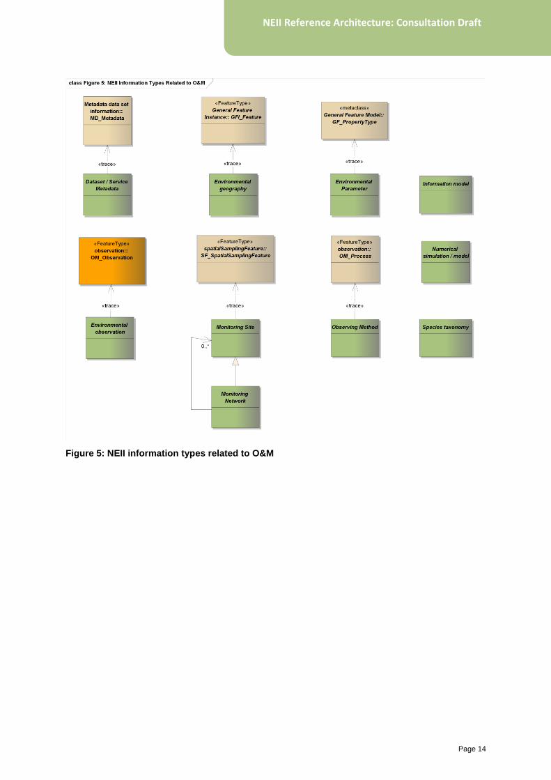
5.2 Information types
Figure 5 illustrates the classification of high-level
information types defined in NEII, and their
relationship to O&M.
Table 3 lists relevant standards for the
information types adopted in NEII.
Table 3: Relevant standards for NEII
information classes
NEII information class
Relevant standard ([M]andatory | [P]referred)
Dataset/service metadata
Profile of ISO 19115:2003 (Metadata) [M]
Environmental observations
ISO 19156:2011 (Observations and Measurements) [P]
Information models
Based on the General Feature Model, ISO 19109:2005 (Rules for Application Schemas) [M]
Environmental parameters/observables
Simple Knowledge Organisation System (SKOS) [M]
Monitoring sites and networks
--
Gridded data --
Environmental geographies
--
Observing methods
--
Species taxonomies
Simple Knowledge Organisation System (SKOS) [P]
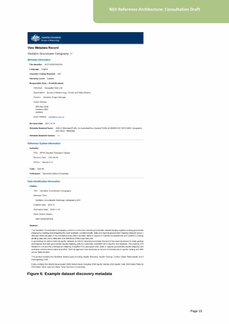
5.2.1 Dataset and service metadata
Dataset and service discovery metadata is
descriptive information about a discrete
environmental information data resource or
network-accessible service. It defines
standardised attributes useful for user searching
and filtering, for example (and see Figure 6):
• title and abstract
• reference date
• point of contact
• geographic extent of data
• thematic topic category
• on-line resource
• keywords.
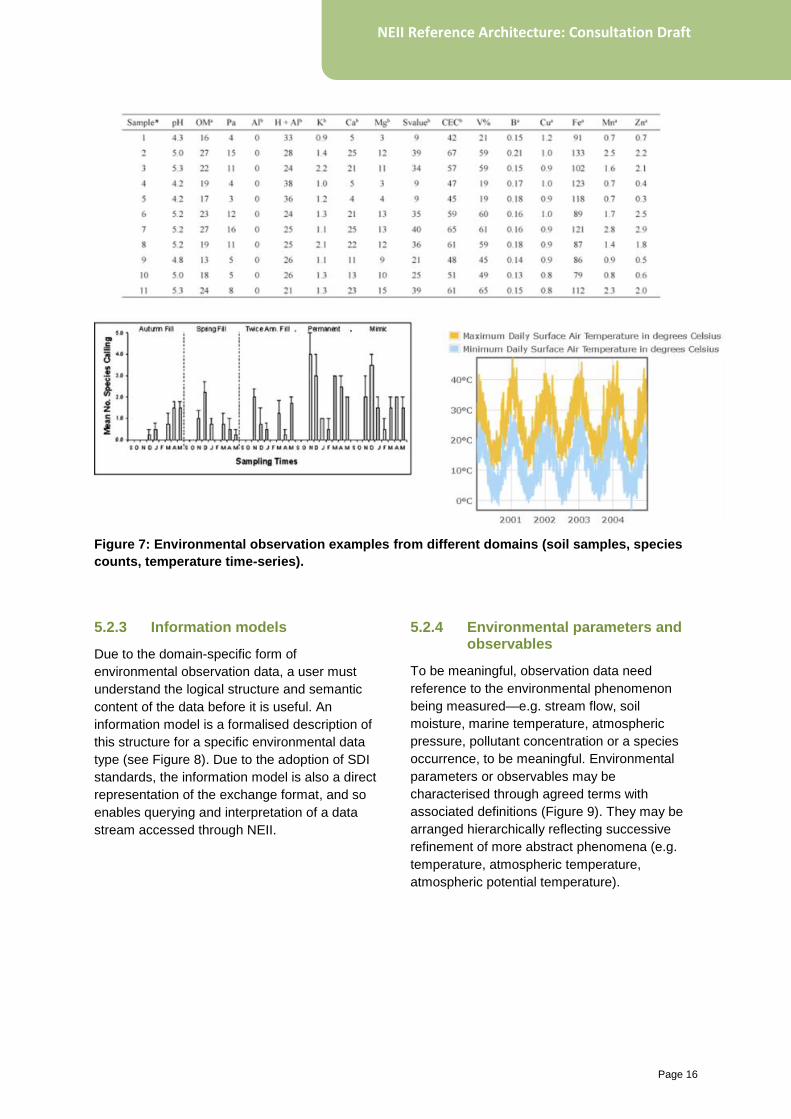
5.2.2 Environmental observations
Environmental observation data often represent
the ultimate target of a user search process. It is
the result of observing or measuring one or
more environmental parameters using a relevant
procedure within a geographic context and
temporal frame. The form of observation data is
domain-specific (Figure 7). Typical examples
include time-series, field samples and surveys,
profiles and transects.
Page 14
NEII Reference Architecture: Consultation Draft
Figure 5: NEII information types related to O&M
Page 15
NEII Reference Architecture: Consultation Draft
Figure 6: Example dataset discovery metadata
Page 16
NEII Reference Architecture: Consultation Draft
Figure 7: Environmental observation examples from different domains (soil samples, species
counts, temperature time-series).
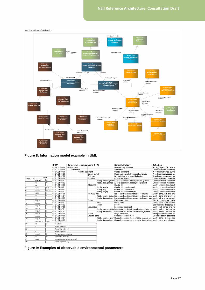
5.2.3 Information models
Due to the domain-specific form of
environmental observation data, a user must
understand the logical structure and semantic
content of the data before it is useful. An
information model is a formalised description of
this structure for a specific environmental data
type (see Figure 8). Due to the adoption of SDI
standards, the information model is also a direct
representation of the exchange format, and so
enables querying and interpretation of a data
stream accessed through NEII.
5.2.4 Environmental parameters and observables
To be meaningful, observation data need
reference to the environmental phenomenon
being measured—e.g. stream flow, soil
moisture, marine temperature, atmospheric
pressure, pollutant concentration or a species
occurrence, to be meaningful. Environmental
parameters or observables may be
characterised through agreed terms with
associated definitions (Figure 9). They may be
arranged hierarchically reflecting successive
refinement of more abstract phenomena (e.g.
temperature, atmospheric temperature,
atmospheric potential temperature).
Page 17
NEII Reference Architecture: Consultation Draft
Figure 8: Information model example in UML
Figure 9: Examples of observable environmental parameters
Page 18
NEII Reference Architecture: Consultation Draft
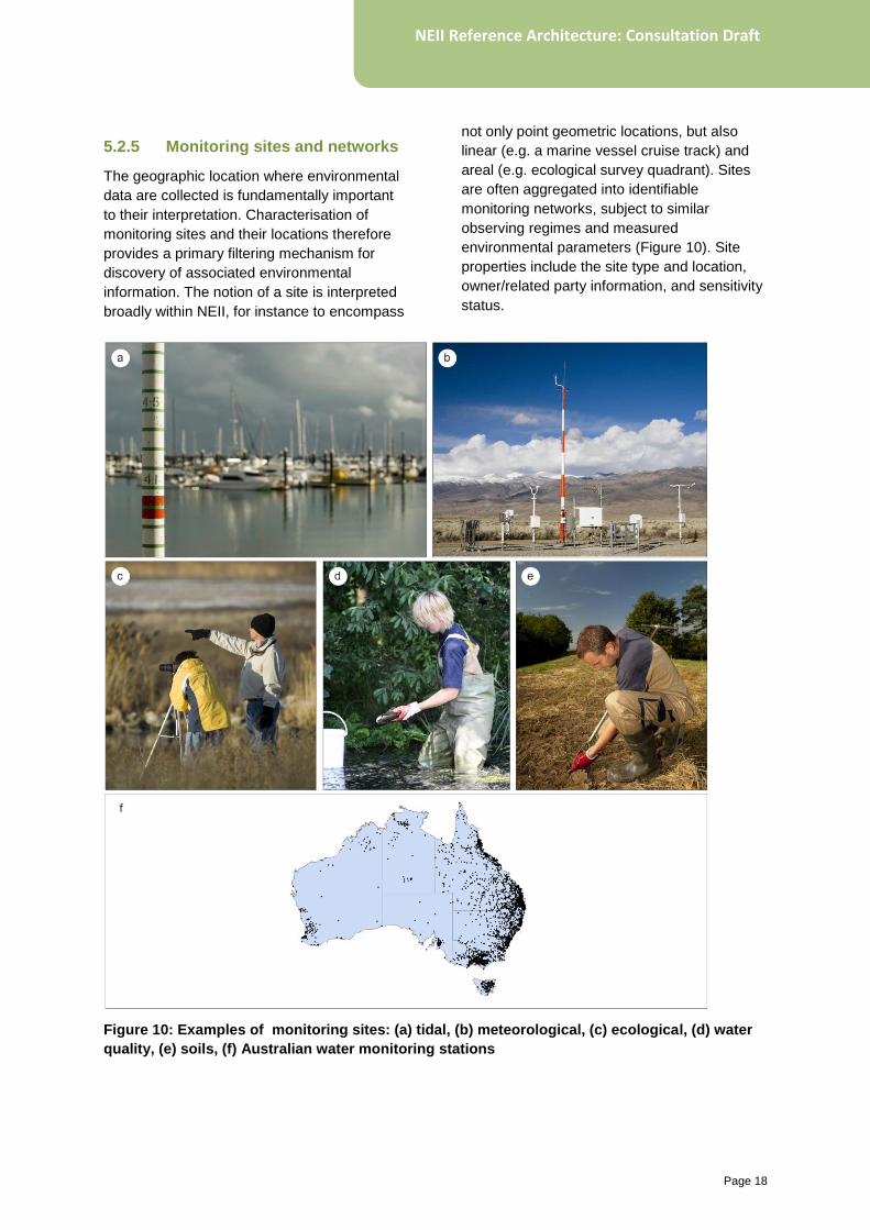
5.2.5 Monitoring sites and networks
The geographic location where environmental
data are collected is fundamentally important
to their interpretation. Characterisation of
monitoring sites and their locations therefore
provides a primary filtering mechanism for
discovery of associated environmental
information. The notion of a site is interpreted
broadly within NEII, for instance to encompass
not only point geometric locations, but also
linear (e.g. a marine vessel cruise track) and
areal (e.g. ecological survey quadrant). Sites
are often aggregated into identifiable
monitoring networks, subject to similar
observing regimes and measured
environmental parameters (Figure 10). Site
properties include the site type and location,
owner/related party information, and sensitivity
status.
Figure 10: Examples of monitoring sites: (a) tidal, (b) meteorological, (c) ecological, (d) water
quality, (e) soils, (f) Australian water monitoring stations
Page 19
NEII Reference Architecture: Consultation Draft
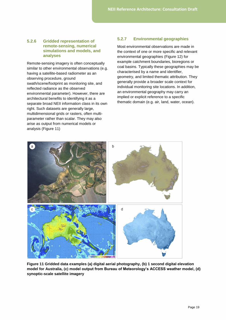
5.2.6 Gridded representation of remote-sensing, numerical simulations and models, and analyses
Remote-sensing imagery is often conceptually
similar to other environmental observations (e.g.
having a satellite-based radiometer as an
observing procedure, ground
swath/scene/footprint as monitoring site, and
reflected radiance as the observed
environmental parameter). However, there are
architectural benefits to identifying it as a
separate broad NEII information class in its own
right. Such datasets are generally large,
multidimensional grids or rasters, often multi-
parameter rather than scalar. They may also
arise as output from numerical models or
analysis (Figure 11)
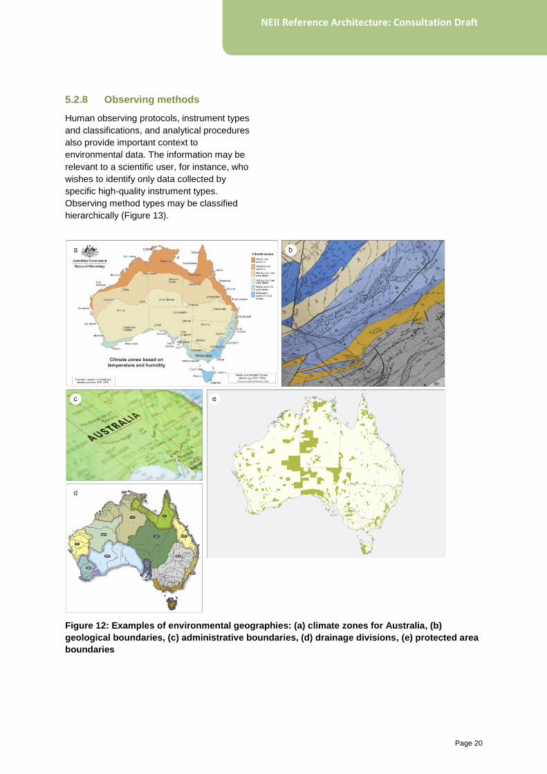
5.2.7 Environmental geographies
Most environmental observations are made in
the context of one or more specific and relevant
environmental geographies (Figure 12) for
example catchment boundaries, bioregions or
coal basins. Typically these geographies may be
characterised by a name and identifier,
geometry, and limited thematic attribution. They
generally provide a broader scale context for
individual monitoring site locations. In addition,
an environmental geography may carry an
implied or explicit reference to a specific
thematic domain (e.g. air, land, water, ocean).
Figure 11 Gridded data examples (a) digital aerial photography, (b) 1 second digital elevation
model for Australia, (c) model output from Bureau of Meteorology’s ACCESS weather model, (d)
synoptic-scale satellite imagery
Page 20
NEII Reference Architecture: Consultation Draft
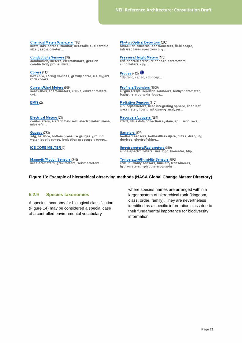
5.2.8 Observing methods
Human observing protocols, instrument types
and classifications, and analytical procedures
also provide important context to
environmental data. The information may be
relevant to a scientific user, for instance, who
wishes to identify only data collected by
specific high-quality instrument types.
Observing method types may be classified
hierarchically (Figure 13).
Figure 12: Examples of environmental geographies: (a) climate zones for Australia, (b)
geological boundaries, (c) administrative boundaries, (d) drainage divisions, (e) protected area
boundaries
Page 21
NEII Reference Architecture: Consultation Draft
Figure 13: Example of hierarchical observing methods (NASA Global Change Master Directory)
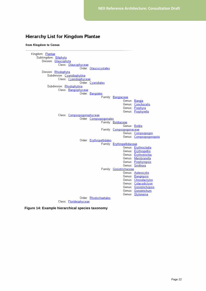
5.2.9 Species taxonomies
A species taxonomy for biological classification
(Figure 14) may be considered a special case
of a controlled environmental vocabulary
where species names are arranged within a
larger system of hierarchical rank (kingdom,
class, order, family). They are nevertheless
identified as a specific information class due to
their fundamental importance for biodiversity
information.
Page 22
NEII Reference Architecture: Consultation Draft
Figure 14: Example hierarchical species taxonomy
Page 23
NEII Reference Architecture: Consultation Draft
5.3 Information dynamics
The static information classes described above
define the key dimensions along which NEII
functionality is constructed. They provide a
structuring world view for environmental
information which creates a foundation for the
dynamic operation of the infrastructure (the form
behind NEII function). At the same time, there
are dynamic aspects of information flow that are
enabled through the NEII components: e.g.
federation of discovery metadata, data querying
and retrieval and information integration.
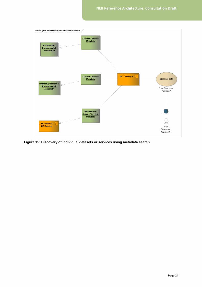
5.3.1 Environmental information querying
Since NEII extends the SDI pattern, the search
patterns enabled by conventional metadata
catalogues are explicitly supported, for example
the ability to discover individual discrete
datasets, data series or services. This enables
filtering by keyword, dataset geographic extent,
or topic category. The granularity supported
through this mechanism is constrained to that
imposed by data providers in populating
metadata records; discoverability is limited to
those defined datasets or services explicitly
described by a provider. It does not, for
instance, support discovery of user-driven
datasets combining data across multiple
providers (e.g. all groundwater pressure data
from boreholes from five agencies).
Figure 15 illustrates a data discovery scenario
with metadata records describing individual
datasets and services.
In extending the standard SDI approach, the
NEII Reference Architecture enables value-
added querying by:
• environmental parameter (for example, find
all marine salinity data)
• environmental geography (for example, find
all data related to the Channel Country
bioregion)
• monitoring site (for example, find all
observations from climate monitoring
stations).
Combination queries are also enabled (for
example, find all river-level data from gauging
stations in the Murray–Darling Basin).
Page 24
NEII Reference Architecture: Consultation Draft
Figure 15: Discovery of individual datasets or services using metadata search
Page 25
NEII Reference Architecture: Consultation Draft
5.3.2 Information integration and maintenance
To support the rich environmental information
discovery and query model enabled through
NEII, there must be integration between the
information types: monitoring sites must be
associated with environmental geographies and
annotated with available environmental
parameters. Linkages are needed to related
environmental observation datasets and their
discovery metadata descriptions (including
online services and information models).
The most scalable and sustainable mechanism
way to achieve this integration is through
configuring data provider services that supply
these relationships at source. This requires:
• adopting O&M-based information models
• establishing linkages at provider-level
between observational data, sites,
geographies, and observed parameters
• configuring web services to respect and
publish these relationships.
Each condition involves significant complexity,
and the full vision is many years away from
being realised. The NEII Reference Architecture
does not rely on full realisation of this vision to
deliver value and integration may be achieved
through ad-hoc mechanisms (e.g. spatial
analysis to determine the relationship of
monitoring sites to environmental geographies,
Section 7.6.1). The trade-off is with sustainability
as ad-hoc mechanisms are difficult to maintain.
The NEII Reference Architecture strikes a
balance enabling initial value in the absence of
mature implementation, but also encouraging
greater maturity to enhance sustainability of the
infrastructure.
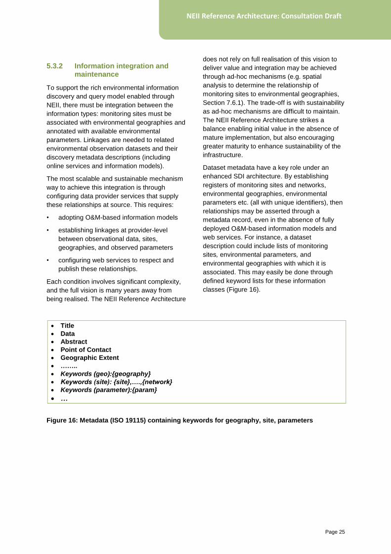
Dataset metadata have a key role under an
enhanced SDI architecture. By establishing
registers of monitoring sites and networks,
environmental geographies, environmental
parameters etc. (all with unique identifiers), then
relationships may be asserted through a
metadata record, even in the absence of fully
deployed O&M-based information models and
web services. For instance, a dataset
description could include lists of monitoring
sites, environmental parameters, and
environmental geographies with which it is
associated. This may easily be done through
defined keyword lists for these information
classes (Figure 16).
Title
Data
Abstract
Point of Contact
Geographic Extent
……..
Keywords (geo):{geography}
Keywords (site): {site},….,{network}
Keywords (parameter):{param}
…
Figure 16: Metadata (ISO 19115) containing keywords for geography, site, parameters

Page 26
NEII Reference Architecture: Consultation Draft
5.3.3 Metadata federation or harvesting
The standard SDI discovery scenario is
implemented across the infrastructure by
federating discovery metadata. Through use of
standard protocols, metadata from one data
provider may be aggregated with that from
another provider into a central metadata
catalogue enabling searching for datasets
across all contributing providers.
Page 27
NEII Reference Architecture: Consultation Draft
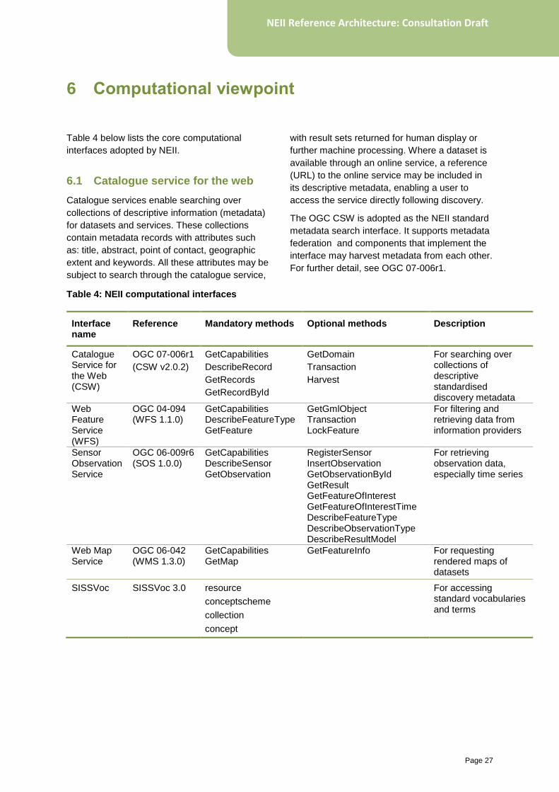
Table 4 below lists the core computational
interfaces adopted by NEII.
6.1 Catalogue service for the web
Catalogue services enable searching over
collections of descriptive information (metadata)
for datasets and services. These collections
contain metadata records with attributes such
as: title, abstract, point of contact, geographic
extent and keywords. All these attributes may be
subject to search through the catalogue service,
with result sets returned for human display or
further machine processing. Where a dataset is
available through an online service, a reference
(URL) to the online service may be included in
its descriptive metadata, enabling a user to
access the service directly following discovery.
The OGC CSW is adopted as the NEII standard
metadata search interface. It supports metadata
federation and components that implement the
interface may harvest metadata from each other.
For further detail, see OGC 07-006r1.
Table 4: NEII computational interfaces
Interface name
Reference Mandatory methods Optional methods Description
Catalogue Service for the Web (CSW)
OGC 07-006r1
(CSW v2.0.2)
GetCapabilities
DescribeRecord
GetRecords
GetRecordById
GetDomain
Transaction
Harvest
For searching over collections of descriptive standardised discovery metadata
Web Feature Service (WFS)
OGC 04-094 (WFS 1.1.0)
GetCapabilities DescribeFeatureType GetFeature
GetGmlObject Transaction LockFeature
For filtering and retrieving data from information providers
Sensor Observation Service
OGC 06-009r6 (SOS 1.0.0)
GetCapabilities DescribeSensor GetObservation
RegisterSensor InsertObservation GetObservationById GetResult GetFeatureOfInterest GetFeatureOfInterestTime DescribeFeatureType DescribeObservationType DescribeResultModel
For retrieving observation data, especially time series
Web Map Service
OGC 06-042 (WMS 1.3.0)
GetCapabilities GetMap
GetFeatureInfo For requesting rendered maps of datasets
SISSVoc SISSVoc 3.0 resource
conceptscheme
collection
concept
For accessing standard vocabularies and terms
6 Computational viewpoint
Page 28
NEII Reference Architecture: Consultation Draft
The core operations defined are:
• GetCapabilities: Returns descriptive
information (service metadata) about the
specific metadata catalogue being queried.
The response includes information on:
o identification information for the
service (CSW version supported,
title, access constraints, etc.)
o service provider (including name
and contact person)
o operations metadata (supported
operations and required
parameters)
o filter capabilities (the filtering
operations supported for metadata
search – logical, spatial, comparison
operators).
• DescribeRecord: Describes the schema
structure of metadata records supported by
the catalogue; for NEII this is a profile of ISO
19115.
• GetRecords: The core search operation;
retrieves metadata records matching a
selection filter specified in the request.
Filtering is performed against the supported
record schema using the advertised filtering
capabilities and typically constraints
(logical, spatial, comparison) may be
specified against individual schema
elements. The result set may be returned
complete, or passed through a projection
process returning a reduced set of schema
elements for each record (e.g. brief,
summary, or full records may be returned).
• GetRecordById: Similar to GetRecords, but
returns only specific records requested by
their identifiers (rather than a full filter-based
search).
6.2 Web Feature Service
The ‘General Feature Model’ has been adopted
by the standards bodies ISO TC211 and OGC
as an abstract foundation to their standards
programs. This model regards any real-world
information object (or feature) as having identity,
a type, attributes, and associations with other
objects. Feature types may derive from one
another (by extension or restriction). The
General Feature Model is essentially an object-
based meta-model for real-world information
entities. The Web Feature Service, then, acts as
a general query interface against an opaque
feature store (or database of information
objects). It may be applied for any environmental
information type for which an information model
is defined.
The OGC standard WFS is therefore adopted by
NEII as the core general data querying and
retrieval interface. Full details are available in
OGC 04-094.
The core operations defined are:
• GetCapabilities: Returns descriptive
information (service metadata) about the
specific feature service being queried. The
response includes information on:
o Identification information for the
service (WFS version supported,
title, access constraints)
o service provider (including service
provider name and contact person)
o operations metadata (supported
operations and required
parameters)
o feature types (a list of the feature
types available from the service)
o filter capabilities (the filtering
operations supported for feature
querying logical, spatial, arithmetic,
comparison operators)
• DescribeFeatureType: Describes the
schema structure of feature types available
from the service.
• GetFeature: The core query operation;
retrieves features (information objects) from
the feature store (database) based on
matching against filter parameters specified
in the request. At minimum a specific named
feature type must be requested, however
Page 29
NEII Reference Architecture: Consultation Draft
WFS supports very rich filtering capabilities,
described in OGC 04-095. Both selection
(matching features to return based on
specified filter constraints) and projection
(choosing which information elements of
matching features to include in the
response) are supported.
6.3 Sensor Observation Service
The ISO 19156:2011 Observations and
Measurements model defines a general
conceptual model for the observation process,
applicable across the full range of observation
types. It is one of a family of sensor web
standards developed by OGC and ISO TC211.
O&M follows the General Feature Model,
modelling observations as features. Therefore
the WFS interface may be used, in principle, for
accessing observation data. However there are
benefits to adopting a specialised interface
specifically for the special case of observational
data:
• client queries are simpler to construct; and
• time-series observations may be handled in
a more straightforward manner.
The Sensor Observation Service enables
specialised queries aligned with the O&M model
for observational data sources that conform to it.
Observations are grouped together within a
service into observation offerings – collections of
observations over a specified time period
(historical or real-time) with a shared set of
observing procedures, observed properties, and
features subject to observation. A user may
reasonably expect observations to be dense
within the parameter space of a given offering –
i.e. most combinations of procedure, observed
property, feature-of-interest, and time period
should provide available observations. This
heuristic provides useful guidance in configuring
observation offerings within a service.
The adoption of the SOS interface in NEII is
limited to querying observational time series
data. It may be adopted for observation data
more generally as available implementations
mature. The interface is described in detail in
OGC 06-009r6.
The core operations defined are:
• GetCapabilities: Returns descriptive
information (service metadata) about the
specific observation service being queried.
The response includes information on:
o identification information for the
service (SOS version supported,
title, access constraints,)
o service provider (including name
and contact person)
o filter capabilities (the filtering
operations supported for
observation querying and logical,
spatial, arithmetic, comparison
operators)
o contents (a list of observation
offerings available from the service)
• DescribeSensor: Provides a description of
specific observing procedures (sensors or
sensor systems), generally using SensorML
for the response.
• GetObservation: The core observation
request operation; retrieves observations
from a specific observation offering
according to request parameters. The
operation allows filtering against the O&M
model by specifying one or more required
observed properties, and optionally
observation times (or time periods),
observation procedures, and features-of-
interest. The response contains matching
observations encoded with the O&M
schema [OGC 10-025r1] (or a derivation, for
observation models based on O&M).
6.4 Web Map Service
A user does not always require direct access to
environmental data itself, but may instead prefer
a rendered map of the data. The Web Map
Service interface supports this, returning a
rendered portrayal over some geographic region
of an information layer (typically a specific
Page 30
NEII Reference Architecture: Consultation Draft
feature type). The rendered map is constructed
following the request parameters – with a
specific Coordinate Reference System or map
projection, rendering style, and image format
and size.
NEII adopts the OGC WMS interface for
requesting mapped environmental information.
Full details are described in OGC 06-042.
The core operations defined are:
• GetCapabilities: Returns descriptive
information (service metadata) about the
specific map service being queried. The
response includes information on:
o identification information for the
service (WMS version supported,
title and access constraints)
o service provider (including name
and contact person)
o operations metadata (supported
operations and required
parameters)
o map layers (descriptions of all layers
available; including name, title,
available styles, geographic
bounding box, and supported output
format.).
• GetMap: A rendered map is returned in
response to this request. The request must
include required layers and styles,
coordinate reference system, geographic
bounding box, and width, height, and format
of returned image file.
6.5 SISSVoc (Vocabulary Service)
Standardised vocabularies (e.g. for marine
environmental parameters, soil types, lithology,
species names) are a cornerstone for enabling
interoperable environmental information
exchange (i.e. where the information is able to
be understood and used). In order to adopt
standardised vocabulary terms, they must be
defined, governed, and able to be referenced.
The SISSVoc interface enables vocabularies
and terms to be resolved and their definitions
retrieved. Vocabularies, their terms and term
definitions are structured following the W3C
standard SKOS (Simple Knowledge
Organisation System). This supports the
construction of both hierarchical terms (SKOS
concepts) and simple code lists of terms (SKOS
collections), and aggregated into named
vocabularies (SKOS concept schemes). All
items (vocabularies, code lists, terms) are
identified by URI, have a text-based label and
may have a description.
NEII adopts SISSVoc 3.0 as a vocabulary
resolution interface. Details are available on the
SEEGrid wiki
(www.seegrid.csiro.au/wiki/Siss/SISSvoc30API).
SISSVoc continues to be developed, with future
support for publishing information models in
addition to vocabularies.
The core operations defined are:
• conceptscheme: Returns a list of all
available concept schemes (i.e.
vocabularies) known by the vocabulary
service.
• collection: Returns a list of all available
concept collections (e.g. code lists) within a
vocabulary.
• concept: Returns a list of all vocabulary
concepts (vocabulary terms), or of those
broader or narrower in meaning to a specific
concept within a hierarchy. Concepts are
referenced by their URI identifier, but may
also be specified by matching against their
text-based labels.
• resource: Returns a description of a
specific vocabulary term (or other item)
referenced by URI identifier.
Page 31
NEII Reference Architecture: Consultation Draft
Environmental information resources in NEII are
distributed across nodes, geography and
organisations. This distribution is achieved by
defining specific architectural components which
may be deployed across nodes, and which
ensure the proper functioning of the
infrastructure as a whole.
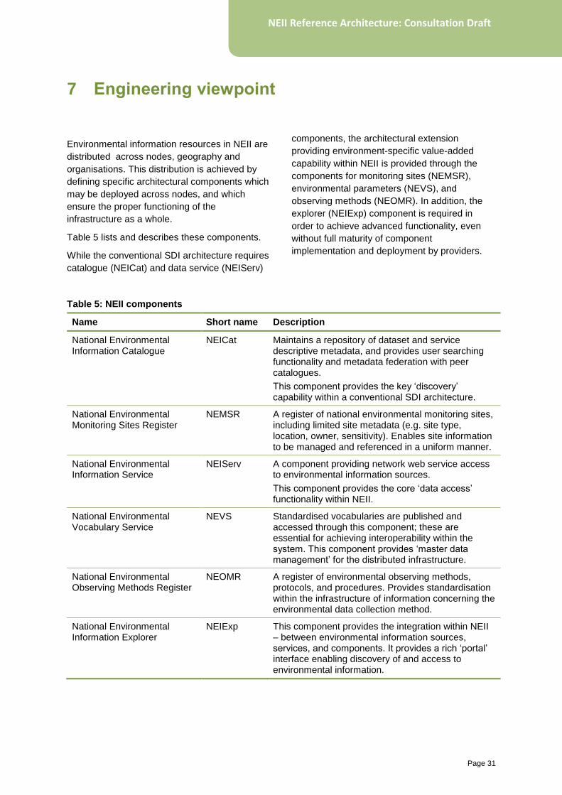
Table 5 lists and describes these components.
While the conventional SDI architecture requires
catalogue (NEICat) and data service (NEIServ)
components, the architectural extension
providing environment-specific value-added
capability within NEII is provided through the
components for monitoring sites (NEMSR),
environmental parameters (NEVS), and
observing methods (NEOMR). In addition, the
explorer (NEIExp) component is required in
order to achieve advanced functionality, even
without full maturity of component
implementation and deployment by providers.
Table 5: NEII components
Name Short name Description
National Environmental Information Catalogue
NEICat Maintains a repository of dataset and service descriptive metadata, and provides user searching functionality and metadata federation with peer catalogues.
This component provides the key ‘discovery’ capability within a conventional SDI architecture.
National Environmental Monitoring Sites Register
NEMSR A register of national environmental monitoring sites, including limited site metadata (e.g. site type, location, owner, sensitivity). Enables site information to be managed and referenced in a uniform manner.
National Environmental Information Service
NEIServ A component providing network web service access to environmental information sources.
This component provides the core ‘data access’ functionality within NEII.
National Environmental Vocabulary Service
NEVS Standardised vocabularies are published and accessed through this component; these are essential for achieving interoperability within the system. This component provides ‘master data management’ for the distributed infrastructure.
National Environmental Observing Methods Register
NEOMR A register of environmental observing methods, protocols, and procedures. Provides standardisation within the infrastructure of information concerning the environmental data collection method.
National Environmental Information Explorer
NEIExp This component provides the integration within NEII – between environmental information sources, services, and components. It provides a rich ‘portal’ interface enabling discovery of and access to environmental information.
7 Engineering viewpoint
Page 32
NEII Reference Architecture: Consultation Draft
7.1 National Environmental Information Catalogue (NEICat)
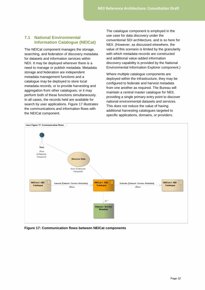
The NEICat component manages the storage,
searching, and federation of discovery metadata
for datasets and information services within
NEII. It may be deployed wherever there is a
need to manage or publish metadata. Metadata
storage and federation are independent
metadata management functions and a
catalogue may be deployed to store local
metadata records, or to provide harvesting and
aggregation from other catalogues; or it may
perform both of these functions simultaneously.
In all cases, the records held are available for
search by user applications. Figure 17 illustrates
the communications and information flows with
the NEICat component.
The catalogue component is employed in the
use case for data discovery under the
conventional SDI architecture, and is so here for
NEII. (However, as discussed elsewhere, the
value of this scenario is limited by the granularity
with which metadata records are constructed
and additional value-added information
discovery capability is provided by the National
Environmental Information Explorer component.)
Where multiple catalogue components are
deployed within the infrastructure, they may be
configured to federate and harvest metadata
from one another as required. The Bureau will
maintain a central master catalogue for NEII,
providing a single primary entry point to discover
national environmental datasets and services.
This does not reduce the value of having
additional harvesting catalogues targeted to
specific applications, domains, or providers.
Figure 17: Communication flows between NEICat components
Page 33
NEII Reference Architecture: Consultation Draft
7.2 National Environmental Monitoring Sites Register (NEMSR)
Environmental monitoring sites are a
fundamental dimension of environmental
information (e.g. for structuring discovery and
access) across almost all domains of
environmental activity. There are several
benefits to maintaining explicit registers of
monitoring sites:
• facilitating high-level analysis of the overall
national environmental monitoring portfolio
• enabling uniform site-based discovery and
access to observation data
• enabling standardisation of site metadata
across multiple environmental domains
within the infrastructure.
The NEMSR component is dedicated to
managing site information within NEII. In a fully
mature infrastructure (with O&M-based
information models widely adopted and
deployed) monitoring site information may be
queried dynamically directly through provider
information services. In this case, the role of
NEMSR may be no more than a strong forward
cache of site information (i.e. maintained
externally or forward from data providers, but
with strong consistency to source); it will provide
important performance benefits, and perhaps a
standardisation of site information, but no
fundamentally novel functionality. However, in
the absence of fully-developed information
services, the component plays a critical role for
integration of data services with sites.
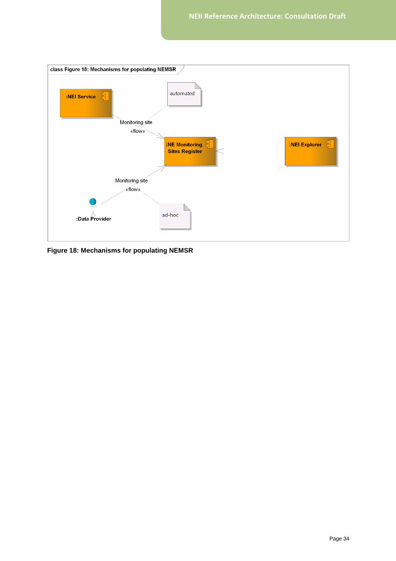
Figure 18 shows the two means of populating
NEMSR, and its use by NEI Explorer. For
information services providing access to site
information through O&M-based information
models, an automated process may be used to
ingest site metadata into NEMSR. In other
cases, ad-hoc processes are required to obtain
site metadata, usually directly from data
providers. Once populated, NEMSR may be
used by NEI Explorer to provide site-based
discovery and configure links to associated
information services.
Page 34
NEII Reference Architecture: Consultation Draft
Figure 18: Mechanisms for populating NEMSR
Page 35
NEII Reference Architecture: Consultation Draft
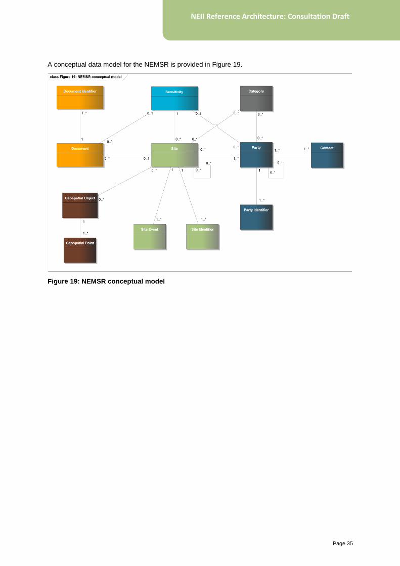
A conceptual data model for the NEMSR is provided in Figure 19.
Figure 19: NEMSR conceptual model
Page 36
NEII Reference Architecture: Consultation Draft
7.3 National Environmental Information Service (NEIServ)
Beyond data discovery, real value is provided in
NEII by enabling access to environmental
information sources directly by users and
applications. In order to achieve this with any
benefit beyond existing ad-hoc data access
mechanisms (usually non-standard, and
provider-specific), a standardised access
mechanism must be provided to users. The NEI
Service component provides uniform and
standards-based data query and retrieval
functionality, and may be deployed by data or
(on their behalf) service providers. It initially
provides access to the following NEII information
types:
• environmental observations
• environmental geographies
• gridded representation of remote sensing,
numerical simulations and model data.
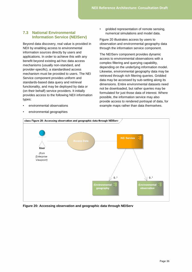
Figure 20 illustrates access by users to
observation and environmental geography data
through the information service component.
The NEIServ component provides dynamic
access to environmental observations with a
complex filtering and querying capability,
depending on the underlying information model.
Likewise, environmental geography data may be
retrieved through rich filtering queries. Gridded
data may be accessed by sub-setting along its
dimensions. Entire environmental datasets need
not be downloaded, but rather queries may be
formulated for just those data of interest. Where
possible, the information service may also
provide access to rendered portrayal of data, for
example maps rather than data themselves.
Figure 20: Accessing observation and geographic data through NEIServ
Page 37
NEII Reference Architecture: Consultation Draft
7.4 National Environmental Vocabulary Service (NEVS)
Information interoperability depends on
achieving a common understanding and
interpretation of data exchanged – for instance
ensuring that water quality data providers adopt
common terminology for chemical species and
pollutants. To achieve this requires adoption of
standardised vocabularies within NEII. Even
where only a single provider is responsible for a
given environmental domain (with no need for
harmonisation across multiple providers),
adoption of standardised terms is required for
users to accurately interpret published data.
Generally, there is a separation between
governance of terminology and vocabularies,
and provision of infrastructure for publishing and
using agreed standard terms. A ‘Domain
Authority’ may regulate standard terms and
definitions for a specific environmental domain,
while not having the technical capacity to publish
those standards. In practice, standard
vocabularies are often published in physical
books, or opaque electronic (e.g. PDF)
documents. Even where more machine-readable
formats (e.g. CSV) are used there is no
standardisation of structure across different
domains. This leads to difficulty within
integrating infrastructures like NEII.
The National Environmental Vocabulary Service
provides a uniform mechanism within NEII for
publishing standardised vocabularies. It
supports the ability to:
• query available vocabularies and terms; and
• identify and navigate hierarchies of terms
(e.g. land-use classifications).
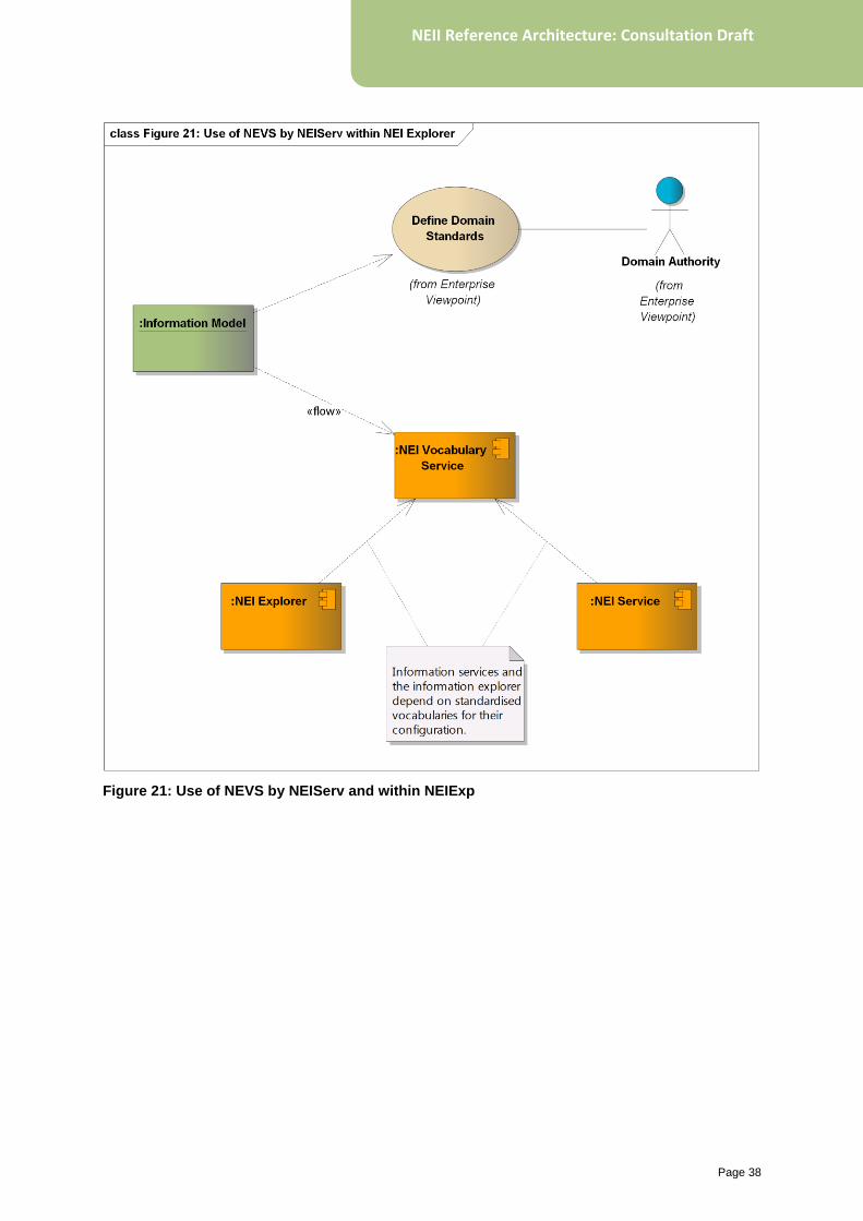
Figure 20 shows the role of the vocabulary
service in supporting configuration of information
services and the NEI Explorer. While there are
many examples of standard vocabularies
required within NEII, this diagram illustrates a
typical scenario of vocabularies associated with
standard information models. Environmental
parameters and species taxonomies are
concrete examples of vocabularies that may be
published through a vocabulary service. The
vocabulary service will eventually support
publishing of full information models, not only
vocabularies (e.g. code lists) associated with
them.
Page 38
NEII Reference Architecture: Consultation Draft
Figure 21: Use of NEVS by NEIServ and within NEIExp
Page 39
NEII Reference Architecture: Consultation Draft
7.5 National Environmental Observing Methods Register (NEOMR)
Observing methods are a fundamental
information type within NEII, and provide
important interpretive context for environmental
observation datasets—especially for ecological
data where the sampling/survey method is
critical for evaluating the fitness-for-purpose of
data. For the physical environmental sciences it
is often very useful to know the broad instrument
type or analysis method used to make a
measurement.
The National Environmental Observing Methods
Register will manage information related to the
procedure used to collect/generate data, e.g.:
• field / human observing protocols
• instrument classes and types
• lab/computer analytical methods.
By establishing an online electronic register of
observing methods (survey protocols, instrument
types, analysis methods), datasets may be
cross-referenced to provide unambiguous
contextual information about the procedure used
to obtain the data. Conversely, for discovery,
available data may be filtered by the observing
method of interest.
The design of the National Environmental
Observing Methods register is subject to further
analysis, and currently planned for future
development. It will require a hierarchical
taxonomy or ontology of environmental
observing procedures, monitoring protocols,
analytical methods.
Examples of existing methods registries and/or
their use for search in different domains are
listed below. NEOMR will catalogue and present
such information in a unified manner.
• US National Environmental Methods Index:
www.nemi.gov
• The CEOS Catalogue of Satellite
Instruments:
http://database.eohandbook.com/database/i
nstrumenttable.aspx
• NASA Global Change Master Directory
index of datasets by instrument:
http://gcmd.nasa.gov/KeywordSearch/Keyw
ords.do?Portal=GCMD&MetadataType&Key
wordPath=Instruments
• UK Environmental Change Network
protocols for terrestrial and freshwater
observations:
www.ecn.ac.uk/measurements
• Environment Canada Ecological Monitoring
Protocols: www.ec.gc.ca/faunescience-
wildlifescience/default.asp?n=E19163B6-
1#Ecologicalmonitoringprotocols
• NSW Environment & Heritage Field survey
methods:
www.environment.nsw.gov.au/threatenedsp
ecies/surveymethodsfauna.htm
• SeaDataNet (largest pan-European marine
data infrastructure) supporting data search
by instrument type:
http://seadatanet.maris2.nl/v_cdi_v3/browse
_step.asp
• ACLEP Guidelines for Surveying Soil and
Land Resources (‘Blue Book’):
www.publish.csiro.au/nid/22/pid/5650.htm
Page 40
NEII Reference Architecture: Consultation Draft
7.6 National Environmental Information Explorer (NEIExp)
A basic premise of the SDI architecture on
which NEII is founded is that it implements a
distributed deployment model. Thus there is
minimal requirement for centralised
coordinating infrastructure. In principle the
infrastructure is scalable to easily support
integration of new providers, and to support
novel value-added applications. While a
primary user-centred portal is often provided
as a visible entry point to the infrastructure, this
by no means prevents the construction of other
portals or user interfaces. Since the distributed
components implement web-service based
interfaces, it is possible to integrate their
functionality within other applications and
services.
On the other hand, this model assumes a high
level of implementation maturity by providers.
For instance, the ability to access integrated
observation data of a particular type across
multiple providers requires them all to have
deployed standardised information services
conforming to rich information models and
supporting complex user filtering requests.
Consider the following user scenario: obtain all
stream flow measurements from gauging
stations in the Murray–Darling Basin between
2010 and 2012. In a fully mature infrastructure
this might proceed as follows:
1. Query on metadata catalogue for services
providing stream flow observation data
2. For each discovered service, request
observations between 2010 and 2012
where:
• The observation procedure is a ‘stream
flow gauge’,
• The observed property is ‘stream flow’,
and
• Either: the monitoring point explicitly
samples (through its ‘sampled feature’
property) the Murray–Darling Basin), or is
located within a user-supplied polygon
boundary for the Murray–Darling Basin.
A lot of machinery needs to be in place for this
to work: an O&M-based information model
must be adopted, services must be configured
with appropriate monitoring site metadata and
relationships to relevant geographies, standard
vocabularies must be agreed and adopted for
environmental parameters and observing
procedures. While this level of maturity is the
ultimate goal of NEII, for value to be realised in
the interim, ad-hoc mechanisms for configuring
these relationships are needed.
7.6.1 Integration index
The NEI Explorer provides sophisticated
faceted browse capability, allowing users to
navigate the broad spectrum of available
environmental information by successively
refining a selection along dimensions of:
• Monitoring site type and/or location
• Environmental parameter
• Associated environmental geography.
To implement this, a logical integration index
table is created within the NEI Explorer
enabling ad-hoc associations to be established
between monitoring sites, environmental
geographies, environmental parameters, and
information services (see Figure 22).
This enables the advanced faceted search and
discovery capability within NEII even in the
absence of fully-implemented complex O&M-
based information models. Even in the case of
mature (and fully-deployed) information
models, there are major performance benefits
to caching these relationships within the
information Explorer.
The main (and major) challenge is populating
the integration index and generally this must
proceed on an ad-hoc basis and is agency or
implementation specific. It should be noted that
such ad-hoc integration is not required for the
infrastructure to function and by default the
conventional SDI pattern still applies:
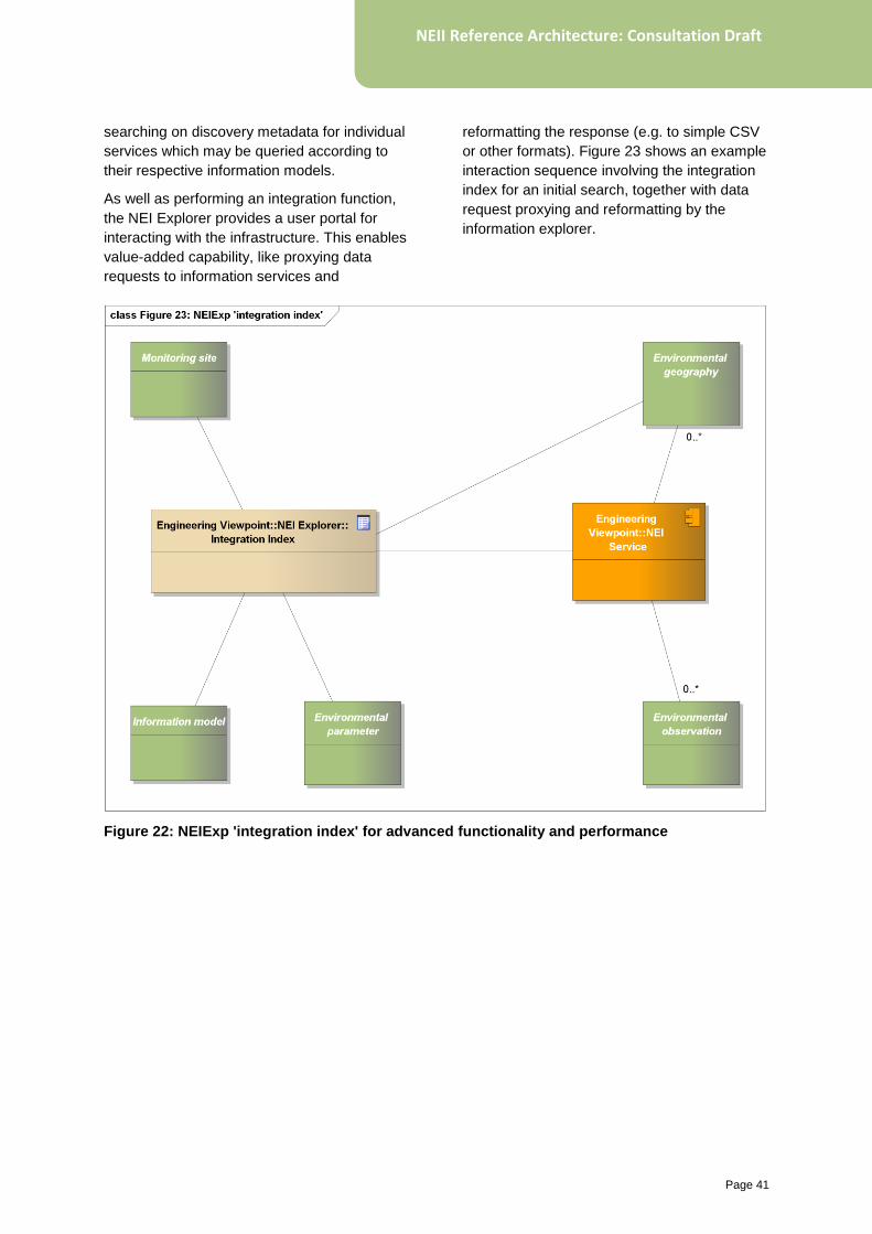
Page 41
NEII Reference Architecture: Consultation Draft
searching on discovery metadata for individual
services which may be queried according to
their respective information models.
As well as performing an integration function,
the NEI Explorer provides a user portal for
interacting with the infrastructure. This enables
value-added capability, like proxying data
requests to information services and
reformatting the response (e.g. to simple CSV
or other formats). Figure 23 shows an example
interaction sequence involving the integration
index for an initial search, together with data
request proxying and reformatting by the
information explorer.
Figure 22: NEIExp 'integration index' for advanced functionality and performance
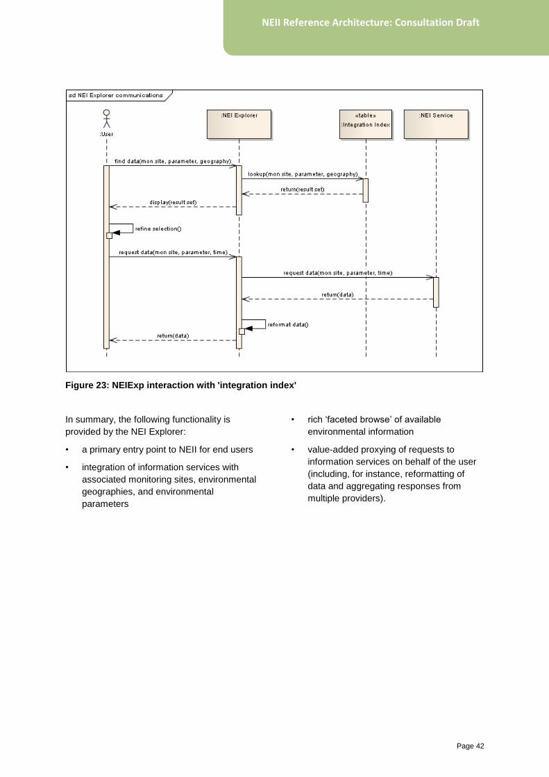
Page 42
NEII Reference Architecture: Consultation Draft
Figure 23: NEIExp interaction with 'integration index'
In summary, the following functionality is
provided by the NEI Explorer:
• a primary entry point to NEII for end users
• integration of information services with
associated monitoring sites, environmental
geographies, and environmental
parameters
• rich ‘faceted browse’ of available
environmental information
• value-added proxying of requests to
information services on behalf of the user
(including, for instance, reformatting of
data and aggregating responses from
multiple providers).
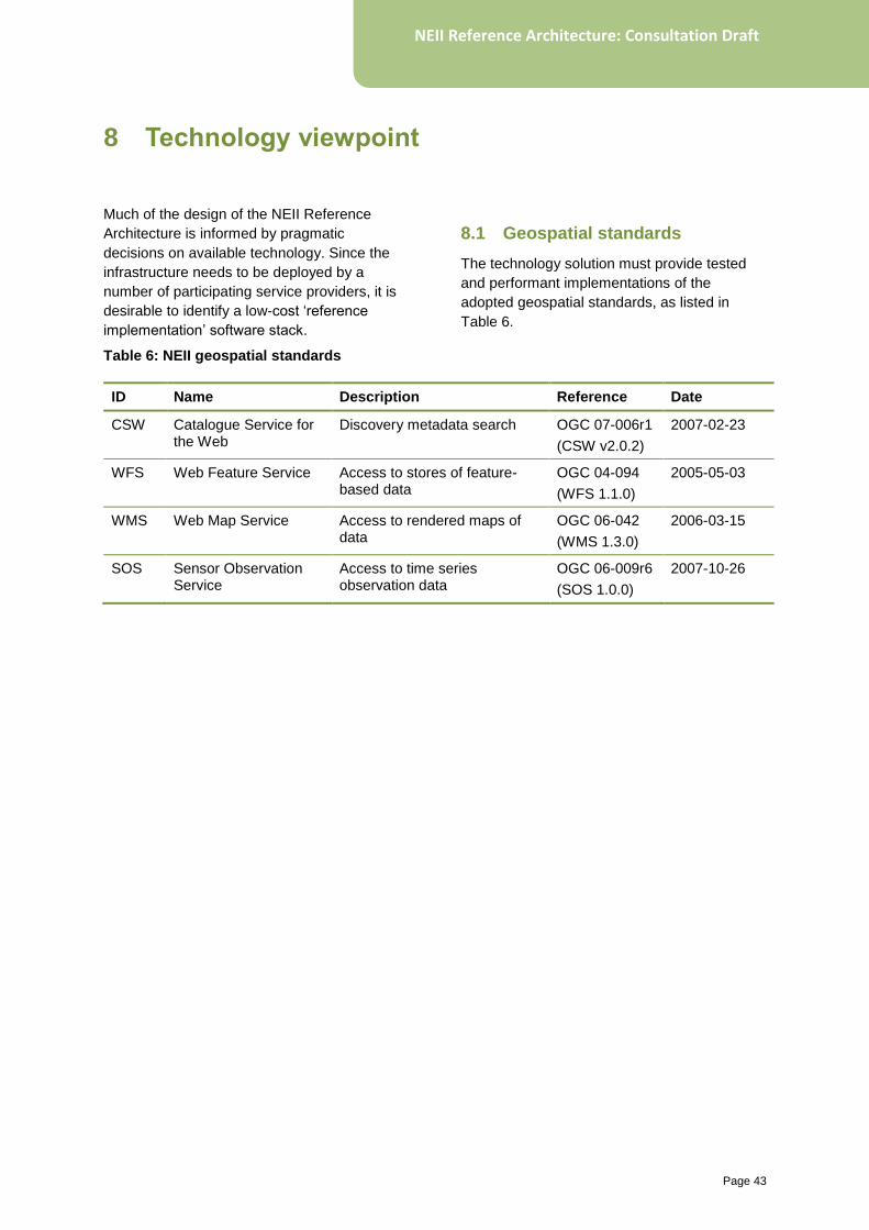
Page 43
NEII Reference Architecture: Consultation Draft
Much of the design of the NEII Reference
Architecture is informed by pragmatic
decisions on available technology. Since the
infrastructure needs to be deployed by a
number of participating service providers, it is
desirable to identify a low-cost ‘reference
implementation’ software stack.
8.1 Geospatial standards
The technology solution must provide tested
and performant implementations of the
adopted geospatial standards, as listed in
Table 6.
Table 6: NEII geospatial standards
ID Name Description Reference Date
CSW Catalogue Service for the Web
Discovery metadata search OGC 07-006r1
(CSW v2.0.2)
2007-02-23
WFS Web Feature Service Access to stores of feature-based data
OGC 04-094
(WFS 1.1.0)
2005-05-03
WMS Web Map Service Access to rendered maps of data
OGC 06-042
(WMS 1.3.0)
2006-03-15
SOS Sensor Observation Service
Access to time series observation data
OGC 06-009r6
(SOS 1.0.0)
2007-10-26
8 Technology viewpoint
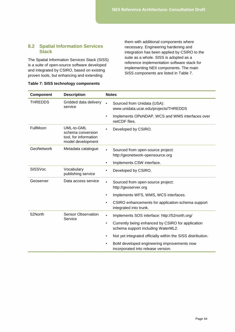
Page 44
NEII Reference Architecture: Consultation Draft
8.2 Spatial Information Services Stack
The Spatial Information Services Stack (SISS)
is a suite of open-source software developed
and integrated by CSIRO, based on existing
proven tools, but enhancing and extending
them with additional components where
necessary. Engineering hardening and
integration has been applied by CSIRO to the
suite as a whole. SISS is adopted as a
reference implementation software stack for
implementing NEII components. The main
SISS components are listed in Table 7.
Table 7: SISS technology components
Component Description Notes
THREDDS Gridded data delivery service
• Sourced from Unidata (USA):
www.unidata.ucar.edu/projects/THREDDS
• Implements OPeNDAP, WCS and WMS interfaces over
netCDF files.
FullMoon UML-to-GML schema conversion tool, for information model development
• Developed by CSIRO.
GeoNetwork Metadata catalogue • Sourced from open-source project:
http://geonetwork-opensource.org
• Implements CSW interface.
SISSVoc Vocabulary publishing service
• Developed by CSIRO.
Geoserver Data access service • Sourced from open-source project:
http://geoserver.org
• Implements WFS, WMS, WCS interfaces.
• CSIRO enhancements for application-schema support
integrated into trunk.
52North Sensor Observation Service
• Implements SOS interface: http://52north.org/
• Currently being enhanced by CSIRO for application
schema support including WaterML2.
• Not yet integrated officially within the SISS distribution.
• BoM developed engineering improvements now
incorporated into release version.
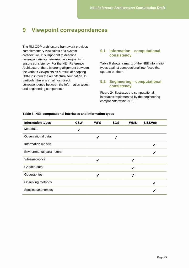
Page 45
NEII Reference Architecture: Consultation Draft
The RM-ODP architecture framework provides
complementary viewpoints of a system
architecture. It is important to describe
correspondences between the viewpoints to
ensure consistency. For the NEII Reference
Architecture, there is strong alignment between
the various viewpoints as a result of adopting
O&M to inform the architectural foundation. In
particular there is an almost direct
correspondence between the information types
and engineering components.
9.1 Information—computational consistency
Table 8 shows a matrix of the NEII information
types against computational interfaces that
operate on them.
9.2 Engineering—computational consistency
Figure 24 illustrates the computational
interfaces implemented by the engineering
components within NEII.
Table 8: NEII computational interfaces and information types
Information types CSW WFS SOS WMS SISSVoc
Metadata ✔
Observational data ✔ ✔
Information models ✔
Environmental parameters ✔
Sites/networks ✔ ✔
Gridded data ✔
Geographies ✔ ✔
Observing methods ✔
Species taxonomies ✔
9 Viewpoint correspondences
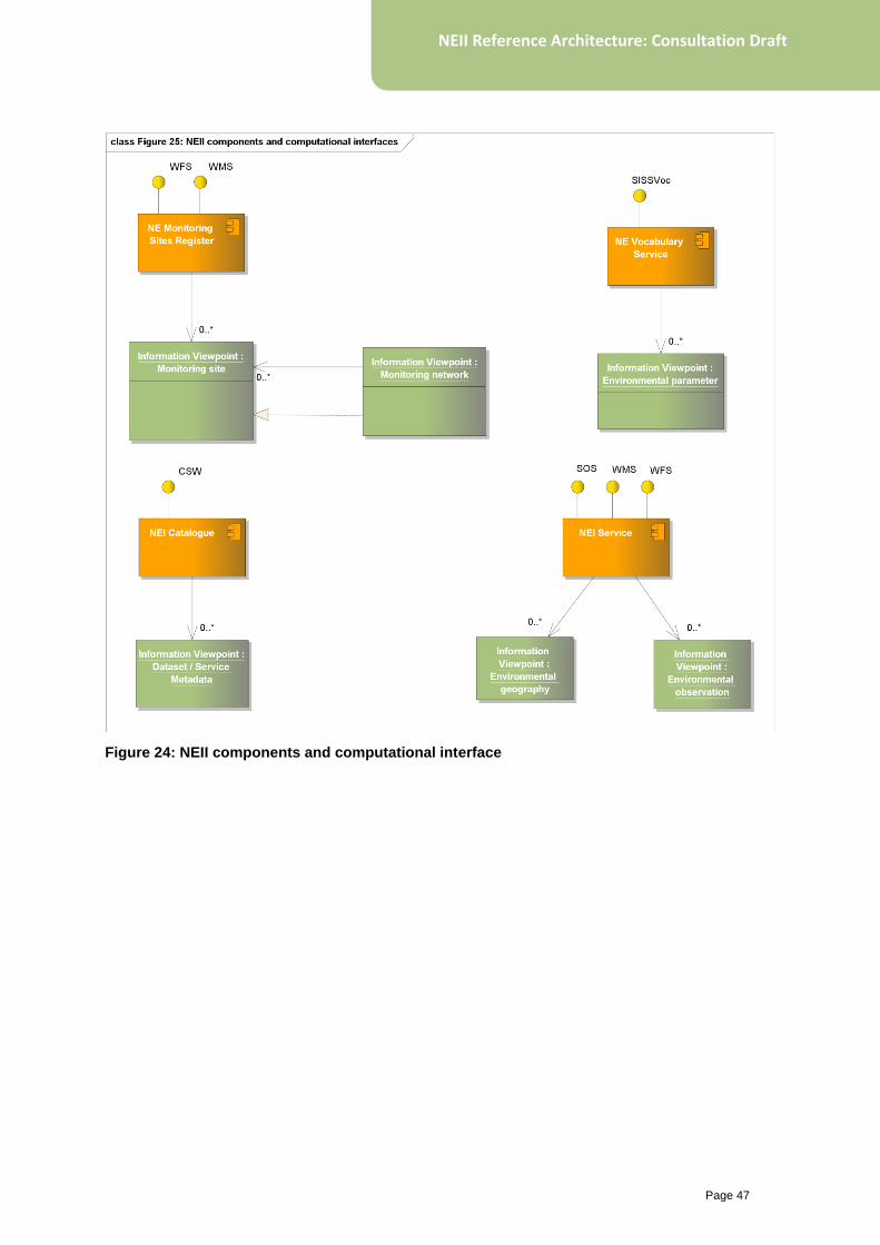
Page 47
NEII Reference Architecture: Consultation Draft
Figure 24: NEII components and computational interface
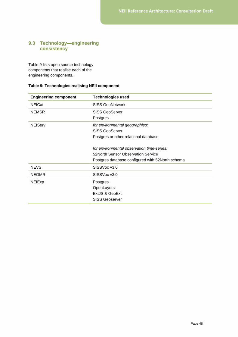
Page 48
NEII Reference Architecture: Consultation Draft
9.3 Technology—engineering consistency
Table 9 lists open source technology
components that realise each of the
engineering components.
Table 9: Technologies realising NEII component
Engineering component Technologies used
NEICat SISS GeoNetwork
NEMSR SISS GeoServer
Postgres
NEIServ for environmental geographies:
SISS GeoServer
Postgres or other relational database
for environmental observation time-series:
52North Sensor Observation Service
Postgres database configured with 52North schema
NEVS SISSVoc v3.0
NEOMR SISSVoc v3.0
NEIExp Postgres
OpenLayers
ExtJS & GeoExt
SISS Geoserver

www.bom.gov.au/environment