Embed Size (px)
Citation preview
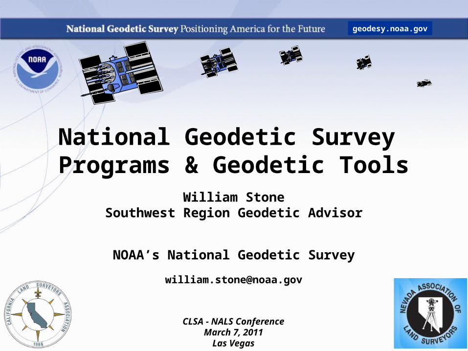
National Geodetic Survey Programs & Geodetic Tools
William StoneSouthwest Region Geodetic Advisor
NOAA’s National Geodetic Survey
CLSA - NALS ConferenceMarch 7, 2011
Las Vegas
geodesy.noaa.gov
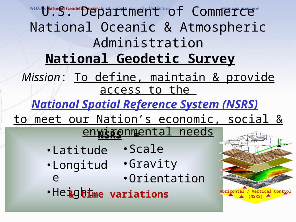
• Latitude• Longitude• Height
• Scale• Gravity• Orientation
U.S. Department of CommerceNational Oceanic & Atmospheric Administration
National Geodetic Survey
Mission: To define, maintain & provide access to the National Spatial Reference System (NSRS)
to meet our Nation’s economic, social & environmental needs
NSRS =
& time variations Horizontal / Vertical Control(NSRS)
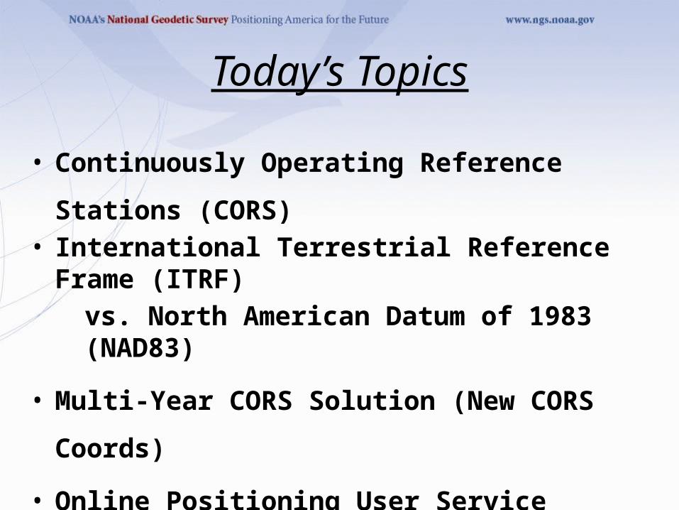
Today’s Topics
• Continuously Operating Reference Stations (CORS)• International Terrestrial Reference Frame (ITRF)
vs. North American Datum of 1983 (NAD83)
• Multi-Year CORS Solution (New CORS Coords)
• Online Positioning User Service (OPUS)
• NGS Ten-Year Plan (New Datums)
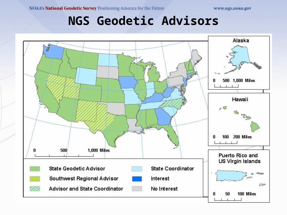
NGS Geodetic Advisors
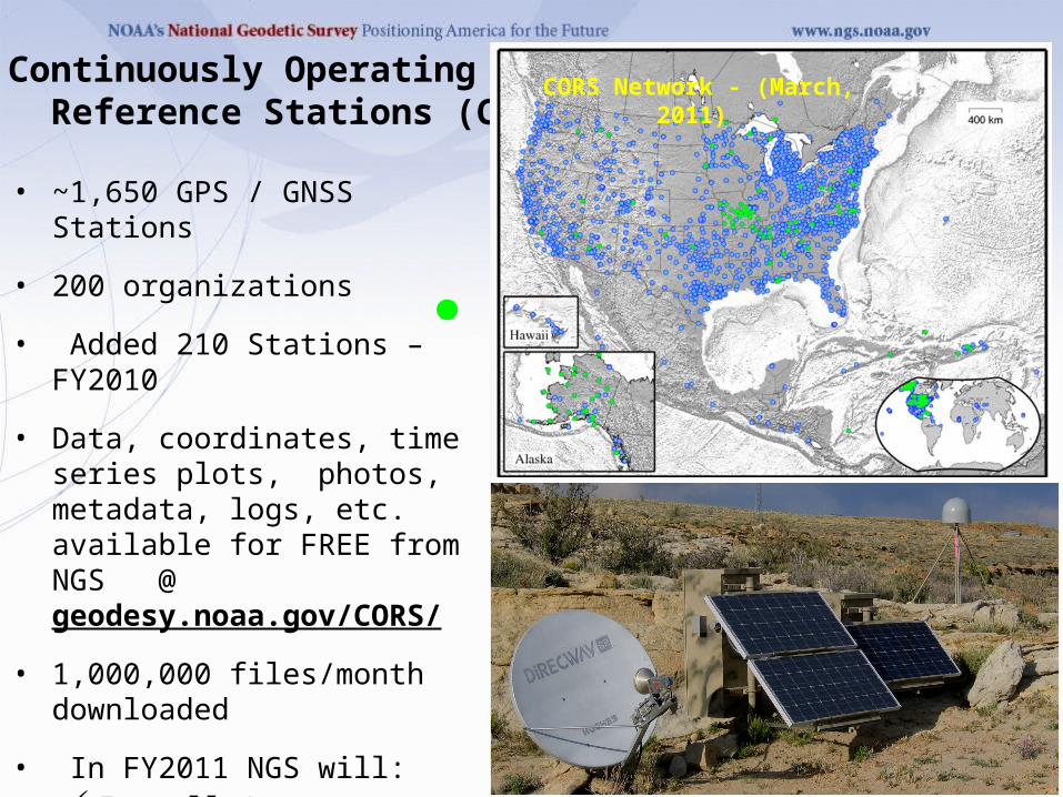
Continuously Operating Reference Stations (CORS)
• ~1,650 GPS / GNSS Stations
• 200 organizations
• Added 210 Stations – FY2010
• Data, coordinates, time series plots, photos, metadata, logs, etc. available for FREE from
NGS @ geodesy.noaa.gov/CORS/
• 1,000,000 files/month downloaded
• In FY2011 NGS will: Install 1 “Foundation” CORS to
support ITRF connection & improvement
Install 3 CORS co-located with tide/water level stations
CORS Network - (March, 2011)
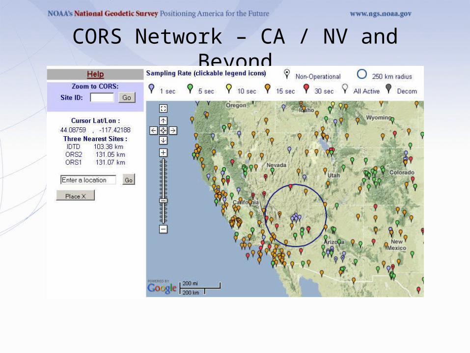
CORS Network – CA / NV and Beyond
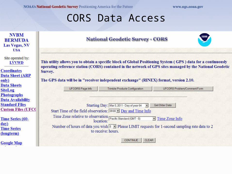
CORS Data Access
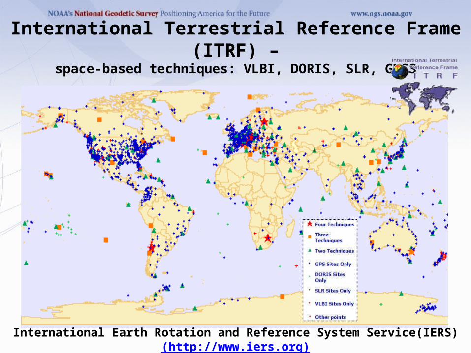
International Terrestrial Reference Frame (ITRF) –space-based techniques: VLBI, DORIS, SLR, GNSS
Current version: ITRF2008 (epoch 2005.0)
International Earth Rotation and Reference System Service(IERS)(http://www.iers.org)
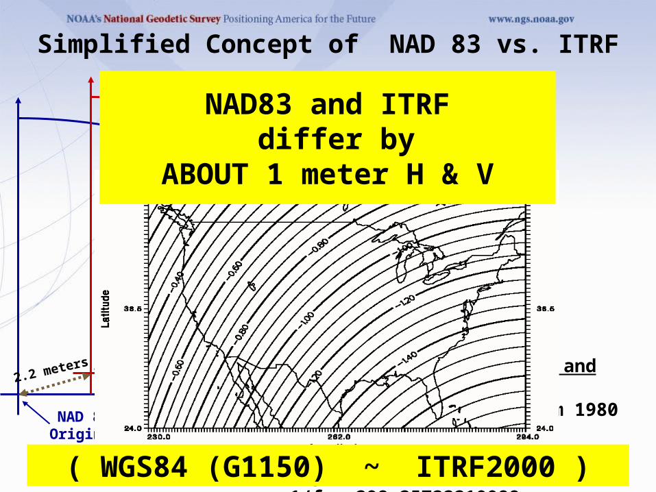
2.2 meters
NAD 83Origin
ITRF 00Origin
Earth’s
Surface
hNAD83 hITRF
Ellipsoid for both NAD83 and ITRF: Geodetic Reference System 1980 (GRS80)a = 6,378,137.000 meters (semi-major axis)1/f = 298.25722210088 (flattening)
Simplified Concept of NAD 83 vs. ITRF
NAD83 and ITRF differ by
ABOUT 1 meter H & V
( WGS84 (G1150) ~ ITRF2000 )
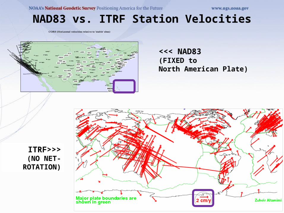
<<< NAD83 (FIXED to North American Plate)
ITRF>>>(NO NET-
ROTATION)
NAD83 vs. ITRF Station Velocities
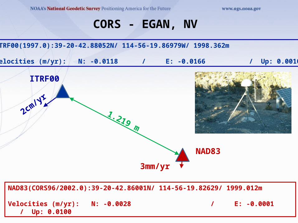
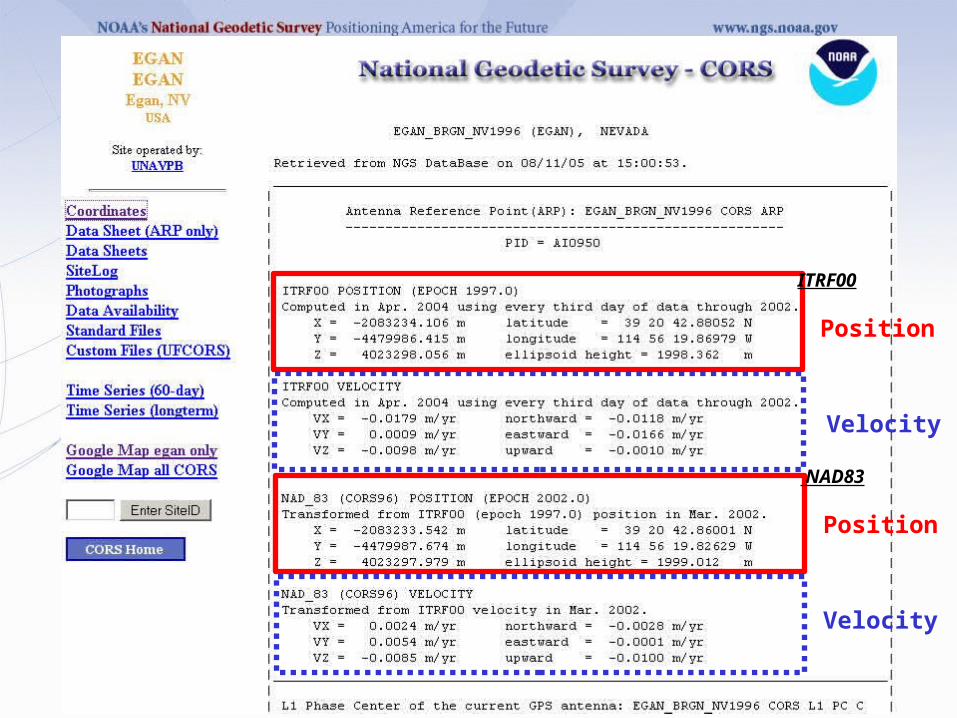
CORS - EGAN, NV
ITRF00(1997.0):39-20-42.88052N/ 114-56-19.86979W/ 1998.362m
Velocities (m/yr): N: -0.0118 / E: -0.0166 / Up: 0.0010
NAD83(CORS96/2002.0):39-20-42.86001N/ 114-56-19.82629/ 1999.012m
Velocities (m/yr): N: -0.0028 / E: -0.0001 / Up: 0.0100
ITRF00
NAD83
1.219 m
2cm/y
r
3mm/yr
ITRF00
Position
Velocity
NAD83
Position
Velocity
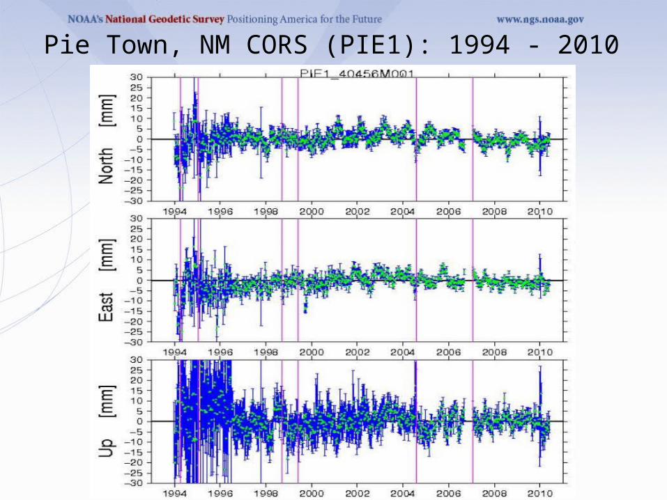
Pie Town, NM CORS (PIE1): 1994 - 2010
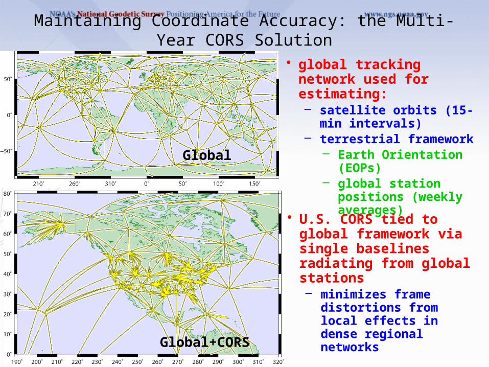
Maintaining Coordinate Accuracy: the Multi-Year CORS Solution
Global
Global+CORS
• global tracking network used for estimating:– satellite orbits (15-min intervals)– terrestrial framework
– Earth Orientation (EOPs)– global station positions
(weekly averages)
• U.S. CORS tied to global framework via single baselines radiating from global stations– minimizes frame distortions
from local effects in dense regional networks
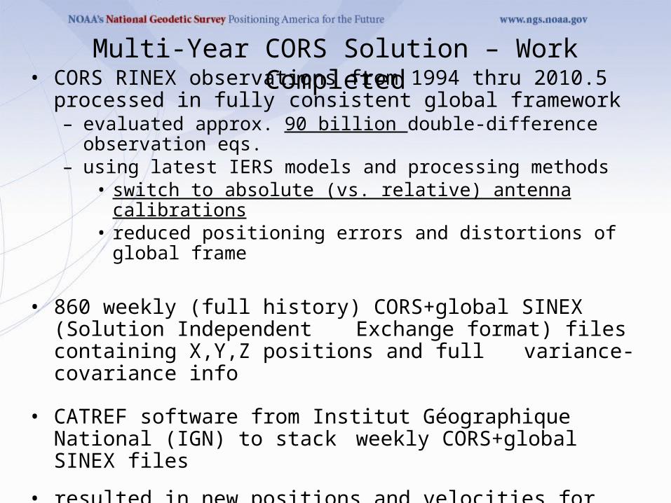
• CORS RINEX observations from 1994 thru 2010.5 processed in fully consistent global framework
– evaluated approx. 90 billion double-difference observation eqs.– using latest IERS models and processing methods
• switch to absolute (vs. relative) antenna calibrations• reduced positioning errors and distortions of global frame
• 860 weekly (full history) CORS+global SINEX (Solution Independent Exchange format) files containing X,Y,Z positions and full variance-covariance info
• CATREF software from Institut Géographique National (IGN) to stack weekly CORS+global SINEX files
• resulted in new positions and velocities for CORS• 4,906 position / velocity estimates for 2,264 CORS+global stations• solution aligned to ITRF2008 with negligible distortions of frame• calibrated for use with pending igs08.atx antenna phase center
variation (PCV) models
Multi-Year CORS Solution – Work Completed
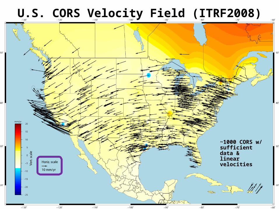
U.S. CORS Velocity Field (ITRF2008)
~1000 CORS w/ sufficient data & linear velocities
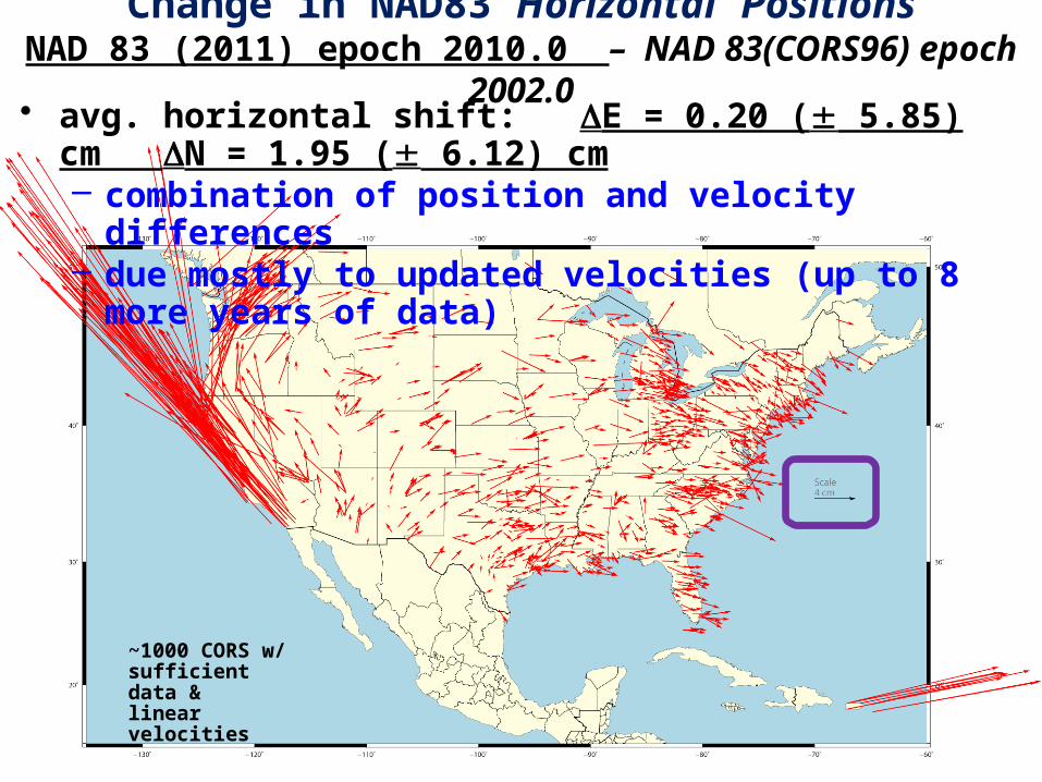
Change in NAD83 Horizontal PositionsNAD 83 (2011) epoch 2010.0 – NAD 83(CORS96) epoch 2002.0
• avg. horizontal shift: E = 0.20 ( 5.85) cm N = 1.95 ( 6.12) cm– combination of position and velocity differences– due mostly to updated velocities (up to 8 more years of data)
~1000 CORS w/ sufficient data & linear velocities
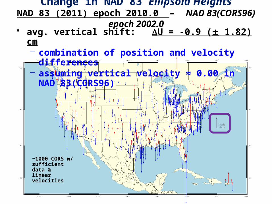
Change in NAD 83 Ellipsoid HeightsNAD 83 (2011) epoch 2010.0 – NAD 83(CORS96) epoch 2002.0• avg. vertical shift: U = -0.9 ( 1.82) cm
– combination of position and velocity differences– assuming vertical velocity ≈ 0.00 in NAD 83(CORS96)
~1000 CORS w/ sufficient data & linear velocities
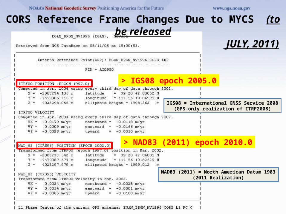
> NAD83 (2011) epoch 2010.0
> IGS08 epoch 2005.0
CORS Reference Frame Changes Due to MYCS (to be released JULY, 2011)
IGS08 = International GNSS Service 2008(GPS-only realization of ITRF2008)
NAD83 (2011) = North American Datum 1983(2011 Realization)
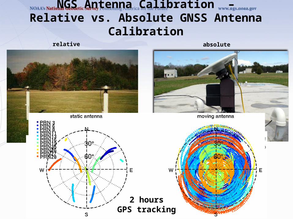
NGS Antenna Calibration –Relative vs. Absolute GNSS Antenna Calibration
relative absolute
2 hoursGPS tracking
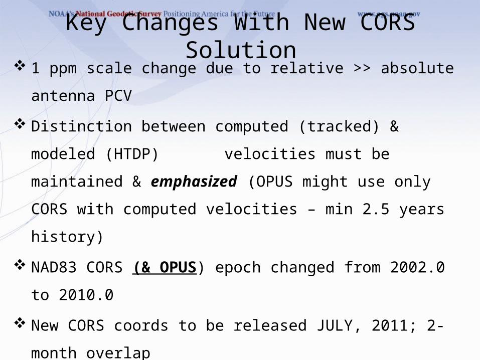
Key Changes With New CORS Solution 1 ppm scale change due to relative >> absolute antenna PCV
Distinction between computed (tracked) & modeled (HTDP)
velocities must be maintained & emphasized (OPUS might
use only CORS with computed velocities – min 2.5 years
history)
NAD83 CORS (& OPUS) epoch changed from 2002.0 to 2010.0
New CORS coords to be released JULY, 2011; 2-month overlap
Likely readjustment of passive control & new hybrid geoid model
NO transformation model from old to new CORS coordinates
WEBINAR – Tomorrow (March 8) at 10:00 am PST
(details in CORS Newsletter; available for post-viewing)
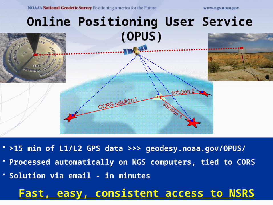
• >15 min of L1/L2 GPS data >>> geodesy.noaa.gov/OPUS/
• Processed automatically on NGS computers, tied to CORS
• Solution via email - in minutes
Fast, easy, consistent access to NSRS
Online Positioning User Service (OPUS)
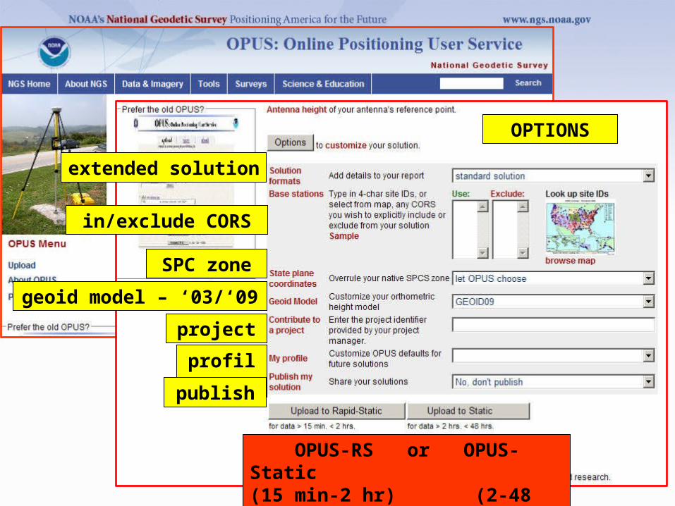
GPS file
antenna
antenna height
OPTIONS
in/exclude CORS
extended solution
SPC zone
geoid model – ‘03/‘09
project
profile
publish
OPUS-RS or OPUS-Static(15 min-2 hr) (2-48 hr)
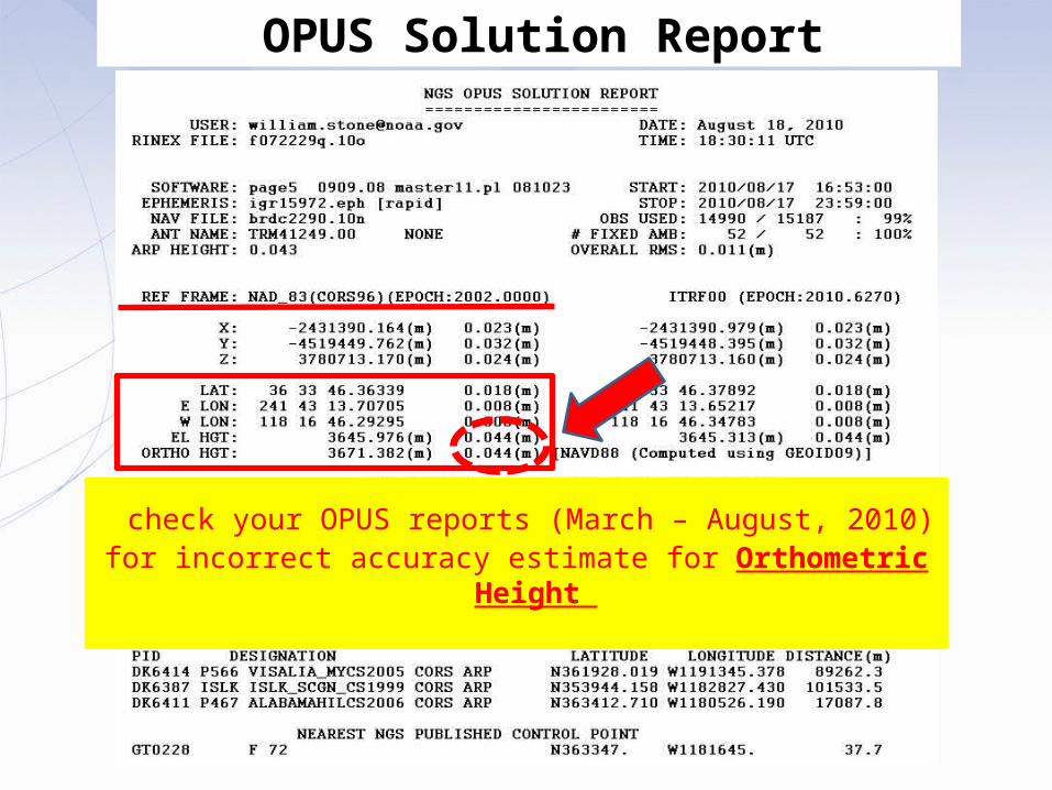
OPUS Solution Report
check your OPUS reports (March – August, 2010)for incorrect accuracy estimate for Orthometric Height
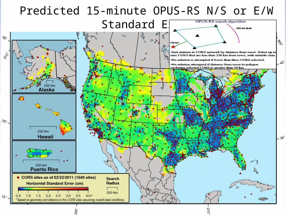
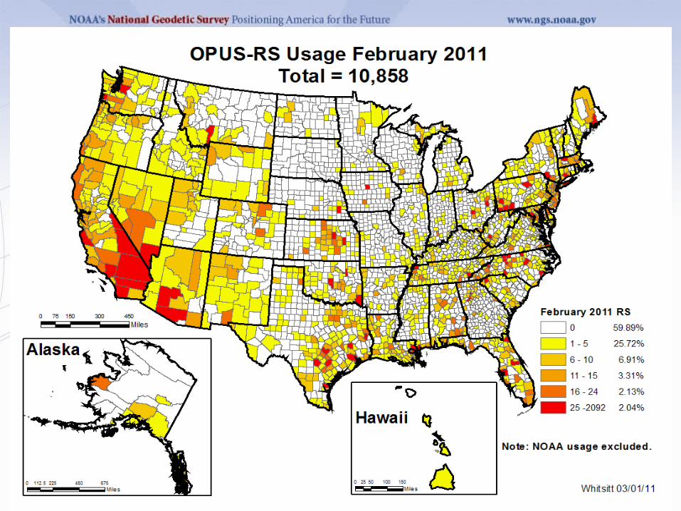
Predicted 15-minute OPUS-RS N/S or E/W Standard Error
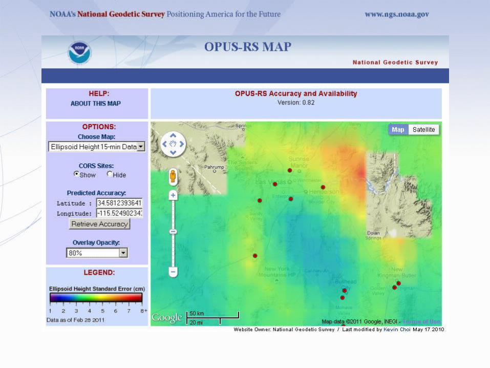
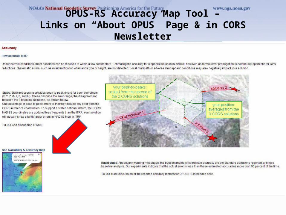
OPUS-RS Accuracy Map Tool –Links on “About OPUS” Page & in CORS Newsletter
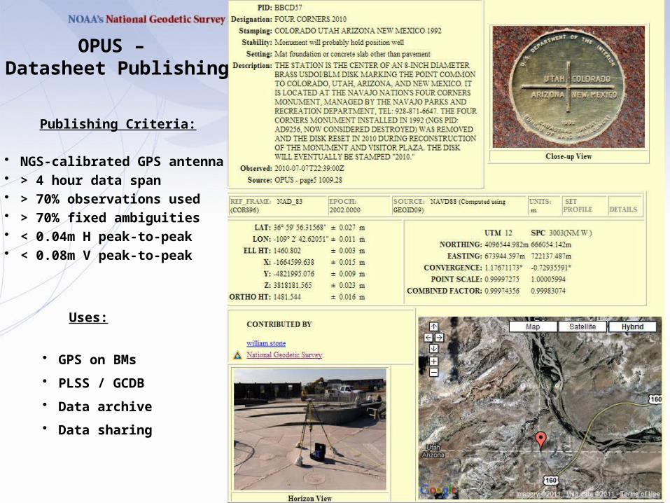
OPUS – Datasheet Publishing
Publishing Criteria:
• NGS-calibrated GPS antenna • > 4 hour data span • > 70% observations used • > 70% fixed ambiguities • < 0.04m H peak-to-peak • < 0.08m V peak-to-peak
Uses:
• GPS on BMs
• PLSS / GCDB
• Data archive
• Data sharing
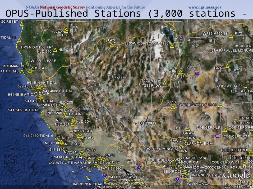
OPUS-Published Stations (3,000 stations - Feb., 2011)
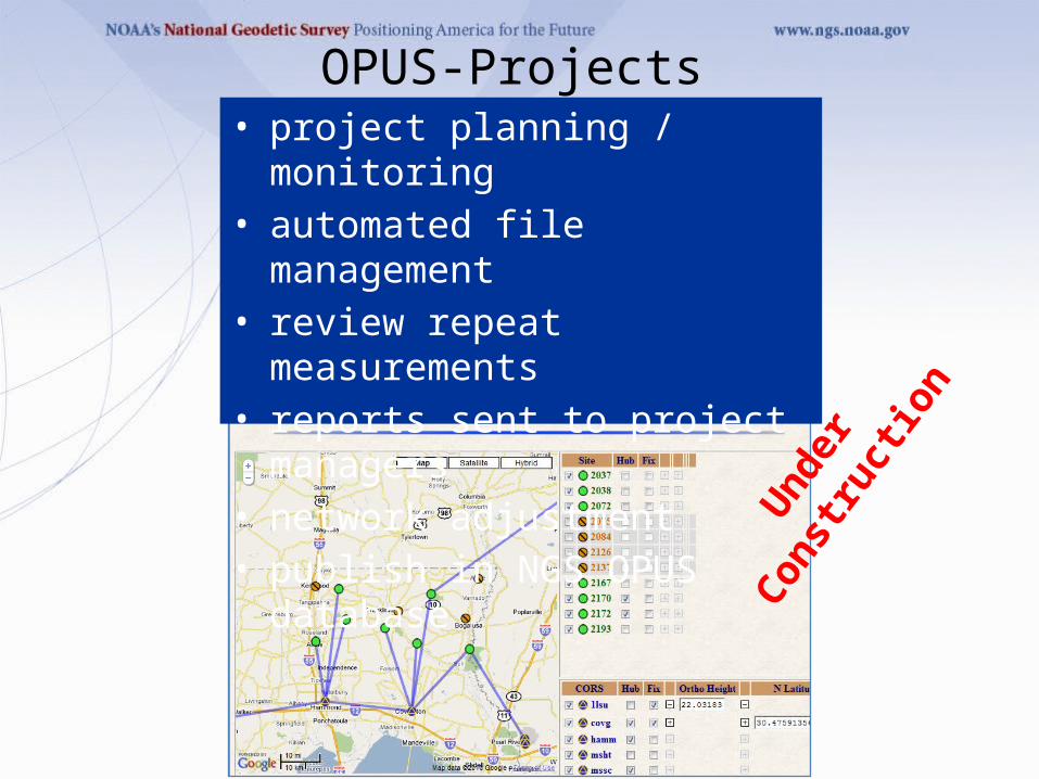
• project planning / monitoring• automated file management• review repeat measurements• reports sent to project managers• network adjustment • publish in NGS OPUS database
OPUS-Projects
Und
er
Cons
truc
tion
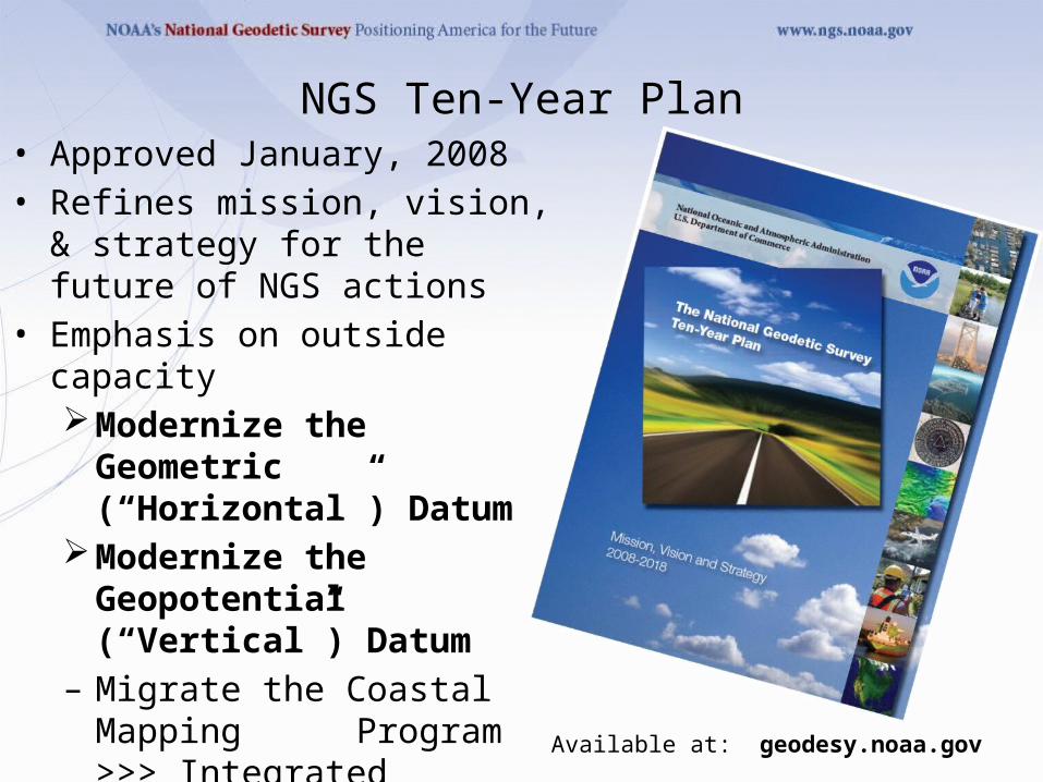
NGS Ten-Year Plan• Approved January, 2008• Refines mission, vision, & strategy
for the future of NGS actions • Emphasis on outside capacity
Modernize the Geometric (“Horizontal”) Datum
Modernize the Geopotential (“Vertical”) Datum
– Migrate the Coastal Mapping Program >>> Integrated Ocean & Coastal
Mapping– Evolve Core Capabilities– Increase Agency Visibility Available at: geodesy.noaa.gov
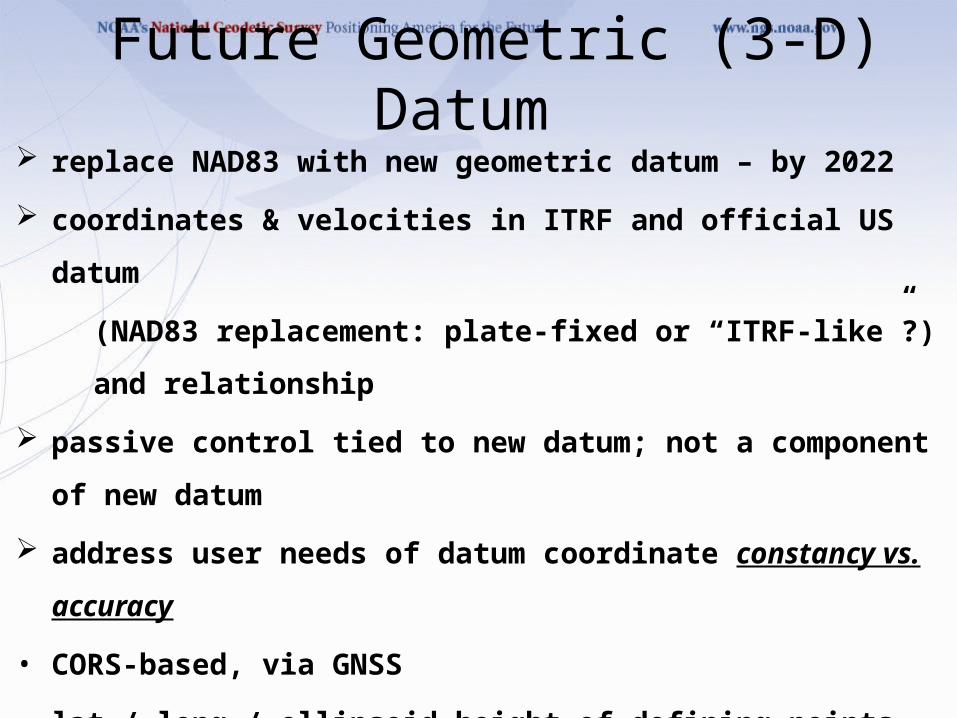
Future Geometric (3-D) Datum replace NAD83 with new geometric datum – by 2022
coordinates & velocities in ITRF and official US datum
(NAD83 replacement: plate-fixed or “ITRF-like”?) and relationship
passive control tied to new datum; not a component of new datum
address user needs of datum coordinate constancy vs. accuracy
• CORS-based, via GNSS
• lat / long / ellipsoid height of defining points accurate to 1 mm, anytime
• CORS coordinates computed / published daily; track changes
• support development of real-time networks
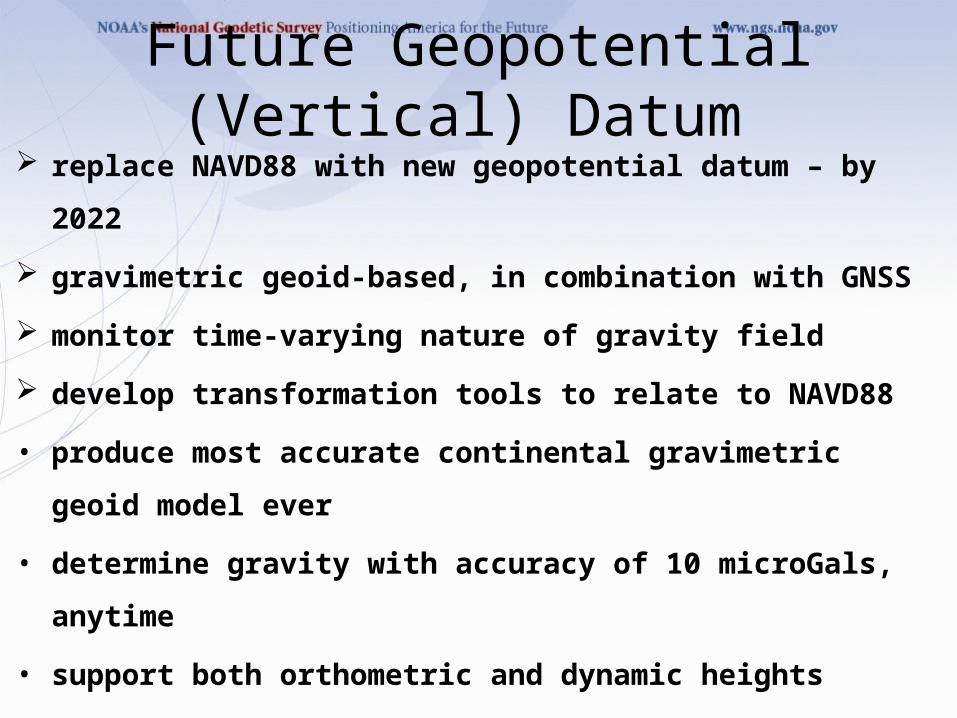
Future Geopotential (Vertical) Datum replace NAVD88 with new geopotential datum – by 2022
gravimetric geoid-based, in combination with GNSS
monitor time-varying nature of gravity field
develop transformation tools to relate to NAVD88
• produce most accurate continental gravimetric geoid model ever
• determine gravity with accuracy of 10 microGals, anytime
• support both orthometric and dynamic heights
• Height Modernization is fully supported
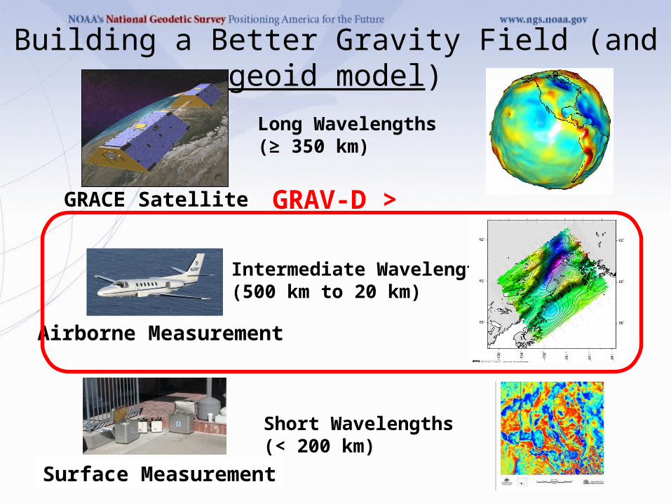
Building a Better Gravity Field (and geoid model)
Long Wavelengths(≥ 350 km)
GRACE Satellite
Intermediate Wavelengths(500 km to 20 km)
Airborne Measurement
Surface Measurement
Short Wavelengths(< 200 km)
GRAV-D >
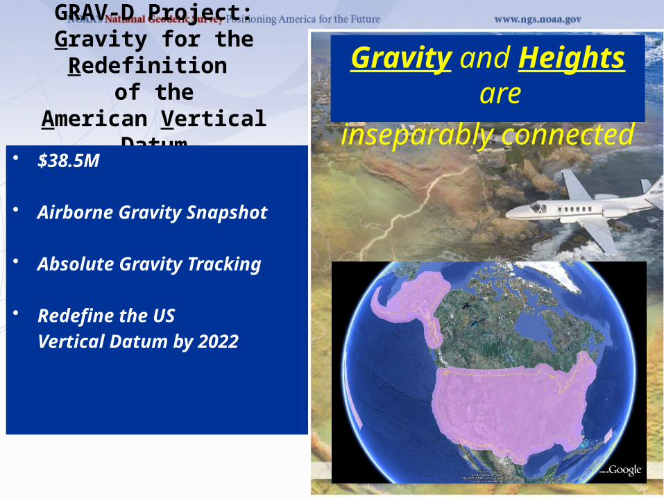
GRAV-D Project:Gravity for the Redefinition
of theAmerican Vertical Datum
• $38.5M
• Airborne Gravity Snapshot
• Absolute Gravity Tracking
• Redefine the USVertical Datum by 2022
Gravity and Heights are
inseparably connected
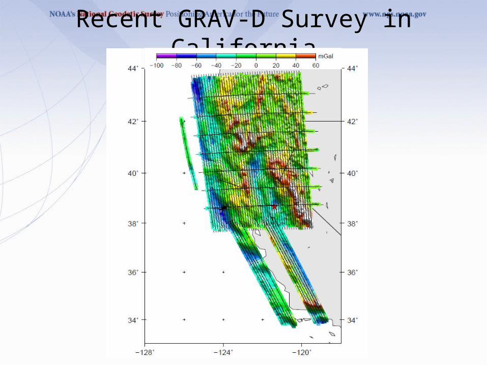
Recent GRAV-D Survey in California
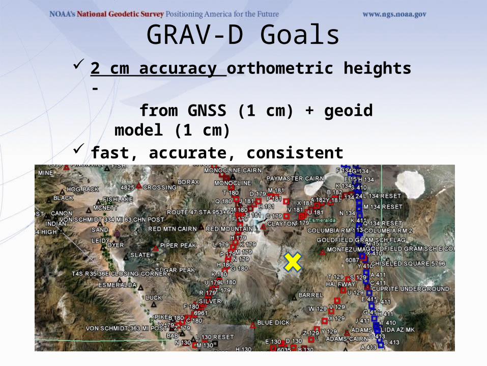
2 cm accuracy orthometric heights -
from GNSS (1 cm) + geoid model (1 cm)
fast, accurate, consistent orthometric heights -
everywhere in the USA
GRAV-D Goals
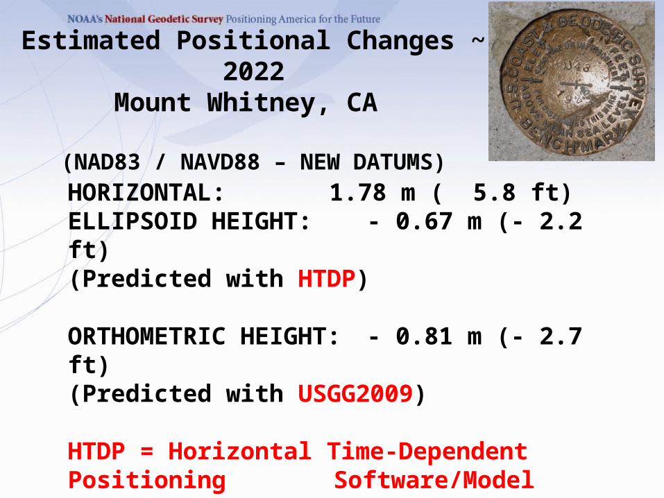
Estimated Positional Changes ~ 2022Mount Whitney, CA
(NAD83 / NAVD88 – NEW DATUMS)
HORIZONTAL: 1.78 m ( 5.8 ft)ELLIPSOID HEIGHT: - 0.67 m (- 2.2 ft)(Predicted with HTDP)
ORTHOMETRIC HEIGHT: - 0.81 m (- 2.7 ft)(Predicted with USGG2009)
HTDP = Horizontal Time-Dependent Positioning Software/Model
USGG2009 = US Gravimetric Geoid 2009
![CORS Program FY0945]09... · 2009-10-01 · CORS Program FY09 Giovanni Sella CORS Program Manager NOAA- National Geodetic Survey giovanni.sella @ noaa.gov CGSIC Savannah, GA CORS](https://img.pdfslide.net/doc/110x75/5f09f82f7e708231d4296126/cors-program-4509-2009-10-01-cors-program-fy09-giovanni-sella-cors-program.jpg)