Embed Size (px)
Citation preview

National Geographic Information
System (NGIS) in Korea
: from a national policy point of view
Jongnam Choi
Western Illinois University
Geospatial Information Research Center
Korea Research Institute for Human Settlements

Panama vs. Korea History
International politics
Economic situation

Background
GIS was first introduced in the late 1980’s.
Multiple GIS projects were conducted by separate institutions.
duplicated data implementation, lack of compatibility, and
quality deterioration
The central government realized the necessity for GIS.
Facing a range of problems
- pollution, traffic jams, and a lack of basic infrastructure
- promote economic development
Two LNG explosions in 1994 and 1995
decisive moments for the introduction of the NGIS

Purpose
Korean government planned to establish the National Spatial
Data Infrastructure (NSDI) through various efforts
- to construct GIS framework data
- to set up NGIS standards
- to develop GIS technology
- to construct GIS education and distribution network
Three 5-year “NGIS Master Plan” established
but actively executed the NGIS projects from “1998”.
Economic Crisis in Korea

NGIS Master Plans
The 1st NGIS Master Plan (1995-2000)
- to construct the infrastructure for national spatial data
- to strengthen national competitiveness
- to improve administrative productivity
The 2nd NGIS Master Plan (2001-2005)
- to realize a digital national territory by expanding NSDI
The 3rd NGIS Master Plan (2006-2010)
- to create infrastructure for realization of ubiquitous country
Information
Super Highway

• Due to insufficient capability of the private sector, the
government sector led investments and policy
measures.
• Focused on creating the initial demand for GIS by
constructing some digital basic maps like topographic maps
• Foundations of GIS such as the standard, technology,
human resource, and R&D were provided.
1st NGIS Master Plan (1995-2000):
To construct the infrastructure for national spatial data
Building Foundation for GIS

The 1st NGIS Project
1. converting existing paper topographic maps into digital maps
- 1:5,000 and 1:25,000 digital maps covering the entire nation
- 1:1,000 digital maps covering the urban regions
2. digitizing cadastral maps, underground facilities maps, and
road network maps
(PBLIS : Parcel Based Land Information System)
Aerial
Photo
Drawing Field
Survey
Editing Digital Map

The 1st NGIS Project
1. GIS standardization for NGIS
Examples:
- Spatial Data Exchange Format for NGIS
- Standards for the national base map and thematic map
2. Establishment of the Act on NGIS (2000)
- Prevents duplication of similar projects and facilitates
coordination among them
- Preparation of guidelines for data security, data quality, and
so on

• Induce participations of the local governments and
private sectors
• Explore a plan to improve the productivity of administration
and the quality of life by developing application services
using spatial information to peoples
• Consolidate the spatial data distribution system
• Diversify the ways to train specialized human resources
with GIS education and research projects
2nd NGIS Master Plan (2001-2005)
To realize a digital national territory by NSDI
Utilization & Distribution of NGIS

Korea Land Information System (KLIS)
Goal
-online real time service for land information at a parcel level
-support for land policy decision making, real-estate trade
management, real-estate brokerage management and real-
estate taxation
DB implementations
- build digital topographic map
-build a consolidated zoning DB defining laws and regulations
(urban planning etc.) on a continuous cadastral map
The 2nd NGIS Project

<Main Website> <Search by address> <Browsing Information>
Information Service through KLIS
http://www.onnara.moct.go.kr

The 2nd NGIS Project
National Geographic Information Clearinghouse (NGIC)
- Online Service of the constructed geographic information
- NGIC provides the search and distribution services of
geographic information, constructed and gathered from the
public and private sides as an integrated GIS portal site
http://www.ngic.go.kr

Comparing Investment for the 1st and 2nd NGIS Projects
Unit : billion won
million dollar
116.6
20.4
1.4
0
278.7TOTAL
545.9
Framework Data
Standardization
GIS Application System
GIS Tech. Development
Clearinghouse
H&R Training
R&D
179.4
128.7 306.5
4.0
22.7
21.2
7.6 7.2
4.0 4.7

3rd NGIS Master Plan (2006-2010)
To create infrastructure for realization of ubiquitous country
Informatisation of the national territory
To strengthen the NSDI
Embodiment of
e-government
based on GIS
Improvement of
quality of life through GIS
Creating new businesses
using GIS
Vision
Objectives
Infrastructure for ubiquitous Korea
Maximize the practical
merit of NGIS
Construct NSDI for user’s demandCooperative promotion with
other information strategies
Promotion
Strategy

Organization for 3rd NGIS
NGIS Promotion Subcommittee
Civil Advisory Committee
Technology
Development
Subcommittee
Technical Support Agency
Standardization
Subcommittee
Utilization &
Distribution
Subcommittee
Fundamental
Geographic
Information
Subcommittee
Policy System
Subcommittee
NGIS Promotion Committee
Technology Development Subcommittee
Technology & Policy Support Agency
Standardization Subcommittee
Utilization & Distribution
Subcommittee
Framework data
Subcommittee
Policy System Subcommittee
NGIS Promotion Executive Committee
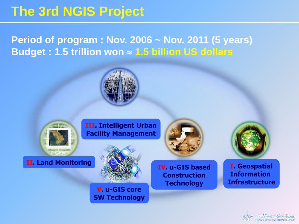
I. GeospatialInformation
Infrastructure
II. Land MonitoringIV. u-GIS based
Construction Technology
V. u-GIS coreSW Technology
III. Intelligent UrbanFacility Management
Period of program : Nov. 2006 ~ Nov. 2011 (5 years)
Budget : 1.5 trillion won 1.5 billion US dollars
The 3rd NGIS Project

NGIS Master Plans
Korea has successfully implemented the NGIS Plans
by encompassing public, civil and industrial sectors
Public institutions
- GIS-based e-government
- improve their administrative efficiency and public services
Civil sectors
- promotion of civil safety and convenience
Industrial sectors
- new industrial development and new business opportunity
- activate the service industry exploiting geospatial information

Competitiveness
Industrial,
Institutional,
Civil sectors
Research
Baseline development,
System development,
Standard building
Education
Develop human resources
training, workshops, educational
institutes

Thank you

Advanced geodetic
reference frameworks
Integration of surveying
Instruments and equipment
Geospatial DB construction
with Unique Feature Identifier
Improvement of efficiency in geo-spatial information manipulation
Budget reduction in land spatialization & mapping
Expense reduction in usual surveying
Increase of the operability of digital maps
Effects
R&D Project I -『 Geospatial Information Infrastructure 』
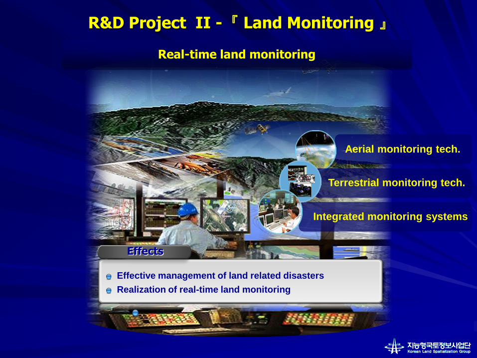
Aerial monitoring tech.
Integrated monitoring systems
Real-time land monitoring
Effective management of land related disasters
Realization of real-time land monitoring
R&D Project II -『 Land Monitoring 』
Terrestrial monitoring tech.
Effects

Underground Facility
Management
Ground Facility Management
Centralized Urban Facility
Management Platform
Acquisition of spatailization tech. & infra. for u-City implementation
Reduction of accidents in public facilities
Improvement of re-usability of spatial data
Future city infra. technologywith next generation facility management
R&D Project III -『 Intelligent Urban Facility Management 』
Effects

Integration of construction
CAD to GIS data
Resource and construction
site management with LBS
Geo-technical information
Management
Efficient management of construction resources
Real time update on the geo-morphological changesManagement of manpower, resources and facilitiesSafety in construction fields
R&D Project IV -『 u-GIS based Construction Technology 』
Effects
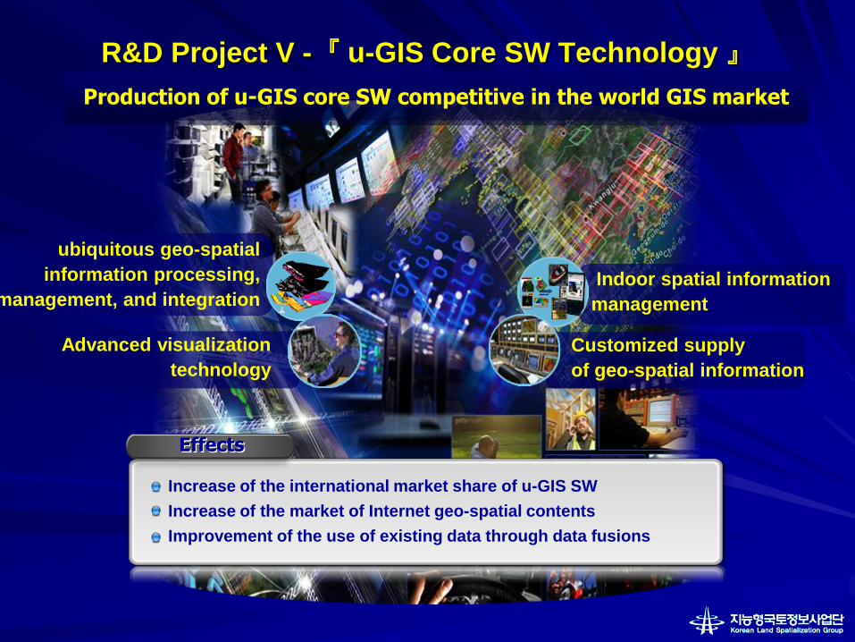
ubiquitous geo-spatial
information processing,
management, and integration
Advanced visualization
technology
Indoor spatial information
management
Production of u-GIS core SW competitive in the world GIS market
Increase of the international market share of u-GIS SW
Increase of the market of Internet geo-spatial contents
Improvement of the use of existing data through data fusions
Customized supply
of geo-spatial information
R&D Project V -『 u-GIS Core SW Technology 』
Effects

Construction of the 3D Spatial Data Infrastructure
- Construction of the 3D DB using various existing 2D database
- Ongoing Pilot project for the 3D data model and standards
<example of 3D spatial data>
Regions for the pilot project
Constructed Area (2006)
Pilot Area (2007)
The 3rd NGIS Project

The 3rd NGIS Project
Urban planning Flood simulation
Examples of 3D Application
Navigation