Embed Size (px)
Citation preview
- 1 -
NATIONAL OPEN UNIVERSITY OF NIGERIA
SCHOOL OF SCIENCE AND TECHNOLOGY
COURSE CODE: PHY 261
COURSE TITLE: GEOPHYSICS I
- 2 -
COURSE GUIDE
Course code PHY 261
Credit units 3
Course Title Geophysics I
Course Developer Dr. S. Olatunji
Department of Physics, Faculty of Science,
University of Ilorin, Ilorin, Nigeria
Course Editor
Programme leader
Course Coordinator

- 3 -
Introduction-------------------------------------------------------------------------------------------1
Requirement for this course-------------------------------------------------------------------------1
What you will learn in this course-----------------------------------------------------------------1
Course contents---------------------------------------------------------------------------------------2
Course Aims ------------------------------------------------------------------------------------------2
Course Objectives------------------------------------------------------------------------------------2
Working through this course -----------------------------------------------------------------------3
The course materials --------------------------------------------------------------------------------3
Course Guides----------------------------------------------------------------------------------------4
Study Modules----------------------------------------------------------------------------------------4
Assessments ------------------------------------------------------------------------------------------6
Preparation for end of course Examination-------------------------------------------------------7
Facilitator-Student Interactions---------------------------------------------------------------------7
Conclusion--------------------------------------------------------------------------------------------8
- 4 -
Introduction
Geophysics 1 (PHY 261) is a 3 credit unit second semester course available to all
student offering Bachelor of Science (B.Sc.) Physics
Geophysics is a unit in physics department in which any one can specialise as an
area of research interest. It is an area where physics principles are employed to study the
earth in its entirety. That is, geophysics can be seen as an area where physics principles
are employed to explore the liquid, solid and gaseous part of the earth.
This course concerns with application of physics principles to studying the solid
earth.
Requirement for this Course
To adequately comprehend this course you will require sound knowledge of basic
principles in physics, at least up to the second year level at University. Sound footing in
mathematics is necessary to be able to comprehend the mathematical relations involved
in the treatment of this course; this is in addition to high commitment to learning. The
course must be handled by a trained applied geophysicist, with sound knowledge of
physics of the solid earth and geophysical methods such as Gravity and magnetic.
What you will learn in this Course
- 5 -
The course is treated under 21 units, sectioned into 4 modules. You are fully
informed on every subtopic for further readings peculiar to each unit are provided under
each unit. Guidance to solutions to the tutor-marked assignments is provided in the
assignment file name TMA solution. You are strongly advised to attend the regular
tutorial classes on the course. The course will provide you with information to face the
challenges in the area of introductory geophysics regarding geomagnetism, magnetic and
gravity methods.
Course contents
For proper understanding, this course is structured as followed:
The earth: internal structure and constitution, Density of rocks and ores. Geomagnetism:
Origin, properties of rocks. Gravity methods: Newton’s gravitation, Application,
instruments, Zero-length spring gravimeter, Field works, data processing and
interpretation. Magnetic methods: Definitions, concepts, instrument, fieldwork, data
processing and interpretation.
Course Aims
This course aimed at acquainting you with knowledge on meaning and sources of
geomagnetism, gravity and magnetic methods of geophysics prospecting.
Course Objectives
- 6 -
In order to achieve the aims of this course each unit has specific objectives to be
achieved at the expiration of studying every unit. Below are the comprehensive
objectives of this course you should be able to:
- Explain the theoretical background of gravity methods
- Describe the working principles of zero-length gravimeter
- Explain the gravity field procedure, data processing and interpretations.
- Describe density determination and variations within the solid earth
- Explain the origin and properties of geomagnetism
- Discuss the working principle of proton magnetometer
- Explain the magnetic field procedure, data processing and interpretations.
Working through this Course
To complete this course you will need to read every unit, related texts and other
materials which may be provided by the National Open University of Nigeria (NOUN).
Each unit contains self assessment exercise that will test your comprehension at
certain stages of the unit. You will be required to submit assignment for assessment
purposes. At the end of the course there will be a final examination.
The course will take about 17 weeks to complete. Below, you will find what to
do, how to do and suggested time allocations to each unit for successful completion of the
course. You will need to engage in a serious personal reading and to attend tutorial
sessions where you could validate some of your personal findings.
The course Materials
- 7 -
The main components of this course are:
(a) Course guide
(b) Study modules
(c) Assessments
(d) Presentation Schedule.
Course Guides
This presents you all-round in formations such as the course content, aim and
objectives, requirement for successful execution of the course including time
management assessment procedure etc. you are advised to read the course guide carefully
as it will serve as your road map into mastery of the course.
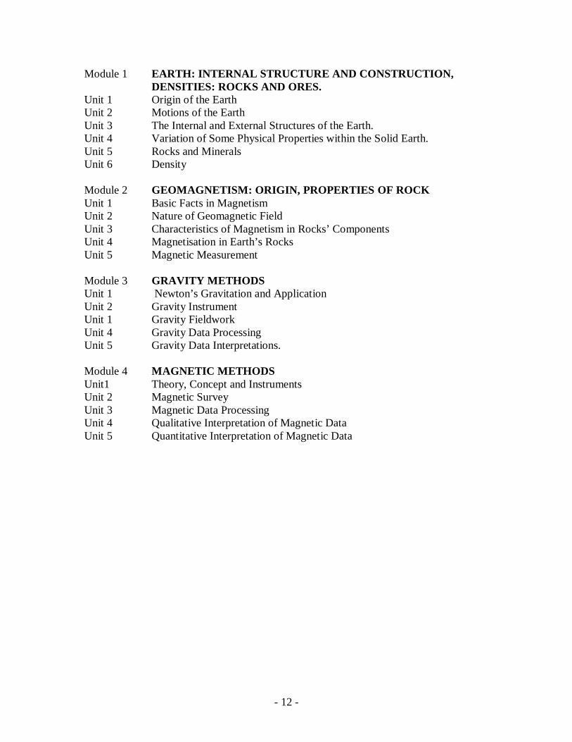
Study Modules
The content is sectioned into 4 modules. Each module contains series of units of
related concepts. The details of the modules are shown below:
Module 1 The earth: internal structure and construction: Density of Rocks and Ores.
Unit 1: Origin of the Earth
Unit 2: Motions of the earth
Unit 3: The internal and external structures of the earth.
Unit 4: Variation of some physical properties within the solid earth.
Unit 5: Rocks and Minerals
Unit 6: Density
- 8 -
Module 2 Geomagnetism: Origin, properties of rock
Unit 1: Basic facts in magnetism
Unit 2: Nature of Geomagnetic field
Unit 3: Characteristics of magnetism in rocks components
Unit 4: Magnetisation in earth’s rock
Unit 5: Magnetic Measurement
Module 3 Gravity Methods:
Unit 1: Newton’s gravitation and Application
Unit 2: Gravity Instrument
Unit 1: Gravity field work
Unit 4: Gravity Data Processing
Unit 5: Gravity Data interpretations.
Module 4 Magnetic methods
Unit1: Theory, concept and instruments
Unit 2: Magnetic Survey
Unit 3 Magnetic Data Processing
Unit 4: Qualitative Interpretation of Magnetic data
Unit 5: Quantitative interpretation of magnetic data
You should be able to exhaust about 2 units within a week in order to work ahead
of time. Each unit contains subtopics related to the main topic of the unit in question as
shown above. As main headings, each unit includes; introduction, objectives, subtopics,
- 9 -
reading materials, self-assessment exercises, conclusion, summary, Tutor marked
assignment and references and other resources.
Assessments
There are three main aspects for the assessments of the course.
(a) Self-assessment exercise: This is done by yourself on yourself to access your
progress and give directions for improvement in subsequent studies.
(b) Tutor marked assignment: This serves as a recapitulation on your understanding
of the unit which will concretise your understanding in a convincing way to the facilitator
in charge.
(c) Written Examination: This comes up once at the end of the course for the purpose
of quantification of your comprehension the whole course at a sitting.
You are strongly advised to attempt all the assessments. The works you submit to the
facilitator will count 30% marks and the end of course examination will stand for 70%
marks of the total score for the course
You are advised to always submit the tutor marked assignment to the facilitator as
scheduled. It must be noted that evidences of independent readings outside the written
course materials given attract much marks from the facilitator in the submitted
assignments.
- 10 -
You must note that course materials given have important dates for the timely
completion. Thus, prompt attendance of tutorials and timely submission of assignment
are imminent for the successful completion of the course. You should guide against
falling behind in your works.
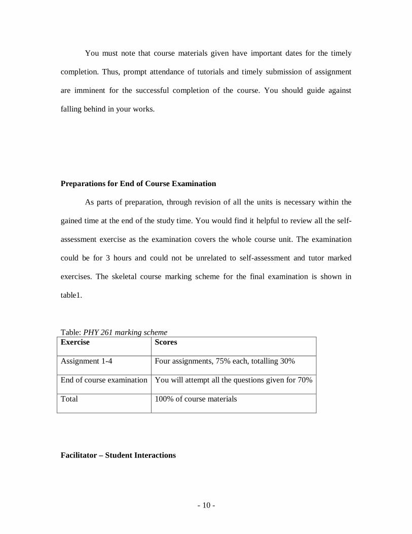
Preparations for End of Course Examination
As parts of preparation, through revision of all the units is necessary within the
gained time at the end of the study time. You would find it helpful to review all the self-
assessment exercise as the examination covers the whole course unit. The examination
could be for 3 hours and could not be unrelated to self-assessment and tutor marked
exercises. The skeletal course marking scheme for the final examination is shown in
table1.
Table: PHY 261 marking scheme Exercise Scores
Assignment 1-4 Four assignments, 75% each, totalling 30%
End of course examination You will attempt all the questions given for 70%
Total 100% of course materials
Facilitator – Student Interactions
- 11 -
You have 16 hours of tutorials with the facilitator. You will be notified informed
of the dates, times and location of tutorials as soon as you are allocated a tutorials group.
Your facilitator will always mark and comment on your submitted assignments. You are
expected to submit the assignments in time rather than on time. You are free to register
complaints, should you not contented with the markings of the assignments as soon as
possible preferably, before the submission of the next assignment. You can always
prepare lists of questions before the next tutorial.
Conclusion
Geophysics 1 is a course that acquaints you with basic theoretical background of
gravity and magnetic geophysical prospecting methods. Instrument, survey techniques,
data acquisition, processing and interpretation are dealt with in the course.
- 12 -
Module 1 EARTH: INTERNAL STRUCTURE AND CONSTRUCTION, DENSITIES: ROCKS AND ORES.
Unit 1 Origin of the Earth Unit 2 Motions of the Earth Unit 3 The Internal and External Structures of the Earth. Unit 4 Variation of Some Physical Properties within the Solid Earth. Unit 5 Rocks and Minerals Unit 6 Density Module 2 GEOMAGNETISM: ORIGIN, PROPERTIES OF ROCK Unit 1 Basic Facts in Magnetism Unit 2 Nature of Geomagnetic Field Unit 3 Characteristics of Magnetism in Rocks’ Components Unit 4 Magnetisation in Earth’s Rocks Unit 5 Magnetic Measurement Module 3 GRAVITY METHODS Unit 1 Newton’s Gravitation and Application Unit 2 Gravity Instrument Unit 1 Gravity Fieldwork Unit 4 Gravity Data Processing Unit 5 Gravity Data Interpretations. Module 4 MAGNETIC METHODS Unit1 Theory, Concept and Instruments Unit 2 Magnetic Survey Unit 3 Magnetic Data Processing Unit 4 Qualitative Interpretation of Magnetic Data Unit 5 Quantitative Interpretation of Magnetic Data
- 13 -
Module 1: Earth: Internal Structure and Constitution, Densities: Rocks And Ores
Unit 1: Origin of the Earth
1.0 Introduction ----------------------------------------------------------------------------------2
2.0 Objectives ------------------------------------------------------------------------------------2
3.1 Early Theories on the Origin of the Earth -----------------------------------------------2
3.1.1 Cold Origin Theory ------------------------------------------------------------------------3
3.1.2 Hot Origin Theory -------------------------------------------------------------------------3
3.2 Peculiar Features of the Earth -------------------------------------------------------------3
3.3 Sources of the Earth’s Zoning ------------------------------------------------------------4
3.3.1 Zoning of the Solid Earth------------------------------------------------------------------4
3.4 Self-assessment Exercise ------------------------------------------------------------------5
4.0 Conclusion-----------------------------------------------------------------------------------6
5.0 Summary -------------------------------------------------------------------------------------6
6.0 Tutor Marked Assignment ----------------------------------------------------------------6
7.0 Further Reading and Resources-----------------------------------------------------------7
- 14 -
1.0 Introduction
Earth is a terrestrial body whose solid surface, abundant water and
oxygen - i.e. rich atmosphere - have combined to create conditions suitable for life to
develop on it. The earth exists in the form of three states of matter-the solid rocks on
which we stand, being the SOLID, ocean is the LIQUID and atmosphere depicts the
GAS. Understanding of the structure, origin and nature of the solid earth is imperative for
a meaningful study of the solid part of the earth. This unit deals with the formation
theories of the earth, differentiating characteristics of the earth as well as causes and
effects of earth zoning.
2.0 Objectives
At the end of this unit you should be able to:
(a) Relate cold and hot theories of the earth formation.
(b) State at least three characteristic that differentiates the earth from other planets
(c) Enumerate at least three conditions that make the earth a congenial place for life
to develop
(d) Explain the cause and after mat effects of IRON CATASTROPHE.
(e) Explain the formation of the three states of matter components of the earth.
3.1 Early Theories on the Origin of the Earth
The theories explained the formation of the planet including the earth.
- 15 -
3.1.1 Cold Origin Theory
Nebula hypothesized that a primeval rotating cloud of dust and gas filled the
universe initially. Kant explained further that the denser centre of the rotating dust in the
Nebula’s hypothesis formed the sun. The less dense side portion of the rotating dust
broke into pieces to form the planets which the earth is one of them. However, this theory
failed to explain angular momentum observation in the solar system whereby sun alone
constitutes 99.9% mass of the solar system but 99% of the angular momentum of the
solar system is concentrated in the large farther planets from the sun.
3.1.2 Hot Origin Theory
The theory holds that gravitational attraction between the sun and the preexisting
passing stars caused violent collisions and materials were turn off from the colliding
stars. The turn off particles joined in parts and formed the planets in which the earth is a
part.
The weaknesses of this theory are:
- Angular momentum observation about the solar system was not explained.
- Why has the collisions happened once, is ambiguous.
- Why the collision is perfectly elastic? The materials could have scattered.
3.2 Peculiar Features of the Earth
The planet earth possesses some distinguishing features that differentiated
it from other planets. Some of the features suit the development of lives in it.
Some of the characteristics are:
- 16 -
- High gravitation field, that keeps objects on its surface
- Uniform motion such as rotation, revolution and wobbling that causes day and
night and seasonal changes.
- Presence of enough water for activities such as agriculture.
- Balanced distance from the sun, not too short nor too far
- Presence of rich atmosphere in gaseous form and contains ozone layer.
3.3 Sources of Earth’s Zoning
About 4.7 billion years ago there was an accretion of conglomeration of
unsorted particles scattered in the universe forming the earth as one of the planets. The
earth became warmed up as a result of the following processes:
- Particle acceleration :The kinetic energy of the particles coming together turned
To heat energy
- Gravitational pull between the particles: The pulls resulted in high pressure
which raised the heat energy.
- Radioactivity: Heat evolved during disintegrations of radioactive elemental
components of the earth’s particles.
The heat from the above sources raised the temperature of the earth to the melting point
of iron which melted the whole earth – the event called IRON CATASTROPHE.
3.3.1 Zoning of the Solid Earth
The molten earth that resulted during Iron catastrophe settled such that lighter
particles like silicon etc floated, cooled and formed the outer crust and mantle. The
heavier particles like iron etc settled beneath the crust forming the core. Hence, iron
- 17 -
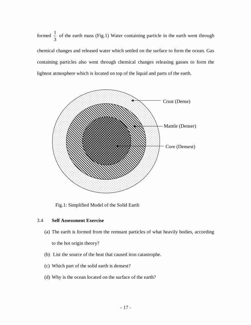
formed 31 of the earth mass (Fig.1) Water containing particle in the earth went through
chemical changes and released water which settled on the surface to form the ocean. Gas
containing particles also went through chemical changes releasing gasses to form the
lightest atmosphere which is located on top of the liquid and parts of the earth.
3.4 Self Assessment Exercise
(a) The earth is formed from the remnant particles of what heavily bodies, according
to the hot origin theory?
(b) List the source of the heat that caused iron catastrophe.
(c) Which part of the solid earth is densest?
(d) Why is the ocean located on the surface of the earth?
Crust (Dense)
Mantle (Denser)
Core (Densest)
Fig.1: Simplified Model of the Solid Earth
- 18 -
4.0 Conclusion
Earth originated from preexisting entities in the universe, be it particles or parts of
heavenly bodies. The internal and external parts of the earth are in a regular zone that
conformed to scientific reasoning.
5.0 Summary
I this unit you have learnt the following:
(i) Cold and hot origin theories of the earth
(ii) The characteristics of the earth that suit the development of life on it.
(iii) Iron catastrophe was caused by heat from particle accretion, gravitational
pulls and radioactive decay, the aftermath of which is earth zoning.
(iv) The solid earth has three basic sections V13 :crust, mantle and core
(v) Over 33% of the earth’s mass is iron
6.0 Tutor Marked Assignment
(1) List 5 conditions that make the planet earth a congenial place for living
things to survive.
(2) Explain the effects, if the distance of the earth from the sun were less or
more than what it is now.
(3) Justify the formations of ocean and atmosphere above the solid earth.
(4) Mention one weakness each of cold and hot origin theories of the earth.
- 19 -
7.0 Further readings and other resources
Dobrin, M.N. and Savit,C.H.,(1988): Introduction to Geophysical Prospecting. 4th. Ed. Mc Graw-Hill Book Co. N Y. Stacey, F.D. (1971): Physics of the Earth. John Wiley and sons. N.Y.
- 20 -
Module 1: Earth: Internal Structure and Constitution, Densities: Rocks And Ores
Unit 2: Motions of the earth
1.0 Introduction ----------------------------------------------------------------------------------2
2.0 Objectives ------------------------------------------------------------------------------------2
3.1 Types of motion of the earth --------------------------------------------------------------2
3.1.1 Revolution -----------------------------------------------------------------------------------3
3.1.2 Wobble----------------------------------------------------------------------------------------3
3.1.3 Rotation---------------------------------------------------------------------------------------4
3.2 Hypotheses about the Rotation of the Earth --------------------------------------------4
3.2.1 Cassini’s Hypothesis -----------------------------------------------------------------------4
3.2.2 Newtonian hypothesis ----------------------------------------------------------------------5
3.3 Self-assessment exercises 1----------------------------------------------------------------6
3.4 Effect of Rotation on the internal structure----------------------------------------------6
3.5 Earth shaping due to its rotation ----------------------------------------------------------7
3.6 Factors responsible for the sculpture of the Earth’s surface---------------------------8
3.7 Self-assessment exercises 2----------------------------------------------------------------9
4.0 Conclusion----------------------------------------------------------------------------------10
5.0 Summary------------------------------------------------------------------------------------10
6.0 Tutor marked assignment-----------------------------------------------------------------10
7.0 Further reading and resources------------------------------------------------------------11
- 21 -
1.0 Introduction
The non- stability of the planet earth is exemplified in various events such as
occurrence of day and night, seasonal variation as well as annual irregular length of days
and night are some of the evens that exemplified the movement of the earth. This unit
examines the various modes of motion like rotation, revolution, wobbling and their effect
such as centrifugal sorting and oblate nature of the earth.
2.0 Objectives
By the end of this unit you should be able to:
(a) Describe the three main types of motion of the earth
(b) State the effect of each of the three motions.
(c) Show diagrammatically the two hypotheses of earth’s rotation
(d) Explain the cause of the density variation of the solid earth
(e) Relate the centrifugal sorting to the density variation of the solid earth
3.1 Types of motion of the earth
The earth, in order to maintain celestial dynamic equilibrium with other
planets and other heavenly bodies, is under going series of complex motions. The
three major types of the motion whose effects are observable in our daily life are
discussed ahead.
- 22 -
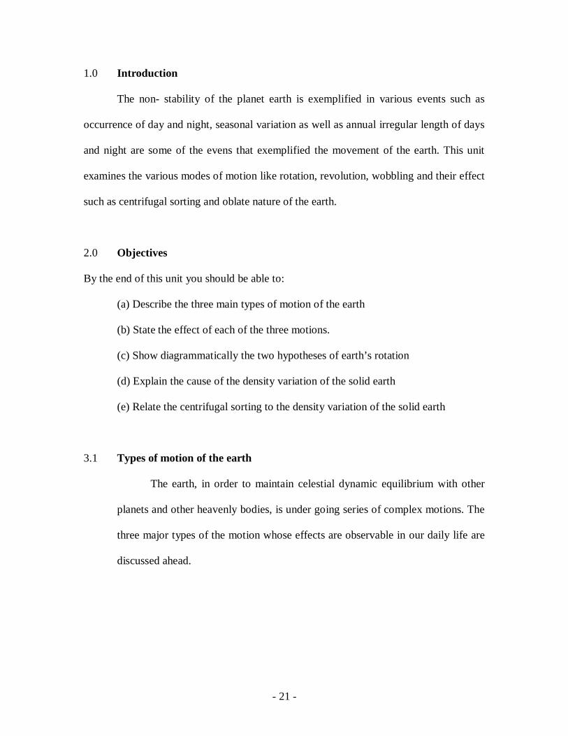
3.1.1 Revolution
The earth moves along an elliptical orbit whose plane is fairly perpendicular to
the polar axis of the earth. F1 and F2 are the foci of the orbit with sun at one of the foci.
This motion has a periodicity of 31557600 seconds (i.e. a year) and determines the global
season. The seasonal change is brought about as a result of earth distance from the sun at
each location on its orbit. For instance, at location B the earth is far from the sun, so the
sun’s heat may not be much to cause enough evaporation for much rain. At location A the
earth experiences much heat of the sun rays. This causes intense evaporation, leading to
rain possibility.
3.1.2 Wobble
Earth SuA
F2
B Polar Axis
Elliptical Orbit Fig.1: Revolutionary motion of the
earth
F1
Left flip
A
Right flip
B
Sun
Fig. 2: Flip-flop Motion of the Earth

- 23 -
The earth exhibits Flip-flop (wobble) motion about its equator as it is revolving
round the sun. It should be noted that northern hemisphere is closer to the sun than
southern hemisphere. Thus, northern hemisphere experiences longer day and shorter
night at this time; But reverse is the case at the location B.
3.1.3 Rotation
This is a rotation about polar axis from west to east in an anticlockwise direction,
viewing from the tip of the northern pole. The average period of earth’s rotation is
86400 seconds. (i.e. a day). Hence, rotation of the earth:
- determines the length of the day and night
- causes its ellipsoidal/oblate shape i.e. equatorial radius being longer than the
Polar radius
-results in density variation from the surface to the centre of the earth
3.2 Hypotheses about the Rotation of the Earth
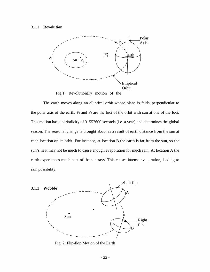
3.2.1 Cassini’s hypothesis
He proposed that the earth is rotating about the equator with the polar axis
perpendicular to the axis of rotation. If this is true then the earth will assume prolate
ellipsoid shape and one side of it would be experiencing permanent day light while the
other side would be in darkness permanently.
- 24 -
3.2.2 Newtonian Hypothesis
Newton hypothesised that the earth is rotating about the polar axis which lead
to the oblate ellipsoidal shape of the earth.
Fig.4: Newtonian Oblate Ellipsoidal Earth
Sun
Axis of rotation
Permanent night zone
Permanent day-light zone
Fig.3: Cassini’s Prolate Ellipsoidal earth
Polar axis
- 25 -
The geophysical evidence such as longer equatorial radius than the polar radius,
centrifugal sorting of the earth into its density regimes in which the density increases
from the surface towards the centre and occurrence of day and night support Newtonian
hypothesis.
3.3 Self-Assessment Exercise1
(i) Draw a wobbling earth with its poles in a vertical position.
(ii) What would be the length of days and nights when the earth wobbles to
the position you draw above?
(iii) List the practical experiences on the earth that negate Cassini’s hypothesis
on the rotation of the earth
(iv) Mention the practical experiences on the earth that supports Newtonian
hypothesis about the rotation of the earth.
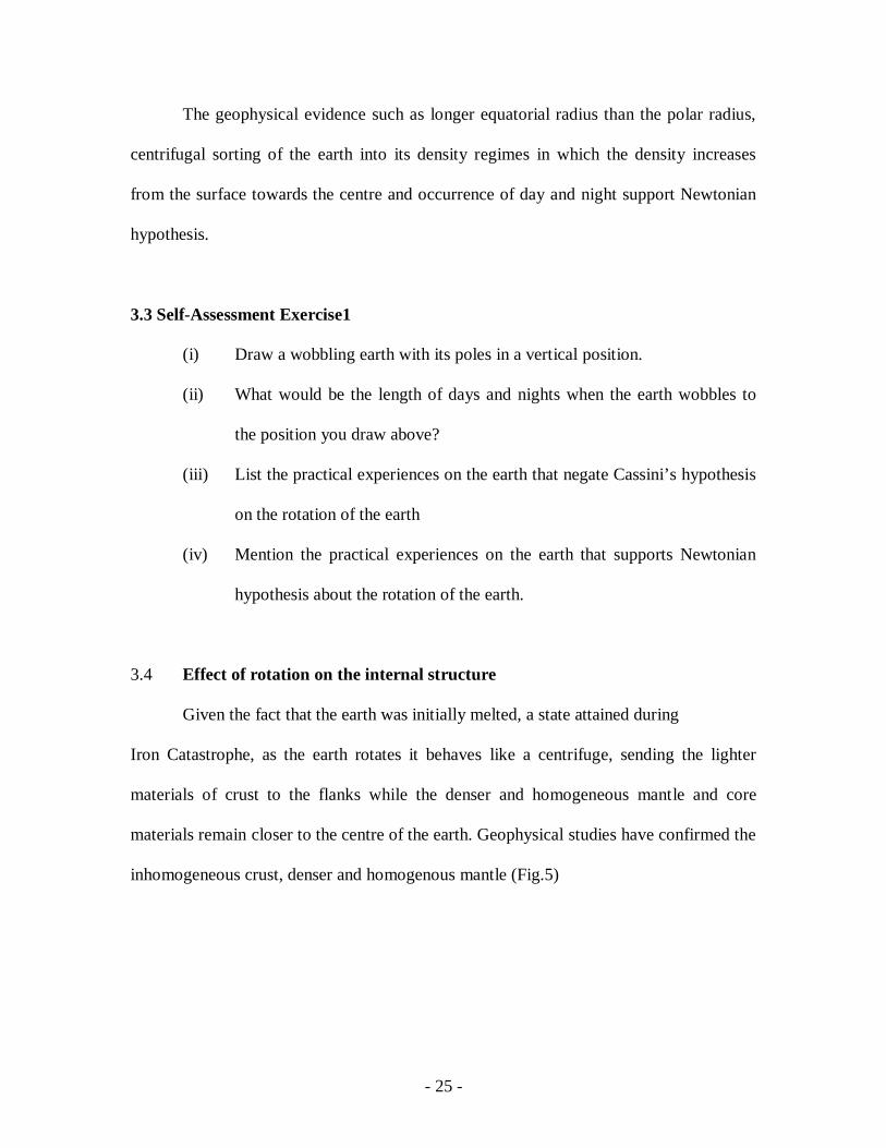
3.4 Effect of rotation on the internal structure
Given the fact that the earth was initially melted, a state attained during
Iron Catastrophe, as the earth rotates it behaves like a centrifuge, sending the lighter
materials of crust to the flanks while the denser and homogeneous mantle and core
materials remain closer to the centre of the earth. Geophysical studies have confirmed the
inhomogeneous crust, denser and homogenous mantle (Fig.5)

- 26 -
3.5 Earth Shaping due to its Rotation
Homogeneous layers
Inhomogeneous layer
A B C
Fig.5: Centrifugal Sorting of the Earth Interior
Equator Re
Rp
Cf C
C
Fig.6: Deviation of the Earth Shape from a Perfect Sphere
- 27 -
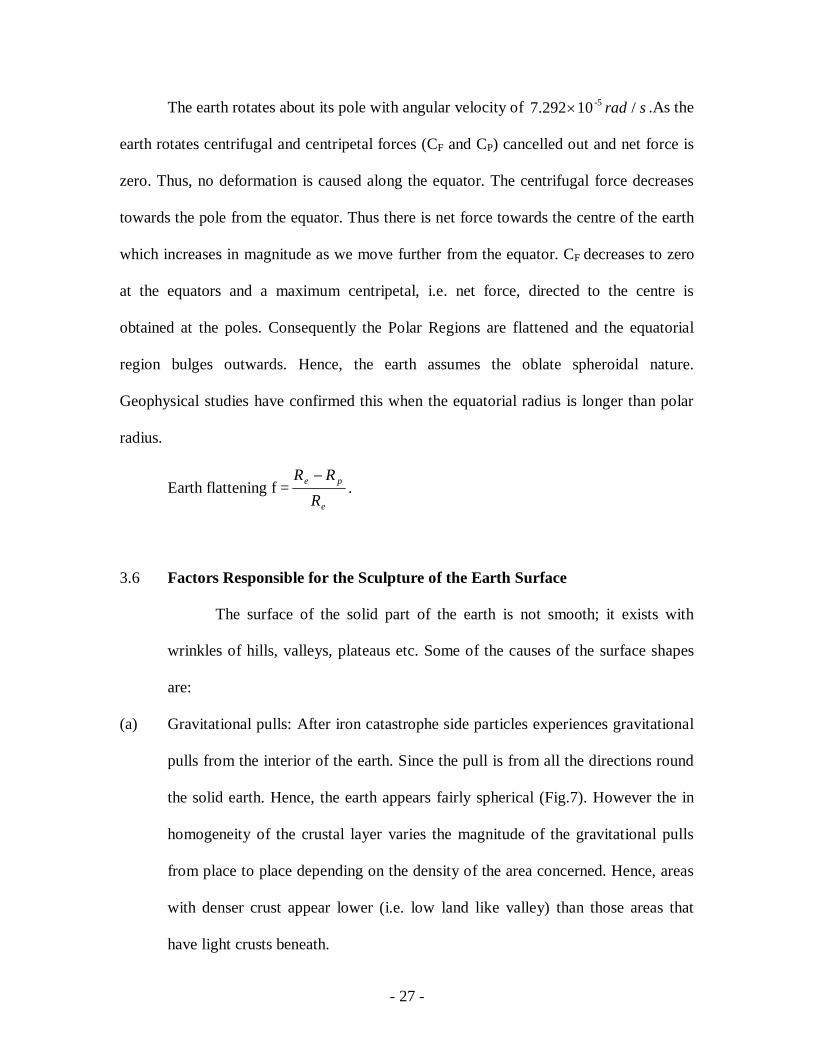
The earth rotates about its pole with angular velocity of srad /10 7.292 -5 .As the
earth rotates centrifugal and centripetal forces (CF and CP) cancelled out and net force is
zero. Thus, no deformation is caused along the equator. The centrifugal force decreases
towards the pole from the equator. Thus there is net force towards the centre of the earth
which increases in magnitude as we move further from the equator. CF decreases to zero
at the equators and a maximum centripetal, i.e. net force, directed to the centre is
obtained at the poles. Consequently the Polar Regions are flattened and the equatorial
region bulges outwards. Hence, the earth assumes the oblate spheroidal nature.
Geophysical studies have confirmed this when the equatorial radius is longer than polar
radius.
Earth flattening f =e
pe
RRR
.
3.6 Factors Responsible for the Sculpture of the Earth Surface
The surface of the solid part of the earth is not smooth; it exists with
wrinkles of hills, valleys, plateaus etc. Some of the causes of the surface shapes
are:
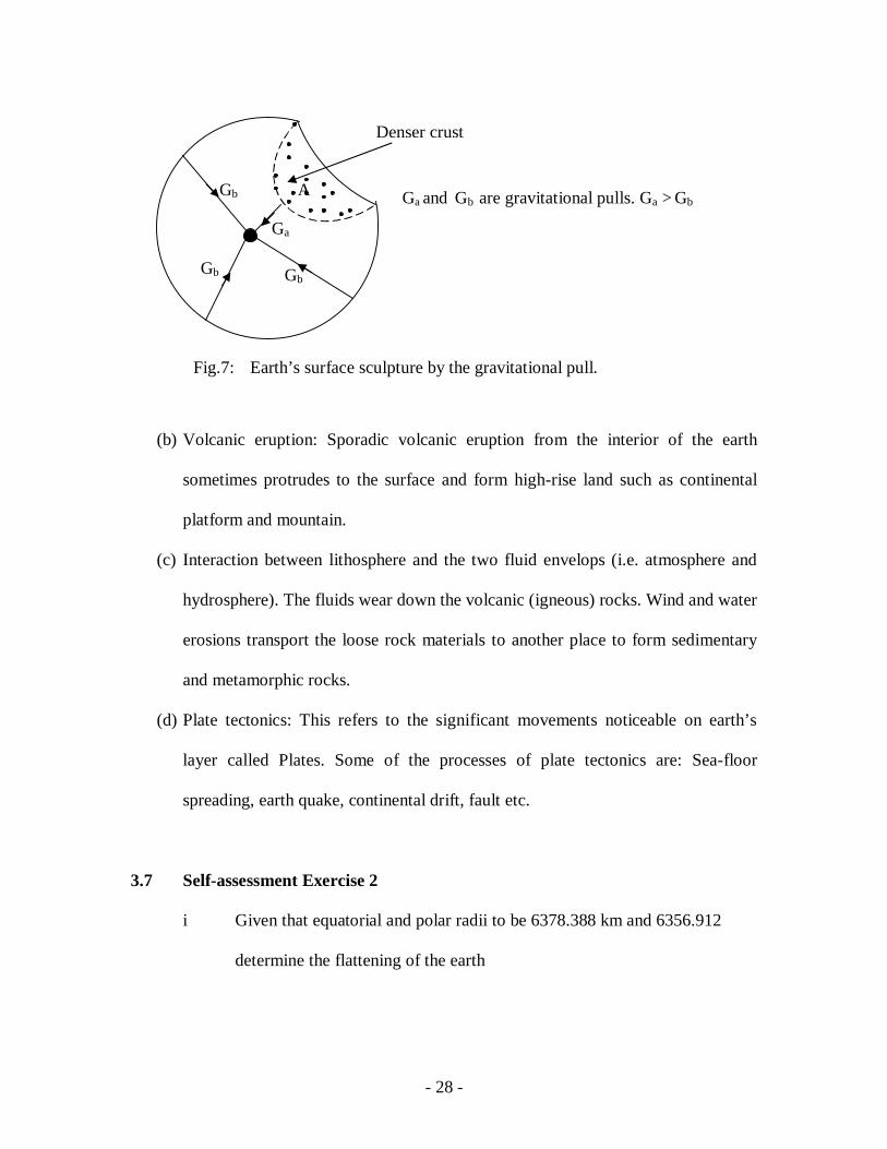
(a) Gravitational pulls: After iron catastrophe side particles experiences gravitational
pulls from the interior of the earth. Since the pull is from all the directions round
the solid earth. Hence, the earth appears fairly spherical (Fig.7). However the in
homogeneity of the crustal layer varies the magnitude of the gravitational pulls
from place to place depending on the density of the area concerned. Hence, areas
with denser crust appear lower (i.e. low land like valley) than those areas that
have light crusts beneath.
- 28 -
(b) Volcanic eruption: Sporadic volcanic eruption from the interior of the earth
sometimes protrudes to the surface and form high-rise land such as continental
platform and mountain.
(c) Interaction between lithosphere and the two fluid envelops (i.e. atmosphere and
hydrosphere). The fluids wear down the volcanic (igneous) rocks. Wind and water
erosions transport the loose rock materials to another place to form sedimentary
and metamorphic rocks.
(d) Plate tectonics: This refers to the significant movements noticeable on earth’s
layer called Plates. Some of the processes of plate tectonics are: Sea-floor
spreading, earth quake, continental drift, fault etc.
3.7 Self-assessment Exercise 2
i Given that equatorial and polar radii to be 6378.388 km and 6356.912
determine the flattening of the earth
Denser crust
Gb Gb
Gb A
Ga
Ga and Gb are gravitational pulls. Ga > Gb
Fig.7: Earth’s surface sculpture by the gravitational pull.
- 29 -
ii Give a condition for gravitational pull to give rise to a valley on the earth’s
surface
iii Explain the cause of the oblate spheroid shape of the earth
4.0 Conclusion
The earth experiences three main motions whose effects are observable on
earth. Most of the internal structure and constitution the geophysical studies have
direct links with the rotation of the earth.
5.0 Summary
In this unit we have learnt that:
(i) The earth experiences three types of motion
(ii) Rotation f the earth is responsible for the internal density distribution
and oblate spheroidal shape of the earth.
(iii) Newtonian hypothesis is most acceptable about the rotation of the earth
(iv) The four factors that is responsible for the shape of the earth’s surface.
6.0 Tutor marked assignment
i List the three (3) types of earth’s motion and mention one effect each of
the motion.
- 30 -
ii Sketch a diagram that can be used to explain Cassini’s hypothesis and
mention one weakness of the hypothesis as regards our daily experiences
on the earth’s surface.
iii How did the earth assume its fairly spherical shape?
7.0 Further readings and resources
Olatunji.S (2006): Detailed gravity study in part of Basement Complex of Northern Nigeria. PhD Dissertation; Ahmadu Bello University, Zaria, Nigeria. Telford W.M. , Geldart. L.P. Sheriff, R.E. and Keys, D.A (1976): Applied Geophysics Cambridge University Press, Cambridge.
Todhunter, I (1973): A History of Mathematical Theory of Attraction and the Figure of the Earth. Macmillan and Co. (Dover Publ. Inc; New York. 1962)
- 31 -
Module 1: Earth: Internal Structure and Constitution, Densities: Rocks And Ores
Unit 3: The internal and external structures of the earth.
1.0 Introduction----------------------------------------------------------------------------------2
2.0 Objective-------------------------------------------------------------------------------------2
3.1 Evidence in homogeneity of solid earth--------------------------------------------------2
3.2 Internal model of the solid earth----------------------------------------------------------3
3.2.1 Earth’s Model based on the chemical composition ------------------------------------3
3.2.2 Earth’s Model based on the edibility to flow -------------------------------------------6
3.3 Self- Assessment Exercise 1---------------------------------------------------------------7
3.4 Surface structure of the solid earth--------------------------------------------------------7
3.4.1 Formations of the continent, ocean and Atmosphere-----------------------------------7
3.4.2 Global distribution of the continent and ocean -----------------------------------------8
3.4.3 Significant surface features of the oceans.-----------------------------------------------8
3.5 Sequence of the solid earth’s surface ----------------------------------------------------9
3.6 Self assessment exercise 2-----------------------------------------------------------------9
4.0 Conclusion----------------------------------------------------------------------------------10
5.0 Summary -----------------------------------------------------------------------------------10
6.0 Tutor marked assignment ----------------------------------------------------------------10
7.0 Further readings and other resources. --------------------------------------------------11
1.0 Introduction
- 32 -
The internal structures of the solid earth are probed using some geophysical
methods. The information obtained are utilised to draw model of the pictures about the
interiors of the solid earth. Further, most of the features existing on the earth surface are
consequences of the events which either took place around the time of formation of the
earth or after mat effects of other event taking place with time. This unit deals with the
models of the interior structure of the earth based on the scientific facts. The causes and
structure of the external features of the solid earth are treated.
2.0 Objectives
By the end of this unit you would learn the following:
(a) Earth models based on the chemical composition and ability of the material to
flow.
(b) Evidence of in homogeneity of the earth crust
(c) Formation of three states of the earth.
(d) Global distribution and surface sequences of the ocean and continent.
3.1 Evidences of the Inhomogeneity of the Solid Earth
The crust is the layer closest to the surface of the solid earth. It is the layer that
shows high level of structural variations within the rock layers. The inhomogeneity of the
earth is shown in the following.
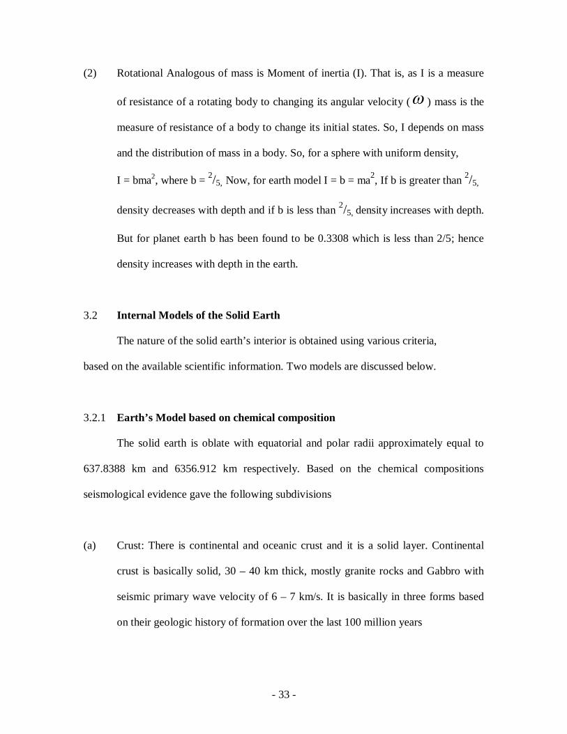
(1) Density variation: The surface density of the solid earth has been found to be
about 2.67g/cm3, but the average density of the earth is 5.5g/cm3. This implies that
deep beneath the earth’s surface is denser, i.e. density increases with depth.
- 33 -
(2) Rotational Analogous of mass is Moment of inertia (I). That is, as I is a measure
of resistance of a rotating body to changing its angular velocity ( ) mass is the
measure of resistance of a body to change its initial states. So, I depends on mass
and the distribution of mass in a body. So, for a sphere with uniform density,
I = bma2, where b = 2/5, Now, for earth model I = b = ma2, If b is greater than 2/5,
density decreases with depth and if b is less than 2/5, density increases with depth.
But for planet earth b has been found to be 0.3308 which is less than 2/5; hence
density increases with depth in the earth.
3.2 Internal Models of the Solid Earth
The nature of the solid earth’s interior is obtained using various criteria,
based on the available scientific information. Two models are discussed below.
3.2.1 Earth’s Model based on chemical composition
The solid earth is oblate with equatorial and polar radii approximately equal to
637.8388 km and 6356.912 km respectively. Based on the chemical compositions
seismological evidence gave the following subdivisions
(a) Crust: There is continental and oceanic crust and it is a solid layer. Continental
crust is basically solid, 30 – 40 km thick, mostly granite rocks and Gabbro with
seismic primary wave velocity of 6 – 7 km/s. It is basically in three forms based
on their geologic history of formation over the last 100 million years
- 34 -
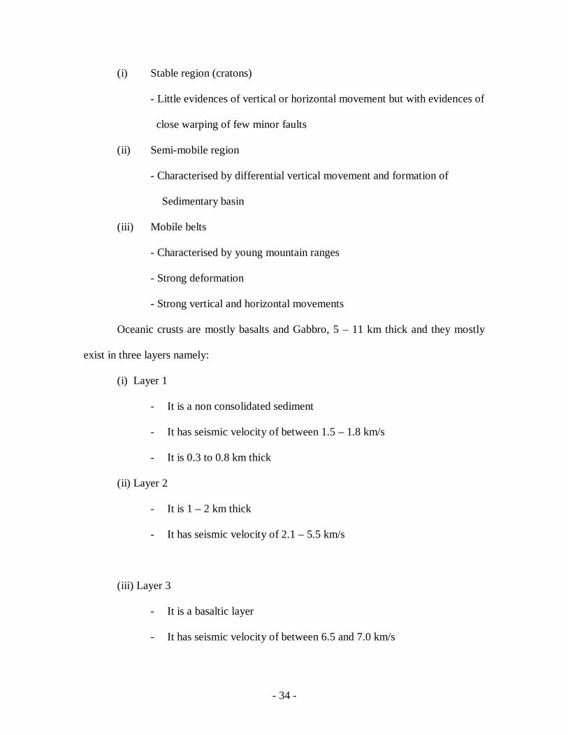
(i) Stable region (cratons)
- Little evidences of vertical or horizontal movement but with evidences of
close warping of few minor faults
(ii) Semi-mobile region
- Characterised by differential vertical movement and formation of
Sedimentary basin
(iii) Mobile belts
- Characterised by young mountain ranges
- Strong deformation
- Strong vertical and horizontal movements
Oceanic crusts are mostly basalts and Gabbro, 5 – 11 km thick and they mostly
exist in three layers namely:
(i) Layer 1
- It is a non consolidated sediment
- It has seismic velocity of between 1.5 – 1.8 km/s
- It is 0.3 to 0.8 km thick
(ii) Layer 2
- It is 1 – 2 km thick
- It has seismic velocity of 2.1 – 5.5 km/s
(iii) Layer 3
- It is a basaltic layer
- It has seismic velocity of between 6.5 and 7.0 km/s
- 35 -
- It is 5 km thick
(b) Mohorovicic Boundary: It is chemical boundary separating silicic crustal
rock with high Feldspar content from underlying Ultramafic rocks of mantle.
(c) Mantle: It is a solid layer and is about 2900 km thick. It is the largest of all
the subdivisions, 84% by volume and 69% mass of the entire earth and divided
into 3 zones namely:
(i) Upper mantle
- Mineralization of upper mantle is approximately 40% Olivine, 50%
Pyroxene and 10% Garnet
(ii) Transition layer
- It is characterised by abrupt increase in seismic velocity which is
attributed to phase change
- It is iron rich
(iii) Lower Mantle
- Seismic velocity and density increase steadily with depth
- It has velocity homogeneity
(b) Gutenberg Boundary: It is a discontinuity between the mantle an the core
(c) Core: It is 16% and 13% by volume and mass of the earth. It is about 3470 km
thick extended to the centre of the earth and is in 3 zones namely:
(1) Outer core
- It is about 2080 km thick
- 36 -
- It is believed to be in liquid form because seismic S – Wave cannot
pass through it
- Earth’s magnetic field originates from it
- The response of the earth to tidal forces which affects axis of rotation
and the centrifugal force that counter the centripetal force along the
equator, which is responsible for the bulginess of the earth at the
equator, are associated with the liquid nature of the outer core
(ii) Transition zone
It is a slightly rigid shell (140 km thick) surrounding the solid inner core
with temperature of about 3000 kelvins which is about the melting point of
iron.
(iii) Inner core
It is 1250 km thick, solid and with P – wave velocity increase inward,
which implies density increase.
3.2.2 Earth’s Model based on Ability to flow
Earth model can be drawn based on the ability of its layer to flow. The layers are:
1 Lithosphere- cold and brittle.
flowtocapablereRheonospheereAsthonosph
32
It was reported that towards the centre it becomes hardened again as a result of
pressure.
3.3 Self – Assessment exercise 1
- 37 -
(i) What is the source of the centrifugal force that is responsible for the bulginess of
the earth?
(ii) How does the density vary from the crust to the core?
(iii) Briefly discuss the evidences to confirm that the earth crust is density in
homogenous
3.4 Surface Structure of the Solid Earth
The surface of the solid earth witnessed series of features such as oceans and
continents which are consequences of geological events that took place over a long
period of time; some of the features are explained below.
3.4.1 Formation of Continents, Ocean and Atmosphere
(i) Continents: Lava flows as a result of volcanism from the interior to
the outer layer cooled and became continent.
(ii) Oceans: From the interior of the solid earth as a product of the
Process of heating up and differentiation, some water bearing elements
released their water molecules which accumulate on the surface to form the
oceanic water.
(iii) Atmosphere: Out-gassing , resulting from differentiation and some gas releasing
chemical reactions brought about much gasses that accumulated above the solid
earth.
3.4.2 Global distribution of continents and oceans
- 38 -
About 45% of the earth surface has sea-sea antipodal and 1.4% has land-land
antipodal. Northern hemisphere has 60% land and 40% water, while southern hemisphere
has 61% water and 39% land. In general, earth’s surface has 29% continent and 71% is
covered by ocean. The total world area is approximately 2610510 km .
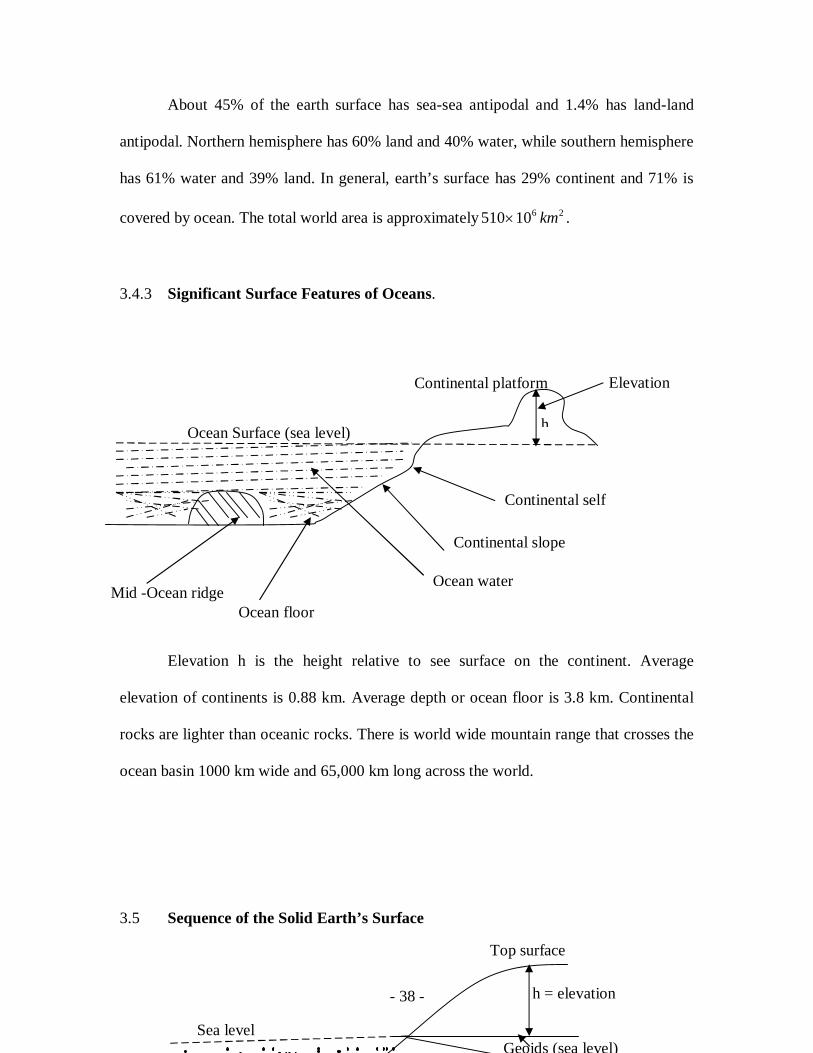
3.4.3 Significant Surface Features of Oceans.
Elevation h is the height relative to see surface on the continent. Average
elevation of continents is 0.88 km. Average depth or ocean floor is 3.8 km. Continental
rocks are lighter than oceanic rocks. There is world wide mountain range that crosses the
ocean basin 1000 km wide and 65,000 km long across the world.
3.5 Sequence of the Solid Earth’s Surface
Ocean Surface (sea level)
Continental self
Continental slope
Ocean water
Ocean floor Mid -Ocean ridge
h
Elevation Continental platform
Sea level
Top surface
h = elevation
Geoids (sea level)
- 39 -
The earth’s surface is basically viewed in three forms:
(i) The top surface is the continental platform wrinkled in nature.
(ii) Geoids is the sea level, where sea water will flow to if the continent were
to be tunnelled. In other word, geoid is the equipotential surface to
which direction of gravity field is everywhere perpendicular. The vertical
separation between the geoids and a point on the earth’s surface is
the elevation.
(iv) Ellipsoid is the ideal smooth surface of the earth in its oblate form. It
sometimes coincides with geoids, but sometimes not.
3.6 Self-assessment Exercise 2
(1) What percentage of the earth’s surface is not covered by ocean water?
(2) Define ellipsoid
(3) What other name can you call a geoid?
(4) How did the ocean form?
- 40 -
4.0 Conclusion
The interior of the earth compose of crust, mantle and core where the
characteristics of each layer varies based on scientific evidences. Most of the surface
structures of the earth are consequences of events that originated from the solid earth.
5.0 Summary
In this unit you have learnt:
(i) The two models of the solid earth drawn from the chemical composition
information and ability of the materials to flow.
(ii) That earth crust is not homogeneous based on evidences such as density
Variation.
(iii) The formations of the continent and as major surface features of the solid
Earth.
(iv) The global distributions of the continents and ocean.
(v) The meanings of ellipsoid, geoids and elevation, the major sequence of the
earth’s surface.
6.0 Tutor Marked Assignment
(i) Sketch a model of the solid earth based on the chemical composition
showing the 5 major internal features, thickness and an ocean.
(ii) Explain three major significant effects of the outer core to the scientific
observations on the earth.

- 41 -
7.0 Further Reading and Resources
Gerken, J.C d’Arnaud, (1989): Foundation of Exploration Geophysics: Amsterdam, Elsevier Science Publishers. Lawyer, L.C.,Bates, Charles, C. and Rice, Robert, B. (2001): Geophysics in the Affairs of Mankind. Society Exploration Geophysicists. Tulsa, Oklahoma. Vanček, P. and Krakiwsky, E.j. (1986): Geodesy: The concepts.2. rev. ed., Elseevier Scient. Publ. comp., Amsterdam.
- 42 -
Module 1: Earth: Internal Structure and Constitution, Densities: Rocks And Ores
Unit 4: Variation of some physical properties within the solid earth
.
3.0 Introduction----------------------------------------------------------------------------------2
4.0 Objective-------------------------------------------------------------------------------------2
3.1 Variation of Density with depth. ---------------------------------------------------2
3.2 Variation of pressure P with depth -------------------------------------------------------4
3.3 Variation of Acceleration due to gravity with depth-----------------------------------4
3.4 Variation of Pressure P and S waves with depth----------------------------------------4
3.5 Self Assessment Exercise------------------------------------------------------------------6
4.0 Conclusion-----------------------------------------------------------------------------------6
5.0 Summary -------------------------------------------------------------------------------------6
6.0 Tutor marked assignment ------------------------------------------------------------------7
7.0 Further readings and other resources. ----------------------------------------------------7
- 43 -
1.0 Introduction
Some parameters vary with depth (i.e. radius of earth).Measurement of these on
the surface gives due to the structure of the underlying interior of the earth. The deals
with variation of density pressure, gravitational field, Velocity and temperature with
depth within the earth’s rocks.
2.0 Objectives
At the end of this unit you should be able to:
(1) describe the trend of variation of pressure, density, gravitational field, and seismic
velocity as well and with depth in the solid earth.
(2) derive the mathematical relations for the variation of parameter itemised in (1)
(3) Apply the mathematical formula to real life events
3.1 Variation of Density with depth
Consider density dependent on pressure P and temperature T. That
is
)1(),( TP
Assuming that the stress in the earth’s interior is equal to hydrostatic pressure ),( gh then
pressure gradient towards the centre of the earth.
)2( gdrdp
r is the radius of the earth. The negative sign implies pressure increase with decrease in
radius. Consider a homogeneous layer in which the t temperature variation is adiabatic
then.
- 44 -
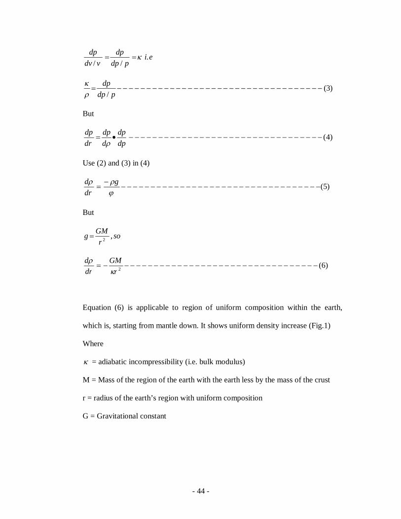
eipdp
dpvdv
dp .//
)3(/
pdp
dp
But
)4(dpdp
ddp
drdp
Use (2) and (3) in (4)
)5(
g
drd
But
sor
GMg ,2
)6(2 r
GMdrd
Equation (6) is applicable to region of uniform composition within the earth,
which is, starting from mantle down. It shows uniform density increase (Fig.1)
Where
= adiabatic incompressibility (i.e. bulk modulus)
M = Mass of the region of the earth with the earth less by the mass of the crust
r = radius of the earth’s region with uniform composition
G = Gravitational constant
- 45 -
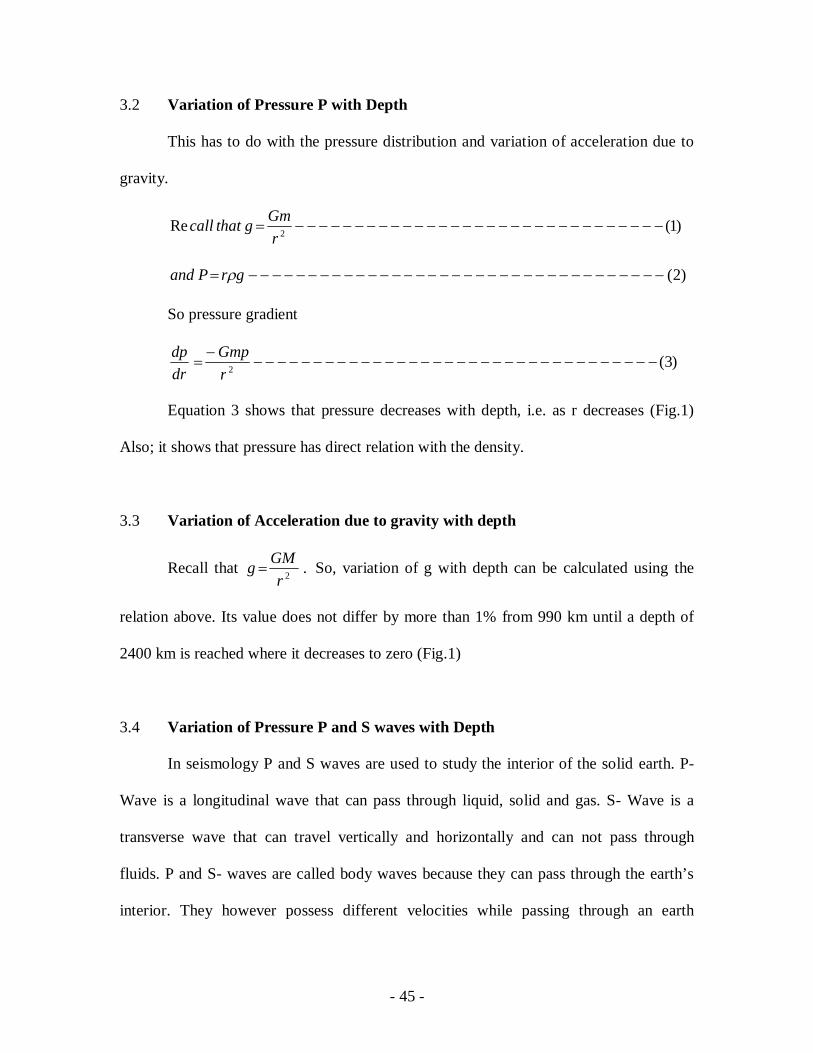
3.2 Variation of Pressure P with Depth
This has to do with the pressure distribution and variation of acceleration due to
gravity.
)1(Re 2 r
Gmgthatcall
)2( grPand
So pressure gradient
)3(2
rGmp
drdp
Equation 3 shows that pressure decreases with depth, i.e. as r decreases (Fig.1)
Also; it shows that pressure has direct relation with the density.
3.3 Variation of Acceleration due to gravity with depth
Recall that .2rGMg So, variation of g with depth can be calculated using the
relation above. Its value does not differ by more than 1% from 990 km until a depth of
2400 km is reached where it decreases to zero (Fig.1)
3.4 Variation of Pressure P and S waves with Depth
In seismology P and S waves are used to study the interior of the solid earth. P-
Wave is a longitudinal wave that can pass through liquid, solid and gas. S- Wave is a
transverse wave that can travel vertically and horizontally and can not pass through
fluids. P and S- waves are called body waves because they can pass through the earth’s
interior. They however possess different velocities while passing through an earth
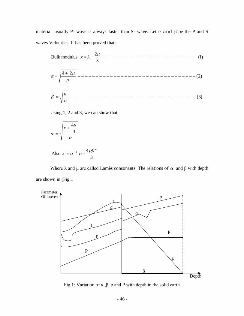
- 46 -
material. usually P- wave is always faster than S- wave. Let and β be the P and S
waves Velocities. It has been proved that:
)1(3
2 modulusBulk
)2(2
)3(
Using 1, 2 and 3, we can show that
3
4
Also 3
4 22
Where λ and μ are called Lamês consonants. The relations of and β with depth
are shown in (Fig.1
Depth
β
α
P
ρ
ρ
P
α
β
g
g
Fig.1: Variation of α ,β, ρ and P with depth in the solid earth.
Parameter Of Interest
- 47 -
3.5 Self assessment Exercise
(1) State the mathematical relation for hydrostatic pressure.
(2) What is the implication of the negative sign in the density gradient
expression in equation (6)?
(3) Sketch the variation of pressure and density with depth, state one
similarity and difference each.
4.0 Conclusion
It has been established that density, pressure, and seismic velocities, vary
differently with depth within the solid earth. The models developed are easily applicable
to layer below the crust where there is some element of homogeneity than in the crust that
is characterised by inhomogeneity.
5.0 Summary
At the end of this unit you have learnt that:
(i) density is directly proportional to depth,
2rGm
drdinshowas
(ii) Pressure is inversely proportional to depth,
2rGm
drdpinshowas
(iii) Acceleration due to gravity increases with depth up to a point when it then
decreases to zero
(iii) Seismic waves vary differently with depth.
- 48 -
6.0 Tutor Marked Assignment
(1)
,3
2
:
thatGiven
and
2
34Pr thatove
(2) With the aid of a diagram, describe the variation of S- wave velocity in a
homogeneous part of the solid earth.
7.0 Further Reading and Resources
Ben- Zion, Yehuda; Lee, William, H.K.L. (Eds.) (2006): Advances in Studies of Heterogeneities in the earth’s Lithosphere Pageoph Tropical volume. The Keiiti Aki, vol. II.A Birkhäuser Book. Telford, W.M., Geldart, L.P., Sheriff, R.E. and Keys, D.A. (1976): Applied Geophysics. Cambridge University Press, London