Embed Size (px)
Citation preview
NPS Form 10-900 OMBNo. 10024-0018
United States Department of the Interior National Park Service
National Register of Historic Place§ Registration Form
AU6 - 7 2000
KAIREGlSTER'oTHiSTORFNATIONAL PARK <?pi
This form is for use in nominating or requesting determination for individual pr Juyi lius di id Uislriela. 4. ___ Complete the National Register of Historic Places Registration Form (National Register Bulletin 16A). Complete
RECEIVED ?280
markin docum enter o sheets
I "x" in the appropriate box or by entering the information requested. If an Item does not apply to >nted, enter * N/A" for "not applicable." For functions, architectural.classification, materials and a
ion in How to each item by
_ the property bein areas of significan
nly categories and subcategones from the instructions. Place additional entries and narrative items on continuation (NPS Form 10-900a). Use a typewriter, word processor, or computer, to complete all items.
g ce,
1. Name of Property
historic name Rourke Ranch Historic District
other names/site number 5LA8813
2. Location
street & number Comanche National Grassland
city or town La Junta_____________
state Colorado
[N/A] not for publication
___ [ X ] vicinity
code CO county Las Animas code 071 zip code 81050
3. State/Federal Agency Certification
As the designated authority under the National Historic Preservation Act, as amended, I hereby certify that this [X] nomination [ ] request for determination of eligibility meets the documentation standards for registering properties in the National Register of Historic Places and meets the procedural and professional requirements set forth in 36 CFR Part 60. In my opinion, the property [ X ] meets [ ] does not meet the National Register criteria. I recommend that this property be considered significant [ ] nationally [ ] statewide [ X ] locally. ([ ] See continuation sheet for additional comments.)
s&' ̂___________^^___________ state Historic Preservation Officer
'signature or certiryfliQ official/1 me
State Historic Preservation Office. Colorado Historical Society State or Federal agency and bureau
In my opinion, the property^] meets [ ] does not meet the National Register criteria. ([ ] See continuation sheet jpr additional comments.)
^MLAs. ^ /7\.Signature of certfying offi
State or Federal agency and bureau
4. National Park Service CertificationI hereby certify that the property is:
[/{eentered in the National Register[ ] See continuation sheet.
[ ] determined eligible for theNational Register[ ] See continuation sheet.
[ ] determined not eligible for theNational Register.
[ ] removed from theNational Register
[ ] other, explain[ ] See continuation sheet.
Signature of the Keeper Date or Action
Rourke Ranch Historic District Name of Property__________
Las Animas County. ColoradoCounty/State
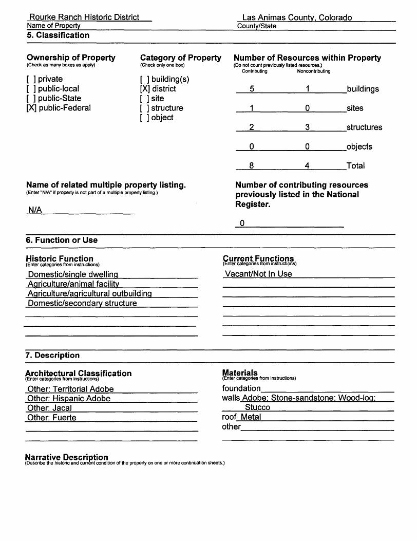
5. Classification
Ownership of Property(Check as many boxes as apply)
[ ] private [ ] public-local [ ] public-State [X] public-Federal
Category of Property(Check only one box)
[ ] building(s) [X] district [ ] site [ ] structure [ ] object
Number of Resources within Property(Do not count previously listed resources.)
Contributing Noncontributing
5
1
2
0
8
1
0
3
0
4
buildings
sites
structures
objects
Total
Name of related multiple property listing.(Enter "N/A" if property is not part of a multiple property listing.)
N/A
Number of contributing resources previously listed in the National Register.
0
6. Function or Use
Historic Function(Enter categories from instructions)
Domestic/single dwellingAgriculture/animal facility
Current Functions(Enter categories from instructions)
Vacant/Not In Use
Agriculture/agricultural outbuilding Domestic/secondary structure
7. Description
Architectural Classification(Enter categories from instructions)
Other: Territorial AdobeOther: Hispanic AdobeOther: JacalOther: Fuerte
Materials(Enter categories from instructions)
foundation________________ walls Adobe: Stone-sandstone: Wood-log; ___Stucco_______________ roof Metal________________ other
Narrative Description(Describe the historic and current condition of the property on one or more continuation sheets.)
Rourke Ranch Historic District Name of Property__________
Las Animas County. ColoradoCounty/State
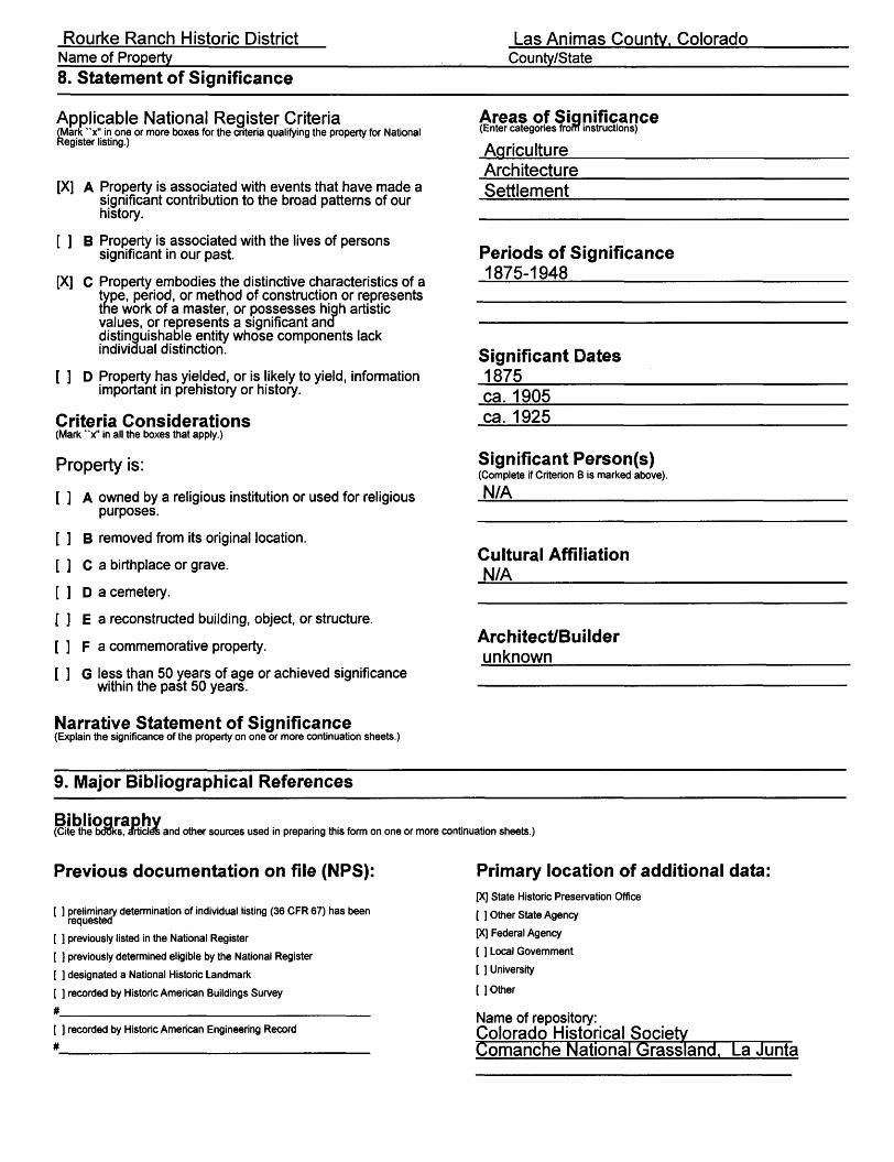
8. Statement of Significance
Applicable National Register Criteria(Mark "x" in one or more boxes for the criteria qualifying the property for National Register listing.)
[X] A Property is associated with events that have made a significant contribution to the broad patterns of our history.
[ ] B Property is associated with the lives of persons significant in our past.
[X] C Property embodies the distinctive characteristics of a type, period, or method of construction or represents the work of a master, or possesses high artistic values, or represents a significant ana distinguishable entity whose components lack individual distinction.
[ ] D Property has yielded, or is likely to yield, information important in prehistory or history.
Criteria Considerations(Mark "x" in all the boxes that apply.)
Property is:
[ ] A owned by a religious institution or used for religious purposes.
[ ] B removed from its original location.
[ ] C a birthplace or grave.
[ ] D a cemetery.
[ ] E a reconstructed building, object, or structure.
[ ] F a commemorative property.
[ ] G less than 50 years of age or achieved significance within the past 50 years.
Narrative Statement of Significance(Explain the significance of the property on one or more continuation sheets.)
Areas of Significance(Enter categories from instructions)(Enter categories fro
AgricultureArchitectureSettlement
Periods of Significance1875-1948
Significant Dates1875ca. 1905ca. 1925
Significant Person(s)(Complete if Criterion B is marked above).
N/A
Cultural AffiliationN/A
Architect/Builderunknown __
9. Major Bibliographical References
Bibliography(Cite the books, article's and other sources used in preparing this form on one or more continuation sheets.)
Previous documentation on file (NPS):
[ ] preliminary determination of individual listing (36 CFR 67) has been requested
[ ] previously listed in the National Register
[ ] previously determined eligible by the National Register
[ ] designated a National Historic Landmark
[ ] recorded by Historic American Buildings Survey
[ ] recorded by Historic American Engineering Record
Primary location of additional data:[X] State Historic Preservation Office
[ ] Other State Agency
[X] Federal Agency
[ ] Local Government
[ ] University
[ ] Other
Name of repository:Colorado Historical SocietyComanche National Grassland. La Junta
Rourke Ranch Historic District Name of Property__________
Las Animas County. ColoradoCounty/State
10. Geographical Data
Acreage of Property 200.0 acres
UTM References(Place additional UTM references on a continuation sheet.)
1. 13 619.180 4160990 Zone Easting Northing
3. 13 620000 Zone Easting
4161800Northing
2. 13 620.080 Zone Easting
4161000Northing
Verbal Boundary Description(Describe the boundaries of the property on a continuation sheet.)
Boundary Justification(Explain why the boundaries were selected on a continuation sheet.)
4. 13Zone
620.370Easting
4161840 Northing
[ X ] See continuation sheet
11. Form Prepared By
name/title Jonathon C. Horn / Principal investigator: revised by SHPO staff__________
organization Alpine Archaeological Consultants. Inc.________ date 9/1999: 4/2000
street & number P. O. Box 2075___________________ telephone 970-249-6761
city or town Montrose____________ state Colorado zip code 81402-2075
Additional Documentation
Submit the following items with the completed form:
Continuation Sheets
MapsA USGS map (7.5 or 15 minute series) indicating the property's location.A Sketch map for historic districts and properties having large acreage or numerous resources.
PhotographsRepresentative black and white photographs of the property.
Additional Items(Check with the SHPO or FPO for any additional items)
Property Owner(Complete this item at the request of SHPO or FPO.)
name Comanche National Grassland_____________________
street & number 1420 East 3rd Street telephone 719-384-2181
city or town La Junta state Colorado zip code 81050Paperwork Reduction Act Statement: This information is being collected for applications to the National Register of Historic Places tp nominate properties for listing or determine eligibility for listing, to list properties, and to amend existing listings. Response to this request is required to obtain a benefit in accordance with the National Historic Preservation Act, as amended (16 U.S.C. 470 etseq.
NPS Form 10-900a 0MB No. 1024-0018 (Rev. 8/86)
United States Department of the InteriorNational Park Service
National Register of Historic PlacesContinuation Sheet
Rourke Ranch Historic District Section number J_ Page J_ Las Animas County, CO
DESCRIPTION
Rourke Ranch is the centerpiece of the Picket Wire Canyonlands, a reserve managed by the Comanche National Grassland. The ranch is situated in the plains of southeastern Colorado on the north side of the Purgatoire River near the mouth of Bent Canyon at an elevation of 4,410 feet. Much of the property is on nearly level ground covered with grasses and cholla cactus. Juniper trees are located on the breaks of the Purgatoire River canyon to the north. Riparian species, including groves of cottonwoods, are present along the Purgatoire River to the south and east.
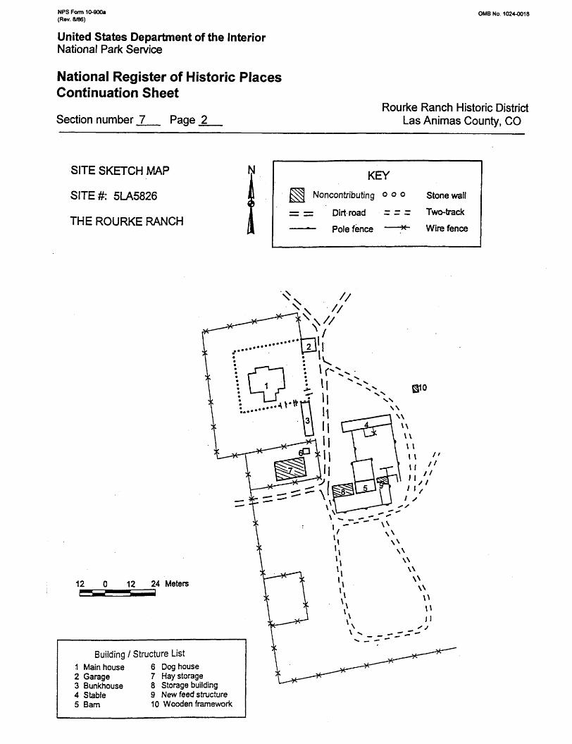
The Rourke Ranch Historic District includes the original Eugene Rourke homestead (5LA6400) [now an historical archaeological site], the Rourke Ranch Headquarters (5LA5826), and a large corral with an elongated stone calving shed (5LA6533). The homestead is near the head of Bent Canyon adjacent to the floodplain of the Purgatoire River. Flooding in September 1904 forced abandonment of this original ranchstead and by the next year a new ranch headquarters (5LA5826) was constructed about 0.6 miles to the northeast. The large corral and stone animal shed, which became an integral part of the ranching operation, was built near the original homestead in about 1925.
Rourke Ranch Headquarters (5LA5826)
Eugene Rourke established the ranch headquarters at this location after a flood destroyed an earlier homestead at the mouth of Bent Canyon. Construction of this ranchstead presumably began after the flood and was completed either in late 1904 or early 1905. The buildings are located in a wide flat canyon bottom with hills surrounding the site. All the buildings and structures are within 300 feet of each other. The original buildings are the main house, stable, and barn. The log (fuerte) barn andjacal stable were probably built at the same time as the main adobe house or shortly thereafter. A map submitted as evidence of improvements made to the claim show a house, barn, and a stable on the site in 1908 (National Archive Patent No. 46459, Desert Land Entry filed by Mary E. Rourke). The adobe doghouse was apparently constructed by about 1910. The stone garage and the adobe bunkhouse were built by 1920. The stone garage may have been the "machine house" Eugene Rourke listed as an improvement to his claim in the Third Yearly Proof of the Desert Land Entry in 1911. The improvements of a machine house and a "shed" were valued at 75 dollars (National Archives, Patent No. 465459). All these constructions built prior to 1920 are considered contributing elements to the historic district. From the 1950s to the early 1970s, the hay storage structure, the cinder block storage building and the cinder block feed structure were added (Haynes and Bastian 1987). There is also a small wooden framework that served as a gasoline tank platform. None of these later constructions are considered contributing elements.
NFS Form 10-900a (Rev. 8/86)
OMB No. 1024-0018
United States Department of the InteriorNational Park Service
National Register of Historic Places Continuation Sheet
Section number J_ Page 2_Rourke Ranch Historic District
Las Animas County, CO
SITE SKETCH MAP
SITE#: 5LA5826
THE ROURKE RANCH
KEYNoncontributing o o o
= = Dirt road - - ~ ——— Pole fence ——*~
Stone wall
Two-track
Wire fence
12 12 24 Meters
Building / Structure List1 Main house 6 Doghouse2 Garage 7 Hay storage3 Bunkhouse 8 Storage building4 Stable5 Bam
9 New feed structure10 Wooden framework
NFS Form 10-900a OMB No. 1024-0018 (Rev. 8/86)
United States Department of the InteriorNational Park Service
National Register of Historic Places Continuation Sheet
Rourke Ranch Historic District Section number 1__ Page _3_ Las Animas County, CO
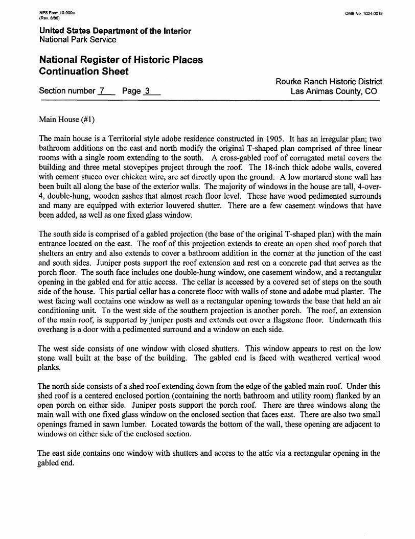
Main House
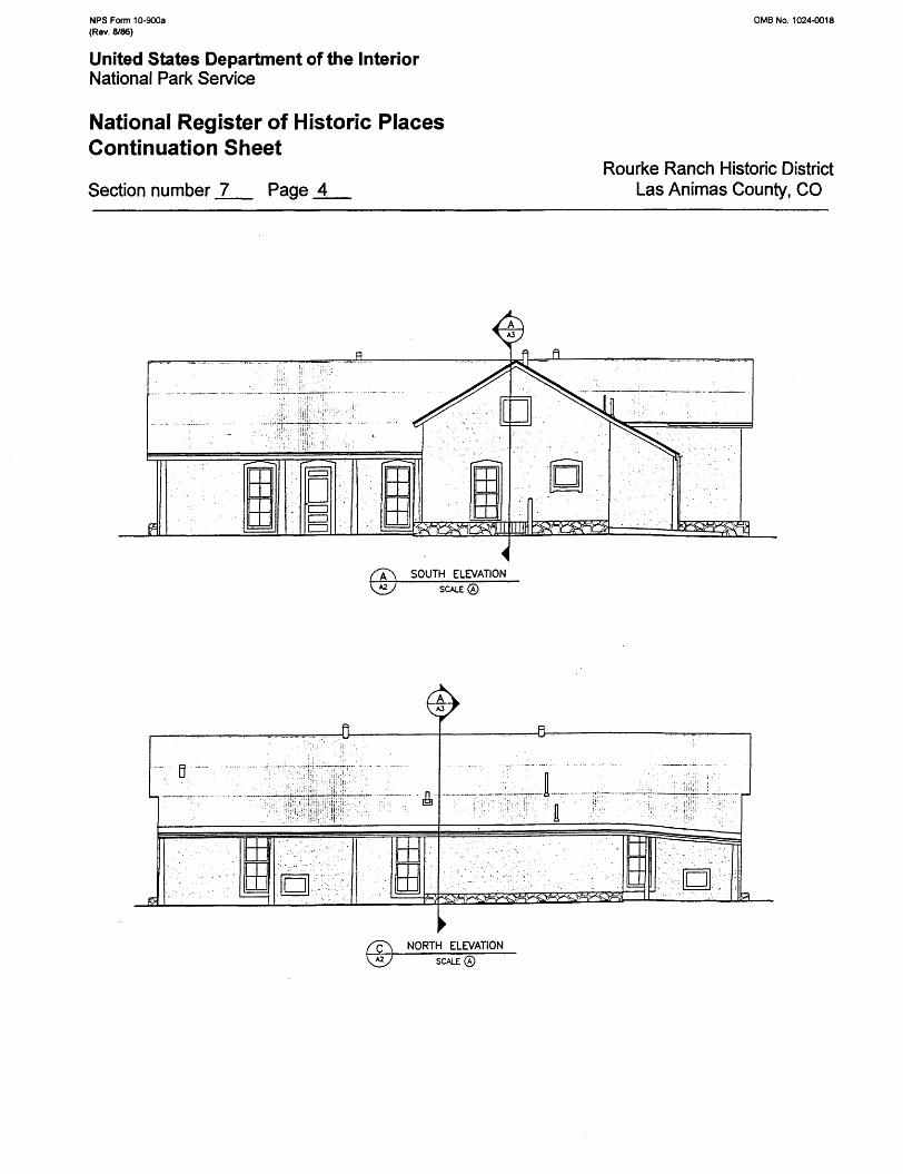
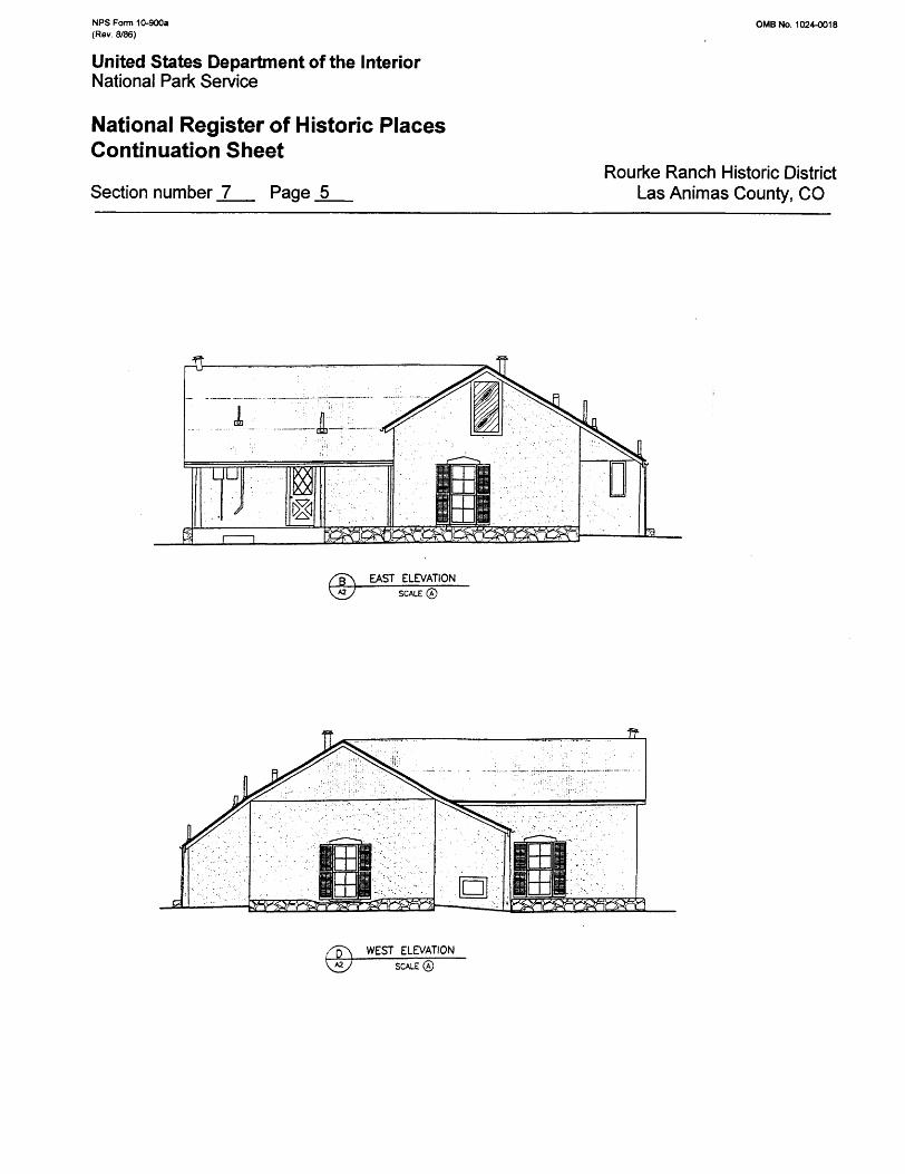
The main house is a Territorial style adobe residence constructed in 1905. It has an irregular plan; two bathroom additions on the east and north modify the original T-shaped plan comprised of three linear rooms with a single room extending to the south. A cross-gabled roof of corrugated metal covers the building and three metal stovepipes project through the roof. The 18-inch thick adobe walls, covered with cement stucco over chicken wire, are set directly upon the ground. A low mortared stone wall has been built all along the base of the exterior walls. The majority of windows in the house are tall, 4-over- 4, double-hung, wooden sashes that almost reach floor level. These have wood pedimented surrounds and many are equipped with exterior louvered shutter. There are a few casement windows that have been added, as well as one fixed glass window.
The south side is comprised of a gabled projection (the base of the original T-shaped plan) with the main entrance located on the east. The roof of this projection extends to create an open shed roof porch that shelters an entry and also extends to cover a bathroom addition in the corner at the junction of the east and south sides. Juniper posts support the roof extension and rest on a concrete pad that serves as the porch floor. The south face includes one double-hung window, one casement window, and a rectangular opening in the gabled end for attic access. The cellar is accessed by a covered set of steps on the south side of the house. This partial cellar has a concrete floor with walls of stone and adobe mud plaster. The west facing wall contains one window as well as a rectangular opening towards the base that held an air conditioning unit. To the west side of the southern projection is another porch. The roof, an extension of the main roof, is supported by juniper posts and extends out over a flagstone floor. Underneath this overhang is a door with a pedimented surround and a window on each side.
The west side consists of one window with closed shutters. This window appears to rest on the low stone wall built at the base of the building. The gabled end is faced with weathered vertical wood planks.
The north side consists of a shed roof extending down from the edge of the gabled main roof. Under this shed roof is a centered enclosed portion (containing the north bathroom and utility room) flanked by an open porch on either side. Jumper posts support the porch roof. There are three windows along the main wall with one fixed glass window on the enclosed section that faces east. There are also two small openings framed in sawn lumber. Located towards the bottom of the wall, these opening are adjacent to windows on either side of the enclosed section.
The east side contains one window with shutters and access to the attic via a rectangular opening in the gabled end.
NPS Form 10-900a (Rev. 8/86)
0MB No. 1024-0018
United States Department of the InteriorNational Park Service
National Register of Historic Places Continuation Sheet
Section number _7_ Page _4_Rourke Ranch Historic District
Las Animas County, CO
SCALE®
NPS Form 10-900a (Rev. 8/86)
OMB No. 1024-0018
United States Department of the InteriorNational Park Service
National Register of Historic Places Continuation Sheet
Section number _7_ Page _5_Rourke Ranch Historic District
Las Animas County, CO
EAST ELEVATIONSCALE ©
WEST ELEVATIONSCALE®

NFS Form 10-900a (Rev. 8/86)
0MB No. 1024-0018
United States Department of the InteriorNational Park Service
National Register of Historic Places Continuation Sheet
Section number _7_ Page _6_Rourke Ranch Historic District
Las Animas County, CO
NFS Form 10-900a 0MB No. 1024-0018 (Rev. 8/86)
United States Department of the InteriorNational Park Service
National Register of Historic PlacesContinuation Sheet
Rourke Ranch Historic District Section number _7_ Page _7__ Las Animas County, CO
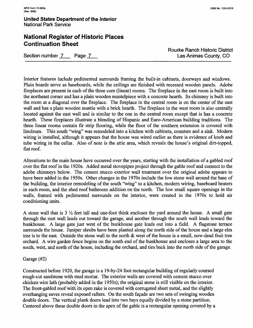
Interior features include pedimented surrounds framing the built-in cabinets, doorways and windows. Plain boards serve as baseboards, while the ceilings are finished with recessed wooden panels. Adobe fireplaces are present in each of the three core (linear) rooms. The fireplace in the east room is built into the northeast corner and has a plain wooden mantelpiece with a concrete hearth. Its chimney is built into the room at a diagonal over the fireplace. The fireplace in the central room is on the center of the east wall and has a plain wooden mantle with a brick hearth. The fireplace in the west room is also centrally located against the east wall and is similar to the one in the central room except that is has a concrete hearth. These fireplaces illustrate a blending of Hispanic and Euro-American building traditions. The three linear rooms contain fir strip flooring, while the floor of the southern extension is covered with linoleum. This south "wing" was remodeled into a kitchen with cabinets, counters and a sink. Modern wiring is installed, although it appears that the house was wired earlier as there is evidence of knob and tube wiring in the cellar. Also of note is the attic area, which reveals the house's original dirt-topped, flat roof.
Alterations to the main house have occurred over the years, starting with the installation of a gabled roof over the flat roof in the 1920s. Added metal stovepipes project through the gable roof and connect to the adobe chimneys below. The cement stucco exterior wall treatment over the original adobe appears to have been added in the 1950s. Other changes in the 1970s include the low stone wall around the base of the building, the interior remodeling of the south "wing" to a kitchen, modern wiring, baseboard heaters in each room, and the shed roof bathroom addition on the north. The low small square openings in the walls, framed with pedimented surrounds on the interior, were created in the 1970s to hold air conditioning units.
A stone wall that is 3 1A feet tall and one-foot think encloses the yard around the house. A small gate through the east wall leads out toward the garage, and another through the south wall leads toward the bunkhouse. A large gate just west of the bunkhouse gate leads out into a field. A flagstone terrace surrounds the house. Juniper shrubs have been planted along the north side of the house and a large elm tree is to the east. Outside the stone wall to the north & west of the house is a small, now-dead fruit tree orchard. A wire garden fence begins on the south end of the bunkhouse and encloses a large area to the south, west, and north of the house, including the orchard, and ties back into the north side of the garage.
Garage (#2)
Constructed before 1920, the garage is a 19-by-24 foot rectangular building of regularly coursed rough-cut sandstone with mud mortar. The exterior walls are covered with cement stucco over chicken wire lath (probably added in the 1950s); the original stone is still visible on the interior. The front-gabled roof with its open rake is covered with corrugated sheet metal, and the slightly overhanging eaves reveal exposed rafters. On the south fa9ade are two sets of swinging wooden double doors. The vertical plank doors lead into two bays equally divided by a stone partition. Centered above these double doors in the apex of the gable is a rectangular opening covered by a
NPS Form 10-900a OMB No. 1024-0018 (Rev. 8/86)
United States Department of the InteriorNational Park Service
National Register of Historic PlacesContinuation Sheet
Rourke Ranch Historic District Section number _7_ Page _8_ Las Animas County, CO
wood panel.
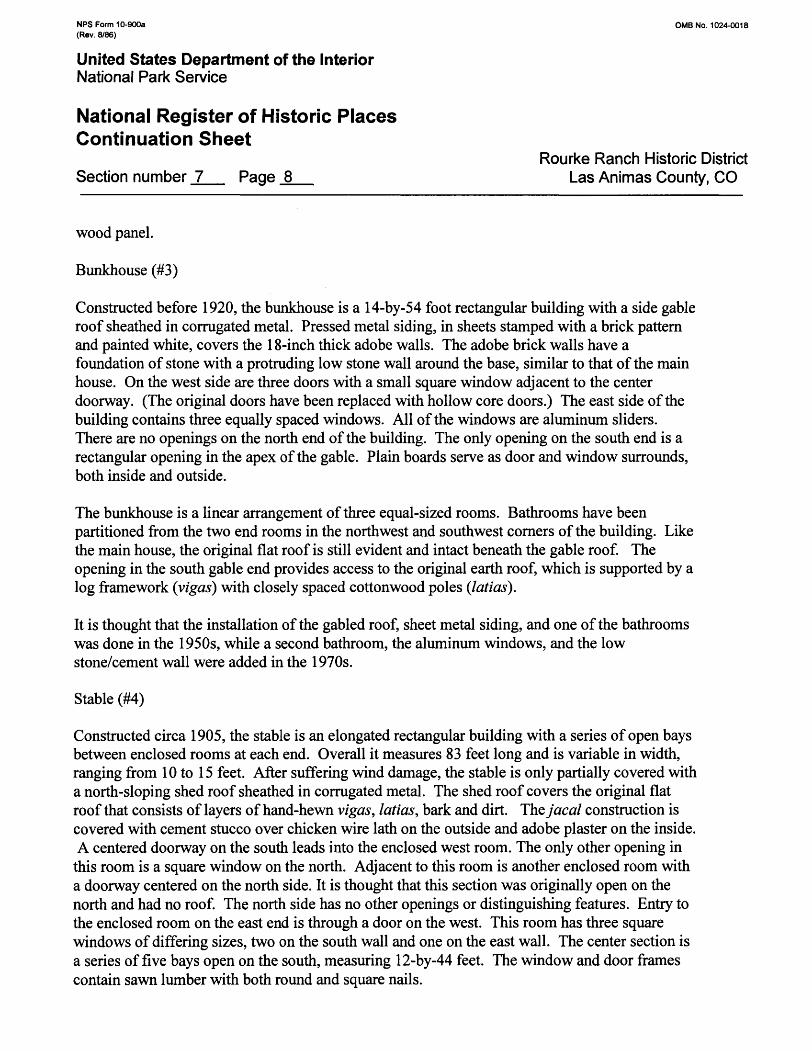
Bunkhouse (#3)
Constructed before 1920, the bunkhouse is a 14-by-54 foot rectangular building with a side gable roof sheathed in corrugated metal. Pressed metal siding, in sheets stamped with a brick pattern and painted white, covers the 18-inch thick adobe walls. The adobe brick walls have a foundation of stone with a protruding low stone wall around the base, similar to that of the main house. On the west side are three doors with a small square window adjacent to the center doorway. (The original doors have been replaced with hollow core doors.) The east side of the building contains three equally spaced windows. All of the windows are aluminum sliders. There are no openings on the north end of the building. The only opening on the south end is a rectangular opening in the apex of the gable. Plain boards serve as door and window surrounds, both inside and outside.
The bunkhouse is a linear arrangement of three equal-sized rooms. Bathrooms have been partitioned from the two end rooms in the northwest and southwest corners of the building. Like the main house, the original flat roof is still evident and intact beneath the gable roof. The opening in the south gable end provides access to the original earth roof, which is supported by a log framework (vigas) with closely spaced cottonwood poles (latias).
It is thought that the installation of the gabled roof, sheet metal siding, and one of the bathrooms was done in the 1950s, while a second bathroom, the aluminum windows, and the low stone/cement wall were added in the 1970s.
Stable (#4)
Constructed circa 1905, the stable is an elongated rectangular building with a series of open bays between enclosed rooms at each end. Overall it measures 83 feet long and is variable in width, ranging from 10 to 15 feet. After suffering wind damage, the stable is only partially covered with a north-sloping shed roof sheathed in corrugated metal. The shed roof covers the original flat roof that consists of layers of hand-hewn vigas, latias, bark and dirt. Theyaca/ construction is covered with cement stucco over chicken wire lath on the outside and adobe plaster on the inside. A centered doorway on the south leads into the enclosed west room. The only other opening in
this room is a square window on the north. Adjacent to this room is another enclosed room with a doorway centered on the north side. It is thought that this section was originally open on the north and had no roof. The north side has no other openings or distinguishing features. Entry to the enclosed room on the east end is through a door on the west. This room has three square windows of differing sizes, two on the south wall and one on the east wall. The center section is a series of five bays open on the south, measuring 12-by-44 feet. The window and door frames contain sawn lumber with both round and square nails.
NPS Form 10-900a OMB No. 1024-0018 (Rev. 8/86)
United States Department of the InteriorNational Park Service
National Register of Historic Places Continuation Sheet
Rourke Ranch Historic District Section number _7__ Page _9_ Las Animas County, CO
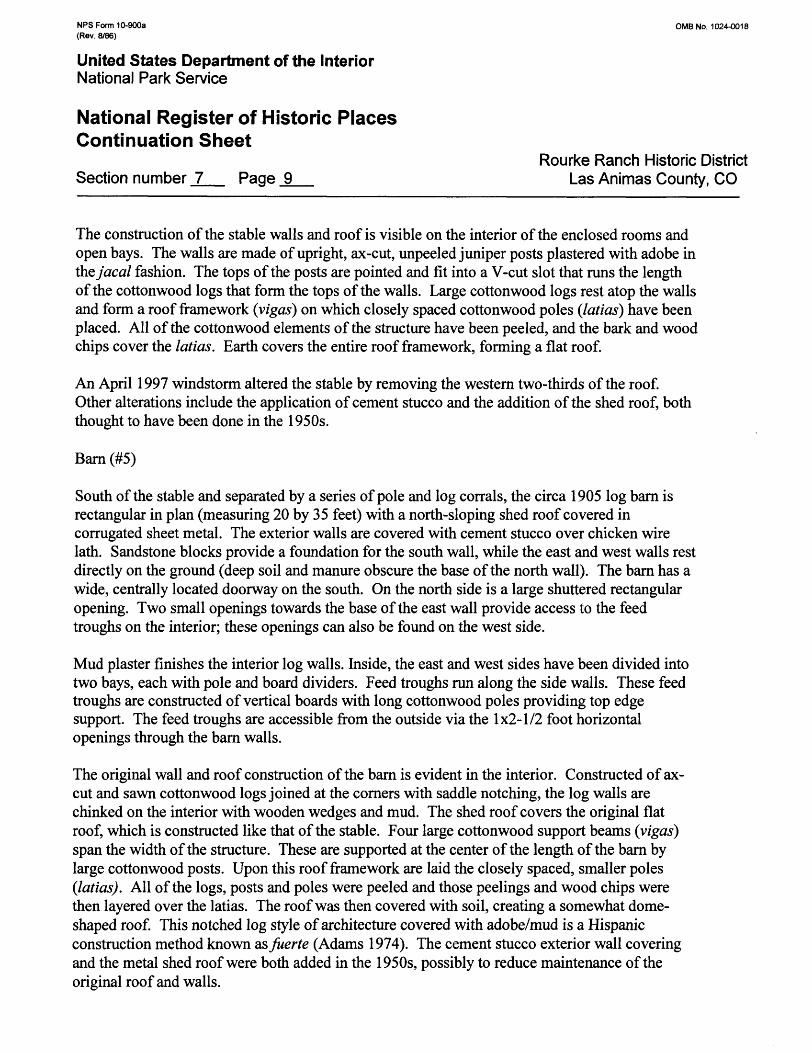
The construction of the stable walls and roof is visible on the interior of the enclosed rooms and open bays. The walls are made of upright, ax-cut, unpeeled juniper posts plastered with adobe in thzjacal fashion. The tops of the posts are pointed and fit into a V-cut slot that runs the length of the cottonwood logs that form the tops of the walls. Large cottonwood logs rest atop the walls and form a roof framework (vigas) on which closely spaced cottonwood poles (latias) have been placed. All of the cottonwood elements of the structure have been peeled, and the bark and wood chips cover the latias. Earth covers the entire roof framework, forming a flat roof.
An April 1997 windstorm altered the stable by removing the western two-thirds of the roof. Other alterations include the application of cement stucco and the addition of the shed roof, both thought to have been done in the 1950s.
Barn (#5)
South of the stable and separated by a series of pole and log corrals, the circa 1905 log barn is rectangular in plan (measuring 20 by 35 feet) with a north-sloping shed roof covered in corrugated sheet metal. The exterior walls are covered with cement stucco over chicken wire lath. Sandstone blocks provide a foundation for the south wall, while the east and west walls rest directly on the ground (deep soil and manure obscure the base of the north wall). The barn has a wide, centrally located doorway on the south. On the north side is a large shuttered rectangular opening. Two small openings towards the base of the east wall provide access to the feed troughs on the interior; these openings can also be found on the west side.
Mud plaster finishes the interior log walls. Inside, the east and west sides have been divided into two bays, each with pole and board dividers. Feed troughs run along the side walls. These feed troughs are constructed of vertical boards with long cottonwood poles providing top edge support. The feed troughs are accessible from the outside via the 1x2-1/2 foot horizontal openings through the barn walls.
The original wall and roof construction of the barn is evident in the interior. Constructed of ax- cut and sawn cottonwood logs joined at the corners with saddle notching, the log walls are chinked on the interior with wooden wedges and mud. The shed roof covers the original flat roof, which is constructed like that of the stable. Four large cottonwood support beams (vigas) span the width of the structure. These are supported at the center of the length of the barn by large cottonwood posts. Upon this roof framework are laid the closely spaced, smaller poles (latias). All of the logs, posts and poles were peeled and those peelings and wood chips were then layered over the latias. The roof was then covered with soil, creating a somewhat dome- shaped roof. This notched log style of architecture covered with adobe/mud is a Hispanic construction method known asfuerte (Adams 1974). The cement stucco exterior wall covering and the metal shed roof were both added in the 1950s, possibly to reduce maintenance of the original roof and walls.
NPS Form 10-900a OMB No. 1024-0018 (Rev. 8/86)
United States Department of the InteriorNational Park Service
National Register of Historic PlacesContinuation Sheet
Rourke Ranch Historic District Section number _7_ Page 10 Las Animas County, CO
Doghouse (#6)
Southwest of the bunkhouse is a circa 1910 doghouse that measures 2 l/2 by 7 1A feet. It is constructed of adobe bricks (2-1/2 by 5 by 9 inches) set upon a coursed sandstone slab foundation. The nine-inch thick adobe walls support a front gabled roof covered with corrugated sheet metal. The entry opening is on the south. The west wall of the doghouse has completely melted away, leaving only the east and north walls intact.
Hay Storage Structure (#7)
This ramada-like structure, approximately 22 by 38 feet, is south of the main house. The open- sided shelter has a sloping corrugated sheet metal roof. Ranging from 11 to 13 feet in height, the shed roof is supported by pole and post supports set in concrete. Inscribed in the concrete footing of one of the posts is "TA 1963". This probably indicates construction by ranch foreman Tony Aragon in 1963. A windstorm in April 1997 removed about two-thirds of the corrugated roofing. The roof joists have begun to sag due to the exposure to weather.
Storage Building (#8)
Immediately west of the barn is a 20-by-34 foot cinder block construction with a shed roof covered in corrugated metal. On the west side is a large opening with swinging double doors. The doors are wooden boards with cross bracing. A standard doorway on the south side is flanked by screened window openings. The floor is cement and there is a 10-by-20 foot cinderblock room in the northeast corner. Inscribed in the cement outside the south door is "1973/AUG/Tony Aragon". This inscription suggests that the ranch foreman, Tony Aragon, constructed the building in August of 1973.
New Feed Structure (#9)
Immediately east of the barn is an L-shaped cinderblock structure with a corrugated metal, north- sloping, shed roof that is entirely open on the south. A feed trough is along the north wall in the northwest corner. Juniper posts support the roof on the south edge. The similarity in construction to the storage building (#8) suggests that the feed structure was also built in the 1970s.
Small Wooden Framework (#10)
A small wooden framework which was used to support a gasoline storage tank is located northeast of the stable. It measures 6-by-l 1 feet and is constructed of six upright juniper posts
NPS Form 10-900a 0MB No. 1024-0018 (Rev. 8/86)
United States Department of the InteriorNational Park Service
National Register of Historic PlacesContinuation Sheet
Rourke Ranch Historic District Section number _7_ Page 11 Las Animas County, CO
onto which 2-by-6 inch boards have been nailed at a diagonal. Portions of a small metal gate have been attached for sides.
Original Eugene Rourke Homestead (5LA6400)
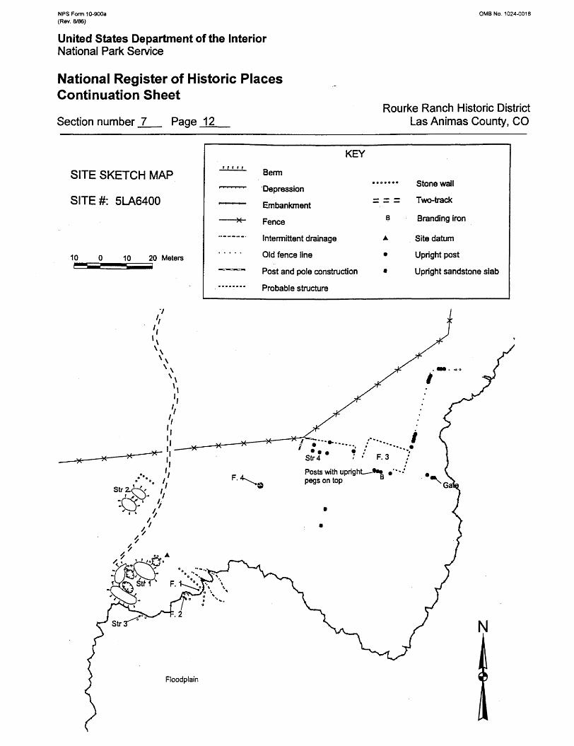
A historical archaeological site, 5LA6400, is the remains of a historic ranch complex located on the edge of the second terrace above the floodplain of the Purgatoire River. A portion of the residential part of the site has eroded away as a result of flooding in 1904. A two-track road enters the site from the north through a gate entry composed of two large juniper posts with barbed wire stretched above. The road ends about 100 feet from the gate at a large adobe mound that is the remains of a multi-room residence (Structure 1). The adobe mound is about 36 by 60 feet (east-west axis) and about 4 feet tall. The mound is covered with wolfberry. The most prominent feature of the adobe mound is a 20 by 20-foot depression, 3 feet deep, which represents a possible semi-subterranean room or a basement. A corner of sandstone rock is apparent on the northwest corner and stone rubble is evident along the perimeter. Three upright juniper posts are present in the western portion of the depression. The adobe mound to the west of the semi-subterranean room is filled with stone rubble and may contain another room. A considerable amount of adobe extends to the east as well. On the eastern edge of the mound is another visible room. This has sandstone block walls partly visible on the north and east sides that form a northeast corner. The east wall remnant is 10 feet long and the north is about 6 feet long. Two courses of stone are visible; the remainder is covered with adobe. Some window glass is also present in association with this room.
About 45 feet north-northwest of the residence is another patch of wolfberry that may be on a low mound of eroded adobe. No structural outline could be discerned, though a structure is certainly represented (Structure 2). In the northeastern portion of the area are some small sandstone blocks and one small foundation alignment that is 2 feet long (north to south). Probing indicated shallowly buried foundation stones in line with the visible foundation segment projecting in both directions, and there may be a northwest corner of a room indicated. Window glass is present just to the east of the possible room. Additional anomalous sandstone blocks and slabs are present elsewhere in the area.
About 10 feet southwest of the residence is another structure location represented by a 10- foot-long (east-west) section of a sandstone block wall in the floodplain cutbank (Structure 3). This wall is randomly coursed up to 10 courses high. Some rock is falling down slope and a possible northwest corner of the structure is present. About 95 percent of the structure is gone. One piece of burned bone was found in association with this structure.
NPSForm 10-900a (Rev. 8/86)
OMB No. 1024-0018
United States Department of the InteriorNational Park Service
National Register of Historic Places Continuation Sheet
Section number _7_ Page 12Rourke Ranch Historic District
Las Animas County, CO
SITE SKETCH MAP
SITE#: 5LA6400
10 0 10 20 Meters
KEY
Berm
Depression
Embankment
Fence
Intermittent drainage
Old fence line
Post and pole construction
Probable structure
Stone wall
Two-track
Branding iron
Site datum
Upright post
Upright sandstone slab
NPS Form 10-900a OMB No. 1024-0018 (Rev. 8/86)
United States Department of the InteriorNational Park Service
National Register of Historic PlacesContinuation Sheet
Rourke Ranch Historic District Section number _7_ Page 13 Las Animas County, CO
About 20 feet east of the southeast room of the residence is a 40-foot-long wall alignment (Feature 1), oriented east to west, almost in line with the north wall of the southeast room. The wall is made of sandstone blocks; four courses of masonry are visible where the wall is cut by the floodplain cutbank. About 20 feet west of the wall alignment, along the edge of the floodplain cutbank, are the remains of a stone-lined well (Feature 2). The southern portion of the well has been cut away by flooding. The well is a 3-foot-diameter semicircle of sandstone blocks standing 7 courses (3 1/2 feet) high.
About 160 feet northeast of the residence are the remains of a possible animal stable consisting of multiple open bays (Structure 4). The structure appears to have measured about 10 by 42 feet, oriented east to west. The structure was comprised of three 10-foot-wide bays on the west and one 12-foot-wide bay on the east, all open to the south. The north wall of the structure was built of large notched cottonwood logs. Upright juniper posts define the bay side walls. Some square nails, bolts, and railroad spikes are evident in the construction. The structure may have extended an additional 16 feet farther east to a 6-foot long north-south section of juniper post fence. The intervening area between the structure and the fence may contain melted adobe from an adobe room.
About 50 feet south of the post fence on the east end of the animal enclosure is a dressed, square sandstone block set on end in the ground. About 20 feet farther south is another upright square sandstone block set on end. Neither of these contain inscriptions, but have the appearance of grave stones, though they may both have been post supports for a fence line that is no longer apparent.
Another enclosure (Feature 3) is represented by an east-west row of juniper posts to the east of the possible animal stable. This alignment may be the remnants of a south wall of the structure. A mound of earth with shrubs growing on it may mark the location of a possible north wall. The enclosure may have been as large as 30 by 50 feet, oriented east to west. The northeast corner of the enclosure appears to coincide with the south end of a juniper post fence. Three juniper posts along the south wall have been cut down on top to form tenons, presumably for a mortised crosspiece. Two of the posts have been adzed flat on the north side; one has a hinge fragment attached. Adjacent is the remains of a board door held together with wire nails. A hinge is present, attached with square clinch nails. Evidently an enclosed room was present. A branding iron was collected immediately south of the upright posts. Aqua and purple square-paneled bottle fragments are present 10 feet to the west of the three juniper posts at the animal enclosure. In the eastern portion of the enclosure area are several standing and fallen juniper posts, some with forked ends. One large post has a strap hinge attached. Along the presumed east end of the enclosure area is a fallen juniper post with hinges attached. Some chicken wire is present in the northeast corner of the area. Perhaps the enclosure was several animal pens with various entries. It appears to have been constructed later than the animal enclosure to the west.
Farther east, in line with the front of the eastern enclosure, are more juniper posts and the remains of a possible gate at the edge of the floodplain cutbank. From the northeast corner of the eastern enclosure, a juniper post fence for a corral heads north for about 100 feet. The fence then turns east for about 25 feet, ending near a pile of rock. Much of the fencing has fallen over or is gone. The eastern portion of a
NPS Form 10-900a 0MB No. 1024-0018 (Rev. 8/86)
United States Department of the InteriorNational Park Service
National Register of Historic PlacesContinuation Sheet
Rourke Ranch Historic District Section number _7_ Page 14 Las Animas County, CO
fenced enclosure may have been washed away; there are some remnants on the top of the cutbank. About 30 feet southwest of the western animal enclosure is a wooden framework made of 2 by 10-inch planks bolted to 3 by 8-inch side rails. Crosspieces are bolted on top to mount an iron reinforced 2 by 3- inch board with iron brackets attached to one end. The brackets appear to be from a wagon tongue.
5LA6400 graphically demonstrates the devastation of the 1904 flood. Few artifacts are evident on the site surface; structural remains exist as rubble, adobe melt, and wooden posts. Adobe melt has certainly buried artifacts in and around the structure locations, and artifacts are very likely shallowly buried at other locations at the site as well. The layout of the ranch can be discerned and comparisons with Hispanic ranches from the same time period, located nearby, can be made. This may be useful in furthering an understanding of cultural interaction and assimilation. Although not demonstrated, the site likely contains substantial archaeological deposits that may provide important information about the early Rourke Ranch enterprise and interactions with the local Hispanic community.
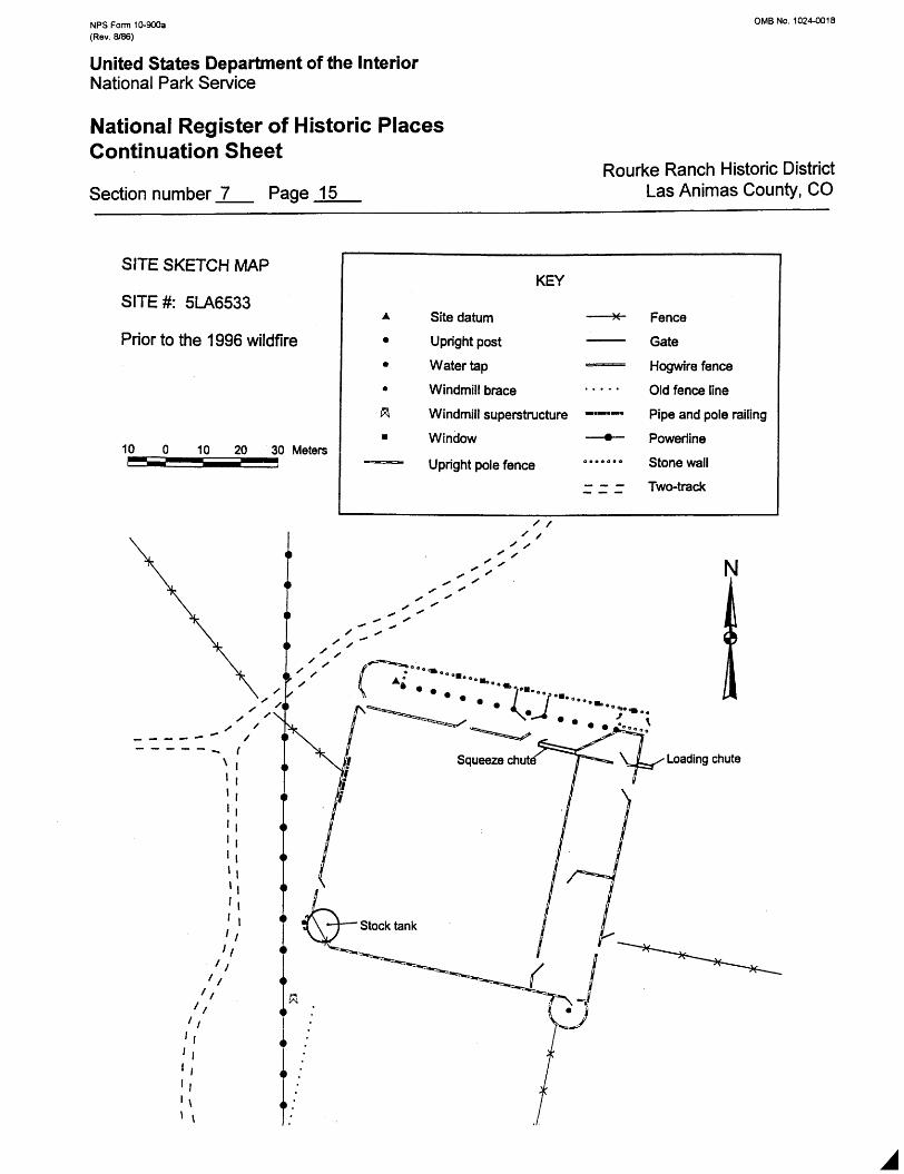
Stone Shed and Corral Complex (5LA6533)
The largest structure on the ranch, the shed and corral do not appear on the 1908 map, but were present in a 1940 aerial photograph. A Cheyenne Indian named Van Johnson, who worked for Harry Rourke, reportedly built the stone shed in about 1925. The shed was used for keeping weak or sick cattle during inclement weather (Sabin 1992). The aerial photo shows the corrals to be several yards away from the stone calf shed; they are presently located adjacent to the south of the shed.
The complex is located on the second terrace north of the Purgatoire River. It consists of an elongated stone calving shed on the north side of a large corral. The stone structure is 190 feet long and 12 feet wide with a corrugated sheet metal shed roof that slopes northward. The walls of the structure are constructed of wet-laid, rough-cut irregularly coursed sandstone blocks and slabs. There are seven small window openings at regular intervals along the north wall; all are framed with sawn lumber suggesting that they may have contained glass at one time. Large juniper posts are set at 12-foot intervals, forming 14 open bays along the south side. These are notched at the top to accept juniper cross beams, which are also notched on the ends and are bolted in place. Cottonwood pole roof supports extend from the crosspieces to the top of the back (north) wall every 2/2 feet. These are held in place on the top of the north wall by pieces of barbed wire looped around and anchored into the stone masonry. This same anchoring method has been used to hold the top beam on the west end of the structure. The roof poles are squared on the south end to fit the crosspiece to which they are bolted. Four rows of sawn boards run the length of the building on top of the roof poles, to which galvanized sheet metal is nailed. An enclosed 12 by 20-foot stone room is located on the east end. The stone room has doorways through the centers of the east and west elevations and window openings through the center of the north elevation. One bay has been enclosed with pole and board fencing.
NPS Form 10-900a (Rev. 8/86)
0MB No. 1024-0018
United States Department of the InteriorNational Park Service
National Register of Historic Places Continuation Sheet
Section number _7_ Page 15Rourke Ranch Historic District
Las Animas County, CO
SITE SKETCH MAP
SITE#: 5LA6533
Prior to the 1996 wildfire
10
KEY
Site datum
Upright post
Water tap
Windmill brace
Windmill superstructure
Window
Upright pole fence
Fence
Gate
Hogwire fence
Old fence line
Pipe and pole railing
Poweriine
Stone wall
Two-track
J-»..•. *"7, VjL^x Loading chuteT^
NPS Form 10-900a (Rev. 8/86)
0MB No. 1024-0018
United States Department of the InteriorNational Park Service
National Register of Historic Places Continuation Sheet
Section number _7_ Page 16Rourke Ranch Historic District
Las Animas County, CO
SITE SKETCH MAP
SITE#: 5LA6533
After the 1996 wildfire
10 10 20 Meters
KEY
Site datum
Upright post
Water tap
Windmill brace
Windmill superstructure
Window
Upright pole fence
Fence
Gate
Hogwire fence
Old fence line
Pipe and pole railing
Powerline
Stone wall
Two-track
Loading chute
Stock tank
I •
NPS Form 10-900a 0MB No. 1024-0018 (Rev. 8/86)
United States Department of the InteriorNational Park Service
National Register of Historic PlacesContinuation Sheet
Rourke Ranch Historic District Section number _7_ Page 17 Las Animas County, CO
The area directly south of the stone shed is enclosed as a separate area from the corral by fencing (see site sketch map). A section offence extends westward from the northwest corner of the shed for 20 feet, where it turns south for 14 feet to a gate. The gate is 13!/2 feet wide. The fence then extends another 3/4 feet to the northwest corner of the corral. The fence in this area is constructed from closely spaced juniper posts with an iron pipe wired onto the outside for support. The enclosure runs across the entire length of the open bays, angling to the southwest corner of the enclosed room on the east end. This forms a 20-foot-wide area in front of the bays. The easternmost five bays could be separated from the rest by closing a double gate.
An irregularly shaped enclosure is present south of the enclosed stone room on the east end of the stone shed. It is formed by the north corral fence, the angled main enclosure fence, a fence extending south from the southeast corner of the stone room, and a horizontal pole and board fence 3/4 feet out from and parallel to the south wall of the enclosed room. A loading chute extends eastward from the southeast corner of this irregular enclosure, elevated for loading or unloading animals into or from a truck. The loading chute is 15 feet long and 4 feet wide. It is made of 4 by 12-inch planks nailed on the inside of a pole framework. A large gate opens into the main corral to the south. The west end of the irregular enclosure narrows into a cattle chute with a metal gate. The chute is 3 feet wide and 34 feet long. It is made of 2 by 6-inch horizontal planks nailed on the inside of juniper and square timber posts. The chute probably was used to get cattle into a squeeze for branding and vaccinating. A board and metal door on the south side of the west end of the chute opens into the main corral. An opening in the north wall of the corral is located at the end of the chute. This opening is 14 feet wide and has a metal gate on the west side. The intervening space probably held the squeeze. The remainder of the north corral fence is a heavy gauge mesh wire fence on juniper pole posts. Juniper poles have been wired crosswise on the fence. Board gates are at the center of this fence and at the west end, both opening into the bay enclosure.
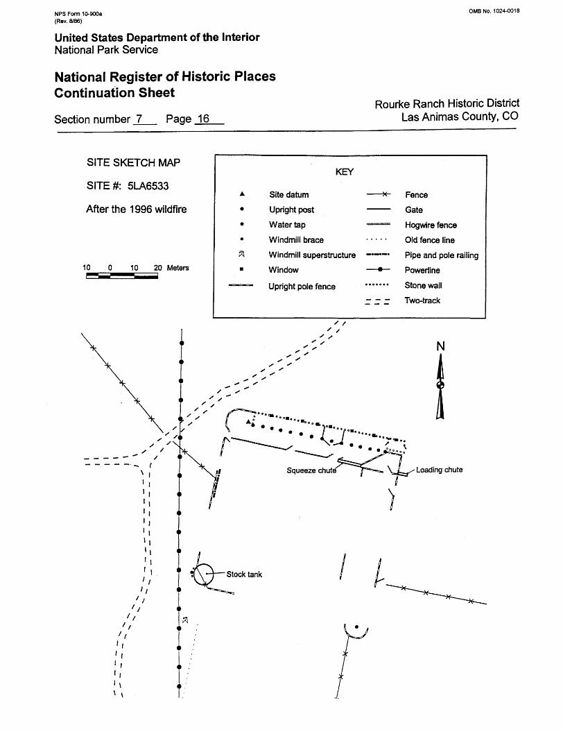
A wildfire in the Purgatoire River Valley destroyed about 75 percent of the large corral south of the stone stable in early April 1996 (see two site sketch maps illustrating before and after the fire). Remnants of the wooden corral fences remain and fence alignments can be discerned, but the layout is no longer easily deduced. The following description was made in 1994, when the corral was almost completely intact. The entire corral area measures 210 by 180 feet, oriented north to south. The main corral is 170 by 180 feet, oriented north to south, with two smaller enclosures on the east side, each measuring 40 by 90 feet. Most of the fencing consists of upright juniper posts with pipe reinforcement wired onto the outside. Besides the northern gates into the main corral, another 10-foot-wide gate is located on the south end of the west side that opens to the outside of the corral. Other gates include a 10-foot-wide gate on the north end of the east fence and an 8!/2-foot-wide gate on the south end of the east fence; these open into two smaller pens. A 10-foot-wide gate opens between the two smaller pens. A 9 1/2-foot-wide gate is also present through the center of the east fence of the southern smaller pen, and a 10-foot-wide gate is present through the north end of the east wall of the northern smaller pen. Both open to the outside. A 7-foot-wide gate opens into the irregularly shaped enclosure north of the northern small pen. A circular enclosure, about 32 feet in diameter, is located on the south end of the southern
NPS Form 10-900a OMB No. 1024-0018 (Rev. 8/86)
United States Department of the InteriorNational Park Service
National Register of Historic PlacesContinuation Sheet
Rourke Ranch Historic District Section number _7_ Page 18 Las Animas County, CO
small pen. It is made of the same upright juniper post construction and has a juniper post at the center. The circular enclosure was used to break horses (Sabin 1992).
At the southwest corner of the main corral is a metal stock tank lined with concrete, with an outlet pipe to the south. This is 20 feet in diameter and 1 foot deep. A frost-free faucet is on the west side of the stock tank. Two leg supports for a windmill are adjacent. The remainder of the windmill support has been discarded to the south. Evidently a windmill pump supplied the stock pond before the frost-free faucet was installed. Iron pipe, barbed wire, and woven wire fence cuts the corner of the corral diagonally across the tank.
A windstorm tore off a 66-foot-long section of the center of the roof in May 1998. The section of roof has been replaced with new 1 by 12-inch boards and corrugated sheet metal that matches the original construction.
NPS Form 10-900a OMB No. 1024-0018 (Rev. 8/86)
United States Department of the InteriorNational Park Service
National Register of Historic PlacesContinuation Sheet
Rourke Ranch Historic District Section number _7_ Page 19 Las Animas County, CO
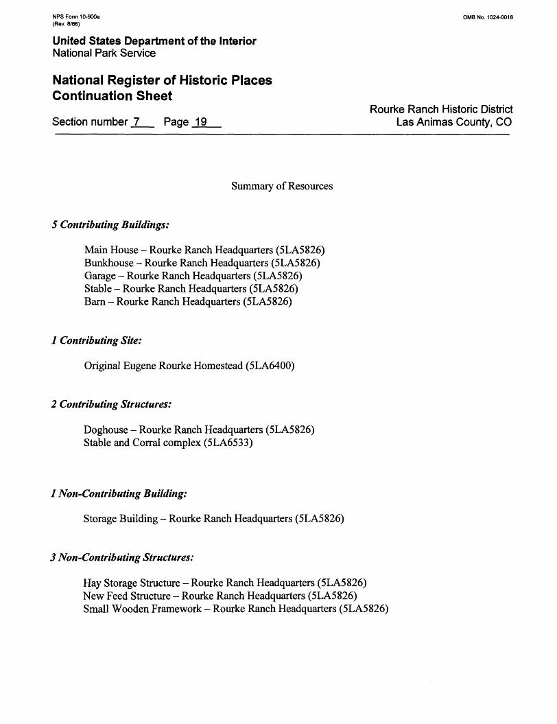
Summary of Resources
5 Contributing Buildings:
Main House - Rourke Ranch Headquarters (5LA5826) Bunkhouse - Rourke Ranch Headquarters (5LA5826) Garage - Rourke Ranch Headquarters (5LA5826) Stable - Rourke Ranch Headquarters (5LA5826) Barn - Rourke Ranch Headquarters (5LA5826)
1 Contributing Site:
Original Eugene Rourke Homestead (5LA6400)
2 Contributing Structures:
Doghouse - Rourke Ranch Headquarters (5LA5826) Stable and Corral complex (5LA6533)
/ Non-Contributing Building:
Storage Building - Rourke Ranch Headquarters (5LA5826)
3 Non-Contributing Structures:
Hay Storage Structure - Rourke Ranch Headquarters (5LA5826) New Feed Structure - Rourke Ranch Headquarters (5LA5826) Small Wooden Framework - Rourke Ranch Headquarters (5LA5826)
NFS Form 10-900a OMB No. 1024-0018 (Rev. 8/86)
United States Department of the InteriorNational Park Service
National Register of Historic PlacesContinuation Sheet
Rourke Ranch Historic District Section number _8_ Page 20 Las Animas County, CO
SIGNIFICANCE STATEMENT
The Rourke Ranch Historic District is eligible for the National Register under criterion A in the areas of Agriculture and Settlement. It is historically significant for its association with the settlement of the Purgatoire River area by sheep and cattle ranchers. The property reflects the interaction of Hispanic and Euro-American settlers and the resulting change in demographics and land ownership among the residents of the Purgatoire River valley. The aggregation of land by the Rourke family was a result of land use, demographics, interaction of ethnic groups, and the economics of western ranching. The acquisition of vast land holdings by successful ranchers and the failure of smaller landholders was a common occurrence in the arid west, and was an important trend in western settlement. The original ranch site (5LA6400) established by 1875 was the focal point of Eugene Rourke's ranching activity prior to the flood of 1904. Now an historical archaeological site, it represents initial settlement in the area. During that time Rourke began his land acquisitions, primarily from departing Hispanic settlers, that would eventually culminate in one of the largest ranches in the area. The ranchstead was moved about a half-mile northeast after the 1904 flood to what is known as the Rourke Ranch Headquarters (5LA5826) and the ranch continued to grow. The ranch headquarters is an excellent example of an aggregated ranchstead from the early 1900s in an arid and remote setting. The circa 1925 stone stable and associated corral (5LA6533) were an integral part of the Rourke ranching operations and reflect the expansion of the ranching enterprise by later generations of the Rourke family. The Rourkes were the longest-tenured and most persistent ranchers in the region. Founded by an Irish immigrant, the ranch expanded to become one of the most prosperous in the area. Although family members continued to own, manage, and increase the acreage of the ranch until it was sold in 1971, the period of significance ends in 1948, when Eugene Rourke's grandson assumed management of the property and tenants occupied the ranchstead.
The property is also eligible for the National Register under criterion C for its architectural significance. The buildings at the ranch headquarters (5LA5826) together with the stone corral (5LA6533) are an
excellent example of an early 1900s ranchstead in an arid and remote setting. The architecture of the headquarters also reflects the interaction between Hispanos and Euro-Americans. The main house is an excellent example of Territorial Adobe illustrating the blending of Hispanic and Euro-American building traditions. The ranch headquarters contains several good examples of southwestern vernacular architecture. The outbuildings represent several construction materials and methods, includingy'aca/, fuerte, and stone. The variety of building materials is characteristic of Hispanic building complexes, which typically utilized specific types of materials for different structures. The architectural significance of Rourke Ranch goes beyond the wide variety of vernacular construction techniques. Its Hispanic- influenced architecture and the stylistic details make the Rourke Ranch architecturally distinctive within the Picketwire Canyonlands.
NPS Form 10-900a OMB No. 1024-0018 (Rev. 8/86)
United States Department of the InteriorNational Park Service
National Register of Historic PlacesContinuation Sheet
Rourke Ranch Historic District Section number _8_ Page 21 Las Animas County, CO
Settlement and Agriculture
The land on which the Rourke Ranch is located was originally part of the Vigil and St. Vrain Land Grant. In an effort to reinforce Mexican claims to what is now Colorado, Governor Manuel Armijo of New Mexico made five land grants to attract settlers. The 1843 grant to Cornelio Vigil and Ceran St. Vrain covered four million acres. This grant stretched past the Purgatoire River on the south and east, roughly followed the Arkansas and Huerfano rivers on the north, and extended to the Sangre de Cristo Mountains on the West. St. Vrain, a trapper and trader born a United States citizen in St. Louis, became a naturalized Mexican. Among the early settlers on the Vigil and St. Vrain Grant were William Bent, Thomas Boggs, James Beckwourth, Charles Autobees, Lucein Maxwell, Joseph Doyle, Kit Carson, and Felix St. Vrain. They built adobe towns such as Hardscrabble in 1840, Pueblo in 1842, and Greenhorn in 1846. These Mexican land grants suffered various fates after 1848 under the Treaty of Guadalupe Hidalgo, when Mexico surrendered the territory to the United States. Although the treaty guaranteed the property rights of Mexican settlers, much land was stripped away from the original owners. The Vigil and St. Vrain grant was reduced to less than 98,000 acres in an 1860 court decision that was upheld in 1898. "Within the grants, individual settlers struggled to keep smaller lots. Sometimes U.S. courts threw out their claims for lack of written proof of ownership, a formality more important under Anglo than Hispanic law" (Noel et al. 1993).
Settlement of the Purgatoire River Valley may have begun in the late 1850s and early 1860s by both Hispanics from New Mexico and Euro-Americans enticed to the region by the Colorado gold rush. However, evidence of these early settlers has yet to be found. According to Carrillo (1990:XVIII-27), former Comancheros and Ciboleros from the Plains, living in a near-aboriginal manner, may have taken up residence along the Purgatoire River prior to 1860. Conflicts with Native Americans on the Plains in the 1860s, resulted in the establishment of Fort Lyon at the mouth of the Purgatoire River in 1867. It appears that the Bent Canyon and Red Rock portions of the Purgatoire River began to be settled by Hispanics and Euro-Americans that same year.
Early settlers along Purgatoire River were largely Hispanics from northern New Mexico who lived near Trinidad for a while before moving down the river (Friedman 1985:32). The first settler in the Red Rocks area, just south of the Rourke Ranch, was a man named Climer in 1867, followed later in the year by Juan Cordova and Miguel Bravo. Cordova and his family settled at the mouth of Chacuaco Creek, and Bravo settled a mile upstream. The Cordova Plaza was apparently made up of Juan Cordova as patron and his extended family (Friedman 1985:31-32).
Apparently as a result or in anticipation of government surveys of the land beginning in the late 1860s and early 1870s, settlers began establishing residences on 160-acre parcels that they then took steps to acquire under the requirements of the Homestead Act of 1862. Many of the initial settlers had already resided on their claims for five years by the time they could officially file their paperwork in the early 1870s. Rather than wait an additional five years after filing their land claims, those who could afford to do so purchased their claims outright from the government (National Archives, Record Group 49, Final
NPS Form 10-900a OMB No. 1024-0018 (Rev. 8/86)
United States Department of the InteriorNational Park Service
National Register of Historic PlacesContinuation Sheet
Rourke Ranch Historic District Section number _8_ Page 22 Las Animas County, CO
Certificates 984, 995,1018,1549,1759, and 1819; Reed and Horn 1995).
It has been estimated that the population of the Red Rocks/Bent Canyon area was probably about 450 people in 1874. Only about 200 people remained by 1882 (Friedman 1985:36). After the initial movement into the valley beginning in the late 1860s and early 1870s by groups of Hispanics living in small communities, the requirements for acquiring land under the Homestead Act may have changed the pattern of settlement. Under the Homestead Act, anyone who wished to obtain 160 acres of government land was required to reside on his or her claim for five years and make the necessary improvements required by law. Although nearby plaza settlements may have served as focal points for Hispanic settlers to some degree, the residence requirement of the Homestead Act may have served to decentralize the Hispanic community and made them less cohesive cooperative units. Although rather dispersed, the Hispanics in the area maintained a close-knit local community that was tied to Trinidad, where supplies were occasionally obtained and produce was marketed (Reed and Horn 1995).
For Hispanic settlers attempting to operate subsistence farms and ranches, the burden of working the land in isolation in the harsh environment of the canyon may have been too great. Crop production along the Purgatoire River was not possible in many places because it was very difficult to transport water to agricultural fields in ditches. When ditches were built, it was frequently difficult to divert water into them, and the river often washed diversion structures away. Another problem was crop destruction due to frequent flooding of the river (Reed and Horn 1995).
It is likely that many of the subsistence farmers chose to sell their land soon after receiving title to it from the government, remaining on the land only long enough to satisfy the residency requirements. The exceptions to this pattern were individuals who had sufficient capital to go into the stock-raising business. Probably not coincidentally, these were also the same individuals who were able to purchase their land as Cash Entries rather than by gaining title through Homestead Entries. In the vicinity of the Rourke Ranch Historic District, these individuals were Juan Pedro Baca, Jose Casimero Romero, and Lorenzo Abeyta (Reed and Horn 1995).
Intimidation of the settlers by large cattle companies may have resulted in some of the early Hispanic settlers, particularly those engaged in subsistence farming or sheep ranching, to sell out. By the middle 1880s, only a small number of Hispanics owned land along the river, though a number continued to reside in the area and work as laborers. Beginning in the early 1880s, Eugene and James Rourke began acquiring the lands of their departing neighbors, eventually amassing the largest cattle ranch in the region. The Rourke Ranch was an important location in the canyon, serving as a stage stop, post office, and store from the late 1870s to the late 1890s (Reed and Horn 1995).
The difficulty of making a living farming and sheep ranching along the Purgatoire River probably forced most of the Hispanic settlers to reconsider what they were doing and sell their landholdings to one of the large ranches that were becoming established in the region. In the 1870s and early 1880s, the largest ranches in the region were owned by the Jones Brothers (cattle) and by Casimero Barela (sheep and
NPS Form 10-900a OMB No. 1024-0018 (Rev. 8/86)
United States Department of the InteriorNational Park Service
National Register of Historic PlacesContinuation Sheet
Rourke Ranch Historic District Section number _8_ Page 23 Las Animas County, CO
cattle). The Prairie Cattle Company purchased the holdings of the Jones Brothers in 1882, becoming for a time the largest cattle ranch in southeastern Colorado (Reed and Horn 1995).
Although the majority of early settlers in the Purgatoire River Valley were Hispanic farmers and sheep growers from northern New Mexico, some Euro-Americans also entered the area. Euro-Americans had a different approach to settlement than did the Hispanics. Euro-Americans appear to have taken up their claims with the expectation that they would start a small cattle operation and made no attempt to farm the land. Their ties were not to a local community, but rather to communities farther away, in most cases to the Jones Cattle Company and Prairie Cattle Company headquarters located at Higbee, several miles to the northeast. Some may have acquired land with the intention of selling it to one of the large cattle companies once they were assured title (Reed and Horn 1995; National Archives, Record Group 49, Cr. Book Vol. 1, Page 380, Cash Entry No. 1892; Las Animas County Courthouse, County Clerk's Office, Deed Book 8, Page 67). The impact of the large cattle companies on the largely Hispanic settlers was profound.
The Jones Cattle Company, also known as the JJ Ranch, Jones Ranch, or Jones Brothers Ranch, was one of the largest cattle ranches in Colorado in the 1870s and early 1880s. Three brothers—Peyton, James, and Steven Jones—owned the ranch. The Jones brothers were born in Tennessee and moved to Texas in 1850, where Peyton bought some cattle and went into the cattle business. After serving with the Confederacy during the Civil War, the brothers returned to Texas and went into the cattle business together. In 1869, they moved their operation to Bent County, Colorado, establishing their headquarters at Nine Mile Bottom on the Purgatoire River at what later became the town of Higbee. In 1875, James C. Jones traded his interest in a farm in Kansas for one of his brother's interest in a general store in West Las Animas. The Jones Cattle Company reportedly owned 8,000 to 10,000 acres of land and utilized a great deal of the public domain as free range for grazing. They gradually increased the size of their herd to 30,000 head of cattle and 250 horses by 1881 (Anonymous 1881:868-870; Kurd 1957:76-80). They were listed under West Las Animas through 1882 when they sold their holdings to the Prairie Cattle Company (Hurd 1957:80; Colorado State Business Directories, 1875-1882).
The Prairie Cattle Company was owned by the first consortium of foreign investors from Great Britain to invest in the cattle industry in the American West. The company was made up of investors from Scotland who were convinced of the soundness of investing in the American cattle industry by Underwood, Clark & Company of Kansas City. Underwood, Clark, & Company recommended that the syndicate purchase three large cattle ranches, one each in Colorado, New Mexico, and Texas. A critical element in their proposition was that, by purchasing the three companies, they would acquire tracts of land that encompassed important watercourses. This would result in their controlling a large quantity of the surrounding public domain that could then be used for grazing at no cost. In Colorado, the Prairie Cattle Company purchased the holdings of the Jones Brothers, including their famous JJ brand. Soon thereafter, they bought the Cross L Ranch in Colfax County, New Mexico, and the Littlefield Ranch, with their LIT brand, on the Canadian River in Texas. In all, the company purchased 125,000 head of cattle and 2,240,000 acres of land at a cost of $3,500,000. The Colorado ranch was considered to be the
NPS Form 10-900a 0MB No. 1024-0018 (Rev. 8/86)
United States Department of the InteriorNational Park Service
National Register of Historic Places Continuation Sheet
Rourke Ranch Historic District Section number _8_ Page 24 Las Animas County, CO
home ranch, and cattle were shipped from Las Animas and Granada. Despite difficulties in the cattle business in the middle 1880s, the Prairie Cattle Company operated at a profit for about 25 years. In 1912, the company began selling off its holdings, finally ceasing operations in 1917 (Hurd 1957:80-83; Clay 1961:129-139).
In the midst of Hispanic landholders, a few miles up the Purgatoire River from the headquarters of the large cattle companies, Eugene Rourke settled on a 160-acre Homestead in 1875 (National Archives, Record Group 49, Homestead Entry Patent No. 2017). His arrival marked the beginning of the longest tenure residency of any family in the area. Eugene Rourke was born March 17,1849 in County Wicklon, Ireland. He immigrated with his family to La Salle, Illinois three years later. Rourke came to Colorado in the 1860s to mine gold at Black Hawk and Central City (Sabin 1992; Anonymous n.d.). Rourke apparently visited the region in December 1869 and in 1871. Rourke and his bride returned to settle permanently in the Purgatoire River Valley in December 1875, and built a house at the confluence of Bent Canyon and the Purgatoire River. While the house was being completed, the Rourkes resided at the stage station at the head of Bent Canyon along the Mountain Branch of the Santa Fe Trail (Anonymous n.d.). James Rourke, Eugene's brother, settled nearby. Gradually the two Rourke brothers acquired a great deal of land and operated a ranch together as Rourke and Rourke (Friedman 1985:35- 36).
It is not known with certainty what kind of relationship Eugene and James Rourke had with most of their Hispanic neighbors, or with the Jones Cattle Company and Prairie Cattle Company. It does appear that Eugene had a close relationship with Damacio Lopez, who operated the post office and store for many years at the Rourke Ranch (Taylor 1964). In 1878, the Bent Canyon post office was moved to the Rourke Ranch, and Eugene Rourke became postmaster (Friedman 1985:36-7). The change appears to coincide with the completion of the Santa Fe Railroad and abandonment the stage station at the head of Bent Canyon, where the post office had formerly been located. Rourke shared the duties of postmaster with Damacio Lopez from 1878 to 1898 (Friedman 1985:34). During the same period, Lopez appears to have operated a store at the Rourke Ranch (Hudson 1987:42).
Damacio Lopez, also known as Jose Damacio Lopez, may have first visited the land he eventually settled upon near the mouth of Minnie Canyon, about 4 miles northeast of the Rourke Ranch, in 1867 (Lopez 1874). Lopez served in the army at Fort Union during the Civil War. He was discharged in 1865 and moved to Trinidad in about 1866 from Santa Cruz, New Mexico, near Espanola. He had married Loreta Perea DeArcia (De Arce) of Bernalillo prior to moving to Colorado. Loreta DeArcia was of French extraction. The Perea side of her family had arrived in New Mexico from Spain in 1780s and settled in a French community at Bernalillo where they raised sheep. After moving to Colorado, Damacio Lopez worked as a freighter along the Santa Fe Trail between Missouri and New Mexico, and may have worked at Bent's Fort. In 1871, Lopez and his family moved to the Purgatoire River Valley. Lorenzo Abeyta had settled in the area a few years before and encouraged settlers to move into the valley (Hudson 1987:1-4, 29). Lopez built an adobe residence during the summer of 1871 (Hudson 1987:30). In 1874, Lopez reported that he had built two dwelling houses, outbuildings, corrals, stables, and
NFS Form 10-900a 0MB No. 1024-0018 (Rev. 8/86)
United States Department of the InteriorNational Park Service
National Register of Historic PlacesContinuation Sheet
Rourke Ranch Historic District Section number _8_ Page 25 Las Animas County, CO
irrigation ditches on land he considered to be his near the mouth of Minnie Canyon (Lopez 1874). By 1885, Damacio Lopez had prospered by acquiring large herds of cattle. He had good horses for ranch and farm work and had depended upon the help of six sons for help in building up his ranch (Hudson 1987:42).
The Lopez family was very religious and built a chapel on their land that became a focal point of the local Hispanic community (Hudson 1987:9-11). The Lopezes were also very interested in providing an education for their children. Damacio Lopez donated land for a schoolhouse built on his land just up the canyon from their house. Lopez and his neighbors built a wood frame building and had enough money to hire a schoolteacher for five or six months of the year. The Lopez children learned to read and write in both Spanish and English. They also benefited from frequent visits from their neighbor, John Littleton, who was college educated and loaned books to the family (Hudson 1987:11-12, 34, 66, and 72). Damacio Lopez and his family moved from their ranch along the Purgatoire River to Rocky Ford in about 1903. They still raised cattle in the area and used the ranch buildings on occasion (Hudson 1987:72-74).
The Lopez family had the longest tenure of any Hispanic family in the valley. They were able to interact successfully with Euro-Americans in the area, such as the Rourkes, and appear to have escaped the wrath of the nearby cattle companies. Part of the reason they may have succeeded where other Hispanics did not may have been their more anglicized appearance. They were reported to have been blue-eyed and blonde-haired. In addition, their ability to speak both Spanish and English certainly eased their acceptance in both cultures. It is likely that the Rourke's association with the Lopez family facilitated their acquisition of land by departing Hispanics in the 1880s (Sabin 1992; Reed and Horn 1995).
The Rourkes may not have interacted socially with their Euro-American neighbors who were employed by the Prairie Cattle Company. William Withers, a foreman for the Prairie Cattle Company living about 5 miles northeast of Eugene Rourke, did not mention the Rourkes in a letter he wrote in 1887 describing the isolation of his homestead claim. In that letter Withers stated that, "[w]e have neighbors from 30 to 40 miles [away] and are placed now in between two Mexican settlements. No white family lives nearer than 8 or 9 miles, and it is very lonely for my wife to be so closely confined to the land." Mrs. Withers apparently was hopeful that "American" settlers would move nearby so she would not be so lonely (National Archives, Record Group 49, Cash Entry No. 4858). It may be surmised from this letter that the Withers and the Rourkes may not have been on friendly terms. It is also apparent that the Withers did not interact socially with their Hispanic neighbors (Reed and Horn 1995).
Conflict between the Hispanic settlers of the region and the large cattle companies had its origin with the Jones Cattle Company. That relationships with nearby Hispanic sheep ranchers were strained is illustrated by an altercation between Lorenzo Abeyta and cowboys from the JJ Ranch in which the cowboys mistakenly believed that they had killed Abeyta. As a reward, the cowboys were given some money and seven horses (Friedman 1985:57). During this period of conflict with the Jones Cattle Company, four early Hispanic settlers, Vicente Archibacca, Marselina Guiterez, Jose Candelaria, and
NPS Form 10-900a OMB No. 1024-0018 (Rev. 8/86)
United States Department of the InteriorNational Park Service
National Register of Historic Places Continuation Sheet
Rourke Ranch Historic District Section number _8_ Page 26 Las Animas County, CO
Miguel Griego, sold out to Eugene Rourke in 1880 (Las Animas County Courthouse, County Clerk's Office Deed Book 11, Pages 407-410). These were the first acquisitions of additional land made by Rourke (Reed and Horn 1995).
Following the sale of the Jones Cattle Company, relations between the new owners (the Prairie Cattle Company) and local sheep ranchers and settlers continued to deteriorate. In 1882, it was reported that 12 to 14 employees of the Prairie Cattle Company killed or injured 4,000 sheep owned by a Mr. Pearie grazing on the ranches of Lorenzo Abeyta, Antone Salas, and Juan Cordova. The sheep were chased 40 miles into New Mexico through Emery Gap, and houses, blankets, and provisions of the sheepherders were burned on the three ranches (Rocky Mountain News, February 17, 1882 p. 2 c. 5). Subsequent actions by the cattle company further demonstrated the ruthlessness of their activities in controlling the region. In 1885, it was reported that the federal government brought four charges against the Prairie Cattle Company for illegally fencing 10,000 acres of the public domain in the Purgatoire River area (Rocky Mountain News, January 28,1885, p. 6, c. 2 and August 12, 1885, p. 1, c. 1). It was also reported, in 1885, that the Prairie Cattle Company had been battling small cattle operations coming into their territory in New Mexico and that they had killed the foreman of one of the invading outfits (Rocky Mountain News, August 21,1885, p. 1, c. 1). Hurd (1957:82) also reports that settlers coming west who wanted to settle on the public domain came into conflict with the Prairie Cattle Company. It is possible that fear of the Prairie Cattle Company may have been the final impetus for most of the area's Hispanic settlers to sell or give up their claims (Reed and Horn 1995).
The raid by the Prairie Cattle Company in February 1882 seems to have been a major event in the area. Although the Rourkes seem to have lived in harmony with neighboring Hispanics, they also benefited by their departure by acquiring their land, thereby expanding their ranch holdings. In addition to the Rourke family and a few other Anglo-Americans, Casimero Barela also increased the size of his ranch. Barela was the only Hispanic rancher able to compete on an equal footing with the Prairie Cattle Company for a number of years in the early 1880s (Reed and Horn 1995). Barela was an economically and politically powerful individual. He was involved in the establishment of the town of Trinidad and the San Luis Valley Railroad, was the founder of the town of Barela where his ranch headquarters was located from 1881 to 1887, and had an extensive sheep and cattle operation. In 1885, the Secretary of Interior forced Barela to remove illegal fences from 38,000 acres of land in southeastern Colorado (Mehls and Carter 1984:64). Barela served as a state representative and senator throughout the 1870s to 1890s and held various elected positions in Las Animas County in the 1870s and 1880s (Hall 1895:383; Denver Tribune Republican January 5, 1893, p. 1-2; Stone 1918).
Drought and hard winters between 1885 and 1887 devastated the Plains livestock industry. Large numbers of the initial settlers abandoned their claims in the region at that time. In the Purgatoire River Valley area, however, most of the Hispanic settlers had already disposed of their holdings, so the harsh winters and summers had little affect on land ownership (Las Animas County Courthouse, County Treasurer's Office, 1884-1888 Tax Rolls). Land ownership remained relatively stable until the 1890s, when a resurgence of Hispanic land entries took place on previously unpatented land in the vicinity of
NPS Form 10-900a OMB No. 1024-0018 (Rev. 8/86)
United States Department of the InteriorNational Park Service
National Register of Historic PlacesContinuation Sheet
Rourke Ranch Historic District Section number _8_ Page 27 Las Animas County, CO
the Rock Crossing of the Purgatoire River, about 3 miles northeast of the Rourke Ranch. All of these individuals seem to have departed by the early 1900s (Las Animas County Courthouse, County Treasurers Office, 1890-1900 Tax Rolls).
The Purgatoire River flooded on September 30,1904, causing immense damage along its banks; it reportedly had a volume of 45,000 feet per second (Hudson 1987:iii). Because most of the early ranches along the river had been vacated by the middle 1880s, the Rourke Ranch seems to have been the only active ranch that was impacted. Damage to this ranchstead resulted in moving the headquarters to higher ground, about 0.6 miles to the northeast, where the Rourke Ranch Headquarters complex still stands today. Evidence of the damage to the original ranchstead can still be discerned.
The extent and effect of the flood on the Hispanic community is difficult to assess. Clearly, the flood destroyed many of the early ranches along the Purgatoire River, but these had been vacated years before. By 1904, the Hispanic community in the vicinity of Minnie Canyon and the Rock Crossing may have
been quite reduced in size and not particularly viable. The Bent Canyon post office had been terminated in 1902 and Damacio Lopez and his family had moved to Rocky Ford in about 1903 (Hudson 1987:42). A few residences seem to have existed at the Rock Crossing of the river that may have been impacted by the flood.
Eugene Rourke moved from the ranch to La Junta in 1898 and began construction of a two-story brick residence (listed in the National Register), which combined Late Victorian and Colonial elements. The Rourke family, which included ten children, moved to La Junta because of the school system (Keck 1982). Eugene's brother, James, died about the same time. After moving to La Junta, the ranch was managed by his sons E. H. (Harry) and John.
The 1904 flood of the Purgatoire River swept away their original home in Bent Canyon, forcing the family to relocate the ranch headquarters. Presumably, the Rourkes began erecting the new ranchstead very soon after the flood, although they did not apply for a patent on the land until 1908. In that year Eugene's wife, Mary Elizabeth Rourke, entered an application for a claim under the Desert Land Act. This act allowed claims of up to 640 acres for an initial cost of 25 cents an acre. The homesteader was required to irrigate a section of the claim, and after three years the property could be purchased for an additional one dollar an acre. The patent on the land was approved on March 9, 1915. This was three years longer than it normally took because government land office investigators were not able to get to the homestead and verify that the land was indeed irrigated (HABS No. CO-91).
Upon Eugene Rourke's death in 1918, his son, Harry Rourke, and daughter, Frances Mary Rourke, bought the rights of the other family members and continued operating the ranch together. After the death of Harry Rourke in 1929, Frances Rourke managed the ranch through the 1930s and into the 1940s (Anonymous n.d.). Rourke family members made several land acquisitions in the 1910s and 1920s adjacent to the original holdings of Eugene and James Rourke that increased the size of the Rourke Ranch (Reed and Horn 1995). Additional dry-land farming ventures were attempted on the uplands,
NFS Form 10-900a OMB No. 1024-0018 (Rev. 8/86)
United States Department of the InteriorNational Park Service
National Register of Historic PlacesContinuation Sheet
Rourke Ranch Historic District Section number _8_ Page 28 Las Animas County, CO
away from the Purgatoire Valley on land that had previously been considered to be unproductive. These were made possible by the enactment of the Enlarged Homestead Act of 1909; all were rather short lived. Prices for agricultural products began to drop in the early 1920s, and drought in the middle 1920s led the majority of new settlers to abandon their claims or sell them to neighboring ranchers beginning in 1924. The Depression of the 1930s caused severe economic problems for ranchers of the area, causing many to fail. Those who survived, like the Rourkes, were able to acquire the holdings of the failed ranches at low cost, enabling their ranches to continue to grow in size. By 1940, the Rourke Ranch had grown to 35,000 acres. Eugene Rourke's grandson, Robert Sabin, assumed management of the ranch in 1948 and increased the acreage to 52,000, with another 25,000 acres leased from the Comanche National Grassland. Sabin did not live on the ranch, but had three ranch hands and their families living there. The Rourke family sold the ranch in 1971. The eastern portion of the ranch, including the ranch headquarters, was sold to the Stineman family (Friedman 1985:73-86). In 1984, the United States Army acquired the property. In 1991, the property was transferred from the Department of Defense to the Department of Agriculture, becoming a part of the Comanche National Grassland.
The history of the Rourke family mirrors the history of cattle ranching in southeastern Colorado. The family realized from the outset that stock raising was one of the few sustainable occupations in this semi-arid region of Colorado. They only raised cattle, and their ranch was know locally as the Wineglass Ranch because of their brand (HABS No. CO-91). Beginning with 40 acres, the Rourke family expanded their ranch to over 50,000 acres by the 1950s. They effected the increase in their land holdings by having family members apply for patents using various homesteading acts and also by buying from failed homesteaders in the late 19 and early 20 centuries. The Rourkes typified large cattle operations in southeastern Colorado, yet atypically remained in the area for almost 100 years (HABS No. CO-91).
Architecture
The architecture of the Rourke Ranch Headquarters is physical evidence of the interactions between Hispanics and Euro-Americans. The buildings of the Rourke Ranch headquarters were constructed in a Hispanic architectural tradition, although Eugene Rourke was Irish and his wife was from Illinois. Rourke, like many of his Euro-American neighbors, no doubt relied on local Hispanic labor and expertise to construct his ranchstead. This is a reflection of the demographics of the area beginning in the 1870s. According to Friedman (1989:39,60), in 1880, 67 percent of the farm owners in the general area were Anglo-Americans, whereas 100 percent of the farm laborers were Hispanic. In the Purgatoire River valley in the immediate vicinity of the Rourke Ranch, the percentage of Hispanic landowners was closer to 90 percent prior to 1885 and only about 20 percent by 1900 (Reed and Horn 1995). By 1900, the majority of the area's Hispanic population was employed as migrant workers on Anglo-owned ranches.
NFS Form 10-900a OMB No. 1024-0018 (Rev. 8/86)
United States Department of the InteriorNational Park Service
National Register of Historic PlacesContinuation Sheet
Rourke Ranch Historic District Section number _8_ Page 29 Las Animas County, CO
The Rourke ranchstead possesses characteristics of northern New Mexico vernacular architecture, evident in the original linear floor plan, adobe residential construction with portals (long covered porches) and parabola-shaped fireplace openings; and the outbuildings ofjacal orfuerte (log) with flat roofs. Bunting notes (1976) that even when logs were abundant in the mountains of northern New Mexico, adobe was preferred for dwellings and timber was only used for service structures such as barns, corrals, shelters, and storage sheds. The Rourke ranchstead illustrates this pattern of using different materials for different types of buildings. Hispanos from New Mexico were the first to utilize adobe andjacal construction in the Bent Canyon area, and while Anglos seldom built with adobe, there are several residences in the area built of adobe. It is apparent that the Anglo homesteaders, recognizing the superior durability and insulation qualities of adobe, adopted this Hispanic technique. While log construction is usually associated with elevations in excess of 7,000 feet, it is interesting to note that there were log buildings all along the Purgatoire River. The barn and stable at the Rourke ranchstead are unusually good examples of vernacular Hispanic construction utilizing logs. The notched log construction of the barn is a common Anglo and Hispanic building technique, known asfuerte in Hispanic nomenclature. The logs of the barn have their bark and cambium removed in typical Hispanic fashion. Thejacal construction technique (i.e., vertical posts plastered with mud to form walls) used in the stables is a Hispanic and Native American building method characteristic of the Southwest. Further evidence of Hispanic influence in the construction of the barn and stable are the earthen roofs placed on layers of bark and wood chips over closely spaced cottonwood poles (latias).
The main residence is a good example of Territorial Adobe architecture, which combines elements of Hispanic and Anglo buildings traditions. The original flat roof, the linear arrangement of the three rooms forming the core of the house, and the adobe fireplaces (most notably the corner fireplace) are typical elements of Hispanic Adobe construction. The pedimented window (with shutters) and door openings reflect the introduction of European building elements. The subsequent addition of the gabled roof and the stuccoed covered adobe walls, while facilitating maintenance, were also "introduced" elements and typical of the Territorial style. The adobe bunkhouse is of similar construction with its linear floor plan and a later gabled roof installed over the original flat roof.
The buildings on the Rourke ranchstead reflect the prosperity of their stock raising operation. The residence and bunkhouse, constructed of adobe, consumed more time to build than the structures ofjacal or stone. The logs, used in the construction of the barn, were a relatively uncommon local building material and had to be hauled from at least a mile away. The Rourke's prosperity is also reflected in the details of the buildings they erected. The main house has evidence of fine woodworking in the paneled wood ceiling; the pedimented doors and windows; and the built-in cabinets with custom-made frames and doors. The Rourke Ranch is significant not only for the wide variety of vernacular construction techniques, but also for its Hispanic-influenced architecture and the stylistic detailing, which is not found in other Bent Canyon area properties.
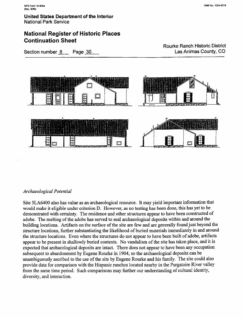
NFS Form 10-900a (Rev. 8/86)
OMB No. 1024-0018
United States Department of the InteriorNational Park Service
National Register of Historic Places Continuation Sheet
Section number _8_ Page 30Rourke Ranch Historic District
Las Animas County, CO
Archaeological Potential
Site 5LA6400 also has value as an archaeological resource. It may yield important information that would make it eligible under criterion D. However, as no testing has been done, this has yet to be demonstrated with certainly. The residence and other structures appear to have been constructed of adobe. The melting of the adobe has served to seal archaeological deposits within and around the building locations. Artifacts on the surface of the site are few and are generally found just beyond the structure locations, further substantiating the likelihood of buried materials immediately in and around the structure locations. Even where the structures do not appear to have been built of adobe, artifacts appear to be present in shallowly buried contexts. No vandalism of the site has taken place, and it is expected that archaeological deposits are intact. There does not appear to have been any occupation subsequent to abandonment by Eugene Rourke in 1904, so the archaeological deposits can be unambiguously ascribed to the use of the site by Eugene Rourke and his family. The site could also provide data for comparison with the Hispanic ranches located nearby in the Purgatoire River valley from the same time period. Such comparisons may further our understanding of cultural identity, diversity, and interaction.
NPS Form 10-900a OMB No. 1024-0018 (Rev. 8/86)
United States Department of the InteriorNational Park Service
National Register of Historic PlacesContinuation Sheet
Rourke Ranch Historic District Section number _9_ Page _31_ Las Animas County, CO
BIBLIOGRAPHY
Adams, Robert H.1974 The Architecture and Art of Early Hispanic Colorado. Colorado Associated University
Press, Boulder.
Anonymous1881 History of the Arkansas Valley, Colorado. O. L. Baskin & Co., Historical Publishers,
Chicago.
Anonymousn.d. The Rourke Ranch. Typed manuscript included with Record of the Bent County Stock
Association. On file at the Comanche National Grassland Headquarters, La Junta, Colorado.
Bunting, Bainbridge1976 Early Architecture in New Mexico. University of New Mexico Press, Albuquerque.
Carrillo, Richard F.1990 Historic Overview. In: An Introduction to the Archaeology ofPinon Canyon,
Southeastern Colorado, Volume 3: Ethnohistory and History, edited by W. Andrefsky, pp. XVII-1-45. Larson-Tibesar Associates, Inc., Laramie, Wyoming, and Centennial Archaeology, Inc., Ft. Collins, Colorado. On file at the U.S. Forest Service, Comanche National Grassland Headquarters, La Junta, CO.
Clay, John1961 My Life on the Range. Antiquarian Press, Ltd., New York.
Colorado State Business Directories, 1875-1882. On file at the Denver Public Library, Western History Collection.
Denver (Colorado) Tribune Republican 5 January 1893
Friedman, Paul D.1985 History and Oral History Studies of the Fort Carson Pinon Canyon Maneuver Area, Las
Animas County, Colorado. Powers Elevation, Denver. On file at the U.S. Forest Service, Comanche National Grassland Headquarters, La Junta, CO.
1989 Valley of Lost Souls: A History of the Pinon Canyon Region of Southeastern Colorado. The State Historical Society of Colorado, Denver.
NFS Form 10-900a OMB No. 1024-0018 (Rev. 8/86)
United States Department of the InteriorNational Park Service
National Register of Historic PlacesContinuation Sheet
Rourke Ranch Historic District Section number _9_ Page 32 Las Animas County, CO
Goodall, Harrison1989 Picketwire Canyonlands, Comanche National Grasslands, Evaluation of Historic
Structures. Conservation Services, Kinnelon, New Jersey. On file at the U.S. Forest Service, Comanche National Grassland Headquarters, La Junta, CO.
Hall, Frank1895 History of the State of Colorado. The Blakely Printing Co., Chicago.
Haynes, Robin A. S., and Beverly E. Bastian1986 Historical Architectural Evaluation of 49 Sites in the Pinon Canyon Maneuver Site
(PCMS)for National Register of Historic Places Eligibility, Las Animas County, Colorado. Gilbert/Commonwealth Inc., Jackson, MI. On file at the U.S. Forest Service, Comanche National Grassland Headquarters, La Junta, CO.
Hudson, J. Paul1987 Excerpts from the Ranch Journal of Julia L. Hudson and Reminiscences of Her Early Life
on a Ranch in Southeastern Colorado, 1885-1903. Typed ms. on file at the U.S. Forest Service, Comanche National Grassland Headquarters, La Junta, CO.
Kurd, C. W.1957 Boggsville: Cradle of the Colorado Cattle Industry. N.p., n.p.
Keck, E. Frances1982 National Register of Historic Places Inventory - Nomination Form: Eugene Rourke
House, La Junta, Colorado. Form on file at the Colorado Historical Society, Denver.
Las Animas County Courthouse (Trinidad, Colorado), County Clerk's Office Deed Book 8, Page 67 Deed Book 11, Pages 407-410
Las Animas County Courthouse (Trinidad, Colorado), County Treasurer's Office 1884-1900 Tax Rolls
Lopez, Damacio1874 Letter to Land Commissioner General Drummond, April 14, 1874. On file at the
National Archives, Washington D.C., Record Group 49, Cash Entry No. 995.
Noel, Thomas J., Paul F. Mahoney, and Richard E. Stevens1993 Historical Atlas of Colorado. University of Oklahoma Press, Norman.
NPS Form 10-900a 0MB No. 1024-0018 (Rev. 8/86)
United States Department of the InteriorNational Park Service
National Register of Historic PlacesContinuation Sheet
Rourke Ranch Historic District Section number _9_ Page 33 Las Animas County, CO
McAlester, Virginia, and Lee McAlester1988 A Field Guide to American Houses. Alfred A. Knopf, NY.
Mehls, Steven F., and Carrol Joe Carter1984 Colorado Southern Frontier Historic Context. State Historical Society of Colorado,
Denver.
National Archives (Washington, D.C.), Record Group 49Patent Nos. 984, 995, 1018, 1549, 1759, 1819, 1892, 2017, 4858, 46459, and 465459.
Reed, Alan D., and Jonathon C. Horn1995 Cultural Resource Inventory of a Portion of the Picket Wire Canyonlands, Comanche
National Grassland, Las Animas and Otero Counties, Colorado. Alpine Archaeological Consultants, Inc., Montrose. Submitted to and on file at USDA Forest Service, Pike and San Isabel National Forests, Cimarron and Comanche National Grassland, Pueblo, Colorado.
Rocky Mountain News (Denver, Colorado)17 February 1882; 28 January 1885; 12 and 21 August 1885
Sabin, Robert (Bud)1992 Videotaped interview of Robert (Bud) Sabin by U.S. Forest Service personnel on March
31,1992. On file at the Comanche National Grassland Headquarters, La Junta, Colorado.
Stone, Wilbur Fisk, editor1918 History of Colorado. Vol. 1 The S. J. Clarke Publishing Co., Chicago.
Taylor, Morris F.1964 Pioneers of the Picketwire. Trinidad State Junior College, Trinidad.
USDA Forest Service2000 Historic Structure Assessment, Main Residence, Eugene Rourke Ranch, Comanche
National Grassland (CRR No. 1562). USDA Forest Service, Rocky Mountain Region, Center for Design and Interpretation, Golden, Colorado. On file at the U.S. Forest Service, Comanche National Grassland Headquarters, La Junta, CO.
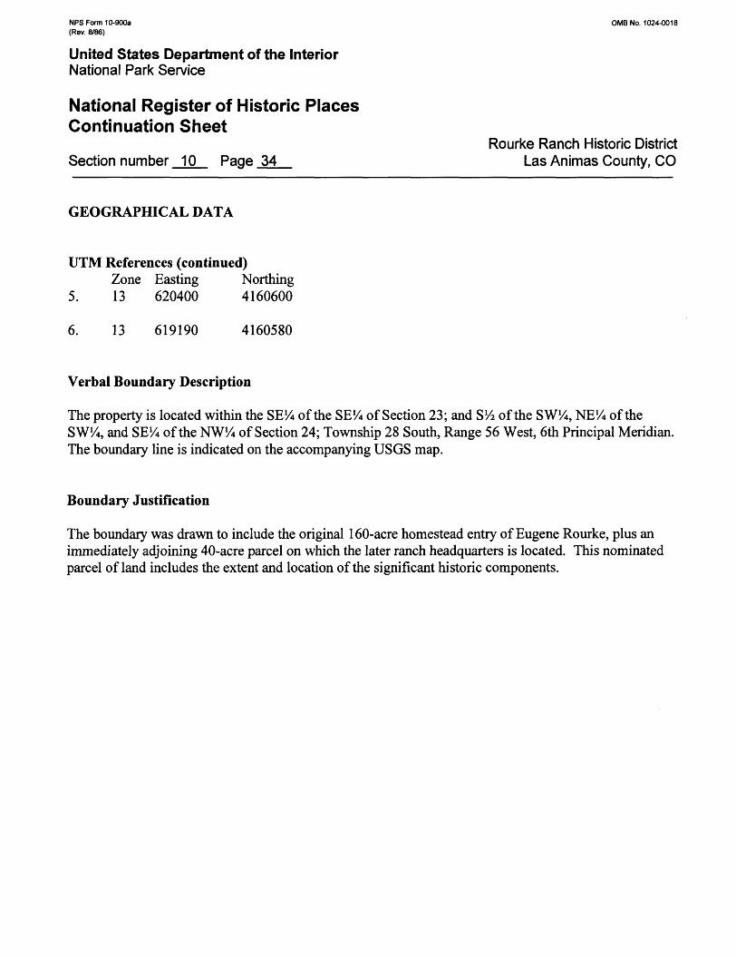
NFS Form 10-900a (Rev. 8/86)
OMB No. 1024-0018
United States Department of the InteriorNational Park Service
National Register of Historic Places Continuation Sheet
Section number 10 Page 34Rourke Ranch Historic District
Las Animas County, CO
GEOGRAPHICAL DATA
UTM References (continued)Zone Easting Northing
5. 13 620400 4160600
6. 13 619190 4160580
Verbal Boundary Description
The property is located within the SEtt of the SEVi of Section 23; and S l/2 of the SW%, NE% of the SW%, and SE% of the NWVi of Section 24; Township 28 South, Range 56 West, 6th Principal Meridian. The boundary line is indicated on the accompanying USGS map.
Boundary Justification
The boundary was drawn to include the original 160-acre homestead entry of Eugene Rourke, plus an immediately adjoining 40-acre parcel on which the later ranch headquarters is located. This nominated parcel of land includes the extent and location of the significant historic components.
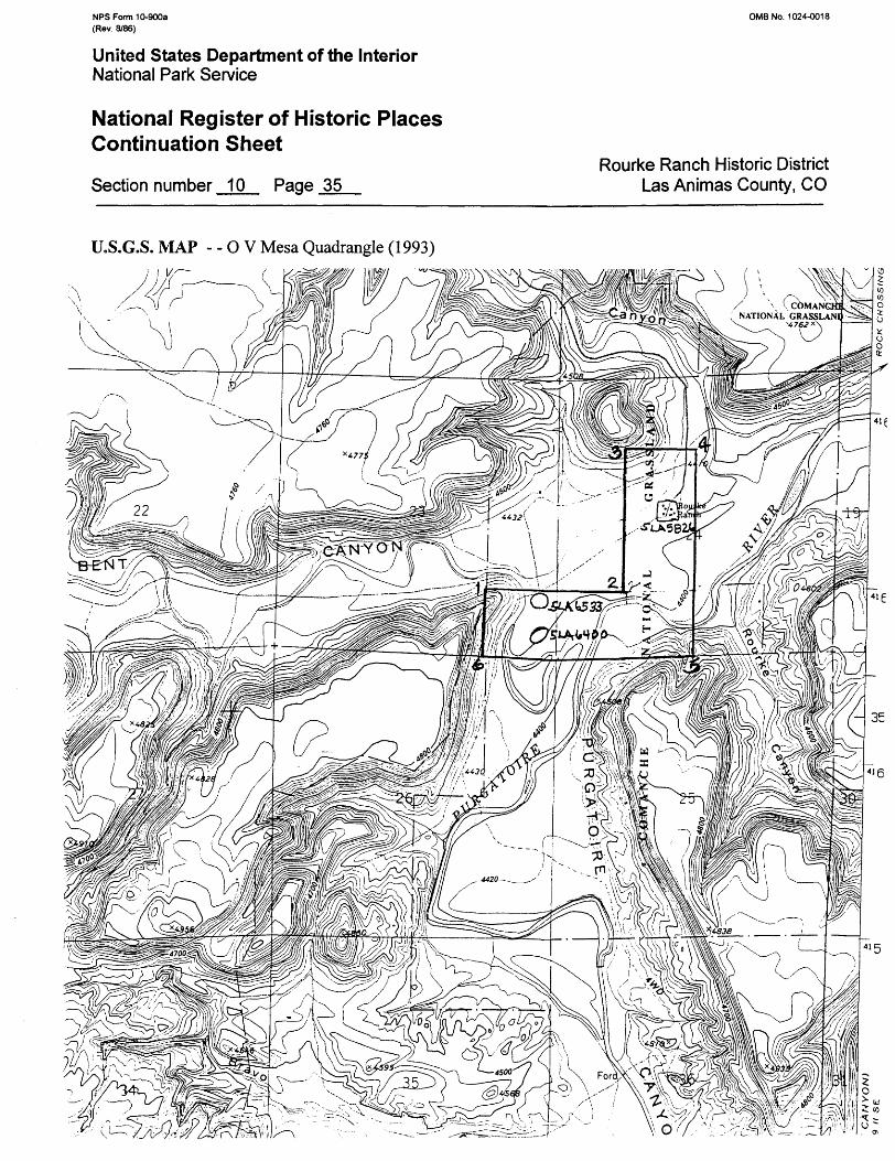
NFS Form 10-900a (Rev. S/86)
OMBNo. 1024-0018
United States Department of the InteriorNational Park Service
National Register of Historic Places Continuation Sheet
Section number 10 Page 35Rourke Ranch Historic District
Las Animas County, CO
U.S.G.S. MAP - - O V Mesa Quadrangle (1993)
NFS Form 10-900a OMB No. 1024-0018 (Rev. 8/86)
United States Department of the InteriorNational Park Service
National Register of Historic PlacesContinuation Sheet
Rourke Ranch Historic District Section number __ Page 36 Las Animas County, CO
PHOTOGRAPH LOG
The following information is the same for all of the photographs:
Property Name: Rourke Ranch Historic DistrictLocation: Comanche National Grasslands, Las Animas County, ColoradoPhotographer: JonathonC. HornNegatives on file: Alpine Archaeological Consultants, Inc., Montrose, CO
Photograph #1Date: August 11,1999Overview of Rourke Ranch complex, looking west. New feed structure, barn, and storage building at farleft, stable just left of center, bunkhouse center, main house behind tree, and garage at far right. (RourkeRanch Headquarters, 5LA5826).
Photograph #2Date: August 11,1999Overview of Rourke Ranch complex, looking northeast. Main house at far left, bunkhouse left of center,hay storage structure right of center, concrete storage building and barn at right. (Rourke RanchHeadquarters, 5LA5826).
Photograph #3Date: August 11, 1999Overview of Rourke Ranch complex, looking south. Main house at center, bunkhouse behind tree,garage left of center, and stable far left. (Rourke Ranch Headquarters, 5LA5826).
Photograph #4Date: August 11, 19993A view of south and east elevations of main house. (Rourke Ranch Headquarters, 5LA5826).
Photograph #5Date: August 11,19993/4 view of south and west elevations of south wing of main house. (Rourke Ranch Headquarters,5LA5826).
Photograph #6Date: August 11,1999West end of south elevation of main house showing overhanging porch supported by juniper posts.(Rourke Ranch Headquarters, 5LA5826).
NPS Form 10-900a 0MB No. 1024-0018 (Rev. 8/86)
United States Department of the InteriorNational Park Service
National Register of Historic PlacesContinuation Sheet
Rourke Ranch Historic District Section number __ Page 37 Las Animas County, CO
Photograph #1Date: September 28-29,19923/4 view of north and west elevations of west end of main house. (Rourke Ranch Headquarters,5LA5826).
Photograph #8Date: August 11, 1999North elevation of main house with part of west elevation to right. Note addition containing bathroomsat center of elevation. (Rourke Ranch Headquarters, 5LA5826).
Photograph #9Date: August 11,1999% view of east and north elevations of main house. Note entry into attic high in gable end. (RourkeRanch Headquarters, 5LA5826).
Photograph #10Date: September 28-29,1992Original adobe roof and adobe chimney beneath present gable roof of main house. View is to the westfrom the opening in the gable in the east elevation. (Rourke Ranch Headquarters, 5LA5826).
Photograph #11Date: September 28-29,1992Interior detail of the southeast corner of the westernmost room of the main house. Adobe fireplace withplain board mantle at left, interior doorway with pedimented lintel just left of center, built-in cabinetwith decorative scrolled surround and paneled doors just right of center, and exterior doorway withpedimented surround at right. (Rourke Ranch Headquarters, 5LA5826).
Photograph #12Date: September 28-29,1992Interior detail of 4-over-4 double-hung wood sash window in main house. Note pedimented surroundand deep window box reaching nearly to floor level. (Rourke Ranch Headquarters, 5LA5826).
Photograph #13Date: August 11,19993/4 view of south and west elevations of garage. (Rourke Ranch Headquarters, 5LA5826).
Photograph #14Date: September 28-29,19923/4 view of south and east elevations of garage. Note large wooden double doors on front. (RourkeRanch Headquarters, 5LA5826).
NPS Form 10-900a OMB No. 1024-0018 (Rev. 8/86)
United States Department of the InteriorNational Park Service
National Register of Historic PlacesContinuation Sheet
Rourke Ranch Historic District Section number __ Page 38 Las Animas County, CO
Photograph #15Date: September 28-29, 1992Interior of garage showing stone masonry. View is to the northwest. (Rourke Ranch Headquarters,5LA5826).
Photograph #16Date: September 28-29,1992% view of west and south elevations of the bunkhouse. (Rourke Ranch Headquarters, 5LA5826).
Photograph #17Date: September 28-29, 19923A view of east and north elevations of bunkhouse. (Rourke Ranch Headquarters, 5LA5826).
Photograph #18Date: August 11, 19993A view of south and east elevations of stable. Note damage to roof on western portion of structure from1997 windstorm. (Rourke Ranch Headquarters, 5LA5826).
Photograph #19Date: September 28-29, 19923A view of south and east elevations of stable showing structure before damage by 1997 windstorm.(Rourke Ranch Headquarters, 5LA5826).
Photograph #20Date: August 11, 19993/4 view of south and west elevations of stable. Note damage to roof on western portion of structure from1997 windstorm and pole framework being erected to provide protective covering for structure. (RourkeRanch Headquarters, 5LA5826).
Photograph #21Date: September 28-29,19923A view of south and west elevations of stable showing structure before damage by 1997 windstorm.(Rourke Ranch Headquarters, 5LA5826).
Photograph #22Date: August 11,1999Eastern and central portion of the south elevation of stable. Note damage to roof on left from 1997windstorm. (Rourke Ranch Headquarters, 5LA5826).
NPS Form 10-900a OMB No. 1024-0018 (Rev. 8/86)
United States Department of the InteriorNational Park Service
National Register of Historic PlacesContinuation Sheet
Rourke Ranch Historic District Section number _ Page 39 Las Animas County, CO
Photograph #23Date: September 28-29,1992Eastern and central portion of the south elevation of stable before damage by 1997 windstorm. (RourkeRanch Headquarters, 5LA5826).
Photograph #24Date: September 28-29,1992Construction detail of interior of enclosed room at east end of stable. Note jacal construction of wallswith upright juniper posts plastered with mud. (Rourke Ranch Headquarters, 5LA5826).
Photograph #25Date: August 11,1999North elevation of stable. Note damage to roof from 1997 windstorm and pole framework being erectedto provide protective covering for structure. (Rourke Ranch Headquarters, 5LA5826).
Photograph #26Date: September 28-29, 1992North elevation of stable before 1997 windstorm.
Photograph #27Date: August 11, 1999North and east elevations of barn. (Rourke Ranch Headquarters, 5LA5826).
Photograph #28Date: August 11,1999South elevation of barn. View is to the northeast. (Rourke Ranch Headquarters, 5LA5826).
Photograph #29Date: September 28-29, 1992Interior detail of southwestern portion of barn showing log and post construction,cottonwood latias supporting roof, and feed troughs along west wall. (Rourke Ranch Headquarters,5LA5826).
Photograph #30Date: August 11,1999Adobe doghouse with gabled roof. View is to the north. (Rourke Ranch Headquarters, 5LA5826).
NPS Form 10-900a 0MB No. 1024-0018 (Rev. 8/86)
United States Department of the InteriorNational Park Service
National Register of Historic PlacesContinuation Sheet
Rourke Ranch Historic District Section number _ Page 40 Las Animas County, CO
Photograph #31Date: August 11, 1999Pole frame hay storage structure. Note doghouse to the right. View is to the west. (Rourke RanchHeadquarters, 5LA5826).
Photograph #32Date: August 11,1999West elevation of concrete storage building. (Rourke Ranch Headquarters, 5LA5826).
Photograph #33Date: August 11, 1999% view of south and east elevations of cinderblock feed structure. Note barn to the left. (Rourke RanchHeadquarters, 5LA5826).
Photograph #34Date: August 11,1999Small wooden post, board, and wire framework. View is to the northeast. (Rourke Ranch Headquarters,5LA5826).
Photograph #35Date: August 11, 1999Rock alignments outlining northeast corner of a room in adobe mound of possible residence (Structure1). View is to the west. (Original Eugene Rourke Ranch, 5LA6400).
Photograph #36Date: August 11, 1999Rock alignment in Structure 2 area. View is to the south. (Original Eugene Rourke Ranch, 5LA6400).
Photograph #37Date: August 11, 1999Portion of stone structure (Structure 3) eroding from floodplain cutbank. View is to the northwest.(Original Eugene Rourke Ranch, 5LA6400).
Photograph #3 8Date: August 11,1999Rock alignment (Feature 1) east of the possible residence. View is to the southeast. (Original EugeneRourke Ranch, 5LA6400).
NFS Form 10-900a 0MB No. 1024-0018 (Rev. 8/86)
United States Department of the InteriorNational Park Service
National Register of Historic PlacesContinuation Sheet
Rourke Ranch Historic District Section number _ Page 41 Las Animas County, CO
Photograph #39Date: August 11, 1999Stone-lined well (Feature 2) eroding from floodplain cutbank. View is to the north. (Original EugeneRourke Ranch, 5LA6400).
Photograph #40Date: August 11,1999Juniper posts that delineate animal stable (Structure 4). View is to the northwest. (Original EugeneRourke Ranch, 5LA6400).
Photograph #41Date: August 11, 1999Sandstone blocks that probably served as fence post supports and now delineate fence alignment. Noteposts of possible animal stable remains in background. View is to the north. (Original Eugene RourkeRanch, 5LA6400).
Photograph #42Date: August 11,1999Juniper posts with tenon ends that are part of the remains of a possible large animal enclosure (Feature3). View is to the northeast. (Original Eugene Rourke Ranch, 5LA6400).
Photograph #43Date: August 11, 1999Overview of stable and corral complex after wildfire in 1996 passed through area. View is to the east.(Corral and animal shed, 5LA6533).
Photograph #44Date: September 28-29, 1992Overview of stable and corral complex before wildfire in 1996 passed through area. View is to the east.(Corral and animal shed, 5LA6533).
Photograph #45Date: August 11,1999View of south side of stable through corral complex. View is to the north. (Corral and animal shed,5LA6533).
Photograph #46Date: August 11,19993A view of west elevation and western portion of south elevation of stable. View is to the northeast.(Corral and animal shed, 5LA6533).
NFS Form 10-900a OMB No. 1024-0018 (Rev. 8/86)
United States Department of the InteriorNational Park Service
National Register of Historic PlacesContinuation Sheet
Rourke Ranch Historic District Section number _ Page 42 Las Animas County, CO
Photograph #47Date: August 11,19993A view of west and south elevations of stone room on east end of stable. View is to the northeast.(Corral and animal shed, 5LA6533).
Photograph #48Date: August 11, 1999Construction detail of interior back wall of stable showing stone construction, large roof beams withwire hold-downs, window opening, and corrugated roofing. View is to the north. (Corral and animalshed, 5LA6533).
Photograph #49Date: August 11, 19993/4 view of south and east elevations of stone room on east end of stable with loading chute off ofattached corral. View is to the northwest. (Corral and animal shed, 5LA6533).
Photograph #50Date: August 11,1999Eastern and central portion of north elevation of stable. View is to the southwest. (Corral and animalshed, 5LA6533).
Photograph #51Date: August 11,1999Western portion of north elevation of stable. View is to the southeast. (Corral and animal shed,5LA6533).
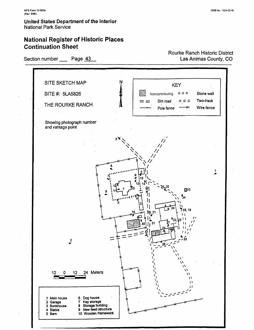
NPS Form 10-900a (Rev. 8/86)
0MB No. 1024-0018
United States Department of the InteriorNational Park Service
National Register of Historic Places Continuation Sheet
Section number _ Page 43Rourke Ranch Historic District
Las Animas County, CO
SITE SKETCH MAP
SITE#: 5LA5826
THE ROURKE RANCH
Showing photograph number and vantage point
KEYNoncontributing o o o •
= = Dirt road . =. = - ——*- Pole fence ——*~
Stone wall
Two-track
Wire fence
12 12 24 Meters
Main houseGarageBunkhouseStableBam
6 Doghouse7 Hay storage8 Storage building9 New feed structure10 Wooden framework
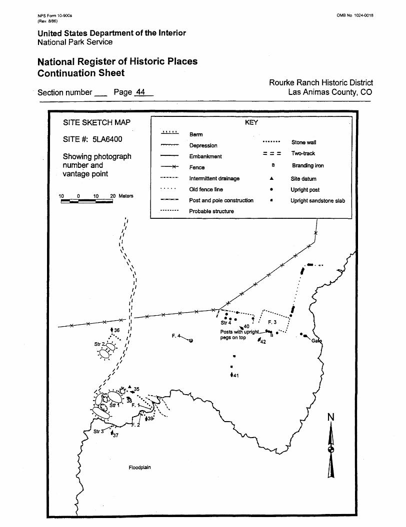
NPS Form 10-900a (Rev. 8/86)
0MB No. 1024-0018
United States Department of the InteriorNational Park Service
National Register of Historic Places Continuation Sheet
Section number _ Page 44Rourke Ranch Historic District
Las Animas County, CO
SITE SKETCH MAP
SITE#: 5LA6400
Showing photograph number and vantage point
10 10 20 Meters
KEY
Berm
Depression
Embankment
Fence
Intermittent drainage
Old fence line
Post and pole construction
Probable structure
Stone wall
Two-track
Branding iron
Site datum
Upright post
Upright sandstone slab
Posts with upright—-*•• pegs on top ^
42
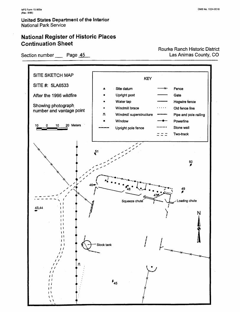
NFS Form 10-900a (Rev. 8/86)
0MB No. 1024-0018
United States Department of the InteriorNational Park Service
National Register of Historic Places Continuation Sheet
Section number _ Page 45Rourke Ranch Historic District
Las Animas County, CO
SITE SKETCH MAP
SITE#: 5LA6533
After the 1996 wildfire
Showing photograph number and vantage point
10 10 20 Meters
KEY
Site datum
Upright post
Water tap
Windmill brace
Windmill superstructure
Window
Upright pole fence
Fence
Gate
Hogwire fence
Old fence line
Pipe and pole railing
Powerline
Stone wall
Two-track