Embed Size (px)
Citation preview
National Resources National Resources InventoryInventory
byby
Robert N. JonesRobert N. Jones
State ConservationistState Conservationist
USDA-Natural Resources Conservation USDA-Natural Resources Conservation Service Service

Seven Decades of Resource Seven Decades of Resource InventoriesInventories
National Erosion National Erosion Reconnaissance Reconnaissance Survey of 1934Survey of 1934
Aerial photography is Aerial photography is used to collect NRI data used to collect NRI data in modern surveys.in modern surveys.

The National Resources The National Resources InventoryInventory
Statistical surveyStatistical surveyConducted by Natural Resources Conducted by Natural Resources
Conservation Service (NRCS)Conservation Service (NRCS)

About the Inventory ProcessAbout the Inventory Process
NRI data are collected at selected NRI data are collected at selected sample sitessample sites
Sample sites are located in all Sample sites are located in all countiescounties
Data are collected using photo-Data are collected using photo-interpretation and other remote interpretation and other remote sensing methodssensing methods
Results produce estimatesResults produce estimates

Alabama Land UseAlabama Land Use29 Million Acres – Non Federal 29 Million Acres – Non Federal
Rural LandRural Land
73% Forest73% Forest 12% Pasture12% Pasture 10% Cropland10% Cropland 2% CRP2% CRP 1% Range land1% Range land 2% Other rural2% Other rural

CroplandCropland 1,591,400 1,591,400 PasturelandPastureland 221,000 221,000 Rangeland Rangeland 16,000 16,000 Developed landDeveloped land 766,200 766,200 CRPCRP 521,900 521,900 ForestlandForestland 302,300 302,300

Urbanization and Urbanization and DevelopmentDevelopment
Alabama Alabama DevelopeDeveloped land in d land in 1997– 1997– 2,409,002,409,0000acres acres (8%)(8%) However, from 1992-97 more
land was developed (445,300 acres) than during 1982-92 (320,000 acres)

Forest LandForest Land
Over 21 Over 21 million acresmillion acres
Between Between 1982 and 1982 and 1997, 1997, increased by increased by 302,300302,300

What to Look for in the What to Look for in the FutureFuture
To build a databaseTo build a database To increase the To increase the
breadth of analyses breadth of analyses supported by the supported by the NRINRI

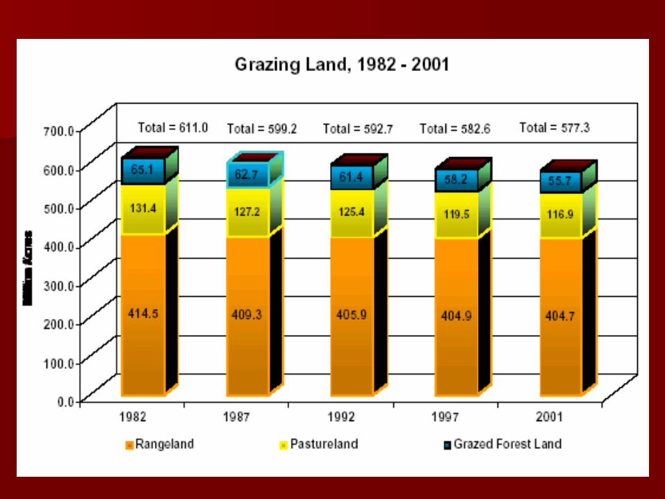
2001 Key Findings2001 Key Findings
In Million AcresIn Million Acres19821982 20012001
Cropland Cropland 420 420 370370
PasturelandPastureland 131131 117117
RangelandRangeland 415415 405405
ForestlandForestland 4848 5151
DevelopedDeveloped 7373 108108


More Key FindingsMore Key Findings
Control of erosion rates Control of erosion rates sustainedsustained
Erosion on cropland Erosion on cropland Erosion per acre Erosion per acre HEL HEL

SummarySummary Statistical surveyStatistical survey
Provides nationally Provides nationally consistent statistical dataconsistent statistical data
Culminates in a variety of Culminates in a variety of databases, assessments, databases, assessments, publicationspublications
Useful for many purposes Useful for many purposes and at many levelsand at many levels
ReferenceReference
National Resources National Resources Inventory website:Inventory website:
http://www.nrcs.usda.gov/technical/NRI/http://www.nrcs.usda.gov/technical/NRI/