Embed Size (px)
Citation preview
national earthquake hazards reduction program
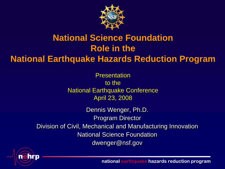
National Science Foundation Role in the
National Earthquake Hazards Reduction Program
Presentation to the
National Earthquake Conference April 23, 2008
Dennis Wenger, Ph.D.Program Director
Division of Civil, Mechanical and Manufacturing InnovationNational Science Foundation
Dennis Wenger, Ph.D.Program Director
Division of Civil, Mechanical and Manufacturing InnovationNational Science Foundation

national earthquake hazards reduction program
Office of theInspector General
(OIG)
DirectorDeputy Director
National Science Board(NSB)
Mathematical& PhysicalSciences
(MPS)
Geosciences(GEO)
Engineering(ENG)
Computer &Information Science &
Engineering(CISE)
BiologicalSciences
(BIO)
Office of Cyberinfrastructure
Office of Equal Employment Opportunity Programs
Office of the General Counsel
Office of Integrative Activities
Office of International Science & EngineeringOffice of Legislative &Public Affairs
Office of Polar Programs
Social, Behavioral
& EconomicSciences
(SBE)
Education & Human
Resources(EHR)
Budget, Finance & Award
Management(BFA)
Information& Resource Management
(IRM)
National Science Foundation
NEHRP Activities

national earthquake hazards reduction program
NEHRP Activities funded by NSF
• Directorate for GeosciencesIncorporated Research Institutions for Seismology Southern California Earthquake Center Fundamental Research on EarthquakesEarthScope (Related non-NEHRP activity)
• Directorate for EngineeringEarthquake Engineering Research Centers, now graduatedLearning from Earthquakes Program National Hazards Research CenterUnsolicited Fundamental Research on Earthquake Engineering and Social Science and Public Policy Aspects of Disasters George E. Brown, Jr. Network for Earthquake Engineering Simulation
national earthquake hazards reduction program
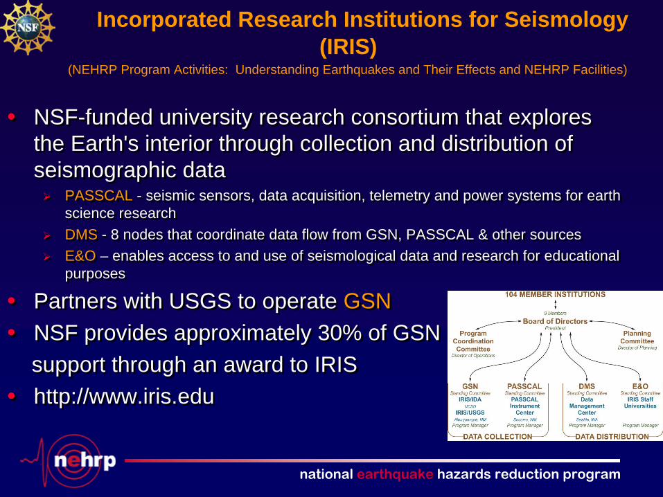
Incorporated Research Institutions for Seismology (IRIS)
• NSF-funded university research consortium that explores the Earth's interior through collection and distribution of seismographic data
PASSCAL - seismic sensors, data acquisition, telemetry and power systems for earth science researchDMS - 8 nodes that coordinate data flow from GSN, PASSCAL & other sources E&O – enables access to and use of seismological data and research for educational purposes
• Partners with USGS to operate GSN• NSF provides approximately 30% of GSN
support through an award to IRIS• http://www.iris.edu
(NEHRP Program Activities: Understanding Earthquakes and Their Effects and NEHRP Facilities)
national earthquake hazards reduction program
Southern California Earthquake Center
• “Collaboratory” co-funded by NSF and USGSTripartite mission:
• Gather data on earthquakes in Southern California • Integrate information into a comprehensive, physics-based understanding
of earthquake phenomena • Communicate to the community at large knowledge for reducing
earthquake risk 2005-2006: Community Fault, Velocity, and Block Models developedRenewed for 5 years starting February 2007 (SCEC III)
• “Collaboratory” co-funded by NSF and USGSTripartite mission:
• Gather data on earthquakes in Southern California • Integrate information into a comprehensive, physics-based understanding
of earthquake phenomena• Communicate to the community at large knowledge for reducing
earthquake risk2005-2006: Community Fault, Velocity, and Block Models developedRenewed for 5 years starting February 2007 (SCEC III)
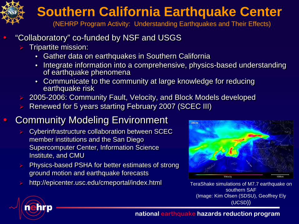
• Community Modeling EnvironmentCyberinfrastructure collaboration between SCEC member institutions and the San Diego Supercomputer Center, Information Science Institute, and CMUPhysics-based PSHA for better estimates of strong ground motion and earthquake forecastshttp://epicenter.usc.edu/cmeportal/index.html
• Community Modeling EnvironmentCyberinfrastructure collaboration between SCEC member institutions and the San Diego Supercomputer Center, Information Science Institute, and CMUPhysics-based PSHA for better estimates of strong ground motion and earthquake forecastshttp://epicenter.usc.edu/cmeportal/index.html
(NEHRP Program Activity: Understanding Earthquakes and Their Effects)
TeraShake simulations of M7.7 earthquake on southern SAF
(Image: Kim Olsen (SDSU), Geoffrey Ely (UCSD))
national earthquake hazards reduction program
Fundamental Research on Earthquakes
• GEO/EAR programs fund fundamental earthquake-related science through general program solicitations
Geophysics, Tectonics, Continental Dynamics, Instrumentation and Facilities
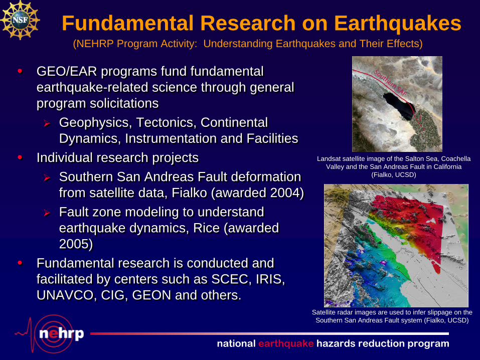
• Individual research projects Southern San Andreas Fault deformation from satellite data, Fialko (awarded 2004)Fault zone modeling to understand earthquake dynamics, Rice (awarded 2005)
• Fundamental research is conducted and facilitated by centers such as SCEC, IRIS, UNAVCO, CIG, GEON and others.
• GEO/EAR programs fund fundamental earthquake-related science through general program solicitations
Geophysics, Tectonics, Continental Dynamics, Instrumentation and Facilities
• Individual research projects Southern San Andreas Fault deformation from satellite data, Fialko (awarded 2004)Fault zone modeling to understand earthquake dynamics, Rice (awarded 2005)
• Fundamental research is conducted and facilitated by centers such as SCEC, IRIS, UNAVCO, CIG, GEON and others.
Landsat satellite image of the Salton Sea, Coachella Valley and the San Andreas Fault in California
(Fialko, UCSD)
Satellite radar images are used to infer slippage on the Southern San Andreas Fault system (Fialko, UCSD)
(NEHRP Program Activity: Understanding Earthquakes and Their Effects)

national earthquake hazards reduction program
Related Non-NEHRP Activities
• A multipurpose array of instruments and observatories to advance understanding of the structure, evolution and dynamics of the North American continent
San Andreas Fault Observatory at Depth (SAFOD) Plate Boundary Observatory - geodetic componentUSARRAY- short-term, intermediate-term and permanent seismograph installation
• Installation conducted in partnership with USGS
• 3.1 km San Andreas Fault borehole• 852 permanent GPS stations• 103 borehole strainmeters • 5 laser strainmeters• 39 Permanent seismic stations
• 400 transportable seismic stations occupying 2000 sites
• 27 magneto-telluric systems• 100 campaign GPS stations• 2400 campaign seismic stations

national earthquake hazards reduction program
Related Non-NEHRP Activities
EarthScope has already:• Captured eruptive sequences at Mt. St. Helens and Augustine• Captured ETS events in Cascadia (seismic, GPS, and strainmeter)• Drilled across San Andreas Fault• Begun determining Earth structure from “noise”
national earthquake hazards reduction program
NSF Earthquake Engineering Research Centers (FY 1998 – FY 2007) (NEHRP Program Activity: Understanding Earthquakes and Their Effects)
• Mid-America Earthquake (MAE) CenterLead: University of Illinois, Urbana-ChampaignFocus: Earthquakes and their effects in Mid-America http://mae.ce.uiuc.edu
• MCEER – Earthquake Engineering to Extreme EventsLead: SUNY BuffaloFocus: Critical infrastructure, hospitals, response & recovery http://mceer.buffalo.edu
• Pacific Earthquake Engineering Research (PEER) CenterLead: University of California, BerkeleyFocus: Performance-based earthquake engineeringhttp://peer.berkeley.edu
national earthquake hazards reduction program
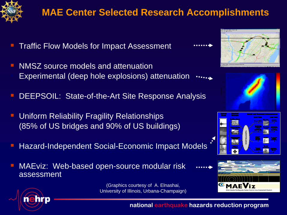
MAE Center Selected Research Accomplishments
Traffic Flow Models for Impact Assessment
NMSZ source models and attenuation• Experimental (deep hole explosions) attenuation
DEEPSOIL: State-of-the-Art Site Response Analysis
Uniform Reliability Fragility Relationships(85% of US bridges and 90% of US buildings)
Hazard-Independent Social-Economic Impact Models
MAEviz: Web-based open-source modular risk assessment
(Graphics courtesy of A. Elnashai, University of Illinois, Urbana-Champaign)
national earthquake hazards reduction program
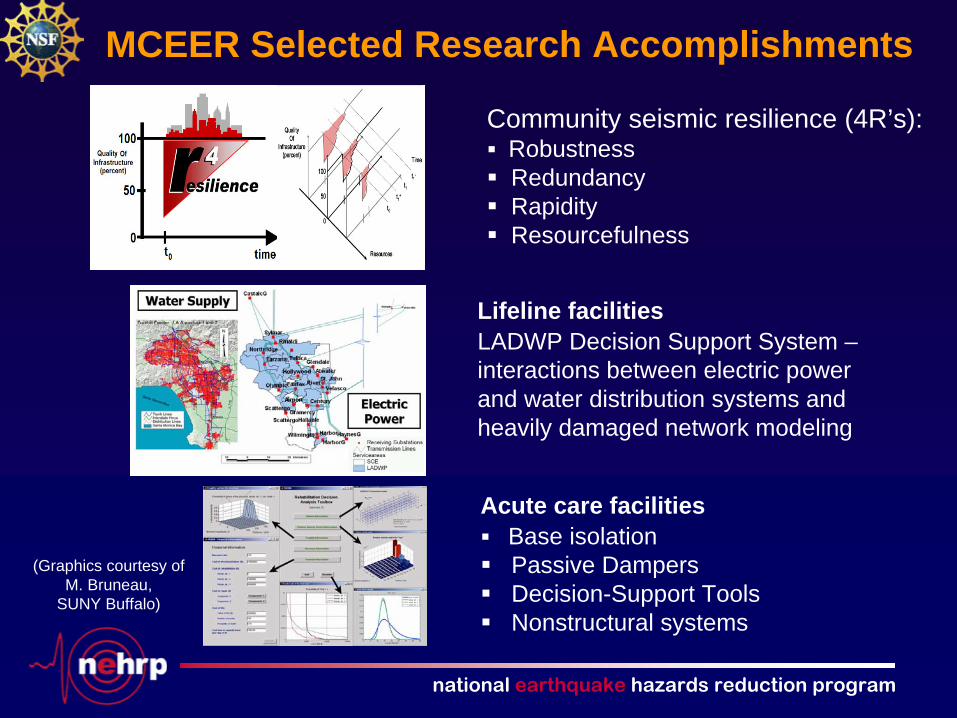
MCEER Selected Research Accomplishments
Lifeline facilities LADWP Decision Support System – interactions between electric power and water distribution systems and heavily damaged network modeling
Acute care facilitiesBase isolationPassive Dampers Decision-Support Tools Nonstructural systems
Community seismic resilience (4R’s):RobustnessRedundancyRapidity Resourcefulness
(Graphics courtesy of M. Bruneau,
SUNY Buffalo)
national earthquake hazards reduction program
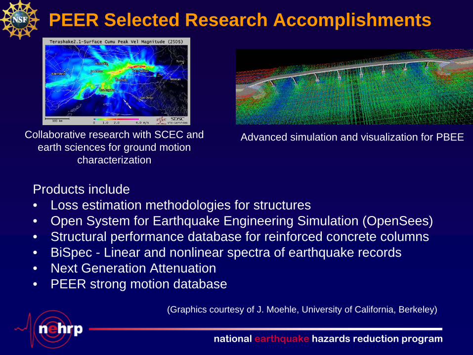
PEER Selected Research Accomplishments
Collaborative research with SCEC and earth sciences for ground motion
characterization
Advanced simulation and visualization for PBEE
(Graphics courtesy of J. Moehle, University of California, Berkeley)
Products include• Loss estimation methodologies for structures• Open System for Earthquake Engineering Simulation (OpenSees)• Structural performance database for reinforced concrete columns• BiSpec - Linear and nonlinear spectra of earthquake records • Next Generation Attenuation• PEER strong motion database
national earthquake hazards reduction program
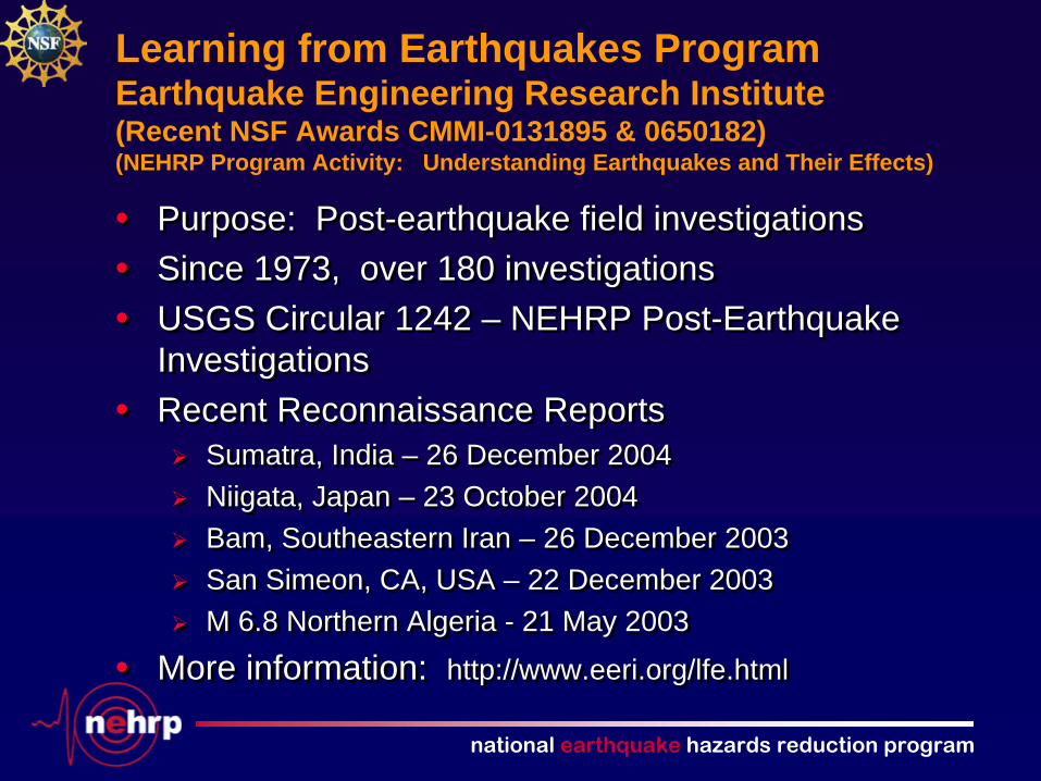
Learning from Earthquakes Program Earthquake Engineering Research Institute (Recent NSF Awards CMMI-0131895 & 0650182) (NEHRP Program Activity: Understanding Earthquakes and Their Effects)
• Purpose: Post-earthquake field investigations• Since 1973, over 180 investigations• USGS Circular 1242 – NEHRP Post-Earthquake
Investigations • Recent Reconnaissance Reports
Sumatra, India – 26 December 2004Niigata, Japan – 23 October 2004Bam, Southeastern Iran – 26 December 2003San Simeon, CA, USA – 22 December 2003M 6.8 Northern Algeria - 21 May 2003
• More information: http://www.eeri.org/lfe.html
• Purpose: Post-earthquake field investigations• Since 1973, over 180 investigations• USGS Circular 1242 – NEHRP Post-Earthquake
Investigations• Recent Reconnaissance Reports
Sumatra, India – 26 December 2004Niigata, Japan – 23 October 2004Bam, Southeastern Iran – 26 December 2003San Simeon, CA, USA – 22 December 2003M 6.8 Northern Algeria - 21 May 2003
• More information: http://www.eeri.org/lfe.html

national earthquake hazards reduction program
Natural Hazards Center University of Colorado, Boulder (NSF Award CMMI-0408499) (NEHRP Program Activity: Understanding Earthquakes and Their Effects)
• Purpose: To advance and communicate knowledge on hazard mitigation and disaster preparedness, response, and recovery
• Co-funding: NSF, USGS, FEMA, and other federal agencies• Publications include
Natural Hazards Observer (bimonthly)Disaster Research (biweekly e-newsletter)Natural Hazards Review Journal (joint w/ASCE)
• Quick response program and reports (post-disaster studies)• Annual Workshop: July 8-11, 2007• More information: http://www.colorado.edu/hazards/
national earthquake hazards reduction program
Fundamental Research ENG/CMMI Unsolicited Proposals Examples of Recent Awards (NEHRP Program Activity: Understanding Earthquakes and Their Effects)
• Structural Systems and Hazard Mitigation of StructuresSensitivity analysis of concrete gravity dams subjected to non-uniform seismic excitations Performance-based seismic design of concentrically braced steel frame members
• GeoEnvironmental Engineering and GeoHazards MitigationLiquefaction resistance of aged soilsPBEE using paleoseismic techniques Landslide generated tsunamis
• Infrastructure Management and Hazard ResponseInvestment planning for regional natural disaster mitigation Measuring cross-community disaster preparedness and resiliency: theoretical and practical application development

national earthquake hazards reduction program
Infrastructure Management and Hazard Response Projects
• Social Science and Multidisciplinary Research• Currently over 50 active awards• FEMA’S USAR Task force Deployments:
Implications for the management of emergency response
• Prevalence and Preparedness for Conjoint Natural and Technological Disasters
• Family Business Response to Federal Disaster Assistance
national earthquake hazards reduction program
Infrastructure Management and Hazard Response Projects (cont.)
• Agency Within Disaster Preparedness and Response: The Role of Poverty and Disability
• Improvisation and Sensemaking in Sudden Crisis• The October 2006 Federal disaster in Buffalo, NY: An
Investigation of First and Second Responder Operations • The Dynamics of Collaboration in Emergency Planning for
America’s Schools • Responding to the Unexpected: Understanding Travelers’
Behavioral Choices in the Wake of the Mississippi River Bridge Collapse
• Protective Action Decision Making in Wildfires
• Agency Within Disaster Preparedness and Response: The Role of Poverty and Disability
• Improvisation and Sensemaking in Sudden Crisis• The October 2006 Federal disaster in Buffalo, NY: An
Investigation of First and Second Responder Operations• The Dynamics of Collaboration in Emergency Planning for
America’s Schools• Responding to the Unexpected: Understanding Travelers’
Behavioral Choices in the Wake of the Mississippi River Bridge Collapse
• Protective Action Decision Making in Wildfires
national earthquake hazards reduction program
Human and Social Dynamics
• A NSF foundation wide five year solicitation supporting multidisciplinary research in social science, physical science, natural science and engineering.
• Decision-making under Risk and Uncertainty focus area has supported about 50 social science proposals on hazards and disasters.
• Total support for research on hazards and disasters is in excess of $30,000,000.
national earthquake hazards reduction program
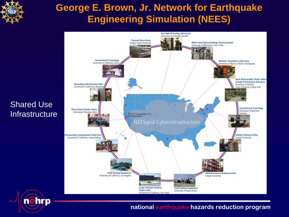
George E. Brown, Jr. Network for Earthquake Engineering Simulation (NEES)
Shared Use Infrastructure

national earthquake hazards reduction program
NSF NEESR Project CMMI-0529903 “NEESWood” (Lead: Colorado State University)
Dual 6DOF Shake Tables at SUNY Buffalo
NEES Site
Full-scale test of a residential structure November 2006
Photo courtesy of the NEESwood project web site: http://www.engr.colostate.edu/NEESWood/
national earthquake hazards reduction program
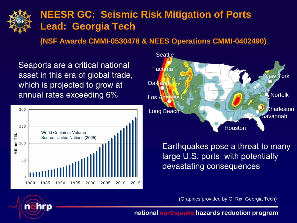
Seattle
Oakland
Los Angeles
Long Beach
Houston
Tacoma
SavannahCharleston
Norfolk
New York
Seaports are a critical national asset in this era of global trade, which is projected to grow at annual rates exceeding 6%
0
50
100
150
200
1980 1985 1990 1995 2000 2005 2010 2015
Millio
n T
EU World Container Volume
Source: United Nations (2005)
Earthquakes pose a threat to many large U.S. ports with potentially devastating consequences
NEESR GC: Seismic Risk Mitigation of Ports Lead: Georgia Tech(NSF Awards CMMI-0530478 & NEES Operations CMMI-0402490)
(Graphics provided by G. Rix, Georgia Tech)
national earthquake hazards reduction program
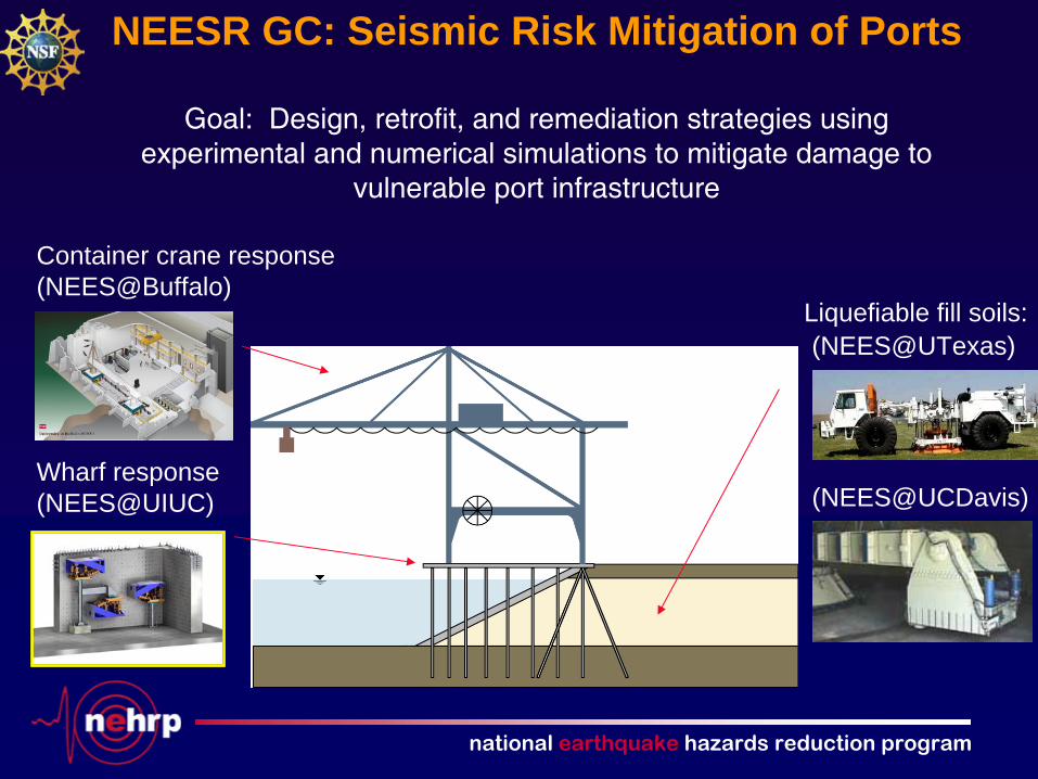
Goal: Design, retrofit, and remediation strategies using experimental and numerical simulations to mitigate damage to
vulnerable port infrastructure
Liquefiable fill soils:
Wharf response(NEES@UIUC)
Container crane response (NEES@Buffalo)
NEESR GC: Seismic Risk Mitigation of Ports
(NEES@UCDavis)
(NEES@UTexas)

national earthquake hazards reduction program
National Science Foundation
http://www.nsf.govhttp://www.nsf.gov