Embed Size (px)
Citation preview
i
NATIVE
WOODLAND DEVELOPMENT IN THE NORTH YORK MOORS AND HOWARDIAN HILLS
FORESTRY COMMISSION - FOREST ENTERPRISE NORTH YORK MOORS NATIONAL PARK AUTHORITY HOWARDIAN HILLS AREA OF OUTSTANDING NATURAL BEAUTY JAC ENGLISH NATURE ROYAL FORESTRY SOCIETY
George F. Peterken

This page is intentionally blank
i
NATIVE WOODLAND DEVELOPMENT IN THE NORTH YORK
MOORS AND HOWARDIAN HILLS 2002
George F Peterken, OBE, D.Sc., M.I.C.For
CONTENTS Page No i Contents iii Summary iv Acknowledgements 1 1. INTRODUCTION 1 1.1. Objective of report 1 1.2. Approach 2 1.3. Policy framework 7 2. DESCRIPTION 7 2.1. Geology, land form, drainage and soils 8 2.2. Components of the landscape 11 2.3. Development of the modern forest cover 17 2.4. Ancient woodlands 19 2.5. Landscape zones 25 3. FOREST HABITAT NETWORKS (FHN) 25 3.1. FHNs in general 25 3.2. The relationship between forest land and the rest of the landscape 28 3.3. Woodland size and separation 29 3.4. Habitat range within a FHN 29 3.5. Significance of ancient woodland within a FHN 29 3.6. Links within a forest network 30 3.7. FHNs and forest management 31 3.8. Limitations on the restoration of a FHN 31 3.9. The significance of the matrix 31 3.10. The benefits of a restored FHN 33 4. QUANTIFYING LAND TYPES AND PATTERNS 33 4.1. Method 34 4.2. Area statement 35 4.3. Area estimates by the North York Moors NP and Howardian Hills AONB 39 4.4. Land types within each zone of NYM 43 4.5. Core woodland 44 4.6. Semi-natural habitats in farmland 46 4.7. Forestry Commission holdings
ii
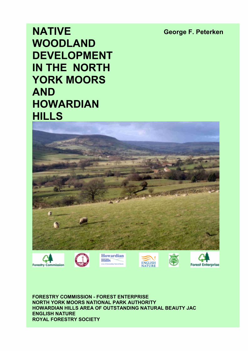
49 5. ECOLOGICAL ISSUES 49 5.1. Defining native tree species 51 5.2. Provenance 51 5.3. What counts as native woodland? 52 5.4. Age class considerations 55 5.5. Edge effects 56 5.6. Open space habitats in managed woodland 57 5.7. Relationships between forest and other habitats 58 5.8. Means of increasing native woodland 59 5.9. Ecological development of new woodland 59 5.10. Ecological isolation 62 5.11. The Dimbleby plots: an experiment in recreating native woodland. 63 6. EVALUATION OF NYM/HH FOREST PATTERN AND CONDITION 63 6.1. The NYM and HH as a whole 64 6.2. Network statistics 64 6.3. Moorland zone (1) 66 6.4. Moorland valleys (2) 67 6.5. Coastal zone and Esk catchment (3) 69 6.6. Western fringes (4) 70 6.7. Southern hills (5) 74 6.8. Howardian Hills 77 7. DEVELOPING A FOREST HABITAT NETWORK IN NYM/HH 78 7.1. Increasing the area of native woodland outside plantations 78 7.2. Plantation diversification: treatment in relation to native elements 80 7.3. Treatment of ancient and native woodland 81 7.4. Relationship between forested and other land. 82 7.5. Limiting biotic damage. 85 7.6. Relationship with land outside NYM/HH. 87 8. PRIORITIES vii The abbreviations, tables, figures and plates ix References COVER PHOTOGRAPH Central Farndale looking north west over Tenter Farm. The valley is a mixture of planned and earlier enclosures with a reasonable stock of boundary trees and shrubs.
iii
NATIVE WOODLAND DEVELOPMENT IN THE NORTH YORK MOORS AND HOWARDIAN HILLS
by George Peterken.
Summary This report reviews the options for expanding native woodland in the North York Moors and Howardian Hills. Its objective is to help the Forestry Commission, in partnership with the North York Moors National Park, Howardian Hills Area of Outstanding Natural Beauty, English Nature and the Royal Forestry Society (representing private owners), to develop a unified approach to this expansion. The combined areas are already well-forested by national standards – 21% of the land area is forested – but much of this forest – some 68% - is mainly stocked with introduced conifers, and in several districts the woods are sparsely scattered and poorly linked. The review is based on the concept of the Forest Habitat Network. This recognises that forest habitats have been reduced by millennia of clearance to small, isolated fragments, within which native wildlife is vulnerable to loss of diversity, and forest managers are hampered by several factors, from the absence of economies of scale to the need to preserve particular stands for landscape and wildlife. Restoration of an interlinked network of forest habitats would simultaneously make wildlife populations more resilient and reduce constraints on forestry operations. The report covers (i) forest pattern, (ii) forest management, (iii) treatment of trees outside forested land, (iv) linkages between woodland and (v) the role of non-woodland habitats within a forest habitat network. In sequence it:
• Outlines the policy framework for forest expansion and management (Chapter 1). • Describes the North York Moors and the Howardian Hills, and how the present
forest cover has developed (Chapter 2). • Summarises the Forest Habitat Network concept (Chapter 3). • Quantifies land types, and especially forest types (Chapter 4). • Considers several ecological issues relating to forest expansion and management
(Chapter 5). • Evaluates the present forest pattern and condition against Forest Habitat Network
norms (Chapter 6). • Recommends particular measures for native woodland expansion, related to
historic woodland types, and the need to fill gaps in the present network of forest habitats (Chapter 7), and identifies priorities (Chapter 8).
iv
Acknowledgements. This report has been drawn up with the active assistance of several staff of the organisations involved. Forestry Commission, through their North York Moors Forest District office in Pickering, co-ordinated the work under the leadership of Andrew Smith, and Nick Short supplied detailed statistics of land holdings. Jonathan Spencer, Forestry Commission ecologist, discussed the issues and possibilities on site. Paul Jackson of the Howardian Hills AONB, Rona Charles, Paul Harris and Mike Chapman of the North York Moors NPA, Graham Haddock of the Forestry Commission (FC), David Clayden of English Nature, Peter Leeson of the Woodland Trust, William Woods of the RFS representing private woodland owners, and several members of FC staff contributed to discussion. Brian Walker of the FC brought together the text and graphics. All the organisations supplied information and publications explaining policies and providing background information.
v
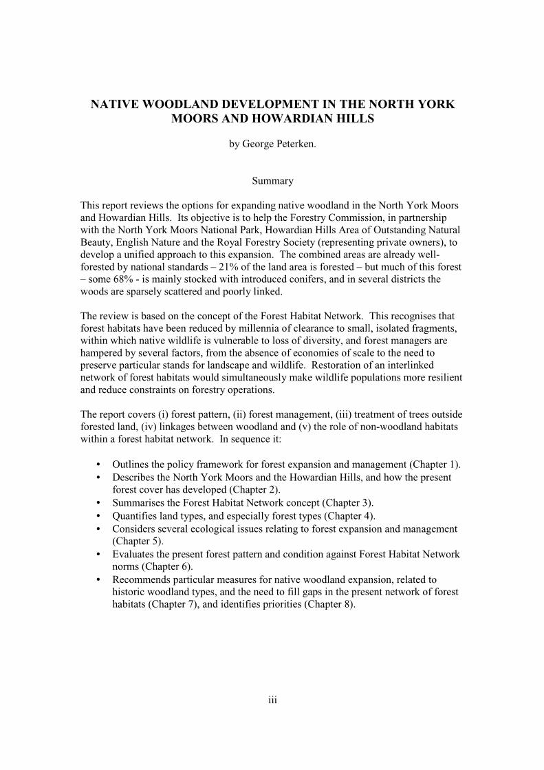
Plate 1.Wood-pasture along the Rye above Hawnby Bridge, with coppiced alder lining a tributary. This semi-woodland landscape was probably far more widespread in earlier centuries. In the background, North Bank Wood (to the left) and Coomb Hill (to the right) represent the closed-canopy woodlands - respectively semi-natural and plantation - that replaced open woods in recent centuries.
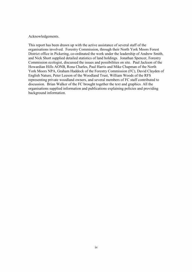
Plate 2.Former alder coppice between Lodge Hag and Wath Wood in the southern part of Hovingham Parish, Howardian Hills. This is part of a riparian corridor rich in semi-natural woodland, fen and unimproved grassland that is grazed by cattle

vi
This page is intentionally blank
.
1
1. INTRODUCTION
1.1. Objective of report The North York Moors is a unique landscape. The scenery has much in common with the uplands of western Britain, but it lies on the eastern seaboard on geological strata that elsewhere give rise to lowland scenery. The moorlands have more in common with lowland heaths of southern England and north-east Scotland than the oceanic vegetation of western Britain. The Tabular Hills clearly have a lowland ecological character, but the sharp relief and concentration of woodland on their high slopes is an upland pattern. The North York Moors National Park has a deserved reputation as a very well wooded region. Within it, Forestry Commission manages some exceptionally large and diverse holdings for timber, recreation, nature conservation and other objectives, and several private estates have substantial areas of plantation under management. The Howardian Hills AONB, which adjoins the NYMNP, has a predominantly eastern lowland character, but it is also well wooded by national standards. This report has been commissioned by the Forestry Commission in partnership with the North York Moors National Park (NYMNP), the Howardian Hills Area of Outstanding Natural Beauty (HHAONB), English Nature (EN) and the Royal Forestry Society (RFS) representing private owners. Its objective is to help the partners develop a unified approach to native woodland restoration and expansion within the NYM and HH by reviewing the issues and proposing measures. Geographically, the report concentrates on the NYMNP and HHAONB, which constitute most of English Nature’s Natural Area 17, North York Moors and Hills. The external relationships of forest land within this study area to a wider network of forest habitat are also briefly examined. 1.2. Approach This review is based on the developing concept of the Forest Habitat Network (FHN). The network approach recognises that forest habitats in Britain have long been greatly reduced and fragmented; that the resulting ecological isolation of forest species has damaging effects on many elements of biodiversity; and proposes that these impacts can and should be mitigated by expanding and re-connecting forest habitats. A very substantial expansion of forest habitats has taken place in the NYM since 1919, but this has had only limited success in re-establishing a network of forest habitats. The network approach requires that individual woods and properties be viewed in context, i.e., as part of the overall pattern of forest habitats, and of the whole landscape.
2
It also requires that some aspects of the existing landscape be quantified as a basis for assessing the present amounts and pattern against general thresholds. There is a large and rapidly expanding international literature on habitat fragmentation, ecological isolation and approaches to restoring networks of habitats. My contributions with others include a general statement for Scotland (Peterken et al 1995), reports on the Cairngorms (Ratcliffe et al 1998), Middle Clyde Valley (Peterken 2000a) and the district around Loch Sunart (Peterken and Worrell 2001), and a general review for WWF (Peterken 2002). Application of the concept in the English lowlands is considered in Peterken (2000b). A conference on large-scale forest conservation was held at Herriot-Watt University, Edinburgh, in 2000, the proceedings of which will be published by the Forestry Commission. 1.3. Policy framework. Recent policy statements by the main partners involved in the NYM/HH all endorse the retention of existing woodland and expansion of woodland, especially native woodland. The following statements have been extracted from recent published pronouncements. 1.3.1. Forestry Commission The England Forestry Strategy (Forestry Commission 1998) endorses the concept of a forest habitat network in the following terms (p.23): “Over 20 per cent of our woodlands are of ancient and semi-natural origin. Many of these are fragments of historically more extensive woodlands. One of the consequences of this fragmentation is that their continued ecological viability is threatened. One way of overcoming this is to restore ancient semi-natural woodlands on the nation’s forest estate. A priority will be to work towards reversing this fragmentation by encouraging the creation of new native woodlands located to create more viable woodland units. Using locally native trees and shrubs helps to conserve the ecological value of native woodlands.” Several programme actions explicitly implement elements of forest habitat network development, in particular:
• Review the effectiveness of the existing measures for protecting ancient semi-natural woodlands and, if necessary, introduce new measures for giving them added protection. This safeguards the base from which an ecological network can be developed.
• Target grants through the Woodland Grant Scheme to reverse the fragmentation
of existing native woodlands, conserve priority species, and help with the preparation of management plans for semi-natural woods. Grant applications that would expand existing woods above certain threshold areas are now preferred, other things being equal.
3
• Create new woodlands along transport corridors as part of a programme of
environmental improvements. This would generate long-distance links in a forest network.
• Promote a network of forest tracks suitable for cycling as part of the National
Cycle Network and our Integrated Transport Policy. Insofar as the cycleway network and new woodland creation are mutually reinforcing, this will help to generate long-distance links.
• Give priority to acquiring freeholds of leasehold land in areas close to centres of
population, particularly in the Community Forests and the National Forest, when there is a shortage of existing woodland access. This reinforces work already well under way to generate Core Forest Areas.
• Support research to improve understanding of the value of the environmental
benefits of trees, woodlands and forests and the environmental processes that they perform, particularly in relation to aerial and water-borne pollution. This hints at reinforcing the links between woodland and watercourses, partly as a buffer against pollution, thereby generating a natural pattern of riparian links in a network.
• Introduce long-term plans to guide the management of woods and forests. This
would help maintain the “network within the network” – i.e., a beneficial distribution of age-classes throughout a developing forest network.
More generally, the England Forestry Strategy has several elements that can facilitate forest network development indirectly. Thus, there will be support for research into the implications of CAP reform for the transfer of land from farming to forestry. Large-scale thinking is manifested in support for strategic development of woodland resources (sustained timber production, support for craft uses, etc), the promotion of forestry through land-use planning, support for incorporating forestry within the work of Regional Development Agencies, and support for highlighting forestry within regional and national planning guidance. Support for new urban forestry initiatives and promotion of forestry as a means of restoring waste and quarried land would improve links between urban greenspace and a rural forest network. 1.3.2. North York Moors NP The NPA produced a Management Plan in April 1998. Section 2.5 (annex 1) gives nine objectives relating directly to trees woodland and forestry:
1. To maintain and enhance the nature conservation value of ancient semi-natural woodland.
4
2. To maintain and, where possible, restore or enhance the nature conservation value and semi-natural characteristics of ancient replanted woodland sites.
3. To improve the environmental quality and maintain productive potential of recent
plantation forests through a multi-purpose forestry approach.
4. To encourage the expansion of existing woodland and the establishment of new woodland in appropriate locations where the special qualities of the National Park will be enhanced.
5. To protect individual trees of amenity and conservation value and to encourage
their planting as new features as well as replacements.
6. To protect archaeological interest within existing forests and woodland, and to ensure that archaeological sites are protected and managed where new planting is proposed.
7. To raise awareness and understanding of the conservation, recreation and
economic importance of trees, woodland and forestry.
8. To safeguard and enhance opportunities for recreation which are appropriate to the location, compatible with the special characteristics of the woodland and involve minimal conflicts between users.
9. To encourage active management of broadleaved woodland for conservation,
amenity, sporting and forestry purposes. Inevitably, other objectives impinge on woodlands, and vice versa. In particular, the following objectives relating to:
• Local distinctiveness (Landscape change 3, 3) • Traditional features of farmed landscape (Farmed land 1) • Mosaic of semi-natural habitats (Farmed land 2) • Coastal woodland (Coastal 1) • Quality of surface water and groundwater (Freshwater 1) • River corridor landscapes (Freshwater 3) • Freshwater, wetland and associated habitats (Freshwater 5). • Extending moor edge woodlands (Moorland 5)
1.3.3. Howardian Hills AONB The Joint Advisory Committee of the AONB approved a management plan in November 1997. This identified ten objectives relating to forestry and woodland:
1. Resist permanent loss of any significant area of woodland to other land uses.
5
2. Maximise opportunities for planting and economic management of broadleaved timber.
3. Support use of mixed conifer/broadleaved plantations, in appropriate
circumstances, as an economic means of achieving a long-term broadleaved crop. Encourage wider, more integrated use of broadleaved species in conifer plantations, to increase visual and ecological diversity.
4. Promote use of natural regeneration techniques in remaining areas of semi-natural
woodland, where conditions are suitable.
5. Encourage restoration to native broadleaved woodland in key ancient replanted woodlands identified as local nature conservation priorities.
6. Establish a set of broad woodland management guidelines to assist woodland
owners and Joint Advisory Committee partners in decision-making during planning of woodland management operations and forestry consultation procedures.
7. Encourage a multi-purpose approach to woodland management.
8. Encourage preparation of woodland management plans for sensitive areas, and
integrated forest design plans for larger blocks of woodland.
9. Develop new forms of local funding to ensure woodland owners have access to a range of financial incentives, which enable them to support AONB objectives without suffering economic disadvantage.
10. Encourage new areas of farm woodland where this would be in keeping with the
character of the landscape and would not conflict with other interests. Here, too, other objectives impinge on forest habitats, in particular:
• AG3, relating to the conservation of habitats in farmland • NC3, relating to ancient, semi-natural woodland • NC2-7, relating to all habitats, including semi-natural grassland and wetlands.
1.3.4. English Nature The NYMNP and HHAONB form the major part of English Nature’s ‘North York Moors and Hills Natural Area’ (Morley 1997). The three general objectives for this and other areas are (i) to manage and restore characteristic wildlife habitats and species, (ii) maintain and restore rare, declining and extinct species, and (iii) maintain the diversity of geological interest.
6
The first objective relates to all semi-natural habitats. The statement in relation to woodland reads as follows: Maintain existing semi-natural and ancient broadleaved woodlands by appropriate management, especially control of grazing. Restore where lost native broadleaved woodlands (e.g. oakwoods) by planting or natural regeneration using local, native stock, particularly where adjacent to existing woodlands and where links between woods are made. The planting of non-native species in areas of conservation interest should be limited, and control of these species where they occur in existing woodlands of nature conservation value should be undertaken (e.g. by thinning and felling). Coniferous woodlands should be managed to optimise their value to wildlife, with sympathetic coupe retention, retention of permanent open areas, ride widening, and the clearance of trees from around watercourses. The most important area of parkland and veteran trees should be identified, and managed sensitively to provide suitable habitats for associated species (e.g. woodland invertebrates) by encouraging the presence of standing and fallen dead wood. Woodland plant and animal communities (especially woodland birds) should be encouraged by woodland management catering for their needs.
7
2. DESCRIPTION This chapter sets the scene, summarises woodland history, and recognises six landscape zones that are used for later analysis. 2.1. Geology, Land Form, Drainage and Soils The NYM is the most southerly mass of upland scenery on the eastern seaboard of England. Its core is an exposure of Jurassic sandstone forming a plateau that rises to 453 m (1489 feet) and generally declines in altitude to the east and south. This supports the heather moorland that gives the district its name. Somewhat older Lias shales and ironstones have been exposed below the sandstone scarp to the north, and in the basins of several valleys within the moors. To the south is a second plateau formed from Jurassic limestones, which slope gently down to the Vale of Pickering. Between the sandstone and limestone is a narrow exposure of Oxford clay that has eroded to leave a limestone scarp facing the moors. To the west and north, glacial drift has been deposited over Jurassic strata (summarised from Spratt and Harrison 1989). This is a land of plateaux, scarps and deeply incised rivers. To the north the Esk and other smaller rivers drain through drift into the North Sea. The southern moors drain south through deep, narrow valleys cut through limestone into the Derwent. The western scarps overlooking the Vale of Mowbray are particularly dramatic. Here, exposures of limestone above sandstone run south as the Cleveland and Hambleton Hills, then extend beyond the boundary of the NYMNP to form the Howardian Hills. The latter extend as far as the Kirkham Gorge where, through a quirk of glacial history, the Derwent flows away from the coast and ultimately into the Humber. Table 2.1. Soils within the North York Moors and Howardian Hills. Summarised from Soil Survey (1974). Area
Dominant soil group
Description
Moorland core Stagnohumic gleys Deep to shallow, loamy or clayey, often stony, with impeded drainage. Some deep peats and peaty-topped soils.
Moorland valleys Stagnogleys Loamy or clayey soils, locally stony, with impeded drainage, associated with better-drained mainly loamy soils, locally shallow over rock, formed from shale and sandstone.
Esk valley Stagnogleys Loamy or loam-over-clay soils, often stony, with impeded drainage, associated with peaty-topped soils and better-drained, mainly loamy soils, formed from boulder clay.
Coastal plain Stagnogleys Loamy and loam-over clay soils, locally stony, with impeded drainage, associated with better-drained, loamy soils, formed from boulder clay.
Tabular Hills and Howardian Hills
Brown earths and calcareous soils
Well-drained moderately deep loamy soils, locally stony, associated with shallow soils over limestone.
8
The soils within the NYM and HH fall into three broad groups (Table 2.1). The moorland has strongly acid, base-poor, peaty stagnogleys, whereas the Tabular and Howardian Hills have neutral-alkaline brown earths. Intermediate between these are the soils of the moorland valleys and coastal plain, which are moderately acid, moderate in base-status, and often poorly drained. 2.2. Components of the landscape The landscape is commonly regarded as ‘man-made’, but it evolved from a natural landscape and retains some natural elements (Spratt and Harrison 1989). The evolutionary processes started with Mesolithic hunter-gatherers and continued for 6500 years. The broad distribution of moorland, woodland and farmland developed in prehistoric times, and much of the modern farmland pattern was in place by 1300. Woodland This is the original vegetation. It once covered all the land, save for sea cliffs and major watercourses, but substantial portions were probably fairly open, where poor drainage and lush ground vegetation inhibited tree regeneration and growth, and grazing animals sustained herbaceous glades. Most of this woodland was cleared in prehistory, leaving remnant woods - now known as ancient woods - mainly on steep ground with thin soils, and locally on wet ground and streamsides. Most of this wooded ground lies between the moorland and the farmland, or within farmland on narrow, deeply incised valleys The ancient woods were managed by two forms of traditional management, between which there were several intermediate forms. Most were managed as coppices, with oak (rarely ash) standards over hazel, ash, alder, wych elm, etc. coppice, providing small wood, timber and other products for local use. Alternatively, a few woods were used as wood-pastures, where scattered oaks grew to great age in a matrix of pasture. Attrition of ancient woods continued in historical times, but new woodland was also created by planting on open ground or when trees naturally colonised vacant territory. These secondary woods differed from ancient woods in several respects: in particular, introduced tree species were common and often dominant, and most were treated as high forest. The distinction between ancient woods and the recently-originated secondary woods was clear enough in 1800 (Jones 1961), but during the 20th century it broke down because traditional systems fell into disuse and many ancient woods were transformed by planting. In both the NYM and HH, the majority of replanted ancient woods were stocked with conifers.
9
Surviving natural elements:
• The ancient woods as remnants of the original forest cover. At least parts of these woods are assumed to have been wooded continuously for several thousand years. Populations of woodland plants and other wildlife have been able to survive within these woods since the time when most of the landscape was wooded.
• The ‘semi-natural’ mixtures of trees and shrubs in ancient woods are assumed to
be site-native. Despite centuries of management, few if any trees and shrubs were planted. Stand composition therefore reflects mainly natural factors. This feature has been much attenuated in ancient woods converted to plantations.
• The soils and topography within ancient woods probably remains close to natural.
Moorland Moorland was created from woodland by grazing and burning. It originated in the Mesolithic and was extended and reinforced by millennia of low-intensity pastoral use. It comprises a mosaic of heather heathland, bracken on deeper soils, grassland, mires of cotton grass and Sphagnum, and flushes running down to small streams. The dominance of heather over other elements was enhanced by the rise of burning associated with grouse shooting after 1850, and locally by earlier attempts at drainage. Most moorland occupies base-poor soils at the higher altitudes. It is treeless by definition, but capable of developing into birch – oak woodland with bilberry and bracken ground vegetation. Settlements have been very limited above 240m during historical times. Surviving natural elements:
• Moorland vegetation comprises an assemblage of native plant species that have occupied the ground for millennia. They presumably originated as species of woodland ground vegetation, poorly wooded mires, heathy glades and perhaps coastal cliffs.
• The mosaic of vegetation types reflects natural variation in soils and topography,
modified by pastoral usage.
• Soils have not generally been cultivated, i.e., they have developed by natural processes. However, they have been transformed by the consequences of woodland clearance and extractive usage, and are now much less fertile and more prone to erosion than they would have been naturally.
10
Farmland Enclosed farmland occupies the fertile, more tractable land generally at lower altitude. It was derived from woodland and – locally – marsh by millennia of clearance, drainage, cultivation and grazing. The main concentrations of farmland were undoubtedly established in prehistoric times, but the margins of farmland were extended during historical periods. Moorland fringes were colonised by ‘intakes’ during the Middle Ages. During the 17th century there were continual extensions of farmland into woodland and waste. Open fields and common pastures were enclosed at various dates, and continued during the 18th and 19th century Parliamentary Enclosures. The pattern of land use within farmland evolved over the centuries. Although much of the pattern of settlement and field boundaries had developed by 1300, enclosures continued to be divided, merged or altered. The present boundaries are a mixture of hedges and walls. Whilst some hedges originated as margins of woodland that were later cleared, many are quickset hedges planted in the 18th and 19th centuries. Walls date from a range or eras from the Middle Ages to the 20th century. Farmland was cultivated or used as pasture and/or meadow. The balance between these constantly fluctuated, but a broad pattern was maintained of meadows and winter pasture on low, often wet ground, arable on middle ground with deep soils, rough pasture on higher slopes, that were usually steep with thin soils, and more rough pasture on plateau ground remote from settlement. This traditional pattern has been largely lost during the 20th century by the massive extension of arable and sown leys on almost all types of ground. Surviving natural elements:
• Surviving traditional (‘semi-natural’) pastures and meadows represent assemblages of site-native plants derived ultimately from natural woodland ground vegetation, marshes, riparian vegetation, and open woodland/scrub on rock outcrops and cliffs. Individual pastures and meadows may have been cultivated in the past, but until recently they were reconstituted from seed taken from nearby vegetation.
• Trees and shrubs in hedges, walls and other boundaries are generally site-native,
though many have certainly been planted. Neglected plots and corners develop into scrub woodland by natural succession.
• Watercourses through farmland are commonly incised into the land and lined with
site-native trees. Habitat conditions in their immediate vicinity may be close to original. The configuration of small streams has been only moderately altered. Water quality and flow regimes have been influenced by farming, but may still be fairly natural.
11
Changes between the main components Although the present distribution of woodland, moorland and farmland was probably established by Roman times, fluctuations between the main landscape components were commonplace, and can still be detected in the modern landscape. Examples of change in recent centuries include:
• Retreat of farming from former intakes and moorland fringe fields, leaving fields of rushes, bracken, and scattered scrub.
• Development of substantial amenity parkland around large country houses,
usually at the expense of mixed farmland (and occasionally whole villages). The transformed land has taken the form of pastures, planted woods, scattered planted trees, ornamental lakes.
• Extension of farmland onto former common moors and pastures on the lower and
more fertile plateau land.
• Substantial afforestation from the 18th to 20th centuries, mostly by planting on moorland and rough pastures.
• Ploughing and reseeding of moorland under the stimulus of 20th century subsidies
and techniques.
• Intensification of farmland use by ploughing, draining, fertilising and reseeding, combined with failure to maintain the succession of boundary trees.
2.3. Development of the modern forest cover 2.3.1. Prehistoric Knowledge of the prehistoric forest cover provides one baseline against which the ‘natural’ forest cover can be assessed, and information on the course of forest clearance from which the degree and duration of ecological isolation can be estimated. Atherden (1998), Simmons (1995) and Simmons et al (1990) have brought together evidence for the North York Moors, derived from pollen and archaeological studies. Key points include:
• The forest cover was already being disturbed by Mesolithic people, perhaps as early as 7000BC. Forest composition continued to change thereafter, but it is impossible to be sure of the relative importance of people and natural factors.
• From 4650BC, deciduous woodland was characteristic of the moors (sens.lat.).
The main genera were oak, hazel, alder, elm and birch, with some ash, lime, sallow and pine. Beech also appears to have been present locally by 3800BC. The distribution of trees within the woodland is not well known, but pine was
12
more likely to have persisted on the moors, and lime, elm and beech were more likely to have been present at lower altitudes on base-rich soils.
• The woods were not closed. Open habitats appear to have been widely scattered,
perhaps more on the mires, moors and valley bottoms than on the slopes. Openings could have been maintained by large herbivores, such as deer and primitive cattle.
• Clearance on the moors was widespread after 4300BC. It allowed moorland soils
to leach and eventually develop into heathland. Elsewhere, clearance was later: the first major clearance at Wheeldale Gill and Fen Bog has been dated to 2200-1400BC. There seems to have been some woodland recovery between 420 and 900AD, which leaves open the probability than many ancient woods are actually secondary.
• Woodland exploitation started in the Mesolithic. Iron smelting started 500BC-
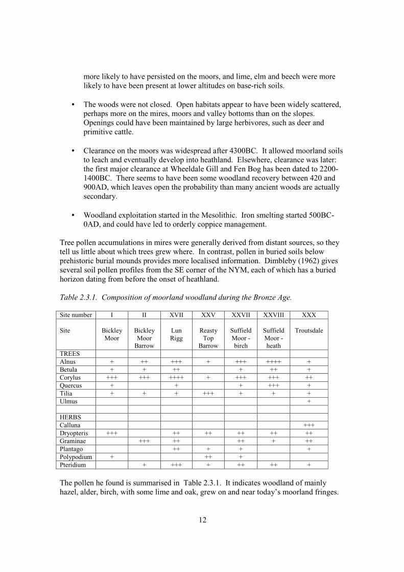
0AD, and could have led to orderly coppice management. Tree pollen accumulations in mires were generally derived from distant sources, so they tell us little about which trees grew where. In contrast, pollen in buried soils below prehistoric burial mounds provides more localised information. Dimbleby (1962) gives several soil pollen profiles from the SE corner of the NYM, each of which has a buried horizon dating from before the onset of heathland. Table 2.3.1. Composition of moorland woodland during the Bronze Age. Site number I II XVII XXV XXVII XXVIII XXX Site
Bickley Moor
Bickley Moor
Barrow
Lun Rigg
Reasty
Top Barrow
Suffield Moor - birch
Suffield Moor - heath
Troutsdale
TREES Alnus + ++ +++ + +++ ++++ + Betula + + ++ + ++ + Corylus +++ +++ ++++ + +++ +++ ++ Quercus + + + +++ + Tilia + + + +++ + + + Ulmus + HERBS Calluna +++ Dryopteris +++ ++ ++ ++ ++ ++ Graminae +++ ++ ++ + ++ Plantago ++ + + + Polypodium + ++ + Pteridium + +++ + ++ ++ + The pollen he found is summarised in Table 2.3.1. It indicates woodland of mainly hazel, alder, birch, with some lime and oak, grew on and near today’s moorland fringes.
13
The presence of grasses and plantains suggests open woodland, though the presence of male fern and polypody suggests some closed woodland. Taken together, there seems to have been a good deal of variation, i.e., the woodland was patchy, possibly due to the activities of the prehistoric people who buried the soils below burial mounds. 2.3.2. Historic Wightman (1968) provides an excellent source of information on the amount and condition of woodland in the early Middle Ages, though his study area omitted the northern and coastal parts of the NYM and the SW half of the Howardian Hills. There was an arc of continuous (i.e. closed canopy) woodland around the Tabular Hills and round to the northern slopes of the Howardian Hills. These woods were confined to the valleys and steep ground, the plateaux being occupied by grassland, and most seem to have been coppices. The only exceptions were woods in manorial parks at Helmsley, Kirkbymoorside and Blansby, and these were presumably wood-pastures. The moorland valleys were thinly wooded, apparently with wood-pasture in the process of being assarted, i.e., enclosed from the waste, and the moors were covered in heather and bracken. A limited set of references suggests that the lowland grassland areas contained thorn, gorse, bracken and areas of rush and sedge. Specific references to individual woods commonly coincide with woods still present on the modern map. Likewise, some of the wood-pastures survive as a scatter of trees on valley-side grazings (see section 2.4). The condition of some woods in the 17th century is indicated by the 1642 survey of the Helmsley estate (Gulliver 1998), which extended from around Helmsley itself into Bilsdale. The principal feature was the variety of treatment and condition within the ancient woods: some were treated as short-rotation (7 years) coppice, others as longer-rotation coppice-with-standards, some as high forest, and a group in East Park apparently as long-rotation high forest. In some woods the principal value was in the underwood, but others consisted almost wholly of ‘dodderells’, i.e. over-mature trees, including pollards, and in most woods the range of tree quality was very wide. The main tree species were oak and ash, the former being the more valuable. Interestingly, the herbage was valued in a few woods, though not highly, and instances of damage to underwood by ‘beasts’ were recorded. Part of the survey gives a precise insight into the stock of farmland trees. In 82 farms in Bilsdale, there were 7860 trees. By far the majority were oaks, mainly medium quality trees (28%) and dodderells (23%). However, sapling oak (14%) and ash (15%) were well represented, indicating (i) that the succession of farmland trees was being maintained, and (b) that most of the ash must have been cut young. Traditional management in the late 18th century is described by contributions to the reports of the Board of Agriculture. E.W. Jones (1961) gives a summary of Marshall’s (1788) record: ‘The springwoods of the valleys north of the Vale of Pickering were regenerated by coppicing, but were grown on a longer rotation than usual for simple coppice (40-50 years or more) and thinned at approximately 10-yearly intervals, thereby yielding fencing material.’
14
In a later digest, Marshall (c.1800) summarises the method of planting of new woodlands by one local landowner: ‘Francis Cholmeley (Mr Cholmeley of Bransby on the Howardian hills) has found that the timber of larch is very durable for every purpose: he has used it for gate-posts, and has had some of them taken up after having been in the ground eleven years, which, he says, were as sound and perfect as when cut out of the tree. The plantations already finished have a pretty large mixture of firs and other trees; but the larch being so much more valuable, thriving so well, and being such quick growth, he intends, in future, chiefly to plant it.’ The nursery technique is described: young larch were usually planted out at 4 years, after two transplantings in the nursery. John Tuke (1800) gives important details of how semi-natural woods were managed 200 years ago. Their ‘spontaneous growth’ was oak, ash and ‘broad-leaved or witch elm’, supplemented by birch and alder on the uplands. The system recommended was a form of simple coppice on long rotations with different kinds of mid-rotation thinning. Many woods of the North Riding were managed by the “spring-felling” system. The stand was clear felled, cutting as close as possible to the ground, taking care to leave the stool round and smooth ‘to prevent the lodgement of wet’. New growth came from old stools and ‘the seed scattered on the ground’ [presumably this refers to natural scattering, not deliberate broadcasting]. Cattle were excluded, growth was occasionally thinned, and after 30 years the stand was felled again. This system was suitable for oak, ash, and wych elm, the wood produced serving ‘many purposes of husbandry and country use’. Other woods, including several large woods, were treated as coppice with standards. ‘In going over their woods about every 20 years, [some] raise a constant succession of timber, by leaving every time a certain number of the most likely young trees on each acre, and a certain number of every preceding thinning; so that at the same time they leave a considerable number of trees of 20 years old, they leave also a certain number of twice, three times, four times or upwards of that age; fewer of each in proportion to their age’. This method seemed to raise the best trees, and the greatest quantity of timber ‘because of wood, suffering little alteration, affords the most uniform and regular protection to the growth of the trees; and probably is the most profitable mode of managing woodlands’. The only disadvantage was the extra trouble needed when felling: damage was minimised by cutting off the crowns first. ‘When woods are suffered to grow to their full size, it is the practice of some to have them weeded, that is, thinned of the smaller, and too numerous trees and underwood, as often as these acquire a size sufficient to make them useful for rails, stakes, or bindings for hedges, or other similar purposes, which is generally once in about seven years; at last
15
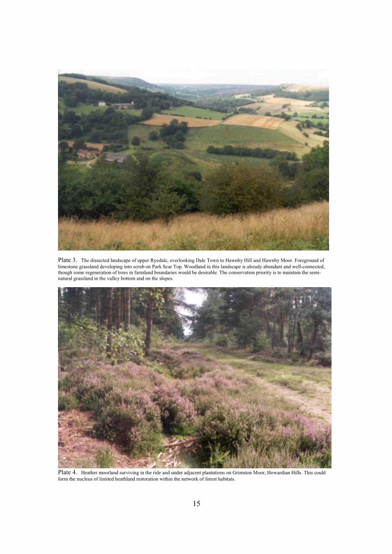
Plate 3. The dissected landscape of upper Ryedale, overlooking Dale Town to Hawnby Hill and Hawnby Moor. Foreground of limestone grassland developing into scrub on Park Scar Top. Woodland in this landscape is already abundant and well-connected, though some regeneration of trees in farmland boundaries would be desirable. The conservation priority is to maintain the semi-natural grassland in the valley bottom and on the slopes.
Plate 4. Heather moorland surviving in the ride and under adjacent plantations on Grimston Moor, Howardian Hills. This could form the nucleus of limited heathland restoration within the network of forest habitats.

16
This page is intentionally blank
17
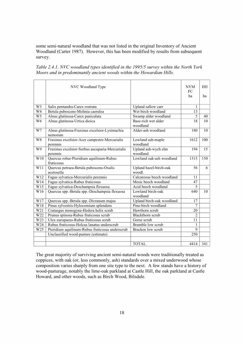
the whole wood, when arrived at maturity, is cut down at the same time, and again trained in a similar manner for timber. This is the same as .... spring felling, only continued for a greater number of years.’ Tuke also records that some forms of coppice-with-standards were not successful. ‘Instances may be seen in this district of that mode of management, of leaving at certain distances, when the timber and underwood are cut down, the thriving young trees, which so left, are very properly called ‘wavers’ ..... These starved and deserted orphans rarely make any progress ..... : they become stunted in their growth, and generally arrive at a premature end. Had [they] been cut down with the rest of the wood, the shoots from them would probably have formed the future timber ..... This is probably the worst mode of managing woodlands, the one that most seldom succeeds, and which is now going fast out of use’. Tuke also gave a comment by M.G.Steele that implies woodland destruction by farmers: ‘Besides the aridity with which wood has been, and continues to be, cut down by the generality of its owners, ninety-nine farmers in one hundred are its most mortal enemies! – they study its destruction with more than gothic ignorance and barbarity’. Conifer plantations were already familiar in the 18th century, and may well have diminished in number and extent towards by end of the 19th century. The Ordnance Survey maps of c.1920 (Popular Edition, sheets 16, 23) nevertheless show several substantial conifer plantations, for example, at Westonby and Egton Low Moors, Coate Moor near Kildale, Park Plantation near Ingleby Greenhow, Cloughton Plantation, Wykeham Low Moor and Sand Dale. The revival of forestry after 1919 provided incentives for new planting: after1945 much of the south-eastern moorland was afforested by the Forestry Commission, and private owners converted numerous ancient woods to plantations. The Bilsdale Survey shows that farmland traditionally contained many trees – mostly oak and ash – of a wide range of ages and condition. The customary succession of use and renewal in association with hedge maintenance appears to have continued well into the 20th century. Recently, use and renewal appear to have been less systematic, and there has probably been a net loss of farmland trees, whilst the survivors have grown large. 2.4. Ancient woodlands The ancient woods of the study area cover a wide range, from wet sallow and alder woods, through flushed woodland on mineral soil to dry woodlands on thin soils over sandstone or limestone scarps. A survey of over 4000 ha of North York Moors woodlands carried out in 1994/5 found that the great majority fell within the range from alder-ash woods on mineral soils, through a variety of oak-ash-hazel woodlands to acid birch-oak woodlands (Table 2.4.1), and this was confirmed for FC holdings by Emma Goldberg (2000)(Table 4.7.1). The range within the Howardian Hills is more limited, but concentrated within the same range of types. The NYMNP survey actually included
18
some semi-natural woodland that was not listed in the original Inventory of Ancient Woodland (Carter 1987). However, this has been modified by results from subsequent survey. Table 2.4.1. NVC woodland types identified in the 1995/5 survey within the North York Moors and in predominantly ancient woods within the Howardian Hills.
NVC Woodland Type
NYM
FC ha
HH
ha
W3 Salix pentandra-Carex rostrata Upland sallow carr 1 W4 Betula pubescens-Molinia caerulea Wet birch woodland 13 W5 Alnus glutinosa-Carex paniculata Swamp alder woodland 5 40 W6 Alnus glutinosa-Urtica dioica Base-rich wet alder
woodland 18 10
W7 Alnus glutinosa-Fraxinus excelsior-Lysimachia nemorum
Alder-ash woodland 180 10
W8 Fraxinus excelsior-Acer campestre-Mercurialis perennis
Lowland ash-maple woodland
1612 100
W9 Fraxinus excelsior-Sorbus aucuparia-Mercurialis perennis
Upland ash-wych elm woodland
194 15
W10 Quercus robur-Pteridium aquilinum-Rubus fruticosus
Lowland oak-ash woodland 1315 150
W11 Quercus petraea-Betula pubescens-Oxalis acetosella
Upland hazel-birch-oak woodl.
56 6
W12 Fagus sylvatica-Mercurialis perennis Calcareous beech woodland 11 W14 Fagus sylvatica-Rubus fruticosus Mesic beech woodland 47 W15 Fagus sylvatica-Deschampsia flexuosa Acid beech woodland 5 W16 Quercus spp.-Betula spp.-Deschampsia flexuosa Lowland birch-oak
woodland 640 10
W17 Quercus spp.-Betula spp.-Dicranum majus Upland birch-oak woodland 17 W18 Pinus sylvestris-Hylocomium splendens Pine-birch woodland 7 W21 Crataegus monogyna-Hedera helix scrub Hawthorn scrub 20 W22 Prunus spinosa-Rubus fruticosus scrub Blackthorn scrub 2 W23 Ulex europaeus-Rubus fruticosus scrub Gorse scrub 11 W24 Rubus fruticosus-Holcus lanatus underscrub Bramble low scrub 1 W25 Pteridium aquilinum-Rubus fruticosus underscrub Bracken low scrub 9 Unclassified wood-pasture (estimate) 250 TOTAL 4414 341 The great majority of surviving ancient semi-natural woods were traditionally treated as coppices, with oak (or, less commonly, ash) standards over a mixed underwood whose composition varies sharply from one site type to the next. A few stands have a history of wood-pasturage, notably the lime-oak parkland at Castle Hill, the oak parkland at Castle Howard, and other woods, such as Birch Wood, Bilsdale.
19
Samples recorded in the 1970s in Ryedale and the Forge Valley can be used to illustrate the range of conditions found in the woods of the Tabular Hills (Table 2.4.2). Although this is a very small and unrepresentative sample, some important features emerge:
• Very wide range of soil base status (pH 3.9-7.9). • Substantial differences across very short distances (samples in Ashberry Wood). • Wide range of drainage conditions. • Substantial diversity of stand constituents, even within single woods. This is
matched by diversity of ground vegetation. • Both oak species and hybrids present, with Q.petraea much commoner on
strongly acid soils. Table 2.4.2. Summary of conditions recorded by GFP in sample NYM ancient woods in 1972 and 1977. GFP sample
Wood
NGR
pH
Texture
Drainage
Stand (stds/coppice)
Oak spp
553 Cliff 539886 7.9 L Excessive Oak, ash/hazel, maple Qr 550 Ashberry 570846 7.7 CL Free Oak/hazel, elm, ash, maple Qr 320 Ashberry 569847 5.8 SCL Free Oak (ash,elm)/hazel Qr 552 Spring 561848 4.2 CL Impeded Oak, birch Qp, Qr 551 Reins 566846 4.1 SC Very poor Birch, formerly oak HF Qr x Qp 321 Ashberry 568846 3.9 SL Free Oak-birch HF Qp, Qr 322 Scarwell 982874 6.3 Si Flooded Alder coppice None 324 Cliff 984874 4.9 SL Free Elm-lime Qp 323 Scarwell 983571 4.6 SL Free Oak/hazel (oak) Qr
The list of ancient woods in the Inventory was based on early 19th century maps. Earlier maps and records would show that “ancient woods” as a class encompasses a variety of histories. A good example of this come from a boundary dispute at Old Byland, for which Christopher Saxton prepared a map in 1598 (PRO MPB 32). Ashberry Wood was as clear then as now, and likewise woodland running north to Oxendale and west to Callister Wood. These were shown as dense woods, presumably coppices, but the woods north of Old Byland along Birk Bank and westwards Sleddale were fragmented and shown as open woodland, presumably wood-pasture. Much of the woodland west of Caydale Mill was not then present, i.e., it is secondary. On the evidence of this map, the Inventory is broadly correct, but the woods we treat as ‘ancient’ include not only traditional coppices, but also extensive wood-pastures and tracts of older secondary woodland. The fragments of wood-pasture on the slopes below Mount Pleasant Farm appear to be a relict of the 1598 wood-pasture. 2.5. Landscape Zones The NYMNP is a large area with several distinctive landscapes between which the amounts, kind and pattern of woodland varies greatly. The HHAONB is more of a piece,
20
but the Kirkham Gorge is distinctive, and there are significant differences between plateau and dales. Consideration of a FHN must take account of this variation. An attempt has been made to recognise zones within the NYM that draw out the district-scale distinctions (See Figure 2.5). They have been based on geology, topography, drainage, and the pattern of woodland and farmland trees, and conform reasonably closely to the zones recognised in Measuring Change (NYM, 1998). Zone 1. Moorland This is the central moorland associated with Jurassic sandstones and shales. It takes the form of an extensive upland plateau, that is largely contiguous from east to west, strongly dissected by headwater streams draining south to the Derwent and in the north to the sea. Large detached moorland blocks occur west of Bilsdale and north of Eskdale, and in addition there are several smaller blocks detached but essentially similar to the core moorland. The highest ground lies in the north and west part of the core moorland. The moorland zone has long included very few settlements. It is largely unenclosed, but small intakes of farmland have persisted, and some of the valley farmlands extend onto the moorland plateau. In recent times, parts of the moorland have been ploughed, fertilised and reseeded as leys. The vegetation is a largely treeless mosaic of heath, bracken, mire and acid grassland, grazed by sheep and extensively burned to maintain habitats for grouse. Small, isolated patches of native woodland occur in some headwaters, and conifer plantations have been established on the margins and more widely in the south-east. Trees have spread thinly onto the moorland fringes. Only one large plantation has been created in the core moorland, at Wheeldale, where it has almost completely surrounded one of the largest moorland native woods. Conservation of the moorland is a primary aim of the NPA. To a substantial degree, therefore, the moorland zone must remain a large gap in a forest habitat network. The principal exception is the marginal bracken-dominated ground: here there are opportunities to generate woodland without loss of heathland, and to soften some of the moorland margins. Zone 2. Moorland valleys. These are the broad valleys formed where a basin of Lias shales and ironstones have been exposed within a rim of sandstone moorland. From the east they comprise Rosedale, Farndale, Bransdale and Bilsdale, all of which lie in a matrix of moorland. Upper Ryedale above Hawnby is also included because it, too, lies in a matrix of moorland, though geologically it has more in common with the narrow valleys of the southern hills (zone 5). All these valleys drain south to the Derwent through the southern hills and the vale of Pickering.
21

22
This page is intentionally blank
23
The valleys are deep and broad, with a scatter of farms and small villages, set in a landscape of hedges and walls, with a rim of moorland generally visible on the skyline. Most of the land is farmed as pasture for sheep and, but a small proportion is cultivated. Much of the grass is either sown or ‘improved’, but a few fields remain as rough pasture. Despite the prevalence of farmland, the valleys appear well-wooded, principally because a reasonable stock of mature boundary trees survives from earlier farming eras, and both the incised headwater streams and main rivers are generously lined with trees, scrub and narrow woodlands. Zone 3. Coastal plain and valleys This is the Esk catchment combined with the coastal zone between the moorland and the sea. Much of the zone is and undulating plain formed from alluvium and glacial drift, but the Esk and several small streams have cut deep valleys on their way to the sea, exposing patches of sandstone and shales. The upper reaches of the Esk drain from sandstones, shales and ironstone. Most of the land is farmed as pasture for sheep and cattle mixed with a substantial cultivated area. Towards the coast the farmland is fairly bleak, with only a limited scatter of boundary trees, but it is crossed by deep, well-wooded valleys. The Esk catchment has a higher density of trees and some substantial woods associated with the steeper ground close to the river. Settlement is concentrated along the coastal valleys and several substantial villages within the Esk catchment. Whitby, the largest settlement, has been excluded from the NP. Zone 4. Western fringes A narrow belt of rugged hills runs along the entire western fringe of the NP, and is distinctive enough to be worth recognising as a separate zone. The southern portions are known as the Hambleton and Cleveland Hills, but the zone extends round to the hills above Guisborough. In simple terms, this is the land that can be seen from outside the park to the west and north-west. The common feature of this zone is its topography: it is the scarp where the high plateaux formed by the sandstones and limestones of the moorland and southern hills fall to the low-lying Vale of York to the west. The slopes are formed from sandstones to the south and Lias shales to the north. Most drain to the Ouse, Ure, Swale and Tees, but the hills above Guisborough drain north to the sea. This is extremely irregular terrain, with many large woods on the slopes, mixed with a substantial amount of rough grazing and scrub. It runs down to villages within well-wooded, farmed countryside, some of which has been included within the NP boundary.
24
Zone 5. Southern hills The southern fringes take the form of a sharply dissected belt of limestone and Corrallian grits that slope gently south into the Vale of Pickering, separated from the moors to the north by a narrow belt of Oxford Clay. Under periglacial conditions, the headwaters of the Derwent carved deep gorges and narrow valleys that contrast strongly with the remnants of the sloping plateau between. This is a region of well-appointed villages and large farms. The sparsely-populated limestone plateau is intensively cultivated: many of the former walls have been removed and few boundary trees remain. Towards the Vale of Pickering a higher proportion of the farmland is used as pasture, but much of this has been excluded from the NP. Within the steep-sided valleys, farmland is used as pasture for sheep and cattle. Zone 6. Howardian Hills These are gently undulating hills that extend south-eastwards from the south-western margin of the NYMNP, rising to above 150m near Yearsley, but including much land below 60m on the fringes. Small streams drain north to the Rye and south more directly to the Derwent. Several distinct districts are recognised within the AONB, of which the most distinctive are the upland fringes adjacent to zones 4 and 5 of the NYMNP, and the Kirkham Gorge forming the sough-eastern margin. The pattern of land use is essentially lowland. The landscape is dominated by arable farmland and sown leys, punctuated by well-appointed villages. Woods and other semi-natural habitats exist as islands in a matrix of farmland with a low density of trees. Individual woods are, however, generally large. Ancient woods are concentrated in a belt from Hovingham through Castle Howard to the Kirkham Gorge
25
3. FOREST HABITAT NETWORKS
This chapter summarises the main features of Forest Habitat Networks as they relate to British conditions (FHN). For a more detailed statement, see Peterken (2000, 2002). 3.1. Forest Habitat Networks (FHN) in general. The basic idea behind a FHN is simple enough. Forest habitats and their associated species naturally covered the landscape, but have been reduced by clearance and fragmented into isolated wooded remnants in a matrix of unwooded land. Fragmentation can be reversed by re-creating at least some of the lost habitats, and ensuring that the resulting pattern achieves good links between the components. This is ‘defragmentation’ or, more euphoniously, ’restoring a forest habitat network’. The assumptions underlying a FHN are threefold:
1. that ecological isolation is severe and limiting for wildlife. 2. that, if more woodland were created and a network were to be generated,
populations would expand, ranges would adjust to changing circumstances, and biodiversity would be more resilient.
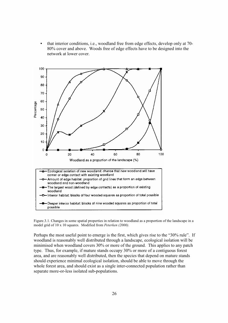
3. that this expansion and greater resilience would be a ‘good thing’. 3.2. The relationship between forested land and the rest of the landscape. FIG 3.1 summarises some the properties of a hypothetical landscape in which woodland is distributed randomly. By reading from left (no woodland) to right (wholly wooded), we can read how the landscape changes as new woodland is added randomly to this landscape. The key points are:
• that new woodland added to a landscape that is 30% wooded or more will almost invariably lie close to existing woodland, i.e., that ecological isolation is minimised if woodland can be increased to at least 30% of the land area, provided it is reasonably well distributed.
• that edge habitats are maximised at about 50% woodland cover, and remain
substantial within the range 20-80% cover.
• that from about 60% cover upwards, woods tend to form the habitat matrix, within which other habitats take the form of islands.
26
• that interior conditions, i.e., woodland free from edge effects, develop only at 70-80% cover and above. Woods free of edge effects have to be designed into the network at lower cover.
Figure.3.1. Changes in some spatial properties in relation to woodland as a proportion of the landscape in a model grid of 10 x 10 squares. Modified from Peterken (2000). Perhaps the most useful point to emerge is the first, which gives rise to the “30% rule”. If woodland is reasonably well distributed through a landscape, ecological isolation will be minimised when woodland covers 30% or more of the ground. This applies to any patch type. Thus, for example, if mature stands occupy 30% or more of a contiguous forest area, and are reasonably well distributed, then the species that depend on mature stands should experience minimal ecological isolation, should be able to move through the whole forest area, and should exist as a single inter-connected population rather than separate more-or-less isolated sub-populations.
27
FIG 3.1. can also be used to characterise the main features of forest elements in a landscape at different ranges of woodland cover:
• Forest cover close to 100%. Natural conditions. Forests would naturally cover the great majority of the north temperate landscape, save for small permanent openings on high ground, large rocky outcrops, large mires and major rivers, and temporary openings where forest had recently been severely disturbed by, say, storms. Non-forest habitats were therefore isolated or temporary, and forested (i.e., tree-covered) habitats formed the matrix. Although forested ground was spatially and temporally continuous, some internal isolation would be felt by species dependent on particular site conditions or stand age. Likewise, although the forest presented no barriers to movement of species in any direction, internal networks operated along drainage corridors and topographical alignments. Recently, Vera (2000) has suggested that natural temperate forests of Europe were more open, almost park-like, but pollen evidence indicates that open woodland was largely limited to the more extreme site types, such as floodplains, montane land and base-poor, dry soils (Svenning 2002).
• Forest cover between 60% and 100%. This is a single forest punctuated by
clearings, which represents the first stage of forest fragmentation. It differs from natural conditions in possessing much more edge habitat and much less forest interior habitat. All forested land is well-connected, though barriers to species movement may arise if clearance is particularly associated with internal networks, i.e. along watercourses. Almost all new woodland that springs up on cleared ground would not be isolated, i.e. it would be connected to existing forest, and rapidly colonised by forest species.
• Forest cover between 30% and 60%. The forest comprises a dense array of
separate patches of various sizes and shapes. Edge habitats are maximal, but forest interior habitats are much reduced and survive mainly in the cores of the largest patches. Movement of species within patches is generally not restricted, except for species that naturally depended on internal networks, notably stream corridors. Movement across the landscape involves crossing non-forested land, though the gaps (and the risks) are small. Most new woodland added to this landscape will be close to existing woodland and will tend to extend and link existing patches of forest.
• Forest cover between 5 per cent and 30 per cent: Landscape containing a scatter
of separate woods with few large woods. Edge habitats decline as cover falls below 30 per cent and forest interior habitats are either absent or reduced to tiny areas within the largest patches. Movement of species across the landscape depends on crossing non-forest land. Any new woodland added to this landscape may be isolated from existing patches and thus not readily colonised by forest species. If new woodland develops mainly as marginal expansion of existing woodland, colonisation by woodland species should be rapid, but movement across the landscape will remain limited.
28
• Forest cover below 5 per cent: Landscape containing a sparse scatter of generally
small woods. Isolation is substantial, edge habitats are limited, interior habitats are absent or extremely limited, and movement of species across the landscape requires long traverses of unwooded land. New woodland is most likely to be isolated from existing woodland
When this model is applied to real landscapes, certain complications inevitably arise. Forest cover can easily be computed, but only after the boundary of the area being considered has been drawn. In fact, forest cover as a proportion of the total is partly determined by where the boundary is placed. Thus, if a poorly wooded district is excluded, the proportion increases. This implies that the 30% rule should be used flexibly, always defining and justifying the boundaries. It can be applied in a ‘nested’ fashion to a large area, or to any part of a larger area. 3.3. Woodland size and separation Although the objective of a network is to minimise isolation, any realistic pattern will still include individual woods. The issues are: how large should these be, and what separations can be tolerated? Several lines of evidence suggest that a threshold of about 30ha is significant. This size of woodland tends to be sufficient for the most exacting woodland birds, that tend to avoid smaller woods for nesting. In woods of this size and larger, the flora of open space habitats within the woodland achieves its maximum proportion of about 55% of the total woodland flora, probably because it is rare for woods of this size to remain unmanaged, or ever to lack open spaces somewhere within their borders. This size is also regarded by continental ecologists as the smallest within which all growth stages of a natural forest are likely to be maintained in non-intervention reserves. A second threshold exists at much smaller sizes. Very small woods tend to lack open space habitats, but above a certain area access tracks and rides are almost always included in the design. In lowland districts with generally compact woods, this threshold lies at about 3ha, but in the North York Moors, where many woods are elongated, it may be larger. Between these two thresholds, i.e., from about 3ha to about 30ha, there is an increasing probability that a wood will contain rides and other permanent open spaces, and an increasing probability that recent forestry operations will have generated felling coupes and sections of unshaded ride. Acceptable separations between woods are determined by the colonising capacity of woodland species, which is a continuous variable. And also determined by the land use in the matrix. Even poor colonists may be able to jump separations of 200m if semi-natural vegetation occupies the land between, but may be unable to jump gaps of 100m if the intervening land is cultivated. The only general rule is: the closer the better.
29
3.4. Habitat range within a FHN. It is easy to equate 'forest' with 'land covered by trees'. However, managed forests generally contain 5-10% of permanent open space (e.g., rides, loading bays), and in a ‘normal’ forest a proportion of the wooded ground is in felling coupes and restocks. In natural woodland, there were certainly openings around rivers, tall cliffs and the wetter mires, and there is a possibility that large herbivores maintained semi-permanent glades and tracts of open woodland, or wood-pasture (Vera 2000). Medieval forests, including the Forest of Pickering, were patchworks of wooded and open semi-natural habitats. There is much to be said for adopting the medieval pattern as the basic concept of ‘forest’ in a FHN, i.e., accepting that the forest should be a patchwork of various habitats within a generally wooded matrix. This is especially important in districts where the rest of the landscape is intensively farmed, i.e., where semi-natural grassland, marshes, etc. have been largely eliminated by arable cultivation. In such districts, which include the Howardian Hills and some peripheral parts of the North York Moors, forests represent the best or only opportunity to maintain examples of semi-natural grassland, etc. This is why open space habitats generally should be a major factor in assessing woodland sizes (see section 3.3). 3.5. The significance of ancient woodland within a FHN. With the emphasis in network development on new woodland and woodland restoration, it is easy to loose sight of the importance of ancient woodland. These are the woods that harbour populations of woodland species that we hope will expand into a restored FHN. Many of these species are rare or localised, and a high proportion are poor colonists. Three important implications emerge:
• All remaining ancient woods should be retained as the sources for repopulating a FHN.
• Those ancient woods that are not currently in an ideal condition should be restored to maximise their contribution to a FHN.
• New woodland should be created as expansions of existing woods, not as new isolated patches.
3.6. Links within a forest network. Forested links on a landscape scale can take the form of closed woodland or open woodland (wood-pasture and well-treed farmland). Clearly, such links vary in their acceptability to different species: what is a link for one species may still be a barrier for others. Internal barriers arise where, for example, a wooded link crosses a zone of dry soils, which would be a barrier for species requiring wet ground. The pattern of links can take several forms. The most obvious would be narrow corridors of woodland between otherwise discrete woods. Very large woods are also links, since they inevitably provide contiguous woodland between distant sites. In high-relief
30
landscapes, woods often take a strongly linear form along valley sides, as is conspicuously the case in the Tabular Hills of the NYM. The most effective links are probably those associated with watercourses. Riparian woodland is often a complex mosaic of different woodland types on irregular terrain, within which there are far fewer internal barriers than in wooded corridors that cut across the main topographical lines. Watercourses are in any case the natural focus of species movement in a landscape. The best links are probably wooded riparian corridors encased in a matrix of well-treed pasture or meadow. In such corridors, the woodland should cover at least 30% of the ground (see 3.2). Care must be taken to ensure that species of open habitats are not eliminated by excessive shade from trees, e.g., that patches of semi-natural grassland are retained. Hedges and green lanes also function as a small-scale network of forest habitats, but their effectiveness as refuges outside woodland and as corridors for the movement of woodland species varies from species to species. They seem to facilitate the movement of inherently mobile species, but rarely help the saproxylics and slow-colonising vascular plants. They may be more significant for semi-natural grassland species: a green lane with good hedges is often well-stocked with such species, and thus links open space habitats within woodland. 3.7. FHNs and forest management FHNs are not just about the pattern of green on the map. Many species are strongly associated with one component of a forest, or one stage of growth. If their particular conditions are not available throughout the network, their populations will still remain isolated. As a broad generalisation, the specialist species that would limit the performance of a habitat network are the ‘saproxylic’ species, those that depend on dead wood, large trees and generally on conditions at the end of a forest rotation. These not only require time for their conditions to develop from scratch, but many are extremely poor colonisers of newly available habitat. Species in the other specialist group – those dependent on open spaces and young growth – tend to be good colonists. A FHN must therefore not only provide a sufficient total forest cover and good linkages between individual woods, but it must also sustain the provision of mature habitats. This can be achieved by:
• maintaining a full range of age classes within each large wood or group of woods. This implies sustained forest management.
• implementing silvicultural systems that incorporate maturity, e.g., long rotations,
two-storied high forest, coppice-with-standards, ‘permanent’ retention of some mature trees and groups.
31
3.8. Limitations on the restoration of a FHN. The development of new woodland takes time. Native trees take several decades to grow to mature height, and stands take even longer (150 years at least) to qualify as ‘old-growth’, i.e. stands with a wide range of tree ages, including very large and decaying trees. Woodland species colonise at different rates, but some are very slow to colonise, even from nearby woodland. Furthermore, new woodland on fertilised ground, e.g., former arable, is generally occupied by rampant plants, such as nettle, bramble, ivy, that resist and retard colonisation by less vigorous species. Restoring a FHN by adding new woodland is therefore a matter of decades, at least, and centuries before it can be complete. There is also another kind of limitation. There are many other demands for land, and little prospect that we could allow 30% of Britain to become wooded. This leads to a requirement for efficiency, in the sense that maximum connectedness must be achieved within a FHN with the minimum amount of newly forested land. Yet another limitation comes from the need to protect unwooded habitats and landscapes as well as woodland. To some extent this is met by recognising the ‘medieval’ definition of ‘forest’, but care must nevertheless be taken to avoid loss of scarce grassland, heathland, etc. and associated species by over-enthusiastic native woodland expansion. 3.9. The significance of the matrix. The matrix is the land outside the habitat network. As far as the species in the network are concerned, it may be hostile, benign, or anything in between. Movement of the species in a network will be facilitated by a benign matrix, but inhibited by a hostile matrix. Accordingly, there is an incentive to ensure that the matrix is as benign as possible. Applying this to a FHN in the North York Moors and Howardian Hills, the matrix is the farmland, plus the residential and industrial ground. Intensively used farmland is a hostile matrix for forest species, where most of the ground is drained, arable or leys predominate, fertilisers and herbicides are extensively used, and where watercourses have been ditched and hedges and boundary trees occur at low density. The performance of a FHN would be improved if the development of forest habitats were accompanied by a measure of habitat restoration in farmland. 3.10. The benefits of a restored FHN. The case for restoring a FHN has been built primarily on nature conservation objectives, but the benefits are not confined to nature conservation. Successfully implemented, a FHN would safeguard ancient woods and other habitats, and generate larger and more resilient forest wildlife populations. ‘Resilience’ in this instance means both the capacity to respond to changes in conditions, and increased genetic interaction between sub-populations.
32
Other benefits, in no particular order of importance, include:
• Increased production of timber and wood products, including native hardwoods, in the enlarged forest area, and an even flow of produce.
• More shelter from trees and shrubs in farmland.
• Improved water quality (and fishing) by using forest habitats as buffers between
cultivated land and watercourses.
• Landscape improvement where trees are accepted as desirable features.
• Opportunities for long-distance recreational routes within forest habitats.
• Greater freedom for forest managers, because species will be more resilient in the face of localised changes in condition brought about by silvicultural interventions.
• Reduced need for special designations, e.g., SSSI, for the same reason.
A FHN has multiple benefits, but it is based on ecological principles. It should make the landscape generally more ‘sustainable’.

33
4. QUANTIFYING LAND TYPES AND PATTERNS
Before the NYM/HH could be assessed against network thresholds, it was necessary to quantify the total forest cover, the main forest types, the size-distribution of individual woods, the origins of woodland, spatial relationships, and to discriminate between the various zones defined in section 2.5. Some information was already available from existing sources, including recent FC surveys, but estimates were needed on a uniform basis throughout the area. Accordingly, a new map-based ‘survey’ was undertaken, using modern Ordnance Survey maps. 4.1. Method Each 1km grid intersection that fell within the two areas was scored according to the characteristics at that exact point into one the categories listed in Table 4.2.1. Forested land was scored according to the symbols for broadleaves and conifers: in mixed woodland, the intersection was scored according to the closest symbol. Land was scored as moorland if it had rough ground symbols and was not part of the enclosed ground. Land was scored as ‘s’ (scrub and rough ground) if it was enclosed and was shown with either scrub or rough ground symbols, or both. Coastal cliffs were scored as scrub, save for tidal ground, which was scored as shore. Roads and tracks were scored as the surrounding land type, since there was no certainty that their width on the map accurately represented their extent on the ground. Land was scored as ‘r’ (residential, etc) if the intersection coincided with a building or a small plot that was taken to be a garden or enclosed village space. Woodland size was judged by eye, aided by a transparent overlay. Large woods were taken to be those of 30ha or more (see section 3.3), medium woods were 5-30ha, and small woods were below 5ha. Woodland was taken to be linked if no breaks could be seen on the OS map. A main road was taken to be a break, but minor roads and tracks were not. Ancient woodland was judged from maps supplied by FC. They were at a small scale, but could be interpreted in terms of plot boundaries and major breaks of slope. In addition, the area of ancient woodland was estimated from a map supplied by FC. Although this classified ancient woodland into semi-natural and plantation, the woodland type indicated on the OS (broadleaved or conifer, taking the nearest symbol where woods were mixed) was used for consistency. The results obviously depend on the accuracy of OS maps and how recently they have been updated. The main deficiency was the absence of information on semi-natural habitats in farmland, i.e., the information that would emerge from a Phase 1 survey, but this was made good by information from surveys by the NYMNP and HHAONB. The Ancient Woodland Inventory (AWI) looked shaky - there were several discrepancies
34
between OS broadleaves and AWI semi-natural, which ought to coincide – and some corrections made during an FC survey were incorporated. 4.2. Area statement Tables 4.2.1 and 4.2.2. give the total area of each land type as read from the OS maps, and Table 4.2.3. calculates some woodland characteristics from these areas. Subsequently, Paul Jackson (HHAONB officer) scored all the woodland intersections in the Howardian Hills from personal knowledge of the ground. Scoring on the latter basis, broadleaved woodland would increase to 1,500ha, mixed with majority conifer to 600ha, and conifer to 1,300ha, but the mixed with majority broadleaves would decrease to 500ha. However, this alternative scoring has not been used, so that both NYM and HH could be assessed on the same basis, but the modified values serve to demonstrate that the mixed categories are probably less reliable than the pure categories. Table 4.2.1. Estimated area (ha) of land types as mapped by Ordnance Survey 1:25,000 sheets See 4.1
Land type
North York Moors
Howardian Hills
b Broadleaved woodland 6,400 1,300 bm Mixed woodland with broadleaves in majority 2,500 1,000 cm Mixed woodland with conifers in majority 2,000 400 c Conifer woodland 20,100 1,200 s Rough ground, often with scrub, enclosed 7,500 100 m Low moorland, below 300m 28,900 m300 High moorland, above 300m 15,700 o Enclosed farmland 57,800 15,700 sh Coastal shoreline 700 w Open water 200 100 r Villages, development 1,700 500 143,500 20,300 Table 4.2.2. Estimated area of woodland types as mapped by Ordnance Survey 1:25,000 sheets, combined with records from the Ancient Woodland Inventory as supplied by the Forestry Commission.
BL
Mixed-BL
Mixed-Con
Con
Total
Proportion of total NYM Total 6,400 2,500 2,000 20,100 31,000 Woods below 5ha 800 100 300 1,200 4% Woods 5-30ha 1,300 100 300 700 2,400 8% Woods above 30ha 4,300 2,400 1,600 19,100 27,400 88% ASNW 2,900 500 100 3,500 PAWS 700 1,000 1,100 700 3,500
35
BL Mixed-BL Mixed-Con Con Total Proportion of total HH Total 1,300 1,000 400 1,200 3,900 Woods below 5ha 100 100 200 5% Woods 5-30ha 700 100 800 21% Woods above 30ha 500 900 400 1,100 2,900 74% ASNW 100 100 PAWS 500 900 400 100 1,900 Table 4.2.3. Characterisation of wooded landscape, based on estimates of land type areas.
Characteristic
North York
Moors
Howardian
Hills
Forest land as proportion of total area (%) 21.6 19.2 Moorland as a proportion of total area (%) 31.2 None Forest land as proportion of all non-moorland (%) 31.4 19.2 Broadleaves as % of all forest land 20.6 33.3 (38.4) Mixed woodland as % of all forest land 14.5 35.8 (28.2) Conifers as % of all forest land 64.8 30.8 (33.3) Ancient woodland, % of all land 4.9 9.9 Ancient woodland, % all forest land 22.6 51.3 ASNW as % all forest land 11.2 2.6 Large forest blocks as % all forest 88.4 74.4 Proportion of all broadleaves in large forest blocks 67.2 38.4 Semi-natural (b, bm, cm, s, m, m300) land types as % total area, including mire and semi-natural grassland in enclosed farmland
47.3 15.3
The figures in brackets give the values that would result from Paul Jackson’s re-scoring of intersections in the Howardian Hills.
4.3. Area estimates by North York Moors NP and Howardian Hills AONB Phase 1 habitat surveys were carried out in both areas in about 1990 (Table 4.3.1). The summaries available are not given in exactly the same form, and in particular the arable and improved grassland areas were merged for the Howardian Hills.

36
Table 4.3.1. Extent of habitats determined in phase 1 habitat surveys undertaken between 1985 and 1990.
North York Moors
Howardian Hills
WOODLAND 28,774 3017 Semi-natural 4,951 334 Broadleaved and mixed plantations 2,739 1447 Conifer plantations 20,479 1175 Felled 82 0 Scrub 523 61 HEATH, MOOR, MIRE 38,005 0 VALLEY AND BASIN MIRES 1,159 18 BRACKEN 6,631 31 GRASSLAND 38,842 [1303] Semi-natural* 4,498 397 Semi-improved 4,995 906 Improved and amenity 29,349 ARABLE 25,211
15,885 [15,885]
OTHER 4978 386 TOTAL 143,600 20,640
*These figures are felt to be an over estimation due to survey methodology
NYM (1998) gave outline details of the land cover of the NP in the 1990s, quantified some aspects of change, and gave the areas of land designated as SSSI. Table 4.3.2 incorporates subsequent major changes, the scheduling of most of the moorland and of woodland at Arnecliff. TABLE 4.3.2. Extent of habitats and SSSIs in the North York Moors, 1998 (Updated).
Total area (ha)
Comments
Area within SSSIs (ha)
Moorland 49,900 Of which 55% dry heath, 19% wet heath, 16% bracken, 5% mires, 3% acid grassland and 2% other.
44,400
Woodland 31,850 Includes 2,800 ha ancient, semi-natural woodland Includes 6,743 ha broadleaved woodland Includes 24,615 ha conifer and mixed woodland
1,483
Farmland 57,300 Includes 2,753 ha of unimproved grassland 1,091 Other 4,550 Includes 2,127 ha freshwater and wetland Coast, 396
Wetland, 194 Other, 17
TOTAL 143,600 47581 The principal change identified had been the diminution of moorland. This covered 70,200 ha in 1853 and still extended to 68,000 ha in 1950, but it declined rapidly to 51,700 ha in 1974, and has continued to decline at a slower rate since. This decline was due to conifer afforestation and extension of farmland.
37
Figure 4.2.1 Land types
The land types of the North York Moors (extracted from Table 4.2.1)
The land types of the Howardian Hills (extracted from Table 4.2.1)
Broadleaved woodland Mixed woodland with broadleaves in majority Mixed woodland with conifers in majority
Conifer woodland Rough ground, often with scrub, enclosed Low moorland, below 300m
High moorland, above 300m Enclosed farmland Coastal shoreline
Open water Villages, development

38
This page is intentionally blank
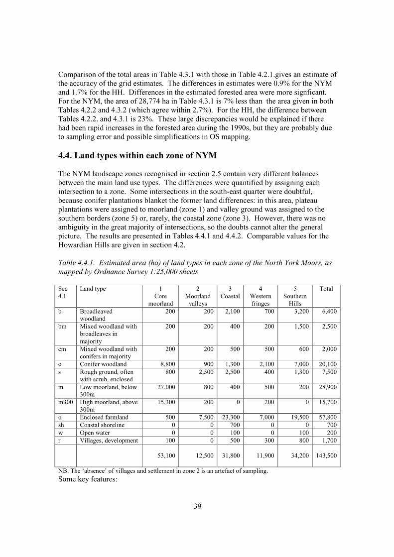
39
Comparison of the total areas in Table 4.3.1 with those in Table 4.2.1.gives an estimate of the accuracy of the grid estimates. The differences in estimates were 0.9% for the NYM and 1.7% for the HH. Differences in the estimated forested area were more signficant. For the NYM, the area of 28,774 ha in Table 4.3.1 is 7% less than the area given in both Tables 4.2.2 and 4.3.2 (which agree within 2.7%). For the HH, the difference between Tables 4.2.2. and 4.3.1 is 23%. These large discrepancies would be explained if there had been rapid increases in the forested area during the 1990s, but they are probably due to sampling error and possible simplifications in OS mapping. 4.4. Land types within each zone of NYM The NYM landscape zones recognised in section 2.5 contain very different balances between the main land use types. The differences were quantified by assigning each intersection to a zone. Some intersections in the south-east quarter were doubtful, because conifer plantations blanket the former land differences: in this area, plateau plantations were assigned to moorland (zone 1) and valley ground was assigned to the southern borders (zone 5) or, rarely, the coastal zone (zone 3). However, there was no ambiguity in the great majority of intersections, so the doubts cannot alter the general picture. The results are presented in Tables 4.4.1 and 4.4.2. Comparable values for the Howardian Hills are given in section 4.2. Table 4.4.1. Estimated area (ha) of land types in each zone of the North York Moors, as mapped by Ordnance Survey 1:25,000 sheets See 4.1
Land type
1 Core
moorland
2 Moorland
valleys
3 Coastal
4 Western fringes
5 Southern
Hills
Total
b Broadleaved woodland
200 200 2,100 700 3,200 6,400
bm Mixed woodland with broadleaves in majority
200 200 400 200 1,500 2,500
cm Mixed woodland with conifers in majority
200 200 500 500 600 2,000
c Conifer woodland 8,800 900 1,300 2,100 7,000 20,100 s Rough ground, often
with scrub, enclosed 800 2,500 2,500 400 1,300 7,500
m Low moorland, below 300m
27,000 800 400 500 200 28,900
m300 High moorland, above 300m
15,300 200 0 200 0 15,700
o Enclosed farmland 500 7,500 23,300 7,000 19,500 57,800 sh Coastal shoreline 0 0 700 0 0 700 w Open water 0 0 100 0 100 200 r Villages, development 100 0 500 300 800 1,700
53,100
12,500
31,800
11,900
34,200
143,500
NB. The ‘absence’ of villages and settlement in zone 2 is an artefact of sampling. Some key features:
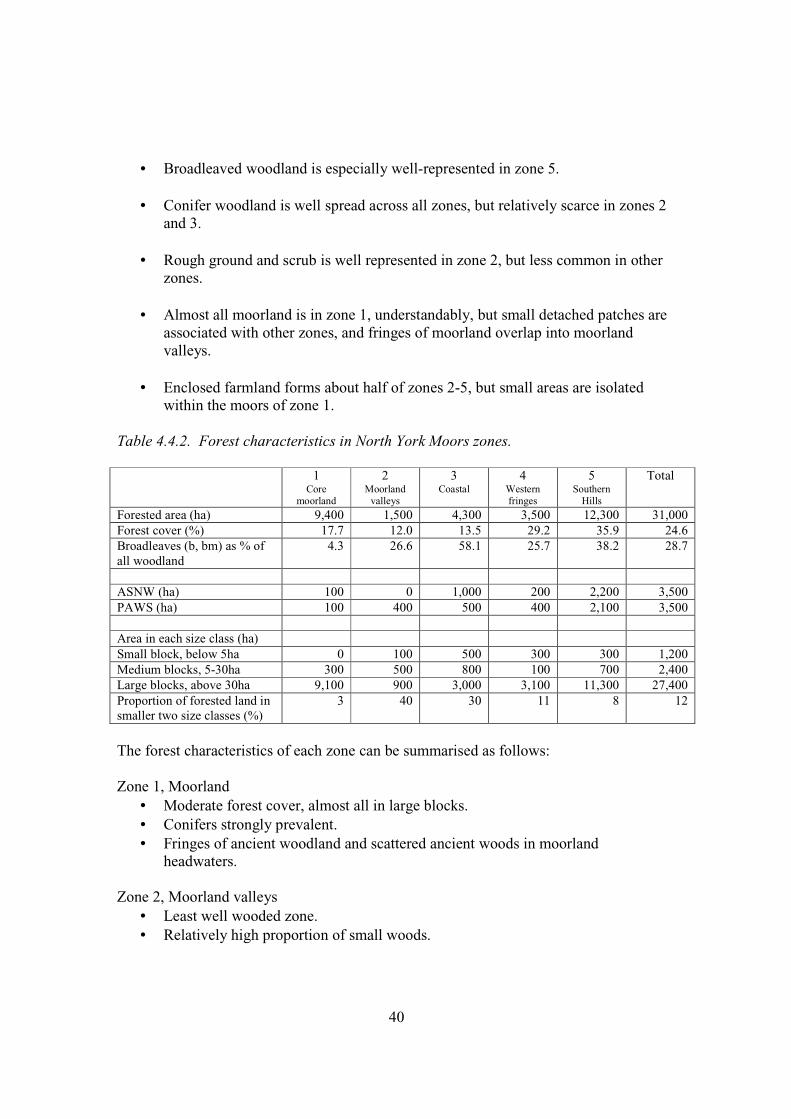
40
• Broadleaved woodland is especially well-represented in zone 5.
• Conifer woodland is well spread across all zones, but relatively scarce in zones 2
and 3.
• Rough ground and scrub is well represented in zone 2, but less common in other zones.
• Almost all moorland is in zone 1, understandably, but small detached patches are
associated with other zones, and fringes of moorland overlap into moorland valleys.
• Enclosed farmland forms about half of zones 2-5, but small areas are isolated
within the moors of zone 1. Table 4.4.2. Forest characteristics in North York Moors zones.
1 Core
moorland
2 Moorland
valleys
3 Coastal
4 Western fringes
5 Southern
Hills
Total
Forested area (ha) 9,400 1,500 4,300 3,500 12,300 31,000 Forest cover (%) 17.7 12.0 13.5 29.2 35.9 24.6 Broadleaves (b, bm) as % of all woodland
4.3 26.6 58.1 25.7 38.2 28.7
ASNW (ha) 100 0 1,000 200 2,200 3,500 PAWS (ha) 100 400 500 400 2,100 3,500 Area in each size class (ha) Small block, below 5ha 0 100 500 300 300 1,200 Medium blocks, 5-30ha 300 500 800 100 700 2,400 Large blocks, above 30ha 9,100 900 3,000 3,100 11,300 27,400 Proportion of forested land in smaller two size classes (%)
3 40 30 11 8 12
The forest characteristics of each zone can be summarised as follows: Zone 1, Moorland
• Moderate forest cover, almost all in large blocks. • Conifers strongly prevalent. • Fringes of ancient woodland and scattered ancient woods in moorland
headwaters. Zone 2, Moorland valleys
• Least well wooded zone. • Relatively high proportion of small woods.
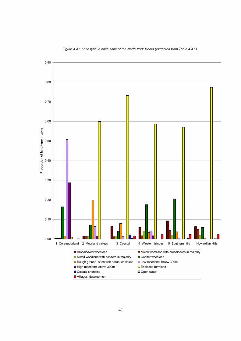
41
Figure 4.4.1 Land type in each zone of the North York Moors (extracted from Table 4.4.1)
0.00
0.10
0.20
0.30
0.40
0.50
0.60
0.70
0.80
0.90
1 Core moorland 2 Moorland valleys 3 Coastal 4 Western fringes 5 Southern hills Howardian Hills
Pro
po
rtio
n o
f la
nd
typ
e in
zo
ne
Broadleaved woodland Mixed woodland with broadleaves in majority
Mixed woodland with conifers in majority Conifer woodland
Rough ground, often with scrub, enclosed Low moorland, below 300m
High moorland, above 300m Enclosed farmland
Coastal shoreline Open water
Villages, development

42
This page is intentionally blank
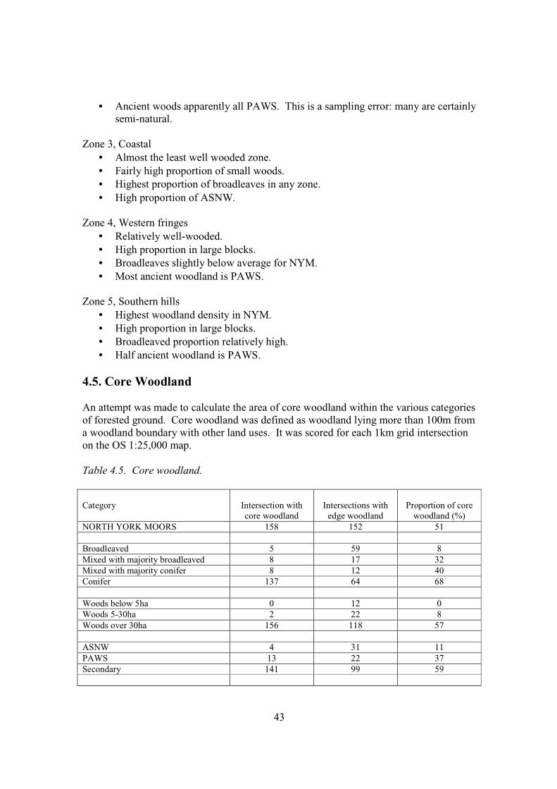
43
• Ancient woods apparently all PAWS. This is a sampling error: many are certainly semi-natural.
Zone 3, Coastal
• Almost the least well wooded zone. • Fairly high proportion of small woods. • Highest proportion of broadleaves in any zone. • High proportion of ASNW.
Zone 4, Western fringes
• Relatively well-wooded. • High proportion in large blocks. • Broadleaves slightly below average for NYM. • Most ancient woodland is PAWS.
Zone 5, Southern hills
• Highest woodland density in NYM. • High proportion in large blocks. • Broadleaved proportion relatively high. • Half ancient woodland is PAWS.
4.5. Core Woodland An attempt was made to calculate the area of core woodland within the various categories of forested ground. Core woodland was defined as woodland lying more than 100m from a woodland boundary with other land uses. It was scored for each 1km grid intersection on the OS 1:25,000 map. Table 4.5. Core woodland. Category
Intersection with core woodland
Intersections with
edge woodland
Proportion of core
woodland (%) NORTH YORK MOORS 158 152 51 Broadleaved 5 59 8 Mixed with majority broadleaved 8 17 32 Mixed with majority conifer 8 12 40 Conifer 137 64 68 Woods below 5ha 0 12 0 Woods 5-30ha 2 22 8 Woods over 30ha 156 118 57 ASNW 4 31 11 PAWS 13 22 37 Secondary 141 99 59
44
Category
Intersection with core woodland
Intersections with
edge woodland
Proportion of core
woodland (%) Moorland Zone 67 27 71 Moorland valleys 3 12 20 Coastal Zone 12 31 28 Western fringes 20 15 57 Southern hills 56 67 46 HOWARDIAN HILLS 12 27 32 Key features:
• The overall proportion for the whole NYMNP is 51% of all forested ground lies more than 100m from the edge of the wooded ground. This is probably a high proportion in national terms, though I know of no comparable data from other districts. Even the Howardian Hills value of 32% core woodland is probably high in national terms.
• Inevitably, the proportion is highest in the largest woods. Woods below 5ha have
no core woodland, and woods of 5-30ha have very little.
• The highest proportion of core woodland is associated with secondary and conifer woods, i.e., the large conifer plantations on open ground made mainly in the 20th century.
• Broadleaved woodland contains very little core woodland.
• Ancient, semi-natural woodland has very little core woodland. The great majority
of core woodland within ancient woods have been converted to conifer or mixed plantations.
• In zonal terms, forested ground on the moorland and western fringes has a high
proportion of core woodland, whereas the moorland valleys and coastal zones have a low proportion.
Although secondary conifer forests and PAWS are considered to be lower value for conservation than ancient woods and broadleaved woods, this analysis stresses that they do harbour a disproportionately large amount of core woodland habitat, which should be valuable for some species. 4.6. Semi-natural habitats in farmland The grid-based estimates of land type areas could not take into account semi-natural grassland within farmland, because this, like arable and leys, is shown without a symbol on OS maps. In an attempt to express these habitats on the same basis as other land
45
types, and to achieve an estimate of their spatial relationships, staff of NYM and HH scored all farmland intersections according to:
• whether they intersected with semi-natural grassland and mire. • the size of the semi-natural habitat. • the size of any woodland with which it had direct contact.
The total area for the NYM (Table 4.6.1) agrees reasonably well with the area given for semi-natural grassland in Table 4.3.1., especially as 300ha of the 4,900ha was mire, not grassland. Most semi-natural patches extend to more than 30ha, and all are contiguous with woodland, mostly large woods. Table 4.6.1. Semi-natural habitats (mostly grassland) within farmland in the North York Moors classified by (i) the area of the semi-natural habitat.
Size of contiguous woodland Area of semi-natural habitat None 0-5ha 5-30ha Above 30ha Total
0-5ha 0 400 200 200 800 5-30ha 0 300 200 600 1,100
Above 30ha 0 300 0 2,700 3,000 0 1,000 400 3,500 4,900
Summarising the position for the NYM:
• semi-natural grassland and mire in enclosed farmland extends to about 4,900ha, or 8.5% of the total area of farmland.
• patches are often extensive. Some 61% of all patches extend to more than 30ha.
• almost all patches are adjacent to forested land, and 71% of patches are adjacent
to forested tracts of more than 30ha. The position for the HH is somewhat different. Three grid intersections coincided with semi-natural habitats, indicating that the total area is about 300ha, or about 2% of the enclosed farmland. This can only be a very rough estimate, but it agrees reasonably well with the 397ha given in Table 4.3.1. The three intersections were a small (1-5ha) marsh that was isolated from woodland, and two 5-30ha patches of semi-natural grassland that were adjacent to woodland of 5-30ha and above 30ha respectively. Small though they are, this sample reinforces the impressions gained on the ground that semi-natural habitats form a very small proportion of the farmland of the HH, that they occur only in small patches, and that they are not well linked to woodland. They also appear to be less natural than those in the NYM, since the grassland appears to be mainly semi-improved.
46
4.7. Forestry Commission holdings The NYM Forest District estate totals 21,564ha (Source: FC, 13 September 2002) Of this, 19,156ha lies strictly within the NYMNP, and a further 319 ha in Dalby and Kilburn Forests lie adjacent to and contiguous with forest land within the NYMNP, i.e., a total of 19,475 ha. The FC therefore manage 13.5% of the NP. The current composition of the 19,475 ha in or adjacent to the NP is 73% conifer, 10% broadleaved and 17% open space, and the future composition envisaged is 59% conifer, 17% broadleaved and 24% open space. In the HH, FC hold 589 ha, or 2.9% of the AONB, of which conifers occupy 83%, broadleaves 7% and open ground 10%. Here, the future composition is planned to be 63% conifer, 24% broadleaved and 13% open. A recent survey has characterised these holdings in terms of the National Vegetation Classification and the native element within plantations (Goldberg 2000). Since most of the forest comprised recent secondary conifer plantations, this was inevitably a somewhat approximate exercise, but it served to identify the main inherent characteristics of the forest, and to estimate the degree to which native trees were represented. Table 4.7.1 gives the figures as they stood in September 2002, after some reassessments. The semi-natural fraction has been represented as an area by multiplying the area by the mean semi-natural proportion. Table 4.7.1. Forestry Commission holdings within the North York Moors NP in terms of the NVC and stock of native trees and shrubs. SN1
Predominantly semi-natural
SN2 Plantations with native element
in majority
SN3 Plantation with
substantial minority native
element
SN4 Plantation with minimal semi-natural element
TOTAL of
NVC TYPE
Semi-natural component
100-80% 80-50% 50-20% 20-0%
W6 1.1 0 0 0 1.1 W7 121.6 43.3 36.7 121.9 323.5 W8 171.9 32.9 82.0 511.9 798.7 W9 107.8 121.8 113.5 402.3 745.4 W10 167.0 87.1 128.5 2247.8 2630.4 W16 124.9 108.0 146.0 12668.7 13047.6 W17 11.3 0 1.2 50.5 63.0 NYM total 705.6 393.1 507.9 16003.1 17609.7 S/n fraction 0.9 0.65 0.35 0.1 S/n area equiv (ha)
635.0 255.5 177.8 1600.3 2668.6
47
Table 4.7.2. Forestry Commission holdings within the Howardian Hills AONB in terms of the NVC and stock of native trees and shrubs. SN1
Predominantly semi-natural
SN2 Plantations with native element
in majority
SN3 Plantation with
substantial minority native
element
SN4 Plantation with minimal semi-natural element
TOTAL of
NVC TYPE
Semi-natural component
100-80% 80-50% 50-20% 20-0%
W6 1.8 0.9 0 0.2 2.9 W7 2.1 1.7 0 3.4 7.2 W9 4.7 6.4 0.4 17.7 29.2 W10 23.8 6.4 10.3 152.5 193.0 W16 4.1 2.3 27.7 300.1 334.2 HH total 36.5 17.7 38.4 473.9 566.5 S/n fraction 0.9 0.65 0.35 0.1 S/n area equiv (ha)
32.9 11.5 13.4 47.4 105.2
Key points for NYM and HH combined :
• Most forested ground falls within the base-poor oakwood types W16 and W17. • The great majority of the forested ground is under plantations with little or no
semi-natural tree content, though it often has important semi-natural grassland or heath vegetation on ride sides or under thinned canopies.
• Only 1153 ha contains a majority of native species, and of this 36% (411 ex 1153) has passed through a phase of planting with conifers.
• Very little of the land falls within the very wet woodland type (W6). • On the relatively base-rich ground (W7-W9), a relatively high proportion (21%,
i.e., 408.1 ha ex 1904 ha) is semi-natural. • The semi-natural elements fall well below 20% of the total stock. The calculated
proportions are 15.1% for the NYM and 18.6% for the HH. • Some 76% (2106 ex 2774) of the estimated semi-natural cover is in SN classes 2-
4, i.e., has passed through a plantation phase, or is still part of a plantation. The ancient woodland within the FC NYM Forest District holdings was also assessed by Goldberg (2001) and has subsequently been updated to September 2002 (Tables 4.7.3 and 4.7.4). In the NYM, ancient woodland represented a small minority of the tree-covered ground, some 1706 ha in a total of 16,177 ha, or 10.5% of the total. In the HH, the proportion was higher: 112 ha in a total of 530.2 ha, or 21.1%. Of this, 434.2 ha of the two areas combined was classified as ASNW and 1383.8 ha was classified as PAWS. Thus, of the 742.1 ha of semi-natural woodland, 434.2 was ancient and 307.9 ha was recent secondary. And, of the 17434.1 ha of plantations (SN classes 2-4), only 1383.8 ha was on ancient sites.
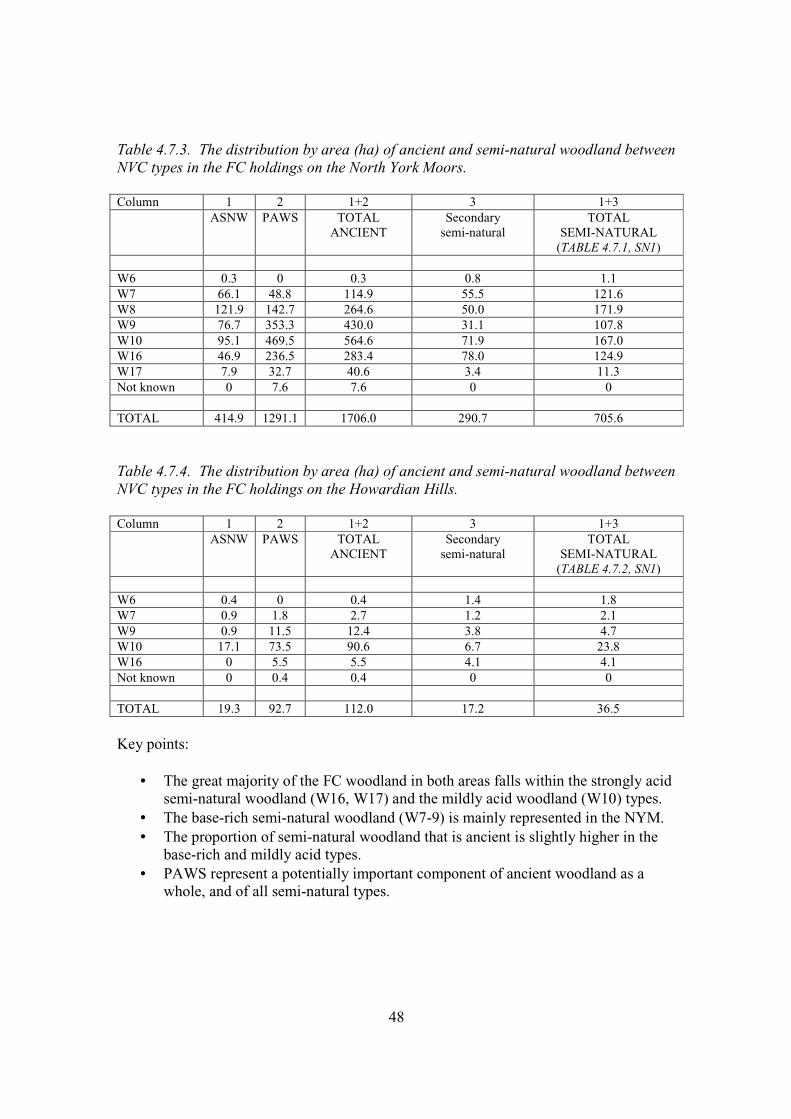
48
Table 4.7.3. The distribution by area (ha) of ancient and semi-natural woodland between NVC types in the FC holdings on the North York Moors. Column 1 2 1+2 3 1+3 ASNW PAWS TOTAL
ANCIENT Secondary
semi-natural TOTAL
SEMI-NATURAL (TABLE 4.7.1, SN1)
W6 0.3 0 0.3 0.8 1.1 W7 66.1 48.8 114.9 55.5 121.6 W8 121.9 142.7 264.6 50.0 171.9 W9 76.7 353.3 430.0 31.1 107.8 W10 95.1 469.5 564.6 71.9 167.0 W16 46.9 236.5 283.4 78.0 124.9 W17 7.9 32.7 40.6 3.4 11.3 Not known 0 7.6 7.6 0 0 TOTAL 414.9 1291.1 1706.0 290.7 705.6
Table 4.7.4. The distribution by area (ha) of ancient and semi-natural woodland between NVC types in the FC holdings on the Howardian Hills. Column 1 2 1+2 3 1+3 ASNW PAWS TOTAL
ANCIENT Secondary
semi-natural TOTAL
SEMI-NATURAL (TABLE 4.7.2, SN1)
W6 0.4 0 0.4 1.4 1.8 W7 0.9 1.8 2.7 1.2 2.1 W9 0.9 11.5 12.4 3.8 4.7 W10 17.1 73.5 90.6 6.7 23.8 W16 0 5.5 5.5 4.1 4.1 Not known 0 0.4 0.4 0 0 TOTAL 19.3 92.7 112.0 17.2 36.5
Key points:
• The great majority of the FC woodland in both areas falls within the strongly acid semi-natural woodland (W16, W17) and the mildly acid woodland (W10) types.
• The base-rich semi-natural woodland (W7-9) is mainly represented in the NYM. • The proportion of semi-natural woodland that is ancient is slightly higher in the
base-rich and mildly acid types. • PAWS represent a potentially important component of ancient woodland as a
whole, and of all semi-natural types.