Embed Size (px)
Citation preview

NATIVE MINES LIMITED SUMMARY REPORT ZYMOETZ PROPERTY Oct. 1, 1967 /oSJ^ =
Dolmage, Campbell & Assoc. Ltd.
i
DOLMAGE, CAMPBELL & ASSOCIATES CONSULTING GEOLOGISTS
80S BANK OF CANADA BUILDING VANCOUVER I, B.C.
Native Mines Ltd
Summary Report
ZYMOETZ PROPERTY
Terrace, B.C.
Oct. 1 , 1967.
Douglas D. Campbell Dolmage-Campbell & Assoc. Ltd. Vancouver, Canada,
TABLE OF CONTENTS
Page
CERTIFICATE
INTRODUCTION 1
SUMMARY & RECOMMENDATIONS 3
GEOLOGY 5
Regional Setting 5
Property geology 6
ORE OCCURRENCES 8
DRILL & TRENCH RESULTS 9
CONCLUSIONS 11
ILLUSTRATIONS following page
Figure 1 - Location map 4
Figure 2 - Location of showings, 1" = 10001 7
Figure 3 - Lower Showing 1" = 100' 10
Figure 4 - Lower Showing, sections 10
Figure 5 - Upper Showing, 1" = 100' 10
Figure 6 - " " , sections 10

D O L M A G E , C A M P B E L L & A S S O C I A T E S CONSULTING GEOLOGISTS
SOS BANK OF CANADA BUILDING
V A N C O U V E R I, B . C .
October I , 1967
CERTIFICATE
I , Douglas D . Campbel l , wi th business and residential addresses in Vancouver, British Columbia, do hereby cert i fy that :
1 . I am a consulting geological engineer.
2 0 I am a graduate of the University of British Columbia, (B .A.Scc , Geological Engineering, 1946), and of the Cal i fornia Institute of Technology, ( P h . D . , Economic Geology and Geophysics, 1955).
3 . I am a registered Professional Engineer of the Province of British Columbia.
4 . From 1946 unt i l 1957 I was engaged in mining and mining exploration in Canada and the United States as geologist for a number of companies. I was chief geologist for Eldorado Min ing and Refining C o . L td . when I retired in 1957 to begin private practice as a consulting geologist.
5 . I personally have examined the Zymoetz River Property of Nat ive Explorations L td . in 1965 and 1966 and have assessed a l l avai lable data, government reports and private letters, plans and reports concerning this property.
6 . I have not received, nor do I expect to receive, any interest direct ly or indirect ly in the properties or securities of Nat ive Explorations L td , or of any associated companies.
Respectfully submitted,
U^A Douglas D . Campbel l , P.Eng. , Ph .D .
VANCOUVER, C A N A D A .
D O L M A G E , C A M P B E L L & A S S O C I A T E S C O N S U L T I N G G E O L O G I S T S
8 0 S BANK OF CANADA BUILDING
VANCOUVER I ,B.C.
- 1 "
INTRODUCTION
The writer first examined the Zymoetz Property for several days in October , 1965, when the property had just been staked and explored by a number of trenches. The property was again visited by the writer in August, 1966, after six diamond dr i l l holes, extensive geological mapping and a geochemical soils survey had been completed. At that time the wri ter logged the core and checked the geological mapping of the principal showings 0 During the summer of 1967 more diamond d r i l l i n g , soil sampling and surface trenching was done on the property by members of Associated Geological Services L td . A l l of the information thus accumulated on the property has been made a v a i l able to the writer for the compilation of this report 0
Location; (54° 29' N , 128° 08' W)
The property is located in west-central British Columbia, 21 miles east of the town of Terrace, up the Zymoetz River. From Terrace it is reached by 30 miles of highway and excellent logging road, a branch of which climbs up the mountain at the property to the main showings. The town of Terrace can be reached by the northern Trans Provincial Highway, or by Canadian Nat ional Railway from Prince George and by dai ly C . P . A i r l ine fl ights from Vancouver. The main showings on the property are at elevations between 1600 and 2000 feet , approximately 600 feet above the floor of the Zymoetz River. The area is one of densely forested, glaciated mountains but the slopes at and below the main showings have been largely denuded or thinned of forest by logging and f i r e .
History; This property is a new discovery, having been discovered and staked in 1962. Nat ive Explorations L td . optioned the property in 1965 and during the summer of that year crews of that company trenched and sampled the best exposures and made a reconnaissance geological map of the area surrounding the showings.
In 1966 Nat ive Explorations L td . extended the mapping and soil sampling of the property and dr i l led 13 Ax diamond dr i l l holes on the Lower

- 2 -
Showings for a total of 2947 fee t . In add i t ion , one mile of new tote road was bui l t and 50 new claims were staked and added to the property.
In 1967 seven more diamond dr i l l holes (BQ), to ta l l ing 2493 fee t , were dr i l led to explore the Upper Showhgs. In addit ion a number of new surface trenches were excavated to extend the principal showings.
Property: The Zymoetz Property is comprised of one group of 71 mineral c laims, nine of which are owned by Doreen Mineral Developments and the remainder by Nat ive Explorations L td . The Doreen claims are under option to Nat ive Explorations L td .
The claims comprising the property are:
Zymoetz 1-9 Zymoetz Fractions 1-6 Zymoetz 10-15 Kelly 1-10,12-20,24-32
9 6 6
28 Native 1-8 8 Saint 1-9, 11, 35-38 U
Total 71
The claim block is approximately square in outl ine and is oriented north-south with the northern boundary along the south shore of the Zymoetz River. The western boundary is at about M i le 19, Mattson Creek, on the road from Terrace and the eastern boundary is at M i l e 23 , Kel ly Creek. The property extends for a distance of 15,000 feet to the south, to the crest of the mountain.
Complete claim maps are available at Nat ive Explorations L td .

D O L M A G E , C A M P B E L L & A S S O C I A T E S C O N S U L T I N G G E O L O G I S T S
8 0 S BANK OF CANADA BUILDING
VANCOUVER I, B.C.
- 3 -
SUMMARY & RECOMMENDATIONS
The Zymoetz Property of Nat ive Explorations L t d . , consisting of 71 claims, is located on an excellent logging road 21 miles east of Terrace, B . C . , on a rugged, heavi ly wooded mountain forming the south side of the Zymoetz River v a l l e y .
The area is pr incipal ly underlain by volcanic f low and pyroclastic formations of the Hazelton Group of Jurassic age, near the eastern contact of the Coast Range Bathol i th. On the lower elevations of the Zymoetz Property the volcanic rocks are intruded by an irregularly shaped s i l l - l i ke body of f e l d spar porphyry and by a younger stock of granodior i te.
The economic mineralization on the property occurs as f inely disseminated bornite and chalcopyr i te, pr incipal ly w i th in the pyroclastic or tuffaceous volcanic rocks wi th in 1000 feet of a major topographic lineament that trends southeastward across the property. Wi th in the ore zones some copper mineral izat ion occurs for a few tens of feet into the feldspar porphyry and a very negl ig ible amount wi th in the granodior i te.
Six zones of copper mineralization are exposed over a length of 8000 feet of the lineament and of these only two , the Lower and the Upper showings, have been explored by trenching and dr i l l ing, . The potential of the property for f ru i t fu l exploration along the lineament is exce l lent .
Exploration of the Lower Showing by nine dr i l l holes and numerous trenches revealed an extensive tonnage of sub-marginal grade o re .
Exploration of the Upper Showing by thirteen dr i l l holes has indicated a body of open pit ore of:
1,300,000 tons @ 1.00% Cu and 0.75 o z / t . Ag
This orebody is open at both ends and at depth, further dr i l l ing is necessary to fu l ly del imit the reserve. The recoverable value of this ore at present metal prices is about $10 . per t o n , which is considered to be profitable provided more reserves of this orebody and other similar orebodies can be indicated by d r i l l i ng , the only practical form of exploration on this property.
- 4 -
RECQMMENDATIONS:
To determine the immediate economic potential of the Zymoetz Property the wri ter recommends the fo l lowing dr i l l program, specif ical ly designed to determine the complete tonnage of the Upper Showing Orebody and to explore other promising showings for similar orebodies:
Upper Showing Orebody - 2 1 holes - 6300 f t .
Other Exploration - 24 holes - 5400 f t .
Total - 11700 f t .
This program is we l l warranted by the results to date and w i l l permit a f irm assessment of the potential of the property.
The total cost of such a program is estimated to be $152,000.00.
Respectfully submitted,
Douglas D . Campbel l , P.Eng. , Ph .D .
Vancouver, Canada.

J ^ w ^ /
P>V-
. < < / :
A / ^
\ V > J hr«
\ T A T .
\ l -
7-->
'>r'/;y > ' > - > »/ v / J / ' M , \ \
» \ ' / I ^ v v V,V
^ , M V / J ' / I V 1 V j
V I >• : - ; ' ' Vl»'/N| v\r\ ^\ \- »'> . O l / v ^ N
^GRANODIORITE \/
■ \ / > r ^ x < / ^ i
. / \ > 0 / / > :»- o> i ^
/ / XiV sl^ni '■or L\ x
v N V -
/ \
:o TERRACE / / x
,W ' / - / / . \ V . N \
' M > 0 >
i - / ' t\,
K V v w / \ '
to\/ / W 1 \r ?'>'•!!/,\
^ < :
' \ - J
/ - t \ ~ ' S N > r,r^: ' / > / ^ / ,
l / v ' ' ' , / / i ,
\ ' ' » N :
> *>^ ■I'I \n
»-^\ \ I , /\ ' I V / \ r*7/ \v
Ml O \ | / > I \ / V I I '
■tfr o'^x:
i'vUV.il ^/J-^v'V,
/ M -vV/
/ ^ _ i ' v ' v \, Airport
\ /_ 0~/J.V ' / . V
V > 1 l " l ' '/£./ \vT' V^'.V
/ / A \ | /
v / \ x^ >\» 1 / / ^ / < ; >
x:/\ x# / ' / v \W. - > l O y
K /
j e *
i M j ' x U l / , ICT ' \ M / 'x *
V x l \ / / x / i - 1 ' / A / i« i> i l i V
v,\ ..^-x J-S ^ > > '
PR. RUPER3 ^
.<<C' i , ,/^.v C
A/ . \ / 1 / ^ , 1 V
i\y\VUV | V \ »,
. ' > / / ' !> .vib- >\v-\
•^liV* M7<
:V
zrttOErz
sZYMOETZ PROPERTY
I- / ^ \ ^ \ / t
N | N \ » V .\/'
UPPER HAZELTON VOLCANICS
CONSULTANTS
EXPLORATIONS LTD. VANCOUVER, CANADA
ZYMOETZ PROPERTY
GENERAL GEOLOGY SCALE: 4 miles AUG. 1967 FIG. |
- 5 -
GEOLOGY
REGIONAL SETTING:
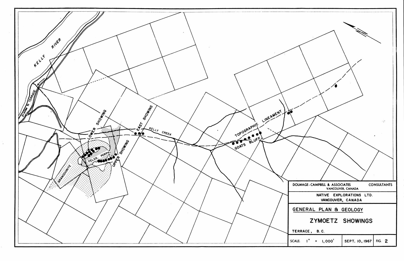
Terrace, B .C. is located in a broad intermontane basin formed by the crossing of the present Skeena Val ley and what was probably a major preglacial river val ley now part ial ly occupied by the Kit imat River. West and south of Terrace the Coast Range Mountains rise to 6500 feet , and east of Terrace the Bulkley Ranges rise to 8000 fee t . The elevation of the Terrace Basin is about 500 fee t . The Zymoetz River flows westward from the Bulkley Ranges to join the Skeena River at the northeast corner of the basin. The Zymoetz Property is located in the Bulkley Mountains on the south side of the Zymoetz River 21 miles east of Terrace. The principal showings, comprised of copper mineralization in a sequence of volcanic rocks, are scattered over a distance of about one mile along the north f lank of the mountain that forms the south wa l l of the Zymoetz val ley just west of the Clore River.,
The Terrace basin is located on the eastern edge of the Coast Range batholith of granodiorit ic intrusive rocks. The region west and south of Terrace is underlain predominantly by granodiorite intrusive rocks. The area north and east of Terrace is underlain by Mesozoic formations that have been extensively intruded by apophyses of granodiorite related to the batholith to the west.
The western fringe of the intruded rocks, wi th in 16 miles east of Terrace, is comprised predominantly of Triassic sedimentary rocks including limestones,
sandstones and cherts. East of these rocks the underlying formations are volcanic and sedimentary rocks of the Hazelton Group of Jurassic age . The western border of this group lies approximately two miles west and north of the Zymoetz Group property.
The Zymoetz Property is underlain by Hazelton Group volcanic rocks local ly intruded by stocks of granodiorite which crop out on the lower elevations of the mountain sides0 The Hazelton rocks are comprised of intercalated andesitic and basaltic flows and pyroclastics. The thicknesses of the volcanic beds, as we l l as their a t t i tude, are not evident in the l imited exposures on the Zymoetz Property but in the region the beds generally range up to 100 feet in thickness and strike north-north east and dip 35-60 degrees eastward. Regional faults or shear zones wi th minor displacements have been mapped in the area but as yet none have been noted on the Zymoetz Property.
- 6 -
Outcrops are generally restricted to scattered bluffs along the mountainsides,,
PROPERTY GEOLOGY
The Zymoetz claims are largely blanketed by forest covered glacial outwash and thin t i l l deposits but bedrock crops out commonly as cl i f fs and subdued bluffs„ In addit ion a large number of shallow trenches and pits have been excavated in the area of the main showings by crews of Nat ive Explorations L td .
The portion of the Zymoetz Property that has been geological ly mapped is confined to the eastern side of the claim block from the Zymoetz River southeastward up the val ley of Kel ly Creek for a distance of about 15,000 feet , in a strip about 3000 feet in width spanning a vert ical interval of about 4000 fee t . The upper elevations of this strip are covered by the Nat ive Claims and the lower elevations by the Zymoetz Cla ims. The copper occurrences that have been trenched and dr i l led are a l l located on the Zymoetz Claims.
A l l of the mapped area is pr incipal ly underlain by a sequence of volcanic rocks that show few structural features in outcrop exposures and which are largely andesitic in composition, w i th minor basalts, and which range in texture from aphanitic to porphyritic to f ragmental . The predominant rock types of this sequence are purple and maroon-hued rocks that include massive tuf fs, agglomerates and aphanitic f lows. These rocks are generally massive, hard, competent, aphanitic to medium grained and dense. Locally they contain feldspar phenocrysts, amygdules and fragments (agglomeratic).
Intrusive into this volcanic sequence are two other rock types, both of which are exposed only on the Zymoetz Claims lower down the mountain s ide. The oldest of these intrusives is a s i l l - l i ke body of feldspar porphyry which crops out on Zymoetz N o . 2 M . C . as a west-trending band 1600 feet in length and 200-300 feet in width and which disappears under overburden at Kel ly Creek to the east and is terminated to the west by intrusive granodiorite (F ig . 2 ) . The feldspar porphyry is a massive, dense, dark green to pink-grey and whi te rock comprised of a green-grey andesitic matrix w i th in which are ho lo -crystal l ine white plagioclase phenocrysts up to 2 inches in length which comprise up to 50% of the rock . The phenocrysts in this rock are commonly grouped in star clusters and rarely show any preferred f low or ientat ion. A similar porphyry body, mapped by the writer on the north side of the Zymoetz River, several
- 7 -
miles to the east, proved to be intrusive into the volcanic sequence as a crosscutting s i l l - l i ke sheet. It is only sparsely mineralized by copper on both properties but it is def ini te ly pre-copper mineralization in age .
The youngest intrusive exposed on the Zymoetz Claims is an i r regular-shaped stock of medium crystall ine granodior i te. This rock is composed pr incipal ly of feldspar and hornblende and is a uniform grey and black to pink and black typ ica l Coast Range-type of granodior i te.
The granodiorite crops out as an elongate stock, about 1000 feet in north-south w i d t h , that is open to the west and that fingers out to the east near Kel ly Creek. It is evidently an outl ier of a larger intrusive mass that underlies much of the r iver - leve l outcrops further west.
The intruded volcanic rocks are intensely granit ized wi th in tens of feet of the granodiorite and are variously feldspathized with pink potash f e l d spar for distances up to 100 feet from the contact . This feldspathization is first evidenced as patches and vein lets and then becomes so pervasive as to convert the recrystall ized rock to a pseudosyenite. The granodiorite and the granit ized rocks are very sparsely mineralized wi th chalcopyrite and rarely bornite; however, the feldspathized "metavoIconics" are locally r ichly mineralized wi th borni te, chalcocite and, less commonly, chalcopyr i te .
Structure: The only known large structure exposed on the property is a pronounced topographic lineament that trends up Kel ly Creek southeastward from the Zymoetz to the Nat ive claims for a distance of about 3 mi les. A l l of the known copper occurrences on the property are located wi th in 1000 feet of this l ineament. The lineament is characterized by vert ical rock bluffs along its trend but no significant dislocation of the geology is discernible on either side of i t , nor are there any exposures of sheared or slickensided rocks along i t , although admittedly exposures are sparse. Within the strike length of this lineament elevations rise irregularly from 1,200 feet to 5,000 feet and since the lineament is essentially straight throughout this interval it therefore must be ver t ica l or near -ver t i ca l .
S igni f icant ly , the rocks on both sides of the lineament, and in its immediate v i c i n i t y , are generally closely fractured and jointed by fractures that trend north-northeastward, at right angles to the lineament, and dip 30° -60° to the northwest.

- 8 -
ORE OCCURRENCES
The mineralization of economic interest on the Zymoetz Property is copper I It occurs as fine grained borni te, chalcocite and chalcopyrite disseminated along fracture planes and throughout the groundmass of the host rock . The most favourable host rocks in order of importance are: pyroclastic volcanics, feldspathized volcanics and andesitic f low rocks. A l l other rocks are hosts to the copper mineral ization but in relat ively meagre and insignificant amounts. The copper minerals are so f inely dispersed that they are inconspicuous and are generally detected by malachite staining on surface exposures. Assays of core indicate about 3 /4 oz/ ton of silver per percent of copper in the ore mater ia l . The chalcopyrite appears to be confined to the granodiorite and the granitized rocks.
The distribution of the copper mineralization as is known thus far is concentrated in the v ic in i ty of the major topographic lineament previously described as trending up Kel ly Creek, F i g . 2 . Significant copper minera l i zation has been exposed at six locations along a 11,000 f t . strike length and 4000 f t , ver t ica l interval of this l ineament. Two of these showings are on the Zymoetz Claims and four are at the upper elevations of the Nat ive Claims. A l l of the dr i l l i ng and trenching done to date have been concentrated on the Lower and Upper Showings on the Zymoetz N o . 2 M . C . , representing a very small portion of the staked length of the lineament but chosen because it is the most readily accessible por t ion.
The decision was made in 1966 to explore the Lower and Upper Showings wi th a reconnaissance program of diamond dr i l l holes designed p r i marily to determine the grade, the extent and the structural controls, i f any, of the copper mineralization in that local area of theregional l ineament, This program was completed in 1967 and the results have revealed that the mineralization occurs both as fracture f i l l ings and as disseminations wi th in the volcanic rocks. There appears to be some spatial relation of the copper mineral ization to the v ic in i t y of the porphyry intrusive and also the granodiorite intrusive, but these relationships are not we l l established, merely inferred. The mineralization does not appear to be control led by any particular faul t or fracture sets / at least none are exposed in the trenches or the dr i l l cores; i t does seem to be concentrated on the regional l ineament.
Although the dr i l l ing to date has been entirely of a geological ly exploration nature i t is possible to summarize the results in the terms of tonnage and grade. This is done in the fol lowing section of this report .
- 9 -
DRILL A N D TRENCH RESULTS
Nine diamond dr i l l holes have been dr i l led to investigate the Lower Showing, (F ig . 3 ) , and thirteen holes to explore the Upper Showings. The results from the Lower Showing are disappointing and somewhat inconclusive; the results from the Upper Showings have been considerably encouraging and def in i te ly warrant further investigation of that particular a rea. A discussion of the results from each of these showings fol lows:
LOWER S H O W I N G :
As shown in Figure 3 , the Lower Showings represent a deposit that is geological ly confined on three sides, but open at depth . The south and west sides of the minera lized band of volcanics are cut off by underlying intrusive granodiorite and the south side by intrusive porphyry (see sections on F i g . 4 ) . The surface trenches revealed disseminated bornite mineralization in the moderately intensely fractured volcanics but none in the granodiorite and negligible amounts in the porphyry above. As shown in Figure 3 , the surface trenches exposed a considerable length (600 f t . ) and width (100 f t . ) of consistent mineral izat ion but relat ively low grade, averaging about 0 .30% C u .
O f the nine holes dr i l led on the Lower Showing three of the earliest were more or less entirely w i th in granodiorite or porphyry, (F ig . 4 ) , which returned no information on the ore zone wi th in the volcanics but which did establish the fact that the intrusive rocks are generally barren. Generally in the Lower Showing the d r i l l i ng , although not we l l sited geologica l ly , (F ig . 4 ) , did not intersect ore grade mater ia l . Local good intersections were obtained, (DH 2 and 6 ) , and a very widespread pattern of low grade minera l i zation was revealed, but the dr i l l holes are few and irregularly spaced, thus leaving much of the favourable volcanic band unexplored.
From the results to date no ore reserves are wel l established in the Lower Showing; however, the large extent of low grade copper mineralization is of interest and the favourable band of mineralization is open at depth and to the southeast.
UPPER S H O W I N G :
The Upper Showing of the Zymoetz Property, (F ig . 5 ) , lies along the steeply south-dipping hanging wal l contact of the porphyry intrusive body. Dr i l l ing and surface trenching have indicated that this zone of copper mineralization wi th in the volcanics is apparently spatially related to the contact , but locally it penetrates the porphyry for a few tens of fee t . Its fu l l w i d t h , length and depth

- 10 -
have not been defined by the dr i l l ing but to date a possible orebody has been outl ined that is 600 feet in length, about 120 feet in true width and about 250 feet in depth . Since the contact of the porphyry is most irregular care must be taken in the fo l lowing of the trend of the orebody wi th dr i l l holes.
Indicated Ore : It is inadvisable to calculate an "ore reserve" for the Upper Showing at this time on the basis of so few holes and wi th the zone st i l l open and not def ined. However, the core recovery was excellent and the results from hole to hole have been consistent, so it is reasonable to make a preliminary estimate of the ore indicated to date . Using the data i l lustrated in Figure 6 such an estimate, using a tonnage factor of 11 .5 c u . ft . / t o n , is:
INDICATED ORE - 600 (120) 250 = 1,600,000 tons @ 0 .84% Cu 11.5
The above grade is not an exact calculat ion because only six s ig ni f icant holes are available and they are irregularly spaced and in different geological environments; however, the figure is probably wi th in a reasonable degree of accuracy.
If DH 18 is discarded the indicated ore then becomes:
1,300,000 tons @ 1.00% Cu and 0.75 o z . A g / t .
The geological probabil i ty of expanding this reserve at depth and lateral ly is good; the extent to which this can be done is con jectura l .
At $0.48 (Can) / lb . for copper and $1.60 (Can . ) / oz . for s i lver, and 90% recovery for both, the recoverable value of this material is $9.72 per t o n . Most of it is minable by open p i t , and the simple mineralogy indicates low cost m i l l i ng ; therefore there is probably a reasonable profit to be made on such o re . What is required is enough reserves to justify a mi l l of sufficient size to generate a worthwhile cash f l o w . To this end an extended dr i l l program is required for the Upper Showing as we l l as for a l l of the other showings along the lineament to the southeast, (F ig. 2 ) , for a length of 8000 fee t .


![GRANDWELL HOLDINGS [PRIVATE] LIMITED MINISTER OF MINES](https://img.pdfslide.net/doc/110x75/6299c9599fa1042c0d138e24/grandwell-holdings-private-limited-minister-of-mines-.jpg)