Embed Size (px)
Citation preview
210 Tokatoka PNAP reconnaissance survey report
Significance
This site derives its significance from its size, located within a very modified
Ecological District. Native shrublands provide potential habitat for threatened
species including orchids, NI brown kiwi and lizards.
A Queen Elizabeth II National Trust Open Space covenant protects 4.9 ha of
this site.
Additional survey is required to determine the full ecological significance of
this site. Approximately 125.5 ha of this site occurs within an ‘At Risk’ land
environment (A6.1b) and 6.4 ha within a ‘Critically Underprotected’ land
environment (A6.1c) (Walker et al. 2007).
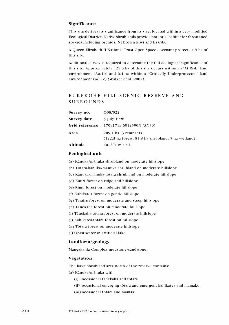
P U K E K O H E H I L L S C E N I C R E S E R V E A N D S U R R O U N D S
Survey no. Q08/022
Survey date 3 July 1998
grid reference 1709171E 6012590N (Ay30)
area 209.1 ha, 3 remnants
(122.3 ha forest, 81.8 ha shrubland, 5 ha wetland)
altitude 40–201 m a.s.l.
ecological unit
(a) Känuka/mänuka shrubland on moderate hillslope
(b) Tötara-känuka/mänuka shrubland on moderate hillslope
(c) Känuka/mänuka-tötara shrubland on moderate hillslope
(d) Kauri forest on ridge and hillslope
(e) Rimu forest on moderate hillslope
(f) Kahikatea forest on gentle hillslope
(g) Taraire forest on moderate and steep hillslope
(h) Tänekaha forest on moderate hillslope
(i) Tänekaha-tötara forest on moderate hillslope
(j) Kahikatea-tötara forest on hillslope
(k) Tötara forest on moderate hillslope
(l) Open water in artificial lake
Landform/geology
Mangakahia Complex mudstone/sandstone.
Vegetation
The large shrubland area north of the reserve contains:
(a) Känuka/mänuka with
(i) occasional tänekaha and tötara.
(ii) occasional emerging tötara and emergent kahikatea and mamaku.
(iii) occasional tötara and mamaku.
211Tokatoka PNAP reconnaissance survey report
212 Tokatoka PNAP reconnaissance survey report
(b) Abundant tötara with common känuka/mänuka and occasional tänekaha,
töwai, pūriri, rimu and rewarewa.
(i) Also occurs with isolated mamaku and tī köuka.
(c) Känuka/mänuka and tötara which occur with occasional tī köuka, mamaku
and the odd tänekaha.
(i) Also occurs in patches with mamaku in low abundance.
(ii) Is common in the shrubland area directly north of the reserve, with
occasional mamaku, tänekaha, rewarewa and rimu.
The forested areas of the site are dominated by taraire.
The following vegetation types were identified:
(d) In the northern end of the reserve, abundant kauri occurs on some ridges,
along with pūriri and rimu.
(e) Areas of rimu forest also occur here, along with rare emergent kauri,
pūriri, rewarewa and tötara. There is a notable patch of old-growth rimu in
this area.
(f) Kahikatea, which is common in a small area here along with frequent
nīkau and occasional tötara, karaka, pūriri, tītoki and tī köuka.
(g) Taraire forest occurs in the north with frequent emergent rewarewa.
Emergent rimu and kauri (including very large kauri), kahikatea and nīkau
are also present.
(h) In the northwestern corner of the reserve, a small area of abundant
tänekaha occurs with the odd rewarewa, emergent kahikatea, tötara and
känuka/mänuka.
(i) Adjacent to the shrubland area, tänekaha and tötara are common. Pūriri,
rimu, töwai, pukatea, mamaku, nīkau, tī köuka and känuka/mänuka are
present.
Taraire forest, type (g), is abundant on the southeastern hill face of the
reserve along with frequent rewarewa and occasional emergent rimu, and
kauri (ridges), tänekaha, puka, pūriri, kahikatea and mamaku.
In areas on the toeslopes of this face, abundant kahikatea, type (f), occurs
with small amounts of pukatea, rimu, nīkau, tī köuka and mamaku.
(j) Emergent kahikatea with tötara also occurs on the toeslopes of this face
with occasional rewarewa, nīkau, rimu and mamaku.
Taraire forest, type (g), is dominant on the southern face and western side
of the reserve along with frequent rewarewa (20%) and occasional pūriri,
mamaku, nīkau, epiphytic puka, emergent rimu, pukatea and kahikatea.
Emergent kahikatea associated with tötara, type (j), occurs on the toeslopes
of the southern face. Other species present include kauri, pukatea, tī köuka
and nīkau.
(k) Abundant tötara occurs in the north of the western side of the reserve
along with occasional emergent rewarewa, kahikatea, nīkau, pūriri and
känuka/mänuka (edges).
A pocket of emergent kauri forest, type (d), is located on the northwestern
corner of the reserve along with frequent emergent rimu and occasional
tänekaha.
The two small forested remnants northwest of the reserve are associated
with an artificial lake (type n).
213Tokatoka PNAP reconnaissance survey report
The northern remnant of the two comprises type (g) abundant taraire, with
occasional rimu, kahikatea, rewarewa, kohekohe, mamaku, pukatea and
nīkau.
Abundant tötara, type (l), also occurs here with frequent kahikatea and
occasional rewarewa.
Kahikatea and tötara forest, type (j), occurs in the remaining remnant with
frequent emergent kauri and emergent rimu, tänekaha and känuka/mänuka
in low abundance.
(l) Open water in two artificial lakes occur in the north.
Significant flora
2006 records of kaikömako, kohia and kotukutuku (all regionally significant
species) (SSBI Q08/H004).
fauna
records from SSbi Q08/H004: 1992 record of NI brown kiwi (Nationally
Vulnerable). 2006 record of kūkupa (regionally significant species) and kauri
snail (Gradual Decline), NZ kingfisher, grey warbler, tūī, NI fantail, and
silvereye. 1995 record of Australasian harrier and shining cuckoo.
Auckland green gecko (Declining) reported in shrubland by landowner
adjacent to the Scenic Reserve.
Historical records (1977) in SSbi Q08/H005 and SSbi Q08/H006 of
wetland birds associated with the two artificial lakes in the north: grey duck
(breeding) (Nationally Critical), NZ dabchick (Nationally Vulnerable), black
shag (Naturally Uncommon), little shag (Naturally Uncommon) (breeding—
12 nests recorded), paradise shelduck (200 recorded), pūkeko, black swan
(breeding), NZ kingfisher and welcome swallow.
Significance
The Pukekohe Hill Scenic Reserve contains some areas of unmodified
kauri-podocarp/broadleaf forest on the upper slopes with large old growth
specimens of kauri, kahikatea, mataī, tötara, rewarewa and pūriri. The
reserve supports Threatened, At Risk and Regionally significant species and
is complemented by a sizeable area of shrubland in the north. Shrubland
areas can provide important habitat for threatened species including orchids,
NI brown kiwi and lizards.
The two artificial lakes in the north provide habitat for waterfowl and there
are historical records of threatened species.
Representative site for several shrubland types, type (a), (b), (c) and (d).
Representative site for type (d) kauri forest, type (e) rimu forest, type (g)
taraire forest and type (k) tötara forest.
The scenic reserve area is listed as a soil site of regional importance for:
Containing soil-forest associations that are largely undisturbed•
Containing good examples of an uncommon soil type—White-Cone soils.•
(Arand et al. 1993)
Approximately 99.9 ha of the Pukekohe Hill Scenic Reserve, administered by
DOC, is contained within this site. In addition, 11.2 ha is protected by Queen
Elizabeth II National Trust Open Space covenant.
214 Tokatoka PNAP reconnaissance survey report
This is one of only two relatively large protected areas in the Tokatoka
Ecological District. The other area is the Manganui River Wildlife Management
Reserve (194.5 ha), which is contained in PNA site P07/086. The rest of the
reserves within the District are under 50 ha in area.
Approximately 1 ha of this site occurs within a ‘Chronically Threatened’ land
environment (A6.1d and G3.1b), 62.3 ha within an ‘At Risk’ land environment
(A6.1b), 48.5 ha within a ‘Critically Underprotected’ land environment
(A6.1a and A6.1c) and 92.7 ha within a ‘Less reduced and better protected’
land environment (D1.1a, D1.1b and D1.1e) (Walker et al. 2007).
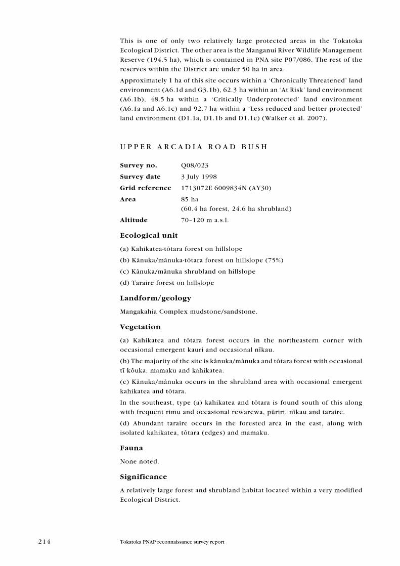
U P P E R A R C A D I A R O A D B U S H
Survey no. Q08/023
Survey date 3 July 1998
grid reference 1713072E 6009834N (Ay30)
area 85 ha
(60.4 ha forest, 24.6 ha shrubland)
altitude 70–120 m a.s.l.
ecological unit
(a) Kahikatea-tötara forest on hillslope
(b) Känuka/mänuka-tötara forest on hillslope (75%)
(c) Känuka/mänuka shrubland on hillslope
(d) Taraire forest on hillslope
Landform/geology
Mangakahia Complex mudstone/sandstone.
Vegetation
(a) Kahikatea and tötara forest occurs in the northeastern corner with
occasional emergent kauri and occasional nīkau.
(b) The majority of the site is känuka/mänuka and tötara forest with occasional
tī köuka, mamaku and kahikatea.
(c) Känuka/mänuka occurs in the shrubland area with occasional emergent
kahikatea and tötara.
In the southeast, type (a) kahikatea and tötara is found south of this along
with frequent rimu and occasional rewarewa, pūriri, nīkau and taraire.
(d) Abundant taraire occurs in the forested area in the east, along with
isolated kahikatea, tötara (edges) and mamaku.
fauna
None noted.
Significance
A relatively large forest and shrubland habitat located within a very modified
Ecological District.
215Tokatoka PNAP reconnaissance survey report
216 Tokatoka PNAP reconnaissance survey report
Representative site for känuka/mänuka-tötara forest, type (b). Approximately
11.4 ha of this site occurs within an ‘At Risk’ land environment and 73.6 ha
within a ‘Critically Underprotected’ land environment (A6.1c) (Walker et al.
2007).
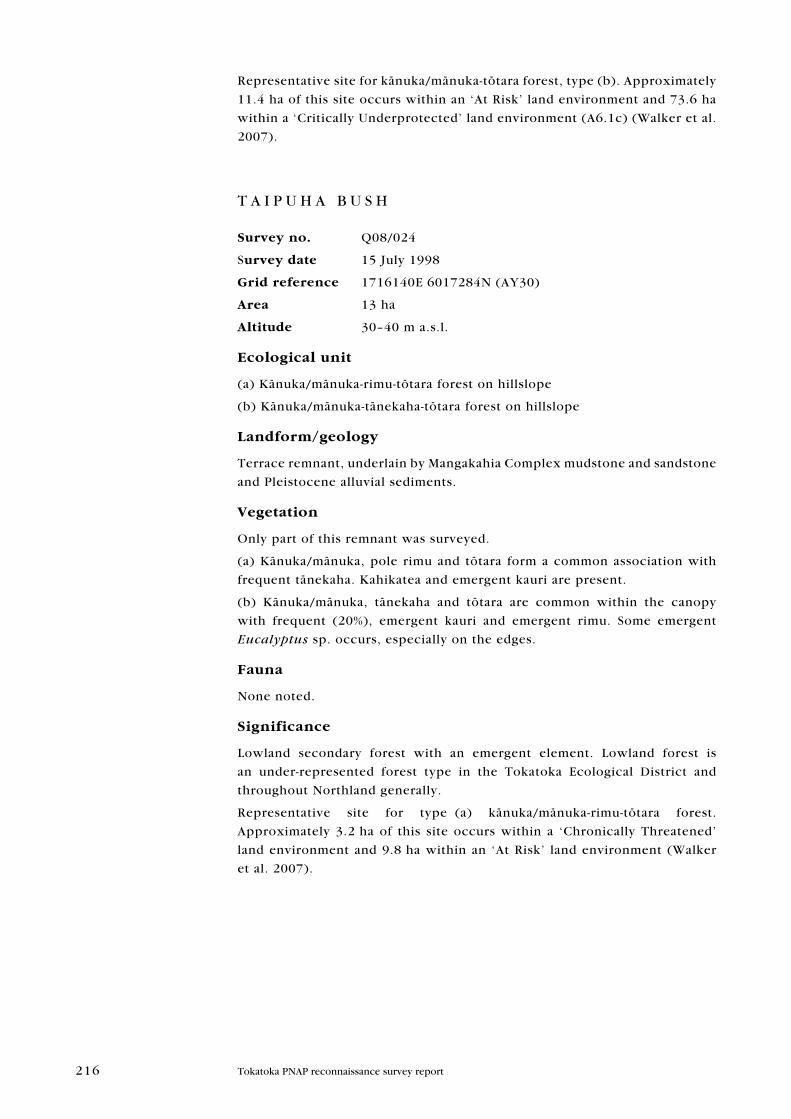
T A I P U H A B U S H
Survey no. Q08/024
Survey date 15 July 1998
grid reference 1716140E 6017284N (Ay30)
area 13 ha
altitude 30–40 m a.s.l.
ecological unit
(a) Känuka/mänuka-rimu-tötara forest on hillslope
(b) Känuka/mänuka-tänekaha-tötara forest on hillslope
Landform/geology
Terrace remnant, underlain by Mangakahia Complex mudstone and sandstone
and Pleistocene alluvial sediments.
Vegetation
Only part of this remnant was surveyed.
(a) Känuka/mänuka, pole rimu and tötara form a common association with
frequent tänekaha. Kahikatea and emergent kauri are present.
(b) Känuka/mänuka, tänekaha and tötara are common within the canopy
with frequent (20%), emergent kauri and emergent rimu. Some emergent
Eucalyptus sp. occurs, especially on the edges.
fauna
None noted.
Significance
Lowland secondary forest with an emergent element. Lowland forest is
an under-represented forest type in the Tokatoka Ecological District and
throughout Northland generally.
Representative site for type (a) känuka/mänuka-rimu-tötara forest.
Approximately 3.2 ha of this site occurs within a ‘Chronically Threatened’
land environment and 9.8 ha within an ‘At Risk’ land environment (Walker
et al. 2007).
217Tokatoka PNAP reconnaissance survey report
218 Tokatoka PNAP reconnaissance survey report
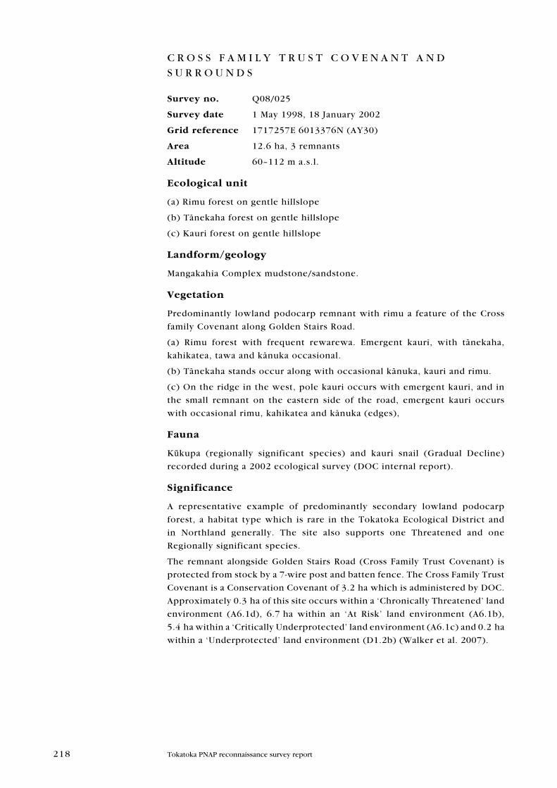
C R O S S F A M I L y T R U S T C O V E N A N T A N D S U R R O U N D S
Survey no. Q08/025
Survey date 1 May 1998, 18 January 2002
grid reference 1717257E 6013376N (Ay30)
area 12.6 ha, 3 remnants
altitude 60–112 m a.s.l.
ecological unit
(a) Rimu forest on gentle hillslope
(b) Tänekaha forest on gentle hillslope
(c) Kauri forest on gentle hillslope
Landform/geology
Mangakahia Complex mudstone/sandstone.
Vegetation
Predominantly lowland podocarp remnant with rimu a feature of the Cross
family Covenant along Golden Stairs Road.
(a) Rimu forest with frequent rewarewa. Emergent kauri, with tänekaha,
kahikatea, tawa and känuka occasional.
(b) Tänekaha stands occur along with occasional känuka, kauri and rimu.
(c) On the ridge in the west, pole kauri occurs with emergent kauri, and in
the small remnant on the eastern side of the road, emergent kauri occurs
with occasional rimu, kahikatea and känuka (edges),
fauna
Kūkupa (regionally significant species) and kauri snail (Gradual Decline)
recorded during a 2002 ecological survey (DOC internal report).
Significance
A representative example of predominantly secondary lowland podocarp
forest, a habitat type which is rare in the Tokatoka Ecological District and
in Northland generally. The site also supports one Threatened and one
Regionally significant species.
The remnant alongside Golden Stairs Road (Cross Family Trust Covenant) is
protected from stock by a 7-wire post and batten fence. The Cross Family Trust
Covenant is a Conservation Covenant of 3.2 ha which is administered by DOC.
Approximately 0.3 ha of this site occurs within a ‘Chronically Threatened’ land
environment (A6.1d), 6.7 ha within an ‘At Risk’ land environment (A6.1b),
5.4 ha within a ‘Critically Underprotected’ land environment (A6.1c) and 0.2 ha
within a ‘Underprotected’ land environment (D1.2b) (Walker et al. 2007).
219Tokatoka PNAP reconnaissance survey report
220 Tokatoka PNAP reconnaissance survey report
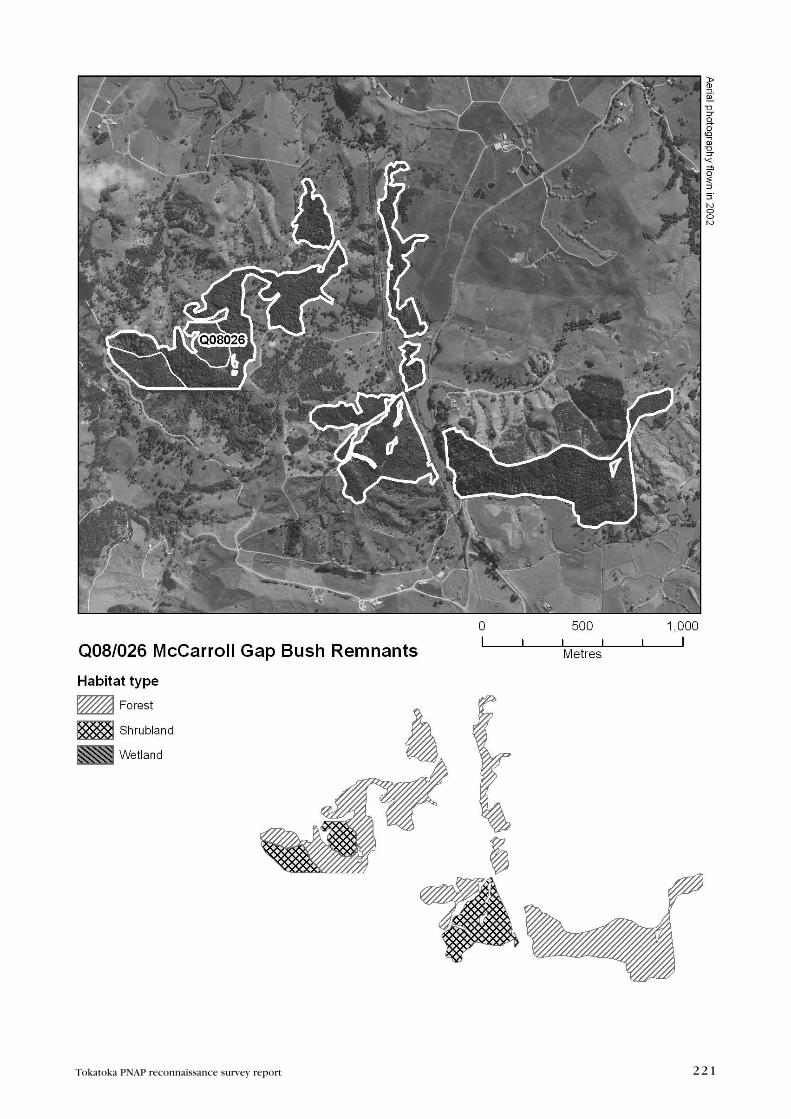
M C C A R R O L L G A P B U S H R E M N A N T S
Survey no. Q08/026
Survey date 15 July 1998
grid reference 1714805E 6011987E (Ay30)
area 88.7 ha, 7 remnants
(68.2 ha forest, 20.5 ha shrubland)
altitude 20–141 m a.s.l.
ecological unit
(a) Tötara forest on alluvium
(b) Tötara forest on hillslope
(c) Kahikatea-tötara forest on toeslope
(d) Tötara-känuka/mänuka forest on hillslope
(e) Gorse-känuka/mänuka shrubland on hillslope
(f) Känuka/mänuka-tötara forest on hillslope
(g) Taraire forest on hillslope
(h) Tītoki-tötara forest on hillslope
Landform/geology
Mangakahia Complex sandstone and mudstone.
Vegetation
(a) The riparian remnant along Kaikowhiti Stream (the northern middle
remnant) comprises abundant tötara with frequent, often emergent, kahikatea.
Tītoki, mataī, pukatea, rimu, töwai and tī köuka are present.
(b) Tötara forest occurs in the forested remnant west of the stream with
frequent kahikatea and occasional rewarewa, rimu, pukatea and känuka/
mänuka.
(c) Kahikatea and tötara are co-dominant in small pockets on the toeslopes
of this with occasional mataī and känuka/mänuka.
Type (b) tötara forest also occurs in the remnant west of this along with
frequent kahikatea and occasional rimu and kauri (ridge).
(d) Abundant tötara with common känuka/mänuka occurs in this area with
occasional kahikatea and isolated emergent pine trees.
(e) Moving south, to the remnant just west of the Paparoa/Oakleigh Road,
gorse and känuka/mänuka shrubland occurs. Mamaku, patë, hangehange,
emergent pine and pampas are occasional.
Type (d) tötara and känuka/mänuka occurs here along with occasional gorse,
mamaku and emergent pine trees.
(f) Känuka/mänuka is abundant with tötara common south of this. Tī köuka,
mamaku, Coprosma sp., gorse, emergent pine trees, Acacia sp. and pampas
(edges) are occasional.
(g) Taraire forest occurs as a patch in this area with frequent rewarewa,
tötara, pukatea, kahikatea and rimu.
221Tokatoka PNAP reconnaissance survey report
222 Tokatoka PNAP reconnaissance survey report
The southern hillface of the remaining remnant, east of Paparoa/Oakleigh
Road (southeastern remnant), is dominated by type (g) taraire along with
frequent rewarewa. Species occurring occasionally include töwai, rimu,
tänekaha, pukatea, tötara, kahikatea and mamaku and nīkau (gullies).
(h) A small area of tītoki and tötara forest occurs by the roadside (< 1%) with
occasional rewarewa and mamaku.
Type (d) tötara occurs on the eastern side of this face along with frequent
kahikatea. Rimu, tänekaha, mamaku and the odd pine tree are present.
Type (c) kahikatea and tötara occur in patches, mainly on the toeslopes, along
with frequent rimu and occasional mataī, rewarewa and känuka/mänuka.
fauna
None noted.
Significance
A collection of remnants over a relatively large area providing important
habitat within a very modified Ecological District. Representative site for type
(g) taraire forest. Sole record of type (h) tītoki-tötara forest in the Tokatoka
Ecological District; however, this ecological unit is not representative
because of its small size.
A Queen Elizabeth II National Trust Open Space covenant protects 12.5 ha of
the remnant on the eastern side of the Paparoa/Oakleigh Road. Approximately
10.8 ha of this site occurs within a ‘Chronically Threatened’ land environment
(G3.1b), 0.7 ha within an ‘At Risk’ land environment (A6.1b) and 77.2 ha
within a ‘Critically Underprotected’ land environment (A6.1c) (Walker et al.
2007).
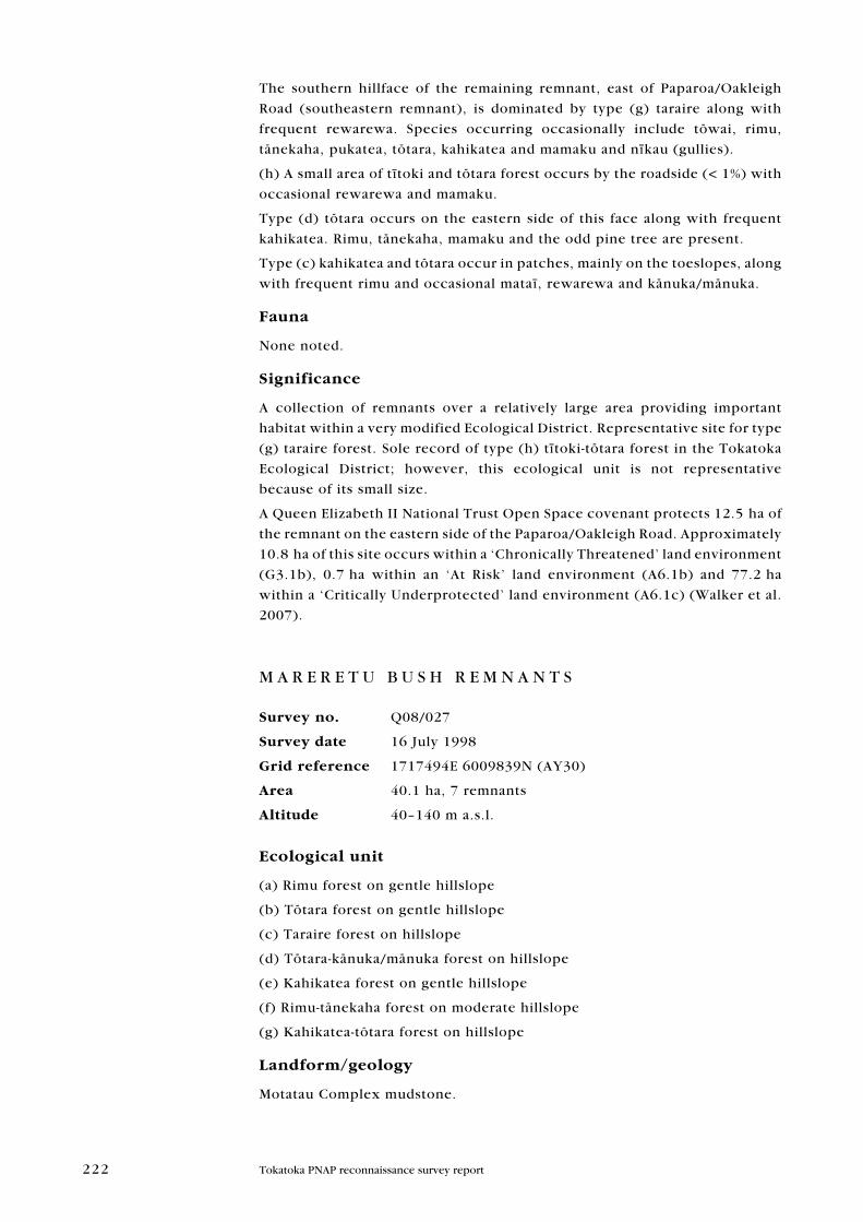
M A R E R E T U B U S H R E M N A N T S
Survey no. Q08/027
Survey date 16 July 1998
grid reference 1717494E 6009839N (Ay30)
area 40.1 ha, 7 remnants
altitude 40–140 m a.s.l.
ecological unit
(a) Rimu forest on gentle hillslope
(b) Tötara forest on gentle hillslope
(c) Taraire forest on hillslope
(d) Tötara-känuka/mänuka forest on hillslope
(e) Kahikatea forest on gentle hillslope
(f) Rimu-tänekaha forest on moderate hillslope
(g) Kahikatea-tötara forest on hillslope
Landform/geology
Motatau Complex mudstone.
223Tokatoka PNAP reconnaissance survey report
224 Tokatoka PNAP reconnaissance survey report
Vegetation
Some of the following ecological unit descriptions have been labelled (1), (2),
(3) etc. with the site map labelled accordingly to show where the described
areas occur.
(1)
(a) Rimu forest is common in the northern remnant on the western side
of Golden Stairs Road. Tötara is frequent and miro, kahikatea, tänekaha,
rewarewa, töwai and taraire are occasional.
(b) Abundant tötara also occurs here along with frequent kahikatea and
occasional rimu, tänekaha, rewarewa and patches of känuka/mänuka.
(c) Taraire also occurs in a small area here along with frequent rewarewa.
Nīkau, rimu, töwai and emergent kauri (ridge) are occasional.
(2)
(d) Towards the south on the western side of the road the vegetation is
tötara and känuka/mänuka with occasional tī köuka, mamaku, kahikatea and
rewarewa.
Type (c) taraire occurs on the southeastern arm of this area along with
frequent rewarewa. Tötara, kahikatea, töwai and puka are occasional.
(3)
Type (b) tötara forest dominates the southwestern remnant. Rimu, kahikatea
and taraire are frequent. Pūriri, rimu, nīkau and kauri are occasional.
(4)
(e) On the eastern side of the road, the small northern remnant is dominated
by kahikatea forest containing frequent tötara. Tī köuka and emergent rimu
are occasional.
(5)
(f) Abundant rimu with common tänekaha occurs in the remnant just south
of this, along with frequent rewarewa. Töwai, känuka/mänuka and tötara
(edges) are occasional.
The small remnant next to this was not surveyed.
(6)
Type (a) abundant rimu occurs in the remaining remnant. Tötara occurs
frequently, along with occasional tänekaha, pukatea, kauri, kahikatea,
känuka/mänuka, nīkau and töwai.
Taraire forest, type (c), also occurs here, along with frequent rewarewa and
some kahikatea, töwai and puka.
(g) Kahikatea is abundant with tötara common on the toeslopes of this
remnant; mataī is occasional.
fauna
None noted.
Significance
A collection of linking forested remnants that provides important stepping
stone habitat within a very modified Ecological District; including a seasonal
food source for the regionally significant kūkupa.
225Tokatoka PNAP reconnaissance survey report
A Queen Elizabeth II National Trust Open Space covenant protects 5.5 ha of
the north western remnant (1).
A representative site for and sole record of rimu-tänekaha forest, type (f) in
the Tokatoka Ecological District. Approximately 29.4 ha of the site occurs
within an ‘At Risk’ land environment (A6.1b) and 10.7 ha within a ‘Critically
Underprotected’ land environment (A6.1c) (Walker et al. 2007).
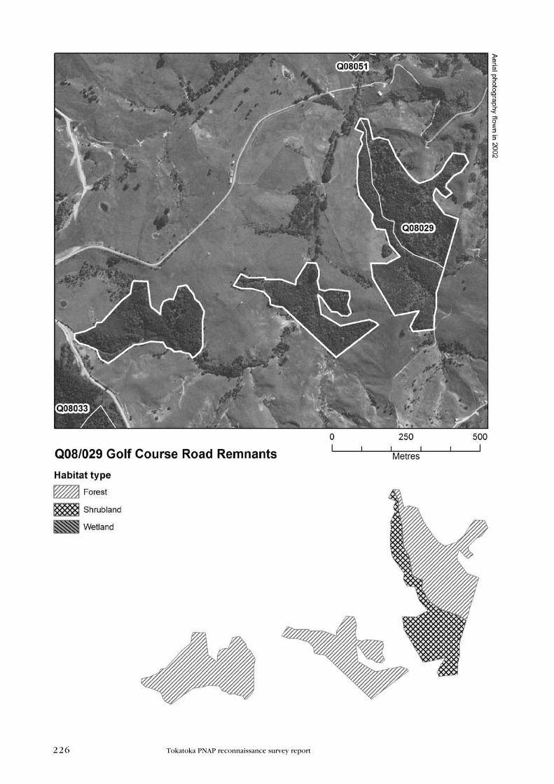
G O L F C O U R S E R O A D R E M N A N T S
Survey no. Q08/029
Survey date 16 July 1998
grid reference 1719961E 6008252N (Ay30)
area 25.2 ha, 3 remnants
(19.3 ha forest, 5.9 ha shrubland)
altitude 60–120 m a.s.l.
ecological unit
(a) Känuka/mänuka shrubland on hillslope
(b) Känuka/mänuka-tänekaha forest on moderate hillslope
(c) Tänekaha-känuka/mänuka forest on hillslope
(d) Rimu forest on hillslope
(e) Kauri forest on hillslope
(f) Tänekaha forest on moderate hillslope
Landform/geology
Mangakahia Complex mudstone/sandstone.
Vegetation
In 1998, the area of this site was mapped as being 44.6 ha, with the eastern
remnant considerably larger in comparison with the site depicted in later
aerial photography.
(a) Abundant känuka/mänuka shrubland occurs in the eastern remnant.
Tötara and tänekaha are occasional.
(b) Känuka/mänuka associated with tänekaha also occurs here along with
frequent tötara. Rewarewa, rimu, tötara, kahikatea and pine trees are present
in small amounts.
(c) On the west-facing hillslope of this remnant, tänekaha is emergent and
dominant over tall känuka/mänuka. Tötara and kauri occur frequently.
Emergent rimu, emergent kahikatea, tī köuka and mamaku are occasional.
Type (b) känuka/mänuka-tänekaha is found in the middle remnant, along
with the odd rewarewa, rimu, tötara, kahikatea and pine tree.
(d) A small pocket of abundant rimu occurs in the remaining remnant adjacent
to Golden Stairs Road. Kauri and känuka/mänuka occur frequently. Tänekaha
and rewarewa are occasional.
(e) Near this, a small area of emergent kauri is present with occasional
tänekaha and rewarewa.
226 Tokatoka PNAP reconnaissance survey report
227Tokatoka PNAP reconnaissance survey report
(f) Common tänekaha also occurs here along with frequent tötara and känuka/
mänuka. Kahikatea and rimu are occasional.
Type (a) känuka/mänuka occurs in a small area by Golden Stairs Road along
with occasional emergent tänekaha and kauri rickers, mamaku and gorse.
Type (b) känuka/mänuka and tänekaha is also found by the roadside with
frequent emergent kauri. Mamaku, tötara and emergent pine are occasional.
fauna
None noted.
Significance
A collection of regenerating remnants providing important stepping stone
habitat within a very modified Ecological District.
Representative site for type (c) tänekaha-känuka/mänuka forest. Approximately
9.5 ha of this site occurs within an ‘At Risk’ land environment (A6.1b) and
15.7 ha within a ‘Critically Underprotected’ land environment (A6.1c)
(Walker et al. 2007).
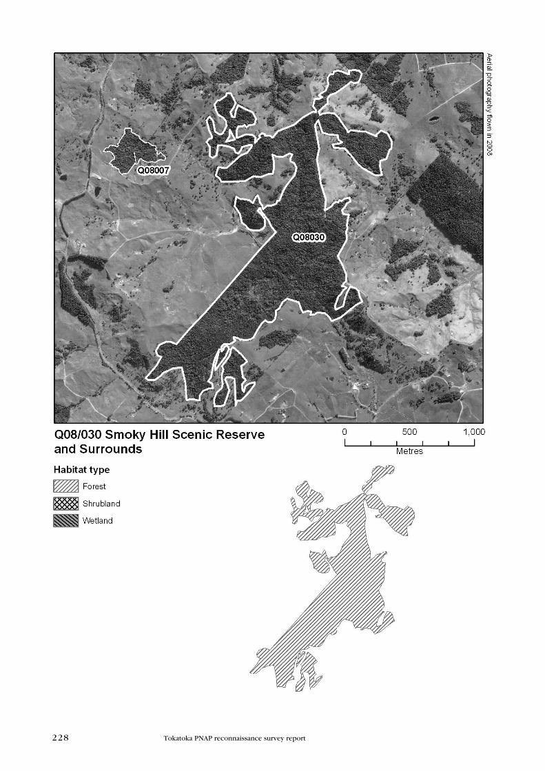
S M O K y H I L L S C E N I C R E S E R V E A N D S U R R O U N D S
Survey no. Q08/030
Survey date 17 April 1998
grid reference 1701123E 6006480N (Ay29)
area 153.8 ha, 2 remnants
altitude 40–141 m a.s.l.
ecological unit
(a) Kahikatea-pūriri forest on hillslope
(b) Tötara forest on ridge
(c) Taraire forest on gentle hillslope
(d) Känuka/mänuka-rimu forest on gentle hillslope
(e) Rimu-tötara forest on gentle hillslope
(f) Undescribed forest on alluvium
(g) Känuka/mänuka forest on gentle hillslope
(h) Känuka/mänuka-kauri forest on gentle hillslope
(i) Kauri forest on gentle hillslope
(j) Känuka/mänuka-rimu-tänekaha forest on gentle hillslope
(k) Tänekaha forest on gentle hillslope
(l) Pūriri-tötara forest on hillslope
(m) Känuka/mänuka shrubland on hillslope
Landform/geology
Mangakahia Complex mudstone forming hill country. Quaternary alluvium
on valley floor.
228 Tokatoka PNAP reconnaissance survey report
229Tokatoka PNAP reconnaissance survey report
Vegetation
Vegetation has been cleared at this site in the very southwestern end of the
large remnant (clearance of 7.9 ha), as shown in a comparison of 2002 and
2008 aerial photography.
(a) Kahikatea-pūriri occurs in the east (edge view), adjacent to the roadside,
with frequent känuka/mänuka and tötara. Tī köuka, pukatea, rimu, rewarewa,
nīkau and lancewood are occasional.
(b) South of this along this eastern boundary, abundant tötara occurs with
frequent rimu and kahikatea. Other species present include lancewood, tī köuka, emergent rewarewa and känuka/mänuka (edges).
(c) Beside this, taraire is dominant with frequent pūriri. Tötara, kauri, tī köuka, rewarewa, mataī and tänekaha are occasional.
Type (b) tötara also occurs southwards along the eastern side. Tänekaha and
pūriri are uncommon and kauri, mamaku, rimu, kahikatea, rewarewa and tī köuka are occasional.
(d) Abundant känuka/mänuka with emergent rimu also occurs here. Mataī, tötara, kahikatea, kauri, rewarewa, tänekaha and tī köuka are all occasional.
(e) In the central area of the remnant on the western side, rimu and tötara are
common with frequent kahikatea and känuka/mänuka. Kauri, mataī, tītoki
and mamaku are occasional.
(f) An area of riverine forest adjoining the upper Te Awaaoteahouhi Stream
with tongues of locally abundant raupö, some purei, and harakeke was
recorded in the northern area of the scenic reserve in a 1993 survey of the
site. This survey contributed to a successful application to the then Forest
Heritage Fund (now called Nature Heritage Fund) to purchase and protect
from development what is now known as Smoky Hill Scenic Reserve.
(g) Känuka/mänuka forest also occurs here with occasional emergent kauri,
emergent tänekaha and kahikatea.
(h) Känuka/mänuka and emergent kauri forest are co-dominant near this.
Emergent tänekaha occurs frequently. Several other emergent species occur
occasionally, including rimu, mataī, tötara, rewarewa and kahikatea. Tī köuka
is also present.
(i) To the east of this, emergent kauri is abundant with frequent rimu. Other
species present include kahikatea, tötara, pūriri, tänekaha and känuka/
mänuka.
(j) South of this central area, emergent rimu, tänekaha and känuka/mänuka
are associated. Occasional species include kauri, tötara and kahikatea, all of
which are emergent.
(k) Southwards along the western edge, tänekaha is abundant with frequent
rimu and känuka/mänuka. Emergent kauri, tötara and kahikatea are
occasional.
(l) Pūriri and tötara are co-dominant in the southern area with frequent
kahikatea and taraire. Occasional species include rimu, pukatea, rewarewa,
tī köuka and lancewood.
(m) By the roadside in the southern end, a band of känuka/mänuka shrubland
occurs with occasional tī köuka, lancewood, tötara, mamaku and nīkau.
230 Tokatoka PNAP reconnaissance survey report
Significant flora
1993 record of the arboreal orchid Adelopetalum tuberculatum (Naturally
Uncommon) (DOC Bioweb).
Regionally significant species: 1993 SSBI Q08/H009 records of pökäkä,
kaikömako and weeping mäpou and 1995 record of Raukaua anomalus
(AK 228982).
fauna
records from SSbi Q08/H009: 1994 record of NI brown kiwi (egg found
in burrow) (Nationally Vulnerable). 1992 record of kūkupa (regionally
significant species), morepork, NZ kingfisher, grey warbler, NI fantail, tūī, and silvereye.
1992 record of kauri snail (Gradual Decline) and copper skink.
Significance
Within the Tokatoka Ecological District, Smoky Hill Scenic Reserve and
Surrounds represents a significant forested habitat in size and ecological
attributes, including many representative forest types and Threatened,
At Risk and Regionally significant species. NI brown kiwi were last recorded
in 1994 and it is possible they may still occur there. Follow-up survey is
recommended.
Representative site for vegetation types (b), (c), (d), (e), (g), (h), (i), (j) and
(k).
Approximately 41.3 ha of this site is protected by Smoky Hill Scenic Reserve
which is administered by DOC. This site occurs within an ‘At Risk’ land
environment (A6.1b) (Walker et al. 2007).
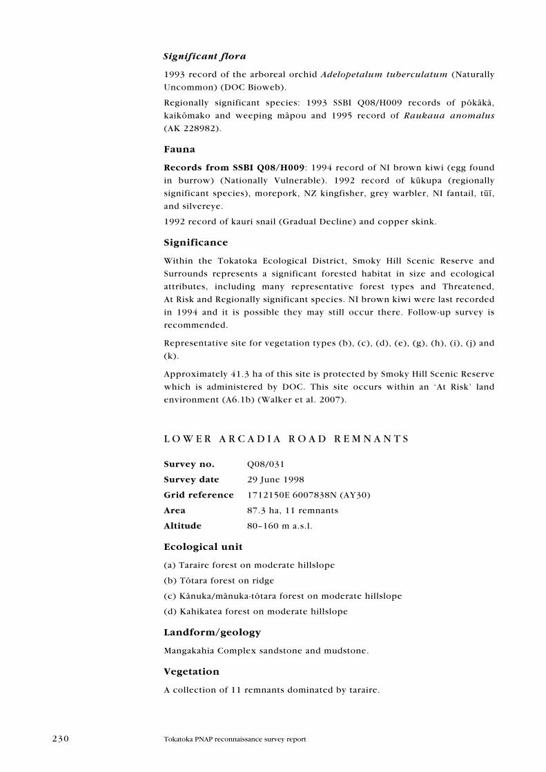
L O W E R A R C A D I A R O A D R E M N A N T S
Survey no. Q08/031
Survey date 29 June 1998
grid reference 1712150E 6007838N (Ay30)
area 87.3 ha, 11 remnants
altitude 80–160 m a.s.l.
ecological unit
(a) Taraire forest on moderate hillslope
(b) Tötara forest on ridge
(c) Känuka/mänuka-tötara forest on moderate hillslope
(d) Kahikatea forest on moderate hillslope
Landform/geology
Mangakahia Complex sandstone and mudstone.
Vegetation
A collection of 11 remnants dominated by taraire.
231Tokatoka PNAP reconnaissance survey report
232 Tokatoka PNAP reconnaissance survey report
The following ecological unit descriptions have been labelled (1), (2), (3)
etc. with the site map labelled accordingly to show where the described
areas occur.
(1)
(a) Remnant (1) is 70% taraire dominant. Rewarewa is frequent. A range
of species occur occasionally including, pūriri, rimu, pukatea, tötara, puka,
northern rätä and töwai.
(b) On the upper slopes of this remnant, tötara forest occurs along with
occasional kahikatea.
(c) In the northern end, by the roadside, känuka/mänuka and tötara are
common. Rewarewa, kahikatea, tī köuka and mamaku are occasional.
(2)
Across the road, type (a) taraire forest also occurs in this remnant. Rimu,
tötara, puka, kahikatea and töwai are occasional.
Type (c) känuka/mänuka and tötara is present with occasional kahikatea and
tī köuka.
(3)
Remnant (3) is also type (a), abundant taraire. Rimu, kahikatea, mataī, pukatea,
töwai, nīkau, tötara (edges) and känuka/mänuka (edges) are occasional.
(4)
Southwards, this remnant is 95% type (a) taraire, with frequent rewarewa.
A large mature kauri defines this remnant. Other species present include
occasional rimu, kahikatea, tītoki, pūriri, puka, nīkau and tötara (edges).
Remnant (5) was not described during this survey.
(6)
Type (a) taraire is dominant in remnant (6).
(7)
Type (a) also occurs in the remnant cornering Arcadia Road and Porter Road,
(vii). Rewarewa is frequent and pukatea, kahikatea, pūriri and nīkau are
present in small amounts.
(d) Kahikatea is common (5%) in a small area in the northern end of remnant
(7), along with frequent rewarewa. Rimu, pūriri, tī köuka and tötara occur
occasionally.
(8)
Taraire dominant, vegetation type (a). Rewarewa is frequent and pukatea,
nīkau, kahikatea, pūriri, rimu and tötara (edges) are occasional.
(9)
Not described during this survey.
(10) and (11)
The vegetation in the remaining remnants in the southwest—(10) and (11)—
is type (a) taraire dominant, with a range of occasional species including
kahikatea, rewarewa, pukatea, pūriri, rimu, tötara, and nīkau.
A ribbon of tötara is present in the western remnant.
Significant flora
Northern rätä (regionally significant species) recorded during this survey.
233Tokatoka PNAP reconnaissance survey report
fauna
Kūkupa (regionally significant species) were recorded on the day of survey
and a local resident at the time commented on the abundance of kūkupa in
the area.
Significance
A collection of taraire-dominant remnants within a very modified Ecological
District providing important stepping stone habitat, including a seasonal
food source for the regionally significant kūkupa.
Representative site for type (a) taraire forest.
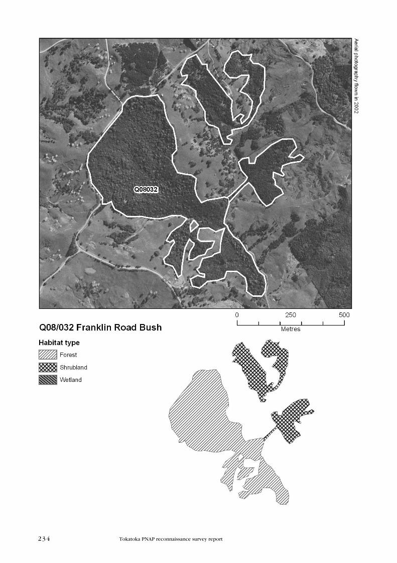
F R A N K L I N R O A D B U S H
Survey no. Q08/032
Survey date 12 August 1998
grid reference 1710454E 6005802N (Ay30)
area 41.2 ha, 2 remnants
(29.2 ha forest, 12.1 ha shrubland)
altitude 50–100 m a.s.l.
ecological unit
(a) Taraire forest on moderate hillslope (70%)
(b) Rimu forest on moderate hillslope (5%)
(c) Kahikatea forest on hillslope (5%)
(d) Kauri forest on hillslope (< 1%)
(e) Känuka/mänuka-rimu-tötara forest on gentle hillslope (< 1%)
(f) Känuka/mänuka shrubland on gentle hillslope (20%)
Landform/geology
Mangakahia Complex sandstone and mudstone.
Vegetation
(a) The forested remnant is dominated by taraire, with frequent rewarewa.
Species occurring occasionally include emergent rimu with kahikatea, töwai,
pūriri, nīkau, puka and tötara.
(b) There is a small pocket of common pole rimu with frequent tötara and
känuka/mänuka. Emergent kauri with kahikatea, tänekaha, rewarewa and
nīkau are occasional.
In the southeastern part of this remnant:
(c) Kahikatea is common in a small area with occasional rimu, rewarewa,
pukatea, pūriri, nīkau and tī köuka.
(d) A small area of dominant emergent kauri occurs with frequent rimu.
Tötara and känuka/mänuka occur on the edges.
(e) Känuka/mänuka-rimu and tötara are co-dominant with occasional emergent
kauri rickers.
(f) The shrubland areas are dominated by känuka/mänuka, often with frequent
tötara. Mamaku, tī köuka, patë and the odd pine tree are also present.
234 Tokatoka PNAP reconnaissance survey report
235Tokatoka PNAP reconnaissance survey report
fauna
The forested area of this site was surveyed by the NZ Wildlife Service, Fauna
Survey Unit in 1977 (SSBI Q08/H012); however, no fauna observations were
made.
Significance
This site is dominated by a relatively large representative taraire forest
remnant providing important stepping stone habitat, including a seasonal
food source for the regionally significant kūkupa within a very modified
Ecological District.
In 1977 it was noted that the taraire remnant was being grazed by stock
and, as a result, groundcover species were absent (SSBI Q08/H012). This
site occurs within a ‘Critically Underprotected’ land environment (A6.1a and
A6.1c) (Walker et al. 2007).
W A I K O P I K O P I K O S T R E A M R E M N A N T S
Survey no. Q08/033
Survey date 20 July 1998
grid reference 1718813E 6007241N (Ay30)
area 46.6 ha
(20.1 ha forest, 26.5 ha shrubland)
altitude < 60–140 m a.s.l.
ecological unit
(a) Känuka/mänuka-tötara shrubland on moderate hillslope (50%)
(b) Känuka/mänuka-tötara forest on moderate hillslope
(c) Kauri forest on moderate hillslope
(d) Tötara forest on moderate hillslope (25%)
Landform/geology
Mangakahia Complex mudstone/sandstone.
Vegetation
(a) Abundant känuka/mänuka with associated tötara occurs in the shrubland
area in the east. Occasional species include mamaku and some emergent
pine.
The forest on the hillslope adjacent to the south of this comprises several
frequently occurring species including töwai, mamaku, rewarewa, kahikatea
and tötara. Other species present include taraire, kohekohe, puka, nīkau, and
känuka/mänuka.
(b) Tötara and känuka/mänuka is common in approximately 10% of the
forested area in the western side of the remnant, with
(i) Frequent emergent tänekaha and occasional emergent kauri, rimu,
rewarewa and kahikatea.
(ii) Occasional rewarewa, tänekaha, rimu, mamaku and tī köuka.