Embed Size (px)
Citation preview

WA
SH
ING
TO
N N
AT
UR
AL
HE
RIT
AG
E P
RO
GR
AM
Riparian Vegetation Classification of theColumbia Basin, Washington
Prepared for Bureau of Land Management , Spokane District
and The Nature Conservancy
Prepared byRex C. Crawford Ph.D.
March 2003
Natural HeritageReport 2003-03

A RIPARIAN VEGETATION CLASSIFICATION OF THE COLUMBIA BASIN, WASHINGTON
Rex C. Crawford Ph.D.
Washington Natural Heritage Program Washington Department of Natural Resources
Olympia, WA 98504-7016
In coordination with:
Bureau of Land Management, Spokane District The Nature Conservancy
March 2003

ii
SUMMARY This report summarizes the results of a four-year project to inventory the riparian vegetation of Washington’s Columbia Basin and to develop a riparian vegetation classification for the area. The Bureau of Land Management, Spokane District, and The Nature Conservancy funded this phase of the project. Previous inventory was funded by the BLM, Environmental Protection Agency and the Washington Department of Natural Resources. Sample sites included valley segments on public land and on land owned by cooperating private land owners. Riparian samples are located along one hundred nineteen stream reach locations. A stream/riparian reach or reaches that typified each valley segment was characterized by eighteen stream variables or ratings. Each stream reach was mapped in vertical profile and as a horizontal map. Eleven physical variables and a plant species list with cover estimates were collected in plots on representative fluvial surfaces at each reach. Table 1 lists the most frequently sampled vascular plant species recorded during inventory by their life form, native or introduced status, and U.S. F.W.S. Region 9 hydrologic status, erosion control potential, short-term and long-term revegetation ability, forage for cattle, and potential to provide cover for mule deer, upland game birds, and waterfowl. Analysis of vegetation and environmental data collected at three hundred forty-seven sites derived ninety-eight vegetation types. Each type is briefly described including its affinity to the existing national vegetation classification and sources of management recommendation for the type. Types are of existing vegetation and are related to potential vegetation whenever information is available. Acknowledgements: Bureau of Land Management (BLM) cost-share project (HWP010033) and The Nature Conservancy, Washington Field Office. EPA previously provided funds for sampling Adams and Lincoln Counties as part of their Columbia Plateau Agricultural Initiative. BLM previously provided funds to characterize the their natural resource base in Douglas, Grant and Lincoln County. DNR provided funds for sampling in southeastern Washington. Mike Marsh formerly of EPA initiated that agency’s support for this project and deserves special recognition. Gary Devore, Adams County Conservation District, and Tom Platt, WSU Cooperative Extension-Lincoln County provided invaluable administrative and logistic support for inventory in their counties. Chuck and Nancy Warner, TNC, not only provided funding but maps, support and a restful night. Todd Thompson of the BLM has helped this project in shepherding funding through his agency and providing both sites and personal insights in the interpretation of stream and riparian function in the Columbia Basin. Calib Baldwin who collected plot and stream information in southeast Washington deserves special recognition. Thanks to Steve Farone and Doreen Smith for the report cover design. Much appreciation is extended to Chris Chappell for classification discussions and to John Gamon for his edits, patience and support. Citation: Crawford. Rex C. 2003. Riparian vegetation classification of the Columbia Basin, Washington. Natural Heritage Program Report 2003-03. Washington Dept. Natural Resources. Olympia, WA. 118 pp.

iii
Table of Contents page INTRODUCTION.........................................................................................................................................................1 METHODS....................................................................................................................................................................1 RESULTS AND DISCUSSION....................................................................................................................................3 KEY TO RIPARIAN AND WETLAND VEGETATION TYPES ON THE COLUMBIA PLATEAU, WASHINGTON ..........................................................................................................................................................15 Quaking aspen and Black cottonwood riparian types..................................................................................................24
Quaking aspen / redosier dogwood association .......................................................................................................24 Quaking aspen / common snowberry association....................................................................................................25 Black cottonwood/snowberry association................................................................................................................26 Black cottonwood-Rocky mountain juniper community type .................................................................................27 Black cottonwood/redosier dogwood association....................................................................................................27 Black cottonwood-water birch/mockorange community type .................................................................................27 Black cottonwood/sandbar willow association........................................................................................................27
Oregon white oak types: ..............................................................................................................................................28 Oregon white oak / Lewis’ mockorange-common snowberry community type ......................................................28
White Alder riparian types: .........................................................................................................................................29 White alder/common horsetail community type......................................................................................................29 White alder/Lewis’ mockorange association ...........................................................................................................30 White alder/water birch association.........................................................................................................................31 White alder/netleaf hackberry association ...............................................................................................................31
Conifer tree-dominated riparian types: ........................................................................................................................32 Ponderosa pine / common snowberry floodplain association ..................................................................................32 Western juniper / mockorange community..............................................................................................................32 Western juniper / big sagebrush/ bluebunch wheatgrass association.......................................................................32
Thinleaf Alder and Water birch types: ........................................................................................................................38 Thinleaf alder / redosier dogwood association ........................................................................................................38 Water birch / redosier dogwood association............................................................................................................39 Water birch / Common snowberry community type................................................................................................40 Water birch / Wood’s rose association ....................................................................................................................41 Water birch / mockorange association.....................................................................................................................42 Thinleaf alder/yellow willow community type........................................................................................................43 Water birch / common horsetail community type....................................................................................................43
Black hawthorn types: .................................................................................................................................................44 Black hawthorn / common snowberry plant association .........................................................................................44 Black hawthorn / Woods’ rose association..............................................................................................................45 (Quaking aspen) - Black hawthorn / cowsparsnip plant association........................................................................46
Other Shrub types: .......................................................................................................................................................47 Redosier dogwood association ................................................................................................................................47 Woods' or Nootka rose community type..................................................................................................................48
Exotic tree and shrub types:.........................................................................................................................................49 White willow community type ................................................................................................................................49 Boxelder community type........................................................................................................................................49 Indigobush community type ....................................................................................................................................49
Willow types:...............................................................................................................................................................50 Yellow willow/ redosier dogwood community type................................................................................................50 Yellow willow- Sandbar willow community type ...................................................................................................51 Sandbar or coyote willow association .....................................................................................................................52 Arroyo willow community type...............................................................................................................................53 Peachleaf willow community type...........................................................................................................................54 Bebb willow community..........................................................................................................................................54
Dry-site short tree and shrub types: .............................................................................................................................55 Netleaf hackberry / mockorange community type...................................................................................................55 Mockorange / Common snowberry plant association..............................................................................................56 Mockorange / Western white clematis community type..........................................................................................57

iv
Common chokecherry community type...................................................................................................................58 Saskatoon serviceberry – Lewis’ mockorange / bluebunch wheatgrass community type .......................................59 White sagebrush community type............................................................................................................................60 Saskatoon serviceberry/western poison ivy community type ..................................................................................61 Smooth sumac association.......................................................................................................................................61
Grass-like Wet Meadow and Riparian Vegetation Types............................................................................................64 Woolly sedge – silverweed cinquefoil community type..........................................................................................64 Woolly sedge – common spikerush community type ..............................................................................................65 Northwest Territory sedge association ....................................................................................................................66 Nebraska sedge - silverweed cinquefoil community type........................................................................................67 Common spikerush association ...............................................................................................................................68 Baltic rush - silverweed cinquefoil community type ...............................................................................................69 Hard-stem bulrush association.................................................................................................................................70 Water sedge community ..........................................................................................................................................71 Wooly sedge- Analogue sedge community type .....................................................................................................71 Baltic rush community.............................................................................................................................................71 River bulrush community ........................................................................................................................................71
Grass Riparian Types...................................................................................................................................................74 Fowl mannagrass association .................................................................................................................................74 Reed canarygrass association ..................................................................................................................................75 Water foxtail community type .................................................................................................................................76 Bentgrass community type ......................................................................................................................................77 Quackgrass community type....................................................................................................................................78 Tufted hairgrass community type ............................................................................................................................79 Intermediate wheatgrass pasture..............................................................................................................................79 Prairie Cordgrass community type ..........................................................................................................................79
Salt Meadow Riparian Vegetation Types ....................................................................................................................81 Black greasewood / Saltgrass association................................................................................................................81 Saltgrass - Clustered field sedge community type ...................................................................................................82 Saltgrass - Chairmaker’s bulrush community type ..................................................................................................83 Alkali cordgrass association ....................................................................................................................................84 Basin wildrye-Saltgrass association.........................................................................................................................85 Basin wildrye - clustered field sedge association ....................................................................................................86 Basin wildrye - cheatgrass community type ............................................................................................................87 Annual hairgrass - curlycup gumweed community type .........................................................................................88 Bluebunch wheatgrass community type ..................................................................................................................89
Forb Riparian Types ....................................................................................................................................................91 Common Horsetail community type........................................................................................................................91 Gray’s biscuitroot community type .........................................................................................................................92 Watercress community type ....................................................................................................................................93 Broadleaf cattail association ....................................................................................................................................94 Broadfruit burreed community ................................................................................................................................95 Broadleaved pepperweed.........................................................................................................................................95 Whitewater crowfoot community ...........................................................................................................................95 Canadian waterweed community............................................................................................................................95
Columbia Basin Riparian Associations not sampled ...................................................................................................96 References ...................................................................................................................................................................97 Figures and Tables: page Figure 1. Illustration of relative positions of fluvial surfaces…………………………………………………………2 Figure 2. Calculation of Flood Potential Index…………………………………………………………………….….3 Figure 3. Distribution of sample reaches……………………………………………………………………………...6 Table 1. Species Names………………………..……………………………………………………………………..7 Table 2. Species revegetation and habitat characteristics…………………………………………………………...10 Appendix A. Constancy and average cover of species………………………………………………………………99

1
INTRODUCTION
Riparian and wetland vegetation classifications provide integrated information systems that help in communication and interpretation of current land use, in definition of desired futures, and in comparison and monitoring for improving management. This report documents a four-year project to develop a riparian vegetation classification for the Columbia Basin in Washington. This Columbia Plateau riparian vegetation classification provides:
1) A guide to the riparian and wetland vegetation of Washington’s Columbia Basin withinformation on fluvial, geomorphological, and land use processes,
2) An information source on the relationship between riparian vegetation and water quality,runoff and habitat for wildlife and livestock, and
3) A riparian restoration and management guide and a baseline for monitoring change.
Riparian or streamside environments are critical linkages and transition zones between the upland and the aquatic environments. Riparian zones provide a variety of ecosystem functions, such as wildlife habitat, contribution to fish habitat, unique plant species habitat, improving flood control, and sediment trapping. Lowrance et al. (1985) documented how riparian vegetation controlled agricultural non-point-source pollution stressors to the environment. The riparian and wetland zone is vitally important to the livestock industry because it provides more and higher quality forage than the adjacent uplands. Improper grazing in riparian zones changes riparian vegetation and contributes to altered water quality, sediment flow and other environmental stressors.
Variability within the riparian zone has been recognized and cataloged by classifying its vegetation (Kovalchik 1987, 2001, Manning et al. 1996, Hansen et al. 1995). Each vegetation unit has its own characteristics and contributes in its own way to maintaining a healthy riparian and stream ecosystem (Crowe and Clausnitzer 1997). Classification of riparian vegetation in relation to fluvial surfaces in a particular watershed will give targets for restoration or mitigation projects. Previous riparian vegetation classification in the Columbia Basin was limited and at a coarse scale (Cowardin et al. 1979, Evans 1989, Daubenmire 1970).
METHODS
Sampling of riparian vegetation and its associated environment follows procedures for riparian characterization developed by a coalition of governmental and private organizations in Montana (Hansen et al. 1995), the forests of eastern Washington (Kovalchik 1992, 2001) and the rangeland and forests of northern Nevada (Manning and Padgett 1996). The inventory scheme is designed to sample across the variation in stream and riparian ecosystems (Reid and Bourgeron 1993).
Major drivers identified as determinants of riparian vegetation are valley gradient, geology, and landuse. Accurate or complete GIS covers of the latter factors were not available at the beginning of this project. The distribution of public land was assumed to capture the variation in geology and landuse across the county and was used as a surrogate for those factors. Public land combined with three valley gradient classes derived from a Department of Natural Resources hydrology layer were used to initially stratify sample locations.

2
Stream reaches selected for sampling were first assessed as to their representativeness of the valley’s disturbance history and hydrology. After a walking reconnaissance of the valley, a representative reach was selected for sampling and located on an orthophoto map. A preliminary horizontal map was sketched illustrating observed fluvial surfaces with associated vegetation and land use. Using a modified Rosgen (1996) method of stream characterization, stream, valley, and environmental features were recorded and a stream profile was drawn to display the relationship of surfaces to field determined bankfull (Figure 1). The following information were collected at each stream reach: bankfull, bankfull width, average stream depth and maximum depth, floodprone width (measured at twice maximum depth from channel bottom), stream gradient, Rosgen stream type, influence of spring, seep, and sub-irrigation. Each stream was characterized as ephemeral, intermittent, or perennial as illustrated on recent USGS maps.
Figure 1. Illustration of relative positions of fluvial surfaces recorded for location of each vegetation plot.
The following information was recorded to characterize each representative fluvial surface and its vegetation: 1) the distance from the channel at bankfull, 2) elevation above bankfull at plot center, 3) current land use, 4) thickness, texture and Munsel color of surface soil layers and where possible, characters of subsurface soil as to depth to redox layer, restrictive layer, or water table, and 5) a complete plant list by lifeform and species cover. Horizontal and vertical distances for stream profiles were determined by a tape measure and climometer. Woody plants that can typically grow into a tree with single trunk over 5 inches diameter at 4.5 feet from the

3
ground (DBH) were recorded as overstory trees and as understory trees when less than 5 inches DBH. Plot size for vegetation varied with size of dominant plants and size and shape of fluvial surface. Plot size in tree-dominated communities varied between .02 and .1 acre, .01 and .1 acre for shrublands and .001 and 0.1 acre for herbaceous vegetation. Vegetation and site data were analyzed using TWINSPAN and cluster analysis using the PC-ORD analytical package (McCune and Mefford 1997). Description and comparison of vegetation units with stream and site variables included deriving a Flooding Potential Index or FPI (Chappell 1999). FPI is calculated for each fluvial surface sampled by dividing its elevation above bankfull by maximum stream depth above bankfull (Figure 2). FPI places each site in a relative vertical position above the stream channel or relative to the floodprone area.
Figure 2. Stream measurements following Rosgen (1996) for field determined bankfull, which is the level of incipient flooding, and the floodprone zone defined as twice the maximum depth.
RESULTS AND DISCUSSION Geologic setting. The Columbia Basin is underlain by 7 to 17 million year old basalt layers that fill a basin between the Cascade and Rocky Mountains. During the Pleistocene, 1 million to 10,000 years ago, glaciers intermittently covered the land north of most of the Columbia Basin. A lobe of that ice would sometimes dam a river in the northern Rockies (the Clark Fork River in Montana) and create a large lake that is now referred to as Lake Missoula. The ice dam formed and was breached or was broken-up as many as one hundred times, each time sending a torrent of water, ice and debris across the Columbia Basin Washington that eventually reached the Pacific Ocean through the Columbia River gorge. These catastrophic floods cut deep canyons and coulees in the basalt layers and deposited vast amounts of sand, gravel and boulders. The material sometimes partially filled canyons previously cut in the basalt. Finer material left after

4
the floods were deposited in the Quincy and Pasco Basins. After the water receded and the sediments dried, they were blown northeastward to partially or completely cap exposed basalt and flood deposits with sand and silt. These wind blown deposits are now the deep, productive soils of the Palouse and adjacent areas (Alt and Hyndman 1984, Stoffel et al.1991). Northern Douglas County is the only portion of the Columbia Plateau that was overridden by glaciers. This area at the edge of the Columbia River basalts additionally was also inundated by glacial meltwater lakes dammed up behind the Okanogan lobe of the continental glacier. The upper valley reaches are similar to other loess covered portions of the Columbia Basin except it is mixed with till. Additionally, underlying granodiorite is exposed near the Columbia River Canyon where it merges with the Okanogan river valley (Stoffel et al.1991). Upland vegetation setting. The Columbia Basin supports a complex landscape composed of: native shrubsteppe vegetation composed of scattered shrubs, typically sagebrush species or bitterbrush with a bunchgrass cover, usually bluebunch wheatgrass, Idaho fescue or needlegrasses, scablands (shallow rocky soils) that support specialized vegetation dominated by stiff sagebrush, one of several bushy buckwheats, and short bunchgrasses, and land largely converted to agricultural use or rangeland dominated by exotic plants or native vegetation tolerant of persistent land use. Daubenmire (1970) describes the pre-agricultural vegetation landscape and Vander Haegen et al. (2000) describe the current landscape condition of the Columbia Basin of Washington. Hydrologic setting. The Columbia Basin proper (the area bounded by the Columbia and Snake River canyons and the Rocky Mountain foothills) has four major watersheds: Crab Creek, Douglas Creek including McCartney Creek, and Foster Creek that all flow to the Columbia River and the Palouse River that flows to the Snake River. The Palouse River drains the foothills of the northern Rockies and the adjacent Columbia Basin plateau. Snowmelt and winter rain dominate the watershed. Cow Creek, a Palouse tributary, is the only part of that watershed sampled and the only part with significant dams, ditches and dikes. Upper Crab Creek originates along the breaks above the Columbia River canyon in northeastern Spokane County and flows southwestward to Wilson Creek in Grant County. Upper Crab Creek is dominated by a multitude of springs, snowmelt and winter rain. From Wilson Creek, Crab Creek flows south into Moses Lake. Lower Crab Creek dominates the natural watershed of Grant County although the Columbia River Irrigation Project (CRIP) is the dominant hydrologic driver of much the county. Much of northern Grant County is the Grand Coulee, a major ice age flood channel that prior to CRIP supported a series of internally drained lakes. Today, Banks Lake reservoir is now at the head of Grand Coulee and provides water via a canal system to the irrigated agriculture landscape of central Grant County. Seepage from Banks Lake feeds the lakes south in Grand Coulee. Crab Creek and CRIP parallel each other and interact below Billy Clapp Reservoir. Wasteways (surface irrigation water re-entering the natural watershed) generally flow into narrow, steep valleys although they may be held as “pothole lakes” in broad flat valleys. These wasteway creeks have seasonal and daily flood patterns not found in native watersheds. Lower Crab Creek from Corfu to the Columbia River flows through a broad, flat valley with wasteway creeks entering along its north side.

5
Douglas and McCartney Creeks drain most of Douglas County southward through Moses Coulee into the Columbia River. Snowmelt, winter rain and springs dominate this watershed. Upper Douglas Creek is not dammed although it is confined within its narrow valley by railroad and road grades and is ditched in the lower reaches. The western portion of the watershed drains Badger Mountain, a local up-lift of Grande Ronde basalt. Generally, upper reaches of the Badger Mountain watershed are in steep gradient, narrow valleys while the lower reaches are in narrow, mid to low gradient valleys before joining the mainstem of Douglas Creek. Although McCartney Creek drains Jameson Lake, the only portions that have surface water are spring-fed. Douglas Creek recently has experienced a series of rain-on-snow flash flood events that scoured the much of the creek’s flood plain. Foster Creek drains northern Douglas County, the only glaciated portion of the Columbia Plateau, and flows north into the Columbia River. Snowmelt, winter rain and springs dominate this watershed. It is not dammed and comparatively only a few reaches are ditched or diked. The upper valley reaches are similar to other loess covered portions of the Columbia Basin except it is mixed with till. The mid reaches flow through generally broad low gradient valleys with Pleistocene lake deposits. The lower reaches are in narrower, steeper valleys cutting through a mix of exposed deep gravelly flood deposits and exposed granodiorite near the Columbia River Canyon where the Okanogan river valley merges. Watersheds that originate in the Blue Mountains and the east Cascades and flow through the arid Columbia Basin into the Snake and Columbia Rivers are dominated by snowmelt although spring reaches are not uncommon. Land Use Setting. Dryland farming and irrigation agriculture and hay production are primarily found on deep fine textured soils occupying over 50% the basin. The rest of the basin, primarily shallow or rocky soils, supports or was used to support livestock. Population centers are generally small and typically associated with water features, for example, Moses Lake and the tri-cities on the Columbia River. Riparian Species List and Species Characteristics. Table 1 lists vascular plant species commonly encountered during vegetation sampling (>5% of plots or indicator value) by their lifeform, native or introduced status, and U.S. F.W.S. Region 9 hydrologic status. A total of 445 species were included in all samples. Common and scientific names are those listed in the U.S.D.A. Plants Database (http://plants.usda.gov/plants). Synonyms used in Hitchcock and Cronquist (1973) appear in Table 1. Table 2 lists the erosion control potential, short-term and long-term revegetation ability, forage for cattle, and potential to provide cover for mule deer, upland game birds, and waterfowl for selected species. Sources for this information are Hansen et al. (1995) and Crowe and Clausnitzer (1997). Riparian Vegetation Classification. Analysis of vegetation and environmental data from 347 plots in 119 riparian settings derived 98 vegetation types (Figure 3). These are existing-vegetation types and they are related to potential vegetation types when information is available. Each type is briefly described including its geographic distribution, fluvial setting, vegetation, and previous classification including its affinity to the existing national vegetation classification or NVC (Anderson et al. 1998), and sources of management recommendations. A vertical

6
stream profile illustrates the relationship between fluvial surface and plant community type. Fluvial surfaces are depicted in relation to field-determined bankfull and the floodprone zone as defined by Rosgen (1996). Each profile indicates the measured distance of each surface above and below bankfull and its horizontal width. Each description lists: 1) common plants in the community type with average cover and constancy or percent of plot they occurred in, and 2) environmental features of the type.
Figure 3. Distribution of sample reaches (+) and major drainages of the Columbia Basin, Washington. Types are grouped first by dominant lifeform: tree-, shrub-, grass and grass-like- and forb-dominated. Within the physiognomic groups types are clustered by a unifying characteristic, for example, salt meadow types or types with redosier dogwood. Common plant and environmental features tables list the groupings of types. Plot numbers are listed with the plant association (types in the NVC) and community type (proposed or unrecognized plant associations) description. Plots number is a combination of a sample reach number, plus the number of each sample at that location. For example, sample reach location 99RC10 had three samples: 99RC100 the unvegetated channel, 99RC101 reed canarygrass at bankfull, and 99RC102 an aspen stand on a second terrace.

7
Table 1. Species names and riparian/wetland characteristics. Wetland Status from U.S. F.W.S. OW = obligate wetland species that always occur in wetlands; FW =Facultative Wetland species that 67-99% of the time occur in wetlands: F = Facultative species that 34-67% occur in wetlands or uplands; FU = Facultative Upland species that 1-33% occur in wetlands; U = Obligate Uplands species that always in uplands. Wetland Status
Native Status
Common names USDA Plants Database Name Hitchcock & Cronquist 1973
TREES F native bigleaf maple Acer macrophyllum F native black cottonwood Populus balsamorhiza ssp. trichocarpa Populus trichocarpa F native black hawthorn Crataegus douglasii - introduced black walnut Juglans nigra FW introduced boxelder Acer negundo FU native common chokecherry Prunus virginiana - native greenleaf willow Salix lucida ssp. caudata Salix lasiandra ssp. caudata F introduced honey locust Gleditsia triacanthos F native netleaf hackberry Celtis laevigata var. reticulata Celtis reticulata FU native Oregon white oak Quercus garryana FW native peachleaf willow Salix amygdaloides FU native ponderosa pine Pinus ponderosa FW native quaking aspen Populus tremuloides FU native Rocky Mountain juniper Juniperus scopulorum F introduced Russian olive Elaeagnus angustifolia FW native thinleaf alder Alnus incana ssp. tenuifolia Alnus incana FW native water birch Betula occidentalis FU native western juniper Juniperus occidentalis FW native white alder Alnus rhombifolia FW introduced white willow Salix alba SHRUBS FW native arroyo willow Salix lasiolepis FU native basin big sagebrush Artemisia tridentata ssp. tridentata Artemisia tridentata FW native Bebb willow Salix bebbiana F native blue elderberry Sambucus nigra ssp. cerulea - native California blackberry Rubus ursinus FU native common snowberry Symphoricarpos albus - introduced dog rose Rosa canina F native golden currant Ribes aureum FU native greasewood Sarcobatus vermiculatus FU native heath goldenrod Ericameria nauseosa ssp.nauseosa var.
nauseosa Chrysothamnus nauseosus
- introduced indigobush Amorpha fruticosa F native Lewis' mockorange Philadelphus lewisii FW native white sagebrush Artemisia ludoviciana FU native Nootka rose Rosa nutkana - native mallowleaf ninebark Physocarpus malvaceous - native oceanspray Holodiscus discolor FU native parsnipflower buckwheat Eriogonum heracleoides - native Pursh's buckthorn Frangula purshiana Rhamnus purshiana FW native redosier dogwood Cornus sericea Cornus stolonifera OW native sandbar willow Salix exigua

8
Wetland Status
Native Status
Common names USDA Plants Database Name Hitchcock & Cronquist 1973
FU native Saskatoon serviceberry Amelanchier alnifolia F native Scouler's willow Salix scouleriana FU native smooth sumac Rhus glabra FU native snow buckwheat Eriogonum niveum FU native thimbleberry Rubus parviflorus - native wax current Ribes cereum var. cereum F native wedgeleaf saltbrush Atriplex truncata FW native western poison ivy Toxicodendron rydbergii Rhus radicans FU native western white clematis Clematis ligusticifolia - native white spirea Spiraea betulifolia F native whitestem gooseberry Ribes inerme FU native Woods' rose Rosa woodsii FU native Wyoming big sagebrush Artemisia tridentata ssp. wyomingensis Artemisia tridentata OW native yellow willow Salix lutea Salix rigida var. watsonii GRASS-LIKES OW native analogue sedge Carex simulata OW native Baltic rush Juncus balticus OW native chairmaker's bulrush Schoenoplectus americanus Scirpus americanus FW native clustered field sedge Carex praegracilis OW native common spikerush Eleocharis palustris OW native fewflower sedge Carex pauciflora OW native hardstem bulrush Schoenoplectus acutus Scirpus acutus OW native Nebraska sedge Carex nebrascensis OW native Northwest Territory sedge Carex utriculata OW native owlfruit sedge Carex stipita OW native panicled bulrush Scirpus microcarpus F native poverty rush Juncus tenuis OW native river bulrush Schoenoplectus fluviatilis FW native slenderbeak sedge Carex athrostachya FW native swordleaf rush Juncus ensifolius OW native tapertip rush Juncus acuminatus FW native toad rush Juncus bufonius OW native water sedge Carex aquatilis OW native woolly sedge Carex pellita Carex pellita GRASSES FU native alkali bluegrass Poa secunda Poa juncifolia FW native alkali cordgrass Spartina gracilis FW native annual hairgrass Deschampsia danthonioides FW introduced annual rabbitsfoot grass Polypogon monspeliensis FU native basin wildrye Leymus cinereus Elymus cinereus - both bentgrass Agrostis spp FU native blue wildrye Elymus glaucus U native bluebunch wheatgrass Pseudoroegneria spicata Agropyron spicatum - native bluegrass Poa species FW native bluejoint Calamagrostis canadensis FU introduced bulbous bluegrass Poa bulbosa F introduced Canada bluegrass Poa compressa FU introduced cheatgrass Bromus tectorum

9
Wetland Status
Native Status
Common names USDA Plants Database Name Hitchcock & Cronquist 1973
GRASSES F introduced colonial bentgrass Agrostis capillaris Agrostis tenuis FW native creeping bentgrass Agrostis stolonifera Agrostis alba F+ introduced Darbyshire meadow
ryegrass Lolium pratense Festuca pratensis
F introduced dense silkybent Agrostis interrupta OW native fowl mannagrass Glyceria striata Glyceria elata F native foxtail barley Hordeum jubatum U native Idaho fescue Festuca idahoensis FW introduced intermediate wheatgrass Elytrigia intermedia Agropyron intermedium U introduced Japanese brome Bromus japonicus FU introduced? Kentucky bluegrass Poa pratensis F native Lemmon's alkaligrass Puccinellia lemmonii FW introduced leporinum barley Hordeum murinum ssp. leporinum Hordeum lepidum FW native mat muhly Muhlenbergia richardsonis FW native meadow barley Hordeum brachyantherum FU introduced medusahead Taeniatherum caput-medusae FU native Nevada bluegrass Poa secunda Poa nevadensis FU introduced orchardgrass Dactylis glomerata FU introduced quackgrass Elytrigia repens var. repens Agropyron repens FW introduced? reed canarygrass Phalaris arundinacea U introduced rye brome Bromus secalinus FU introduced ryegrass Lolium arundinaceum Festuca arundinaceum FW native saltgrass Distichlis spicata Distichlis stricta U native Sandberg bluegrass Poa secunda - both six-week fescues Vulpia spp. FU native streambank wheatgrass Elymus lanceolatus Agropyron dasystachyum FU introduced timothy Phleum pratense U introduced ventenatagrass Ventenata dubia OW native weeping alkaligrass Puccinellia distans FORBS - introduced absinthium Artemisia absinthium - introduced alfalfa Medicago sativa OW native alkali buttercup Ranunculus cymbalaria OW native American speedwell Veronica americana - native arrowleaf balsamroot Balsamorhiza sagittata OW native arumleaf arrowhead Sagittaria cuneata - native aster Aster sp. FU native bigbract verbena Verbena bracteosa F introduced black medick Medicago lupulina - native blue-eyed Mary Collinsia grandiflora F native blue lettuce Lactuca tatarica var. pulchella Lactuca pulchella OW native broadfruit burreed Sparganium eurycarpum OW native broadleaf cattail Typha latifolia F introduced Perennial pepperweed Lepidium latifolium FW native brook cinquefoil Potentilla rivalis FU introduced bull thistle Cirsium vulgare - introduced burr chervil Anthriscus scandicina - unknown buttercup Ranunculus sp. FU native Canada goldenrod Solidago canadensis

10
Wetland Status
Native Status
Common names USDA Plants Database Name Hitchcock & Cronquist 1973
FORBS FU introduced Canadian thistle Cirsium arvense FU introduced clasping pepperweed Lepidium perfoliatum F introduced climbing nightshade Solanum dulcamara - native coastal manroot Marah oreganus F native common cowparsnip Heracleum maximum Heracleum lanatum FU native common dandelion Taraxacum officinale OW native common duckweed Lemna minor - native common gaillardia Gaillardia aristata - introduced common motherwort Leonurus cardiaca - introduced common mullein Verbascum thapsus F native common plantain Plantago major - introduced common St. Johnswort Hypericum perforatum FU native common sunflower Helianthus annuus - introduced common tansy Tanacetum vulgare FU native common yarrow Achillea millefolium FW introduced creeping buttercup Ranunculus repens FU native curlycup gumweed Grindelia squarrosa OW introduced cutleaf waterparsnip Berula erecta - native dock Rumex sp. OW native dotted smartweed Polygonum punctatum F native feathery false lily of the
valley Maianthemum racemosum Smilacina racemosa
F native Fendler’s waterleaf Hydrophyllum fendleri var. albifrons - native fernleaf biscuitroot Lomatium dissectum FU native fiddleleaf hawksbeard Crepis runcinata FW introduced fivehorn smotherweed Bassia hyssopifolia - introduced Fuller's teasel Dipsacus fullonum ssp.sylvestris Dipsacus sylvestris FW native giant horsetail Equisetum telmateia F native giant sumpweed Iva xanthifolia - native Gray's biscuitroot Lomatium grayi - unknown groundsmoke Gayophytum sp. - introduced gypsyflower Cynoglossum officinale OW native hairy pepperwort Marsilea vestita - native harlequin blue eyed Mary Collinsia heterophylla - native heartleaf arnica Arnica cordifolia - native Henderson inflated
olsynium Olsynium douglasii var. inflatum Sisyrichium douglasii
- introduced hogbite Chondrilla juncea F native intermediate dogbane Apocynum X floribundum Apocynum medium FW native jewelweed Impatiens capensis F native lambsquarters Chenopodium album F native lambtongue ragwort Senecio integerrimus FW native largeleaf avens Geum macrophyllum - introduced lesser burrdock Arctium minus - native littleflower gilia Ipomopsis minutiflora Gilia minutiflora OW native Macoun's buttercup Ranunculus macounii - introduced madwort Asperugo procumbens F native manyflowered aster Aster ericoides var. pansus Aster pansus OW native marsh skullcap Scutellaria galericulata F native miner's lettuce Claytonia perfoliata ssp.perfoliata Montia perfoliata

11
Wetland Status
Native Status
Common names USDA Plants Database Name Hitchcock & Cronquist 1973
FORBS - native mint Mentha sp. - native Munro's globemallow Sphaeralcea munroana OW native narrowleaf cattail Typha angustifolia - native needleleaf navarretia Navarretia intertexta F native nettleleaf giant hyssop Agastache urticifolia - native northern bog violet Viola nephrophylla var. nephrophylla OW native northern marsh yellowcress Rorippa islandica - native northern willowherb Epilobium ciliatum ssp. watsonii Epilobium watsonii F native northwest cinquefoil Potentilla gracilis FW native Oregon checkermallow Sidalcea oregana OW introduced paleyellow iris Iris pseudacorus FU native Pennsylvania pellitory Parietaria pensylvanica F introduced perennial pepperweed Lepidium latifolium FW introduced poison hemlock Conium maculatum - native popcornflower Plagiobothrys sp. F native povertyweed Iva axillaris F introduced prickly lettuce Lactuca serriola OW introduced purple loosestrife Lythrum salicaria F+ native purple sweetroot Osmorhiza purpurea - introduced redstem stork's bill Erodium cicutarium FW native Rocky Mountain iris Iris missouriensis F native rough cockleburr Xanthium strumarium OW native seaside arrowgrass Triglochin maritimum OW native seep monkeyflower Mimulus guttatus F native showy milkweed Asclepias speciosa F introduced silver cinquefoil Potentilla argentea OW native silverweed cinquefoil Argentina anserina Potentilla anserina - unknown smartweed Polygonum sp. FW native smooth horsetail Equisetum laevigatum - native sowthistle Sonchus sp. F native starry false Solomon's seal Maianthemum stellatum Smilacina stellata FU native stickywilly Galium aparine FW native stinging nettle Urtica dioica OW native swamp smartweed Polygonum hydropiperoides F native swamp verbena Verbena hastata - native sweetcicely Osmorhiza berteroi Osmorhiza chilensis - introduced sweetclover Melilotus sp. FW native tall groundwel Senecio hydrophiloides Senecio foetidus F native tall ragwort Senecio serra - native tall tumblemustard Sisymbrium altissimum - native tansyleaf eveningprimrose Oenothera tanacetifolia - native tarweed fiddleneck Amsinckia lycopsoides - unknown thistle Cirsium spp. - native turpentine wavewing Pteryxia terebinthina var. terebinthina Cymopterus terebinthinus - native violet Viola sp. OW native water knotweed Polygonum amphibium OW native water speedwell Veronica anagallis-aquatica OW introduced watercress Rorippa nasturtium-aquaticum FW native wedgescale saltbush Atriplex truncata FW native western goldentop Euthamia occidentalis Solidago occidentalis

12
Wetland Status
Native Status
Common names USDA Plants Database Name Hitchcock & Cronquist 1973
FORBS - native western gromwell Lithospermum ruderale - native western tansymustard Descurainia pinnata OW native western water hemlock Cicuta douglasii FU introduced white clover Trifolium repens F native whitetip clover Trifolium variegatum - introduced whitetop Cardaria draba OW native whitewater crowfoot Ranunculus aquatilis F native wild mint Mentha arvensis - native wild onion Allium spp. FW native willow dock Rumex salicifolius - native willowherb Epilobium spp - native woolly eriophyllum Eriophyllum lanatum - native woolly plantain Plantago patagonica FU introduced wormseed wallflower Erysimum cheiranthoides - introduced yellow salsify Tragopogon dubius - introduced yellow sweetclover Melilotus officinalis

13
Table 2. Selected revegetation and habitat characteristics of riparian species. Erosion control refers to species with a growth habitat that has the potential to reduce soil erosion. H = high potential species that are aggressive, persistent, high biomass and soil binding root/rhizome system, M = moderate potential species, L = low potential species that have poor growth form, persistence, biomass or root/rhizome system. Short-term revegetation potential refers to species that quickly establish and grow within 1-3 years. H = high potential species that grow rapidly, provides good cover and reproduce quickly, M = moderate potential; L = low potential. Long-term revegetation potential refers to species that establish in and persist for more than 3 years. H = high potential, M = moderate potential, L = low potential. Cattle forage refers to palatability rated G = good, F = fair, P = poor. Cover refers to thermal or feeding cover for the wildlife group rated G = good, F = fair, P = poor. All ratings were taken from Hansen et al. (1995). Common names Erosion
control Short-term
revegetation Long-term
revegetation Cattle forage
Mule deer cover
Upland game birds
cover
Waterfowl cover
TREES black cottonwood H L M P F F F black hawthorn M L M F G F F boxelder M L L P G G P common chokecherry M L H F G G G quaking aspen H L H F G G F peachleaf willow H L M F G G F water birch H L M P G G G white willow H L M SHRUBS basin big sagebrush L L L L L Bebb willow H L M G G G F common snowberry M L M F F G G black greasewood M L M F F F G redosier dogwood H L M F G F F sandbar willow H L M F G G G Saskatoon serviceberry M L M F F F G western white clematis M L L P Woods' rose H L M F G F G yellow willow H L M F G G F GRAMINOIDS Baltic rush M L M F F G common spikerush H H M P F G Northwest Territory sedge H M H P P hardstem bulrush M M M F G G G water sedge H M M G P F woolly sedge H M M G P F

14
Common names Erosion
control Short-term revegetation
Long-term revegetation
Cattle forage
Mule deer cover
Upland game birds cover
Waterfowl cover
GRASSES alkali cordgrass H M H F F G G basin wildrye H M H G F G blue wildrye M M H G bluejoint H L H G P G creeping bentgrass H H H F G G fowl mannagrass M L M G F G foxtail barley L M L P P G Idaho fescue M L M G Kentucky bluegrass L M H G G G quackgrass H M H G G G reed canarygrass H M H G F G saltgrass M L M F P P timothy M M H G G F G FORBS broadleaf cattail H L H P F G G Canada goldenrod M M M P Canadian thistle M L M P common cowparsnip M L L G common dandelion L L L F common horsetail M H M P P P P common yarrow L H M P largeleaf avens L L L northwest cinquefoil L M M F seaside arrowgrass L L L P silverweed cinquefoil M M M F smooth horsetail M H M P starry false Solomon's seal L L L P stinging nettle M L L P water knotweed M M M F white clover L M M G yellow sweetclover M H M G G G

15
KEY TO RIPARIAN AND WETLAND VEGETATION TYPES ON THE COLUMBIA PLATEAU, WASHINGTON This is a key is to vegetation types associated with permanent, intermittent and ephemeral streams, ponds and lakes in the Columbia Basin in Washington. Types were either sampled during this project and/or have been documented in literature (see page 96). The key differs from more traditional dichotomous keys in that, it presents only the first couplet and does not always list the alternative choice. The listed choices are arranged hierarchically so that if a statement is not met then one proceeds to the next statement. As with all keys, this is an aid for identification, not the classification. Upland vegetation types occurring in streamside environments are not included. Tree and Shrub dominated communities: Ponderosa pine (Pinus ponderosa) dominant tree and >25% cover
Common snowberry (Symphoricarpos albus) >10% cover………….Ponderosa pine/common snowberry floodplain Forest, page 32.
Western juniper (Juniperus occidentalis) dominant tree and >25% cover
Lewis’ mockorange (Philadelphus lewisii) >10% cover…………….Western juniper/Lewis mockorange woodland, page 32. Bluebunch wheatgrass (Pseudoroegneria spicata)>10% cover….… Western juniper/bluebunch wheatgrass woodland, page 32.
Quaking aspen (Populus tremuloides) dominant tree and >25% cover
Woolly sedge (Carex pellita) >10% cover ………………………. Populus tremuloides / Carex pellita Forest, page 96. Redosier dogwood (Cornus sericea) >10% cover ……………….. Quaking aspen / redosier dogwood association, page 24. Common snowberry (Symphoricarpos albus) >10% cover………. Quaking aspen/common snowberry association, page 25. Black hawthorn (Crataegus douglasii) >10% cover and common snowberry (Symphoricarpos albus) >10% cover………………………………………………………………. (Quaking aspen)/black hawthorn /common snowberry association, page 96. Black hawthorn (Crataegus douglasii) >10% cover and cowparsnip (Heracleum maximum) >10% cover………………………………………………………………. (Quaking aspen)/black hawthorn / cowsparsnip association, page 46.
Black cottonwood (Populus balsamifera ssp. trichocarpa) dominant tree and >25% cover
White alder (Alnus rhombifolia) >10% cover…………………..…. Populus balsamifera ssp. trichocarpa - Alnus rhombifolia Forest, page 96.
Thinleaf alder (Alnus incana) >10% cover…………………...……. Populus balsamifera ssp. trichocarpa / Alnus incana Forest, page 96.

16
Redosier dogwood (Cornus sericea) >10% cover………….…..…. Black cottonwood/redosier dogwood Forest, page 27. Common snowberry (Symphoricarpos albus) >10% cover…….…. Black cottonwood/common snowberry association, page 26. Sandbar willow (Salix exigua) >10% cover………………………... Black cottonwood/sandbar willow community, page 27. Rocky Mountain juniper (Juniperus scopulorum) >10% cover……. Black cottonwood-Rocky Mountain juniper community, page 27.
Lewis’ mockorange (Philadelphus lewisii ) >10% cover……..……. Black cottonwood / Lewis mockorange community, page 27. Water hemlock (Cicuta douglasii) cover >10%……..……………... Populus balsamifera ssp. trichocarpa / Cicuta douglasii Forest, page 96 Common horsetail (Equisetum arvense) >10% cover……..…..……. Black cottonwood / common Forest page 91.
• Populus balsamifera ssp. trichocarpa / Equisetum hymenale Forest, page 81
White alder (Alnus rhombifolia) dominant tree and >25% cover
Water birch ( Betula occidentalis) >10% cover…………………..…White alder/water birch association association, page 31. Lewis’ mockorange (Philadelphus lewisii ) >10% cover…….….…. White alder/Lewis mockorange association, page 30. Netleaf hackberry (Celtis occidentalis var. reticulata) >10% cover.…White alder/netleaf hackberry association, page 31. Common horsetail (Equisetum arvense) >10% cover……..…………. White alder / common horsetail Forest page 29.
Oregon white oak (Quercus garryana) dominant tree and >25% cover Common snowberry (Symphoricarpos albus) >10% cover and Lewis’ mockorange (Philadelphus lewisii ) >10% cover ……..……………………………………………………. Oregon white oak / Lewis’ mockorange-common snowberry association, page 28. Common snowberry <10% cover, wild bluerye (Elymus glaucus) >5%….Quercus garryana/ Elymus glaucus Temporarily Flooded Woodland, page 28 and 96.
Thinleaf alder (Alnus incana) >25% cover Redosier dogwood (Cornus sericea) >10% cover…………..…….… Thinleaf alder/redosier dogwood association, page 38. Yellow willow (Salix lutea)>10% cover……………………….…..…Thinleaf alder/yellow willow community, page 43. Water birch ( Betula occidentalis) >10% cover.…………………..….Alnus incana / Betula occidentalis Shrubland, page 96.

17
Woods rose (Rosa woodsii) >10% cover……..……. Alnus incana / Rosa woodsii Shrubland page 96.
Water birch (Betula occidentalis) >25% cover
Redosier dogwood (Cornus sericea) >10% cover …………….....…. Water birch / redosier dogwood association, page 39. Common snowberry (Symphoricarpos albus) >10% cover……….... Water birch / Common snowberry community type, page 40. Woods’ rose (Rosa woodsii) >10% cover…………………….………Water birch / Woods’ association, page 41. Lewis’ mockorange (Philadelphus lewisii) >10% cover……….……. Water birch /Lewis mockorange association, page 42. Common horsetail (Equisetum arvense) >10% cover………….……. Water birch / common horsetail community type, page 43.
Black hawthorn (Crataegus douglasii) >25% cover Common snowberry (Symphoricarpos albus) >10% cover…..……… Black hawthorn / common snowberry association , page 44. Woods’ rose (Rosa woodsii) >10% cover……………….……….……Black hawthorn / Woods’ rose association, page 45. Cowparsnip (Heracleum maximum) >10% cover…………….……… Black hawthorn /cowsparsnip association, page 46.
Common chokecherry (Prunus virginiana) >10% cover
Common chokecherry (Prunus virginiana) community, page 58. Peachleaf or shining willow (Salix amygdaloides or Salix lucida ssp. caudata) >25% cover
Salix amygdaloides Woodland, page 54. Salix lucida ssp. caudata Shrubland [Provisional], page 96.
Arroyo willow (Salix lasiolepis) >25% cover
Arroyo willow (Salix lasiolepis) community type, page 53.
Yellow willow (Salix lutea) >10% cover
Redosier dogwood (Cornus sericea) >10% cover …Yellow willow/ redosier dogwood community, page 50
Sandbar willow (Salix exigua) >10% cover……...…Yellow willow - Sandbar community, page 51.
Sandbar willow (Salix exigua) >10% cover Sandbar or coyote willow association, page 52.

18
Salix exigua / Equisetum arvense Shrubland, page 96. Bebb willow (Salix bebbiana) >25% cover
Bebb willow community, page 54. Redosier dogwood (Cornus sericea) >25% cover
Redosier dogwood (Cornus sericea) association, page 47.
Rose species (Rosa woodsii or nutkana) >10% cover Woods' or Nootka rose community community, page 48.
Netleaf hackberry (Celtis occidentalis var. reticulata) >10% cover
Netleaf hackberry / Lewis’ community type, page 55. Lewis’ mockorange (Philadelphus lewisii) and/or Saskatoon serviceberry (Amelanchier alnifolia) >10% cover
Common snowberry (Symphoricarpos albus) >10% cover……….….Lewis' mockorange / common snowberry association, page 56. White clematis (Clematis ligustifolia) >10% cover………………..….Lewis' mockorange / white clematis community type, page 57. Poison-ivy (Toxicodendron rydbergii) >25% cover…………….…… Saskatoon serviceberry / poison-ivy community type, page 61. Bluebunch wheatgrass (Pseudoroegneria spicata)>10% cover…….… Saskatoon serviceberry – Lewis’ mockorange / bluebunch wheatgrass community type, page 59.
White sagebrush (Artemisia ludoviciana) >5% cover
White sagebrush community type, page 60. Smooth sumac (Rhus glabra) >10% cover
Smooth sumac association, page 61. Black greasewood (Sarcobatus vermiculatus) >10% cover
Black greasewood / Saltgrass association, page 81. Herbaceous plant communities Water sedge (Carex aquatilis) >25% cover
Water sedge association, page 71 Northwest Territory sedge (Carex urticulata) >25% cover
Northwest Territory sedge association, page 66.

19
Tufted hairgrass (Deschampsia cespitosa) >10% cover
Tufted hairgrass community, page 79. Fowl mannagrass (Glyceria striata) >10% cover
Fowl mannagrass association, page 74. Woolly sedge (Carex pellita) >25% cover
Silverweed cinquefoil (Argentina anserina) >5% cover……………Woolly sedge - silverweed cinquefoil community, page 64. Analogue sedge (Carex simulata) >5% cover ………………………Woolly sedge – analogue sedge community, page 71. Silverweed cinquefoil (Argentina anserina) <5% cover ……………Woolly sedge - common spikerush, page 65.
Nebraska sedge (Carex nebrascensis) >25% cover
Silverweed cinquefoil (Argentina anserina) >1% cover……………Nebraska sedge - silverweed cinquefoil community, page 67. Silverweed cinquefoil (Argentina anserina) <1% cover……………Nebraska sedge community, page 96.
Hard-stem bulrush (Schoenoplectus acutus) >25% cover
Hard-stem bulrush, page 70. Cattail (Typha latifolia or T. angustifolia) >25% cover
Broadleaf cattail page 94. Narrowleaf cattail page 94.
Common spikerush (Eleocharis palustris) >25% cover
Common spikerush association, page 68. Basin wildrye (Leymus cinereus) >5% cover
Clustered field sedge (Carex praegracilis) more abundant than saltgrass (Distichlis spicata) …… Basin wildrye - clustered field sedge community, page 86. Saltgrass (Distichlis spicata) more abundant than clustered field sedge (Carex praegracilis) ..……Basin wildrye - saltgrass association, page 85. Cheatgrass (Bromus tectorum) and/or other annual plants dominant ……………………………… Basin wildrye -cheatgrass community, page 87.
Chairmaker’s bulrush (Schoenoplectus americanus) >25% cover
Saltgrass - Chairmaker’s bulrush community, page 83.

20
River bulrush (Schoenoplectus fluviatilis) >25% cover
River bulrush community, page 71. Alkali cordgrass (Spartina gracile) >25% cover
Alkali cordgrass association (Spartina gracile), page 84. Saltgrass (Distichlis spicata) >25% cover
Saltgrass - Clustered field sedge community, page 82. Prairie cordgrass (Spartina pectinata) >25% cover
Prairie cordgrass community, page 79. Water foxtail (Alopecurus geniculatus) >25% cover
Water foxtail community, page 76. Baltic rush (Juncus balticus) >25% cover
Silverweed cinquefoil (Argentina anserina) >1% cover………………..…Baltic rush - silverweed cinquefoil community, page 69.
Silverweed cinquefoil (Argentina anserina) <1% cover……………...……Baltic rush community, page 71.
Watercress (Rorripa nasturtium-aquaticum) >10% cover or only species
Watercress community, page 93 Broadfruit burreed (Sparganium eurycarpum) >25% cover
Broadfruit burreed stand, page 95 Common horsetail (Equistem arvense) >25% cover
Common horsetail community type, page 91 Aquatic herbaceous dominated communities:
Canadian waterweed (Eleodea canadensis) community page 95.
Whitewater crowfoot (Ranunculus aquatilis) community, page 95. Exotic woody communities: White willow (Salix alba) >25% cover
White willow community, page 49

21
Boxelder (Acer negundo) >25% cover
Boxelder community, page 49. Indigobush (Amorpha fruiticosa) >25% cover
Indigobush community page 49. Exotic herbaceous dominated communities: Reed canarygrass (Phalaris arundinacea) >25% cover
Reed canarygrass association, page 75. Bentgrass (Agrostis stolonifera) >10% cover
Bentgrass community, page 77. Quackgrass (Elytrigia repens var. repens) >10% cover
Quackgrass community, page 78. Other exotic herbaceous communities observed:
Intermediate wheatgrass (Elytrigia intermedia) pasture, page 79. Broadleaved pepperweed (Lepidium latifolium) community, page 95.

22
Tall Tree Riparian Vegetation Types Plot locations

23
Tall Tree Riparian Vegetation Types Selected stream profiles T1
Stream and riparian vegetation profile at Duffy Creek, Douglas County. 1= thinleaf alder / redosier dogwood, 2= quaking aspen / redosier dogwood, 3= streambank, 4= mockorange / common snowberry, and 5= talus. T3
Stream and riparian vegetation profile at Asotin Creek, Asotin County. 1= white alder/ mockorange, 2= black cottonwood / common snowberry, 3= cliff, 4= reed canarygrass, and 5= basin wildrye - cheatgrass.
T2
Stream and riparian vegetation profile at Lake Creek, Lincoln County. 1=reed canarygrass, 2 =quaking aspen / common snowberry, and 3 = stiff sagebrush upland. T4
Stream and riparian vegetation profile Rock Island Creek, Douglas County. 1= Thinleaf alder - yellow willow, 2= yellow willow- redosier dogwood, 3= quaking aspen/common snowberry, 4= black hawthorn/ Wood’s rose, and 5= Wyoming big sagebrush/bluebunch wheatgrass.

24
Quaking aspen and Black cottonwood riparian types Quaking aspen / redosier dogwood association Populus tremuloides / Cornus sericea Forest (POPTRE/CORSER) NVC code: CEGL000582 Plots 98RC0244, 99RC213, 00RC182, 00RC242 Location. This is a widespread forest community type previously described in Montana, Idaho, Oregon, and Washington. It is found at low to mid elevations in forested mountains and adjacent lowlands east of the Cascades. In the Columbia Basin, this is a spring, pond edge, and streamside type with samples located in the northern half of Cow, upper Crab, Duffy, and Northrup Creek. It has been observed in most counties of eastern Washington. STREAM CHARACTERISTICS average min max width:depth ratio 32.4 15 82.5 width of floodplain (ft) 120.8 10 350 entrenchment ratio 2.1 1.06 3.75 stream gradient (%) 1.6 0.5 4 Rosgen types A3, C3, E5, F1 Fluvial setting. It occurs on alluvial terraces next to streams, rivers or near springs or seeps in broader valleys with very low to low gradients. In the Columbia Basin, this community has been sampled above the floodprone zone along permanent streams and near springs. Sites appear to rarely flood but are saturated early in the growing season and dry by late summer. The upper soil horizons are densely intermingled with roots and are silty loams with few if any coarse fragments. A rocky restrictive layer was encountered at 20 inches on one site See representative stream profile T1 page 23. FLUVIAL SURFACE average min max flooding potential index (FPI) 3.1 0.5 7 percent slope 5.5 1 10 Position 2 first terraces, toe slope, lake
edge, spring edge PERCENT OF GROUND COVER Litter 88 80 95 Moss 0 0 0 Bareground 9 0 20 Gravel 0 0 0 Cobble-boulder 3 0 15 Bedrock 0 0 0 Water 0 0 0 SOIL SURFACE HORIZON percent of coarse fragments (n=5) 16 0 60 texture 3 silt loam, sandy loam Vegetation. In the Columbia Basin, this is a closed to open canopy forest type with a 25 to 50-foot tall aspen layer over a 10 to 15-foot tall redosier dogwood dominated shrub layer. Golden current and Wood’s rose
are found in most stands with starry false solomonseal, miner’s lettuce, and sticky willy. Common snowberry, a low shrub, appears in many stands. This community generally occurs between wetter redosier dogwood communities and upland Wyoming big sagebrush or bunchgrass communities. Management information is summarized in Hansen et al. (1995 page 235). LAYER PERCENT COVER average min max
Overstory trees 23 13 30 Understory trees 26 3 40 Shrubs 77 30 98 Grasses 7 0 13 Grasslikes 0 0 0 Forbs 26 13 40 Non-vascular 0 0 0 n=4 cover COMMON SPECIES constancy average min max Overstory trees Populus tremuloides 100% 19 13 30 Alnus incana 25% 30 30 30 Prunus virginiana 25% 8 8 8 Understory trees Populus tremuloides 100% 19 1 40 Prunus virginiana 75% 9 1 13 Alnus incana 25% 8 8 8 Shrubs Cornus sericea 100% 73 30 90 Rosa woodsii 75% 10 3 13 Toxicodendron rydbergii 50% 1 1 1 Ribes aureum 50% 5 1 8 Symphoricarpos albus 50% 3 3 3 Forbs Maianthemum stellatum 100% 14 8 20 Urtica dioica 75% 6 1 13 Arctium minus 25% 1 1 1 Smilicina racemosa 25% 3 3 3 Grasses Elymus glaucus 50% 2 1 3 Agrostis stolonifera 25% 1 1 1 Phalaris arundinacea 25% 8 8 8 Annuals Claytonia perfoliata ssp. perfoliata 50% 12 3 20 Galium aparine 25% 3 3 3 Classification. This type is similar to a type described along streams in northeastern and southeastern Washington (Crowe and Clausnitzer 1997; Kovalchik 2001; Titus et al. 1998) but differs by not having conifers, thinleaf alder and other more montane species. These authors considered it a potential vegetation type. More sampling below the montane forest zone may distinguish this community as different from the more montane type. Plot 02RC301 sampled a canyon wall Quaking aspen/ water birch/ poison-ivy subirrigated stand in Moses Coulee. Although similar stands are observed elsewhere, scattered ponderosa pine stumps and an environmental affinity with the serviceberry/ poison-ivy type (page 48) confound classification of this stand.

25
Quaking aspen / common snowberry association Populus tremuloides / Symphoricarpos albus Temporarily Flooded Forest (POPTRE/SYMALB) NVC code: CEGL000609 Plots 99RC082, 99RC102, 00RC143, 00RC251 Location. This is a widespread forest community type previously described across western North America. It is found at low to mid elevations in mountains and adjacent lowlands east of the Cascades. In Washington’s Columbia Basin, this is a spring transition and streamside type with samples located in the northern half of Cow Creek, upper Crab, Rock Island, and Northrup Creeks. It has been observed in most counties of eastern Washington. STREAM CHARACTERISTICS average min max width:depth ratio 7.3 5.3 10 width of floodplain (ft) 10 3 20 entrenchment ratio 1.7 1 2.5 stream gradient (%) 5.3 1 15 Rosgen types F5, F6, G5, Spring Fluvial setting. It occurs on alluvial terraces next to streams, rivers or near springs or seeps and usually occurs in broader valleys with low to very low gradients. In the Columbia Basin, this community has been sampled above the floodprone zone. Mottling and/or gleying layers were not encountered in the top 24 inches of soil at two sample sites. See representative stream profiles T2 and T4 page 23. FLUVIAL SURFACE average min max
flooding potential index (FPI) 3.1 1.3 4 percent slope 11.8 1 23 Position first terrace, 2 second
terraces, spring edge
PERCENT OF GROUND COVER average min max
Litter 95 89 100 Moss 0 0 0 Bareground 4 0 20 Gravel 1 0 1 Cobble-boulder 0 0 0 Bedrock 0 0 0 Water 0 0 0 SOIL SURFACE HORIZON average min max percent of coarse fragments (n=3) 4.6 0 10 texture 3 silt loam Vegetation. Similar floristically to the Quaking aspen / redosier dogwood association, this association is generally a more open stand of larger trees (25-60 feet tall) with a shorter shrub layer (3-6 feet tall) dominated by snowberry and only scattered redosier dogwood, if any. In stands more heavily used by livestock, Wood’s rose will dominate the undergrowth usually with one or more gooseberry species. Herbaceous species are patchy to scattered in the undergrowth.
LAYER PERCENT COVER average min max
Overstory trees 48 3 80 Understory trees 20 8 30 Shrubs 65 30 98 Grasses 6 3 8 Grasslikes 0 0 0 Forbs 34 13 60 Non-vascular 0 0 0 n=4 cover COMMON SPECIES constancy average min max
Overstory trees Populus tremuloides 100% 48 3 80 Betula occidentalis 25% 1 1 1 Prunus virginiana 25% 8 8 8 Understory trees Populus tremuloides 100% 18 3 30 Prunus virginiana 100% 3 1 8 Crataegus douglasii 25% 1 1 1 Shrubs Symphoricarpos albus 100% 47 20 98 Rosa woodsii 100% 28 13 50 Ribes aureum 75% 19 8 30 Cornus sericea 50% 5 1 8 Clematis ligusticifolia 50% 1 1 1 Ribes inerme 25% 20 20 20 Forbs Urtica dioica 50% 16 1 30 Maianthemum stellatum 50% 8 3 13 Solidago canadensis 50% 8 3 13 Heracleum maximum 25% 8 8 8 Osmorhiza berteroi 25% 13 13 13 Grasses Bromus tectorum 50% 6 3 8 Poa pratensis 50% 5 1 8 Elymus glaucus 25% 1 1 1 Agrostis interrupta 25% 1 1 1 Annuals Galium aparine 50% 17 13 20 Amsinckia lycopsoides 50% 3 3 3 Claytonia perfoliata ssp. perfoliata 50% 3 3 3 Classification. Stand 98RC0251 has large trees and a 15-foot tall black hawthorn shrub layer with scattered redosier dogwood and a conspicuous reed canarygrass layer. Woolly sedge is also present in this stand. This stand may be allied with the quaking aspen phase of the black hawthorn/ snowberry association (CEGL001065) described by Daubenmire (1972). As described here community type is a low elevation variant of the quaking aspen/ common snowberry association described by Kovalchik (2001) and Crowe and Clausnitzer (1997).

26
Black cottonwood/snowberry association Populus balsamiferia subspecies trichocarpa / Symphoricarpos albus Temporarily Flooded Forest (POPBAT/SYMALB) NVC code: CEGL000677 Plots 99CB602, 99CB1502, 00RC192 Location. This is a widespread forest community type previously recognized in northern Idaho, Oregon, and Washington. It is found at low to mid elevations in mountains and adjacent lowlands east of the Cascades. In the Columbia Basin, this is a streamside type sampled in Asotin, Douglas, and Walla Walla counties and observed in Yakima, Whitman and Lincoln counties. STREAM CHARACTERISTICS average min max width:depth ratio 16.3 10.9 27.1 width of floodplain (ft) 19.2 6 42 entrenchment ratio 1.3 1.1 1.6 stream gradient (%) 3.3 2 5
Rosgen types A3, F4, G4 Fluvial setting. This association occurs on alluvial terraces next to streams and rivers. These Columbia Basin samples occur in valleys 30 to 1000 feet wide with 4-5% gradients. The community was sampled well above the floodprone zone along permanent streams 6 and 36 feet wide. Sites rarely flood. The upper soil horizons are densely intermingled with roots and are silty clay loams with few if any coarse fragments. A coarse-textured and a cobble layer were encountered at 45 and 12 inches. Mottling and/or gleying layers were not encountered in the top 24 inches of soil at two sites. See representative stream profile T3 page 23. FLUVIAL SURFACE average min max flooding potential index (FPI) 6.3 2.7 11.2 percent slope 2 2 2 Position 2 first terraces, second
terrace PERCENT OF GROUND COVER average min max Litter 85 70 95 Moss 0 0 0 Bareground 15 5 30 Gravel 0 0 0 Cobble-boulder 0 0 0 Bedrock 0 0 0 Water 0 0 0 SOIL SURFACE HORIZON average min max percent of coarse fragments (n= 3) 0 0 0 texture silty clay loam, sandy
clay loam, sandy loam Vegetation. In the Columbia Basin, this is a closed canopy forest type with a 60 to 80-foot tall cottonwood layer over a 4-foot tall shrub layer dominated by snowberry. Short chokecherry trees, mockorange and
white clematis were recorded in all stands. Cottonwood stands initiate on floodbars that capture sediments (Scott et al 1996). As it slowly builds and the channel downcuts or moves laterally away from the surface, the stand ages and the surface becomes located above the floodprone zone. Cottonwood forests are either replaced through succession or the surface is eroded away. In the Columbia Basin, water birch, thinleaf alder, chokecherry or black hawthorn are likely late seral communities although ponderosa pine or Douglas-fir can occur. See Braatne and Jamieson (2001) for information on dymanics and impact of regulated flow on cottonwood stands on the Yakima River. Management information is summarized in Hansen et al. (1995 page 250). LAYER PERCENT COVER average min max Overstory trees 83 50 100 Understory trees 38 13 80 Shrubs 90 70 100 Grasses 16 1 40 Grasslikes 0 0 0 Forbs 23 10 40 Non-vascular 0 0 0 n=3 cover COMMON SPECIES constancy average min max Overstory trees Populus balsamorhiza ssp. trichocarpa 100% 80 50 100 Prunus virginiana 67% 7 3 10 Understory trees Prunus virginiana 100% 36 8 80 Populus balsamorhiza ssp. trichocarpa 100% 8 5 10 Crataegus douglasii 33% 20 20 20 Shrubs Symphoricarpos albus 100% 77 50 100 Philadelphus lewisii 100% 9 1 20 Clematis ligusticifolia 100% 3 1 8 Rosa canina 67% 1 1 1 Amelanchier alnifolia 33% 20 20 20 Cornus sericea 33% 13 13 13 Rosa nutkana 33% 13 13 13 Physocarpus malvaceous 33% 10 10 10 Forbs Urtica dioica 100% 1 1 1 Maianthemum stellatum 67% 7 1 13 Cynoglossum officinale 67% 1 1 1 Heracleum maximum 33% 40 40 40 Maianthemum racemosum 33% 20 20 20 Grasses Phalaris arundinacea 67% 1 1 1 Poa pratensis 33% 20 20 20 Elymus glaucus 33% 8 8 8 Annuals Galium aparine 33% 1 1 1 Classification. This is similar to a type described along streams in southeastern and northeastern Washington (Crowe and Clausnitzer 1997; Kovalchik 2001) but differs in an absence of conifers, thinleaf alder and other more montane species.

27
Other Black Cottonwood riparian types Black cottonwood-Rocky mountain juniper community type Populus balsamiferia subspecies trichocarpa - Juniperus scopulorum Temporarily Flooded Forest (POPBAT/JUNSCO) NVC code: none Plots 00RC033, 00RC034 These samples occurred on alluvial deposits periodically saturated by changing levels of a reservoir on the Columbia River in Grant County. Braatne and Jamieson (2001) describe dymanics and impact of regulated flow on similar cottonwood stands on the Yakima River. Black cottonwood dominated the forest patch with thinleaf alder and Rocky Mountain juniper in the lower canopy in the plot near bankfull. The invasive exotic climbing multiflora rose (Rosa multiflora) is a common feature of this community. The other plot, near the upland transition, displayed black cottonwood with Rocky Mountain juniper in the lower canopy and few species in the understory. These appear to be new community type(s) developing under hydrologic regimes associated with damming the Columbia River. Jankovsky-Jones et al. (2001) in southeast Idaho describe natural Rocky Mountain juniper riparian associations with a few similar floristic characteristics. Black cottonwood/redosier dogwood association Populus balsamiferia subspecies trichocarpa / Cornus sericea Temporarily Flooded Forest (POPBAT/CORSER) NVC code: CEGL000672 Plot 02RC031 This association has been documented from Washington south to northern California and eastward to Idaho and Montana. It occupies alluvial terraces of major rivers and streams, lake or pond margins, and footslopes and lower subirrigated slopes in mountainous terrain. Many of these sites are flooded in the spring and dry deeply by summer's end although the upper portions of soil profile remain moist late in the summer. This sample is from Klickitat County although it was observed along the Yakima River in central Washington. Kovalchik (2001) describes it as a major type in the mountains of eastern Washington. Black cottonwood dominates the overstory with 80% cover. The shrub layer comprises at least 25% cover of redosier dogwood. Common snowberry was abundant in the sample. Grasses are uncommon although disturbance-associated exotics, such as cheatgrass in the sample can display high cover.
Black cottonwood-water birch/mockorange community type Populus balsamifera ssp. trichocarpa-Betula occidentalis/Philadelphus lewisii Temporarily Flooded Forest (POPBAT/BETOCC/PHILEW) NVC code: none Plot 99CB1701 This forest community type is preliminarily described from 4 plots in eastern Oregon and one Washington. It is found at low elevations in mountains and adjacent lowlands east of the Cascades. It occurs on alluvial terraces next to streams and rivers. In the Columbia Basin, it was sampled in Asotin County although likely elsewhere in Washington. The sample was above the floodprone zone (FPI 2) along a 2-foot wide intermittent, with Rosgen A4a spring stream. The upper soil horizon was a sandy clay loam with few coarse fragments. A clay layer was encountered at 18 inches. This is an open canopy forest type of 60-foot tall cottonwood trees occurs over a 10-foot tall mockorange and/or water birch shrub layer. Black hawthorn, Wood’s rose, poison ivy, and western white clematis are common woody plants. As described type from streams in eastern Oregon (Titus et al. 1998, 4 plots), it is considered a midseral type associated with cooler, fair to poor stability streams. It is very similar to the water birch/Lewis’ mockorange community on page 42. Black cottonwood/sandbar willow association Populus balsamiferia subspecies trichocarpa / Salix exigua Temporarily Flooded Forest (POPBAT/SALEXI) NVC code: CEGL000676 Plot 00RC073 This community occurs at low elevations in mountains and adjacent lowlands east of the Cascades in Washington, Oregon, Idaho, and Nevada. It appears on alluvial deposits along rivers and perennial streams in habitats that are seasonally flooded and saturated. Generally seen along wider river valleys or terraces, black cottonwood dominates tree patches with a sandbar willow shrub layer. In the Columbia Basin, it was sampled in Grant County in Washington above the floodprone zone (FPI 3.3) on the first terrace along an irrigation wasteway stream with characters of a Rosgen C3 stream type. An open cottonwood canopy, 45 feet tall, appears over a 10-foot tall shrub layer. This type is similar to a described type from less regulated streams in eastern Oregon (Titus et al. 1998) and Nevada (Manning and Paggett 1996).

28
Oregon white oak types: Oregon white oak / Lewis’ mockorange-common snowberry community type Quercus garryana / Philadelphus lewisii -Symphoricarpos albus Temporarily Flooded Forest (QUEGAR/PHILEW-SYMALB) NVC code: none Plots 00RC153, 00RC161, 00RC162 Location. In the East Cascades foothills, Oregon white oak is located along streams in western Klickitat, Yakima, rarely in Kittitas counties, and in adjacent Oregon. All samples are from Rock Creek. STREAM CHARACTERISTICS average min max width:depth ratio 12.7 12 14 width of floodplain (ft) 17.7 17 18 entrenchment ratio 1.4 1.2 1.5 stream gradient (%) 3 3 3 Rosgen types 2 B2
Fluvial setting. This type occurs in moderate to narrow valleys with very low to moderate gradients. The community was sampled well above the floodprone zone along a permament and an unregulated intermittent stream. Soils are wet near the surface for only a short period early in the growing season. There was no reoxidation layer in the top 12 inches of soil at a sample site. FLUVIAL SURFACE average min max flooding potential index (FPI) 3.0 2.4 3.5 percent slope 5 5 5 Position first and second terraces PERCENT OF GROUND COVER Litter 75 65 90 Moss 7 0 20 Bareground 2 0 5 Gravel 8 0 25 cobble-boulder 8 5 10 Bedrock 0 0 0 Water 0 0 0 SOIL SURFACE HORIZON percent of coarse fragments (n=1) 40 texture sandy clay loam Vegetation. This is a short woodland or forest (55-60 feet tall) dominated by Oregon white oak that may be dominant or co-dominant with ponderosa pine or black cottonwood. Snowberry is always present with over 20% cover along with other shrub species, such as oceanspray and chokecherry. Mockorange was common in the Klickitat County plots, whereas, Califonia hazel is common in Yakima plots (Lillybridge et al. 1995; Kovalchik 2001). Blue wildrye and Kentucky bluegrass are common grass species.
Management information is partially available in Lillybridge et al. (1995). Pertinent management information on key species appears in Table 3. LAYER PERCENT COVER average min max
Overstory trees 63 50 80 Understory trees 43 30 60 Shrubs 43 30 50 Grasses 8 3 13 Grasslikes 0 0 0 Forbs 2 1 3 Non-vascular 0 0 0 n=3 cover COMMON SPECIES constancy average min max Overstory trees
Quercus garryana 100% 28 13 40 Populus balsamorhiza ssp. trichocarpa 67% 13 13 13 Acer macrophyllum 33% 60 60 60 Alnus rhombifolia 33% 60 60 60 Understory trees Quercus garryana 100% 4 1 8 Prunus virginiana 67% 50 40 60 Acer macrophyllum 33% 30 30 30 Alnus rhombifolia 33% 8 8 8 Pinus ponderosa 33% 1 1 1 Shrubs Symphoricarpos albus 100% 23 20 30 Philadelphus lewisii 100% 23 8 30 Holodiscus discolor 100% 7 1 13 Rosa woodsii 67% 6 3 8 Graminoids Elymus glaucus 100% 6 1 8 Bromus sterilis 67% 6 3 8 Poa pratensis 67% 5 1 8 Forbs Lomatium dissectum 67% 1 1 1 Maianthemum stellatum 67% 1 1 1 Claytonia perfoliata ssp. perfoliata 33% 3 3 3 Moss and Lichen 0% Classification. This type is similar to or the same as the Oregon white oak/California hazel-common snowberry association on the Wenatchee National Forest (Lillybridge et al. 1995; Kovalchik 2001). It differs primarily in the lack of certain mesic shrubs (hazel, bittercherry, and Rocky mt. maple). Plot 02RC063 sampled along a Rosgen B3 perennial stream on a second terrace (FPI 4.2) is the Oregon white oak/blue wildrye association (CEGL000550) on the Yakama Nation (John et al. 1988). This sample is very similar environmentally to the type described here but differs in it being a grass-dominated understory (blue wildrye, elk sedge and bluegrass) with few shrubs. More sampling is needed to better understand relationships among these riparian types.

29
White Alder riparian types: White alder/common horsetail community type Alnus rhombifolia / Equisetum arvense Seasonally Flooded Forest (ALNRHO/EQUARV) NVC code: none Plots 99CB101, 99CB1503, 02RC055 Location. White alder occurs in tributary valleys of the Snake River in southeastern Washington and adjacent Oregon and Idaho along streams in Klickitat County and adjacent Yakima County. This association is possible throughout the range of white alder although it was only sampled in Klickitat and in southeast Washington. STREAM CHARACTERISTICS average min max width:depth ratio 29.7 25 37 width of floodplain (ft) 47.7 33 68 entrenchment ratio 1.3 1.2 1.6 stream gradient (%) 2 2 2 Rosgen types 2 B3, F4
Fluvial setting. This type occurs in moderate to narrow valleys with very low to moderate gradients. The community was sampled well below the floodprone zone along permanent streams. Soils are dominated by coarse fragments and likely are wet near the surface for much of the growing season. This community appears to occur on eroding fluvial surfaces indicated by white alder trees and stumps in the adjacent active channel. FLUVIAL SURFACE average min max Flooding potential index (FPI) 0.3 0.1 0.4 percent slope 10 0.5 20 Position 2 floodplains, bar PERCENT OF GROUND COVER
Litter 18 5 43 Moss 7 1 20 Bareground 7 5 10 Gravel 43 10 73 Cobble-boulder 25 0 60 Bedrock 1 0 2 Water 3 0 10 SOIL SURFACE HORIZON
percent of coarse fragments (n=0) texture Skeletal sandy clay loam Vegetation. White alder, 25-50 feet tall, dominates this closed to open forest. Shrub species are sparsely represented often observed only as sprouts. Blue wildrye, Kentucky bluegrass and reed canarygrass are common grass species but rarely with cover over 25%. Common horsetail is by far the predominate species in this community. It typically forms a 1 –2 foot tall layer with few associates although a moss or algae ground cover is common.
Pertinent management information on key species appears in Table 3. LAYER PERCENT COVER average min max
Overstory trees 63 10 100 Understory trees 18 5 30 Shrubs 2 1 3 Grasses 24 1 40 Grasslikes 1 1 1 Forbs 37 20 60 Non-vascular 11 1 20 n=3 cover COMMON SPECIES constancy average min max Overstory trees Alnus rhombifolia 100% 63 10 100 Understory trees Alnus rhombifolia 67% 17 5 30 Betula occidentalis 33% 1 1 1 Shrubs Philadelphus lewisii 67% 2 1 3 Cornus sericea 67% 1 1 2 Holodiscus discolor 33% 1 1 1 Rosa woodsii 33% 1 1 1 Graminoids Poa pratensis 67% 20 10 30 Elymus glaucus 67% 1 1 1 Phalaris arundinacea 33% 30 30 30 Forbs Equisetum arvense 100% 37 20 60 Hypericum perforatum 67% 1 1 1 Urtica dioeca 33% 1 1 1 Solanum dulcamara 33% 3 3 3 Moss and Lichen 67% 11 1 20 Classification. This type is similar to type recognized by Titus et al. (1998) who referred to it as white alder/ common horsetail-stinging nettle. Various community types are described with common horsetail as the diagnostic species and all appear in similar fluvial environments (see page 91).

30
White alder/Lewis’ mockorange association Alnus rhombifolia / Philadelphus lewisii Temporarily Flooded Forest (ALNRHO/PHILEW) NVC code: CEGL000634 Plots 99CB1501, 99CB2101, 02RC041, 02RC042, 02RC052, 02RC053, 02RC062 Location. White alder occurs in tributary valleys of the Snake River in southeastern Washington and adjacent Oregon and Idaho and along streams in Klickitat County and adjacent Yakima County. Samples are from the Aostin Creek in Asotin County and Rock Creek in Klickitat County. STREAM CHARACTERISTICS average min max width:depth ratio 19.8 7 32 width of floodplain (ft) 29.8 11 42 entrenchment ratio 1.7 1 2 stream gradient (%) 3.4 2 13 Rosgen types A3, 3 B3, 2 C3, F4
Fluvial setting. This type occurs in moderately to narrow valleys usually with low gradients. The community was sampled within the floodprone zone along perennial streams. One stand was located in a seep valley. Soils maybe wet near the surface for only a short period early in the growing season. There was no reoxidation layer in the top 12 inches of soil at a sample site. All sites had sandy soils with abundant gravels and or cobbles. See representative stream profiles T3 page 23 and S8 page 37. FLUVIAL SURFACE average min max
flooding potential index (FPI) 1.1 0 2 percent slope 22.1 2 50 Position Floodplain, streambank,
abandon channel, and 4 first terraces
PERCENT OF GROUND COVER Litter 56 10 95 Moss 1 0 5 Bareground 11 0 40 Gravel 14 0 40 Cobble-boulder 18 5 40 Bedrock 0 0 0 Water 0 0 0 SOIL SURFACE HORIZON percent of coarse fragments (n=6) 48 0 70 texture sandy clay loam, 4 sand,
loamy coarse sand Vegetation. White alder trees, 30-40 feet tall, dominate these typically closed forests. The shrub layer (4-8 feet tall) is dominated by Lewis’ mockorange often with white clematis vines. Colonies of the introduced shrub Himalayan blackberry are occasionally present. The herbaceous component of this association is composed of species indicative of disturbance, cheatgrass, although
the native blue wildrye grass occurs in many stands. Miner’s lettuce is a common feature of the understory seen early in the growing season. Pertinent management information is discussed in Jankovsky-Jones et al. (2001). LAYER PERCENT COVER average min max Overstory trees 73 10 100 Understory trees 15 1 40 Shrubs 36 5 80 Grasses 14 1 50 Grasslikes 1 1 1 Forbs 21 1 60 Non-vascular 9 8 10 n=7 Cover COMMON SPECIES constancy average min max Overstory trees Alnus rhombifolia 100% 73 10 100 Understory trees Alnus rhombifolia 71% 19 1 40 Prunus virginiana 43% 2 1 5 Quercus garryana 29% 2 1 2 Shrubs Philadelphus lewisii 100% 36 5 80 Clematis ligusticifolia 71% 2 1 3 Holodiscus discolor 43% 4 1 10 Cornus sericea 43% 2 1 3 Rosa woodsii 29% 1 1 1 Graminoids Bromus tectorum 86% 3 1 8 Elymus glaucus 71% 10 1 30 Trisetum canescens 43% 5 1 10 Perennial Forbs Galium triflorum 29% 7 1 12 Lomatium dissectum 29% 2 1 3 Urtica dioica 29% 1 1 1 Annual Forbs Claytonia perfoliata ssp. perfoliata 100% 16 1 60 Galium aparine 43% 3 1 8 Moss and Lichen 29% 9 8 10 Classification. This community is described in Oregon and Idaho (Miller 1976; Jankovsky-Jones et al. 2001). Plot 02RC054, sampled in Klickitat County, is a white alder stand with mockorange with a high cover of redosier dogwood. It appears to be transistional environmentally and floristically between the drier white alder/mockorange and the more moist redosier dogwood association and not included in the summary data for the former type.

31
Other White Alder riparian types: White alder/water birch association Alnus rhombifolia / Betula occidentalis Temporarily Flooded Forest (ALNRHO/BETOCC) NVC code: CEGL000632 Plots 99CB1401, 99CB2501 White alder occurs in tributary valleys of the Snake River in southeastern Washington and adjacent Oregon and Idaho and along streams in Klickitat County near the eastern Columbia River Gorge and adjacent Yakima County in Washington. This community was sampled within the floodprone zone on permanent streams in Asotin County. Stream gradient was 2-3% on Rosgen types C3 and F3. The association occurs on stable and unstable stream channel substrates. This plant association is dominated by broad-leaved, deciduous tree species. White alder is taller but co-dominant with water birch, both occurring with high cover. Black cottonwood and conifers, such as, Douglas-fir may be associated. A dense, multi-layered, and species-rich deciduous shrub layer characterizes the undergrowth. Species commonly present include Lewis’ mockorange, chokecherry, black hawthorn, redosier dogwood, currents, oceanspray and snowberry. Cowparsnip is common and can be abundant. This community is described in adjacent Oregon and Idaho (Miller 1976). White alder/netleaf hackberry association Alnus rhombifolia / Celtis occidentalis var. reticulata Temporarily Flooded Forest (ALNRHO/CELOCC) NVC code: CEGL000633 Plot 99CB2301 This association is described as restricted to southeast Washington and adjacent states. The community was sampled well above the floodprone zone on a permanent streams in Asotin county. Stream gradient was 2% on Rosgen stream type F3. White alder dominates these deciduous forests with netleaf hackberry in the lower canopy. Common chokecherry, black hawthorn, current species, and redosier dogwood are associated shrubs. Cheatgrass is common in most stands. This community is described in Oregon and Idaho (Miller 1976). A highly degraded stand of white alder with hackberry was observed in Klickitat County, indicating this association may extend into the eastern Columbia River Gorge.

32
Conifer tree-dominated riparian types: Ponderosa pine / common snowberry floodplain association Pinus ponderosa / Symphoricarpos alba floodplain Intermittently Flooded woodland (PINPON/SYMALB FLOODPLAIN) NVC code: CEGL000866 Plot 00RC231 This community is found at low elevations in lowlands across Washington east of the Cascades. As described in Oregon, it occurs on alluvial deposits along intermittent or perennial streams in habitats with the water table 27 inches below the surface in mid summer (Crowe and Clausnitzer 1997). It generally occurs in narrow valleys on terraces, with ponderosa pine dominating woodland patches with a mixed shrub canopy. In the Columbia Basin, it was sampled in Grant County observed elsewhere in Washington. The community was sampled above the floodprone zone (FPI 1.3) on floodplain along a Rosgen stream type B3. This is an open canopy forest type with a 70-foot tall pine layer over a 8-foot tall shrub layer. Serviceberry, mockorange, and common snowberry are abundant in this stand. This stand is most similar to the ponderosa pine/common snowberry floodplain type from streams in eastern Oregon (Crowe and Clausnitzer 1997) although their type lacks serviceberry and mockorange. Western juniper / mockorange community Juniperus occidentalis / Philadelphus lewisii Intermittently Flooded woodland (JUNOCC/PHILEW) NVC code: none Plot 02RC023 This community is represented by a single sample in Klickitat County and was observed only in that part of Washington. It occurred on alluvial deposits on intermittent streams. The community was sampled above the floodprone zone (FPI 2) on the floodplain along a Rosgen stream type B3. This is an open canopy woodland type with a 35-foot tall juniper layer over a 6 -foot tall arroyo willow and mockorange shrub layer. Bulbous bluegrass was the near sole member of the herbaceous layer. This may represent recent change in stream position with increasing arroyo willow and residual juniper trees. This type is not described elsewhere and more samples are needed to verify the extent of the community type. This community differs from the western juniper ephemeral drainage type described by Jankovsky-Jones et al. (2001) in southeast Idaho. They reference other undescribed western juniper/mountain shrub types for comparison.
Western juniper / big sagebrush/ bluebunch wheatgrass association Juniperus occidentalis / Artemisia tridentata / Pseudoroegneria spicata Intermittently Flooded woodland (JUNOCC/PSESPI) NVC code: CEGL001721 Plots 00RC013 This community is represented by a single sample in Klickitat County and is found only in Washington adjacent to the type’s wider distribution in eastern Oregon. It occurred on alluvial deposits on an intermittent stream. The community was sampled well above the floodprone zone (FPI 4.7) on the second terrace along a Rosgen stream type B3. This is an open canopy woodland type with a 35-foot tall juniper layer over patchy herbaceous layer. Bluebunch wheatgrass, cheatgrass, and bulbous bluegrass dominate the ground cover. Scattered tall basin big sagebrush and shorter shrubby buckwheats occurred as well. This community is more commonly seen in upland settings and occurs on high terraces as a riparian type. This community differs from the western juniper ephemeral drainage type described by Jankovsky-Jones et al. (2001) in southeast Idaho. They reference other undescribed western juniper/mountain shrub types for comparison.

33
Short Tree and Tall Shrub Riparian Vegetation Types Plot locations

34
Exotic Tree/shrub and Willow Riparian Vegetation Types Plot locations

35
Dry-site Short Tree and Shrub Riparian Vegetation Types Plot locations

36
ShortTree and Shrub Riparian Vegetation Types Selected stream profiles S1
Stream and riparian vegetation profile at Lake Creek, Lincoln County. 1=redosier dogwood, 2= water birch / redosier dogwood, 3 = abandon channel, and 4 = basin wildrye – clustered field sedge. S3
Stream and riparian vegetation profile at upper Crab Creek tributary, Lincoln County. 0= water foxtail, 1= white sagebrush, 2=water birch / Wood’s rose, 3=black hawthorn / Wood’s rose, and 4= Wood’s rose.
S2
Stream and riparian vegetation profile near Douglas Creek, Douglas County. 1= reed canarygrass, 2= peachleaf willow, 3= water birch / common snowberry, 4=Lewis mockorange/ common snowberry, and 5= railroad fill slope. S4
Stream and riparian vegetation profile at Green Creek, Asotin County. 0 =watercress, 1=black hawthorn / common snowberry, and 2 = bunchgrass uplands.

37
ShortTree and Shrub Riparian Vegetation Types Selected stream profiles S5
Stream and riparian vegetation profile near George, Grant County. 1= yellow willow – sandbar willow, 2= common horsetail, and 3= Wyoming big sagebrush/bluebunch wheatgrass. S7
Stream and riparian vegetation profile near Marlin, Lincoln County. 0= bluebunch wheatgrass, 1= Saskatoon serviceberry – Lewis’ mockorange / bluebunch wheatgrass, 2 = Wyoming sagebrush / bluebunch wheatgrass uplands.
S6
Stream and riparian vegetation profile at Patah Creek, Whitman County. 1=reed canarygrass, 2= sandbar willow, 3 = annual dominated uplands. S8
Stream and riparian vegetation profile at Joseph Creek, Asotin County. 1=White alder /Lewis’ mockorange, 2= netleaf hackberry / Lewis’ mockorange, and 3 = smooth sumac / bunchgrass uplands.

38
Thinleaf Alder and Water birch types: Thinleaf alder / redosier dogwood association Alnus incana / Cornus sericea association (ALNINC/CORSER) NVC code: CEGL001145 Plots 99RC91, 00RC181, 00RC241 Location. This tall shrubland community is similar to a previously described type documented in the mountains of eastern Oregon and Washington. It was sampled in Lincoln and Douglas counties in the Columbia Basin. STREAM CHARACTERISTICS average min max width:depth ratio 16.5 15 18.6 width of floodplain (ft) 49.3 10 75 entrenchment ratio 2.1 1.25 2.6 stream gradient (%) 2.2 1 4 Rosgen types A3, C4, E5 Fluvial setting. In the mountains of eastern Washington, this type occurs on active fluvial surfaces along Rosgen B streams and within a forest landscape. In the Columbia Basin, it was sampled in 100 to over 300-foot wide valleys with 1-4% gradient. In the Wyoming big sagebrush landscape, this community usually appears along permanent streams near the floodprone zone. Sites appear to flood frequently and the soil surface is wet early in the growing season, drying to the water table by late summer. Mottling and/or gleying layers were encountered at 12 inches at one site and not encountered in the top 24 inches at another site. See representative stream profiles T1 page 23 and G1 page 73. FLUVIAL SURFACE average min max
flooding potential index (FPI) 1.1 0 3 percent slope 6.6 1 13 Position floodplain, first terrace,
abandon channel PERCENT OF GROUND COVER Litter 80 70 90 Moss 0 0 0 Bareground 13 10 20 Gravel 7 0 20 Cobble-boulder 0 0 0 Bedrock 0 0 0 Water 0 0 0 SOIL SURFACE HORIZON
percent of coarse fragments (n=2) 31 2 60 texture gravel/cobble, sandy clay
loam Vegetation. This community is a closed canopy with an 8 to 10-foot tall shrub thicket of thinleaf alder and redosier dogwood. Either shrub can be dominant but both always contribute significantly to total cover. Thinleaf alder can appear as a tree (25 feet tall) above the redosier dogwood in some areas. There is usually a shorter, sparse shrub layer of Wood’s rose and golden
current with white clematis draped among the branches. A patchy herbaceous layer is composed of stinging nettle, sticky willy, thistles, and white-top. Useful management information is discussed in Hansen et al. (1995 page 356). LAYER PERCENT COVER average min max
Overstory trees 77 60 90 Understory trees 9 1 20 Shrubs 53 40 60 Grasses 13 3 30 Grasslikes 0 0 0 Forbs 27 8 60 Non-vascular 0 0 0 n=3 cover COMMON SPECIES constancy average min max Overstory trees Alnus incana 100% 73 50 90 Salix lucida ssp. caudata 33% 13 13 13 Betula occidentalis 33% 5 5 5 Understory trees Betula occidentalis 67% 11 3 20 Prunus virginiana 33% 3 3 3 Alnus incana 33% 1 1 1 Shrubs Cornus sericea 100% 47 30 60 Ribes aureum 67% 11 3 20 Rosa woodsii 67% 4 1 8 Clematis ligusticifolia 67% 3 3 3 Symphoricarpos albus 33% 20 20 20 Forbs Urtica dioica 100% 4 1 8 Arctium minus 100% 2 1 3 Solanum dulcamara 67% 4 1 8 Tanacetum vulgare 67% 3 3 3 Cirsium spp 67% 3 3 3 Equisetum arvense 33% 13 13 13 Smilicina racemosa 33% 3 3 3 Maianthemum stellatum 33% 3 3 3 Annuals Sonchus arvensis 67% 5 1 10 Amsinckia lycopsoides 33% 20 20 20 Classification. Overall this type is similar to the thinleaf alder - redosier dogwood/ mesic forb association described by Crowe and Clausnitzer (1997) and the thinleaf alder-redosier dogwood / common snowberry by Kovalchik (2001) but without montane floristic elements and with Columbia Plateau species. It appears distinct from the thinleaf alder -creek dogwood/blue wildrye association in eastern Oregon (Titus et al. 1998). Further inventory may distinguish this as a distinct community type.

39
Water birch / redosier dogwood association Betula occidentalis / Cornus sericea association (BETOCC/CORSER) NVC code: CEGL001161 Plots 99RC141, 99RC142, 00RC111, 02RC163, 02RC182 Location. This tall shrubland community is similar to a type previously recognized across the inland Pacific Northwest. It was sampled on Crab, Rock, Foster Creeks in the Columbia Basin of Washington. STREAM CHARACTERISTICS average min max
width:depth ratio 15.8 9.4 26 width of floodplain (ft) 64.9 6.5 150 entrenchment ratio 2.5 1.1 3.6 stream gradient (%) 7.7 1.5 32 Rosgen types A3, 2 C3, C4 Fluvial setting. This community was sampled in 100 to 300-foot wide valleys with 1-3% gradient. These samples appeared within the floodprone zone, along a spring-feed reach of an intermittent stream and well above the floodprone zone along a spring fringe. These sites appear to flood annually. Surface soil layers were a silt loams. At one site, 24 inches of mineral soil appears above a buried, saturated organic layer. See representative stream profiles S1 page 36. FLUVIAL SURFACE average min max
flooding potential index (FPI) 2.3 0 9.1 percent slope 7.6 2 20 Position spring edge, 2 floodplain,
2 first terraces PERCENT OF GROUND COVER Litter 65 40 90 Moss 2 0 10 Bareground 32 10 60 Gravel 0 0 0 Cobble-boulder 1 0 5 Bedrock 0 0 0 Water 0 0 0 SOIL SURFACE HORIZON
percent of coarse fragments (n=2) 2 0 5 texture (n=3) sand, 2 silt loam Vegetation. This community is an open short tree layer of water birch (40 feet tall) over a shrub thicket dominated by a 10-foot tall redosier dogwood layer. Snowberry was the most abundant associated shrub although both Wood’s rose and golden current were present. Starry false solomonseal is always present usually associated with a patchy herbaceous layer with reed canarygrass, Kentucky bluegrass, stinging nettle, sticky willy and pellitory. This type appeared between a redosier dogwood and a clustered field sedge community. Management information applicable to this type is summarized in Hansen et al. (1995 page 340).
LAYER PERCENT COVER average min max
Overstory trees 35 8 70 Understory trees 23 20 30 Shrubs 62 40 90 Grasses 26 3 50 Grasslikes 0 0 0 Forbs 35 3 60 Non-vascular 0 0 0 n=5 cover COMMON SPECIES constancy average min max Overstory trees Betula occidentalis 100% 34 8 70 Crataegus douglasii 20% 13 13 13 Understory trees Betula occidentalis 100% 18 13 20 Crataegus douglasii 20% 20 20 20 Shrubs Rosa woodsii 100% 6 3 13 Ribes aureum 80% 5 1 13 Philadelphus lewisii 40% 16 3 30 Symphoricarpos albus 40% 7 1 13 Toxicodendron rydbergii 20% 8 8 8 Rosa nutkana 20% 8 8 8 Salix scouleriana 20% 8 8 8 Forbs Rumex salicifolius 100% 2 1 3 Urtica dioica 80% 10 1 20 Maianthemum stellatum 80% 7 3 13 Geum macrophyllum 40% 8 3 13 Epilobium ciliatum ssp. glandulosum 40% 5 3 8 Cardaria draba 40% 4 1 8 Grasses Phalaris arundinacea 100% 24 3 40 Bromus tectorum 100% 6 1 13 Poa pratensis 40% 10 1 20 Elymus glaucus 20% 13 13 13 Annuals Anthriscus scandicina 40% 50 40 60 Parietaria pensylvanica 40% 13 13 13 Classification. This type was tentatively described by Evans (1989) and is similar to the water birch /redosier community type in Jankovsky-Jones et al. (2001) in southeast Idaho, Hansen et al. (1995) in Montana, Padgett et al. (1989) in Utah, and Manning and Padgett (1989) in Nevada.

40
Water birch / Common snowberry community type Betula occidentalis / Symphoricarpos albus community type (BETOCC/SYMALB) NVC code: none Plots 00RC183, 00RC243, 00RC252 Location. This plant association is found in the northern Columbia Basin and was sampled along Duffy, Douglas, and Northrup creeks in Douglas, Grant, and Lincoln counties. STREAM CHARACTERISTICS average min max width:depth ratio 13.7 10 16 width of floodplain (ft) 25.3 3 63 entrenchment ratio 1.5 1 2.3 stream gradient (%) 2.3 1 4 Rosgen types A3, E5, F6 Fluvial setting. It occurs primarily on fluvial surfaces along intermittent and perennial streams. These samples are from 30 to 300-foot wide valleys with 1-4% gradients. This association appears above or usually high in the floodprone zone on stream terraces. See representative stream profiles S2 page 36. FLUVIAL SURFACE average min max flooding potential index (FPI) 4.7 0.6 10.0 percent slope 4 2 8 Position first and 2 second terraces
PERCENT OF GROUND COVER average min max Litter 91 88 95 Moss 2 1 4 Bareground 6 0 10 Gravel 0 0 0 Cobble-boulder 1 1 1 Bedrock 0 0 0 Water 0 0 0 SOIL SURFACE HORIZON
percent of coarse fragments (n=2) 7.5 0 20 texture 2 silt loam Vegetation. A nearly complete cover of woody species characterizes stands. This community has a short tree layer, 25 feet tall, dominated by water birch and typically with a few common chokecherry trees. Common snowberry forms dense thickets with Lewis’ mockorange, serviceberry, Wood’s or Nootka rose in the undergrowth. White clematis is common growing through and on the shrub layer. A patchy herbaceous layer of starry false Solomon’s seal and stinging nettle characterize this community. Grasses and sedges are rare or more often absent. On similar drier sites or sites more heavily used by livestock, water birch is less dense, and grazing increasers such as Kentucky bluegrass and smooth brome are common.
LAYER PERCENT COVER average min max
Overstory trees 20 20 20 Understory trees 37 13 50 Shrubs 76 70 90 Grasses 3 3 3 Grasslikes 0 0 0 Forbs 36 20 50 Non-vascular 0 0 0 n=3 cover COMMON SPECIES constancy average min max
Overstory trees Betula occidentalis 33% 13 13 13 Prunus virginiana 33% 8 8 8 Understory trees Prunus virginiana 100% 24 1 50 Betula occidentalis 100% 12 3 20 Populus tremuloides 33% 3 3 3 Shrubs Symphoricarpos albus 100% 53 30 70 Amelanchier alnifolia 100% 18 3 30 Clematis ligusticifolia 100% 11 8 13 Philadelphus lewisii 67% 16 13 20 Cornus sericea 67% 11 10 13 Rosa woodsii 67% 5 3 8 Spiraea betulifolia 33% 30 30 30 Acer glabrum 33% 30 30 30 Forbs Maianthemum stellatum 100% 34 13 50 Urtica dioica 67% 8 8 8 Arctium minus 67% 2 1 3 Smilicina racemosa 33% 8 8 8 Aquilegia formosa 33% 3 3 3 Grasses Elymus glaucus 33% 3 3 3 Annuals Galium aparine 33% 30 30 30 Classification. This is an undescribed community type that it has affinities with the water birch / mesic forb association (Crowe and Clausnitzer 1997). These communities differ in gooseberry species and rose species. The water birch / common snowberry community differs in a greater abundance of chokecherry, mockorange, and starry false Solomon’s seal and less feathery false lily of the valley. Further inventory is needed to verify this as a distinct community type.

41
Water birch / Wood’s rose association Betula occidentalis / Rosa woodsii community type (BETOCC/ROSWOO) NVC code: CEGL001162 Plots 98RC0075, 99RC42, 99RC052, 00RC112, 00RC132 Location. This short woodland or tall shrubland community type was sampled along upper Crab, Cow, and Foster creeks. It has been observed elsewhere in the Columbia Basin. STREAM CHARACTERISTICS average min max width:depth ratio 19.8 8 29 width of floodplain (ft) 27.9 6.5 50 entrenchment ratio 1.6 1.1 3.3 stream gradient (%) 8.2 1 32 Rosgen types A3, E4b, F2, F3b, F4
Fluvial setting. In the Columbia Basin, this community occurs in 30 to over 1000-foot wide valleys typically with less than 3% gradient. It usually occurs well above the floodprone zone along permanent and intermittent streams, although it was within the flood plain (FPI 0.5) at one site. Sites rarely flood and are saturated for only a short period early in the growing season and dry to the water table by late summer. The upper soil horizons are shallow silt loam often mixed with colluvial and alluvial gravels and densely intermingled with roots. There was no redoxidation in the top 24 inches or top 73 inches of soil at two sample sites. See representative stream profile S3 page 36. FLUVIAL SURFACE average min max flooding potential index (FPI) 4.7 0.5 10 percent slope 7.6 1 20 position spring transition,
floodplain, 2 first terraces, second terrace
PERCENT OF GROUND COVER litter 77 30 95 moss 0 0 0 bareground 20 0 65 gravel 1 0 5 Cobble-boulder 2 0 5 bedrock 0 0 0 water 0 0 0 SOIL SURFACE HORIZON percent of coarse fragments (n=4) 5 0 20 texture sandy loam, 2 silt loam,
silty clay loam Vegetation. This closed to open canopy short forest type has a 15 to 30-foot tall water birch layer over a 3 to 8-foot tall Wood’s rose and golden current open shrub layer. Western white clematis grows over the shrub and short trees in most stands. There is a dense but patchy herbaceous layer of starry false Solomon’s seal, stinging nettle, Canadian thistle and blue wildrye. The herbaceous layer in one stand was dominated by. On similar drier sites or sites more heavily used by livestock,
water birch is less common, and grazing increasers such as Kentucky bluegrass and smooth brome are common. This type appeared between a wetter woolly sedge and upland Idaho fescue - bluebunch wheatgrass. Management information applicable to this type is summarized in Hansen et al. (1995 page 355). Water birch has very high nutritional requirements especially magnesium and calcium (FEIS). LAYER PERCENT COVER average min max
Overstory trees 64 40 100 Understory trees 17 1 30 Shrubs 17 8 30 Grasses 39 13 90 Grasslikes 2 1 3 Forbs 37 3 60 Non-vascular 0 0 0 n=5 cover COMMON SPECIES constancy average min max Overstory trees Betula occidentalis 100% 64 40 100 Understory trees Betula occidentalis 60% 20 1 30 Prunus virginiana 40% 4 1 8 Shrubs Rosa woodsii 100% 11 3 20 Clematis ligusticifolia 80% 9 1 20 Artemisia ludoviciana 40% 3 3 3 Ribes aureum 40% 3 3 3 Symphoricarpos albus 20% 3 3 3 Forbs Maianthemum stellatum 60% 40 30 60 Cirsium arvense 60% 2 1 3 Urtica dioica 60% 1 1 1 Iris missouriensis 40% 2 1 3 Taraxacum officinale 40% 1 1 1 Grasses Poa pratensis 80% 28 13 50 Bromus inermis 40% 45 20 70 Elymus glaucus 40% 7 1 13 Leymus cinereus 40% 5 3 8 Bromus tectorum 40% 3 3 3 Juncus balticus 40% 2 1 3 Poa bulbosa 40% 2 1 3 Annual forbs Galium aparine 80% 3 1 8 Claytonia perfoliata ssp. perfoliata 40% 4 1 8 Classification. It is similar to the water birch-mockorange/western clematis association described by The Oregon Natural Heritage Programbut without any mockorange. It may be a disclimax of the water birch/common snowberry association. This type is similar to the water birch / mesic forb association in Oregon (Crowe and Clausnitzer 1997) that has thinleaf alder and snowberry as common features. This Oregon type may be represented in Washington by sample 99RC174 (water birch - thinleaf alder with a Wood’s rose understory) and by 99RC173 (thinleaf alder-Wood’s rose stand). Both samples occur in Douglas County.

42
Water birch / mockorange association Betula occidentalis / Philadelphus lewisii community type (BETOCC/PHILEW) NVC code: CEGL002668 Plots 99CB1201, 00RC173, 02RC073, 02RC075 Location. This short woodland/tall shrubland community is a type recognized in Oregon and Idaho. It was sampled in Asotin and Douglas Counties and likely in other Washington counties with coulees and associated flood topography. STREAM CHARACTERISTICS average min max width:depth ratio 25.2 5 60 width of floodplain (ft) 21.8 4.5 47 entrenchment ratio 1.5 1.2 2.1 stream gradient (%) 2.6 2 3 Rosgen types A6a, B4, F3 Fluvial setting. This association was located in 30 to 100-foot wide valleys with 1-3% gradient. It usually appears above the floodprone zone (FPI 2.6) along seasonally flooded spring-influenced streams. Surface soils were a sandy clay loam and sandy loam often with coarse fragments. FLUVIAL SURFACE average min max flooding potential index (FPI) 2.6 1.5 3.8 percent slope 7.7 5 15 Position first and 2 second terraces
PERCENT OF GROUND COVER average min max Litter 82 70 96 Moss 2 0 10 Bareground 13 1 20 Gravel 1 0 1 Cobble-boulder 2 0 5 Bedrock 0 0 0 Water 0 0 0 SOIL SURFACE HORIZON
average
min
max
percent of coarse fragments (n=4) 20 0 70 texture 2 sandy loam, 2 sandy clay
loam Vegetation. Water birch usually forms a closed short tree layer, 35 feet tall, over a short shrub thicket dominated by a 6-10 foot tall mockorange and shorter water birch. Climbing white clematis is almost always present. Poison ivy is common with a sparse, patchy herbaceous layer composed of forb species common in disturbed understories. This type appeared between the channel and an upland bunchgrass community. Management information applicable to this type is summarized in Hansen et al. (1995) Montana Riparian Guide page 356.
LAYER PERCENT COVER average min max
Overstory trees 86 70 100 Understory trees 32 10 70 Shrubs 45 20 60 Grasses 19 10 40 Grasslikes 2 1 3 Forbs 28 13 40 Non-vascular 10 10 10 n=4 cover COMMON SPECIES constancy average min max
Overstory trees Betula occidentalis 75% 87 70 100 Understory trees Betula occidentalis 100% 30 10 60 Prunus virginiana 50% 1 1 1 Crataegus douglasii 25% 50 50 50 Shrubs Philadelphus lewisii 100% 38 20 50 Toxicodendron rydbergii 75% 10 1 20 Clematis ligusticifolia 75% 9 1 13 Ribes aureum 50% 2 1 3 Amelanchier alnifolia 50% 1 1 1 Rosa nutkana 25% 20 20 20 Artemisia ludoviciana 25% 1 1 1 Symphoricarpos albus 25% 1 1 1 Forbs Silene menziesii 50% 5 1 8 Urtica dioica 50% 2 1 3 Aquilegia formosa 50% 2 1 2 Maianthemum stellatum 25% 5 5 5 Equisetum arvense 25% 30 30 30 Grasses Poa pratensis 75% 9 5 13 Elymus glaucus 75% 6 1 13 Annuals Galium aparine 75% 2 1 3 Classification. This community is similar to the water birch/mockorange association in Idaho (Jankovsky-Jones et al. 2001) and the water birch-mockorange/western clematis association described by the Titus et al. 1998. It may be a later seral stage of either the black cottonwood/ mockorange type or white alder/ mockorange type.

43
Other thinleaf alder and waterbirch Types Thinleaf alder/yellow willow community type Alnus incana / Salix lutea community type (ALNINC/SALLUT) NVC code: none Plot 00RC141 This association was sampled on Badger Mountain in Douglas County and is possible elsewhere in the Columbia Basin. The community was sampled above the floodprone zone (FPI 3) on the first terrace along a 3% gradient perennial stream. It was associated with Rosgen stream type G3. This is an open canopy forest type with a 30-foot tall thinleaf alder layer (40% cover) over an 8-foot tall shrub layer. Yellow willow, Wood’s rose, whitestem gooseberry and common snowberry form a closed shrub layer with few herbaceous species. Sweetcicely, cowparsnip, and enchanter’s nightshade are common forbs on site. This is similar to the thinleaf alder/common snowberry shrubland type (CEGL001153) from streams in the mountains of eastern Oregon (Kovalchik 1987; Crowe and Clausnitzer 1997) and Washington (Kovalchik 1992, 2001) but lacks redosier dogwood and several species more associated with montane zones. More samples of this community are needed assess its relationship to other types or to fully describe its ecological characteristics in Washington. Water birch / common horsetail community type Betula occidentalis / Equisetum arvense community type (BETOCC/EQUARV) NVC code: none Plots 00RC133, 02RC072 This type occurs in moderate to narrow valleys with very low to moderate gradients. The community was sampled well below the floodprone zone (FPI 0.6-0.9) along an intermittent and a permanent stream. Stream gradients were 2 and 3%. Soils are dominated by coarse fragments and likely are wet near the surface for much of the growing season. This community appears to occur on eroding fluvial surfaces. Water birch, 2-30 feet tall, dominate this usually open short forest. Shrub species are sparsely represented often observed only as sprouts. Grasses and grasslike species are infrequent, although bentgrass was abundant in one stand. Common horsetail is by far the predominate species in this community. It typically forms a 1 to 2 foot tall layer with few associates. See Common Horsetail community, page 91, for a comparative discussion.

44
Black hawthorn types: Black hawthorn / common snowberry plant association Crataegus douglasii / Symphoricarpos albus plant association (CRADOU/SYMALB) NVC code: CEGL0001096 Plots 99CB1003, 99CB1603 Location. This plant association is found in the Columbia Basin primarily within the Palouse region of southeastern Washington, northeastern Oregon and adjacent Idaho. STREAM CHARACTERISTICS average min max width:depth ratio 7.3 6.7 8.0 width of floodplain (ft) 6.1 5.7 6.5 entrenchment ratio 1.5 1.4 1.6 stream gradient (%) 8.5 7 10 Rosgen types A1, A4 Fluvial setting. This association occurs on fluvial surfaces along intermittent and perennial streams and near springs. It was originally described from valleys with less than 3% gradients in the Palouse Prairie likely associated with Rosgen stream types C and F. These two samples are from narrow V-shaped valleys with over 8% gradient and with stream gradients over 40%. Samples were well above the floodprone zone along a permanent and intermittent stream. Soils are sandy textured and well drained. See representative stream profile S4 page 36. FLUVIAL SURFACE average min max
flooding potential index (FPI) 5.9 10 5.9 percent slope 52 40 64 Position stream bank, lake edge PERCENT OF GROUND COVER
Litter 95 90 100 Moss 2.5 0 5 Bareground 0 0 0 Gravel 0 0 0 Cobble-boulder 2.5 0 5 Bedrock 0 0 0 Water 0 0 0 SOIL SURFACE HORIZON
percent of coarse fragments (n=2) 20 0 40 texture silty clay loam, sandy
clay loam Vegetation. This is a closed canopy short tree or shrub thicket, 6 to 10 feet tall. Black hawthorn forms dense thickets over a shrub understory with over 20% cover of snowberry with spiraea, serviceberry, Wood’s or Nootka rose or mockorange. Stands have few sedges or rushes and low cover of grasses, most commonly, cheatgrass and Kentucky bluegrass. Forbs average 25% cover and include a variety of species. Sweet cicely, sticky willy, dandelion and gyspyflower were present in both stands.
This type appears between the channel or a mockorange/ white sagebrush community and bunchgrass steppe on the adjacent upland. Management information is summarized in (Crowe and Clausnitzer 1997 page 154). LAYER PERCENT COVER average min max Overstory trees 10 10 10 Understory trees 100 100 100 Shrubs 95 90 100 Grasses 22 3 40 Grasslikes 1 1 1 Forbs 25 10 40 Non-vascular 10 10 10 n=2 cover COMMON SPECIES constancy average min max Overstory trees Populus balsamorhiza ssp. trichocarpa 50% 10 10 10 Understory trees Crataegus douglasii 100% 100 100 100 Populus balsamorhiza ssp. trichocarpa 50% 1 1 1 Shrubs Symphoricarpos albus 100% 55 20 90 Philadelphus lewisii 100% 51 1 100 Spiraea betulifolia 100% 15 10 20 Amelanchier alnifolia 100% 10 10 10 Holodiscus discolor 50% 20 20 20 Physocarpus malvaceous 50% 20 20 20 Forbs Cynoglossum officinale 100% 5 1 10 Osmorhiza pupurea 100% 1 1 1 Arnica cordifolia 50% 30 30 30 Grasses Bromus tectorum 100% 6 3 10 Poa pratensis 50% 20 20 20 Annuals Galium aparine 100% 2 1 3 Moss and Lichen 50% 10 10 10
Classification. This is the typical phase of the black hawthorn / snowberry type described by Daubenmire (1970); see that reference for more detailed descriptions. This type is equivalent to the (quaking aspen)-black hawthorn/ snowberry association the NVC. An abundance of snowberry, presence of blue wildrye and little or no Wood’s rose distinguish this association from the black hawthorn/ Wood’s rose association.

45
Black hawthorn / Woods’ rose association Crataegus douglasii / Rosa woodsii community type (CRADOU/ROSWOO) NVC code: CEGL0001095 Plots 98RC114, 98RC243, 99RC053, 99RC152, 99RC193, 02RC123, 02RC133 Location. This deciduous shrubland or short tree community is a described type in eastern Washington, Idaho, and Oregon. It has been observed in Whitman, Lincoln, Douglas, Grant, Adams, and Benton counties. STREAM CHARACTERISTICS average min max
width:depth ratio 32.5 7.8 100 width of floodplain (ft) 86.3 13 235 entrenchment ratio 2.4 1.2 3.7 stream gradient (%) 1.5 0.5 3 Rosgen types 2C3, D3, E4b, E5, F3, F6 Fluvial setting. This association occurs along low elevation, low gradient streams with broad floodplains that flood seasonally. Due to the low gradients, the floodplains are rarely scoured surfaces. It occurs primarily on fluvial surfaces along intermittent streams but also occurs with perennial streams and springs. It was sampled in 100 to 1000 feet wide valleys with less than 3% gradients. This community lines creeks in the upper floodprone zone. It is well above the floodprone zone along permanent streams and on a spring creek. Sites currently appear to rarely flood and associated with entrenched streams, average entrenchment ratio of 2.8. Soils are coarse-textured and well drained. There was no mottling and/or gleying layer in the top 24 inches of soil at the three sites sampled. See representative stream profiles T4 page 23, S3 page 36, and G2 page 73. FLUVIAL SURFACE average min max flooding potential index (FPI) 2.5 0.6 6.7 Percent slope 7.5 1 25 Position floodplain, 5 first terraces,
second terrace PERCENT OF GROUND COVER average min max Litter 61 30 90 Moss 0 0 0 Bareground 32 10 70 Gravel 1 0 3 Cobble-boulder 1 0 10 Bedrock 0 0 0 Water 0 0 0 SOIL SURFACE HORIZON average min max
Percent of coarse fragments (n=5) 2.8 0 7 texture 4 silt loam, sandy loam Vegetation. This is a closed canopy, 10 to 20-foot tall shrub thicket dominated by black hawthorn. Woods’ rose is common and maybe abundant in the black hawthorn layer. Golden current and common snowberry are frequent, low cover associates in a shorter shrub
layer. Stands have few sedges or rushes and have a low cover of grasses, even though blue wildrye and cheatgrass were in 60% of the samples. Forbs averaged 23% cover and are composed of a variety of species. Starry false Solomon seal, Canadian thistle, stinging nettle, and sticky willy are common in all stands. This type appears between a wetter reed canarygrass or redosier dogwood and saltgrass - clustered field sedge, Quaking aspen or basin wildrye communities on drier fluvial surfaces. Management information is summarized in Hansen et al. (1995 page 359). LAYER PERCENT COVER average min max
Overstory trees 50 1 80 Understory trees 40 1 90 Shrubs 46 8 98 Grasses 25 1 60 Grasslikes 3 3 3 Forbs 28 13 50 Non-vascular 0 0 0 n=7 cover COMMON SPECIES constancy average min max Overstory trees Crataegus douglasii 57% 63 40 80 Understory trees Crataegus douglasii 100% 36 1 90 Prunus virginiana 29% 16 1 30 Shrubs Rosa woodsii 100% 22 1 60 Ribes aureum 100% 7 3 8 Symphoricarpos albus 57% 6 1 13 Artemisia ludoviciana 43% 2 1 3 Clematis ligusticifolia 29% 25 20 30 Philadelphus lewisii 14% 8 8 8 Forbs Maianthemum stellatum 86% 13 3 30 Urtica dioica 86% 7 1 13 Cirsium arvense 86% 5 1 13 Agastache urticifolia 43% 6 1 8 Heracleum maximum 14% 3 3 3 Grasses Bromus tectorum 71% 18 1 60 Elymus glaucus 57% 9 8 13 Poa pratensis 43% 8 1 13 Bromus inermis 43% 7 1 13 Annuals Galium aparine 100% 3 1 13 Claytonia perfoliata ssp. perfoliata 71% 5 1 13 Classification. This type is the black hawthorn / Woods rose association recognized by the by Crawford (1998,1999,2001) and by Jankovsky-Jones et al. (2001) in Idaho. It may be a grazing disclimax of the black hawthorn / snowberry type described by Daubenmire (1970). Titus et al. (1998) describe a similar community as the black hawthorn/common snowberry-blue wildrye association.

46
Other black hawthorn types: (Quaking aspen) - Black hawthorn / cowsparsnip plant association (Populus tremuloides) -Crataegus douglasii / Heracelum maximum plant association ((POPTRE)-CRADOU/HERMAX) NVC code: CEGL001094 Plots 99CB1103, 02RC172 This represents the black hawthorn / cowsparsnip plant association, quaking aspen phase (Daubenmire 1970) of the Columbia Basin. It appears on relatively moist sites on deep soils within flat valleys. The canopy is dominated by black hawthorn between 15-20 feet tall. The overstory is locally dominated by quaking aspen as illustrated by plot 02RC172. The understory is dominated by forbs, including cowsparsnip, Fender’s waterleaf and stinging needle. The remainder of the herbaceous layer is relatively depauperate. Locations with a tall tree layer of quaking aspen do not differ in environmental characteristics from those dominated by black hawthorn without quaking aspen (Daubenmire, 1970). Plot 99CB1103 is the black hawthorn / cowsparsnip plant association, black hawthorn phase described by Daubenmire (1970) but with a scattered ponderosa pine tree layer.

47
Other Shrub types: Redosier dogwood association Cornus sericea association (CORSER) NVC code: CEGL001166 Plots 98RC242, 99CB1001, 99RC73, 99RC81, 99RC92, 99RC93, 99RC162, 99RC192, 02RC162, 02RC183 Location. This tall shrubland community is similar to a widespread type described throughout the western United States. It is found in the Columbia Basin, Okanogan Highlands, Blue Mountains, and in the Cascades of eastern Washington. STREAM CHARACTERISTICS average min max width:depth ratio 13.8 6.6 26 width of floodplain (ft) 100.8 6.5 351 entrenchment ratio 3.8 1.6 13.5 stream gradient (%) 3.5 0.50 15 Rosgen types A1, 3 C3, 2 C4, E5, E6
Fluvial setting. In mountains of eastern Washington, this community occurs on active fluvial surfaces along Rosgen A and B streams and near lakes and ponds. In the Columbia Basin, it was usually sampled in wide valleys (over 100 feet across) with less than 4% gradient. It was found in steeper and narrower valleys when associated with springs or intermittent streams. It has been observed along ponds and potholes elsewhere in the Columbia Basin. This community lines creeks well within the floodprone zone (FPI 0 to 0.8) along permanent streams and well above the floodprone zone (FPI 2.5) near an intermittent stream and a spring. It is usually associated with Rosgen stream types C3 and C4 with permanent streams 16-35 feet wide. Stream sites appear to flood annually but the surface is wet early in the growing season and probably dries to less than 2 feet by late summer. Soils are usually fine-textured and well-drained. A mottling and/or gleying layer was detected at 8 inches at one site. See representative stream profile S1 page 36. FLUVIAL SURFACE average min max flooding potential index (FPI) 1.1 0.4 2.5 percent slope 8.6 0.5 55 Position 5 floodplains, 2 stream
banks, 2 second terraces, spring
PERCENT OF GROUND COVER Litter 68 15 100 Moss 0.1 0 1 Bareground 30 0 85 Gravel 0.5 0 5 Cobble-boulder 0.2 0 1 Bedrock 0 0 0 Water 1 0 5 SOIL SURFACE HORIZON percent of coarse fragments (n=4) 0 0 0 texture 3 silt loam, sandy loam
Vegetation. This community is a closed canopy shrub thicket dominated by a 10 to 20-foot tall redosier dogwood layer. There is usually a shorter, sparse shrub layer of Wood’s rose and golden current or snowberry. Sandbar willow may add to the thicket. Occasional short chokecherry trees are present. A patchy herbaceous layer is typically composed of stinging nettle, starry false solomonseal, sticky willy, cheatgrass, miner’s lettuce, and seep monkeyflower. On drier surfaces and sites more heavily used by livestock, redosier dogwood is less dense and grazing increasers, such as reed canarygrass, Kentucky bluegrass, or Canadian thistle are common. This type often appears between wetter reed canarygrass and Woods’ rose, black hawthorn, or aspen communities on drier fluvial surfaces. Management information applicable to this type is summarized in Hansen et al. (1995 page 357) and in Crowe and Clausnitzer (1997 page 152). LAYER PERCENT COVER average min max Overstory trees 5 3 8 Understory trees 4 1 8 Shrubs 82 30 100 Grasses 8 1 13 Grasslikes 1 1 1 Forbs 30 1 80 Non-vascular 0 0 0 n=6 cover COMMON SHRUBS constancy average min max Trees Prunus virginiana 50% 3 1 8 Shrubs Cornus sericea 100% 75 30 100 Rosa woodsii 80% 12 3 40 Ribes aureum 80% 12 1 40 Symphoricarpos albus 40% 6 1 20 Clematis ligusticifolia 40% 4 1 8 Graminoids Phalaris arundinacea 60% 7 1 13 Bromus tectorum 50% 5 1 13 Forbs Urtica dioica 70% 12 3 30 Maianthemum stellatum 70% 5 1 13 Heracleum maximum 40% 12 1 40 Claytonia perfoliata ssp. perfoliata 40% 4 1 8 Galium aparine 40% 2 1 3 Classification. Two community types may be represented: the typical redosier dogwood low in the floodprone zone and a more forb rich community with higher cover of starry false solomonseal, miner’s lettuce, snowberry on higher fluvial surfaces. Overall this type is similar to the redosier dogwood association described by by Jankovsky-Jones et al. (2001) and Youngblood et al. (1985).

48
Woods' or Nootka rose community type Rosa woodsii or R. nutkana community (ROSWOO,NUT) NVC code: none Plots 98RC143, 00RC063, 00RC202 Location. This deciduous shrubland community is similar to a type described in Montana. It has been observed across Washington’s Columbia Basin and sampled in Adams and Douglas counties. STREAM CHARACTERISTICS average min max width:depth ratio 11.2 4 15 width of floodplain (ft) 190 30 500 entrenchment 11.5 1.5 31.3 stream gradient (%) 1.5 0.5 3 Rosgen types B1, B6, E6 Fluvial setting. This community was sampled in wide canyons within the floodprone zone and on a toeslope. These sites are flat to slightly convex and appeared to rarely, if ever, flood. Soils are fine textured and moderately well drained. See representative stream profile S3 page 36. FLUVIAL SURFACE average min max flooding potential index (FPI) 1.0 0.4 1.7 percent slope 7.8 0.5 15 Position 2 floodplains, toe slope PERCENT OF GROUND COVER
Litter 79 60 98 Moss 0 0 0 Bareground 0 0 0 Gravel 0 0 0 Cobble-boulder 1 0 2 Bedrock 0 0 0 Water 20 0 40 SOIL SURFACE CHARACTERISTICS
percent of coarse fragments (n=2) 0.5 0 1 texture silt loam Vegetation. This is a closed canopy tall shrub thicket dominated by Wood’s or Nootka rose. This 6 to 10-foot tall shrub patch contained golden current and sandbar willow. Reed canarygrass and common horsetail are the most frequent herbaceous plants typically accompanied by one of several weedy species. The same fluvial surfaces that are not isolated from early season grazing support an intermediate wheatgrass pasture with clustered field sedge and a narrow reed canarygrass community along the incised channel. Management information applicable to this type is summarized in Hansen et al. (1995 page 369).
LAYER PERCENT COVER average min max Overstory trees 0 0 0 Understory trees 0 0 0 Shrubs 51 13 80 Grasses 39 8 70 Grasslikes 15 1 30 Forbs 50 30 60 Non-vascular 0 0 0 n=3 cover COMMON SPECIES constancy average min max Shrubs Rosa woodsii 67% 50 30 70 Rosa nutkana 33% 13 13 13 Artemisia ludoviciana 67% 1 1 1 Toxicodendron rydbergii 33% 40 40 40 Ribes aureum 33% 13 13 13 Grasses Phalaris arundinacea 67% 36 1 70 Juncus balticus 33% 30 30 30 Bromus inermis 33% 8 8 8 Poa pratensis 33% 8 8 8 Agrostis stolonifera 33% 3 3 3 Forbs Equisetum arvense 67% 40 20 60 Solidago canadensis 33% 40 40 40 Cirsium arvense 33% 20 20 20 Galium aparine 33% 8 8 8 Classification. This type is similar to the “grazing disclimax” Woods’ rose community type (CEGL0001126) described by Hansen et al. in Montana (1995) from central and eastern Montana and the Rosa woodsii/Poa pratenisis commuity type in Nevada (Manning and Padgett 1989).

49
Exotic tree and shrub types: White willow community type Salix alba community type (SALALB) NVC code: none Plots 99CB1902, 99CB703, 02RC134 White willow communities have been observed across the Columbia Basin in Washington primarily in cultivated landscapes and in natural streams and “waterways” carrying irrigation water. It is most common along streams in the Palouse Prairie, in adjacent tributaries into the Snake River and in the Yakima Valley. This type occurs in broader valleys with very low to moderate gradients. Although samples were well above the floodprone zone (FPI 4-8) along a spring and a permanent stream, observations indicater of large white willow trees near bankfull on regulated and unregulated permanent streams are very common. It is associated with Rosgen stream type B6 in southeast Washington. The upper soil horizon is a silty clay loam and densely intermingled with roots. This is a closed to open canopy forest or woodland type that is over 30 feet tall and dominated by the introduced, often planted, exotic broadleaf tree, white willow. Exotic grasses, such as cheatgrass, Kentucky bluegrass, reed canarygrass, and bentgrass are a dominant feature of the understory with over 50% cover. Canadian thistle or various weedy annuals may be present. This community generally appears between wetter reed canarygrass or the channel and upland basin wildrye or agricultural fields. White willow is an introduced species in Washington that has been widely planted and locally naturalized (escaped) along streams in the arid west. It is often confused with the native whiplash willow (Salix lucida var. caudata). This type is an undescribed, non-native vegetation type. Boxelder community type Acer negundo community type (ACENEG) NVC code: none Plots 98RC0023, 99CB202, 99CB802 Boxelder is native to North America but introduced to Washington. Boxelder is located in southeastern Washington along streams in the Palouse region and in tributary valleys of the Snake and the in eastern Columbia River Gorge. It has been observed on lower Rock Creek in Adams and Whitman counties and along Rock Creek in Klickitat County. This type occurs in broader valleys with very low to moderate gradients. The community was sampled within the floodprone zone (FPI 0.5) on a regulated stream and well above the floodprone zone (FPI 3 to 7) along a spring stream and an unregulated intermittent stream. It is associated with
Rosgen stream types E5, F3B and G6. Soils are wet near the surface for only a short period early in the growing season. The upper soil horizon is silt loam to silty clay loam and densely intermingled with roots. This is a closed to open short woodland or tall shrubland type that is 50-100 feet tall and dominated by introduced, often planted, exotic broadleaf trees. Boxelder is found in all stands and often a dominant or a co-dominant with other taller exotic trees, such as black walnut, honey locust, silver maple, and white poplar. Black cottonwood is an occasional native tree. Sandbar willow and chokecherry are common native tall shrubs in this community. Grasses and forbs contribute equally to the undergrowth providing around 40% cover each. Poison hemlock may be a most obvious herbaceous species in the community although cheatgrass and stinging nettle are more consistently abundant. Black hawthorn might be expected on similar sites. This community generally appears between wetter reed canarygrass or quackgrass communities and upland basin wildrye or smooth sumac communities or wheat fields. This type is an undescribed, non-native vegetation type. This is similar to a native boxelder/ chokecherry community described in Montana (Hansen et al. 1995). Management information is unavailable. Indigobush community type Amorpha fruticosa community type (AMOFRO) NVC code: none Plots 99CB401, 99CB2001, 90CB72002 Indigobush, native to North America, is an introduced species in Washington and appears on the Class B weed list (Wa. Department of Agriculture, 2003). Sample locations are located along tributaries into the Snake River. This type occurs in broader valleys with very low to moderate gradients. The community was sampled below and well above the floodprone zone (FPI 0.6-2.9) along spring influenced permanent streams, although observed along reservoir slack water shorelines. It is associated with Rosgen stream types B4 and F3 developing in gullys in older valley bottoms. The upper soil horizon is a sandy clay loam at all sites and a reoxidation layer was detected at 6 inches at one location. Coarse fragments were rare in upper horizons. This is a closed shrubland type 5-6 feet tall dominated by an introduced, often planted, exotic leguminous shrub. Exotic grasses, reed canarygrass, cheatgrass, Kentucky bluegrass, and foxtail are dominant the understory with over 50% cover. While forb species are diverse, exotic and native disturbance increaser species are usually the most abundant members of the understory. This type is an undescribed, non-native vegetation type.

50
Willow types: Yellow willow/ redosier dogwood community type Salix lutea / Cornus sericea community type (SALLUT/CORSER) NVC code: none Plots 98RC142, 00RC142 Location. This tall shrubland is found in the Columbia Basin of eastern Washington. Locations are along Cow, Lake, and Rock Island Creeks in Adams and Douglas counties. STREAM CHARACTERISTICS average min max width:depth ratio 5.2 4.0 6.4 width of floodplain (ft) 254 7 500 entrenchment ratio 16.4 1.6 31.3 stream gradient (%) 1.8 0.5 3.0 Rosgen types E6, G5 Fluvial setting. This association was sampled in narrow and wide valleys with less than 3% gradient. It was sampled within and above the floodprone zone along permanent streams. Sites appear to flood annually but the surface is wet early in the growing season and probably dries to the water table (less than 2 feet) by late summer. There was no reoxidation layer in the top 18 inches of a sample site. Soils are usually fine textured. See representative stream profile T4 page 23. FLUVIAL SURFACE average min max flooding potential index (FPI) 1.5 0 3 percent slope 17.5 5 30 Position first terrace, channel
shelf PERCENT OF GROUND COVER Litter 55 10 100 Moss 0 0 0 Bareground 0 0 0 Gravel 0 0 0 Cobble-boulder 0 0 0 Bedrock 0 0 0 Water 45 0 90 SOIL SURFACE HORIZON percent of coarse fragments (n=2) 0 0 0 texture sandy clay loam, silty
clay loam
Vegetation. This community is a closed canopy shrub thicket dominated by a 10 to 20-foot tall redosier dogwood layer with yellow willow as a dominant or co-dominant. Usually a shorter, sparse shrub layer composed of Wood’s rose, whitestem current and/or Sandbar willow add to the thicket. A patchy herbaceous layer is typically composed of stinging nettle, sticky willy, bentgrass, and cowparsnip. On similar drier sites and sites more heavily used by livestock, redosier dogwood is less dense and grazing increasers, such as reed canarygrass, Kentucky bluegrass, or Canadian
thistle are common. Management information applicable to this type is summarized in Hansen et al. (1995 page 318). LAYER PERCENT COVER average min max Overstory trees 0 0 0 Understory trees 0 0 0 Shrubs 89 80 98 Grasses 8 3 13 Grasslikes 0 0 0 Forbs 22 13 30 Non-vascular 0 0 0 n=2 cover COMMON SHRUBS constancy average min max Trees Shrubs Salix lutea 100% 60 40 80 Cornus sericea 100% 40 40 40 Rosa woodsii 50% 30 30 30 Salix exigua 50% 20 20 20 Ribes inerme 50% 20 20 20 Salix bebbiana 50% 8 8 8 Symphoricarpos albus 50% 1 1 1 Ribes aureum 0% Clematis ligusticifolia 0% Philadelphus lewisii 0% Graminoids Agrostis stolonifera 100% 2 1 3 Phalaris arundinacea 50% 13 13 13 Poa pratensis 50% 3 3 3 Forbs Galium aparine 100% 5.5 3 8 Urtica dioica 100% 3 3 3 Heracleum maximum 50% 13 13 13 Claytonia perfoliata ssp. perfoliata 50% 3 3 3 Maianthemum stellatum 0% Classification. Overall, this type is similar to the redosier dogwood association described by Crowe and Clausnitzer (1997) and Kovalchik (1992, 2001) and maybe within the variation of that type (CEGL001165). Hansen et al. (1995) describe a yellow willow/ bluejoint reedgrass type that is similar. Jankovsky-Jones et al. (2001) describe an apparently drier yellow willow/ Woods rose association. More samples are needed verify and fully described this type.

51
Yellow willow- Sandbar willow community type Salix lutea – S. exigua community type (SALLUT-SALEXI) NVC code: none Plots 98RC102, 98RC211, 00RC071, 00RC072, 00RC081, 00RC203 Location. This tall shrub community has been observed in several counties in eastern Washington. Samples are from Adams, Douglas, and Grant counties. It has not been sampled elsewhere. STREAM CHARACTERISTICS average min max width:depth ratio 10.9 6.0 14.7 width of floodplain (ft) 241.6 13 1100 entrenchment ratio 11.0 1 45.8 stream gradient (%) 3.1 0.5 8 Rosgen types A3, B3, B6c, C3, E6 Fluvial setting. This community type was sampled in narrow to broad valleys with less than 3% valley gradient. This community was usually sampled low in the the floodprone zone and often associated with regulated hydrologic systems. Stream bank sites flood annually. Two samples are along an irrigation wasteway “stream” that captured a natural ephemeral streambed. This stream floods several times daily during irrigation season. Another channel is a ditched section of Cow Creek. All sites were on deep fine textured soils. See representative stream profile S5 page 37. FLUVIAL SURFACE average min max flooding potential index (FPI) 0.2 -0.4 0.7 percent slope 14.1 0.5 70.0 Position channel shelf, 2 floodplains,
gravelbar, first terrace, stream bank
PERCENT OF GROUND COVER Litter 51 0 100 Moss 4 0 20 Bareground 45 0 100 Gravel 0 0 0 Cobble-boulder 0 0 1 Bedrock 0 0 0 Water 0 0 0 SOIL SURFACE HORIZON percent of coarse fragments (n=2) 0 0 1 texture silt loam, sandy loam Vegetation. This is an open canopy tall shrub community with a 6 to 20-foot tall yellow and sandbar willow layer. There is a patchy herbaceous layer with bentgrasses, ryegrass, reed canarygrass and horsetail. Kentucky bluegrass, and Canadian thistle without willows cover the steep stream banks above the incised channel. Management information applicable to this type is summarized in Hansen et al. (1995 page 327) and in Crowe and Clausnitzer (1997) page 114.
LAYER PERCENT COVER average min max Overstory trees 0 0 0 Understory trees 7 1 13 Shrubs 81 50 100 Grasses 36 1 70 Grasslikes 0 0 0 Forbs 9 3 20 Non-vascular 11 1 20 n=6 cover COMMON SPECIES constancy average min max Trees Populus balsamorhiza ssp. trichocarpa 17% 13 13 13 Salix alba 17% 8 8 8 Shrubs Salix lutea 100% 36 8 100 Salix exigua 100% 51 8 90 Rosa woodsii 17% 1 1 1 Artemisia ludoviciana 17% 1 1 1 Symphoricarpos albus 0% Graminoids Lolium arundinaceum 50% 15 3 30 Agrostis stolonifera 50% 40 30 50 Elytrigia repens var. repens 33% 7 1 13 Phalaris arundinacea 33% 25 20 30 Bromus inermis 33% 16 3 30 Forbs Lycopus americanus 50% 3 3 3 Equisetum hyemale 50% 4 1 8 Equisetum arvense 33% 3 3 3 Equisetum laevigatum 33% 8 8 8 Moss and Lichen 33% 10 1 20 Classification. This is a proposed community type that is distinguished from the sandbar willow association by co-dominance of yellow willow, more bentgrass and horsetail, less reed canarygrass and angular coarse fragments, if any, in the soil profile. Plot 00RC151 clustered with this type in analysis, it is dominated by yellow willow with Lewis’ mockorange, white clematis and other indicators of a more stable fluvial environment. The Oregon Natural Heritage Programdistinguishes three sandbar willow associations and with more sampling in Washington these or other types could be recognized. This type is similar to the yellow willow type described by Hansen et al. (1995).

52
Sandbar or coyote willow association Salix exigua association (SALEXI) NVC code: CEGL0001197 Plots 98RC103, 98RC013, 99CB302, 99CB4204, 00RC042, 00RC051, 02RC101, 02RC112, 02RC124, 02RC142 Location. This tall shrub community is similar to a type found across much of the western United States. It has been observed in all counties in eastern Washington. Samples are from Adams, Columbia, Douglas, Franklin, Grant and Whitman counties. STREAM CHARACTERISTICS average min max width:depth ratio 25 6 100 width of floodplain (ft) 249.1 10 1100 entrenchment ratio 9.2 1.2 45.8 stream gradient (%) 1.5 0.5 3 Rosgen types B1c, B3,C3,C5,E5, 2 E6,F2,F3 Fluvial setting. In the Blue Mountains, this association occurs on gravelly or cobbly alluvial bars and banks along Rosgen B, C and D stream types. These sites flood during spring runoff and water recedes by late spring. In the lowlands of eastern Washington, this type was sampled in broad valleys with less than 3% valley gradient. This community was low in the floodprone zone. One plot was subirrigated and occurred above the floodprone zone on a B1c stream type. Stream bank sites flood annually but the surface dries to the water table by late summer. All sites were on deep fine textured soils overlaying cobble gravels. Mottling and/or gleying layers were encountered at 6 inches and 28 inches at the only two sites sampled. See representative stream profile S6 page 37. FLUVIAL SURFACE average min max flooding potential index (FPI) 0.3 -0.4 1.3 percent slope 12.5 2 30 Position 2 channel shelves, bar, 3
floodplains, 2 first terraces, 2 streambanks
PERCENT OF GROUND COVER Litter 55 5 100 Moss 0 0 0 Bareground 21 0 70 Gravel 18 0 65 Cobble-boulder 1 0 5 Bedrock 0 0 0 Water 4 0 40 SOIL SURFACE HORIZON percent of coarse fragments (n=6) 25 0 70 texture silty clay loam, fine sandy
loam,silt loam, sandy loam, sand
Vegetation. This is an open to closed canopy tall shrub community with a 6 to 20-foot tall sandbar willow layer that may have scattered yellow willow shrubs. There is a patchy herbaceous layer with reed canarygrass,
quackgrass, bentgrasses and stinging nettle or thistles. This type appeared between a strea,side grass or rush community or the active channel and various more stable or drier shrub riparian type. Management information applicable to this type is summarized in Hansen et al. (1995 page 289) and in Crowe and Clausnitzer (1997 page 114). LAYER PERCENT COVER average min max Overstory trees 3 3 3 Understory trees 4 3 5 Shrubs 63 15 100 Grasses 50 3 100 Grasslikes 8 8 8 Forbs 22 8 55 Non-vascular 5 5 5 n=10 cover COMMON SPECIES constancy average min max Trees
Crataegus douglasii 20% 3 1 5 Elaeagnus angustifolia 10% 3 3 3 Betula occidentalis 0% Shrubs Salix exigua 100% 61 10 100 Salix lutea 30% 1 1 1 Clematis ligusticifolia 30% 2 1 3 Rosa woodsii 30% 3 1 8 Ribes aureum 20% 1 1 1 Graminoids Phalaris arundinacea 70% 47 3 100 Elytrigia repens var. repens 60% 14 1 40 Bromus tectorum 40% 20 1 60 Poa pratensis 20% 2 1 3 Forbs Cirsium arvense 60% 4.5 1 20 Solidago canadensis 40% 1.5 1 3 Rumex salicifolius 40% 9.25 1 30 Galium aparine 30% 2.33 1 5 Moss and Lichen 0% Classification. This community currently describes sandbar willow communities on annually flooded gravel bars and those on less frequently flooded streambanks with fine textured soils. It might be better classed as sandbar willow/reed canarygrass as described on the Hanford Reach of the Columbia by Salstrom and Easterly (1995) or Sandbar willow/ barren of Padgett et al. (1989) and Jankovsky-Jones et al. (2001). The Oregon Natural Heritage Program distinguishes three sandbar willow associations and with more sampling in Washington these or other types are likely to be recognized. This type is similar to the Sandbar willow association described by Crowe and Clausnitzer (1997) and Hansen et al. (1995).

53
Arroyo willow community type Salix lasiolepis community type (SALLAS) NVC code: none Plots 02RC011, 02RC021, 02RC061 Location. This shrub community is similar to types found in the Great Basin and southern Columbia Plateau. It only has been observed in southern Klickitat County. STREAM CHARACTERISTICS average min max width:depth ratio 22 10 32 width of floodplain (ft) 53.3 40 60 entrenchment ratio 5.5 1.2 12 stream gradient (%) 3 2 4 Rosgen types 3 B3 Fluvial setting. In the lowlands of eastern Washington, this type was sampled in 30-300 foot wide valleys bottoms with moderate valley gradient. This community is high in the floodprone zone and usually within it. Periodic scouring floods transporting gravel and cobble were evident at all sites. All sites were on cobble gravelly soils. FLUVIAL SURFACE average min max flooding potential index (FPI) 0.8 0.4 1.3 percent slope 2.3 2 3 Position first terrace, gravel bar,
floodplain PERCENT OF GROUND COVER Litter 64 40 93 Moss 3 0 10 Bareground 5 0 15 Gravel 10 5 15 Cobble-boulder 17 1 30 Bedrock 0 0 0 Water 0 0 1 SOIL SURFACE HORIZON percent of coarse fragments (n=3) 70 70 70 texture Cobble, gravel and sandy
clay Vegetation. This is a closed canopy tall shrub thicket with a 4 to 10-foot tall arroyo willow layer and a few scattered Lewis’ mockorange shrubs. White clematis, golden current, oceanspray or rose are usually present. A patchy, sparse herbaceous layer of annuals is characteristic. Cheatgrass, bulbous bluegrass, stinging nettle and burr chervil are common. Management information applicable to this type is summarized in Jankovsky-Jones et al. (2001).
LAYER PERCENT COVER average min max Overstory trees 0 0 0 Understory trees 1 1 1 Shrubs 99 98 100 Grasses 3 1 5 Grasslikes 0 0 0 Forbs 9 2 20 Non-vascular 5 5 5 n=3 cover COMMON SPECIES constancy average min max Understory Trees Alnus rhombifolia 33% 1 1 1 Shrubs Salix lasiolepis 100% 99 98 100 Philadelphus lewisii 100% 3 2 5 Ribes aureum 67% 4 3 5 Clematis ligusticifolia 67% 2 2 3 Holodiscus discolor 67% 2 1 2 Graminoids Bromus tectorum 100% 2 1 2 Agrostis scabra 67% 1 1 1 Poa bulbosa 67% 1 1 1 Elymus glaucus 33% 1 1 1 Forbs Potentilla argentea 67% 1 1 1 Urtica dioica 67% 1 1 1 Galium aparine 67% 1 1 1 Claytonia perfoliata ssp. perfoliata 33% 20 20 20 Moss and Lichen 33% 5 5 5 Classification. This type is most similar to the arroyo willow association described by Jankovsky-Jones et al. (2001) and Titus et al (1998) who suggest defining an arroyo willow / mockorange type. It also has affinities with other arroyo willow types described in Utah, Nevada and Oregon (Padgett et al. 1989, Manning and Padgett 1995 and Jankovsky-Jones et al. 2001).

54
Other willow types: Peachleaf willow community type Salix amygdaloides community type (SALAMY) NVC code: none Plots 00RC172, 02RC081 This riparian type, likely in northern Columbia Basin counties, was sampled only in Douglas County. It was sampled on the first terrace of intermittent Rosgen stream types A1 and F3. Both occur on 2-3% gradient streams near the floodprone zone. Peachleaf willow trees, 30 feet tall, dominate sample 00RC172 with a lower layer of water birch and peachleaf willow sprouts. Reed canarygrass and smooth horsetail dominate the herbaceous layer. Sample 02RC081 was more recently and severely affected by scouring floods. Peachleaf willow sprouts (10 feet tall) with white clematis and patches of smooth brome and common horsetail characterize its vegetation. These plots are tentatively included within the general peachleaf willow type recognized by Evans (1989). Neither plot clearly resembles the peachleaf willow – coyote willow (CEGL000948) described in the central Rockies that may occur on the Hanford National Monument (Wilderman 1994). Plots better resemble the general, apparently more montane, peachleaf willow type (CEGL000947) described in northern Rocky Mountains (Hansen et al. 1995) although that community contains Great Plains species. Bebb willow community Salix bebbiana community (SALBEB) NVC code: none Plots 02RC193 This riparian/wetland type was sampled only in Yakima County at a spring supporting a fen. The surface soil is a hemic horizon. Bebb willow dominates the stand with patches of smooth horsetail. This is an unclassified stand without clear affinities to described types. It is most similar to the association described by Hansen et al. (1995). The generalized Bebb willow type (CEGL001173) occurs in the montane regions and western plains of the United States, ranging from South Dakota and Montana south to New Mexico. That type is typically located along streams. The Bebb willow / mesic graminoid type (CEGL001174) is recognized in Idaho and Utah and is more a riparian type rather than wetland type as represented at this site.

55
Dry-site short tree and shrub types: Netleaf hackberry / mockorange community type Celtis occidentalis var. reticulata / Philadelphus lewisii community type (CELRET/PHILEW) NVC code: none Plots 99CB0102, 99CB901, 99CB1801, 99CB2302 Location. Netleaf hackberry is known only in the vicinity of the common border of Oregon, Washington, and Idaho along the Snake River and tributaries and the in the eastern Columbia River Gorge. This deciduous shrubland community was sampled in Asotin, Garfield, and Whitman counties. A highly degraded stand of hackberry and mockorange was observed in Klickitat County, indicating this association may extend into the eastern Columbia River Gorge. STREAM CHARACTERISTICS average min max width:depth ratio 31.4 11.7 46 width of floodplain (ft) 32.8 7 68 entrenchment ratio 1.5 1.0 2.1 stream gradient (%) 6.7 2 13 Rosgen types A3a, B3, F3b
Fluvial setting. It occurs on fluvial surfaces along intermittent and permanent streams. It was sampled in narrow canyons with moderate to steep stream gradients. Sites appear above the floodprone zone. See representative stream profile S8 page 37. FLUVIAL SURFACE average min max flooding potential index (FPI) 3.9 1.0 8.9 percent slope 11.7 5 15 Position floodplain, 2 first
terraces PERCENT OF GROUND COVER Litter 57 30 95 Moss 7 0 20 Bareground 23 5 60 Gravel 0 0 0 Cobble-boulder 3 0 10 Bedrock 10 0 30 water 0 0 0 SOIL SURFACE HORIZON
percent of coarse fragments (n=2) 0 0 0 texture silty clay loam, sandy
clay loam Vegetation. This is a closed to open tree community dominated by netleaf hackberry that rarely exceeds 20 feet in height. Common chokecherry can be part of the short tree canopy. Lewis’ mockorange is always present and clearly dominates the shrub layer. It, along with blue elderberry, can merge with the short tree layer. Poison-ivy and smooth sumac are common associates in
the shrub layer. Annual grasses are usually present on sites and can be abundant in patches. LAYER PERCENT COVER average min max Overstory trees 80 60 100 Understory trees 40 10 70 Shrubs 55 20 70 Grasses 48 10 100 Grasslikes 0 0 0 Forbs 13 10 20 Non-vascular 10 10 10 n=3 cover COMMON SPECIES constancy average min max Overstory trees Celtis laevigata var. reticulata 100% 73 60 80 Understory trees Celtis laevigata var. reticulata 100% 17 10 30 Prunus virginiana 33% 70 70 70 Shrubs Philadelphus lewisii 100% 30 10 70 Sambucus nigra ssp. cerulea 100% 5 1 10 Toxicodendron rydbergii 100% 4 1 10 Rhus glabra 67% 6 1 10 Graminoids Bromus tectorum 100% 43 10 100 Poa pratensis 33% 40 40 40 Forbs Cynoglossum officinale 100% 3 3 3 Claytonia perfoliata ssp. perfoliata 100% 2 1 3 Galium aparine 67% 2 1 3 Urtica dioica 67% 2 1 3 Moss and Lichen 33% 10 10 10 Classification. This community type is described by Crawford (2001) although Miller (1976) discusses a “non-riparian community” adjacent to white alder riparian forest “comprised of Celtis reticulata stands overtopping Philadelphus lewisii, Rosa woodsii and Bromus tectorum.” Miller’s community is likely the same high terrace community type as described here.

56
Mockorange / Common snowberry plant association Philadelphus lewisii / Symphoricarpos albus plant association (PHILEW/SYMALB) NVC code: none Plots 98RC063, 99CB601, 99CB801, 00RC174 Location. This plant association is found across Washington’s Columbia Basin. It was sampled in Adams, Garfield, Douglas and Walla Walla counties. STREAM CHARACTERISTICS average min max width:depth ratio 29.4 10.9 60 width of floodplain (ft) 26.2 6.7 47 entrenchment ratio 1.4 1.1 1.6 stream gradient (%) 2.1 0.5 3 Rosgen types B2, G4, F3b, F3 Fluvial setting. This association occurs primarily on fluvial surfaces along intermittent and perennial streams. These samples are from 30 to 100-foot wide valleys with 1-5% gradients and streams 6 to 20 feet wide. This association usually appears above or high in the floodprone zone. Surface soils are typically coarse textured, often with a high frequency of coarse fragments. No reoxidation layer was detected in the top 18 inches of two sample sites. See representative stream profiles T1 page 23 and S2 page 32. FLUVIAL SURFACE average min max flooding potential index (FPI) 2.0 0.5 4.8 percent slope 27 1 60 position 2 floodplains, streambank,
second terrace PERCENT OF GROUND COVER Litter 56 10 90 Moss 1 0 5 Bareground 35 10 70 Gravel 5 0 10 Cobble-boulder 3 0 10 Bedrock 0 0 0 Water 0 0 0 SOIL SURFACE HORIZON
percent of coarse fragments (n=4) 25 0 60 texture 2 silty clay loam, sandy
loam, silty loam Vegetation. This is a 6 to 20-foot tall shrub community dominated by mockorange. Common chokecherry can be present in the tall shrub layer. A short shrub layer of snowberry appears with blue wildrye, Kentucky bluegrass, cheatgrass and in one stand with an abundance of quackgrass. Forbs average 24% cover and are composed of a variety of species. Annuals are present on sites and can be abundant in patches. Bareground, exposed gravel and rock may be as abundant as litter on the ground surface. It is surrounded by upland vegetation of annual grasses or Idaho fescue - bluebunch wheatgrass or sparsely vegetated talus or bedrock. This
type appears between the channel or reed canarygrass and black cottonwood or boxelder forest on fluvial surfaces or upland. Management information is not available, pertinent information on key species appears in Table 3. LAYER PERCENT COVER average min max Overstory trees 0 0 0 Understory trees 4 3 5 Shrubs 42 10 80 Grasses 44 8 100 Grasslikes 1 1 1 Forbs 25 10 40 Non-vascular 10 10 10 n=4 cover COMMON SPECIES constancy average min max Trees Prunus virginiana 50% 7 3 10 Populus balsamorhiza ssp. trichocarpa 25% 3 3 3 Shrubs Philadelphus lewisii 100% 23 10 60 Symphoricarpos albus 100% 6 1 10 Clematis ligusticifolia 50% 17 13 20 Rosa nutkana 25% 50 50 50 Toxicodendron rydbergii 25% 30 30 30 Artemisia ludoviciana 25% 8 8 8 Ribes aureum 25% 3 3 3 Rosa woodsii 25% 1 1 1 Graminoids Bromus tectorum 75% 16 8 30 Elymus glaucus 75% 10 3 15 Phalaris arundinacea 50% 9 8 10 Poa palustris 50% 7 3 10 Poa pratensis 50% 6 1 10 Forbs Lactuca serriola 50% 7 1 13 Cirsium arvense 50% 1 1 1 Equisetum laevigatum 25% 30 30 30 Moss and Lichen 50% 10 10 10 Classification. This association occurs on Columbia Plateau of Washington, central Oregon and southern Idahoand was previously recognized in Crawford (2001).

57
Mockorange / Western white clematis community type Philadelphus lewisii / Clematis ligustifolia community type (PHILEW/CLELIG) NVC code: none Plots 00RC043, 02RC074, 02RC083, 02RC091, 02RC204, 02RC211 Location. This plant association was sampled in Douglas County and has been observed across Washington’s western Columbia Basin. STREAM CHARACTERISTICS average min max width:depth ratio 20 7.8 33.3 width of floodplain (ft) 39.6 12 68 entrenchment ratio 2 1.2 3.4 stream gradient (%) 10.3 1 50 Rosgen types A1,A2,B4,C3,E1,F2 Fluvial setting. This association occurs on fluvial surfaces along intermittent and perennial streams. These samples are from 10 to 300-foot wide valleys typically with 1-5% gradients and streams 6 to 20 feet wide. This association usually appears above or high in the floodprone zone although is does occur in floodprone in flash flood valleys. Surface soils are typically coarse textured, often with a high abundance of coarse fragments. FLUVIAL SURFACE average min max flooding potential index (FPI) 2.8 0.4 8.7 percent slope 18 2 50 Position 2 floodplains, first and 2
second terraces, seep PERCENT OF GROUND COVER Litter 63 35 95 Moss 0 0 1 Bareground 13 1 30 Gravel 7 0 30 Cobble-boulder 23 0 60 Bedrock 0 0 0 Water 0 0 0 SOIL SURFACE HORIZON percent of coarse fragments (n=3) 47 20 70 texture 2 sand, 2 sandy loam
Vegetation. This is a 6 to 10-foot tall shrub thicket community dominated by mockorange. Wood’s rose, golden current, and/or serviceberry are usually present but with low cover. White clematis is seen climbing through the shrub layer and a prominent feature of the community. Herbaceous species are diverse, patchy and usually not abundant. Starry false-solomonseal was abundant at one site and may represent the least disturbed condition. Livestock use was an apparent, persistent, low level disturbance in these stands. Annuals are present on sites and can be abundant in patches. Bareground, exposed gravel and rock may be as abundant as litter on the ground surface. It is surrounded by upland vegetation of big sagebrush / bluebunch
wheatgrass or sparsely vegetated talus. Management information is not available, pertinent information on key species appears in Table 3. LAYER PERCENT COVER average min max Overstory trees 0 0 0 Understory trees 3 3 3 Shrubs 63 40 90 Grasses 10 1 30 Grasslikes 0 0 0 Forbs 15 1 60 Non-vascular 0 0 0 n=6 cover COMMON SPECIES constancy average min max Trees Prunus virginiana 33% 2 1 3 Shrubs Philadelphus lewisii 100% 58 30 90 Clematis ligusticifolia 100% 19 1 50 Rosa woodsii 83% 4 1 10 Ribes aureum 67% 8 1 13 Amelanchier alnifolia 67% 4 1 13 Artemisia ludoviciana 50% 1 1 1 Artemisia tridentata ssp. wyomingensis 33% 1 1 1 Artemisia tridentata ssp. tridentata 17% 8 8 8 Graminoids Bromus tectorum 83% 8 1 30 Leymus cinereus 33% 2 1 3 Forbs Solidago canadensis 50% 2 1 3 Achillea millefolium 33% 1 1 1 Artemisia biennis 33% 2 1 3 Maianthemum stellatum 17% 60 60 60 Moss and Lichen 0 Classification. This is included in a general mockorange type (CEGL001170) described by Jankovsky-Jones et al. (2001) although their type contains more wet-site species (redosier dogwood, Columbia hawthorn) than this type. Further sampling across its full range of variation is need to verify if this type is valid or its status as part of the generalized mockorange type.

58
Common chokecherry community type Prunus virginiana community type (PRUVIR) NVC code: none. Plots 99CB900, 02RC012, 02RC102 Location. This deciduous shrubland community has been observed throughout the Columbia Basin. This riparian type was sampled in Adams, Klickitat and Whitman counties. STREAM CHARACTERISTICS average min max width:depth ratio 13 10 18 width of floodplain (ft) 24 3.2 60 entrenchment ratio 4.9 1.1 12 stream gradient (%) 7 2 15 Rosgen types A6, B3, E6 Fluvial setting. This was sampled in narrow canyons to broad valleys with 1 to 6% gradients. Streams are moderate to steep gradient and intermittent. Surfaces were below and above the floodprone zone. Soils are usually fine-textured. FLUVIAL SURFACE average min max flooding potential index (FPI) 2.7 0 4.2 percent slope 30 1 75 Position Channel, streambank,
second terrace PERCENT OF GROUND COVER Litter 70 50 90 Moss 0 0 0 Bareground 27 1 50 Gravel 0 0 0 Cobble-boulder 0.3 0 1 Bedrock 0.3 0 1 Water 0 0 0 SOIL SURFACE HORIZON
percent of coarse fragments (n=2 ) 0 0 0 texture 2 silt loam
Vegetation. This is an 8-18-foot short tree/tall shrub thicket dominated by chokecherry (10-50% cover) with few or any other tree species. Woods’ rose is the most abundance shrub although sandbar willow and golden current are usually present in moderate abundance and oceanspray is usually present in trace amounts. Cheatgrass is always present and often abundant. Blue wildrye is present one stand and Idaho fescue in another. Average forb cover is 10% and is composed of a variety of species. It was surrounded by upland vegetation of annual grasses or Idaho fescue - bluebunch wheatgrass or sparsely vegetated talus or bedrock.
LAYER PERCENT COVER average min max Overstory trees 12 8 15 Understory trees 22 10 30 Shrubs 59 40 98 Grasses 50 20 70 Grasslikes 3 3 3 Forbs 11 10 13 Non-vascular 0 0 0 n=3 cover COMMON SPECIES constancy average min max Overstory trees Prunus virginiana 67% 12 8 15 Understory trees Prunus virginiana 100% 25 10 40 Crataegus douglasii 33% 1 1 1 Shrubs Rosa woodsii 67% 28 5 50 Ribes aureum 67% 6 5 8 Salix exigua 67% 6 3 10 Holodiscus discolor 67% 1 1 1 Philadelphus lewisii 33% 20 20 20 Rubus ursinus 33% 20 20 20 Salix lasiolepis 33% 20 20 20 Grasses Bromus tectorum 100% 28 10 60 Poa bulbosa 33% 60 60 60 Elymus glaucus 33% 10 10 10 Festuca idahoensis 33% 3 3 3 Forbs Claytonia perfoliata ssp. perfoliata 67% 9 5 13 Anthriscus scandicina 33% 5 5 5 Classification. It is tentatively included within the common chokecherry type recognized by Evans (1989), Crawford (2001) and Jankovsky-Jones et al. (2001). This type may have affinity to the Oregon Natural Heritage Program common chokecherry – willow/ Wood’s rose type of southern Oregon. All plots sampled were or are heavily used by livestock so this community represents a wide range of seral conditions.

59
Saskatoon serviceberry – Lewis’ mockorange / bluebunch wheatgrass community type Amelanchier alnifolia – Philadelphus lewisii / Pseudoroegneria spicata community type (AMEANL-PHILEW) NVC code: none Plots 99RC021, 00RC044, 00RC092 Location. This deciduous shrubland community has been observed throughout the Columbia Basin. This type is currently represented by plots in Douglas and Lincoln counties. STREAM CHARACTERISTICS average min max width:depth ratio 16.9 6 30.8 width of floodplain (ft) 19.5 2 52 entrenchment ratio 1.3 1,3 1.4 stream gradient (%) 5.3 3 7 Rosgen types 2 A3, F2 Fluvial setting. It occurs on toeslopes, cliff garlands, and fluvial surfaces along streams. This was sampled in narrow canyons with 4 to 6% gradients. Streams are moderate to steep gradient. Surfaces were generally well above the floodprone zone although one plot was in the upper floodprone zone. Soils are coarse-textured and well drained. See representative stream profile S7 page 37. FLUVIAL SURFACE average min max flooding potential index (FPI) 2.5 2.0 3.0 percent slope 8.3 5 10 Position floodplain, first terrace,
toeslope PERCENT OF GROUND COVER Litter 33 20 50 Moss 17 0 30 Bareground 11 5 24 Gravel 14 13 15 Cobble-boulder 24 13 40 Bedrock 0 0 0 Water 0 0 0 SOIL SURFACE HORIZON
percent of coarse fragments (n=4 ) 17 0 50 texture sand, sandy loam, silt
loam Vegetation. This is a 6 to 12-foot tall shrub dominated community with Lewis’ mockorange and/or Saskatoon serviceberry cover of 13% and 30%, respectively. Wyoming big sagebrush frequently occurs in these dry riparian types from the adjacent upland. Bluebunch wheatgrass, Sandberg’s bluegrass (including alkali bluegrass) and western yarrow usually occur with cheatgrass.
LAYER PERCENT COVER average min max Overstory trees 0 0 0 Understory trees 0 0 0 Shrubs 48 13 70 Grasses 43 30 60 Grasslikes 0 0 0 Forbs 11 1 20 Non-vascular 0 0 0 n=3 cover COMMON SPECIES constancy average min max Trees Shrubs Amelanchier alnifolia 67% 41 13 70 Artemisia tridentata ssp. wyomingensis 67% 16 3 30 Eriogonum niveum 67% 7 1 13 Artemisia ludoviciana 33% 30 30 30 Philadelphus lewisii 33% 30 30 30 Eriogonum sphaerocephalum 33% 3 3 3 Artemisia tridentata ssp. tridentata 33% 3 3 3 Ribes cereum var. cereum 33% 3 3 3 Graminoids Bromus tectorum 100% 33 20 50 Poa secunda 100% 8 8 8 Pseudoroegneria spicata 100% 3 3 3 Poa bulbosa 67% 11 3 20 Elymus lanceolatus 33% 8 8 8 Forbs Achillea millefolium 67% 1 1 1 Classification. This type is related to the Saskatoon serviceberry community described by Crowe and Clausnitzer (1997). Johnson and Clausnitzer (1987) included similar communities in the talus garland communities.

60
White sagebrush community type Artemisia ludoviciana community type (ARTLUD) NVC code: none Plots 98RC131, 99CB1301, 99CB2201, 99RC11, 99RC30, 99RC154, 00RC091, 02RC082, 02RC100, 02RC203 Location. This is a widespread community type in the Columbia Basin of Idaho, Oregon and Washington. It was sampled in Adams, Asotin, Douglas, and Lincoln counties and has been observed in all dryland counties in Washington. STREAM CHARACTERISTICS average min max width:depth ratio 28.9 10.0 60 width of floodplain (ft) 33.5 4.5 107 entrenchment ratio 1.8 1 4 stream gradient (%) 2.7 1 7 Rosgen types A1, A3, 2 C3, D3, E6, F3,
2 F3b, G3 Fluvial setting. This community is found at low elevations in arid lands on alluvial terraces along intermittent and permanent streams. It can occur in cobbly overflow channels of perennial streams and in ephemeral streambeds. It was sampled at or near bankfull and above the floodprone zone. Sites may not flood annually, but associated surfaces appear to be frequently scoured by floods. Rock and gravel occupied 2-70% of soil surfaces. Litter and plant basal area exhibit as much cover as bareground. Surface soils are sandy with high abundance of coarse fragments. See representative stream profiles S3 page 36 and G2 page 73. FLUVIAL SURFACE average min max flooding potential index (FPI) 0.5 -1 3.1 percent slope 8 1 60 position 3 floodplains, 2 abandon
channels, streambank, 2 intermittent channels, first
terrace PERCENT OF GROUND COVER Litter 34 14 85 Moss 1 0 10 Bareground 25 3 45 Gravel 20. 0 40 Cobble-boulder 17 0 50 Bedrock 0 0 5 Water 0 0 0 SOIL SURFACE HORIZON percent of coarse fragments (n=8) 58 2 90 texture 3 gravel/cobble, 2 sand, 2
sandy loam, sandy clay loam
Vegetation. White sagebrush is always present displaying 8-40% cover. It appears with a variety of herbaceous plants. Cheatgrass, quackgrass and western yarrow occurred in more than half of the samples and were abundant in an overflow channel of a perennial
stream. Vegetation is sparse to closed with its total cover and composition varing throughout the growing season, as well as, year to year. When this community is outside the floodprone zone, it appears to be early seral to mockorange or other woody plant dominated communities. Management information is not available. These sites produce little forage. LAYER PERCENT COVER average min max Overstory trees 0 0 0 Understory trees 1 1 1 Shrubs 17 8 40 Grasses 34 3 80 Grasslikes 0 0 0 Forbs 34 8 70 Non-vascular 1 1 1 n=10 Cover COMMON SPECIES constancy average min max
Trees 20% 1 1 1 Shrubs Artemisia ludoviciana 100% 16 8 40 Philadelphus lewisii 40% 1 1 3 Artemisia tridentata ssp. tridentata 20% 5 3 8 Clematis ligusticifolia 20% 5 1 10 Eriogonum niveum 20% 1 1 1 Graminoids Bromus tectorum 80% 15 1 60 Elytrigia repens var. repens 60% 10 1 50 Bromus japonicus 30% 30 20 40 Agrostis interrupta 30% 8 3 13 Poa bulbosa 30% 8 1 20 Poa secunda 30% 8 3 13 Poa compressa 30% 2 1 3 Muhlenbergia richardsonis 20% 3 3 3 Leymus cinereus 20% 2 1 3 Bromus inermis 20% 1 1 2 Poa pratensis 20% 1 1 1 Polypogon monspeliensis 20% 1 1 1 Forbs Achillea millefolium 80% 1 1 3 Verbascum thapsus 30% 6 3 10 Epilobium minutum 30% 5 1 13 Artemisia biennis 30% 4 1 8 Galium aparine 30% 3 1 8 Cirsium arvense 30% 2 1 3 Dipsacus fullonum ssp. sylvestris 30% 2 1 3 Moss and Lichen 10% 1 1 1 Classification. White sagebrush is listed as a subshrub having a woody base and an above ground stem that can persist. Consequently, it is listed as a forb community by some authors. This type is described by Moseley (1998) and Jankovsky-Jones et al. (2001) in Idaho, Crawford (1998, 1999, 2001) and Titus et al. (1998). This is a highly variable species (3 of 8 subspecies occur in Washington) that forms communities across a wide range of habitats (streams to vernal pools). A rangewide sampling and analysis is needed to fully describe the status of this or these associations.

61
Other Dry-site shrub types: Saskatoon serviceberry/western poison ivy community type Amelanchier alnifolia / Toxicodendron rydbergii community type (AMEALN/TOXRYB) NVC code: none Plots 98RC201, 98RC234 This deciduous shrubland community is similar to a poorly described type observed in eastern Washington and Oregon. It occurs on toeslopes, cliff garlands, and fluvial surfaces along intermittent streams. In Adams County, it was sampled in narrow canyons with moderate to steep stream gradients and on a permanent and spring stream. Sites are on steep slopes (10-60%). Sites appear above the floodprone zone (FPI 3.5 and 7.5) but are likely to be subirrigated since both sites are associated with intermittent springs. Soils are coarse-textured and well drained. This is a 6 to 20-foot tall shrub thicket dominated by serviceberry. Woods’ rose and western white clematis are common associates in the shrub layer. Stands had a short dense layer of western poison ivy. Annual grasses are present on sites and can be abundant in patches. Blue wildrye is present in both stands. Average forb cover is 10% and is composed of a variety of species. This type also appeared above a narrow intermittent channel with watercress and on a toeslope above reed canarygrass and basin wildrye communities. It was surrounded by upland vegetation of annual grasses or Idaho fescue - bluebunch
wheatgrass or sparsely vegetated talus or bedrock. This type is similar to the Saskatoon serviceberry community described by Crowe and Clausnitzer (1997). The Oregon Natural Heritage Programdescribes a similar association, called Saskatoon serviceberry/elk sedge, found at higher elevations. Plot 02RC301 sampled a Quaking aspen/ water birch/ poison-ivy seep stand in Moses Coulee. Although similar stand are observed elsewhere, scattered ponderosa pine stumps and environmental affinity with the serviceberry/ poison-ivy type confound the classification of this stand. Smooth sumac association Rhus glabra association (RHUGLA) NVC code: CEGL001122 Plots 99CB103, 99CB803, 02RC064 This upland/riparian type occurs on foot and toeslopes in eastern Washington, Oregon and Idaho. It was sampled only in Aostin and Klickitat counties although it observed in most dryalnd counties with deep canyons. As a riparian community, it was sampled on the second terraces of two perennial Rosgen stream type B3 and an intermittent F3b stream. All occurred well above the floodprone zone (FPI 6 to 12). Smooth sumac, 2 -3 feet tall, cover 25% of a grass-dominated understory. Bluebunch wheatgrass is abundant on better condition sites, whereas, cheatgrass is abundant on lower condition areas the typical situation. This community is described as an upland toeslope and alluvial fan community by Daubenmire (1970), Tisdale (1986), and Johnson and Simon (1986).

62
Grass-like Wet Meadow and Riparian Vegetation Types Plot locations

63
Grass-like Wet Meadow and Riparian Vegetation Types Selected stream profiles L1
Stream and riparian vegetation profile at Finnel Lake, Adams County. 1= common spikerush, 2= Baltic rush –silverleaf cinquefoil, 3= saltgrass – clustered field sedge, and 4= annual hairgrass vernal pond. L3
Stream and riparian vegetation profile near Rocklyn, Lincoln County. 1= woolly sedge – common spikerush, 2= tufted hairgrass, 4= Nebraska sedge - silverweed cinquefoil, 5= Kentucky bluebrass, and 6= Baltic rush.
L2
Stream and riparian vegetation profile on east Foster Creek, Douglas County. 1common spikerush, 2= woolly sedge-silverweed cinquefoil, 3= Nebraska sedge-silverweed cinquefoil, 4=basin wildrye – clustered field sedge, and 5= Baltic rush, 6= saltgrass – clustered field sedge, and 7= black greasewood/ saltgrass. L4
Stream and riparian vegetation profile at Coal Creek, Lincoln County. 1= reed canarygrass, 2= common horsetail, 3= woolly sedge – common spikerush and 4= Nebraska sedge - silverweed cinquefoil, 5= Baltic rush, and 6= basin wildrye - cheatgrass.

64
Grass-like Wet Meadow and Riparian Vegetation Types Woolly sedge – silverweed cinquefoil community type Carex pellita - Argentina anserina community type (CARPEL-ARGANS) NVC code: none Plots 98RC043, 98RC053, 99RC122, 00RC122 Location. This sedge-dominated community is similar to a widespread type found throughout the interior Pacific Northwest. It is sampled in Adams and Lincoln counties and is likely in the other dryland counties in Washington. STREAM CHARACTERISTICS average min max width:depth ratio 33.6 2.5 93.7 width of floodplain (ft) 250 27.5 605 entrenchment ratio 4.9 1.6 11 stream gradient (%) 1 1 1 Rosgen types C1, E5, E6, F1 Fluvial setting. In Washington’s Columbia Basin, this community was sampled in valleys with less than 3% gradient and near perennial streams or intermittent streams with spring-fed reaches. Sites are well within the floodprone zone and appear to flood annually. Mottling and/or gleying layers appeared at 9, 10 and 11 inches below the surface at all three sites sampled. See representative stream profile L2 page 63. FLUVIAL SURFACE average min max flooding potential index (FPI) 0.2 -0.3 0.5 percent slope 3 0 10 position channel shelf, 3
floodplains PERCENT OF GROUND COVER Litter 67 30 100 Moss 0 0 1 Bareground 32 0 70 Gravel 0 0 0 Cobble-boulder 0 0 0 Bedrock 0 0 0 Water 0 0 0 SOIL SURFACE HORIZON
percent of coarse fragments (n=4) 0 0 0 texture hemic, sandy loam,silt,
clay loam Vegetation. This is a dense herbaceous community dominated by a rhizomatous sedge species. Woolly sedge usually is the dominant sedge. Nebraska sedge rarely appears in this community but with much less cover than woolly sedge. Baltic rush and Canada thistle are common to abundant on more disturbed sites. Reed canarygrass appears in this type but is more abundant in the Nebraska sedge - silverweed cinquefoil community. Forb diversity is low and provides 40% average cover. Water knotweed and/or swamp smartweed are frequent members of this community. Management information
applicable to this type is summarized in Hansen et al. (1995 page 398) and in Crowe and Clausnitzer (1997 page 192). LAYER PERCENT COVER average min max Overstory trees 0 0 0 Understory trees 0 0 0 Shrubs 0 0 0 Grasses 31 8 90 Grasslikes 81 40 98 Forbs 32 13 60 Non-vascular 0 0 0 n=4 cover COMMON SPECIES constancy average min max Trees 0% Shrubs 0% Grass and Grasslikes Carex pellita 100% 72 60 80 Juncus balticus 100% 42 30 60 Schoenoplectus americanus 50% 2 1 3 Hordeum jubatum 50% 2 1 3 Eleocharis palustris 50% 2 1 3 Phalaris arundinacea 25% 3 3 3 Carex nebrascensis 25% 3 3 3 Calamagrostis canadensis 25% 3 3 3 Agrostis stolonifera 25% 3 3 3 Schoenoplectus acutus 25% 1 1 1 Juncus longistylis 25% 1 1 1 Polypogon monspeliensis 0% Glyceria striata 0% Forbs Argentina anserina 100% 4 3 8 Cirsium arvense 75% 18 1 40 Polygonum hydropiperoides 50% 19 8 30 Polygonum amphibium 50% 5 3 8 Achillea millefolium 50% 1 1 1 Epilobium ciliatum ssp. glandulosum 25% 13 13 13 Veronica anagallis-aquatica 25% 3 3 3 Ranunculus repens 25% 3 3 3 Epilobium ciliatum ssp. watsonii 0% Mimulus guttatus 0% Equisetum arvense 0% Rorippa nasturtium-aquaticum 0% Classification. The USDA Plants Database lists woolly sedge as Carex pellita, a synonym of the more generally applied name C. lanuginosa. Although described here as a separate entity, this community type is similar to an association described by Kovalchik (1987), Crowe and Clausnitzer (1997) and Hansen et al. (1995). It is included in the general woolly sedge association (CEGL001809). For this report, this community type is distinguished from the woolly sedge – common spikerush community by the presence of silverweed cinquefoil and poor occurrence of species usually associated with flowing water and less stable fluvial surfaces, such as, watercress, water speedwell, and monkeyflower. Reed canarygrass is less abundant here than in the Nebraska sedge – common spikerush community.

65
Woolly sedge – common spikerush community type Carex pellita – Eleocharis palustris community type (CARPEL-ELEPAL) NVC code: none Plots 98RC0073, 99RC113, 99RC131, 99CB303, 00RC61, 00RC131, 00RC213 Location. This sedge-dominated community is similar to a widespread type that is recognized throughout the interior Pacific Northwest. In Washington’s Columbia Basin, it has been sampled in Adams, Douglas, Grant, Garfield, and Lincoln counties and is likely in other dryland counties in Washington with streams and ponds. STREAM CHARACTERISTICS average min max width:depth ratio 16.2 6.3 29 width of floodplain (ft) 33.4 21 50 entrenchment ratio 1.7 1.2 2.3 stream gradient (%) 1.5 0.5 3 Rosgen types 2 B1, C5, E6, F3b, F4
Fluvial setting. In Oregon, similar communites appear in wet basins, springs and floodplains along Rosgen C and E stream types. These sites flood during spring runoff and dry to 8 to 24 inches by midsummer. Soils are organic matter-rich, fine-textured and have a high water holding capacity. In Washington’s Columbia Basin, this type was sampled in valleys with less than 3% gradient. This community occurred at a spring, on perennial streams, and on intermittent streams apparently with spring-fed reaches. Sites are near bankfull and appear to flood annually. All sites had dark, fine textured, often mucky surface soil layer. Mottling and/or gleying layers were detected at 3, 4 and 10 inches at three sites and undetected in the top 10 inches of soil at two other sites. See representative stream profiles L3 and L4 page 63.
Vegetation. This dense sedge and grass community is 2-3 feet tall. It can have scattered flood tolerant shrubs or tree species. Woolly sedge dominates with more than
25% cover on the least disturbed stands coverage and can exceed 80% cover. Reed canarygrass, Kentucky bluegrass and Baltic rush are common to abundant on more disturbed sites. Reed canarygrass can be more abundant than woolly sedge particularly if it overtops woolly sedge late in the growing season. Common spikerush is found in most plots. Forb diversity provides 40% average cover. Willowherb, seep monkeyflower, common horsetail and Canada goldenrod are frequent occurring forb species. Management information applicable to this type is summarized in Hansen et al. (1995 page 392) as the slender sedge community and in Kovalchik (1987 page 98). LAYER PERCENT COVER average min max Overstory trees 13 13 13 Understory trees 0 0 0 Shrubs 2 1 3 Grasses 9 1 20 Grasslikes 77 50 100 Forbs 33 1 70 Non-vascular 0 0 0 n=7 cover COMMON SPECIES constancy average min max Trees 13% Shrubs Salix exigua 29% 2 1 3 Graminoids Carex pellita 100% 58 20 90 Juncus balticus 86% 21 3 80 Eleocharis palustris 86% 15 1 60 Phalaris arundinacea 43% 17 10 20 Agrostis stolonifera 43% 2 1 3 Schoenoplectus americanus 29% 7 1 13 Hordeum jubatum 0% Carex nebrascensis 0% Schoenoplectus acutus 0% Forbs Epilobium ciliatum ssp. watsonii 71% 1 1 1 Equisetum arvense 57% 25 1 60 Solidago canadensis 57% 4 1 13 Lycopus asper 43% 6 1 13 Lemna minor 29% 30 30 30 Berula erecta 29% 15 1 30 Argentina anserina 0% Classification. This type is similar to an association described by Kovalchik (1987) and Hansen et al. (1995). The USDA Plants Database lists woolly sedge as Carex pellita that is a synonym of the more generally used name C. lanuginosa. Currently this community is included in the general woolly sedge association (CEGL001809). For this report, this community type is distinguished from the woolly sedge – silverweed cinquefoil community by the absence of silverweed cinquefoil, less stable fluvial surfaces and occurrence of species usually associated with flowing water, such as, watercress, water speedwell, and monkeyflower.
FLUVIAL SURFACE average min max flooding potential index (FPI) 0.1 -0.1 0.4 percent slope 1.5 0 7 Position 3 channel shelves, 2
abandon channels, gravelbar, floodplain
PERCENT OF GROUND COVER Litter 59 0 97 Moss 2 0 10 Bareground 35 0 80 Gravel 1 0 5 Cobble-boulder 0 0 1 Bedrock 0 0 0 Water 4 0 14 SOIL SURFACE HORIZON
percent of coarse fragments (n=7) 17 0 60 texture hemic, 2 organic loam,
fine sandy loam, 2 silt loam, silty clay loam

66
Northwest Territory sedge association Carex utriculata association (CARURT) NVC code: CEGL0001562 Plots 98RC150, 98RC151, 99RC212 Location. This sedge-dominated community is similar to a type found throughout the interior western United States. It has been described across Washington and is likely appear in all the dryland counties in eastern Washington where ever appropriate environments occur. Samples are from Adams and Lincoln counties. STREAM CHARACTERISTICS average min max width:depth ratio 194.2 82.5 250 width of floodplain (ft) 133.3 25 350 entrenchment ratio 1 1 1.1 stream gradient (%) 0 0 0 Rosgen types Spring , F1 Fluvial setting. In the montane forest landscape of eastern Washington and Oregon, this community appears in wet basins, springs and floodplains along Rosgen C, E and F stream types. These sites are very wet sites and remain saturated well into the growing season. In the Columbia Basin of Washington, it was sampled in a spring-fed fen and along a spring feed reach of an intermittent stream. The soil surface is submerged much of the year and covered by litter. Soils are organic. One sample displayed a gleyed horizon at 5 inches below the surface organic horizon. FLUVIAL SURFACE average min max flooding potential index (FPI) 1.6 -0.2 5.0 percent slope 0.3 0.0 1.0 Position spring/seep, lake edge
PERCENT OF GROUND COVER Litter 73 50 100 Moss 0 0 0 Bareground 0 0 0 Gravel 0 0 0 Cobble-boulder 0 0 0 Bedrock 0 0 0 Water 27 0 50
SOIL SURFACE HORIZON percent of coarse fragments (n=3) 0 0 0 texture 2 hemic, silty clay loam Vegetation. This dense sedge community can be 2 to 3 feet tall. Northwest territory sedge dominates the community with more than 25% cover. In the inland Pacific Northwest, it forms several plant communities with a variety of willows. The willows may decrease or locally disappear with severe grazing or flooding. Reed canarygrass is common to abundant on more disturbed sites. Forb diversity is generally low and provides little cover. All sample sites in the Columbia Basin contained reed canarygrass, cattail, and swamp smartweed. Adjacent communities are bulrush, cattail and watercress
on wetter surfaces and Nebraska sedge or redosier dogwood on drier. Management information applicable to this type is summarized in Hansen et al. (1995 page 401) as the beaked sedge community and in Crowe and Clausnitzer (1997 page 178). LAYER PERCENT COVER average min max Overstory trees 0 0 0 Understory trees 0 0 0 Shrubs 0 0 0 Grasses 24 1 40 Grasslikes 73 60 90 Forbs 47 40 60 Non-vascular 0 0 0 n=3 cover COMMON SPECIES constancy average min max Trees 0% Shrubs 0% Graminoids Carex utriculata 100% 57 30 90 Phalaris arundinacea 100% 15 1 30 Schoenoplectus acutus 67% 16 3 30 Glyceria striata 67% 13 1 30 Carex stipata 33% 13 13 13 Juncus balticus 33% 3 3 3 Eleocharis palustris 33% 3 3 3 Forbs Typha latifolia 100% 13 1 30 Rorippa nasturtium-aquaticum 67% 24 8 40 Mimulus guttatus 67% 22 13 30 Anthriscus scandicina 67% 11 8 13 Polygonum hydropiperoides 67% 8 3 13 Sparganium eurycarpum 67% 2 1 3 Epilobium ciliatum ssp. watsonii 67% 2 1 3 Classification. Crowe and Clausnitzer (1997) and Kovalchik (2001) described this association with the common name bladder sedge. Prior to the early 1990’s, the name beaked sedge (Carex rostrata) was misapplied to Northwest Territory sedge (Carex urticulata). The former name was used to describe a common wetland community type in the western United States. For example, Kovalchik (1987) and Hansen et al. (1995) described this association as a beaked sedge association.

67
Nebraska sedge - silverweed cinquefoil community type Carex nebrascensis - Argentina anserina community type(CARNEB-ARGANS) NVC code: none Plots 99RC071, 99RC114, 99RC123, 99RC181, 00RC101, 00RC123 Location. This sedge-dominated community is similar to a widespread type found throughout the interior Pacific Northwest. It is sampled in Lincoln and Douglas counties and likely in the other dryland counties in Washington. STREAM CHARACTERISTICS average min max width:depth ratio 6.9 2.5 12 width of floodplain (ft) 32 27.5 41 entrenchment ratio 4.9 2.3 11 stream gradient (%) 1 0.5 1.5 Rosgen types 2 springs, C5, E4, E5, E6 Fluvial setting. This community was sampled in valleys with less than 3% gradient. It occurred near springs and on perennial and intermittent streams with spring-fed reaches. Sites are usually well within the floodprone zone. Streamside sites flood annually and appear to dry during the growing season to a shallow water table by late summer. The spring locations have dark, organic soils. The streamside sites had fine sandy loams or clay surface soil. Mottling and/or gleying layers appeared at 6, 6, 17, and 21 inches below the surface at four of five sites sampled. Water was encountered at 9 inches at the fifth sample site. See representative stream profile L3 page 63. FLUVIAL SURFACE average min max flooding potential index (FPI) 0.4 0.2 0.7 percent slope 4 0.5 15 position spring, channel shelf, 3
floodplains, first terrace PERCENT OF GROUND COVER Litter 75 40 98 Moss 0 0 0 Bareground 23 0 60 Gravel 0 0 1 Cobble-boulder 0 0 0 Bedrock 0 0 0 Water 1 0 10 SOIL SURFACE HORIZON
percent of coarse fragments (n=5) 1 0 3 texture fibric, hemic, 2 sandy
loam, 2 clay loam Vegetation. This is a dense to open herbaceous community dominated by an aggressive rhizomatous species. The typical dominant, Nebraska sedge, is tolerant of trampling and increases relative to other sedges where grazed. Nebraska sedge will eventually be eliminated with severe grazing pressure. Baltic rush is always present and can be abundant. Woolly sedge can
appear in this community but with less cover than Nebraska sedge. Reed canarygrass, Baltic rush, and Kentucky bluegrass are common to abundant on more disturbed sites. Reed canarygrass can be more abundant than Nebraska sedge after it is overtopped late in the growing season. Forb diversity is low and they provide 50% average cover. Water speedwell, willowherb, seep monkeyflower, watercress, common horsetail and western goldenrod are common forb species. Management information applicable to this type is summarized in Hansen et al. (1995 page 398 and in Crowe and Clausnitzer (1997 page 192). LAYER PERCENT COVER average min max Overstory trees 0 0 0 Understory trees 0 0 0 Shrubs 0 0 0 Grasses 31 8 90 Grasslikes 81 40 98 Forbs 32 13 60 Non-vascular 0 0 0 n=6 cover COMMON SPECIES constancy average min max Trees 0% Shrubs 0% Graminoids Carex nebrascensis 100% 65 40 98 Juncus balticus 83% 24 8 50 Carex pellita 50% 17 1 30 Phalaris arundinacea 50% 34 8 80 Eleocharis palustris 50% 5 1 13 Schoenoplectus americanus 17% 13 13 13 Polypogon monspeliensis 17% 8 8 8 Poa pratensis 17% 1 1 1 Poa palustris 17% 3 3 3 Juncus bufonius 17% 3 3 3 Forbs Cirsium arvense 67% 12 1 20 Argentina anserina 67% 9 1 30 Veronica anagallis-aquatica 67% 5 1 13 Epilobium ciliatum ssp. watsonii 67% 3 1 8 Lycopus asper 50% 4 3 8 Rumex salicifolius 50% 1 1 1 Euthamia occidentalis 33% 5 3 8 Mentha arvensis 33% 3 3 3 Rorippa nasturtium-aquaticum 33% 2 1 3 Mimulus guttatus 33% 3 3 3 Classification. This type is similar to an association described by Kovalchik (1987), Crowe and Clausnitzer (1997) and Hansen et al. (1995). Plot 99RC071, co-dominated by Nebraska sedge and reed canargygrass, is similar to the community described here but lacks silverweed cinquefoil, and woolly sedge. It is included in the general Nebraska sedge association (CEGL0001813).

68
Common spikerush association Eleocharis palustris association (ELEPAL) NVC code: CEGL0001833 Plots 98RC012, 98RC122, 98RC171, 98RC181, 99RC121, 02RC121 Location. This herbaceous community is found throughout the arid western U.S. It has been described across Washington and has been observed in all the dryland counties in eastern Washington. Samples are from Adams, Lincoln and Whitman County. STREAM CHARACTERISTICS average min max width:depth ratio 40 6.8 100 width of floodplain (ft) 212 28 500 entrenchment ratio 4.3 1.2 10 stream gradient (%) 1.5 0.5 2 Rosgen types 3 C3, E1, E5, F3
Fluvial setting. This community occurs along river and lake shorelines that are prone to yearly flooding and on soils that often stay wet throughout the growing season. It was sampled in a variety of valleys; all with low stream gradients. It was observed along pond margins and in the bottom some vernal ponds. This community was sampled on muddy point bars and on streambanks near or below bankfull. Streams are regulated and unregulated, and intermittent and perennial. Bareground or litter dominates the soil surface although it is often submerged by water. Soils typically have high organic content in surface layers and are associated with coarse-textured mineral soil although one sample was basalt rubble mixed with volcanic ash on a shoreline. Mottling and/or gleying layers were detected at 1 and 13 inches at two sites and undetected in the top 18 inches of soil at two other sites. See representative stream profiles L1 and L2 page 63. FLUVIAL SURFACE average min max flooding potential index (FPI) -0.2 -0.6 0.2 percent slope 1 0 2 Position 3 channel shelf, 3
gravelbar, PERCENT OF GROUND COVER Litter 31 0 90 Moss 6 0 30 Bareground 27 3 75 Gravel 12 0 70 Cobble-boulder 1 0 3 Bedrock 0 0 0 Water 27 0 80 SOIL SURFACE HORIZON percent of coarse fragments (n=5) 16 0 80 texture gravel, sand, sandy loam,
silt, clay loam Vegetation. This is a dense to open herbaceous community that is typically less than a foot tall. Common spikerush, an aggressive rhizomatous species, is always present and abundant with 50-90% cover. Baltic rush
appeared abundantly in one plot. Willow dock, seep monkeyflower, water speedwell, and arumleaf arrowhead occurred in most plots. Watercress can be abundant. This type appeared between the channel and Baltic rush, bentgrass and quackgrass communities. Management information applicable to this type is summarized in Hansen et al. (1995 page 433) and Crowe and Clausnitzner (1997 page 182). LAYER PERCENT COVER average min max Overstory trees 0 0 0 Understory trees 0 0 0 Shrubs 3 2 5 Grasses 9 1 20 Grasslikes 80 60 98 Forbs 24 3 80 Non-vascular 1 1 1 n=6 cover COMMON SPECIES constancy average min max Shrubs 17% Graminoids Eleocharis palustris 100% 70 20 98 Juncus balticus 50% 26 8 50 Phalaris arundinacea 50% 9 3 20 Agrostis stolonifera 33% 5 3 8 Forbs Rumex salicifolius 67% 12 1 30 Sagittaria cuneata 67% 3 1 5 Veronica anagallis-aquatica 50% 5 3 10 Mimulus guttatus 50% 5 1 13 Rorippa nasturtium-aquaticum 33% 30 10 50 Euthamia occidentalis 33% 10 1 20 Moss and Lichen 17% 1 1 1 Classification. This type is similar to the common spikerush community that occurs in western United States (Crowe & Clausnitzer 1997, Kovalchik 1987, 2001, Hansen et al. 1995, Manning and Padgett 1989, and other citations). Jankovsky-Jones et al. (2001) in southeast Idaho describe a spikerush lotic association that is similar to the community describe here. They also recognize a spikerush vernal pool association similar to the spikerush vernal pool type that occurs in Washington (Bjork 1997).

69
Baltic rush - silverweed cinquefoil community type Juncus balticus - Argentina anserina community type (JUNBAL-ARGANS) NVC code: none Plots 98RC032, 98RC054, 98RC172, 00RC102, 00RC212 Location. This herbaceous community may be found throughout the western U.S. Washington samples are from Adams, Douglas and Grant County. Although it has been observed it is not sampled in Lincoln and Whitman counties. STREAM CHARACTERISTICS average min max width:depth ratio 68 8.3 120 width of floodplain (ft) 901.7 500 1600 entrenchment ratio 2.1 1.3 3.3 Stream gradient (%) 0.6 0.5 1 Rosgen types E1, 2 F1, E6, Spring Fluvial setting. This community is associated with sites along rivers and lakes that flood annually and with soils that are wet to moist through much of the growing season. It was sampled in broad canyons with low stream gradients. It appears low in the floodprone zone. This community has also been observed in vernal ponds. Soils typically have high organic matter content in surface layers and fine-textured mineral soil. Mottling and/or gleying layers appeared at 7 inches below the surface at one site but were undetected with the top 18inches at two other sample sites. See representative stream profile L1 page 63. FLUVIAL SURFACE average min max flooding potential index (FPI) 0.1 -0.1 0.2 percent slope 4.4 0 20 position 3 floodplains, 2
streambanks PERCENT OF GROUND COVER Litter 81 15 100 Moss 0 0 0 Bareground 18 0 80 Gravel 0 0 0 Cobble-boulder 0 0 0 Bedrock 0 0 0 Water 1 0 5 SOIL SURFACE HORIZON
percent of coarse fragments (n=4) 0 0 0 texture fibric, sandy loam, silt
loam, silt, silty clay loam Vegetation. This is a dense herbaceous community dominated by an aggressive rhizomatous species. Baltic rush is always present and usually abundant (50-100% cover). Clustered field sedge appears in many samples and represents the drier variant of this type. Silverweed cinquefoil is the most abundant forb in this community although Rocky Mountain iris may be the most obvious particular late in the growing season. Wild barley and rabbitfoot are frequent members of this community. This type appears between the channel, common spikerush, or
woolly sedge communities and saltgrass - clustered field sedge communities including those with intermediate wheatgrass. Management information applicable to this type is summarized in Hansen et al. (1995 page 445) and Crowe and Clausnitzer (1997 page 194). Both authors consider this a grazing disclimax community. LAYER PERCENT COVER average min max Overstory trees 0 0 0 Understory trees 0 0 0 Shrubs 0 0 0 Grasses 3 1 8 Grasslikes 95 90 100 Forbs 32 3 60 Non-vascular 0 0 0 n=5 cover COMMON SPECIES constancy average min max Trees 0 Shrubs 0 Graminoids Juncus balticus 100% 85 50 100 Carex praegracilis 40% 37 13 60 Hordeum jubatum 40% 3 3 3 Polypogon monspeliensis 40% 2 1 3 Hordeum brachyantherum 40% 1 1 1 Juncus ensifolius 20% 3 3 3 Juncus acuminatus 20% 3 3 3 Schoenoplectus americanus 20% 1 1 1 Agrostis stolonifera 20% 1 1 1 Agrostis interrupta 20% 1 1 1 Carex nebrascensis 0% Carex pellita 0% Forbs 100% 43 4 73 Argentina anserina 100% 30 3 60 Iris missouriensis 60% 7 1 13 Cirsium arvense 20% 13 13 13 Mentha arvensis 20% 13 13 13 Veronica anagallis-aquatica 20% 8 8 8 Triglochin maritimum 20% 3 3 3 Epilobium ciliatum ssp. watsonii 0% Classification. This type is similar to the Baltic rush community (CEGL0001838) that occurs across the western US. This community is a “converted” community from continued overgrazing in wet meadow environments (Montana technical guide to rangelands 1997). It is distinguished here as a seral or retrogressed form of the woolly sedge or the Nebraska sedge association. Plot 99RC62 clustered with this Baltic rush – reed canarygrass type although it has trace amount of woolly sedge and displayed moderate cover of grasses, timothy and reed canarygrass.

70
Hard-stem bulrush association Schoenoplectus acutus association (SCHACU) NVC code: CEGL0001840 Plots 98RC052, 98RC161, 98RC222 Location. This herbaceous community is found throughout the United States. It has been observed in all counties in the Columbia Basin and is described in the mountains of eastern Washington. Samples are from Adams County. STREAM CHARACTERISTICS average min max width:depth ratio 39.2 9 93.7 width of floodplain (ft) 735 100 1500 entrenchment ratio 19.5 1.61 53.6 stream gradient (%) 0.7 0.5 1 Rosgen types C6, E6, F1 Fluvial setting. This community is associated with river and lake shorelines prone to yearly flooding and with soils that usually stay flooded throughout the growing season. It was sampled in valleys over 300 feet wide with 1% or less gradients. It occurs at or below bankfull. This community was sampled on streambanks and muddy point bars associated with slow-moving perennial streams and reservoirs, ponds or lakes. Soils typically have high organic content in surface layers and are associated with trapped fine-textured mineral particles. All sites were flooded at the time of sampling. FLUVIAL SURFACE average min max flooding potential index (FPI) 0 -0.1 0.0 percent slope 0.3 0 1 position floodbar, 2
streambanks
PERCENT OF GROUND COVER Litter 23 5 50 Moss 0 0 0 Bareground 20 5 35 Gravel 0 0 0 Cobble-boulder 0 0 0 Bedrock 0 0 0 Water 57 30 80 SOIL SURFACE HORIZON percent of coarse fragments (n=2) 0 0 0 texture 2 hemic Vegetation. This is a dense herbaceous community dominated by 10-foot tall hard-stem bulrush, an aggressive rhizomatous species. Hard-stem bulrush can be the only species present. Broadleaf cattail is a common associate and forms a transition to pure cattail-dominated communities. It is adjacent to the channel and wet meadow or salt meadow communities.
LAYER PERCENT COVER average min max Overstory trees 0 0 0 Understory trees 0 0 0 Shrubs 0 0 0 Grasses 1 1 1 Grasslikes 98 98 98 Forbs 6 1 13 Non-vascular 0 0 0 n=3 cover COMMON SPECIES constancy average min max Trees 0 Shrubs 0 Graminoids Schoenoplectus acutus 100% 92 80 98 Phalaris arundinacea 33% 1 1 1 Juncus balticus 33% 1 1 1 Eleocharis palustris 33% 1 1 1 Carex utriculata 0% Glyceria striata 0% Forbs Polygonum hydropiperoides 67% 2 1 3 Typha latifolia 33% 20 20 20 Lemna minor 33% 13 13 13 Veronica anagallis-aquatica 33% 3 3 3 Sparganium eurycarpum 33% 1 1 1 Management information applicable to this type is summarized in Hansen et al. (1995 page 448). Classification. Schoenoplectus acutus is the current synonym for Scirpus acutus in Hitchock and Cronquist (1973). Crawford (1998) incorrectly reported this as soft-stem bulrush (S. tabernaemontani). Jankovsky-Jones et al. (2001) in southeast Idaho and Hansen et al. (1995) merge hard stem and soft-stem bulrush communities into a single type due to similarity in habitat and subtly of species identification. This bulrush community is often merged with broadleaf cattail and/or hard-stem bulrush communities (Crawford 2001).

71
Miscellaneous Grass-like Riparian Types Water sedge community Carex aquatilis community (CARAQU) NVC code: CEGL0001802 or CEGL001826 Plot 02RC032 The water sedge association is found across the inland Pacific Northwest primarily in forested landscapes. Rare in the Columbia Basin in Washington, this single sample is from a spring in southeast Klickitat County. The spring feeds a black cottonwood riparian strip along a Rosgen A6 stream in a (western juniper)/ big sagebrush/ bunchgrass canyon landscape. This herbaceous community is almost exclusively water sedge forming a dense rhizomatous sward. Kentucky bluegrass and slender hairgrass appear sparsely. Stinging nettle is the only forb that appeared abundantly along the transition where livestock and native ugulates disturbance was apparent. Kovalchik (1987, 2001) and Crowe and Clausnitzer (1997) describe similar communities. Management information applicable to this type is summarized in Hansen et al. (1995 page 390) and Crowe and Clausnitzer (1997 page 175). Water sedge at this site appears to be intermediate between Sitka sedge (Carex aquatilis ssp. dives) and water sedge (ssp. aquatilits) Wooly sedge- Analogue sedge community type Carex pellita- Carex simulata community type (CARPEL-CARSIM) NVC code: none Plots 02RC192, 02RC194 This grass-dominated community is recognized as part of the variation of the analogue sedge types found throughout the interior Pacific Northwest. Yakima County supports the only known site on the Columbia Basin in Washington. In eastern Oregon, this community is adjacent to Rosgen E6 stream types. These sites described to have organic soils with the water table at or near the surface throughout the year. In Yakima County, it was sampled at two locations at a single spring site: a perennial spring meadow at the edge of a broad, cultivated coulee valley. Both sites had well-developed humic layers. This sedge community is 1-2 feet tall with analogue sedge and wooly sedge dominating the tallest layer with 45% and 34% cover, respectively Baltic rush, Nebraska sedge, spike rush, and/or bentgrass are common associates. Common and smooth horsetail, water hemlock, and swamp verbena are common forbs. A Bebb willow shrub thicket occurs at this fen. The adjacent uplands are Wyoming big sagebrush and black greasewood. This type is similar to an analogue sedge association (CEGL001825) described Crowe and Clausnitzer (1997; 2 plots) and Titus et al. (1998; 25 plots) that is found in montane and
adjacent lowlands in eastern Oregon. Crowe observed that with overuse by grazing animals, graminoids such as Nebraska sedge, small-fruit bulrush, short-beaked sedge (Carex simulata), Baltic rush, Kentucky bluegrass, and meadow foxtail, increase. Baltic rush community Juncus balticus community (JUNBAL) NVC code: CEGL0001838 Plots 99RC183, 00RC022 Washington samples are from Crab Creek in Adams and Grant counties. This community is associated with sites along rivers and lakes that tend to flood annually on soils that are wet to moist through much of the growing season. It was sampled near 2% gradient streams. It appears low in the floodprone zone on Rosgen stream type E6 and near a spring. Soils typically have high organic matter content in surface layers and fine-textured mineral soil. See representative stream profiles L3 and L4 page 63. This is a dense herbaceous community dominated by an aggressive rhizomatous species. Baltic rush is always present and usually abundant (50-80% cover). Clustered field sedge, Kentucky bluegrass, and bentgrass appear abundantly in one sample. Canadian thistle is abundant typically accompanied by other weedy species. This type is the Baltic rush community that occurs across the western United States. This community is a “converted” community from continued overgrazing in wet meadow environments (Montana technical guide to rangelands 1997). Management information applicable to this type is summarized in Hansen et al. (1995 page 445) and Crowe and Clausnitzer (1997 page 194). Both authors consider this a grazing disclimax community. River bulrush community Schoenoplectus fluviatilis community (SCHFLU) NVC code: none Plot 99CB4202 This single sample is on the lower Palouse River in Whitman County and may occur along the Snake and Columbia Rivers. This two-foot tall community floods annually and with soils that are wet to moist through much of the growing season. This is a dense herbaceous community dominated by an aggressive rhizomatous species river (80% cover). Reed canarygrass, common spikerush, and chairmaker’s bulrush appear abundantly in the sample. This community formed a mosaic with reed canarygrass and prairie cordgrass communities on a channel shelve below bankfull. This may be Pacific Northwest version of the River Bulrush - Clubrush species Herbaceous Vegetation (Schoenoplectus fluviatilis - Schoenoplectus spp.) CEGL002221 described across the Great Plains of the midwestern United States.

72
Grass Meadow and Riparian Vegetation Types Plot locations

73
Selected stream profiles G1
Stream and riparian vegetation profile at Wilson Creek, Lincoln County. 1= Nebraska sedge, 2= reed canarygrass, 3= thinleaf alder / redosier dogwood, and 4= whitetop, and 5= stinging nettle.
G2
Stream and riparian vegetation profile at upper Crab Creek, Lincoln County. 1= reed canarygrass, 2= black hawthorn / Wood’s rose, 3= quackgrass, 4= white sagebrush, and 5= basin wildrye - cheatgrass.

74
Grass Riparian Types Fowl mannagrass association Glyceria striata association (GLYSTR) NVC code: CEGL000219 Plots 99RC143, 99RC182, 99RC223, 99RC224, 98RC152, 02RC090 Location. This grass-dominated community is similar to a widespread type found throughout the interior Pacific Northwest. Samples on the Columbia Basin in Washington are in Adams, Douglas and Lincoln County, although it is likely in the other dryland counties. STREAM CHARACTERISTICS average min max width:depth ratio 62.2 7.8 250 width of floodplain (ft) 42 25 58 entrenchment ratio 2.2 1 3.6 stream gradient (%) 1 0.5 1.5 Rosgen types 2 C4, E1 Fluvial setting. This association is a small-patch wetland and streamside riparian community in the inland Pacific Northwest. It is located at moderately low elevations between 1500-5900 feet in broad to moderately wide valleys with low- to very low-gradient wetlands along streams or ponds. Most sites are associated with organic soils or fine-textured soil-covered gravel that dry to 4-20 inches. In the Blue Mountains, this association appears on floodplains along Rosgen B2, B3, B4, and C4 stream types. These sites flood during spring runoff and dry to 12 to 20 inches by midsummer. In the Columbia Basin, this type was sampled in 100 to 1000-foot wide valleys with 1 to 5% gradient. This community occurred at a spring and on a perennial stream. Sites are near bankfull along streams that floods annually. All sites had a well-developed humic layer that was 20 inches thick at one spring location. The stream reach site had a restrictive layer at 13 inches. FLUVIAL SURFACE average min max flooding potential index (FPI) 1.5 -0.3 7.5 percent slope 1 0 5 position 2 springs, 3 channel shelves PERCENT OF GROUND COVER
Litter 60 20 98 Moss 3.3 0 10 Bareground 15. 0 40 Gravel 1 0 5 Cobble-boulder 0 0 0 Bedrock 3 0 20 Water 17 0 50 SOIL SURFACE HORIZON
percent of coarse fragments (n=5) 0 0 1 texture sapric, hemic, fine sandy
loam, sandy clay loam
Vegetation. This dense grass community with sedges and rushes is 3 to 4 feet tall. Fowl mannagrass dominates the community with 13-60% cover. Creeping bentgrass was codominant or dominant in most plots. On more disturbed sites, fowl mannagrass can be subordinate to Baltic rush or reed canarygrass, the latter can be very abundant late in the growing season. Nebraska sedge appears in this community with less cover than fowl mannagrass. Water speedwell and seep monkeyflower are common forbs in this community. Overall forb diversity is low and typically provides three times less average cover to total vegetation cover than do grasses and grasslike plants. Management information applicable to this type is summarized in Crowe and Clausnitzer (1997 page 209). LAYER PERCENT COVER average min max Overstory trees 0 0 0 Understory trees 0 0 0 Shrubs 1 0 1 Grasses 68 30 98 Grasslikes 38 1 90 Forbs 26 8 60 Non-vascular 8 0 8 n=6 cover COMMON SPECIES constancy average min max Shrubs 17% Graminoids Glyceria striata 100% 32 3 60 Agrostis stolonifera 83% 41 3 80 Phalaris arundinacea 67% 24 3 50 Juncus balticus 50% 35 3 90 Carex nebrascensis 50% 34 3 70 Poa pratensis 50% 2 1 3 Poa palustris 33% 10 1 20 Carex pellita 33% 8 3 13 Forbs Veronica anagallis-aquatica 67% 8 1 20 Mimulus guttatus 67% 5 1 13 Rorippa nasturtium-aquaticum 50% 11 1 30
Moss 33% 8 8 8 Classification. Glyceria elata (Hitchcock and Cronquist 1973) is synonymous with Glyceria striata (USDA Plants Database, Kartez 1999). This type is similar to the tall mannagrass (Glyceria elata) association described by Kovalchik (1992) and Crowe and Clausnitzer (1997) at higher elevations. This community is distinguished by an abundance of mannagrass that is usually associated with water speedwell, and by little and no cover of Nebraska sedge. Although a distinct community, many of these stands are likely transition to associations with a woody layer.

75
Reed canarygrass association Phalaris arundinacea association (PHAARU) NVC code: CEGL0001474 Plots 98RC062, 98RC072, 98RC082, 98RC104, 98RC113, 98RC145, 98RC162, 98RC191, 98RC221, 98RC232, 98RC0241, 99RC41, 99RC061, 99RC072, 99RC101, 99RC111, 99RC151, 99RC161, 99RC171, 99RC191, 99RC222, 99CB301, 99CB1100, 99CB1101, 99CB1504, 99CB1901, 00RC041, 00RC052, 00RC171, 00RC230, 02RC111, 02RC141, 02RC161, 02RC171, 02RC181 Location. This herbaceous community occurs throughout the western United States and across Washington. STREAM CHARACTERISTICS average min max width:depth ratio 20.5 3 60 width of floodplain (ft) 148 5.7 1500 entrenchment ratio 6.2 1.2 53.6 stream gradient (%) 1.4 0.5 3 Rosgen types B1c, B2, 6-B3, B6c, 6-C3,
C4, C5, C6, D3, 2-E4, 2-E5, 2 E6, 2F2, 2 F3, F3, F5, G4
Fluvial setting. This community is associated with stream terraces sampled in a wide range of valleys typically those less than 3% gradient. This community occurs on channel shelves but also occupies first terraces and point bars. It usually appears near bankfull. Most samples were associated with Rosgen stream type B3, C3 and E4 and E5. Streams are regulated and unregulated perennial and slightly to moderately entrenched. Sites are generally flat or undulating and always with high litter cover. Soils are fine-textured although sandy or gravel soils have been sampled. The upper soil layers are often deposited or captured sediments from the current year’s flood although organic layers were frequently sampled. Mottling or gleying was detected at 1, 6, 10, 20 and 30 inches. They were undetected in the top 10 inches of five samples. See representative stream profiles T1, T3 page 23, S2, S6 page 36, L4 page 63, G1, and G2 page 73. FLUVIAL SURFACE average min max flooding potential index (FPI) 0.1 -0.6 0.8 percent slope 6.9 0 58 position aquatic bed, 20 channel
shelves, 9 floodplains, gravelbar, 2 streambank, 2
springs PERCENT OF GROUND COVER Litter 75 5 100 Moss 0.1 0 5 Bareground 12 0 80 Gravel 7 0 79 Cobble-boulder 2 0 20 Bedrock 0 0 0 Water 3 0 50
SOIL SURFACE HORIZON percent of coarse fragments (n=18) 18 0 70 texture 2 cobble, 2 gravel, sand, 2
sandy loam, 3 silt loam, silt, 3 sandy clay loam, 6 silty clay
loam, hemic
Vegetation. This is a dense grassland community dominated by the 4 to 6-foot tall rhizomatous reed canarygrass with over 50% total cover; it can be the only species with 100% cover. It is also the most frequently encountered species in all sampling and often is a late season dominant in herbaceous community types that occur within the floodprone zone (FPI < 1). Kentucky bluegrass is a commonly encountered grass. Canadian thistle, Canada goldenrod, and stinging nettle are the most common forbs in this community. Other species that may indicate site differences within the reed canarygrass type are: 1) western goldentop on higher, old gravel or point bars, 2) swamp smartweed on more saturated substrates, and 3) quackgrass on deep fine-textured soils. This type appears adjacent to the active channel, bulrush, Northwest Territory sedge or woolly sedge communities and clustered field sedge pastures with intermediate wheatgrass or basin wildrye, black hawthorn, redosier dogwood or uplands in narrow canyons. Management information for this type is summarized in Hansen et al. (1995 page 447). LAYER PERCENT COVER average min max Overstory trees 1 1 1 Understory trees 0 0 0 Shrubs 1 1 3 Grasses 90 10 100 Grasslikes 5 1 20 Forbs 9 1 40 Non-vascular 5 1 10 n=36 cover constancy average min max Trees 6% 1 1 1 Shrubs Salix exigua 11% 2 1 3 Graminoids Phalaris arundinacea 100% 85 10 100 Poa pratensis 25% 7 1 30 Forbs Cirsium arvense 31% 4 1 8 Euthamia occidentalis 25% 9 1 30 Moss and Lichen 6% 5 1 10 Classification. This type is similar to the reed canarygrass community that occurs across the western US. Currently, native communities of reed canarygrass are not distinguishable from introduced populations. That distinction may not be feasible.

76
Water foxtail community type Alopecurus geniculatus community type (ALOGEN) NVC code: none Plots 99RC050, 99RC221, 00RC121 Location. This is an undescribed type. Water foxtail is an introduced grass sampled in Lincoln and Douglas counties. It likely occurs elsewhere in Washington. STREAM CHARACTERISTICS average min max width:depth ratio 12.3 2.5 22 width of floodplain (ft) 33.8 27.5 40 entrenchment ratio 6.4 1.8 11 stream gradient (%) 1.3 1 2 Rosgen types C4, E4b, E6 Fluvial setting. This type is associated with streams near pastures or agricultural lands. It was sampled in 30 to 300-foot wide valleys with 2% gradients. Streams were perennial and intermittent. This community occurred near bankfull on point bars or stream channel sides often submerged early in the growing season. The thin surface soil layers were fine sandy loam and gravel. One site was a gravel bar with 3 inches of gravel over a humic layer. A mottled soil layer appeared 3 inches below the surface on another site. See representative stream profile S3 page 36. FLUVIAL SURFACE average min max flooding potential index (FPI) 0 -0.2 0.2 percent slope 4 3 5 Position 2 channel shelves,
gravelbar PERCENT OF GROUND COVER Litter 67 10 100 Moss 0 0 0 Bareground 0.5 0 1 Gravel 3 0 5 Cobble-boulder 0 0 0 Bedrock 0 0 5 Water 18 0 80
SOIL SURFACE HORIZON percent of coarse fragments (n=2) 25 0 50 texture sandy clay loam, fine sandy
loam Vegetation. This is a closed rhizomatous grass community less than one foot tall. Water foxtail dominates stands with bentgrass, common spikerush or reed canarygrass. The community has only a few scattered forbs, such as water speedwell, black medick, and alkali buttercup. Sample stands had 9 and 10 species per plot. Sites were heavily grazed. This type appeared adjacent to the channel and a Nebraska sedge - reed canarygrass community.
LAYER PERCENT COVER average min max Overstory trees 0 0 0 Understory trees 0 0 0 Shrubs 0 0 0 Grasses 53 30 90 Grasslikes 35 20 50 Forbs 15 3 40 Non-vascular 0 0 0 n=3 cover COMMON SPECIES constancy average min max Shrubs 0% Graminoids Alopecurus geniculatus 100% 36 8 80 Eleocharis palustris 67% 35 20 50 Agrostis stolonifera 67% 30 30 30 Phalaris arundinacea 67% 8 8 8 Polypogon monspeliensis 33% 20 20 20 Glyceria striata 33% 13 13 13 Carex pellita 33% 1 1 1 Forbs Medicago lupulina 67% 2 1 3 Veronica anagallis-aquatica 67% 2 1 3 Ranunculus cymbalaria 67% 1 1 1 Polygonum amphibium 33% 30 30 30 Rorippa nasturtium-aquaticum 33% 20 20 20 Cirsium arvense 33% 13 13 13 Epilobium ciliatum ssp. glandulosum 33% 8 8 8 Mimulus guttatus 33% 8 8 8 Classification. It is closely related to the common spike rush association and probably represents a grazing disclimax of that community.

77
Bentgrass community type Agrostis stolonifera community type (AGRSTO) NVC code: none Plots 98RC093, 98RC123, 98RC182, 99RC172, 99RC200, 99RC201, 02RC020, 02RC122, 02RC202 Location. This community was sampled in Adams, Douglas, Klickitat, Lincoln and Whitman counties and been observed across the Columbia Basin. Similar communities are found, but undescribed, throughout the western United States. STREAM CHARACTERISTICS average min max width:depth ratio 30.9 12 100 width of floodplain (ft) 144.9 18 600 entrenchment ratio 7.4 1.2 42.8 stream gradient (%) 1.5 0.5 3 Rosgen types 3 C3, 3 C6, F3, G4
Fluvial setting. In eastern Washington, the bentgrass community occurs in narrow to wide valleys. It was sampled on channel shelves and gravel bars that appear to be frequently disturbed by flooding or by livestock. It is found near bankfull on an ephemeral stream, within the floodprone zone on perennial streams, and near a spring stream. Exposed gravel or bareground are common features of the soil surface in this community. This is usually associated with a fine textured surface soil layer often over subsurface layers with a high percentage of coarse fragments. Both soil samples had a black, organic surface soil layer. FLUVIAL SURFACE average min max flooding potential index (FPI) 0.0 -0.5 0.9 percent slope 3.8 0 15 Position 3 channel shelves,
floodplain, 2 gravelbar, streambank, intermittant
channel PERCENT OF GROUND COVER Litter 43 5 95 Moss 2 0 10 Bareground 23 0 95 Gravel 23 0 90 Cobble-boulder 3 0 30 Bedrock 0 0 0 Water 4 0 40 SOIL SURFACE HORIZON
percent of coarse fragments (n=5 ) 25 0 70 texture cobble, silt loam, clay
loam Vegetation. This rhizomatous grass community is up to three feet tall when not grazed and usually a closed grassland. Creeping bentgrass is always present and
usually the dominant grass although quackgrass is often present and can be abundant. Colonial bentgrass also can be dominant. Most species in this community are exotic or native increasers with disturbance. Canadian thistle, Baltic rush, willow dock, common plantain and annual rabbit’s-foot grass are found at most sites. White clover, yellow sweet clover, black medic and cheatgrass are common invasive species. This type appeared adjacent to the channel and more moist woolly sedge - spikerush, common spike rush communities and higher surfaces with quackgrass, saltgrass or intermediate wheatgrass communities. Management information applicable to this type is summarized in Hansen et al. (1995 page 420). LAYER PERCENT COVER average min max Overstory trees 0 0 0 Understory trees 1 1 1 Shrubs 3 3 3 Grasses 52 5 100 Grasslikes 5 1 20 Forbs 36 1 80 Non-vascular 6 3 10 COMMON SPECIES n=9 cover constancy average min max Understory trees Salix alba 11% 3 3 3 Populus balsamorhiza ssp. trichocarpa 11% 3 3 3 Shrubs Salix exigua 11% 1 1 1 Salix lutea 11% 3 3 3 Grasses Agrostis stolonifera 100% 33 2 100 Elytrigia repens var. repens 89% 13 1 30 Juncus balticus 67% 5 1 13 Phalaris arundinacea 44% 2 1 3 Polypogon monspeliensis 44% 1 1 3 Forbs Rumex salicifolius 67% 3 1 13 Plantago major 56% 5 1 20 Cirsium arvense 56% 2 1 3 Moss and Lichen 22% 6 3 10 Classification. This community occupies a similar fluvial environment as the native species dominated Agrostis exarata-Agrostis scabra Herbaceous Vegetation described in south central Idaho (CEGL001557) and as the Redtop community in Montana (Hansen et al.1995). The presence of bentgrass distinguishes this community from the typically less diverse, more cultivated quackgrass community.

78
Quackgrass community type Elytrigia repens var. repens communitytype (ELYREP) NVC code: none Plots 98RC014, 98RC074, 98RC083, 98RC105, 99RC153, 98RC183 Location. This grassland is sampled in Lincoln and Adams counties. This semicultivated/seminatural vegetation is found throughout the western United States. STREAM CHARACTERISTICS average min max width:depth ratio 26 6 60 width of floodplain (ft) 295 50 1100 entrenchment ratio 11 1.25 45.8 stream gradient (%) 1 0.5 2 Rosgen types 3 C3, D3, F3b, E6 Fluvial setting. This type is generally associated with streams near pastures or agricultural lands. It was sampled in 30 to over 1000-foot wide valleys with 1% or less gradients. This community occurred within the floodprone zone. The C3 stream types were inside deeply incised channels. Sampled streams were perennial regulated and unregulated. Surfaces were steep to rolling and litter covered always with some exposed bareground. Soils are fine or coarse-textured soils and frequently contain coarse fragments. A mottled soil layer was detected at 60 inches in one sample and undetected in the top 12 inches in another. See representative stream profile G2 page 73. FLUVIAL SURFACE average min max flooding potential index (FPI) 1 0.2 2.5 percent slope 5 0 15 position 6 floodplains PERCENT OF GROUND COVER Litter 82 30 100 Moss 0 0 0 Bareground 12 0 40 Gravel 5 0 25 Cobble-boulder 0 0 0 Bedrock 1 0 5 Water 0 0 0 SOIL SURFACE HORIZON
percent of coarse fragments (n=2 ) 0 texture cobble, sandy loam, silty clay
loam Vegetation. This is a closed rhizomatous grass community that grows up to three tall when not grazed. Quackgrass completely dominates some stands with only a few scattered forbs or other grasses. Sample stands had 3 to 9 species per plot. Clustered field sedge was co-dominant in two stands and intermediate rye was co-dominant in two other stands. Canadian thistle, willow
dock and Kentucky bluegrass are common species in this community. This type appeared adjacent to the more moist woolly sedge - spikerush and reed canarygrass communities and water birch or upland basin wildrye / cheatgrass communities on higher surfaces. Management information is not available for this type. Pertinent management information on key species appears in Table 3. LAYER PERCENT COVER average min max Overstory trees 0 0 0 Understory trees 0 0 0 Shrubs 1 1 1 Grasses 74 40 98 Grasslikes 23 8 40 Forbs 24 8 50 Non-vascular 0 0 0 n=6 cover COMMON SPECIES constancy average min max Understory trees 0% Shrubs Artemisia ludoviciana 17% 1 1 1 Grasses Elytrigia repens var. repens 100% 58 20 98 Poa pratensis 50% 10 8 13 Elytrigia intermedia 33% 55 20 90 Carex praegracilis 33% 25 20 30 Phalaris arundinacea 33% 7 3 10 Bromus tectorum 17% 60 60 60 Hordeum murinum ssp. leporinum 17% 20 20 20 Eleocharis palustris 17% 8 8 8 Juncus balticus 17% 1 1 1 Agrostis stolonifera 0% Forbs Cirsium arvense 83% 7 1 13 Rumex salicifolius 50% 3 1 5 Polypogon monspeliensis 17% 3 3 3 Moss and Lichen 0% Classification. Elytrigia repens var. repens is synonomus with Agropyron repens (Hitchcock and Cronquist 1973). This type represents a grazing disclimax or semi-cultivated community. It is differs from the bentgrass community by the high cover of quackgrass, the absence of bentgrass, and overall low species diversity.

79
Miscellaneous Grass Riparian Types Tufted hairgrass community type Deschampsia cespitosa community type (DESCES) NVC code: none Plots 99RC132, 99RC133 This grass-dominated community is similar to several tufted hairgrass types found throughout the interior Pacific Northwest. Lincoln County supports the only known site on the Columbia Basin in Washington. In the Blue Mountains, this community appears on floodplains along Rosgen C4, C6, and E6 stream types, in wet basins, and near springs. These sites flood during spring runoff and dry to 12 to 32 inches by midsummer but remain moist throughout the growing season. Soils are deep and fine-textured content. In Lincoln County, it was sampled at a single spring location in a 200-foot wide valley on two different surfaces. This community occurred in a perennial spring meadow with a ditched stock pond and stream. Surfaces measured 1and 3 inches above current water level in June. Both sites had well-developed, 7 and 9 inches thick, humic layers, over a restrictive, gleyed silty clay loam layer. See representative stream profile L3 page 63. This open bunchgrass community with sedges and rushes is 3 feet tall. Tufted hairgrass dominates the tallest layer with 40-50% cover. Dense 1 to 2-foot tall Baltic rush, woolly sedge, clustered field sedge, and creeping bentgrass layer grows below and around the tufted hairgrass. Nebraska sedge co-dominated the higher surface while Baltic rush co-dominated the lower surface that had 20% moss cover on the ground surface. Both of the above co-dominant species increase with livestock use. Northern willowherb, silver cinquefoil and narrowleaf miner’s lettuce are common forbs in this community. Overall forb diversity is low and provides only 13% average cover. This community lies between a woolly sedge community and Nebraska sedge or a Kentucky bluegrass community. The adjacent uplands are Wyoming big sagebrush and stiff sagebrush. This type is similar to an association described by Kovalchik (1987), Kovalchik (2001) and Crowe and Clausnitzer (1997). The Oregon Natural Heritage Program(1998) describes a similar but montane tufted hairgrass - Nebraska sedge association. Management information applicable to this type is summarized in Kovalchik (1987 page 95).
Intermediate wheatgrass pasture Elytrigia intermedia pasture (ELYINT) NVC code: none Plots 98RC094, 98RC132 This semicultivated community was described along Cow Creek in Adams County and unsampled but present along Crab and Foster creeks. This community is associated with broad stream terraces and depressions with deep fine textured soils that stay wet into the growing season. This community was sampled within and well above the floodprone zone (FPI 0.6-3) and associated with Rosgen stream types C6c and G3. Sites are generally flat with soils that are fine-textured, well drained, and alkaline. This is community is composed of a planted, exotic tall bunchgrass with a shorter, typically closed grassland that is dominated by native rhizomatous species: clustered field sedge, quackgrass or saltgrass. Prairie cordgrass and Baltic rush are common and may be abundant. This type is similar to the saltgrass - clustered field sedge and the basin wildrye / clustered field sedge communities. This type is undescribed and may be considered a planted saltgrass - clustered field sedge or basin wildrye / clustered field sedge community. A partial exclosure indicates these pastures apparently will support Wood’s rose shrublands with less livestock use. NRCS has a wealth of applicable information on pasture management. Pertinent management information appears in Table 3. Prairie Cordgrass community type Spartina pectinata community type (SPAPEC) NVC code: none Plot 99CB2403 This streamside grass community commonly occurs in the northern Great Plains. In Washington, it occurs above and below Palouse Falls and along a short stretch of the Spokane River. It appears in 100 to 1000-foot wide canyons with 1-3% gradient with rivers 100-200 feet wide. It lines the river on channel shelves near bankfull with cobbly soils. Rosgen stream type B2 is expected. This is a dense herbaceous community dominated by perennial 2 to 3-foot tall prairie cordgrass. Few species appear in this community, such as, reed canarygrass and sandbar willow. This site appeared next to the channel and a sandbar willow community. It occurs in Wyoming big sagebrush/bluebunch wheatgrass and ponderosa pine/bunchgrass landscapes. Hansen et al. (1995) describe a similar community (CEGL001476) in Montana across a wider environmental range than in Washington. Jankovsky-Jones et al. (2001) note a similar community on the Snake River in Idaho.

80
Salt Meadow Riparian Vegetation Types Plot locations
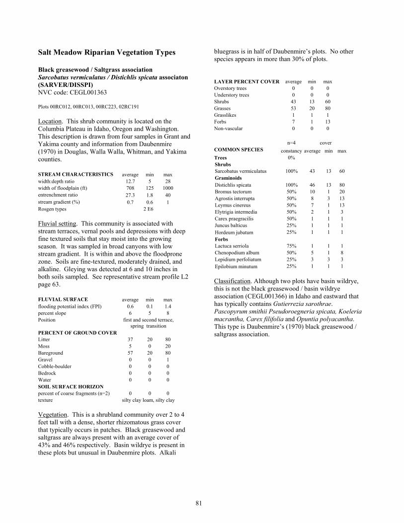
81
Salt Meadow Riparian Vegetation Types Black greasewood / Saltgrass association Sarcobatus vermiculatus / Distichlis spicata associaton (SARVER/DISSPI) NVC code: CEGL001363 Plots 00RC012, 00RC013, 00RC223, 02RC191 Location. This shrub community is located on the Columbia Plateau in Idaho, Oregon and Washington. This description is drawn from four samples in Grant and Yakima county and information from Daubenmire (1970) in Douglas, Walla Walla, Whitman, and Yakima counties. STREAM CHARACTERISTICS average min max width:depth ratio 12.7 5 28 width of floodplain (ft) 708 125 1000 entrenchment ratio 27.3 1.8 40 stream gradient (%) 0.7 0.6 1 Rosgen types 2 E6 Fluvial setting. This community is associated with stream terraces, vernal pools and depressions with deep fine textured soils that stay moist into the growing season. It was sampled in broad canyons with low stream gradient. It is within and above the floodprone zone. Soils are fine-textured, moderately drained, and alkaline. Gleying was detected at 6 and 10 inches in both soils sampled. See representative stream profile L2 page 63. FLUVIAL SURFACE average min max flooding potential index (FPI) 0.6 0.1 1.4 percent slope 6 5 8 Position first and second terrace,
spring transition PERCENT OF GROUND COVER Litter 37 20 80 Moss 5 0 20 Bareground 57 20 80 Gravel 0 0 1 Cobble-boulder 0 0 0 Bedrock 0 0 0 Water 0 0 0 SOIL SURFACE HORIZON percent of coarse fragments (n=2) 0 0 0 texture silty clay loam, silty clay Vegetation. This is a shrubland community over 2 to 4 feet tall with a dense, shorter rhizomatous grass cover that typically occurs in patches. Black greasewood and saltgrass are always present with an average cover of 43% and 46% respectively. Basin wildrye is present in these plots but unusual in Daubenmire plots. Alkali
bluegrass is in half of Daubenmire’s plots. No other species appears in more than 30% of plots. LAYER PERCENT COVER average min max Overstory trees 0 0 0 Understory trees 0 0 0 Shrubs 43 13 60 Grasses 53 20 80 Grasslikes 1 1 1 Forbs 7 1 13 Non-vascular 0 0 0 n=4 cover COMMON SPECIES constancy average min max Trees 0% Shrubs Sarcobatus vermiculatus 100% 43 13 60 Graminoids Distichlis spicata 100% 46 13 80 Bromus tectorum 50% 10 1 20 Agrostis interrupta 50% 8 3 13 Leymus cinereus 50% 7 1 13 Elytrigia intermedia 50% 2 1 3 Carex praegracilis 50% 1 1 1 Juncus balticus 25% 1 1 1 Hordeum jubatum 25% 1 1 1 Forbs Lactuca serriola 75% 1 1 1 Chenopodium album 50% 5 1 8 Lepidium perfoliatum 25% 3 3 3 Epilobium minutum 25% 1 1 1 Classification. Although two plots have basin wildrye, this is not the black greasewood / basin wildrye association (CEGL001366) in Idaho and eastward that has typically contains Gutierrezia sarothrae. Pascopyrum smithii Pseudoroegneria spicata, Koeleria macrantha, Carex filifolia and Opuntia polyacantha. This type is Daubenmire’s (1970) black greasewood / saltgrass association.

82
Saltgrass - Clustered field sedge community type Distichlis spicata - Carex praegracilis community type (DISSPI-CARPAR) NVC code: none Plots 98RC033, 98RC055, 98RC115, 98RC124, 98RC173, 98RC253, 00RC214, 00RC222 Location. This grassland was sampled along Cow Creek in Adams County and Crab Creek in Grant County and has been observed in adjacent counties. As described here, this community may occur on appropriate sites across the Columbia Plateau. STREAM CHARACTERISTICS average min max width:depth ratio 57.6 13.0 120 width of floodplain (ft) 491 56 1600 entrenchment ratio 1.9 1.3 3.3 stream gradient (%) 0.8 0.5 2 Rosgen types 2 C3, E1, 2 E6, 2 F1, F6 Fluvial setting. This community is associated with stream terraces, vernal pools, and depressions with deep fine textured soils that stay moist into the growing season. It was sampled in broad canyons with low stream gradients although it appears in other settings. This community was sampled on stream terraces usually within the floodprone zone and in a vernal basin. All but one sample was associated with a regulated perennial stream. Sites are generally convex and appear to flood in high water years. Soils are fine-textured, well drained, and alkaline. Mottling was detected at 13 and 36 inches and undetected in the top 30 inches of soil at one site. See representative stream profile L1 page 63. FLUVIAL SURFACE average min max flooding potential index (FPI) 0.6 -0.1 1.3 percent slope 1.2 0.0 5.0 position channel shelf, floodplain,
4 first terraces, second terrace, basin
PERCENT OF GROUND COVER Litter 43 5 95 Moss 7 0 40 Bareground 51 5 95 Gravel 0 0 0 Cobble-boulder 0 0 1 Bedrock 0 0 0 Water 0 0 0 SOIL SURFACE HORIZON
percent of coarse fragments (n=5) 0 0 0 texture 4 silt loam, silty clay
loam Vegetation. This is a dense grassland community less than a foot tall dominated by three rhizomatous grasses
and one rhizomatous sedge species. Saltgrass is always present with 30-90% cover. It always occurs with clustered field sedge having 1-40% cover. Alkali bluegrass is usually present and often is as abundant as saltgrass. Prairie cordgrass is usually present but rarely with high coverage. Intermediate wheatgrass was planted at two sites. No other species was found in more than three of the six plots sampled. This type appeared adjacent to the less alkaline/saline, more moist communities Baltic rush, woolly sedge, and clustered field sedge pasture with intermediate wheatgrass. Basin wildrye, black hawthorn or greasewood community are also typical adjacent community types. Management information applicable to this type is summarized in Hansen et al. (1995 page 431). LAYER PERCENT COVER average min max Overstory trees 0 0 0 Understory trees 0 0 0 Shrubs 0 0 0 Grasses 81 50 98 Grasslikes 27 1 98 Forbs 11 1 20 Non-vascular 0 0 0 n=8 cover COMMON SPECIES constancy average min max Trees 0% Shrubs 0% Graminoids Distichlis spicata 100% 56 30 98 Carex praegracilis 75% 18 1 40 Poa secunda (juncifolia) 63% 30 8 40 Spartina gracilis 50% 15 3 30 Juncus balticus 38% 15 1 40 Puccinellia lemmonii 13% 3 3 3 Schoenoplectus americanus 13% 1 1 1 Forbs Lactuca serriola 50% 1 1 1 Ranunculus cymbalaria 38% 2 1 3 Achillea millefolium 25% 5 1 8 Grindelia squarrosa 25% 2 1 3 Argentina anserina 25% 1 1 1 Potentilla argentea 25% 1 1 1 Classification. This type is similar to the saltgrass community that occurs in western United States (CEGL001770) but may represent a new type. Clustered field sedge is absent from Hansen et al. (1995) saltgrass association in Montana. Crowe and Clausnitzer (1997) and Titus et al. (1998) describe a clustered field sedge association that has no saltgrass and occurs on wetter, perhaps less saline sites. Clustered field sedge is co-dominant with Baltic rush in plot 00RC022 and may represent the clustered field sedge association (CEGL00182) of Evans (1989) and Jankovsky-Jones et al. (2001) in southeast Idaho.

83
Saltgrass - Chairmaker’s bulrush community type Distichlis spicata - Schoenoplectus americanus community type (DISSPI-SCHAME) NVC code: none Plots 00RC014, 00RC103, 00RC221 Location. This community is found in localized sites across the Columbia Plateau. This bulrush-grass community was sampled along lower Crab Creek in Grant County and Foster Creek in Douglas County. It is probable in other parts of the Columbia Basin. STREAM CHARACTERISTICS average min max width:depth ratio 16.5 5 28 width of floodplain (ft) 562.5 125 1000 entrenchment ratio 20.9 1.8 40 stream gradient (%) 0.9 0.6 1 Rosgen types 2 E6, spring
Fluvial setting. This community is associated with streamsides and depressions with fine textured soils that stay wet into the growing season. It was sampled in moderate to broad canyons with low stream gradients. This community was sampled at or near bankfull. Sites are generally sloping (shorelines) with soils that are fine-textured. Mottling and/or gleying were not detected in the top 18 inches of two sample sites. FLUVIAL SURFACE average min max flooding potential index (FPI) 0.2 0 0.4 percent slope 4.7 1 10 position abandon channel,
floodplain, first terrace PERCENT OF GROUND COVER Litter 83 65 95 Moss 0 0 0 Bareground 15 5 30 Gravel 2 0 5 Cobble-boulder 0 0 0 Bedrock 0 0 0 Water 0 0 0 SOIL SURFACE HORIZON
percent of coarse fragments (n=2) 0 0 0 texture fibric, silty clay loam Vegetation. This is a dense grassland community less than a foot tall dominated by a rhizomatous bulrush, grass and sedge. Chairmaker’s bulrush is always present with 20-80% cover. It always occurs with saltgrass and usually with clustered field sedge, Baltic rush, or silverweed cinquefoil. Alkali bluegrass or Lemmon’s alkaligrass can be abundant. Management information is not available for this type. Pertinent management information on key species appears in Table 3.
LAYER PERCENT COVER average min max Overstory trees 8 8 8 Understory trees 0 0 0 Shrubs 0 0 0 Grasses 40 40 40 Grasslikes 73 70 80 Forbs 30 20 40 Non-vascular 0 0 0 n=3 cover COMMON SPECIES constancy average min max Trees Elaeagnus angustifolia 33% 8 8 8 Shrubs 0% Graminoids Schoenoplectus americanus 100% 47 20 80 Distichlis spicata 100% 24 3 40 Carex praegracilis 67% 50 30 70 Juncus balticus 67% 27 3 50 Hordeum jubatum 67% 16 1 30 Puccinellia lemmonii 33% 30 30 30 Poa secunda (juncifolia) 33% 20 20 20 Hordeum brachyantherum 33% 8 8 8 Leymus cinereus 33% 3 3 3 Elytrigia repens var. repens 33% 3 3 3 Spartina gracilis 33% 3 3 3 Forbs Argentina anserina 67% 5 1 8 Chenopodium album 67% 3 3 3 Crepis runcinata 33% 40 40 40 Lactuca serriola 33% 30 30 30 Classification. Schoenoplectus americanus is synonomus with Scirpus americanus in Hitchock and Cronquist (1973). Hansen et al. (1995) recognized a Scirpus pungens association in Montana that included all combinations of S. pungens and S. americanus. This type was described by Crawford (2001) and was earlier recognized by Evans (1989) for eastern Washington. It may be included in the general western Chairmaker’s bulrush western herbaceous association (CEGL001841). That general type as described by Jankovsky-Jones et al. (2001) in southeast Idaho lacks saltgrass and other saline/alkine indicators. Titus et al. (1998) list a possible similar type: the Scripus americanus alkaline interior association.

84
Alkali cordgrass association Spartina gracilis association (SPAGRA) NVC code: CEGL001588 Plots 00RC062, 00RC215 Location. This dense grass community was sampled along lower Crab Creek in Adams and Grant counties. It is probable in other parts of the Columbia Basin. STREAM CHARACTERISTICS average min max width:depth ratio 11.7 8.3 15 width of floodplain (ft) 30 30 30 entrenchment ratio 1.5 1.5 1.5 stream gradient (%) 1.8 0.5 3 Rosgen types B1, E6 Fluvial setting. This community is associated with stream terraces and depressions with coarse textured soils that stay moist into the growing season. It was sampled in along streams with moderate to low gradients. This community was sampled above the floodprone zone. Sites are generally flat with soils that are coarse textured, well drained, and alkaline. A mottled soil layer was encountered at 8 inches at one site. FLUVIAL SURFACE average min max flooding potential index (FPI) 1.1 1.1 1.1 percent slope 5.3 0.5 10.0 Position first and second
terraces PERCENT OF GROUND COVER Litter 98 95 100 Moss 0 0 0 Bareground 2 0 5 Gravel 0 0 0 Cobble-boulder 0 0 0 Bedrock 0 0 0 Water 0 0 0 SOIL SURFACE HORIZON
percent of coarse fragments (n=1) 0 texture sand Vegetation. This is community is a closed grassland dominated by native rhizomatous species. Alkali cordgrass usually occurs with clustered field sedge. Nevada bulrush or Baltic rush can be abundant. Saltgrass is often present but with low cover. Forbs are mostly weedy species in the two samples. This type is similar to the saltgrass - clustered field sedge and the basin wildrye / clustered field sedge communities. Applicable management information is summarized in Hansen (1995 page 467). Pertinent management information on key species appears in Table 3.
LAYER PERCENT COVER average min max Overstory trees 0 0 0 Understory trees 3 3 3 Shrubs 0 0 0 Grasses 50 40 60 Grasslikes 50 40 60 Forbs 8 8 8 Non-vascular 0 0 0 n=2 cover COMMON SPECIES constancy average min max Trees Elaeagnus angustifolia 50% 3 3 3 Shrubs 0% Graminoids Spartina gracilis 100% 50 40 60 Carex praegracilis 100% 2 1 3 Scirpus nevadensis 50% 60 60 60 Juncus balticus 50% 40 40 40 Distichlis spicata 50% 8 8 8 Forbs Lactuca serriola 100% 5.5 3 8 Cirsium arvense 50% 3 3 3 Equisetum laevigatum 50% 3 3 3 Classification. This type is poorly described from literature in Colorado. Hansen’s (1995) Prairie cordgrass (Spartina pectinata) association includes combinations of prairie and alkali cordgrass. Prairie cordgrass association in Washington occurs only on riverside environments.

85
Basin wildrye-Saltgrass association Leymus cinereus - Distichlis spicata association (LEYCIN/DISSPI) NVC code: CEGL001481 Plots 98RC034, 98RC044, 98RC095 Location. This tall herbaceous community is located on the Columbia Plateau in Idaho, Oregon and Washington. This description is from samples from Cow Creek in Adams County and plots from Daubenmire (1970) in Douglas, Walla Walla, and Yakima counties. STREAM CHARACTERISTICS average min max width:depth ratio 54.7 14 120 width of floodplain (ft) 846.7 340 1600 entrenchment ratio 16.0 1.3 42.9 stream gradient (%) 0.5 0.5 0.5 Rosgen types C1, C6c, F1
Fluvial setting. This community is associated with stream terraces, vernal pools, and depressions with deep fine textured soils that stay moist into the growing season. On Cow Creek it was sampled in broad canyons with low stream gradients. It is within the floodprone zone. Soils are fine-textured, moderately drained, and alkaline. Mottling was detected at 28 inches at one site and undetected in the top 24 inches of another sample. FLUVIAL SURFACE average min max flooding potential index (FPI) 0.4 0.1 0.7 percent slope 2.0 0.5 5.0 Position floodplain, 2 first
terraces PERCENT OF GROUND COVER Litter 7 2 10 Moss 20 0 60 Bareground 69 20 98 Gravel 0 0 0 Cobble-boulder 0 0 0 Bedrock 0 0 0 Water 0 0 0 SOIL SURFACE HORIZON percent of coarse fragments (n=2) 0 0 0 texture 2 silt loam Vegetation. This community is composed of a tall bunchgrass usually over 4 feet tall scattered over a dense, shorter rhizomatous grass cover. Basin wildrye and saltgrass are always present with an average cover 30% and 50% respectively. Clustered field sedge averages 16% cover. Alkali bluegrass and prairie cordgrass are present in these plots but unusual in Daubenmire plots, whereas, cheatgrass occurred only in Daubenmire plots. Western yarrow was found in most plots. No other
species appears in more than 30% of plots. This is a low diversity community with 5 to 17 species per plot. Management information applicable to this type is summarized in Hansen et al. (1995 page 431). LAYER PERCENT COVER average min max Overstory trees 0 0 0 Understory trees 0 0 0 Shrubs 0 0 0 Grasses 77 60 90 Grasslikes 8 3 13 Forbs 1 1 1 Non-vascular 0 0 0 n=3 cover COMMON SPECIES constancy average min max Trees 0% Shrubs 0% Graminoids Poa secunda (juncifolia) 100% 51 13 80 Distichlis spicata 100% 10 3 13 Carex praegracilis 100% 8 3 13 Leymus cinereus 100% 8 3 13 Spartina gracilis 100% 6 3 8 Poa secunda 33% 40 40 40 Forbs Achillea millefolium 67% 1 1 1 Cirsium vulgare 67% 1 1 1 Classification. This type is Daubenmire’s (1970) basin wildrye / saltgrass association.

86
Basin wildrye - clustered field sedge association Leymus cinereus - Carex praegracilis association (LEYCIN-CARPRA) NVC code: CEGL0001480 Plots 98RC084, 98RC163, 98RC252, 99RC144, 99RC202, 00RC124 Location. This grassland was sampled along Cow Creek in Adams County, along Lake and Sinking Creeks in Lincoln County and along Foster Creek in Douglas County. It occurs on appropriate sites across the Columbia Plateau. STREAM CHARACTERISTICS average min max width:depth ratio 28.8 2.5 120 width of floodplain (ft) 290 18 1500 entrenchment ratio 12.4 1.3 53.6 stream gradient (%) 1 0 2 Rosgen types C3, C4, C6, 2 E6, F6 Fluvial setting. This community is associated with broad stream terraces or depressions with deep fine textured soils that stay wet into the growing season. It was sampled in 100 foot and wider canyons with less than 3% gradient. This community was sampled at and above the floodprone zone and was observed along the margins of wide vernal basins. One site is within the floodprone zone. Sites are generally flat with soils that are fine-textured loamy and well drained. Gleying was detected at 40 inches at one sample and was undetected in the top 36 inches of two samples. See representative stream profile S1 page 36and L2 page 63. FLUVIAL SURFACE average min max flooding potential index (FPI) 1.3 0.5 2.3 percent slope 5.2 0 25 Position floodplain, first
terrace, 2 second terraces, toeslope,
basin PERCENT OF GROUND COVER Litter 89 80 95 Moss 1 0 5 Bareground 9 5 20 Gravel 0 0 0 Cobble-boulder 0 0 0 Bedrock 0 0 0 Water 0 0 0 SOIL SURFACE HORIZON
percent of coarse fragments (n=2) 0 0 0 texture loam, 2 silt loam Vegetation. This is an open 5 to 8-foot tall bunchgrass community with a shorter, less than 2-foot tall, closed grassland ground cover dominated by rhizomatous grasses and sedges. Basin wildrye is always present and
often abundant with 40-60% cover. On disturbed sites its cover can be greatly reduced in favor of quackgrass. Clustered field sedge is always present with 30 to 40% cover. Kentucky bluegrass, prairie cordgrass and Baltic rush are common and may be abundant. Saltgrass can be a common species but subordinate to clustered field sedge. Clasping pepperweed, Rocky Mountain iris, and Canadian thistle are the most frequent forbs in samples. This type appeared adjacent to the less alkaline/saline more moist reed canarygrass and quaking aspen communities and saltgrass or greasewood communities. Management information is not available for this type. Pertinent management information on key species appears in Table 3. LAYER PERCENT COVER average min max Overstory trees 0 0 0 Understory trees 0 0 0 Shrubs 2 1 3 Grasses 62 50 80 Grasslikes 37 1 60 Forbs 20 3 40 Non-vascular 0 0 0 n=6 cover COMMON SPECIES constancy average min max Trees 0% Shrubs Symphoricarpos albus 17% 3 3 3 Rosa woodsii 17% 1 1 1 Graminoids Carex praegracilis 100% 35 1 60 Leymus cinereus 100% 32 1 60 Poa pratensis 83% 20 3 50 Distichlis spicata 67% 9 1 30 Spartina gracilis 67% 9 1 20 Juncus balticus 50% 10 8 13 Elytrigia repens var. repens 33% 26 13 40 Poa secunda (juncifolia) 33% 7 1 13 Agrostis interrupta 17% 13 13 13 Forbs Lepidium perfoliatum 83% 3 1 8 Cirsium arvense 67% 7 1 20 Lactuca serriola 67% 6 1 20 Potentilla argentea 33% 8 3 13 Classification. Daubenmire’s (1970) basin wildrye / saltgrass association (CEGL001481) is similar to this type but contains more alkali bluegrass, an abundance of saltgrass, has less clustered field sedge, and no Kentucky bluegrass. The basin wildrye / saltgrass association is generally less diverse and is probably associated with more saline or alkaline soil. This type is similar to the basin wildrye bottomland community that occurs in western U.S.

87
Basin wildrye - cheatgrass community type Leymus cinereus - Bromus tectorum community type (LEYCIN/BROTEC) NVC code: none Plots 98RC024, 98RC184, 98RC233, 99RC064, 02RC103 Location. This community was sampled in Lincoln and Adams counties and is likely to occur on appropriate sites across the Columbia Plateau. STREAM CHARACTERISTICS average min max width:depth ratio 16.9 5 30 width of floodplain (ft) 154.6 10 500 entrenchment ratio 7.8 1.7 26.3 stream gradient (%) 1.7 1.5 2 Rosgen types B3c, C3, E4, E5, E6 Fluvial setting. This type is associated with a variety of drier fluvial landforms and upland sites. Valley gradient is less than 3%. It was sampled well above and just below the floodprone zone. Sites were flat to rolling with fine-textured and well-drained soil. See representative stream profile T3 page 23, L4 page 63, and G2 page 73. FLUVIAL SURFACE average min max flooding potential index (FPI) 4.3 0.7 11.5 percent slope 5.3 0 15 position 2 intermittent channels,
2 first terrace, toeslope PERCENT OF GROUND COVER Litter 87 70 100 Moss 0 0 0 Bareground 9 0 30 Gravel 0 0 0 Cobble-boulder 2 0 10 Bedrock 0 0 0 Water 0 0 0 SOIL SURFACE HORIZON
percent of coarse fragments (n=3 ) 3 0 10 texture 3 silt loam Vegetation. This grassland is often seen with a scattered tall basin wildrye layer (over 5 feet tall) over an annual and forb grass layer. Cheatgrass is the common link in these weedy sites. Other weeds that often are abundant include medusa head, Japanese brome, leporinum barley, prickly lettuce, tall tumble mustard, and giant sumpweed. This community appeared adjacent to more moist reed canarygrass or quackgrass communities and boxelder or upland communities. Similar communities are found outside the riparian zone. This is a retrogressed community probably on several different potential vegetation sites. Management information is not available to this type.
LAYER PERCENT COVER average min max Overstory trees 0 0 0 Understory trees 1 1 1 Shrubs 16 3 30 Grasses 70 40 90 Grasslikes 1 1 1 Forbs 53 40 70 Non-vascular 0 0 0 n=5 cover COMMON SPECIES constancy average min max Trees Alnus incana 20% 1 1 1 Shrubs Chrysothamnus viscidiflorus 20% 30 30 30 Artemisia tridentata ssp. tridentata 20% 13 13 13 Graminoids Leymus cinereus 100% 38 20 90 Bromus tectorum 100% 28 1 60 Poa secunda 40% 5 3 8 Bromus japonicus 20% 20 20 20 Forbs Lepidium perfoliatum 40% 11 3 20 Sisymbrium altissimum 40% 3 3 3 Amsinckia menziesii 20% 60 60 60 Iva xanthifolia 20% 40 40 40 Conium maculatum 20% 30 30 30 Claytonia perfoliata ssp. perfoliata 20% 20 20 20 Polemonium pectinatum 20% 20 20 20 Descurainia pinnata 20% 13 13 13 Descurainia sophia 20% 13 13 13 Chenopodium album 20% 8 8 8 Collinsia linearis 20% 8 8 8 Classification. Crawford (1998, 2001) described this type. It is a common vegetation type throughout the inland Pacific Northwest and classified as a provisional type CEGL001479.
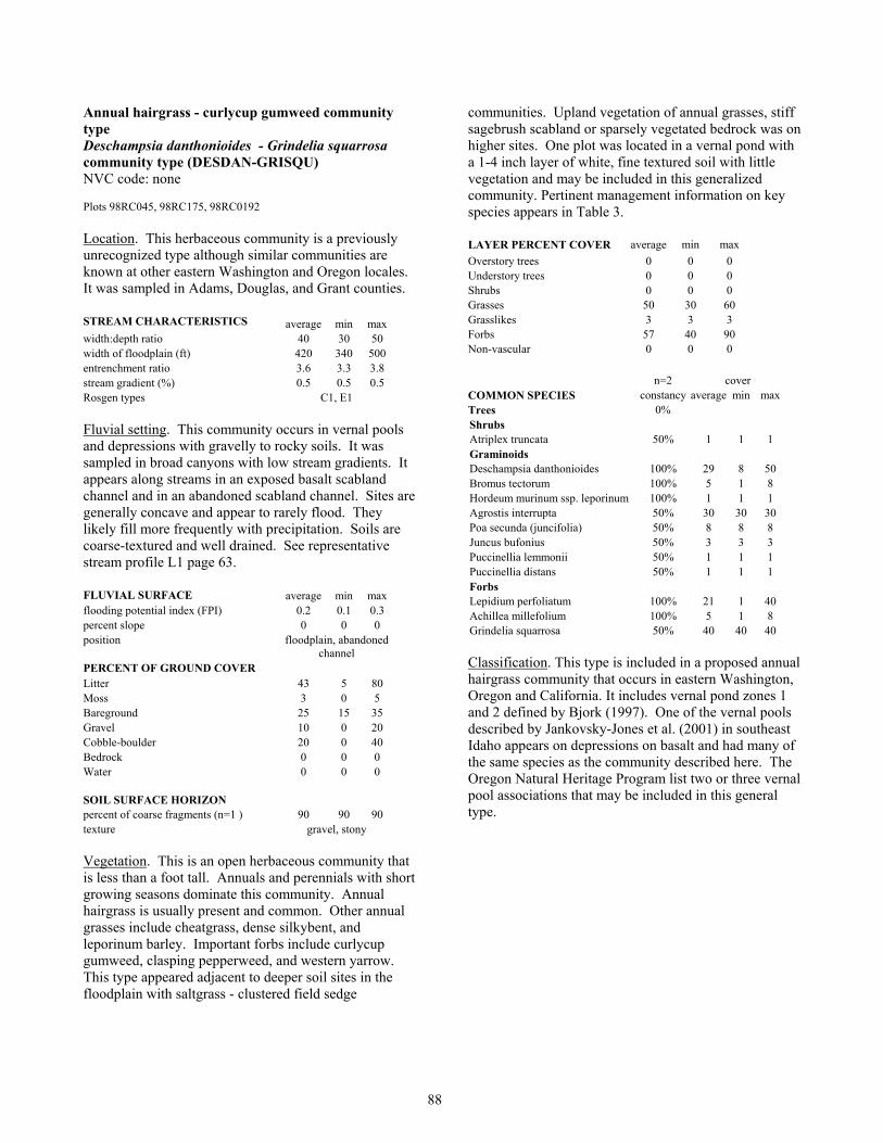
88
Annual hairgrass - curlycup gumweed community type Deschampsia danthonioides - Grindelia squarrosa community type (DESDAN-GRISQU) NVC code: none Plots 98RC045, 98RC175, 98RC0192 Location. This herbaceous community is a previously unrecognized type although similar communities are known at other eastern Washington and Oregon locales. It was sampled in Adams, Douglas, and Grant counties. STREAM CHARACTERISTICS average min max width:depth ratio 40 30 50 width of floodplain (ft) 420 340 500 entrenchment ratio 3.6 3.3 3.8 stream gradient (%) 0.5 0.5 0.5 Rosgen types C1, E1 Fluvial setting. This community occurs in vernal pools and depressions with gravelly to rocky soils. It was sampled in broad canyons with low stream gradients. It appears along streams in an exposed basalt scabland channel and in an abandoned scabland channel. Sites are generally concave and appear to rarely flood. They likely fill more frequently with precipitation. Soils are coarse-textured and well drained. See representative stream profile L1 page 63. FLUVIAL SURFACE average min max flooding potential index (FPI) 0.2 0.1 0.3 percent slope 0 0 0 position floodplain, abandoned
channel PERCENT OF GROUND COVER Litter 43 5 80 Moss 3 0 5 Bareground 25 15 35 Gravel 10 0 20 Cobble-boulder 20 0 40 Bedrock 0 0 0 Water 0 0 0 SOIL SURFACE HORIZON
percent of coarse fragments (n=1 ) 90 90 90 texture gravel, stony Vegetation. This is an open herbaceous community that is less than a foot tall. Annuals and perennials with short growing seasons dominate this community. Annual hairgrass is usually present and common. Other annual grasses include cheatgrass, dense silkybent, and leporinum barley. Important forbs include curlycup gumweed, clasping pepperweed, and western yarrow. This type appeared adjacent to deeper soil sites in the floodplain with saltgrass - clustered field sedge
communities. Upland vegetation of annual grasses, stiff sagebrush scabland or sparsely vegetated bedrock was on higher sites. One plot was located in a vernal pond with a 1-4 inch layer of white, fine textured soil with little vegetation and may be included in this generalized community. Pertinent management information on key species appears in Table 3. LAYER PERCENT COVER average min max Overstory trees 0 0 0 Understory trees 0 0 0 Shrubs 0 0 0 Grasses 50 30 60 Grasslikes 3 3 3 Forbs 57 40 90 Non-vascular 0 0 0 n=2 cover COMMON SPECIES constancy average min max Trees 0% Shrubs Atriplex truncata 50% 1 1 1 Graminoids Deschampsia danthonioides 100% 29 8 50 Bromus tectorum 100% 5 1 8 Hordeum murinum ssp. leporinum 100% 1 1 1 Agrostis interrupta 50% 30 30 30 Poa secunda (juncifolia) 50% 8 8 8 Juncus bufonius 50% 3 3 3 Puccinellia lemmonii 50% 1 1 1 Puccinellia distans 50% 1 1 1 Forbs Lepidium perfoliatum 100% 21 1 40 Achillea millefolium 100% 5 1 8 Grindelia squarrosa 50% 40 40 40 Classification. This type is included in a proposed annual hairgrass community that occurs in eastern Washington, Oregon and California. It includes vernal pond zones 1 and 2 defined by Bjork (1997). One of the vernal pools described by Jankovsky-Jones et al. (2001) in southeast Idaho appears on depressions on basalt and had many of the same species as the community described here. The Oregon Natural Heritage Program list two or three vernal pool associations that may be included in this general type.

89
Bluebunch wheatgrass community type Pseudoroegneria spicata community type (PSESPI) NVC code: none Plots 99RC20, 00RC082, 00RC093 Location. This herbaceous community is a previously unrecognized riparian type although similar communities are known in Washington and Oregon. Samples are from Douglas, Grant, and Lincoln counties. STREAM CHARACTERISTICS average min max width:depth ratio 10.8 6 14 width of floodplain (ft) 7 2 13 entrenchment ratio 1.3 1.3 1.3 stream gradient (%) 5.3 1 8 Rosgen types 3 A3 Fluvial setting. This community occurs near ephemeral and intermittent streams in moderate to narrow valleys. Streams have moderate to steep gradients. Sites are well above the floodprone zone unless where associated with ephemeral streams when appears in the floodprone zone. In either case, sites rarely flood. Soils are coarse-textured and well drained. See representative stream profile S7 page 36. FLUVIAL SURFACE average min max flooding potential index (FPI) 1.8 -0.4 3.4 percent slope 5.5 5 6 position floodplain, first terrace,
streambank PERCENT OF GROUND COVER
Litter 48 30 65 Moss 13 5 20 Bareground 13 5 20 Gravel 16 12 20 Cobble-boulder 17 8 25 Bedrock 0 0 0 Water 0 0 0 SOIL SURFACE HORIZON
percent of coarse fragments (n=2 ) 0 0 0 texture cobble, sandy loam Vegetation. This is an open herbaceous community that is around two feet tall and dominated by annual and perennial herbaceous plants. Shrubs are usually present as scattered individuals. Both Wyoming and Basin big sagebrush occur in this community. Bluebunch wheatgrass and Sandberg’s bluegrass are always present although cheatgrass will have greater cover in many instances. Western yarrow is the most frequent forb species. Pertinent management information on key species appears in Table 3.
LAYER PERCENT COVER average min max Overstory trees 0 0 0 Understory trees 0 0 0 Shrubs 13 1 30 Grasses 27 20 40 Grasslikes 0 0 0 Forbs 14 10 20 Non-vascular 5 5 5 n=3 cover COMMON SPECIES constancy average min max Trees 0% Shrubs Artemisia tridentata ssp. tridentata 33% 30 30 30 Ericameria nauseosa ssp. nauseosa 33% 8 8 8 Artemisia tridentata ssp. wyomingensis 33% 3 3 3 Graminoids Bromus tectorum 100% 13 8 20 Poa secunda 100% 8 1 20 Pseudoroegneria spicata 100% 6 3 13 Elymus lanceolatus 33% 30 30 30 Vulpia spp 33% 10 10 10 Forbs Achillea millefolium 67% 1 1 1 Equisetum laevigatum 33% 20 20 20 Epilobium minutum 33% 8 8 8 Pteryxia terebinthina var. terebinthina 33% 8 8 8 Artemisia biennis 33% 3 3 3 Moss and Lichen 33% 5 5 5 Classification. This is a previously undescribed riparian type. It is similar to upland big sagebrush communities and is usually included within the variation of those types.

90
Forb Riparian Vegetation Types Plot locations
Selected stream profiles F1
Stream and riparian vegetation profile at Coal Creek, Lincoln County. 1= reed canarygrass, 2= common horsetail, 3= woolly sedge – common spikerush and 4= Nebraska sedge - silverweed cinquefoil, 5= Baltic rush, and 6= basin wildrye - cheatgrass.
F2
Stream and riparian vegetation profile at Green Creek, Asotin County. 0 =watercress, 1=black hawthorn / common snowberry, and 2 = bunchgrass uplands.

91
Forb Riparian Types Common Horsetail community type Equisetum arvense community type (EQUARV) NVC code: none Plots 99CB100, 99CB501 99CB502, 99CB701, 99CB702, 99CB704, 99RC112, 00RC191, 02RC092, 02RC132 Location. This herbaceous community type is similar to a type described in Oregon. Sample locations are in Aostin, Columbia, Douglas, Lincoln, and Whitman counties. STREAM CHARACTERISTICS average min max width:depth ratio 12.5 4.5 36.7 width of floodplain (ft) 24.8 9 68 entrenchment ratio 1.9 1.2 2.6 stream gradient (%) 2.5 0.5 5 Rosgen types A3, B1, 2 B6, C5, E3, F6 Fluvial setting. This community appears in valleys with 1-3% gradients and 30 to 1000 feet wide. Surface slopes varied from 1 to 56%. Communities appear on various positions near bankfull to well above bankfull. Surface soil layer are 5 to 14 inches thick and have fine sandy loam to silty clay loam texture. Subsurface layers vary from gravel to buried histic soils. The higher terraces are sub-irrigated from adjacent slopes. Most of these sites have evidence of scouring flood events. See representative stream profiles F1 page 90 and S5 page 36. FLUVIAL SURFACE average min max flooding potential index (FPI) 1.7 -0.6 7.5 percent slope 18.2 1 56 Position 2 floodplain, abandon
channel, 2 channel shelves, 2 first terraces, streambank
PERCENT OF GROUND COVER Litter 67 0 99 Moss 1 0 10 Bareground 16 1 50 Gravel 4 0 20 Cobble-boulder 5 0 40 Bedrock 0 0 3 Water 7 0 70 SOIL SURFACE HORIZON
percent of coarse fragments (n=4) 22 1 60 texture Silt loam, fine sandy loam,
sandy clay loam, silty clay loam
Vegetation. Common horsetail dominates or co-dominates all plots with 30-80% cover. Baltic rush is co-dominant on some of those sites. Kentucky bluegrass is the most consistent companion and sometimes occurs abundantly. Other species that dominated individual plots were smooth brome, common spikerush, and small-fruited bulrush.
Several tree and shrub species occur in this community and usually represent remnants of previous vegetation. LAYER PERCENT COVER average min max Overstory trees 0 0 0 Understory trees 6 1 10 Shrubs 4 1 13 Grasses 16 1 60 Grasslikes 37 1 90 Forbs 65 30 100 Non-vascular 1 1 1 n=10 cover COMMON SPECIES constancy average min max Trees Salix alba 10% 10 10 10 Populus balsamorhiza ssp. trichocarpa 10% 8 8 8 Salix amygdaloides 10% 5 5 5 Acer negundo 10% 1 1 1 Betula occidentalis 10% 1 1 1 Crataegus douglasii 10% 1 1 1 Shrubs Philadelphus lewisii 20% 5 1 10 Salix exigua 20% 5 1 10 Artemisia ludoviciana 20% 4 1 8 Graminoids Poa pratensis 70% 11 3 30 Juncus balticus 50% 33 1 90 Eleocharis palustris 40% 16 1 50 Scirpus microcarpus 30% 14 1 40 Forbs Equisetum arvense 100% 56 30 90 Amsinckia lycopsoides 50% 1 1 1 Moss and Lichen 20% 1 1 1 Classification. This may represent the common horsetail type described by Titus et al. (1998, 6 plots) or by Crowe and Clausnitzer (1997, 5 plots). The wide range of co-dominant species and environments indicate that this is either an early seral community with a wide natural range of variation or a cover type containing several yet described community types. Further sampling may indicate splitting this broad type into different community types. Several plots have affinities with this common horsetail type although dominated by different tree species: Yellow willow / common horsetail (Salix lutea / Equisetum arvense) community, plot 00RC201, black cottonwood/ common horsetail, plot 02RC131, and described types: white alder/ common horsetail, water birch / common horsetail, and peachleaf willow/ common horsetail community types. All are on a scoured reaches on which the woody component is likely a legacy of a previous community/fluvial environment.

92
Gray’s biscuitroot community type Lomatium grayi community type (LOMGRA) NVC code: none Plots 02RC022, 02RC143, 02RC0150 Location. This herbaceous community is a previously unrecognized type although similar communities are known at other eastern Washington and Oregon locales. It was sampled in Klickitat, Grant and Whitman counties. STREAM CHARACTERISTICS average min max width:depth ratio 69.6 18 166.7 width of floodplain (ft) 67 60 76 entrenchment ratio 2.3 1.3 3.3 stream gradient (%) 1.8 1 3 Rosgen types 2 B3, E6 Fluvial setting. This community occurs in ephemeral and intermittent streambeds and abandon channels with gravelly to cobbly channels. It was sampled in broad canyons with low stream gradients. Sites are generally concave and appear to occasionally flood appear to scour the channel when they do flood. FLUVIAL SURFACE average min max flooding potential index (FPI) 0.6 -0.5 2.0 percent slope 4.3 1 10 Position Channel, abandoned
channel, first terrace PERCENT OF GROUND COVER Litter 16 10 25 Moss 3 0 8 Bareground 15 1 25 Gravel 58 35 90 Cobble-boulder 9 1 20 Bedrock 0 0 0 Water 0 0 0 SOIL SURFACE HORIZON
percent of coarse fragments (n=1 ) 73 70 80 texture Sandy loam, sandy clay
loam Vegetation. This is an open herbaceous community that is less than a foot tall. Annuals and perennials with short growing seasons dominate this community. Gray’s biscuitroot is usually present and common although other biscuitroot species (L. columbianum, L. dissectum) have been observed to dominate similar fluvial surfaces elsewhere in eastern Washington. Sprouting shrubs and vines, white sagebrush and white clematis, are frequently present with less than 5% cover. Grasses, usually bulbous bluegrass, Sandberg’s bluegrass and cheatgrass, typically display low cover although patches of rhizomatous grass (quackgrass) occur in areas with more fine textured soil. Important forbs include curlycup gumweed, field bindweed, and lambsquarters. This type appeared adjacent to deeper soil sites in the floodplain with Wyoming or
basin big sagebrush communities. LAYER PERCENT COVER average min max Overstory trees 0 0 0 Understory trees 0 0 0 Shrubs 2 1 3 Grasses 11 3 20 Grasslikes 0 0 0 Forbs 47 20 70 Non-vascular 10 10 10 n=3 cover COMMON SPECIES constancy average min max Trees 0% Shrubs Artemisia ludoviciana 67% 2 1 3 Clematis ligusticifolia 67% 1 1 1 Graminoids Poa bulbosa 100% 2 1 5 Poa secunda 67% 2 2 3 Bromus tectorum 67% 1 1 1 Elytrigia repens var. repens 33% 20 20 20 Agropyron cristatum 33% 1 1 1 Bromus japonicus 33% 1 1 1 Pseudoroegneria spicata 33% 1 1 1 Forbs Lomatium grayi 100% 46.67 20 70 Convolvulus arvensis 33% 8 8 8 Chenopodium album 33% 3 3 3 Grindelia squarrosa 33% 3 3 3 Moss and Lichen 33% 10 10 10 Classification. This type is a previously unrecognized community. It has environmental characteristics and floristic similarities with the white sagebrush associations, particularly those in ephemeral channels.

93
Watercress community type Rorippa nasturtium-aquaticum community type (RORNAS) NVC code: none Plots 98RC200, 99CB1300, 99CB1600, 99CB1800, 99CB2000, 99CB2100, 99RC180, 00RC130, 00RC200, 02RC010, 02RC071, 02RC080, 02RC201 Location. This community type is found throughout the western United States. In Washington, it has been sampled in Adams, Asotin, Douglas, Garfield, Grant, Klickitat, and Lincoln counties. STREAM CHARACTERISTICS average min max width:depth ratio 16.5 7.2 33.3 width of floodplain (ft) 25.3 5.7 68 entrenchment ratio 2.7 1.2 12 stream gradient (%) 4.6 0.5 13 Rosgen types A1, 2 A3a, A4, 2 B3, 2 B4,
C2, C3, F3b, F4, spring Fluvial setting. This community typically occurred with moderate to low stream gradients and relatively narrow stream widths. This community occurred along spring-fed channels and at a spring source. It appears at and below the floodprone zone on sites that are perennially flooded. At time of sampling, most of the sites were under slow moving water. Any exposed surface was either rock or gravel. Most soils are organic and shallow although a gleyed horizon appeared 16 inches below a mucky, organic surface layer at one sample site. See representative stream profile S4 page 36. FLUVIAL SURFACE average min max flooding potential index (FPI) -0.7 -1.3 0.0 percent slope 4.5 0.5 13 Position 11 channel shelves, 2
spring channels
PERCENT OF GROUND COVER Litter 24 0 90 Moss 3 0 15 Bareground 1 0 10 Gravel 8 0 40 Cobble-boulder 18 0 50 Bedrock 1 0 10 Water 45 5 94 SOIL SURFACE HORIZON percent of coarse fragments (n=3) 0 0 0 texture hemic, sapric, sandy clay
loam Vegetation. This is a dense herbaceous community dominated by annual aquatic species that typically is less than 6 inches tall. It may be underneath overhanging shrubs or tall marsh plants growing on adjacent, higher fluvial surfaces. Watercress is dominant in all sites and was always associated with either seep monkeyflower or
water speedwell or both. Species from adjacent less wet surfaces are present and varied by sites. This community occurred in the channel adjacent to white alder / Lewis’ mockorange, black hawthorn, snowberry, serviceberry / western poison ivy community and Nebraska sedge communities. LAYER PERCENT COVER average min max
Overstory trees 0 0 0 Understory trees 1 1 1 Shrubs 1 1 1 Grasses 8 1 40 Grasslikes 6 1 20 Forbs 54 1 100 Non-vascular 12 1 30 COMMON SPECIES n=13 cover constancy average min max Trees Salix amygdaloides 8% 1 1 1 Shrubs Salix lutea 8% 1 1 1 Graminoids Agrostis stolonifera 38% 9 1 40 Polypogon monspeliensis 23% 2 1 3 Eleocharis palustris 15% 2 1 3 Glyceria striata 15% 3 3 3 Juncus balticus 15% 7 1 13 Phalaris arundinacea 8% 13 13 13 Forbs Rorippa nasturtium-aquaticum 92% 44 1 100 Veronica anagallis-aquatica 85% 4 1 20 Mimulus guttatus 69% 7 1 40 Urtica dioica 38% 1 1 3 Moss and Lichen 23% 12 1 30 Classification. Evans (1989) noted that was relatively common on slow moving streams and springs in central Washington. The Oregon Natural Heritage Program (1998) listed one plot for this association.

94
Broadleaf cattail association Typha latifolia association (TYPLAT) NVC code: CEGL002010 Plots 99RC211, 99CB503, 00RC211, 02RC130 Location. This herbaceous community is found throughout the United States. It has been observed in Adams, Lincoln, Grant, Benton and Yakima counties in the Columbia Basi and is described in the mountains of eastern Washington. Samples are from Lincoln, Columbia, Grant and Whitman counties. STREAM CHARACTERISTICS average min max width:depth ratio 36.6 8.3 93.8 width of floodplain (ft) 514 15 1500 entrenchment ratio 12.4 1.1 53.6 stream gradient (%) 0.9 0.0 3 Rosgen types B1, C6, 2 E6, 2 F1,F3 Fluvial setting. This community is associated with river and lake shorelines prone to yearly flooding and with soils that often stay flooded throughout the growing season. It was sampled in valleys over 300 feet wide with 1% or less gradients. It occurs at or below bankfull. This community was sampled on streambanks and muddy point bars associated with slow-moving perennial streams and reservoirs, ponds or lakes. Soils typically have high organic content in surface layers and are associated with trapped fine-textured mineral particles. All sites were flooded at the time of sampling. FLUVIAL SURFACE average min max flooding potential index (FPI) 0.1 -0.3 0.8 percent slope 0.9 0 3 position 2 channel shelves,
floodplain, gravelbar, 2 streambanks, lake edge
PERCENT OF GROUND COVER Litter 33 5 59 Moss 0 0 0 Bareground 17 0 40 Gravel 0 0 1 Cobble-boulder 0 0 0 Bedrock 0 0 0 Water 50 0 80 SOIL SURFACE HORIZON
percent of coarse fragments (n=3) 0 0 0 texture 2 hemic, silt loam Vegetation. This is a dense herbaceous community dominated by 10-foot tall hard-stem bulrush, an aggressive rhizomatous species. Hard-stem bulrush can be the only species present. Broadleaf cattail is a common associate and forms a transition to pure cattail-dominated communities. It is adjacent to the channel and wet meadow or salt meadow communities. Management information applicable to this type is
summarized in Hansen et al. (1995 page 448) merged with soft-stem bulrush communities. LAYER PERCENT COVER average min max Overstory trees 0 0 0 Understory trees 1 1 1 Shrubs 1 1 1 Grasses 11 3 20 Grasslikes 18 1 30 Forbs 77 30 100 Non-vascular 0 0 0 n=4 cover COMMON SPECIES constancy average min max Trees Salix alba 25% 1 1 1 Shrubs Salix exigua 25% 1 1 1 Graminoids Schoenoplectus acutus 50% 22 13 30 Phalaris arundinacea 50% 12 3 20 Scirpus microcarpus 50% 2 1 3 Juncus balticus 25% 30 30 30 Carex utriculata 0% Glyceria striata 0% Forbs Typha latifolia 100% 68 20 90 Equisetum arvense 50% 9 3 15 Rorippa nasturtium-aquaticum 25% 50 50 50 Lemna minor 25% 13 13 13 Polygonum hydropiper 25% 8 8 8 Classification. This is the same association as described by Jankovsky-Jones et al. (2001) in southeast Idaho. This community has been merged with hard and/or soft-stem bulrush communities (Crawford 2001). A narrowleaf cattail community (plot 00RC031) found along a “tidal” environment created by flucuations along a reservoir edge maybe a distinct type from broadleaf cattail association.

95
Other Forb Riparian Types Broadfruit burreed community Sparganium eurycarpum plot (SPAEUR) Plot 98RC231 This herbaceous vegetation has been observed in Adams and Lincoln counties although not sampled in the latter. It also is recognized in Oregon and western Washington. This 5-foot tall herbaceous community was sampled on a channel shelf 6 inches below bankfull on B3c Rosgen stream type. This community is associated with sites prone to yearly flooding and with soils that can stay flooded throughout the growing season. It was sampled in a narrow canyon with low stream gradient. Soil was high in organic content in the surface layer and associated with fine-textured mineral soil. This is a dense herbaceous community is dominated by a rhizomatous species that looks superficially like broadleaf cattail. Broadleaf burreed dominated the sample and occurred with common spikerush. This site appeared along the channel and reed canarygrass communities. This type is undescribed from east of the Cascades. A similar cover type has been described from western Washington. Evans (1989) notes that this community is common in Lincoln County. Pertinent management information on key species appears in Table 2. Perennial pepperweed Lepidium latifolium community (LEPLAT) NVC code: none Plots 00RC011, 00RC021 Perennial pepperweed is an exotic plant (Class B Weed, Wa. Department of Agriculture) that appears to be creating a new community type. This herbaceous vegetation has been observed in Grant and Yakima counties and is likely in surrounding counties. This 4 to 6-foot tall herbaceous community was sampled along the wet fringe of lower Crab Creek. This community is associated with sites prone to yearly flooding and with soils that can stay flooded throughout the growing season. It was sampled in a broad canyon with low stream gradient. Soil surface layers and associated with fine-textured mineral soil. The stream is a Rosgen E6 stream type that is part of a regulated hydrologic system dominated by irrigation. The soil surface is completely obscured by litter. This is a dense herbaceous community dominated by an aggressively invasive, rhizomatous species. Most of the associated species are wet site species that are tolerant of disturbance, such as, Baltic rush, Canada thistle, Fuller's teasel, and stinging nettle. Both broadleaf cattail and hardstem bulrush are present.
Aquatic Forb Riparian Types Whitewater crowfoot community Ranunculus aquatilis plot (RANAQU) NVC code: none Plot 98RC0042 This submerged vegetation has been observed in aquatic beds across Washington and Oregon. It was sampled in the channel of a C1 Rosgen stream type and associated with perennially flooded channels with a rocky, cobbly bottom. It was in a broad canyon with low stream gradient. This is often a dense herbaceous community dominated by a perennial aquatic plants. The only other common vascular species were common duckweed, arumleaf arrowhead, and pondweed species. Algae, Moss and Lichen, and freshwater sponges have been observed with this community. The sample site occurs in the channel adjacent to a woolly sedge community. This type is undescribed although it may resemble the Ranunculus aquatilis - Callitriche palustris herbaceous vegetation (CEGL001984) described in Colorado. A similar communityt this one is recognized by Titus et al. 1998. Canadian waterweed community Eleodea canadensis plot (ELECAN) NVC code: none Plot 99CB400 This submerged vegetation has been observed in aquatic beds across Washington and Oregon. It was sampled in the channel of a F3 Rosgen stream type and associated with perennially flooded channels with a rocky, cobbly bottom. It was in a broad canyon with low stream gradient. This is often a dense herbaceous community dominated by a perennial aquatic plants. Algae, and Moss and Lichen were observed in this community. The sample site occurs in the channel adjacent to the exotic dominated indigobush community. A similar communityt this one is recognized by Titus et al. 1998.

96
Columbia Basin Riparian Associations not sampled Several reports from different parts of the Columbia Basin in Washington have listed riparian vegetation types, most of which have affinities to or are the equivalent to the those described in this report. The following is a list of types recognized by other authors but not discussed in this report. Each type appears with its expected environmental distribution in the Washington and the author of the type.
NVC code Community type Habitat Source plot # Tree- dominated CEGL000668 Populus balsamifera ssp. trichocarpa - Alnus rhombifolia Forest river
terrace Daubenmire 1970
0 Evans 1989 2 CEGL000667 Populus balsamifera ssp. trichocarpa / Alnus incana Forest river
terrace Kovalchik 1992 10
CEGL000671 Populus balsamifera ssp. trichocarpa / Cicuta douglasii Forest river terrace
Daubenmire 1970 0
none Populus balsamifera ssp. trichocarpa / Equisetum hymenale Forest
floodplain Salstrom & Easterly 1995
1
CEGL000577 Populus tremuloides / Carex pellita Forest springs Kovalchik 1992 3
CEGL001081 Betula occidentalis / Crataegus douglasii Shrubland river terrace
Evans 1989 1
CEGL000948 Salix amygdaloides / Salix exigua Woodland floodplain Evans 1989 1
CEGL001215 Salix lucida ssp. caudata Shrubland [Provisional] floodplain Evans 1989 7
Grass and Graminoid dominated CEGL001843 Scirpus maritimus Herbaceous Vegetation river edge Salstrom & Easterly
1995 4
CEGL001516 Sporbolus cryptandrus - Poa secunda river bar Daubenmire 1970 4 Tisdale 1986 6
CEGL001475 Phragmites australis Herbaceous Vegetation pond edge Evans 1989 2
Forb dominated none Apocynum cannabinum-A. (lindleyana, ludoviciana) river bar Salstrom & Easterly
1995 4
CEGL002001 Nuphar lutea ssp. polysepala Herbaceous Vegetation pond Kovalchik 1992 5

97
References Alt, D.D. and D.W. Hyndman. 1984. Roadside Geology of Washington. Mountain Press Publ.. Missoula. 282p. Anderson, M., P. Bourgeron, M.T. Bryer, R. Crawford, L. Engelking, D. Faber-Langendoen, M, Gallyoun, K.Goodin, D.H. Grossman, S. Landaal, K. Metzler, K.D. Patterson, M. Pyne, M. Reid, L. Sneddon, and A. Weakley. 1998. International classification of ecological communities: terrestrial vegetation of the United States. Vol. II. National Vegetation Classification System: list of types. The Nature Conservancy, Arlington, VI. 502p. Barrett, H., J. Cagney, R. Clark, J. Fogg, K. Gebhart, P.L. Hansen, B. Mitchell, D. Prichard, and D. Tippy. 1995-revised edition. Riparian Area Management: Process for assessing proper functioning condition. TR 1737-9. Bureau of Land Management. Denver, CO. 51p. Bjork, C.R. 1997. Vernal Pools of the Columbia Plateau, Eastern Washington. Report for The Nature Conservancy, WA Field Office, Seattle. 28p. Braatne, J.H. and B. Jamieson. 2001. The impacts of flow regulation on riparian cottonwood forest on the Yakima River. Report for the Bonneville Admin. Portland, OR. 47pp. Chappell, C.B. 1999. Low elevation riparian vegetation on the western Olympic Peninsula: A preliminary classification and description. Presented paper at Northwest Science 1999 annual meeting, Tacoma, WA. Abstract A122. Cowardin, L.M., V. Carter, F.C. Golet and E.T. La Roe. 1979. Classification of wetland and deepwater habitats of the United States. USDI. FWS/OBS-79/31. 103 p. Crawford, R.C. 1998. Riparian and wetland vegetation classification and characterization along Cow Creek, Adams County, Washington. Report to Adams County Conservation District and The Environmental Protection Agency, Seattle. 31 p. Crawford, R.C. 2000. Riparian and wetland vegetation classification and characterization Lincoln County, Washington. Report to the Bureau of Land Management, Lincoln County Conservation District, and The Environmental Protection Agency, Seattle. 75 pp. Crawford, R.C. 2001. Initial riparian and wetland vegetation classification and characterization of the Columbia Basin in Washington. Report to the Bureau of Land Management, Lincoln County Conservation District, and The Environmental Protection Agency, Seattle. 83 pp. Crowe, E.A. and R.R. Clausnitzer. 1997. Mid-Montane Wetland Plant Associations of the Malheur, Umatilla and Wallowa-Whitman National Forests. USDA For. Ser. PNW Tech Paper R6-NR-ECOL-TP-22-97. 299 p. Daubenmire, R.F. 1970. Steppe Vegetation Washington. Tech. Bull. 62 Wash. State University. 131 p. Evans, S. 1989. Provisional Riparian and Aquatic Wetland Plant Communities of the Columbia Plateau, Washington. Wash. Dept Ecology. File Report. 52 p. Federal Geographic Data Committee. 1997. www.nbs.gov/fgdc.veg/standards/vegstd.htm Fire Effects Information System [Data base]. Missoula, MT: U.S. D. A. Forest Service, Intermountain Research Station, Intermountain Fire Sciences. Laboratory.1989. http://www.fs.fed.us/database/feis/plants/tree/html. Hansen, P.L., R.D. Pfister, K. Boggs, B.J. Cook, J. Joy, and D.K. Hinckley. 1995. Classification and Management of Montana’s Riparian and Wetland Sites. University of Montana. Misc. Publ. No.54. 646 p. John, T., D. Tart. And R. Clausnitzer 1988. Forested plant associations of the Yakima Indian Reservation. Draft Filed Guide - BIA-SCS. Toppenish, WA. 135p.

98
Jankovsky-Jones, M. C. Murphy, C. Coulter, R.K. Moseley. 2001. Riparian and Wetland plant associations of southwest Idaho. Idaho Fish and Game, Idaho Conservation Data Center. 191 pp. plus appendix. Kovalchik, B.L. 1987. Riparian zone associations: Deschutes, Ochoco, Fremont, and Winema National Forests. USDA For. Ser. PNW Tech Paper R6-NR-ECOL-TP-279. 171p. Kovalchik, B.L. 1992. Riparian zone associations on the National Forest of eastern Washington. USDA For. Ser. PNW DRAFT 203 p. Kovalchik, B.L. 2001. Classification and Management of Aquatic, Riparian, and Wetland Sites on the National Forests of eastern Washington. (Part 1: Series Descriptions) USFS PNW on-line draft. Portland, OR. 544 pp. http://www.reo.gov/col/wetland_classification/wetland_classification.pdf. Kartesz, J.T. 1999. A Synonymized Checklist and Atlas with Biological Attributes for the Vascular Flora of the United States, Canada, and Greenland. First Edition. In: Kartesz, J.T., and C.A. Meacham. Synthesis of the North American Flora, Version 1.0. North Carolina Botanical Garden, Chapel Hill, NC. Lowrance, R., R. Leonard, and J. Sheridan. 1985. Managing riparian ecosystems to control nonpoint pollution. Jour. Soil and Water Cons. 40:87-91. Manning, M.E. and W.G. Paggett. 1996. Riparian Community Type Classification for Humbolt and Toyiyabe National Forests, Nevada and Eastern California. R4-ECOL-95-01. 306 p. McCune, B. and M.J. Mefford. 1997. PC-ORD. Multivariate Analysis of Ecological Data, version 3.0. MjM Software Design, Gleneden Beach, OR. Miller, T. B. 1976. Ecology of riparian communities dominated by white alder in western Idaho. Unpublished thesis. University of Idaho, Moscow. 154 p. Padgett, W. G., A. P.Youngblood, and A. H. Winward. 1989. Riparian community type classification of Utah and southeastern Idaho. USDA Forest Service, Intermountain Region. Report R4-ECOL-89-01. Ogden, UT. 191 pp. Reid, M. and P. Bourgeron. 1993. Vegetation survey design for conservation: gradsect directed transects of riparian communities in northwestern Colorado. File Report The Nature Conservancy. Boulder, CO. 29 p. Rosgen, Dave. 1996. Applied River Morphology. Pagosa Springs, Co. Wildland Hydrology. 352p. Salstrom, D. and R. Easterly. 1995. Riparian plant communities: South shore and islands of the Columbia River on the Hanford site, Washington. Report to The Nature Conservancy and U.S. Department of Energy. Scott, M.L., J.M. Friedman, and G.T. Auble. 1996. Fluvial process and establishment of bottomland trees. Geomorphology 14:327-339. Stoffel, K.L., N.L. Joseph, S.Z. Waggoner, C.W. Gullick, M.A. Korosec and B. Bunning. 1991. Geologic Map of Washington – Northeast Quadrant. WA DNR Div of Geology and Earth Science. Geol. Map GM-39. Titus, J.H., M. Kerr, E. Crowe, and B. Kovalchik. 1998. Riparian zones of eastern Oregon. Oregon Natural Heritage File report. Oregon Dept. of Agriculture and The Nature Conservancy. Portland OR. USDA, NRCS. 2002. The PLANTS Database, Version 3.5 (http://plants.usda.gov). National Plant Data Center, Baton Rouge, LA. Vander Haegen, M., F. C. Dobler, and D .J. Pierce. 2000. Shrubsteppe Bird Response to Habitat and Landscape Variables in Eastern Washington, U.S.A. Cons. Bio. 14(4): 1145-1160. Youngblood, A. P., W. G. Padgett, and A. H. Winward. 1985. Riparian community type classification of northern Utah and adjacent Idaho. Unpublished report prepared for USDA Forest Service, Intermountain Region, Ogden, UT. 104 pp.

99
Appendix A: Constancy and average cover of species.
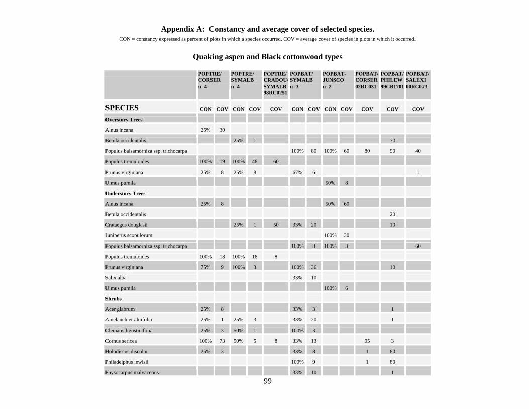
99
Appendix A: Constancy and average cover of selected species. CON = constancy expressed as percent of plots in which a species occurred. COV = average cover of species in plots in which it occurred.
Quaking aspen and Black cottonwood types
POPTRE/
CORSER n=4
POPTRE/ SYMALB n=4
POPTRE/ CRADOU/ SYMALB 98RC0251
POPBAT/ SYMALB n=3
POPBAT-JUNSCO n=2
POPBAT/ CORSER 02RC031
POPBAT/ PHILEW 99CB1701
POPBAT/ SALEXI 00RC073
SPECIES CON COV CON COV COV CON COV CON COV COV COV COV
Overstory Trees
Alnus incana 25% 30
Betula occidentalis 25% 1 70
Populus balsamorhiza ssp. trichocarpa 100% 80 100% 60 80 90 40
Populus tremuloides 100% 19 100% 48 60
Prunus virginiana 25% 8 25% 8 67% 6 1
Ulmus pumila 50% 8
Understory Trees
Alnus incana 25% 8 50% 60
Betula occidentalis 20
Crataegus douglasii 25% 1 50 33% 20 10
Juniperus scopulorum 100% 30
Populus balsamorhiza ssp. trichocarpa 100% 8 100% 3 60
Populus tremuloides 100% 18 100% 18 8
Prunus virginiana 75% 9 100% 3 100% 36 10
Salix alba 33% 10
Ulmus pumila 100% 6
Shrubs
Acer glabrum 25% 8 33% 3 1
Amelanchier alnifolia 25% 1 25% 3 33% 20 1
Clematis ligusticifolia 25% 3 50% 1 100% 3
Cornus sericea 100% 73 50% 5 8 33% 13 95 3
Holodiscus discolor 25% 3 33% 8 1 80
Philadelphus lewisii 100% 9 1 80
Physocarpus malvaceous 33% 10 1

100
Ribes aureum 50% 5 75% 19 1 33% 3 1
Ribes cereum var. cereum 25% 1 33% 1
Rosa multiflora 100% 29
Rosa woodsii 75% 10 100% 28 13 50% 3
Rubus parviflorus 30
Salix exigua 50% 8 50
Symphoricarpos albus 50% 3 100% 47 100% 77 20
Toxicodendron rydbergii 50% 1 30
Grasses and Grasslikes
Agrostis stolonifera 25% 1 3 50% 1 20
Carex lanuginosa 8
Elymus glaucus 50% 2 25% 1 33% 8
Phalaris arundinacea 25% 8 60 67% 1 100% 3
Poa pratensis 25% 3 50% 5 33% 20 50% 1 5 20
Forbs
Amsinckia lycopsoides 50% 3
Cirsium arvense 25% 20 50% 5 33% 1 1
Claytonia perfoliata ssp. perfoliata 50% 11 50% 3 33% 1 5 1
Cynoglossum officinale 67% 1
Equisetum arvense 33% 3 3
Equisetum laevigatum 100% 3
Galium aparine 25% 3 50% 17 1 33% 1 10 3
Heracleum maximum 25% 1 25% 8 33% 40
Maianthemum stellatum 100% 14 50% 8 67% 7 10 30
Osmorhiza berteroi 25% 13
Osmorhiza pupurea 33% 1 3
Urtica dioica 75% 6 50% 16 1 100% 1
Veronica anagallis-aquatica 13 Mosses/Lichens 10

101
Oregon white oak, White alder, and Conifer types
QUEGAR/ PHILEW- SYMALB n=3
QUEGAR/ ELGL 02RC063
ALNRHO/ EQUARV n=3
ALNRHO/ PHILEW n=7
ALNRHO/ BETOCC n=2
ALNRHO/ PHILEW-CORSER 02RC054
ALNRHO/ CELRET 99CB2301
PINPON/ SYMALB floodplain 00RC231
JUNOCC/ PHILEW-SALLAS 02RC013
JUNOCC/ PSESPI 02RC023
SPECIES CON COV COV CON COV CON COV CON COV COV COV COV COV COV
Overstory Trees
Acer macrophyllum 33% 60
Alnus rhombifolia 33% 60 100% 63 100% 73 100% 55 80 100
Betula occidentalis 100% 63
Juniperus occidentalis 20 20
Pinus ponderosa 50
Populus balsamorhiza ssp. trichocarpa 67% 13
Quercus garryana 100% 28 80 14% 1
Understory Trees
Acer macrophyllum 33% 30
Alnus rhombifolia 33% 8 67% 17 71% 19 100% 15 1 10
Betula occidentalis 33% 1 14% 3 100% 25
Celtis laevigata var. reticulata 14% 1 60
Crataegus douglasii 100% 7
Juniperus occidentalis 1 1
Pinus ponderosa 33% 1
Populus balsamorhiza ssp. trichocarpa 33% 1 14% 1
Prunus virginiana 67% 50 43% 2 3
Quercus garryana 100% 4 5 29% 2 1
Shrubs
Acer glabrum 100% 2 1
Amelanchier alnifolia 40
Artemisia tridentata ssp. tridentata 1 5
Clematis ligusticifolia 33% 1 71% 2 50% 1 1 1
Cornus sericea 67% 1 43% 2 100% 5 20
Holodiscus discolor 100% 7 33% 1 43% 4 100% 7 1
Philadelphus lewisii 100% 23 67% 2 100% 36 100% 70 40 3 50 10
Ribes lacustre 14% 1 100% 1 1
Rosa woodsii 67% 5 33% 1 29% 1 13 5
Rubus laciniatus 10
Rubus parviflorus 100% 20

102
Rubus ursinus 33% 1 29% 1 30
Salix lasiolepis 14% 1 20
Sambucus nigra ssp. cerulea 14% 1 100% 1 1
Symphoricarpos albus 100% 23 14% 1 100% 25 1 20 1
Toxicodendron rydbergii 33% 1 33% 1 14% 1 20
Grasses and Grasslikes
Bromus inermis 14% 1 8
Bromus sterilis 67% 5
Bromus tectorum 1 86% 3 30 30 30
Carex deweyana 33% 1 100% 2
Carex geyeri 20
Elymus glaucus 100% 6 60 67% 1 71% 10 50% 1 5 1 8
Phalaris arundinacea 33% 30
Phleum pratense 33% 1
Poa bulbosa 33% 1 8 29% 3 60 50
Poa pratensis 67% 5 10 67% 20 14% 1 100% 2 1 3
Poa secunda 5
Pseudoroegneria spicata 30
Trisetum canescens 43% 5
Forbs
Claytonia perfoliata ssp. perfoliata 33% 3 100% 16 100% 1 30 1
Lomatium dissectum 67% 1 1 29% 2
Maianthemum stellatum 67% 1
Dipsacus fullonum ssp. sylvestris 67% 1 14% 10 1
Equisetum arvense 100% 37 14% 1
Solanum dulcamara 33% 3 14% 1 100% 1
Galium triflorum 2 29% 7
Galium aparine 43% 3 50% 1 10 30 1
Circaea alpina 100% 5
Cirsium arvense 33% 1 100% 2
Equisetum hyemale 50% 10
Equisetum telmateia 50% 40
Heracleum maximum 100% 10
Hydrophyllum fendleri var.albifrons 100% 6
Hypericum perforatum 67% 1 50% 1
Urtica dioica 33% 1 29% 1 100% 6 3
Mosses/Lichens 67% 11 29% 9 100% 13

103
Thinleaf alder and Water birch types
ALNINC/ CORSER n=3
ALNINC/ SALLUT 00RC141
ALNINC/ ROSWOO 99RC173
ALNINC- BETOCC 99RC174
BETOCC/ CORSER n=5
BETOCC/ SYMALB n=3
BETOCC/ ROSWOO n=5
BETOCC/ PHILEW n=4
BETOCC/ EQARLA n=2
SPECIES CON COV COV COV COV CON COV CON COV CON COV CON COV CON COV
Overstory Trees
Alnus incana 100% 73 40 20
Betula occidentalis 33% 5 30 100% 34.2 33% 13 100% 64 75% 87 50% 30
Crataegus douglasii 20% 13
Prunus virginiana 33% 8
Salix lucida ssp. caudata 33% 13
Understory Trees
Alnus incana 33% 1 3 40
Betula occidentalis 67% 11.5 1 100% 17.7 100% 12 60% 20.3 100% 30 50% 20
Crataegus douglasii 20% 20 25% 50
Elaeagnus angustifolia 50% 1
Populus tremuloides 33% 1 33% 3
Prunus virginiana 33% 3 1 100% 23.7 40% 4.5 50% 1
Shrubs
Amelanchier alnifolia 33% 1 100% 17.7 50% 1
Artemisia ludoviciana 1 40% 3 25% 1
Clematis ligusticifolia 67% 3 3 13 20% 1 100% 11.3 80% 9.25 75% 9 100% 5.5
Cornus sericea 100% 46.7 100% 54 67% 11.5
Holodiscus discolor 33% 1 33% 20
Philadelphus lewisii 33% 8 40% 16.5 67% 16.5 20% 1 100% 38 50% 1
Ribes aureum 67% 11.5 13 3 80% 5 33% 13 40% 3 50% 2
Ribes cereum var. cereum 33% 1 3 33% 8
Ribes inerme 30
Rosa woodsii 67% 4.5 30 3 40 100% 6 67% 5.5 100% 10.8
Salix bebbiana 3
Salix exigua 1 20% 3
Salix lutea 33% 20 40 50% 1
Salix scouleriana 20% 8 33% 20
Symphoricarpos albus 33% 20 8 40% 7 100% 53.3 20% 3 25% 1
Toxicodendron rydbergii 20% 8 33% 13 20% 1 75% 10 50% 8

104
Grasses and Grasslikes
Agrostis stolonifera 50% 40
Bromus inermis 33% 3 3 20% 8 40% 45
Bromus tectorum 33% 3 100% 5.67 40% 3 25% 1
Carex lanuginosa 20% 1 50% 1
Eleocharis palustris 50% 13
Elymus glaucus 33% 3 20% 13 33% 3 40% 7 75% 6 50% 1
Elytrigia repens var. repens 33% 3 13 8 25% 3
Glyceria striata 33% 1 20% 1
Juncus balticus 40% 2 50% 3
Phalaris arundinacea 33% 13 8 3 100% 24.3 20% 3 25% 30
Poa pratensis 33% 3 3 40% 10.5 80% 28.3 75% 9
Forbs
Achillea millefolium 1 20% 1 25% 1
Anthriscus scandicina 33% 3 40% 50 25% 1
Arctium minus 100% 1.67 13 20% 1 67% 2 20% 1 25% 30
Cicuta douglasii 33% 3 20% 1 50% 3
Cirsium arvense 40 40 40% 3 60% 1.67 25% 1
Claytonia perfoliata ssp. perfoliata 3 20% 8 40% 4.5 25% 1
Dipsacus fullonum ssp. sylvestris 3 20% 3 40% 3 25% 10
Equisetum arvense 33% 13 3 20% 1 25% 30 100% 54
Equisetum laevigatum 33% 3 20% 1 25% 13 50% 3
Galium aparine 33% 13 1 1 40% 5.5 33% 30 80% 3.25 75% 2
Heracleum maximum 33% 1 8 3
Maianthemum stellatum 33% 3 1 80% 6.75 100% 34.3 60% 40 25% 5
Mimulus guttatus 33% 1 20% 1 25% 1
Osmorhiza berteroi 13
Osmorhiza occidentalis 20% 1
Ranunculus cymbalaria 33% 1 50% 3
Rumex salicifolius 3 100% 1.67 20% 1
Smilicina racemosa 33% 3 33% 8
Solidago canadensis 33% 1 3 3 40% 3 20% 1 25% 1 50% 8
Urtica dioica 100% 4 8 13 50 80% 10.5 67% 8 60% 1 50% 2 50% 1
Veronica anagallis-aquatica 33% 8 40% 3
Mosses/Lichens 25% 10

105
Redosier dogwood, Black hawthorn, Rose, and Exotic tree and shrub types
CORSER n=6
CRADOU/ SYMALB n=2
CRADOU/ ROSWOO n=7
(POPTRE) CRADOU/ HERMAX 02RC172
CRADOU/ HERMAX 99CB1103
ROSA (WOO,NUT) n=3
SALALB n=3
ACENEG n=3
AMOFRU n=3
SPECIES CON COV CON COV CON COV COV COV CON COV CON COV CON COV CON COV
Overstory Trees
Acer negundo 33% 20 100% 47
Betula occidentalis 10% 8
Crataegus douglasii 57% 63 20
Gleditsia triacanthos 67% 27
Juglans nigra 33% 50
Pinus ponderosa 10
Populus tremuloides 50
Prunus virginiana 10% 3
Salix alba 100% 70
Understory Trees
Acer negundo 33% 1 100% 31
Alnus incana 10% 8
Crataegus douglasii 100% 100 100% 36 8 60 33% 1
Gleditsia triacanthos 67% 20
Populus tremuloides 10% 3 3
Prunus virginiana 50% 3 29% 16 3 3 67% 11
Salix alba 100% 18
Shrubs
Amelanchier alnifolia 100% 10 10
Amorpha fruticosa 100% 77
Artemisia ludoviciana 10% 1 43% 2 67% 1
Cornus sericea 100% 76 3
Holodiscus discolor 50% 20
Philadelphus lewisii 30% 8 100% 51 14% 8 33% 40
Physocarpus malvaceous 50% 20
Ribes aureum 80% 12 100% 7 33% 13 33% 13
Rosa nutkana 33% 13
Rosa woodsii 80% 13 100% 22 3 67% 50
Spiraea betulifolia 100% 15
Symphoricarpos albus 40% 6 100% 55 57% 6 1 33% 1

106
Grasses and Grasslikes
Agrostis interrupta 100% 11
Agrostis stolonifera 10% 1 33% 3 67% 22
Bromus carinatus 30 33% 1 33% 1
Bromus tectorum 50% 6 100% 7 71% 18 33% 3 67% 20 100% 34
Carex lanuginosa 33% 1
Elymus glaucus 20% 3 57% 9 33% 1
Glyceria striata 10% 1 33% 8
Juncus balticus 14% 3 33% 30
Lolium pratense 29% 1 67% 50 33% 60
Phalaris arundinacea 60% 8 43% 6 3 67% 36 67% 37 33% 1 100% 48
Poa pratensis 10% 8 50% 20 43% 8 1 20 33% 8 67% 35 100% 8
Polypogon monspeliensis 67% 1
Forbs
Agastache urticifolia 50% 1 43% 6 33% 1 33% 8
Amsinckia lycopsoides 20% 3 29% 2 67% 11 33% 1
Anthemis cotula 100% 1
Anthriscus scandicina 20% 20 50% 1 29% 14 33% 1 67% 20 33% 1
Arnica cordifolia 50% 30
Chenopodium album 33% 1 33% 1 100% 2
Cirsium arvense 40% 5 86% 5 8 3 33% 20 67% 2 67% 1 33% 3
Claytonia perfoliata ssp. perfoliata 40% 4 50% 3 71% 5 33% 1
Conium maculatum 10% 3 29% 8 67% 2 67% 11
Equisetum arvense 14% 1 67% 11
Equisetum hyemale 67% 40 33% 30
Galium aparine 40% 3 100% 2 100% 3 1 33% 8 33% 1 33% 1
Heracleum maximum 40% 12 14% 3 20 40
Hydrophyllum fendleri var.albifrons 90 30 33% 3
Maianthemum stellatum 70% 6 86% 13 1
Mimulus guttatus 20% 1 14% 3 33% 1 67% 1
Osmorhiza pupurea 100% 1
Rumex crispus 50% 1 100% 1
Solidago canadensis 40% 1 29% 2 20 33% 40 67% 2 33% 3 67% 2
Urtica dioica 70% 12 86% 7 3 10 67% 2 100% 4 67% 1
Veronica anagallis-aquatica 10% 1 29% 2 67% 2
Mosses/Lichens 50% 10 10 67% 8

107
Sandbar, Yellow, Arroyo, Peachleaf, and Bebb willow types
SALEXI n=10
SALLUT- SALEXI n=6
SALLUT/ CORSER n=2
SALLUT-PHILEW 00RC151
SALLUT/ EQUAR 00RC201
SALLAS n=3
SALAMY/ EQUARV 02RC081
SALAMY-BETOCC 00RC172
SALBEB 02RC193
SPECIES CON COV CON COV CON COV COV COV CON COV COV COV COV
Trees
Alnus rhombifolia 33% 1
Betula occidentalis 17% 1 20 3
Crataegus douglasii 20% 3
Elaeagnus angustifolia 10% 3 1
Populus balsamorhiza ssp. trichocarpa 17% 13 1
Prunus virginiana 10% 13
Salix amygdaloides 100 80
Shrubs
Artemisia ludoviciana 20% 8 17% 1
Artemisia tridentata ssp. tridentata 33% 1
Clematis ligusticifolia 30% 1.67 13 67% 2.5 20
Cornus sericea 29% 40 1 1
Holodiscus discolor 1 67% 1.5
Philadelphus lewisii 20 100% 3 1
Ribes aureum 20% 1 67% 4
Rosa nutkana 17% 20 1
Rosa woodsii 30% 3.33 17% 1 14% 30 33% 1 1
Salix bebbiana 14% 8 90
Salix exigua 100% 61 100% 51 14% 20 3
Salix lasiolepis 100% 98.7
Salix lutea 30% 1 100% 36 29% 60 80 70
Symphoricarpos albus 10% 1 14% 1
Grass and Grasslikes
Agrostis scabra 67% 1
Agrostis stolonifera 20% 4.5 50% 40 29% 2 1 1
Bromus commutatus 33% 2
Bromus inermis 33% 17 13
Bromus japonicus 10% 50
Bromus tectorum 40% 20.3 14% 1 100% 1.67 1
Carex lanuginosa 1

108
Elymus glaucus 33% 1
Elytrigia repens var. repens 60% 14.3 33% 7
Glyceria striata 10% 5
Lolium arundinaceum 50% 15
Phalaris arundinacea 70% 47.3 33% 25 14% 13 8 70 3
Pharagmites australis 3
Poa bulbosa 10% 1 67% 1
Poa palustris 33% 7
Poa pratensis 20% 2 17% 30 14% 3
Scirpus microcarpus 30 1 1
Trisetum canescens 33% 2
Forbs
Achillea millefolium 33% 1
Anthriscus scandicina 10% 1 17% 1
Apocynum cannabinum 10% 8 3
Cardaria draba 20% 20.5
Circaea alpina 14% 8
Cirsium arvense 60% 4.5 33% 2
Claytonia perfoliata ssp. perfoliata 14% 3 33% 20
Conium maculatum 30% 6.33
Equisetum arvense 10% 1 33% 3 14% 3 1 30 3
Equisetum hyemale 20% 5.5 50% 4 70 30
Equisetum laevigatum 10% 1 33% 8 20
Euthamia occidentalis 20% 4.5 17% 8
Galium aparine 30% 2.33 29% 5.5 67% 1
Heracleum maximum 14% 13
Lycopus americanus 50% 3
Mimulus guttatus 20% 5.5 14% 3 33% 2
Plantago major 20% 4 14% 3
Polemonium pectinatum 10% 1
Potentilla argentea 67% 1
Rumex salicifolius 40% 9.25 14% 1 33% 1
Solidago canadensis 40% 1.5 17% 1 3
Urtica dioica 20% 2 33% 1 29% 3 67% 1 1 3 1
Veronica anagallis-aquatica 10% 13 17% 3 14% 3
Mosses/Lichens 10% 5 33% 11 33% 5 10

109
Netleaf hackberry, Mockorange, Chokecherry, Serviceberry, White sagebrush and Smooth sumac types
CELRET/ PHILEW n=4
PHILEW/ SYMALB n=4
PHILEW/ CLELIG n=6
PRUVIR n=3
AMEALN-PHILEW n=3
AMEANL/ TOXRAD n=2
ARTLUD n=10
RHUGAL n=3
SPECIES CON COV CON COV CON COV CON COV CON COV CON COV CON COV CON COV
Overstory Trees
Betula occidentalis 25% 30
Celtis laevigata var. reticulata 100% 78
Prunus virginiana 67% 12
Understory Trees
Betula occidentalis 25% 10
Celtis laevigata var. reticulata 100% 23 33% 1
Crataegus douglasii 50% 1 33% 1
Populus balsamorhiza ssp. trichocarpa 33% 3 33% 3 10% 1
Prunus virginiana 50% 40 33% 10 33% 10 100% 25 50% 20 10% 1
Shrubs
Amelanchier alnifolia 67% 42 100% 22
Artemisia ludoviciana 33% 1 33% 30 50% 1 100% 16
Artemisia tridentata ssp. tridentata 33% 1 33% 3 20% 5
Artemisia tridentata ssp. wyomingensis 67% 17
Clematis ligusticifolia 50% 1 33% 20 33% 20 33% 1 33% 3 50% 3 20% 5
Eriogonum niveum 67% 7 20% 1 33% 5
Holodiscus discolor 50% 2 67% 1
Philadelphus lewisii 100% 30 100% 27 100% 27 33% 20 33% 30 50% 8 40% 2
Physocarpus malvaceous 33% 1 33% 1
Rhus glabra 75% 4 33% 1 100% 53
Ribes aureum 50% 3 33% 3 33% 3 67% 7 50% 8 10% 1
Rosa canina 50% 1 33% 3 10% 1
Rosa woodsii 33% 1 33% 1 67% 28 100% 8 10% 1
Rubus ursinus 50% 40 33% 1 33% 1 33% 20
Salix exigua 25% 10 67% 7 10% 3
Salix lasiolepis 33% 20
Sambucus nigra ssp. cerulea 75% 5
Symphoricarpos albus 100% 7 100% 7 33% 1
Toxicodendron rydbergii 100% 3 33% 30 33% 30 33% 1 100% 30
Grass and Grasslikes
Achnatherum occidentale 33% 30

110
Agrostis interrupta 33% 8 50% 1 30% 8
Bromus japonicus 33% 8 33% 3 50% 10 30% 30
Bromus tectorum 100% 48 67% 9 67% 9 100% 28 100% 33 100% 9 80% 15 100% 53
Calamagrostis rubescens 33% 5 33% 5
Dichanthelium oligosanthes var. scribnerianum 33% 60
Elymus glaucus 67% 9 67% 9 33% 10 50% 3 10% 1
Elymus lanceolatus 33% 8 10% 13
Elytrigia repens var. repens 60% 10
Festuca idahoensis 33% 3 50% 1
Leymus cinereus 33% 3 50% 8 20% 2
Muhlenbergia richardsonis 20% 3
Phalaris arundinacea 33% 10 33% 10 10% 1 33% 1
Poa bulbosa 25% 1 33% 60 67% 12 30% 8 67% 6
Poa palustris 67% 6.5 67% 7
Poa pratensis 25% 40 67% 5.5 67% 6 33% 1 20% 1 33% 30
Poa secunda 33% 8 33% 3 10% 1
Poa secunda (junifolia) 100% 8 30% 8
Polypogon monspeliensis 50% 13 20% 1
Pseudoroegneria spicata 33% 3 33% 3 100% 3 10% 1 33% 30
Forbs
Achillea millefolium 25% 1 33% 1 67% 1 80% 1
Anthriscus scandicina 33% 5 33% 60
Arctium minus 25% 1 33% 1 33% 1 10% 1
Cirsium arvense 67% 1 67% 1 30% 2
Claytonia perfoliata ssp. perfoliata 75% 2 67% 9 10% 1 33% 1
Collinsia grandiflora 33% 1 33% 1 10% 1 33% 1
Cynoglossum officinale 100% 3 33% 1 33% 1 33% 1 20% 1 67% 1
Dipsacus fullonum ssp. sylvestris 50% 2 33% 1 50% 3 30% 2 33% 1
Equisetum arvense 33% 1 33% 1 10% 40
Galium aparine 50% 2 33% 3 33% 3 33% 8 33% 8 30% 3 33% 1
Heracleum maximum 33% 3 33% 3
Hydrophyllum fendleri var.albifrons 33% 1 33% 1 33% 1
Lactuca serriola 75% 1 33% 13 33% 13 33% 1 33% 1 30% 2 67% 1
Polemonium pectinatum 33% 3
Urtica dioica 50% 2 50% 3 10% 1 33% 1
Verbascum thapsus 50% 2 30% 6 33% 1
Viola glabella 33% 30 33% 30 33% 40
Mosses/Lichens 25% 10 67% 10 67% 10

111
Sedge, Rush and Bulrush types
CARPEL-ELEPAL n=7
CARPEL- ARGANS n=4
CARPEL-CARSIM n=2
CARNEB-ARGANS n=6
CARAQU 02RC032
CARURT n=3
ELEPAL n=6
JUNBAL-ARGANS n=5
JUBA- PHAARU 99RC62
SCHACU n=3
SCIFLU 99CB2402
SPECIES CON COV CON COV CON COV CON COV COV CON COV CON COV CON COV COV CON COV COV
Trees
Elaeagnus angustifolia 14% 13 Populus balsamorhiza ssp. trichocarpa 1 Populus tremuloides 1
Shrubs Salix exigua 29% 2 17% 2
Grass and Grasslikes
Agrostis exarata 14% 1 33% 3 Agrostis stolonifera 43% 2 25% 3 50% 8 33% 5.5 20% 1 Calamagrostis canadensis 14% 3 25% 3
Carex aquatilis var. aquatilis 90 Carex lanuginosa 100% 59 100% 73 100% 34 50% 17 1 Carex nebrascensis 25% 3 50% 30 100% 65
Carex praegracilis 50% 1 40% 37 Carex simulata 100% 45 Carex stipata 33% 13
Carex utriculata 100% 57 Eleocharis palustris 86% 15 50% 2 50% 8 50% 5 33% 3 100% 70 3 33% 1 3 Eleocharis rostellata 50% 1
Glyceria grandis 17% 8 Glyceria striata 17% 8 67% 16 17% 1 Hordeum brachyantherum 40% 1
Hordeum jubatum 50% 2 33% 1 17% 1 40% 3 Juncus balticus 86% 21 100% 43 100% 11 83% 24 33% 3 50% 26 100% 85 80 33% 1 Juncus longistylis 25% 1
Juncus tenuis 1 Phalaris arundinacea 43% 17 25% 3 50% 3 50% 34 100% 15 50% 8.7 13 33% 1 30 Phleum pratense 20
Poa pratensis 14% 3 50% 3 17% 1 5 Polypogon monspeliensis 17% 8 33% 2 40% 2 Schoenoplectus acutus 25% 1 67% 17 100% 92
Schoenoplectus americanus 29% 7 50% 2 50% 1 17% 13 17% 13 20% 1 3 Schoenoplectus fluviatilis 80 Scirpus microcarpus 14% 1 50% 3
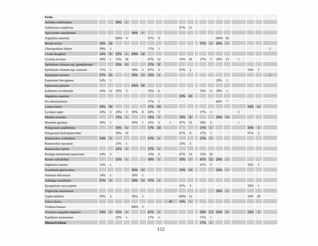
112
Forbs Achillea millefolium 50% 1 Anthriscus scandicina 67% 11
Apocynum cannabinum 50% 1 Argentina anserina 100% 4 67% 9 100% 30 Berula erecta 29% 16 17% 1 20% 1
Chenopodium album 29% 2 17% 1 3 Cicuta douglasii 14% 8 25% 1 100% 14 Cirsium arvense 29% 1 75% 18 67% 12 33% 30 17% 5 20% 13 1
Epilobium ciliatum ssp. glandulosum 25% 13 17% 8 Epilobium ciliatum ssp. watsonii 71% 1 50% 3 67% 3 67% 2 33% 1 Equisetum arvense 57% 25 50% 13 33% 3 3
Equisetum laevigatum 14% 1 20% 1 Equisetum palustre 100% 39 Euthamia occidentalis 14% 13 25% 3 33% 6 33% 11 20% 1
Impatiens capensis 33% 20 Iris missouriensis 17% 1 60% 7 Lemna minor 29% 30 17% 50 33% 13
Lycopus asper 43% 6 25% 3 50% 8 50% 5 17% 3 3 Mentha arvensis 25% 1 33% 3 33% 8 20% 13 Mimulus guttatus 29% 1 50% 1 33% 3 1 67% 22 50% 5 1
Polygonum amphibium 50% 6 17% 20 17% 1 33% 1 Polygonum hydropiperoides 50% 19 67% 8 17% 1 67% 2 Ranunculus cymbalaria 14% 3 17% 1 17% 1
Ranunculus macounii 25% 1 33% 3 Ranunculus repens 25% 3 17% 1 Rorippa nasturtium-aquaticum 14% 3 33% 2 67% 24 33% 30
Rumex salicifolius 25% 1 50% 1 33% 3 67% 12 20% 1 Sagittaria cuneata 14% 1 67% 3 33% 1 Scutellaria galericulata 50% 13 33% 13 20% 1
Solanum dulcamara 14% 1 50% 1 Solidago canadensis 57% 4 50% 13 17% 3 Sparganium eurycarpum 67% 2 33% 1
Triglochin maritimum 20% 3 Typha latifolia 29% 3 50% 1 100% 13 33% 20 Urtica dioica 40 33% 1
Verbena hastata 100% 2 Veronica anagallis-aquatica 14% 3 25% 3 67% 5 50% 5.3 20% 8 33% 3 Xanthium strumarium 25% 1 17% 1 17% 1
Mosses/Lichens 17% 1

113
Grass types
AGRSTO-ELYREP n=9
ALOGEN n=3
BROINE 99RC194
DESCES ELYREP n=6
GLYSTR n=6
PHAR n=36
SPAPEC 99CB2403
SPECIES CON COV CON COV COV COV CON COV CON COV CON COV COV
Trees
Populus balsamorhiza ssp. trichocarpa 11% 3
Salix alba 11% 3
Shrubs
Salix exigua 11% 1 11% 2 3
Salix lutea 11% 3 1
Grass and Grasslikes
Agrostis capillaris 11% 13 3% 8
Agrostis stolonifera 100% 33 67% 30 6 83% 41 14% 4
Alopecurus geniculatus 100% 36
Bromus inermis 22% 3 98 17% 1 11% 6
Bromus tectorum 22% 6 33% 1 17% 60 3% 3
Carex aquatilis var. aquatilis 17% 20
Carex lanuginosa 33% 1 17 33% 8 3% 3
Carex nebrascensis 20 50% 34
Carex praegracilis 8 33% 25 6% 8
Deschampsia cespitosa 45
Eleocharis palustris 22% 8 67% 35 12 17% 8 17% 1 22% 3 1
Elytrigia intermedia 11% 1 33% 55
Elytrigia repens var. repens 89% 12 100% 58 17% 3 17% 17
Glyceria striata 11% 3 33% 13 100% 32 3% 1
Juncus balticus 67% 5 33% 1 45 17% 1 50% 35 6% 7
Juncus bufonius 22% 1 33% 3 2 17% 8 1
Leymus cinereus 11% 3 17% 1
Lolium arundinaceum 11% 70 17% 8 3% 13
Phalaris arundinacea 44% 2 67% 8 33% 7 67% 24 100% 85 20
Poa compressa 3% 50
Poa palustris 33% 11
Poa pratensis 22% 8 33% 1 6 50% 10 50% 2 25% 7
Polypogon monspeliensis 44% 2 33% 20 17% 3 33% 1 8% 2
Schoenoplectus acutus 11% 3 8% 1
Schoenoplectus americanus 3
Schoenoplectus fluvatilis 3
Spartina pectinata 100

114
Forbs
Achillea millefolium 17% 10 3% 1
Argentina anserina 1 3% 8
Artemisia biennis 17% 1 33% 1
Cicuta douglasii 11% 3 17% 1 17% 3 3% 8
Cirsium arvense 56% 2 33% 13 1 83% 7 17% 3 31% 4
Cirsium vulgare 11% 1 17% 8 6% 1
Conium maculatum 17% 15 3% 1
Dipsacus fullonum ssp. sylvestris 11% 3 17% 8 8% 7
Epilobium ciliatum ssp. watsonii 22% 2 33% 1 8 17% 20 14% 2
Equisetum arvense 17% 1 22% 3 1
Equisetum laevigatum 22% 27 33% 7 3% 8 1
Equisetum sp 17% 1 6% 3
Euthamia occidentalis 22% 2 33% 5 25% 10
Galium aparine 17% 3 17% 1 3% 1
Glycyrrhiza lepidota 3
Impatiens capensis 17% 3
Iris missouriensis 11% 13 17% 3
Lactuca serriola 11% 3 33% 1 17% 30 3% 1
Lemna minor 33% 1 33% 18
Lycopus asper 11% 50 1 17% 13 6% 2
Matricaria discoidea 33% 2 3% 1
Medicago lupulina 22% 2 67% 2 17% 1 33% 3
Melilotus alba 11% 3 33% 3
Melilotus officinalis 11% 70
Mentha arvensis 22% 5 33% 3 17% 1
Mimulus guttatus 22% 1 33% 8 67% 6 11% 3
Plantago major 56% 6 17% 1 6% 2
Polygonum amphibium 33% 30 17% 1 33% 1 3% 3
Potentilla rivalis 11% 13 3% 1
Ranunculus cymbalaria 11% 3 67% 1 17% 3
Rorippa nasturtium-aquaticum 33% 20 50% 11 14% 4
Rumex crispus 11% 3 33% 1 3% 1 1
Rumex salicifolius 67% 3 33% 1 50% 3 50% 7 19% 3
Solanum dulcamara 17% 8 11% 5
Solidago canadensis 17% 1 22% 2 1
Trifolium repens 22% 42 33% 1
Urtica dioica 11% 1 33% 1 17% 8 17% 30 22% 2
Veronica anagallis-aquatica 22% 1 67% 2 67% 8 11% 2
Mosses/Lichens 22% 7 33% 8 6% 6

115
Black greasewood, Saltgrass, Basin wildrye, Cordgrass, Annual hairgrass, and Bluebunch wheatgrass types
SARVER/ DISSPI n=4
DISSPI/ CARPRA n=8
DISSPI- SCHAME n=3
SPAGRA n=2
LEYCIN/ DISSPI n=3
LEYCIN/ CARPRA n=6
JUNBAL n=2
LEYCIN/ BROTEC n=5
PSESPI n=3
DESDAN n=3
SPECIES CON COV CON COV CON COV CON COV CON COV CON COV CON COV CON COV CON COV CON COV
Trees
Elaeagnus angustifolia 33% 8 50% 3
Shrubs
Artemisia ludoviciana 50% 1 20% 3
Artemisia tridentata ssp. tridentata 20% 13 33% 30
Artemisia tridentata ssp. wyomingensis 33% 3
Chrysothamnus viscidiflorus 20% 30
Ericameria nauseosa 20% 1 33% 8
Rosa woodsii 17% 1 50% 1 20% 3
Sarcobatus vermiculatus 100% 43 50% 1
Grass and Grasslikes
Agrostis interrupta 50% 8 38% 2 17% 13 33% 30
Agrostis stolonifera 17% 1 50% 13
Bromus hordeaceus ssp. hordeaceus 17% 8
Bromus japonicus 20% 20 33% 8 33% 3
Bromus tectorum 50% 10 50% 3 50% 3 100% 28 100% 13 100% 13
Carex praegracilis 50% 1 75% 18 67% 50 100% 2 100% 8 100% 35 50% 30 20% 1
Deschampsia danthonioides 67% 29
Distichlis spicata 100% 46 100% 56 100% 24 50% 8 100% 10 67% 9
Eleocharis palustris 33% 1
Elymus lanceolatus 33% 30
Elytrigia intermedia 50% 2 38% 11 33% 20
Elytrigia repens var. repens 25% 1 33% 3 33% 27 50% 3 33% 1
Hordeum jubatum 25% 1 25% 1 67% 16 50% 1 33% 1
Hordeum murinum ssp. leporinum 67% 1
Juncus balticus 25% 1 38% 15 67% 27 50% 40 50% 10 100% 65 Juncus bufonius 33% 3
Leymus cinereus 50% 7 33% 3 100% 8 100% 32 100% 38 Poa bulbosa 33% 1 33% 13
Poa pratensis 50% 3 33% 1 83% 20 50% 50

116
Poa secunda 33% 40 100% 8 33% 8
Poa secunda (juncifolia) 63% 30 33% 20 100% 51 33% 7 40% 6 33% 1
Polypogon monspeliensis 13% 1 33% 1
Pseudoroegneria spicata 100% 6
Puccinellia lemmonii 13% 3 33% 30 33% 1
Schoenoplectus americanus 25% 1 13% 1 100% 47
Scirpus nevadensis 13% 3 50% 60
Spartina gracilis 50% 15 33% 3 100% 50 100% 6 67% 9
Taeniatherum caput-medusae 33% 30
Vulpia spp 33% 1 33% 10
Forbs
Cirsium vulgare 13% 1 67% 1 17% 1 Equisetum laevigatum 13% 3 33% 1 50% 3 17% 1 20% 1 33% 20
Aster ericoides var. pansus 13% 3 17% 1 Lepidium latifolium 13% 33% 8 50% 1
Triglochin maritimum 13% 8 Potentilla argentea 25% 1 33% 8
Achillea millefolium 25% 5 67% 1 33% 8 50% 3 20% 3 67% 1 100% 4 Grindelia squarrosa 25% 2 33% 40
Argentina anserina 25% 1 67% 5
Lactuca serriola 75% 1 50% 1 33% 30 100% 6 67% 6 50% 13 20% 3 33% 1 67% 5 Lactuca tatarica var. pulchella 33% 5 50% 3
Descurainia pinnata 17% 3 20% 13 33% 3 Sisymbrium altissimum 17% 3 50% 20 40% 3 33% 80
Chenopodium album 50% 5 67% 3 50% 1 17% 1 20% 8 Senecio serra 17% 1 20% 3
Sonchus sp. 17% 3 100% 20 Urtica dioica 17% 1 50% 1 20% 1
Cirsium arvense 50% 3 67% 7 100% 45 20% 3 Lepidium perfoliatum 25% 3 83% 3 40% 12 100% 16 Potentilla rivalis 20% 3 33% 1 Plantago patagonica 67% 2 Asclepias speciosa 25% 1 50% 1 Lomatium columbianum 33% 1 Polemonium pectinatum 20% 20 Pteryxia terebinthina var. terebinthina 33% 8 Solidago canadensis 50% 3 20% 1 Sphaeralcea munroana 20% 1
Mosses/Lichens 33% 5

117
Forb types
RORNAS n=13
EQUARV n=10
LOMGRA n=3
TYPLAT n=4
TYPANG-TYPLAT 00RC031
SPAEUR 98RC0231
ELOCAN 99CB400
RANAQU 98RC0042
SPECIES CON COV CON COV CON COV CON COV COV COV COV COV
Understory trees
Populus balsamorhiza ssp. trichocarpa 10% 8
Salix alba 10% 10 25% 1 1
Salix amygdaloides 8% 1 10% 5
Shrubs
Amelanchier alnifolia 10% 8
Artemisia ludoviciana 20% 5 67% 2
Artemisia tridentata ssp. wyomingensis 33% 1
Clematis ligusticifolia 10% 3 67% 1
Cornus sericea 20% 1
Philadelphus lewisii 20% 6
Ribes aureum 20% 1
Salix exigua 20% 6 25% 1 1
Grasses and Grasslikes
Agrostis stolonifera 38% 9 10% 3
Bromus inermis 8% 1 10% 3
Bromus tectorum 8% 1 67% 1
Carex lanuginosa 8% 1
Carex nebrascensis 8% 8
Eleocharis palustris 15% 2 40% 16 33% 1 13
Elytrigia repens var. repens 33% 20
Glyceria striata 15% 3 20% 2
Juncus balticus 15% 7 50% 33 25% 30 3
Phalaris arundinacea 8% 13 20% 17 50% 12 1 3 1
Poa bulbosa 20% 1 100% 2
Poa pratensis 8% 1 70% 11 1
Poa secunda 67% 3
Schoenoplectus acutus 8% 3 10% 1 50% 22 3
Schoenoplectus americanus 8% 1 10% 1 3

118
Scirpus microcarpus 30% 14 50% 2
Forbs
Amsinckia lycopsoides 50% 1
Anthriscus scandicina 23% 4
Arctium minus 8% 1 20% 1
Berula erecta 23% 23
Chenopodium album 33% 3
Cicuta douglasii 15% 6
Cirsium arvense 30% 5
Conium maculatum 8% 10 20% 41
Convolvulus arvensis 33% 8
Descurainia pinnata 33% 1 25% 1
Dipsacus fullonum ssp. sylvestris 8% 10 30% 4 25% 1
Elodea canadensis 20
Epilobium ciliatum ssp. watsonii 31% 3 10% 1
Equisetum arvense 31% 13 100% 56 50% 9
Grindelia squarrosa 33% 3
Lemna minor 38% 5 25% 13 3 3
Lomatium grayi 100% 47
Lycopus asper 15% 2 20% 1
Mimulus guttatus 69% 7 20% 2 33% 1 25% 1
Ranunculus aquatilis 8% 1 70
Rorippa nasturtium-aquaticum 92% 44 20% 21 25% 50
Rumex crispus 15% 1 40% 1
Sagittaria cuneata 20
Senecio serra 10% 30
Solidago canadensis 15% 1 30% 7
Sparganium eurycarpum 98
Typha angustifolia 40
Typha latifolia 15% 1 20% 1 100% 68 60
Urtica dioica 38% 1 10% 13
Veronica americana 8% 1 30% 5
Veronica anagallis-aquatica 85% 4 10% 1 25% 1 3 1
Zannichellia palustris 1
Mosses/Lichens 23% 12 20% 1 33% 10 20