Embed Size (px)
DESCRIPTION
Discover the lakes of Val di Sole
Citation preview
www.valdisole.net
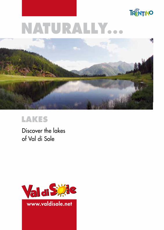
NATURALLY...
LAKESDiscover the lakes of Val di Sole
VALDISOLE
INTR
OD
UCTI
ON
A multitude of lakes to discoverVal di Sole’s abundance of water, which is definitely unique, includes a multitude of lakes that embellish this already spectacular landscape. There are over 100 lakes throughout the valley, a record in all of Trentino which has a total of 297 lakes. The lakes in Val di Sole cover an area that is less than 1 km (78,4 hectares), of the total 35 km that are covered by all the la-kes in Trentino. The majority of these lakes are quite small but fascinating. They are located in the Ortles - Cevedale mountain range, between the Peio and Rabbi valleys in the Stelvio National Park, where the incredible power of the glacial residuals, in both the glacial cirques and along the valley, have left us these precious pearls. Many of these lakes are often clustered together like those at the foot of Monticelli and in Strìno (Passo Tonale), Montózzo (upper Val del Monte, Pèio), the Corvo and Sternài lakes (Val di Rabbi); while other lakes are isolated such as Barco Lake and Caprioli Lake), all with the same unmistakable tones of blue and turquoise. There are numerous excursions and walks that will allow you to reach all these lakes: this brief brochure describes 17 different excursions, with diverse difficulty levels, but considering the beauty of these lakes, it is de-finitely worth trying all of them: don’t miss out on these natural beauties!
We hope you enjoy reading our brochure and have a safe excursion!
Lago Covel (Covel Lake) pag. 3
Giro dei Laghi del Cevedale (The Cevedale Lakes excursion) 4
Lago di Vallombrina* (Vallombrina Lake)* 5
I Laghi Corvo (Corvo Lakes) 8
Lago Rotondo e Lago Alto (Rotondo Lake and Alto Lake) 9
Laghi Sternai* (Sternai Lakes)* 10
Lago Monticello (Monticello Lake) 13
Laghetto d’Albiolo superiore (The Albiolo Superiore Lake) (an alternative route to discover WWI ruins) 14
Giro dei Laghi di Strino (The Strino Lakes excursion) 15
Lago Denza (Denza Lake) 16
Lago Barco e Lago Piccolo (Barco Lake and Piccolo Lake) 17
Lago Stablo e Lago dei Caprioli / Fazzon (Stablo Lake and Caprioli / Faz-zon Lake) 18
Laghi del Malghetto di Mezzana superiore (Malghetto di Mezzana superiore Lakes) 19
Lago Malghette (Malghette Lake) 20
I Tre Laghi (The Three Lakes) 21
Lago delle Salare* (Salare Lake)* 22
Itinerario dei “Cinque Laghi” (“Five Lakes” excursion) 25
TABLE
OF
CO
NTE
NTS
Production and introductory text: APT Val di Sole.Photos and itinerary descriptions: Tiziano Mochen - MaléGraphic lay-out and printing: Graffite Studio Malé
* A2-dayexcursionisrecommended
USEFUL TREKKING TIPSUseful tips before starting off on an excursion
RECOMMENDED EQUIPMENT
VALDISOLE
Val di Sole is definitely the perfect place for excursions and alpine itinera-ries with an infinite variety of landscapes and mountains that vary from an altitude of 700 m, at the lowest part of the valley, all the way to 3700 m on the highest peaks. There are three main mountain ranges that are part of the valley: the Ortles-Cevedale to the north, the Adamello-Presa-nella to the west, and the Brenta Dolomites to the southwest. All trails have been blazed in red and white with the SAT (Trentino Alpine Association) trail marker with the corresponding number in black. When deciding on an excursion in Val di Sole, the only problem will be choosing which one to try: the vast mountain territory that surrounds the valley of-fers an infinite number of possibilities, both for experts or for those with less training and experience. In addition to various difficulty levels, both for rock-climbing or panoramic high altitude itineraries amongst magni-ficent peaks and glaciers, there are also numerous trekking itineraries or simple but fascinating naturalistic excursions.
˜ 4LAND 126 Val di Sole 1:25.000 MAP˜ KOMPASS 095 Val di Sole, Pejo e Rabbi 1:35.000 MAP
˜ KOMPASS 072 Parco Nazionale dello Stelvio (Ortles-Cevedale) 1:50.000 MAP
˜ KOMPASS 073 Gruppo di Brenta 1:50.000 MAP˜ TABACCO Val di Peio - Val di Rabbi - Val di Sole 1:25.000 MAP
˜ TABACCO Dolomiti di Brenta - Adamello Presa-nella - Val di Sole 1:50.000 MAP
Guides and maps of the trails can be purchased in the various stationary and newspaper shops throughout the valley, and tourist information offices.
THE MOST IMPORTANT RULES TO FOLLOW DURING MOUNTAIN HIKES:
• never hike alone in the mountains;
• inform someone (a relative or a friend or the mountain hut where you will be stopping) of the trail you will be following;
• make sure that you have all the necessary equi-pment for the hike;
• constantly monitor the weather conditions; if in doubt, go back!
• carefully prepare your excursion: check the we-ather forecast, study your itinerary on the ap-propriate map, etc.; or decide if you would like to be accompanied by the Alpine Guides or the Park’s Guides.
• waterproof clothing, light and warm (a first layer of clothing in polypropylene material is recommended, followed by a second isolating layer of material such as fleece or wool and a third waterproof layer such as a wind jacket in nylon or gore-tex fabric, long pants);
• trekking boots with rubber soles (avoid wearing running shoes);
• gloves, cap and a change of clothing (knee-length socks, underclothes, and possibly a light tracksuit);
• backpack (do not pack unnecessary items; the recommended maximum weight is 5-8kg which may vary according to the length of your hike);
• it may be useful to bring a compass
RECOMMENDED MAPS
2
VALDISOLE
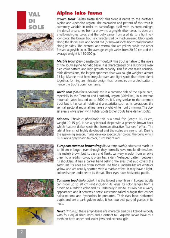
Alpine lake faunaBrown trout (Salmo trutta fario): this trout is native to the northern Alpine and Apennine region. The coloration and pattern of this trout is extremely variable in order to camouflage itself with its surroundings: the dorsal area varies from a brown to a greyish-silver color, its sides are a yellowish-grey color, and the belly varies from a white to a light yel-low color. The brown trout is characterized by medium-sized black spots along the dorsal area and bright red (or brown) spots horizontally located along its sides. The pectoral and ventral fins are yellow, while the other fins are a greyish color. The average length varies from 20-30 cm and the average weight is 150-300 g.
Marble trout (Salmo trutta marmoratus): this trout is native to the rivers of the south alpine Adriatic basin. It is characterized by a distinctive mar-bled color pattern and high growth capacity. This fish can reach conside-rable dimensions, the largest specimen that was caught weighed almost 25 kg. Marble trout have irregular dark and light spots that often blend together, forming an intricate design that resembles a marbled pattern, hence the trout’s common name.
Arctic char (Salvelinus alpinus): this is a common fish of the alpine arch, especially in the Trentino and Lombardy region (Valtellina), in numerous mountain lakes located up to 2600 m. It is very similar to the common trout but it has certain distinct characteristics such as its coloration: the ventral, pectoral and anal fins have a bright white front trimming. The dor-sal area is olive green with lighter spots (other trouts have darker spots).
Minnow (Phoxinus phoxinus): this is a small fish (length 10-13 cm, weight 10-15 gr.). It has a cylindrical shape with a greenish-brown back which features darker spots that form an attractive “banded” effect. The lateral line is not highly developed and the scales are very small. During the spawning season, males develop spectacular colors; the belly, which is usually a greyish-white color, turns bright red.
European common brown frog (Rana temporaria): adults can reach up to 10 cm in length, even though they normally have smaller dimensions. It is mainly brown but its back and flanks can vary in color from an olive green to a reddish color; it often has a dark V-shaped pattern between its shoulders; it has a darker band behind the eyes that also covers the eardrums. Its sides are often spotted. The frogs’ underbellies are white or yellow and are usually spotted with a marble effect. It may have a light-colored stripe underneath its throat. Their eyes have horizontal pupils.
Common toad (Bufo bufo): it is the largest amphibian in Europe, adults can grow up to 20 cm (not including its legs). Its color ranges from a brown to a reddish color and its underbelly is white. Its skin has a warty appearance and it secretes a toxic substance called bufagin that causes hallucinations and hypnotizes its predators. Their eyes have horizontal pupils and are a dark-golden color. It has two oval parotid glands in its neck.
Newt (Triturus): these amphibians are characterized by a lizard-like body with four equal sized limbs and a distinct tail. Aquatic larvae have true teeth on both upper and lower jaws and external gills.
3
VALDISOLE
1Lago Covel
Elevation amsl: 1839. Location: Peio Catchment basin:Noce – Rio di ViozMountain chain: OrtlesHiking time: 0.50 min.
Difficulty: T – TouringElevation gain: 260 mSAT trail n°: 105 - 125 - 127
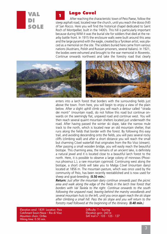
After reaching the characteristic town of Peio Paese, follow the steep asphalt road, located near the church, until you reach the dosso (hill) of San Rocco. Here you will find the historical chapel dedicated to Saint Roch of Montpellier, built in the 1400’s. This hill is particularly important because during WWI it was the burial site for soldiers that died at the ne-arby battle front. In 1915 the enclosure walls were built around this area and the large pyramid with the eagle, created by a Tyrolean artist, was pla-ced as a memorial on the site. The soldiers buried here came from various nations (Austrians, Polish and Russian prisoners, several Italians). In 1921, the bodies were exhumed and brought to the war memorial in Rovereto. Continue onwards northwest and take the forestry road that clearly
enters into a larch forest that borders with the surrounding fields just above the town. From here, you will begin to enjoy a view of the plain below. After a slight uphill climb you will reach a detour called “strada dei monti” (mountain road), do not follow this road but continue on-wards on the seemingly flat, unpaved road and continue west. You will then reach several quaint mountain shelters located just underneath the road. After having passed the winter ski slope, take the narrow mule track to the north, which is located near an old mountain shelter, that runs along the fields that border with the forest. By following this easy trail, and avoiding descending onto the fields, you will pass several rocky cliffs (climbing wall) and after a short distance you will reach the small but charming Còvel waterfall that originates from the Rio Vioz (stream). After passing a small wooden bridge, you will easily reach the beautiful biotope. This charming area, the remains of an ancient lake, is definitely a natural jewel and it is located close to a beautiful larch forest to the north. Here, it is possible to observe a large colony of minnows (Phoxi-nus phoxinus L.), a rare mountain cyprinoid. Continuing west along the biotope, a short climb will take you to Malga Còvel (mountain dairy) located at 1856 m. The mountain pasture, which was once used by the community of Peio, has been recently reestablished and is now used for sheep and goat-breeding. (0.50 min.)Return: Just after the mountain dairy continue onwards past the picnic area and walk along the edge of the fields in the larch tree forest that borders with Val Taviela to the right. Continue onwards to the south following the unpaved road, leaving behind the marshy woodlands and several mountain huts to the left, until you once again reach the ski slope after climbing a small hill. Pass the ski slope and you will return to the forestry road followed at the beginning of the itinerary. (0.40 min.)
2“Laghi del Cevedale” excursion
4
VALDISOLE
Elevation amsl: 2705. Location: Cogolo di PeioCatchment basin: Noce - Noce Bianco Mountain chain: OrtlesSubgroup: CevedaleHiking time: 5.00 hoursDifficulty: E - ExcursionElevation gain: 733 m
SAT trail n°: 102 up to the Larcher mountain hut, therefore the 104 trail to continue onwards up to Lake Careser trail n° 123 and therefore to the starting location
Mountain hut: CAI - SAT - G. Larcher at 2608 m.
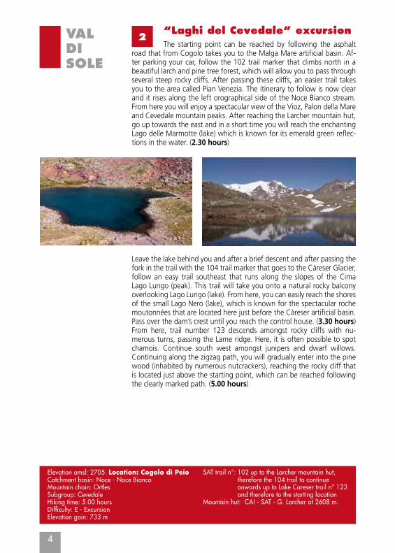
The starting point can be reached by following the asphalt road that from Cogolo takes you to the Malga Mare artificial basin. Af-ter parking your car, follow the 102 trail marker that climbs north in a beautiful larch and pine tree forest, which will allow you to pass through several steep rocky cliffs. After passing these cliffs, an easier trail takes you to the area called Pian Venezia. The itinerary to follow is now clear and it rises along the left orographical side of the Noce Bianco stream. From here you will enjoy a spectacular view of the Vioz, Palon della Mare and Cevedale mountain peaks. After reaching the Larcher mountain hut, go up towards the east and in a short time you will reach the enchanting Lago delle Marmotte (lake) which is known for its emerald green reflec-tions in the water. (2.30 hours)
Leave the lake behind you and after a brief descent and after passing the fork in the trail with the 104 trail marker that goes to the Càreser Glacier, follow an easy trail southeast that runs along the slopes of the Cima Lago Lungo (peak). This trail will take you onto a natural rocky balcony overlooking Lago Lungo (lake). From here, you can easily reach the shores of the small Lago Nero (lake), which is known for the spectacular roche moutonnées that are located here just before the Càreser artificial basin. Pass over the dam’s crest until you reach the control house. (3.30 hours)From here, trail number 123 descends amongst rocky cliffs with nu-merous turns, passing the Lame ridge. Here, it is often possible to spot chamois. Continue south west amongst junipers and dwarf willows. Continuing along the zigzag path, you will gradually enter into the pine wood (inhabited by numerous nutcrackers), reaching the rocky cliff that is located just above the starting point, which can be reached following the clearly marked path. (5.00 hours)
5
VALDISOLE
3Lago di Vallombrina (a 2-day excursion is recommended)
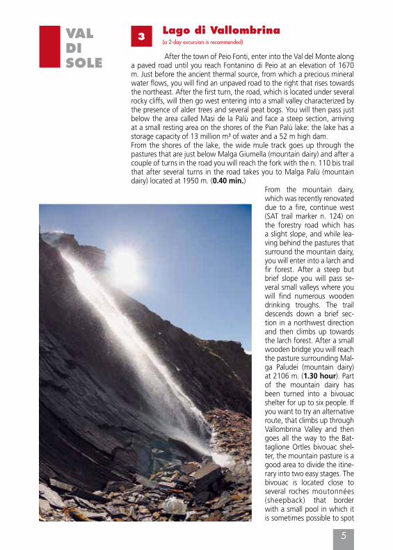
After the town of Peio Fonti, enter into the Val del Monte along a paved road until you reach Fontanino di Peio at an elevation of 1670 m. Just before the ancient thermal source, from which a precious mineral water flows, you will find an unpaved road to the right that rises towards the northeast. After the first turn, the road, which is located under several rocky cliffs, will then go west entering into a small valley characterized by the presence of alder trees and several peat bogs. You will then pass just below the area called Masi de la Palù and face a steep section, arriving at a small resting area on the shores of the Pian Palù lake: the lake has a storage capacity of 13 million m³ of water and a 52 m high dam.From the shores of the lake, the wide mule track goes up through the pastures that are just below Malga Giumella (mountain dairy) and after a couple of turns in the road you will reach the fork with the n. 110 bis trail that after several turns in the road takes you to Malga Palù (mountain dairy) located at 1950 m. (0.40 min.)
From the mountain dairy, which was recently renovated due to a fire, continue west (SAT trail marker n. 124) on the forestry road which has a slight slope, and while lea-ving behind the pastures that surround the mountain dairy, you will enter into a larch and fir forest. After a steep but brief slope you will pass se-veral small valleys where you will find numerous wooden drinking troughs. The trail descends down a brief sec-tion in a northwest direction and then climbs up towards the larch forest. After a small wooden bridge you will reach the pasture surrounding Mal-ga Paludei (mountain dairy) at 2106 m. (1.30 hour). Part of the mountain dairy has been turned into a bivouac shelter for up to six people. If you want to try an alternative route, that climbs up through Vallombrina Valley and then goes all the way to the Bat-taglione Ortles bivouac shel-ter, the mountain pasture is a good area to divide the itine-rary into two easy stages. The bivouac is located close to several roches moutonnées (sheepback) that border with a small pool in which it is sometimes possible to spot
6
VALDISOLE
VALL
OM
BRIN
A L
AKE
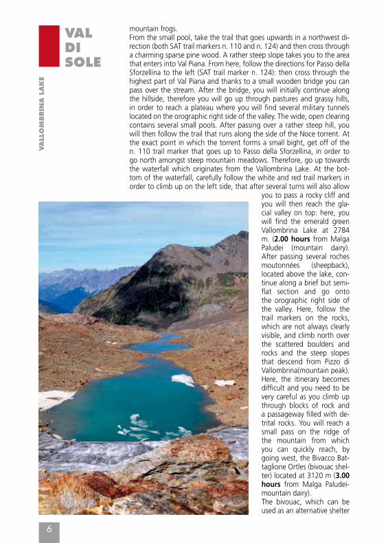
mountain frogs.From the small pool, take the trail that goes upwards in a northwest di-rection (both SAT trail markers n. 110 and n. 124) and then cross through a charming sparse pine wood. A rather steep slope takes you to the area that enters into Val Piana. From here, follow the directions for Passo della Sforzellina to the left (SAT trail marker n. 124): then cross through the highest part of Val Piana and thanks to a small wooden bridge you can pass over the stream. After the bridge, you will initially continue along the hillside, therefore you will go up through pastures and grassy hills, in order to reach a plateau where you will find several military tunnels located on the orographic right side of the valley. The wide, open clearing contains several small pools. After passing over a rather steep hill, you will then follow the trail that runs along the side of the Noce torrent. At the exact point in which the torrent forms a small bight, get off of the n. 110 trail marker that goes up to Passo della Sforzellina, in order to go north amongst steep mountain meadows. Therefore, go up towards the waterfall which originates from the Vallombrina Lake. At the bot-tom of the waterfall, carefully follow the white and red trail markers in order to climb up on the left side, that after several turns will also allow
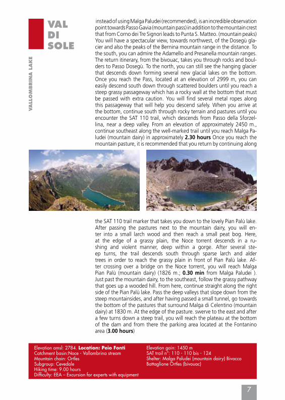
you to pass a rocky cliff and you will then reach the gla-cial valley on top: here, you will find the emerald green Vallombrina Lake at 2784 m. (2.00 hours from Malga Paludei (mountain dairy). After passing several roches moutonnées (sheepback), located above the lake, con-tinue along a brief but semi-flat section and go onto the orographic right side of the valley. Here, follow the trail markers on the rocks, which are not always clearly visible, and climb north over the scattered boulders and rocks and the steep slopes that descend from Pizzo di Vallombrina(mountain peak). Here, the itinerary becomes difficult and you need to be very careful as you climb up through blocks of rock and a passageway filled with de-trital rocks. You will reach a small pass on the ridge of the mountain from which you can quickly reach, by going west, the Bivacco Bat-taglione Ortles (bivouac shel-ter) located at 3120 m (3.00 hours from Malga Paludei-mountain dairy).The bivouac, which can be used as an alternative shelter
7
VALDISOLE
VALL
OM
BRIN
A L
AKE
Elevation amsl: 2784. Location: Peio FontiCatchment basin:Noce - Vallombrina streamMountain chain: OrtlesSubgroup: CevedaleHiking time: 9.00 hoursDifficulty: EEA – Excursion for experts with equipment
Elevation gain: 1450 mSAT trail n°: 110 - 110 bis - 124Shelter: Malga Paludei (mountain dairy) Bivacco Battaglione Ortles (bivouac)
instead of using Malga Paludei (recommended), is an incredible observation point towards Passo Gavia (mountain pass) in addition to the mountain crest that from Corno dei Tre Signori leads to Punta S. Matteo. (mountain peaks) You will have a spectacular view, towards northwest, of the Dosegù gla-cier and also the peaks of the Bernina mountain range in the distance. To the south, you can admire the Adamello and Presanella mountain ranges. The return itinerary, from the bivouac, takes you through rocks and boul-ders to Passo Dosegù. To the north, you can still see the hanging glacier that descends down forming several new glacial lakes on the bottom. Once you reach the Pass, located at an elevation of 2999 m, you can easily descend south down through scattered boulders until you reach a steep grassy passageway which has a rocky wall at the bottom that must be passed with extra caution. You will find several metal ropes along this passageway that will help you descend safely. When you arrive at the bottom, continue south through rocky terrain and pastures until you encounter the SAT 110 trail, which descends from Passo della Sforzel-lina, near a deep valley. From an elevation of approximately 2450 m., continue southeast along the well-marked trail until you reach Malga Pa-ludei (mountain dairy) in approximately 2.30 hours Once you reach the mountain pasture, it is recommended that you return by continuing along
the SAT 110 trail marker that takes you down to the lovely Pian Palù lake. After passing the pastures next to the mountain dairy, you will en-ter into a small larch wood and then reach a small peat bog. Here, at the edge of a grassy plain, the Noce torrent descends in a ru-shing and violent manner, deep within a gorge. After several ste-ep turns, the trail descends south through sparse larch and alder trees in order to reach the grassy plain in front of Pian Palù lake. Af-ter crossing over a bridge on the Noce torrent, you will reach Malga Pian Palù (mountain dairy) (1826 m.; 0.30 min from Malga Paludei ).Just past the mountain dairy, to the southeast, follow the grassy pathway that goes up a wooded hill. From here, continue straight along the right side of the Pian Palù lake. Pass the deep valleys that slope down from the steep mountainsides, and after having passed a small tunnel, go towards the bottom of the pastures that surround Malga di Celentino (mountain dairy) at 1830 m. At the edge of the pasture. swerve to the east and after a few turns down a steep trail, you will reach the plateau at the bottom of the dam and from there the parking area located at the Fontanino area (3.00 hours)
8
VALDISOLE
4I Laghi Corvo
Elevation amsl: 2462. Location: RabbiCatchment basin: Noce, Rabbies stream, Rio Val
Lago CorvoMountain chain: Ortles mountain groupSubgroup: Ortles
Climbing time: 3.00 hoursDifficulty: E – ExcursionElevation gain: 912 m up to Lake Corvo MaggioreSAT trail n°: CAI-SAT trail marker n. 108Mountain hut: Lago Corvo (private)
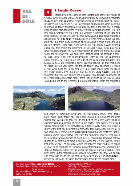
Starting from the parking area located just above the village of Cavallar in Val di Rabbi, you will begin your itinerary by following the forestry road and then onto a path that climbs up a steep slope which takes you throu-gh a larch forest. (CAI-SAT n. 108 trail marker). You will once again reach the forestry road, follow this road until you reach a fork in the road near a grassy clearing. From here, follow the well-marked trail towards northeast. Here, the trail becomes steeper as you climb up a wooded hill located at the edge of a large pasture. The trail will take you near the Malga Caldesa Bassa (mountain dairy) (1835 m., 1.00 hour), which has been recently renovated due to a fire.From the mountain dairy, continue onwards along a mule track until you reach a stream. From here, climb north until you reach a wide clearing above you that marks the beginning of Val Lago Corvo. After passing a small wooden bridge, you will initially begin to climb up along the small valley and therefore you will turn right (east) to climb up through a spar-se larch forest filled with rhododendrons. After passing the vegetation zone, continue to climb up on the side of the pasture located above the Malga Caldesa alta (mountain dairy). Leaving behind the trail that goes to Passo Palù on your right, the trail to follow now becomes less steep as you walk along the rocky base of Cima Quaira (peak) until you reach the rifugio Lago Corvo (mountain hut) (2425 m., 2.30 hours). From the mountain hut you can admire the extensive view towards southwest of the entire Brenta mountain range, from Mount Peller all the way to Cima Tosa (peak) and to the Crozzon di Brenta (mountain). From the mountain
hut, begin to climb northwest and you will quickly reach Passo Rabbi. From Passo Rabbi, follow the trail north, climbing up along the morainic terrace that will quickly take you to the first of the Corvo lakes, which is characterized by a barrage of rocks to the north. These lakes were formed within cirques that were excavated by a glacier. Walk along the western shore of the first lake and continue along the trail that will then take you to two small lakes; continue onwards by climbing up through scattered rubble, passing several small valleys that reach the snowline. You will then reach the next lake, at an elevation of 2623 meters, which has a long and narrow shape; if you continue to climb, a brief detour to the left will take you to the last of these lakes, called Terzo, which lies between rocks and fallen debris at 2655 m. To complete this itinerary in an interesting manner, climb up the slope of fallen rocks that lies just under the peak of Cima Collecchio. From here, climb up the mountain and follow the mountain ridge that will quickly and easily take you to the top of the peak located at 2957 m. (4.15 hours). Return by following the same itinerary back down to the parking area.
9
VALDISOLE
5Lago Rotondo and Lago Alto
Elevation amsl: 2574. Location: RabbiCatchment basin: Noce, Rabbies stream, Valorz streamMountain chain: OrtlesClimbing time: 4.30 hours to Passo Valletta, 7.30 to
the town of Ortisé
Difficulty: EE – Excursion for expertsElevation gain: 1449 m (up to Passo Valletta)SAT trail n°: CAI-SAT trail marker n. 121 – 121AShelter: Bicacco Malga di Soprasasso (bivouac) Malga Bronzolo (mountain dairy)
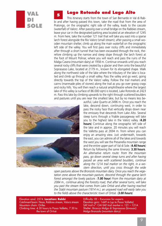
This itinerary starts from the town of San Bernardo in Val di Rab-bi and after having passed this town, take the road that from the area of Pralongo, on the orographic right side of the valley, leads to the cascate (waterfall) of Valorz. After passing over a small bridge on the Rabbies stream, leave your car in the designated parking area located at an elevation of 1245 m. From here, take the number 121 trail that will take you east into a sparse larch forest alongside the Rio Valorz (small stream); after passing a small wo-oden mountain shelter, climb up along the main waterfall on the orographic left side of the valley. You will first pass over rocky cliffs and immediately after through a short tunnel that has been excavated through the rock, the-refore climbing up the narrow and steep slope through the larch forest at the foot of Mount Polinar, where you will reach and pass the ruins of the Malga Casera (mountain dairy) at 1958 m. Continue onwards until you reach several rocky cliffs that were created by a glacier and then onto the beautiful Soprasasso Lake, located at 2179 m., known for its elongated shape. Walk along the northwest side of the lake where the tributary of the lake is loca-ted and climb up through a small valley. Pass the valley and go west, going directly towards the top of the Valorz valley. Follow the trail markers and cairns (manmade piles of stones) along the trail as you go over grassy crags and rocky hills. You will then reach a natural amphitheatre where the largest lake of this valley (a surface of 86.000 sqm) is located, Lake Rotondo at 2423 m. Pass this lake by climbing upwards to the right through scattered boulders and pastures until you are near the smallest lake, but by no means less be-
autiful, Lake Quarto at 2496 m. Once you reach the lake, descend down, continuing west, in order to pass the rocky face that vertically drops down near the emissary that descends from Lake Alto. Several steep turns through a friable passageway will take you to the highest lake in the Valorz valley. (4.20 hours) Continue along the orographic left side of the lake and in approx. 20 minutes you will reach the Valletta pass at 2694 m. from where you can enjoy an amazing view. Just underneath, towards the east, you can admire all of the lakes and towards the west you will see the Presanella mountain range and the entire upper part of Val di Sole. (4.40 hours)Return by following the same itinerary: 3.30 hours.An alternative return route: from the mountain pass, go down several steep turns and after having passed an area with scattered boulders, continue along the 121A trail marker on the right, in a we-stern direction, until you cross through the wide
open pastures above the Bronzolo mountain dairy. Once you reach the vege-tation zone above the mountain pasture, descend through the sparse larch forest amongst the lovely pasture. (1.00 hour) From the mountain dairy at 2084 m., continue along the forestry road, that after several turns, will take you past the stream that comes from Lake Ortisè and after having reached the Stabli mountain pasture (1814 m.), an unpaved road will easily take you to the fields above the characteristic town of Ortisè. (3.00 hours)
10
VALDISOLE
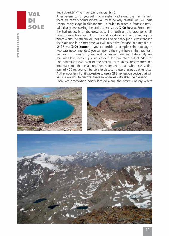
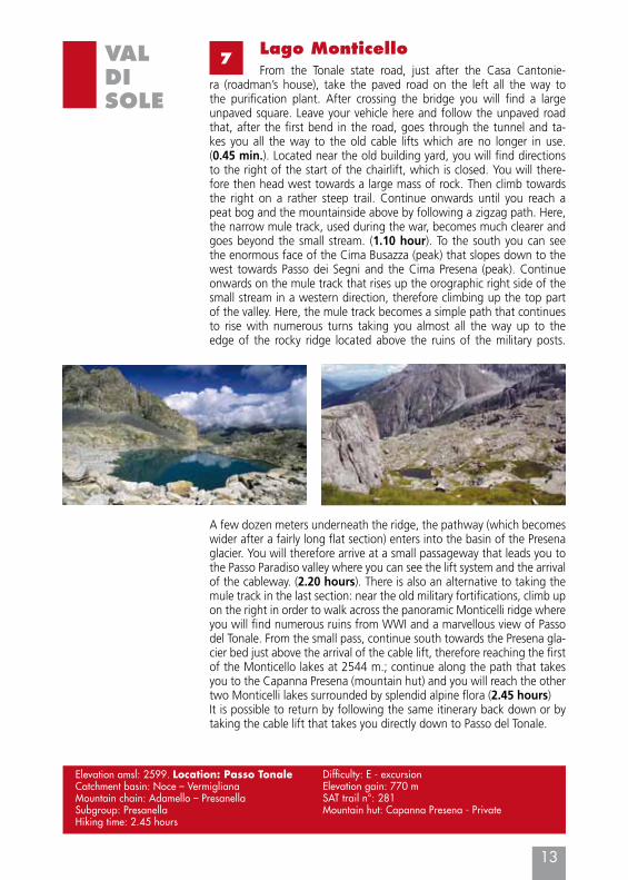
6Laghi Sternai (a 2-day itinerary is recommended)
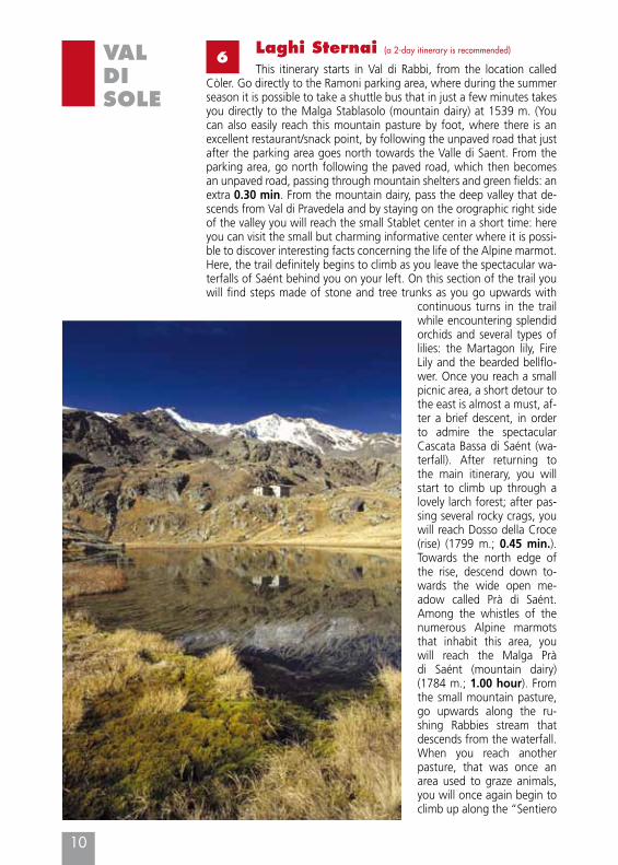
This itinerary starts in Val di Rabbi, from the location called Còler. Go directly to the Ramoni parking area, where during the summer season it is possible to take a shuttle bus that in just a few minutes takes you directly to the Malga Stablasolo (mountain dairy) at 1539 m. (You can also easily reach this mountain pasture by foot, where there is an excellent restaurant/snack point, by following the unpaved road that just after the parking area goes north towards the Valle di Saent. From the parking area, go north following the paved road, which then becomes an unpaved road, passing through mountain shelters and green fields: an extra 0.30 min. From the mountain dairy, pass the deep valley that de-scends from Val di Pravedela and by staying on the orographic right side of the valley you will reach the small Stablet center in a short time: here you can visit the small but charming informative center where it is possi-ble to discover interesting facts concerning the life of the Alpine marmot. Here, the trail definitely begins to climb as you leave the spectacular wa-terfalls of Saént behind you on your left. On this section of the trail you will find steps made of stone and tree trunks as you go upwards with
continuous turns in the trail while encountering splendid orchids and several types of lilies: the Martagon lily, Fire Lily and the bearded bellflo-wer. Once you reach a small picnic area, a short detour to the east is almost a must, af-ter a brief descent, in order to admire the spectacular Cascata Bassa di Saént (wa-terfall). After returning to the main itinerary, you will start to climb up through a lovely larch forest; after pas-sing several rocky crags, you will reach Dosso della Croce (rise) (1799 m.; 0.45 min.). Towards the north edge of the rise, descend down to-wards the wide open me-adow called Prà di Saént. Among the whistles of the numerous Alpine marmots that inhabit this area, you will reach the Malga Prà di Saént (mountain dairy) (1784 m.; 1.00 hour). From the small mountain pasture, go upwards along the ru-shing Rabbies stream that descends from the waterfall. When you reach another pasture, that was once an area used to graze animals, you will once again begin to climb up along the “Sentiero
11
VALDISOLE
STE
RN
AI LA
KES
degli alpinisti” (The mountain climbers’ trail).After several turns, you will find a metal cord along the trail. In fact, there are certain points where you must be very careful. You will pass several rocky crags in this manner in order to reach a fantastic natu-ral balcony overlooking the entire Saent valley (2.00 hours). From here, the trail gradually climbs upwards to the north on the orographic left side of the valley among blossoming rhododendrons. By continuing up-wards along the stream you will reach a wide peaty plain, cross through the plain and in a short time you will reach the Dorigoni mountain hut. (2437 m.; (3.00 hours). If you do decide to complete the itinerary in two days (recommended) you can spend the night here at the mountain hut, which is very cozy and well organized. You must definitely see the small lake located just underneath the mountain hut at 2410 m. The naturalistic excursion of the Sternai lakes starts directly from the mountain hut, that in approx. two hours and a half with an elevation gain of 400 m, you will be able to discover these precious alpine lakes. At the mountain hut it is possible to use a GPS navigation device that will easily allow you to discover these seven lakes with absolute precision. There are observation points located along the entire itinerary where
12
VALDISOLE
STE
RN
AI LA
KES
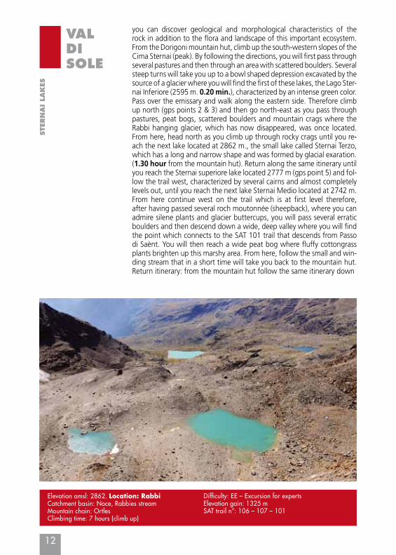
you can discover geological and morphological characteristics of the rock in addition to the flora and landscape of this important ecosystem. From the Dorigoni mountain hut, climb up the south-western slopes of the Cima Sternai (peak). By following the directions, you will first pass through several pastures and then through an area with scattered boulders. Several steep turns will take you up to a bowl shaped depression excavated by the source of a glacier where you will find the first of these lakes, the Lago Ster-nai Inferiore (2595 m. 0.20 min.), characterized by an intense green color.Pass over the emissary and walk along the eastern side. Therefore climb up north (gps points 2 & 3) and then go north-east as you pass through pastures, peat bogs, scattered boulders and mountain crags where the Rabbi hanging glacier, which has now disappeared, was once located. From here, head north as you climb up through rocky crags until you re-ach the next lake located at 2862 m., the small lake called Sternai Terzo, which has a long and narrow shape and was formed by glacial exaration.(1.30 hour from the mountain hut). Return along the same itinerary until you reach the Sternai superiore lake located 2777 m (gps point 5) and fol-low the trail west, characterized by several cairns and almost completely levels out, until you reach the next lake Sternai Medio located at 2742 m. From here continue west on the trail which is at first level therefore, after having passed several roch moutonnée (sheepback), where you can admire silene plants and glacier buttercups, you will pass several erratic boulders and then descend down a wide, deep valley where you will find the point which connects to the SAT 101 trail that descends from Passo di Saènt. You will then reach a wide peat bog where fluffy cottongrass plants brighten up this marshy area. From here, follow the small and win-ding stream that in a short time will take you back to the mountain hut. Return itinerary: from the mountain hut follow the same itinerary down
Elevation amsl: 2862. Location: RabbiCatchment basin: Noce, Rabbies streamMountain chain: OrtlesClimbing time: 7 hours (climb up)
Difficulty: EE – Excursion for expertsElevation gain: 1325 mSAT trail n°: 106 – 107 – 101
13
VALDISOLE
7Lago Monticello
Elevation amsl: 2599. Location: Passo TonaleCatchment basin: Noce – Vermigliana Mountain chain: Adamello – PresanellaSubgroup: PresanellaHiking time: 2.45 hours
Difficulty: E - excursionElevation gain: 770 mSAT trail n°: 281 Mountain hut: Capanna Presena - Private
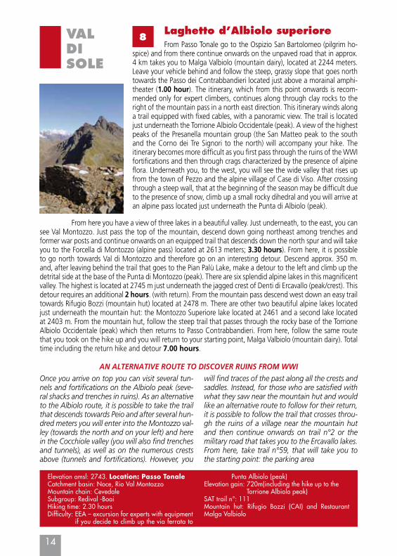
From the Tonale state road, just after the Casa Cantonie-ra (roadman’s house), take the paved road on the left all the way to the purification plant. After crossing the bridge you will find a large unpaved square. Leave your vehicle here and follow the unpaved road that, after the first bend in the road, goes through the tunnel and ta-kes you all the way to the old cable lifts which are no longer in use. (0.45 min.). Located near the old building yard, you will find directions to the right of the start of the chairlift, which is closed. You will there-fore then head west towards a large mass of rock. Then climb towards the right on a rather steep trail. Continue onwards until you reach a peat bog and the mountainside above by following a zigzag path. Here, the narrow mule track, used during the war, becomes much clearer and goes beyond the small stream. (1.10 hour). To the south you can see the enormous face of the Cima Busazza (peak) that slopes down to the west towards Passo dei Segni and the Cima Presena (peak). Continue onwards on the mule track that rises up the orographic right side of the small stream in a western direction, therefore climbing up the top part of the valley. Here, the mule track becomes a simple path that continues to rise with numerous turns taking you almost all the way up to the edge of the rocky ridge located above the ruins of the military posts.
A few dozen meters underneath the ridge, the pathway (which becomes wider after a fairly long flat section) enters into the basin of the Presena glacier. You will therefore arrive at a small passageway that leads you to the Passo Paradiso valley where you can see the lift system and the arrival of the cableway. (2.20 hours). There is also an alternative to taking the mule track in the last section: near the old military fortifications, climb up on the right in order to walk across the panoramic Monticelli ridge where you will find numerous ruins from WWI and a marvellous view of Passo del Tonale. From the small pass, continue south towards the Presena gla-cier bed just above the arrival of the cable lift, therefore reaching the first of the Monticello lakes at 2544 m.; continue along the path that takes you to the Capanna Presena (mountain hut) and you will reach the other two Monticelli lakes surrounded by splendid alpine flora (2.45 hours)It is possible to return by following the same itinerary back down or by taking the cable lift that takes you directly down to Passo del Tonale.
14
VALDISOLE
8Laghetto d’Albiolo superiore
Elevation amsl: 2743. Location: Passo TonaleCatchment basin: Noce, Rio Val MontozzoMountain chain: CevedaleSubgroup: Redival -BoaiHiking time: 2.30 hoursDifficulty: EEA – excursion for experts with equipment
if you decide to climb up the via ferrata to
Punta Albiolo (peak)Elevation gain: 720m(including the hike up to the
Torrione Albiolo peak)SAT trail n°: 111Mountain hut: Rifugio Bozzi (CAI) and Restaurant Malga Valbiolo
From Passo Tonale go to the Ospizio San Bartolomeo (pilgrim ho-spice) and from there continue onwards on the unpaved road that in approx. 4 km takes you to Malga Valbiolo (mountain dairy), located at 2244 meters. Leave your vehicle behind and follow the steep, grassy slope that goes north towards the Passo dei Contrabbandieri located just above a morainal amphi-theater (1.00 hour). The itinerary, which from this point onwards is recom-mended only for expert climbers, continues along through clay rocks to the right of the mountain pass in a north east direction. This itinerary winds along a trail equipped with fixed cables, with a panoramic view. The trail is located just underneath the Torrione Albiolo Occidentale (peak). A view of the highest peaks of the Presanella mountain group (the San Matteo peak to the south and the Corno dei Tre Signori to the north) will accompany your hike. The itinerary becomes more difficult as you first pass through the ruins of the WWI fortifications and then through crags characterized by the presence of alpine flora. Underneath you, to the west, you will see the wide valley that rises up from the town of Pezzo and the alpine village of Case di Viso. After crossing through a steep wall, that at the beginning of the season may be difficult due to the presence of snow, climb up a small rocky dihedral and you will arrive at an alpine pass located just underneath the Punta di Albiolo (peak).
Once you arrive on top you can visit several tun-nels and fortifications on the Albiolo peak (seve-ral shacks and trenches in ruins). As an alternative to the Albiolo route, it is possible to take the trail that descends towards Peio and after several hun-dred meters you will enter into the Montozzo val-ley (towards the north and on your left) and here in the Cocchiole valley (you will also find trenches and tunnels), as well as on the numerous crests above (tunnels and fortifications). However, you
will find traces of the past along all the crests and saddles. Instead, for those who are satisfied with what they saw near the mountain hut and would like an alternative route to follow for their return, it is possible to follow the trail that crosses throu-gh the ruins of a village near the mountain hut and then continue onwards on trail n°2 or the military road that takes you to the Ercavallo lakes. From here, take trail n°59, that will take you to the starting point: the parking area
AN ALTERNATIVE ROUTE TO DISCOVER RUINS FROM WWI
From here you have a view of three lakes in a beautiful valley. Just underneath, to the east, you can see Val Montozzo. Just pass the top of the mountain, descend down going northeast among trenches and former war posts and continue onwards on an equipped trail that descends down the north spur and will take you to the Forcella di Montozzo (alpine pass) located at 2613 meters; 3.30 hours). From here, it is possible to go north towards Val di Montozzo and therefore go on an interesting detour. Descend approx. 350 m. and, after leaving behind the trail that goes to the Pian Palù Lake, make a detour to the left and climb up the detrital side at the base of the Punta di Montozzo (peak). There are six splendid alpine lakes in this magnificent valley. The highest is located at 2745 m just underneath the jagged crest of Denti di Ercavallo (peak/crest). This detour requires an additional 2 hours. (with return). From the mountain pass descend west down an easy trail towards Rifugio Bozzi (mountain hut) located at 2478 m. There are other two beautiful alpine lakes located just underneath the mountain hut: the Montozzo Superiore lake located at 2461 and a second lake located at 2403 m. From the mountain hut, follow the steep trail that passes through the rocky base of the Torrione Albiolo Occidentale (peak) which then returns to Passo Contrabbandieri. From here, follow the same route that you took on the hike up and you will return to your starting point, Malga Valbiolo (mountain dairy). Total time including the return hike and detour 7.00 hours.
15
VALDISOLE
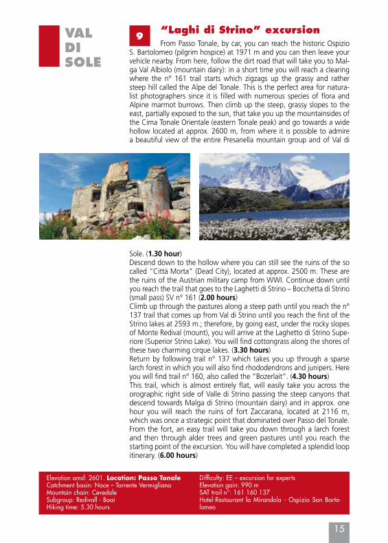
9“Laghi di Strino” excursionFrom Passo Tonale, by car, you can reach the historic Ospizio
S. Bartolomeo (pilgrim hospice) at 1971 m and you can then leave your vehicle nearby. From here, follow the dirt road that will take you to Mal-ga Val Albiolo (mountain dairy): in a short time you will reach a clearing where the n° 161 trail starts which zigzags up the grassy and rather steep hill called the Alpe del Tonale. This is the perfect area for natura-list photographers since it is filled with numerous species of flora and Alpine marmot burrows. Then climb up the steep, grassy slopes to the east, partially exposed to the sun, that take you up the mountainsides of the Cima Tonale Orientale (eastern Tonale peak) and go towards a wide hollow located at approx. 2600 m, from where it is possible to admire a beautiful view of the entire Presanella mountain group and of Val di
Sole. (1.30 hour)Descend down to the hollow where you can still see the ruins of the so called “Città Morta” (Dead City), located at approx. 2500 m. These are the ruins of the Austrian military camp from WWI. Continue down until you reach the trail that goes to the Laghetti di Strino – Bocchetta di Strino (small pass) SV n° 161 (2.00 hours)Climb up through the pastures along a steep path until you reach the n° 137 trail that comes up from Val di Strino until you reach the first of the Strino lakes at 2593 m.; therefore, by going east, under the rocky slopes of Monte Redival (mount), you will arrive at the Laghetto di Strino Supe-riore (Superior Strino Lake). You will find cottongrass along the shores of these two charming cirque lakes. (3.30 hours)Return by following trail n° 137 which takes you up through a sparse larch forest in which you will also find rhododendrons and junipers. Here you will find trail n° 160, also called the “Bozerlait”. (4.30 hours)This trail, which is almost entirely flat, will easily take you across the orographic right side of Valle di Strino passing the steep canyons that descend towards Malga di Strino (mountain dairy) and in approx. one hour you will reach the ruins of fort Zaccarana, located at 2116 m, which was once a strategic point that dominated over Passo del Tonale. From the fort, an easy trail will take you down through a larch forest and then through alder trees and green pastures until you reach the starting point of the excursion. You will have completed a splendid loop itinerary. (6.00 hours)
Elevation amsl: 2601. Location: Passo TonaleCatchment basin: Noce – Torrente VermiglianaMountain chain: CevedaleSubgroup: Redivall - Boai Hiking time: 5.30 hours
Difficulty: EE – excursion for expertsElevation gain: 990 mSAT trail n°: 161 160 137Hotel-Restaurant la Mirandola - Ospizio San Barto-lomeo
16
VALDISOLE
10Lago Denza
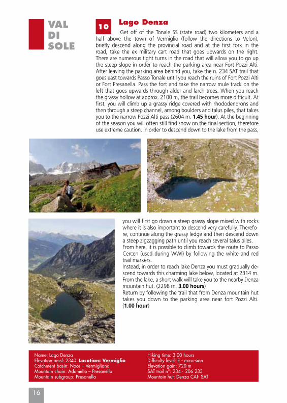
Get off of the Tonale SS (state road) two kilometers and a half above the town of Vermiglio (follow the directions to Velon), briefly descend along the provincial road and at the first fork in the road, take the ex military cart road that goes upwards on the right. There are numerous tight turns in the road that will allow you to go up the steep slope in order to reach the parking area near Fort Pozzi Alti. After leaving the parking area behind you, take the n. 234 SAT trail that goes east towards Passo Tonale until you reach the ruins of Fort Pozzi Alti or Fort Presanella. Pass the fort and take the narrow mule track on the left that goes upwards through alder and larch trees. When you reach the grassy hollow at approx. 2100 m, the trail becomes more difficult. At first, you will climb up a grassy ridge covered with rhododendrons and then through a steep channel, among boulders and talus piles, that takes you to the narrow Pozzi Alti pass (2604 m. 1.45 hour). At the beginning of the season you will often still find snow on the final section, therefore use extreme caution. In order to descend down to the lake from the pass,
you will first go down a steep grassy slope mixed with rocks where it is also important to descend very carefully. Therefo-re, continue along the grassy ledge and then descend down a steep zigzagging path until you reach several talus piles.From here, it is possible to climb towards the route to Passo Cercen (used during WWI) by following the white and red trail markers.Instead, in order to reach lake Denza you must gradually de-scend towards this charming lake below, located at 2314 m. From the lake, a short walk will take you to the nearby Denza mountain hut. (2298 m. 3.00 hours)Return by following the trail that from Denza mountain hut takes you down to the parking area near fort Pozzi Alti. (1.00 hour)
Name: Lago DenzaElevation amsl: 2340. Location: VermiglioCatchment basin: Noce – Vermigliana Mountain chain: Adamello – PresanellaMountain subgroup: Presanella
Hiking time: 3.00 hoursDifficulty level: E - excursionElevation gain: 720 mSAT trail n°: 234 - 206 233Mountain hut: Denza CAI- SAT
17
VALDISOLE
11Lago Barco and Lago PiccoloYou can reach the beginning of this itinerary by car. From the
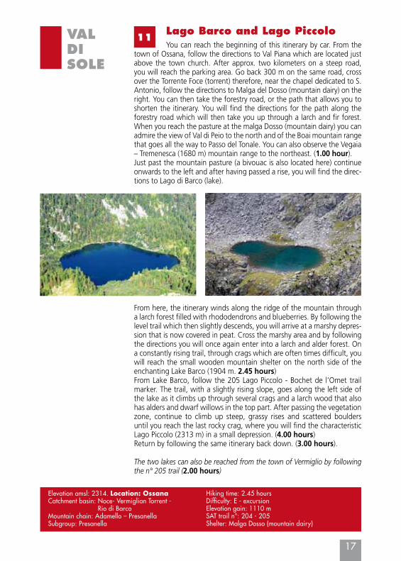
town of Ossana, follow the directions to Val Piana which are located just above the town church. After approx. two kilometers on a steep road, you will reach the parking area. Go back 300 m on the same road, cross over the Torrente Foce (torrent) therefore, near the chapel dedicated to S. Antonio, follow the directions to Malga del Dosso (mountain dairy) on the right. You can then take the forestry road, or the path that allows you to shorten the itinerary. You will find the directions for the path along the forestry road which will then take you up through a larch and fir forest. When you reach the pasture at the malga Dosso (mountain dairy) you can admire the view of Val di Peio to the north and of the Boai mountain range that goes all the way to Passo del Tonale. You can also observe the Vegaia – Tremenesca (1680 m) mountain range to the northeast. (1.00 hour).Just past the mountain pasture (a bivouac is also located here) continue onwards to the left and after having passed a rise, you will find the direc-tions to Lago di Barco (lake).
From here, the itinerary winds along the ridge of the mountain through a larch forest filled with rhododendrons and blueberries. By following the level trail which then slightly descends, you will arrive at a marshy depres-sion that is now covered in peat. Cross the marshy area and by following the directions you will once again enter into a larch and alder forest. On a constantly rising trail, through crags which are often times difficult, you will reach the small wooden mountain shelter on the north side of the enchanting Lake Barco (1904 m. 2.45 hours)From Lake Barco, follow the 205 Lago Piccolo - Bochet de l’Omet trail marker. The trail, with a slightly rising slope, goes along the left side of the lake as it climbs up through several crags and a larch wood that also has alders and dwarf willows in the top part. After passing the vegetation zone, continue to climb up steep, grassy rises and scattered boulders until you reach the last rocky crag, where you will find the characteristic Lago Piccolo (2313 m) in a small depression. (4.00 hours)Return by following the same itinerary back down. (3.00 hours).
The two lakes can also be reached from the town of Vermiglio by following the n° 205 trail (2.00 hours)
Elevation amsl: 2314. Location: OssanaCatchment basin: Noce- Vermiglian Torrent -
Rio di Barco Mountain chain: Adamello – PresanellaSubgroup: Presanella
Hiking time: 2.45 hoursDifficulty: E - excursionElevation gain: 1110 mSAT trail n°: 204 - 205Shelter: Malga Dosso (mountain dairy)
18
VALDISOLE
12Lago Stablo and Lago FazzonFrom Pellizzano take the road that goes to the plain of Fazzon and
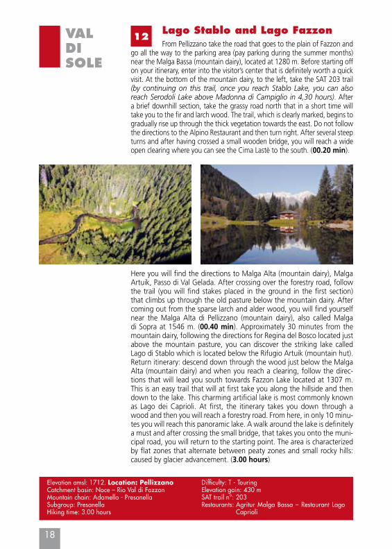
go all the way to the parking area (pay parking during the summer months) near the Malga Bassa (mountain dairy), located at 1280 m. Before starting off on your itinerary, enter into the visitor’s center that is definitely worth a quick visit. At the bottom of the mountain dairy, to the left, take the SAT 203 trail (by continuing on this trail, once you reach Stablo Lake, you can also reach Serodoli Lake above Madonna di Campiglio in 4,30 hours). After a brief downhill section, take the grassy road north that in a short time will take you to the fir and larch wood. The trail, which is clearly marked, begins to gradually rise up through the thick vegetation towards the east. Do not follow the directions to the Alpino Restaurant and then turn right. After several steep turns and after having crossed a small wooden bridge, you will reach a wide open clearing where you can see the Cima Lastè to the south. (00.20 min).
Here you will find the directions to Malga Alta (mountain dairy), Malga Artuik, Passo di Val Gelada. After crossing over the forestry road, follow the trail (you will find stakes placed in the ground in the first section) that climbs up through the old pasture below the mountain dairy. After coming out from the sparse larch and alder wood, you will find yourself near the Malga Alta di Pellizzano (mountain dairy), also called Malga di Sopra at 1546 m. (00.40 min). Approximately 30 minutes from the mountain dairy, following the directions for Regina del Bosco located just above the mountain pasture, you can discover the striking lake called Lago di Stablo which is located below the Rifugio Artuik (mountain hut). Return itinerary: descend down through the wood just below the Malga Alta (mountain dairy) and when you reach a clearing, follow the direc-tions that will lead you south towards Fazzon Lake located at 1307 m. This is an easy trail that will at first take you along the hillside and then down to the lake. This charming artificial lake is most commonly known as Lago dei Caprioli. At first, the itinerary takes you down through a wood and then you will reach a forestry road. From here, in only 10 minu-tes you will reach this panoramic lake. A walk around the lake is definitely a must and after crossing the small bridge, that takes you onto the muni-cipal road, you will return to the starting point. The area is characterized by flat zones that alternate between peaty zones and small rocky hills: caused by glacier advancement. (3.00 hours)
Elevation amsl: 1712. Location: PellizzanoCatchment basin: Noce – Rio Val di Fazzon Mountain chain: Adamello - PresanellaSubgroup: PresanellaHiking time: 3.00 hours
Difficulty: T - TouringElevation gain: 430 mSAT trail n°: 203Restaurants: Agritur Malga Bassa – Restaurant Lago
Caprioli
19
VALDISOLE
13Laghi del Malghetto di Mezzana superiore
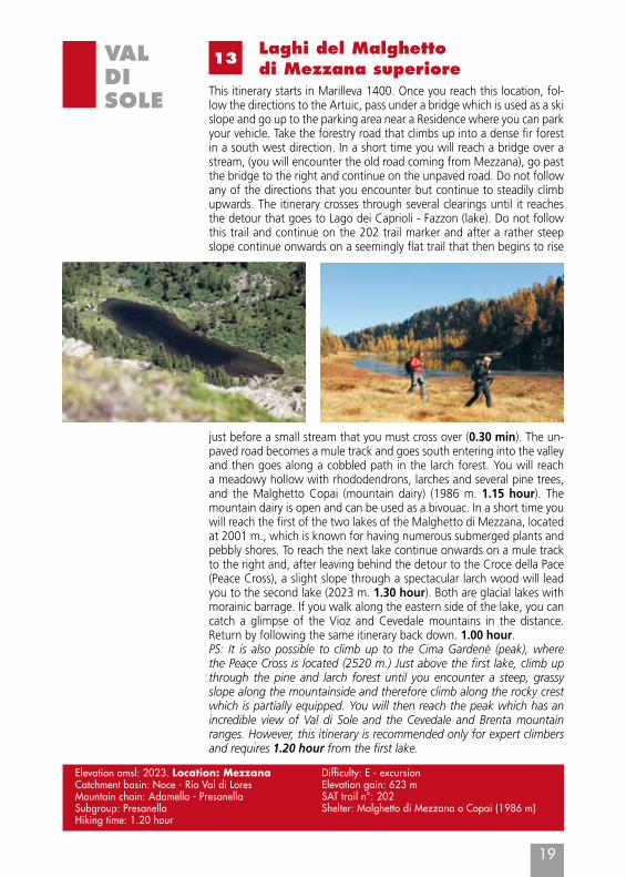
This itinerary starts in Marilleva 1400. Once you reach this location, fol-low the directions to the Artuic, pass under a bridge which is used as a ski slope and go up to the parking area near a Residence where you can park your vehicle. Take the forestry road that climbs up into a dense fir forest in a south west direction. In a short time you will reach a bridge over a stream, (you will encounter the old road coming from Mezzana), go past the bridge to the right and continue on the unpaved road. Do not follow any of the directions that you encounter but continue to steadily climb upwards. The itinerary crosses through several clearings until it reaches the detour that goes to Lago dei Caprioli - Fazzon (lake). Do not follow this trail and continue on the 202 trail marker and after a rather steep slope continue onwards on a seemingly flat trail that then begins to rise
Elevation amsl: 2023. Location: MezzanaCatchment basin: Noce - Rio Val di Lores Mountain chain: Adamello - PresanellaSubgroup: PresanellaHiking time: 1.20 hour
Difficulty: E - excursionElevation gain: 623 mSAT trail n°: 202Shelter: Malghetto di Mezzana o Copai (1986 m)
just before a small stream that you must cross over (0.30 min). The un-paved road becomes a mule track and goes south entering into the valley and then goes along a cobbled path in the larch forest. You will reach a meadowy hollow with rhododendrons, larches and several pine trees, and the Malghetto Copai (mountain dairy) (1986 m. 1.15 hour). The mountain dairy is open and can be used as a bivouac. In a short time you will reach the first of the two lakes of the Malghetto di Mezzana, located at 2001 m., which is known for having numerous submerged plants and pebbly shores. To reach the next lake continue onwards on a mule track to the right and, after leaving behind the detour to the Croce della Pace (Peace Cross), a slight slope through a spectacular larch wood will lead you to the second lake (2023 m. 1.30 hour). Both are glacial lakes with morainic barrage. If you walk along the eastern side of the lake, you can catch a glimpse of the Vioz and Cevedale mountains in the distance. Return by following the same itinerary back down. 1.00 hour.PS: It is also possible to climb up to the Cima Gardenè (peak), where the Peace Cross is located (2520 m.) Just above the first lake, climb up through the pine and larch forest until you encounter a steep, grassy slope along the mountainside and therefore climb along the rocky crest which is partially equipped. You will then reach the peak which has an incredible view of Val di Sole and the Cevedale and Brenta mountain ranges. However, this itinerary is recommended only for expert climbers and requires 1.20 hour from the first lake.
20
VALDISOLE
14Lago Malghette
Leave your vehicle near the area next to the Rio Falzè residence. Just before Passo Campo Carlo Magno, follow the wide, semi-level fore-stry road to the right that will take you into a charming fir forest to the north. After passing through a small peat bog (Palù della Fava), cross over the Meledrio torrent on a small wooden bridge and con-tinue upwards on the unpaved road until you reach a wide clearing where you will find the Malga Vigo (mountain dairy) on the right. From here there is a beautiful view of the peaks of the northern part of the Brenta mountain range. Just underneath you can see the ski lifts, which during the winter season, go right up to Rifugio Orso Bruno (mountain hut).
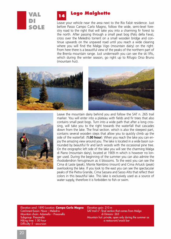
Leave the mountain dairy behind you and follow the SAT n. 265 trail marker. You will enter into a plateau with fields and fir trees that also contains small peat bogs. Turn into a wide path that after a long cros-sing, will take you to the right towards the waterfall that cascades down from the lake. The final section. which is also the steepest part, contains several wooden steps that allow you to quickly climb up the side of the waterfall. (1.00 hour). When you reach the lake you can en-joy the amazing view around you. The lake is located in a wide basin sur-rounded by beautiful fir and larch woods with the occasional pine tree. On the orographic left side of the lake you will see the charming Malga di Piano (mountain dairy), located at 1909 m which is however no lon-ger used. During the beginning of the summer you can also admire the rhododendron ferrugineum as it blossoms. To the west you can see the Cima di Laste (peak), Monte Nambino (mount) and Cima Artuick (peak) overlooking the lake. If you look to the east you can see the spectacular peaks of the Pietra Grande, Cima Sassara and Sasso Alto that reflect their colors in this beautiful lake. This lake is exclusively used as a source of water supply, therefore it is forbidden to fish or swim.
Elevation amsl: 1890 Location: Campo Carlo MagnoCatchment basin: Noce – Meledrio Mountain chain: Adamello – PresanellaSubgroup: PresanellaHiking time: 1.00 hourDifficulty: E - excursion
Elevation gain: 210 mSAT trail n°: final section that comes from Malga
di Dimaro- 265Mountain hut: private, open only during the summer as
a restaurant/snack bar
VALDISOLE
21
15I Tre Laghi
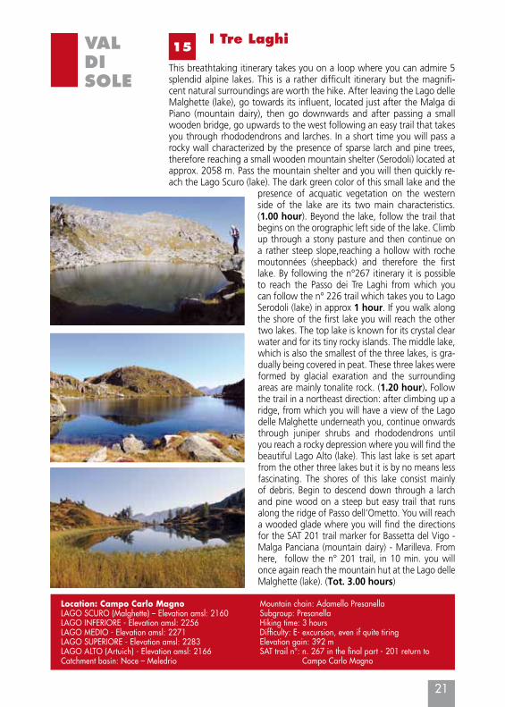
This breathtaking itinerary takes you on a loop where you can admire 5 splendid alpine lakes. This is a rather difficult itinerary but the magnifi-cent natural surroundings are worth the hike. After leaving the Lago delle Malghette (lake), go towards its influent, located just after the Malga di Piano (mountain dairy), then go downwards and after passing a small wooden bridge, go upwards to the west following an easy trail that takes you through rhododendrons and larches. In a short time you will pass a rocky wall characterized by the presence of sparse larch and pine trees, therefore reaching a small wooden mountain shelter (Serodoli) located at approx. 2058 m. Pass the mountain shelter and you will then quickly re-ach the Lago Scuro (lake). The dark green color of this small lake and the
presence of acquatic vegetation on the western side of the lake are its two main characteristics. (1.00 hour). Beyond the lake, follow the trail that begins on the orographic left side of the lake. Climb up through a stony pasture and then continue on a rather steep slope,reaching a hollow with roche moutonnées (sheepback) and therefore the first lake. By following the n°267 itinerary it is possible to reach the Passo dei Tre Laghi from which you can follow the n° 226 trail which takes you to Lago Serodoli (lake) in approx 1 hour. If you walk along the shore of the first lake you will reach the other two lakes. The top lake is known for its crystal clear water and for its tiny rocky islands. The middle lake, which is also the smallest of the three lakes, is gra-dually being covered in peat. These three lakes were formed by glacial exaration and the surrounding areas are mainly tonalite rock. (1.20 hour). Follow the trail in a northeast direction: after climbing up a ridge, from which you will have a view of the Lago delle Malghette underneath you, continue onwards through juniper shrubs and rhododendrons until you reach a rocky depression where you will find the beautiful Lago Alto (lake). This last lake is set apart from the other three lakes but it is by no means less fascinating. The shores of this lake consist mainly of debris. Begin to descend down through a larch and pine wood on a steep but easy trail that runs along the ridge of Passo dell’Ometto. You will reach a wooded glade where you will find the directions for the SAT 201 trail marker for Bassetta del Vigo - Malga Panciana (mountain dairy) - Marilleva. From here, follow the n° 201 trail, in 10 min. you will once again reach the mountain hut at the Lago delle Malghette (lake). (Tot. 3.00 hours)
Location: Campo Carlo MagnoLAGO SCURO (Malghette) – Elevation amsl: 2160LAGO INFERIORE - Elevation amsl: 2256LAGO MEDIO - Elevation amsl: 2271LAGO SUPERIORE - Elevation amsl: 2283LAGO ALTO (Artuich) - Elevation amsl: 2166 Catchment basin: Noce – Meledrio
Mountain chain: Adamello PresanellaSubgroup: PresanellaHiking time: 3 hours Difficulty: E- excursion, even if quite tiringElevation gain: 392 mSAT trail n°: n. 267 in the final part - 201 return to
Campo Carlo Magno
22
VALDISOLE
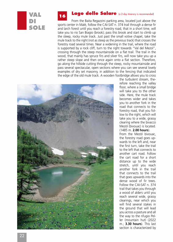
16Lago delle Salare (a 2-day itinerary is recommended)
From the Baita Regazzini parking area, located just above the sports center in Malé, follow the CAI-SAT n. 374 trail through a dense fir and larch forest until you reach a forestry road, that in a short time, will take you to rio San Biagio (brook); pass this brook and start to climb up the steep, rocky mule track. Just past the small votive chapel, take the mule track to the right (not as steep as the previous track) that crosses the forestry road several times. Near a widening in the trail, where the road is supported by a rock cliff, turn to the right towards “Val del Mezol”, crossing through the steep mountainside on a flat trail. The trail in the wood, that mainly has spruce firs and silver firs, will now take you up a rather steep slope and then once again onto a flat section. Therefore, go along the hillside cutting through the steep, rocky mountainside and pass several spectacular, open sections where you can see several lovely examples of dry set masonry, in addition to the fencing that indicated the edge of the old mule track. A wooden footbridge allows you to cross
the turbulent stream, the-refore reaching the valley floor, where a small bridge will take you to the other side. Here, the mule track becomes wider and takes you to another fork in the road that connects to the forestry road, that you fol-low to the right, which will take you to a wide, grassy clearing where the bivacco Mezòl (bivouac) is located. (1485 m. 2.00 hours). From the Mezòl bivouac, the forestry road goes up-wards to the left and, near the first turn, take the trail to the left that connects to another cart road. Follow the cart road for a short distance up to the wide stretch, until you reach another fork in the trail that connects to the trail that goes upwards into the dense wood of fir trees. Follow the CAI-SAT n. 374 trail that takes you through a wood of alders until you reach several wide, grassy clearings, near which you will find several stakes in the ground that will lead you across a pasture and all the way to the rifugio Pel-ler (mountain hut) (2022 m.; 3.30 hours). This last section is characterized by
VALDISOLE
23
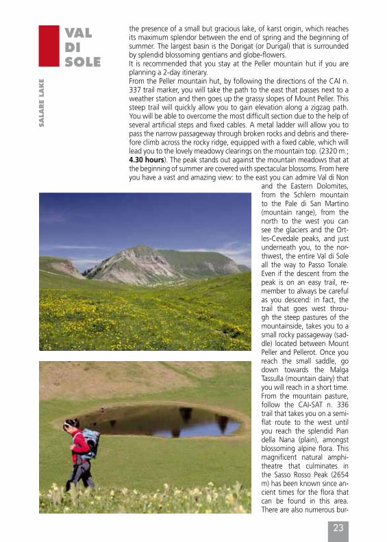
the presence of a small but gracious lake, of karst origin, which reaches its maximum splendor between the end of spring and the beginning of summer. The largest basin is the Dorigat (or Durigal) that is surrounded by splendid blossoming gentians and globe-flowers.It is recommended that you stay at the Peller mountain hut if you are planning a 2-day itinerary. From the Peller mountain hut, by following the directions of the CAI n. 337 trail marker, you will take the path to the east that passes next to a weather station and then goes up the grassy slopes of Mount Peller. This steep trail will quickly allow you to gain elevation along a zigzag path. You will be able to overcome the most difficult section due to the help of several artificial steps and fixed cables. A metal ladder will allow you to pass the narrow passageway through broken rocks and debris and there-fore climb across the rocky ridge, equipped with a fixed cable, which will lead you to the lovely meadowy clearings on the mountain top. (2320 m.; 4.30 hours). The peak stands out against the mountain meadows that at the beginning of summer are covered with spectacular blossoms. From here you have a vast and amazing view: to the east you can admire Val di Non
and the Eastern Dolomites, from the Schlern mountain to the Pale di San Martino (mountain range), from the north to the west you can see the glaciers and the Ort-les-Cevedale peaks, and just underneath you, to the nor-thwest, the entire Val di Sole all the way to Passo Tonale. Even if the descent from the peak is on an easy trail, re-member to always be careful as you descend: in fact, the trail that goes west throu-gh the steep pastures of the mountainside, takes you to a small rocky passageway (sad-dle) located between Mount Peller and Pellerot. Once you reach the small saddle, go down towards the Malga Tassulla (mountain dairy) that you will reach in a short time. From the mountain pasture, follow the CAI-SAT n. 336 trail that takes you on a semi-flat route to the west until you reach the splendid Pian della Nana (plain), amongst blossoming alpine flora. This magnificent natural amphi-theatre that culminates in the Sasso Rosso Peak (2654 m) has been known since an-cient times for the flora that can be found in this area. There are also numerous bur-
SALA
RE
LAKE
24
VALDISOLE
Elevation amsl: 2003. Location: MaléCatchment basin: Noce – Rio Val Sorda (stream)Mountain chain: The Brenta Group Hiking time: 9 hours Difficulty: EE – Excursion for experts Elevation gain: 1556 m
SAT trail N°: CAI-SAT n. 374 trail marker up to Peller mountain hut, CAI SAT n. 336 trail marker up to Passo della Forcola, n. 306 to Malga Clesera (mountain hut) and therefore n. 308 in the last section.Mountain huts: Rifugio Peller (mountain hut), Rifugio Mezol (this mountain hut is only a bivouac shelter)
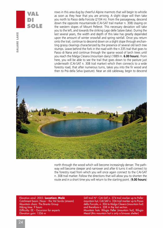
rows in this area dug by cheerful Alpine marmots that will begin to whistle as soon as they hear that you are arriving. A slight slope will then take you north to Passo della Forcola (2104 m). From the passageway, descend down the opposite mountainside (CAI-SAT trail marker n. 308) staying on the western slopes of Mount Pellerot. This necessary deviation will take you to the left, and towards the striking Lago delle Salare (lake). During the last several years, the width and depth of this lake has greatly depended upon the amount of winter snowfall and spring rainfall. Once you return onto the trail, continue to descend down on a slight slope through enchan-ting grassy clearings characterized by the presence of several old larch tree stumps. Leave behind the fork in the road with the n.335 trail that goes to Passo di Nana and continue through the sparse wood of larch trees until you reach the Malga Clesera (mountain dairy) (1889 m. 6.00 hours). From here, you will be able to see the trail that goes down to the pasture just underneath (CAI-SAT n. 308 trail marker) which then connects to a wide forestry road, that after numerous turns, takes you into the fir wood and then to Prà della Selva (pasture). Near an old cableway, begin to descend
SALA
RE
LAKE
north through the wood which will become increasingly denser. The path-way will become steeper and narrower and after 6 turns it will connect to the forestry road from which you will once again connect to the CAI-SAT n. 308 trail marker. Follow the directions that will allow you to shorten the route and in a short time you will return to the starting point. (9.00 hours)
VALDISOLE
17“Cinque Laghi” excursion
25
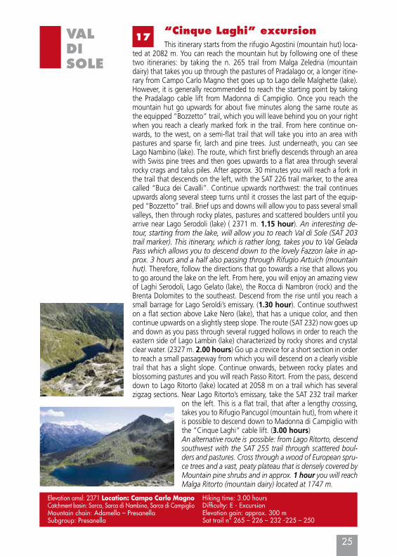
This itinerary starts from the rifugio Agostini (mountain hut) loca-ted at 2082 m. You can reach the mountain hut by following one of these two itineraries: by taking the n. 265 trail from Malga Zeledria (mountain dairy) that takes you up through the pastures of Pradalago or, a longer itine-rary from Campo Carlo Magno thet goes up to Lago delle Malghette (lake). However, it is generally recommended to reach the starting point by taking the Pradalago cable lift from Madonna di Campiglio. Once you reach the mountain hut go upwards for about five minutes along the same route as the equipped “Bozzetto” trail, which you will leave behind you on your right when you reach a clearly marked fork in the trail. From here continue on-wards, to the west, on a semi-flat trail that will take you into an area with pastures and sparse fir, larch and pine trees. Just underneath, you can see Lago Nambino (lake). The route, which first briefly descends through an area with Swiss pine trees and then goes upwards to a flat area through several rocky crags and talus piles. After approx. 30 minutes you will reach a fork in the trail that descends on the left, with the SAT 226 trail marker, to the area called “Buca dei Cavalli”. Continue upwards northwest: the trail continues upwards along several steep turns until it crosses the last part of the equip-ped “Bozzetto” trail. Brief ups and downs will allow you to pass several small valleys, then through rocky plates, pastures and scattered boulders until you arrive near Lago Serodoli (lake) ( 2371 m. 1.15 hour). An interesting de-tour, starting from the lake, will allow you to reach Val di Sole (SAT 203 trail marker). This itinerary, which is rather long, takes you to Val Gelada Pass which allows you to descend down to the lovely Fazzon lake in ap-prox. 3 hours and a half also passing through Rifugio Artuich (mountain hut). Therefore, follow the directions that go towards a rise that allows you to go around the lake on the left. From here, you will enjoy an amazing view of Laghi Serodoli, Lago Gelato (lake), the Rocca di Nambron (rock) and the Brenta Dolomites to the southeast. Descend from the rise until you reach a small barrage for Lago Seroldi’s emissary. (1.30 hour). Continue southwest on a flat section above Lake Nero (lake), that has a unique color, and then continue upwards on a slightly steep slope. The route (SAT 232) now goes up and down as you pass through several rugged hollows in order to reach the eastern side of Lago Lambin (lake) characterized by rocky shores and crystal clear water. (2327 m. 2.00 hours) Go up a crevice for a short section in order to reach a small passageway from which you will descend on a clearly visible trail that has a slight slope. Continue onwards, between rocky plates and blossoming pastures and you will reach Passo Ritort. From the pass, descend down to Lago Ritorto (lake) located at 2058 m on a trail which has several zigzag sections. Near Lago Ritorto’s emissary, take the SAT 232 trail marker
on the left. This is a flat trail, that after a lengthy crossing, takes you to Rifugio Pancugol (mountain hut), from where it is possible to descend down to Madonna di Campiglio with the “Cinque Laghi“ cable lift. (3.00 hours)An alternative route is possible: from Lago Ritorto, descend southwest with the SAT 255 trail through scattered boul-ders and pastures. Cross through a wood of European spru-ce trees and a vast, peaty plateau that is densely covered by Mountain pine shrubs and in approx. 1 hour you will reach Malga Ritorto (mountain dairy) located at 1747 m.
Elevation amsl: 2371 Location: Campo Carlo Magno Catchment basin: Sarca, Sarca di Nambino, Sarca di CampiglioMountain chain: Adamello – PresanellaSubgroup: Presanella
Hiking time: 3.00 hoursDifficulty: E - ExcursionElevation gain: approx. 300 m Sat trail n° 265 – 226 – 232 -225 – 250