Embed Size (px)
Citation preview
Summer’s Journey:The Indian Shale Quarries
of the Delaware River Valley and BeyondBy Jim Wade
The Native Americans who long ago lived throughout Mercer and Hunterdon counties, once quarried and traded great quantities of shale out of the hills and streambeds of central and northwestern New Jersey, including eastern Pennsylvania. One of the most sought after of these shales, known to geologists and archaeologists as argillite, was widely used by the Indians of this region for making stone tools. Argillite occurs in naturally dispersed outcrops in the mountains, rivers and streams of the Delaware Valley, and was scattered over the central New Jersey countryside. Argillite is a softer formed stone, making it more easily worked, and very adaptable to fashioning and making a variety of tools and weapons by the Indians. This is probably why it was chosen and used by the Indians of the Delaware Valley to a greater degree than any other stone resource. This shalaceous stone (hardened, clay-like stone) was readily avail-able and existed in great abundance. It could be transported and traded by the Indians when reduced and shaped into what are known by archaeologists as ‘blanks’ or ‘pre-forms’. These are stone tools that are only partially finished by the toolmaker, to be completed at a later time. The New Jersey Indians used various grades of shale-argillite for making specific tools and weapons. The Indians quarried and traded these materials with other local Indian bands. Argillite and other shales had a large trading range by the regional Indians, during the ‘Middle Woodland Period’, about 2,000-1,000 years ago. During this time period, the Indian people, known to archaeologists as the ‘Fox Creek Culture’, seem to have especially carried and traded argillite blanks or pre-forms over the widest area. Caches of Petalas Blades (broad butchering knives) and Fox Creek stone pre-forms have been found throughout the central and northwestern regions of New Jersey and eastern Pennsylvania. The most concentrated areas that argillite is naturally found is in eastern Pennsylvania, New Jersey, Delaware, Mary-land and southern New York. Argillite is concentrated mostly in
the upper Delaware Valley region, along both sides of the river. It is especially prevalent around Lancaster, Chester and Bucks counties. It is also commonly found in the northeastern regions of Pennsylvania in Wayne and Pike counties. In New Jersey, argillite is concentrated in the Byram and Flemington areas, and through-out much of southern Hunterdon County and western Mercer County.
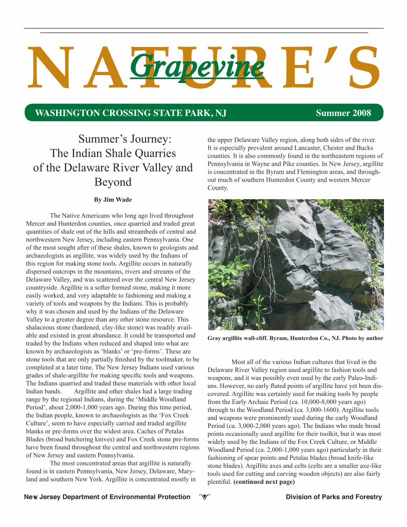
Gray argillite wall-cliff. Byram, Hunterdon Co., NJ. Photo by author
Most all of the various Indian cultures that lived in the Delaware River Valley region used argillite to fashion tools and weapons, and it was possibly even used by the early Paleo-Indi-ans. However, no early fluted points of argillite have yet been dis-covered. Argillite was certainly used for making tools by people from the Early Archaic Period (ca. 10,000-8,000 years ago) through to the Woodland Period (ca. 3,000-1600). Argillite tools and weapons were prominently used during the early Woodland Period (ca. 3,000-2,000 years ago). The Indians who made broad points occasionally used argillite for their toolkit, but it was most widely used by the Indians of the Fox Creek Culture, or Middle Woodland Period (ca. 2,000-1,000 years ago) particularly in their fashioning of spear points and Petalas blades (broad knife-like stone blades). Argillite axes and celts (celts are a smaller axe-like tools used for cutting and carving wooden objects) are also fairly plentiful. (continued next page)
NATURE’SGrapevine
New Jersey Department of Environmental Protection e Division of Parks and Forestry
WASHINGTON CROSSING STATE PARK, NJ Summer 2008

Origin of Shale and Argillite
Sedimentary deposits of windblown origin are found in New Jersey especially in the area of the Delaware River adjacent to Trenton where clay deposits were consolidated and com-pressed, and formed into shales. There are two types of shales that were used extensively by the Indians of this area for the production of stone points and other various tools. These are the red shales of the Passaic Formation (225-192 million years ago) and the gray-green argillaceous shale of the Lockatong Formation (a particular shale-argillite layer formed during the Triassic Period). The gray-green argillite of the Lockatong Formation was subjected to a greater degree of mineral infi ltration that served to tightly cement its particles together. This rock is thus, harder and more resistant to erosion and other damage than the red shales of the Passaic Formation. There are a variety of other color variants that argillite comes in such as purple, being one of the most prev-alent, then brown or tan, probably next. Argillite also occurs in green, black and gray, especially in the southern Hunterdon and Mercer County areas. Argillite being a compressed mudstone or siltstone tends to weather more so than most other kinds of rocks. Because of its fairly rapid deterioration, Indian stone tools made of argillite are usually much more eroded in form, than when they were originally made. But when argillite is freshly broken, it has a dark fresh appearance, and holds a good sharp edge when tooled.
Red shale wall-cliff. Raven Rock, Hunterdon Co., NJPhoto by author
Argillite In New Jersey
The argillaceous shales in New Jersey were formed dur-ing what geologists and paleontologists refer to as the Mesozoic Era (225-65 million years ago). The Piedmont region of central New Jersey formed during the late Triassic and early Jurassic Pe-
riod (230-190 million years ago). The rocks of this region of the Piedmont were created when a large elongated rift valley was formed, called the Newark basin. This continental interior basin held a succession of long, extended lakes, swamps, mud and sand fl ats that gradually fi lled with sediments. These sediments were compressed into the brown, red, dark purple, and gray-green rocks that are seen in the central New Jersey landscape today. The Piedmont Lowland terrain in general consists of low rolling hills that slope gradually from the New Jersey Highlands to the Coastal Plain.
Hunterdon County Plateau
The Hunterdon County Plateau makes up a prominent highland in the northwestern part of the Piedmont Lowlands between Flemington and Frenchtown. It is underlain predomi-nantly with the erosion-resistant Lockatong argillites. This is one of the major areas from which the Indians of this region obtained argillite to make their tools and to trade with other Indians. Along the Delaware River these rocks make up steep cliffs and slopes. Further east, lays an older separated terrain that has been eroded in the less resistant red Brunswick shales. Except for a few higher igneous ridges, the Hunterdon County Plateau encompasses some of the highest elevations within the Piedmont. This plateau is bordered on three sides by valleys and on the fourth by the New Jersey Highlands.
The Sourland Mountains Area
The Sourland Mountains make up an elongate upland extending in a northeast-southwest direction with its center a few miles north of Hopewell Boro. The Sourland Mountains are comprised of a tough coarse-grained igneous rock called diabase. The highest point is at 563 ft., south of the town of Neshanic and these hills average about 400 ft. in elevation over widespread areas. The high points of the Sourland Mountains would have been advantageous as look-outs for the Indians in spotting game animals and viewing far distances. A geologic fault running on a line from Neshanic through Hopewell Boro to Harbourton produced the Hopewell Valley and the sloping features on the southeast side of the Sourland Mountains. There is also a Flemington fault extend-ing from Lambertville through Sergeantsville, Flemington, and Lebanon also producing sloping features southwest of the Hunterdon Plateau. These sloping fault regions have been signifi cantly altered by erosion. Water erosion has worn the soft red Brunswick Shales into older separated rolling terrain sur-rounding the rising Sourland Mountains. These ancient faulted areas make up today’s valleys and lowlands and contain many of the area’s rivers and streams. The erosional forces of these waterways have exposed numerous natural outcrops of argillite and shale for the indigenous peoples to quarry and fashion stone implements. Much of the Sourland Mountains and the north-western regions of New Jersey have natural outcrops of argillite exposed along the many water courses. (continued next page)
Page 2 Natureʼs Grapevine Summer 2008
New Jersey Department of Environmental Protection e Division of Parks and Forestry

of Frenchtown. Argillite stone tool remains have also been found below the earthen floors from several Indian rockshelters dis-covered along the Delaware River, in northwestern New Jersey. Argillite rocks from central and northwest New Jersey were probably shaped into various rough-outs, blanks or “performs”, and transported by the Indians on foot, and possibly by canoe to Indian villages, where they were worked with more detail and shaped into spear and arrow points, drills, knives, scrappers, and many other kinds of tools.
Shale and argillite debris along the Rock Brook in Skillman, NJ Photo by author.
Argillite was punched out of rock outcrops and picked out of the ravines and creeks where much of the material lies ex-posed. It was also found along the sides of mountains and slopes. It was collected as small boulders of various size, out of which the Indians hammered smaller chunks to make their stone imple-ments. The Indians could determine good argillaceous material from poorer qualities by hitting the rock with another (preferably harder) hammerstone, such as of quartzite. If the argillite rock was of good quality when struck, it gave off a distinctive ring. Inferior argillite gave off a more dull sound. This technique of testing rocks for their quality was used by the Indians for most of the rock materials that were found in large sizes. Argillite was obtained in the Sourlands and along the Delaware near Byram.(continued next page)
Page 3 Natureʼs Grapevine Summer 2008
New Jersey Department of Environmental Protection e Division of Parks and Forestry
The Raritan River Basin
The Raritan basin is a broad expanse of an older, sepa-rate lowland lying along the course of the Raritan River, espe-cially the areas along the river’s North Branch and South Branch tributaries. The north and south branches of the Raritan follow the southeastward sloping surface of the Piedmont Lowlands with tributary streams flowing through natural valleys. The Piedmont Lowlands are made up of several large drainage basins. The broad basin of the Raritan, with its North and South branches, as well as the Millstone River and Stony Brook, drain the southern and west-central parts of the lowlands. This is a region of winding rivers with flood plains, many of which empty into the Delaware River from Hunterdon County. These tributary streams in this southwestern part of the Piedmont include the Hakahokake Creek near the town of Little York, the Nishisokawich, Copper and Warford creeks near Frenchtown, the Lockatong near Raven Rock, the Wickecheoke near Stockton, and Moores Creek, Fiddlers Creek, Woolset Brook, and Gold Run between Stockton and Trenton. The Indians of this region would have lived all along these various creeks, and brooks, many of which, would have had natural outcrops of argillite and shale to quarry and make tools. Flood plains at the lower levels and terraces at the higher levels are extensively developed along the Delaware River and the north and south branches of the Raritan, as well as with the main Raritan River., Large flood plains border the Raritan from New Brunswick extending westward. These would have been ex-cellent areas for the Indians to settle on and build their homes and hunt, fish, raise crops, and search out areas of exposed argillite and other stone resources.
New Jersey Indian Argillite Quarries
A large argillite quarry was discovered some years ago in the Flemington area, where the regional Indians mined this stone for use and trade. Historic journals and land surveys of the 17th Century indicate that there were several Indian trails that passed through the vicinity of Flemington The Malayelick Trail ran along Routes 579 and 31 and an Indian path that followed the course of present-day Route 12, from Frenchtown, would have served as argillite trade corridors. This can be ascertained by finds of this particular Flemington (purple) argillite as well as tools turning up on Indian sites as far from the original source, as eastern Mercer County, Monmouth County, and parts of south-central New Jersey. Outcroppings of argillite are found throughout the hills of Hunterdon County, and the rock is especially found exposed in the many streambeds. Some of the most prevalent quarries of argillite that were known to be heavily used by the Indians were located in the Charlestown area, in Bethlehem Township and near Byram, in Kingswood Township. Evidence of this argillite industry and quarrying has been found in the Walnut Brook Valley as well as in Klinesville and Cherryville, northwest of Flemington. Much of the native argillite found in central New Jersey originates in the broad regions of shale hills situated south

rounding hills, plateaus, and to the rivers and streams to quarry natural outcrops of shale and other stone materials for fashioning the tools and weapons they would need to hunt, fish, gather plants and perform a variety of tasks needed to survive. Men and older boys began to make excursions to the large outcroppings of shale and argillite to search out good quality veins of this stone. Quar-rying forays would have been made to the various streams, bluffs along the Delaware and outcrops mentioned earlier. There are several different grades and colors of argilla-ceous shales that were found by the Indians in the same location or region. When argillite is freshly cleaved with a hammerstone, it displays a tightly knit texture that renders it relatively easy to work into usable shapes. Argillite has been found to have been carried by the Indians over a much wider area than that of its home territory in the Delaware River Valley. It is especially found in the form of what archaeologists refer to as “Piedmont stemmed points” of the Late Archaic Period (ca. 6,000-4,000 years ago) and “Fox Creek Broad points” of the Middle Wood-land Period (ca. 2,000-1,000 years ago). Here, in the mountains, hills, cliffs, rivers and streams, the Indians quarried many varieties of shale, sometimes large blocks of argillaceous stone, and flaked them into Petalas blades (broad knife-like stone blades), stone points, and other useful tools. The Indians would spend several days ‘knapping’ or ham-mering and chipping these shale flakes, turning out hundreds of stone implements. The Indians would leave behind broken pieces of would-be tools that shattered in the process, along with large scattered amounts of chipping debris. The Indians could then load the partially made ‘pre-forms,’ stone blades and other tools (to be finished at a later time) into their animal skin backpacks or woven sacks, to carry back to their settlements. If they were near or located along a river or stream such as the Raritan or Delaware River, they would load them into dugout canoes and transport them back to their camps and villages. Each Indian family may have selected a few blades for their every-day tool use, but prob-ably most of these stone implement ‘pre-forms’ would have been buried in marked, shallow pits in such places as located in the lowland river valleys or interior mountain retreats. The river valleys such as the Raritan and Delaware River, and the mountains and hills as Pheasant Hill and the Sour-lands. Are rich in heritage. They were the locations where the regional Indians would share again with others, the catching and gathering of fish and participate in the hunt for prey. For now, the partially finished shale and argillite blades, would be stored away in their many designated shallow caches, ready to be used in the up-coming autumn-winter hunt, and next spring’s anticipated fish spawning runs of the Delaware River.
References
Chesterman, Charles W. & Low, Kurt E. National Audubon So-ciety Field Guide to North American Rocks and Minerals. Alfred A. Knopf, New York. A Chanticleer Press Edition. 1979, 1995.(continued next page)
It was also found around Belle Mead in an area known to “old timers” as ) “Indian Castle”, along Pheasant Hill, and along the streams of Roaring Brook, Rock Brook, in the Hopewell Val-ley, and along the Stony Brook and the Millstone River basins. Pits were dug by the local Indians along many of these streams, where argillite slabs and fragments were reduced into pre-forms. After these argillite rocks were reduced down into blanks or what collectors called, “turtle-backs,” they were then carried off to nearby encampments and villages where they were further reduced and flaked into a variety of implements or traded with other Indians, in the surrounding country.
Various argillite Indian artifacts from a variety of locations in Cen-tral Jersey. Photo by author.
Argillite artifacts as previously mentioned, have been found far removed from their origins and are fairly common in Monmouth County. Since this material does not naturally occur in the area of Monmouth County, it is thought by archaeologists that the Indians of the Hunterdon County area and further north, brought it to, or traded with Indian groups that lived through-out the Monmouth County region to the south and east. These argillite Indian artifacts found in Monmouth County are likely to have originated from the shale-argillite outcrops along the bluffs and palisades of the Delaware River, especially from the vicinity of Point Pleasant, Pennsylvania, and in the region of Frenchtown, New Jersey. The argillite artifacts found in eastern New Jersey and parts of southern New Jersey were probably imported from the Indians of the northwest mountain and hill country of the state (Sussex and Warren Counties) with a busy trade network in this material converging in the Flemington region, and spreading outward. If one were to imagine going back in time to the prehis-toric period, one could envision a scenario of the native peoples busying themselves in their late springtime activities of fishing and turning the soil of their fields for planting their crops, and looking forward to the coming of summer. The Indians would have gathered a variety of food during much of the spring, and having stored it away, were now ready to journey to the sur-
Page 4 Natureʼs Grapevine Summer 2008
New Jersey Department of Environmental Protection e Division of Parks and Forestry

New Jersey Department of Environmental Protection e Division of Parks and Forestry
Page 5 Natureʼs Grapevine Summer 2008
Cunningham, John T. New Jersey - America’s Main Road. Chapter 1: Geology: Molder of Destiny. Garden City, New York. Revised Edition. Doubleday & Company, Inc. 1976.
Fogelman, Gary L. Pennsylvania Chert - Identifying Some Of The Materials Used By The Indians Of Pennsylvania And Sur-rounding Area. The Lithic Book II. Section: Argillacous Shale & Argillite. Turbotville, PA. Fogelman Publishing Co. 1999.
Geologic Survey. Geologic Map Of New Jersey. The Geology Of New Jersey. Department of Environmental Protection. 1984.
Kraft, Herbert C. The Lenape: Archaeology, History, and Eth-nography. New Jersey Historical Society, Newark, New Jersey. 1986.
Kraft, Herbert C. The Lenape-Delaware Indian Hertiage: 10,000 B.C. - A.D. 2000. Lenape Books. Stanhope, N.J. 2001.
Philhower, Prof. Charles A. The Aborigines Of Hunterdon County, New Jersey. Westfield, N.J. Address delivered before the Monmouth County Historical Association Sept. 20, 1923. Proceedings Of The New Jersey Historical Society, January 1924. A Magazine Of History, Biography And Notes On Families. New Series. Vol. IX. 1924. Pgs. 22-40
Philhower, Prof. Charles A. The Aborigines Of Hunterdon County, New Jersey. Westfield, N.J. Proceedings Of The New Jersey Historical Society, October 1926. A Magazine Of History, Biography And Notes On Families. New Series. Vol. XI. 1926. Pgs. 508-525.
Prinz, Martin, Harlow, George, and Peters, Joseph. Editors. Simon & Schuster’s Guide To Rocks & Minerals. New York. The American Museum of Natural History. A Fireside Book. Pub-lished by Simon & Schuster Inc. 1977, 1978.
Toth, Stephen J. Professor of Soils. Rutgers University. Soils And Archaeology. (This is a text of a paper read before the Society on March 21, 1970 in New Brunswick). Archaeological Society Of New Jersey Bulletin. 1970. News Letters # 87 & # 88.
Widmer, Kemble. The Geology and Geography of New Jersey. Princeton, New Jersey. Volume 19 - The New Jersey Historical Series. D.Van Nostrand Company, Inc. The New Jersey Tercente-nary Commission. 1964.
Wolfe, Peter E. The Geology And Landscapes Of New Jersey. New York: Crane, Russak. 1977.
Zim, Herbert S. & Paul R. Shaffer. A Golden Guide - Rocks And Minerals - A Guide To Familiar Minerals, Gems, Ores, And Rocks. New York. Golden Press. Western Publishing Company, Inc. Racine. Wisconsin. 1957. ______________________________________Jim Wade worked as a field archaeologist and archaeological field assistant at several Indian sites throughout Central New Jersey. Mr. Wade also worked as an archivist with the N.J. State Museum documenting Native American land holdings in New
Jersey from the 17th & 18th centuries. He is a frequent volunteer at WCSP where he assists with our Native American and primitive technology events. Mr. Wade is available for talks and demonstra-tions to groups. His e-mail address is: [email protected].
Volunteer Notes
Jim Wade, Princeton, delivered an excellent presentation on the spring activities of the prehistoric Native Peoples of the vicinity of WCSP. Jim also authored the feature article for this edition of Natures Grapevine.
Dr. Ken Kremer, NASA JPL Solar System Ambassador and representing The Planetary Society, put on a great multimedia presentation on the latest developments on the exploration of our solar system.
Linda Rohleder, Rutgers University, made a very informative presentation on landscaping with native plants for the benefit of wildlife.
Pat Chichon, Lambertville, delivered a presentation on wild ed-ible plants that was as tasty as it was interesting.
Lou Beck, Washington Crossing Audubon, led a very informa-tive and fruitful spring bird hike in early May.
Ellen Coleman, Ewing, Nettie Rekowski, Ewing, and Terri Miller, West Trenton, came out to staff the Nature Center and to perform a variety of tasks.
Al Fitipaldi, Titusville, Priscilla Damiani, Ewing, and Nettie all came out to brush trails.
Matthew A. Strattman, Titusville, donated a rock tumbler and a plaster cast of a 200 million year old dinosaur track to the Nature Center.
The Nature Center observation beehive is back in operation thanks to the generosity of an anonymous volunteer.
New Jersey Department of Environmental Protection e Division of Parks and Forestry
Page 6 Natureʼs Grapevine Summer 2008
SUMMER PROGRAMSAT THE NATURE CENTER
The following is a list of activities being offered through the Nature Center at Washington Crossing State Park in Titusville, NJ. Some programs are offered free without registration requirements; some will require advanced registration as indicated below. A fee will be charged to motor vehicles entering the park on weekends and holidays 5/24 - 9/1 (Memorial Day weekend through Labor Day). All programs will initially meet at the Nature Center unless otherwise indicated. Attendance is limited and is available on a first-come, first-served basis. Children must be accompanied by an adult. In the event of inclement weather, some programs might be canceled. It is always advisable to call ahead before coming out. Phone: (609) 737-0609.
POND STUDY (6 - 10 yr. old) Sunday July 6, 1:30 - 3:00 p.m. Kids will use pond nets to collect and examine the various organ-isms that inhabit our pond. Meet at the pond by the park service entrance off of Church Road in Titusville. Advanced Registration required. Free.
NIGHT HIKE (6 yrs. - adult) Saturday July 12, 8:30 p.m. Explore the park for nature at night and have some good old fashioned fun on this naturalist-guided hike and campfire. Advanced registration required. Bring a flashlight. Free.
NATURAL DYES (all ages) Saturday July 19, 1:00 - 3:00 p.m. Many interesting colors can be derived from wild plants. Come out to learn how several of our more common plants can be coaxed to yield dyes for coloring natural fabrics and take home a few samples of your own. Advanced registration required. Park vehicle entrance fee; $5.00 per car.
FAMILY NATURE WALK (all ages) Saturday July 26, 1:00 - 2:00 p.m. Join us for an informal naturalist-guided trail walk. Park vehicle entrance fee; $5.00 per car
POND STUDY (6 - 10 yr. old) Sunday August 3, 1:30 - 3:00 p.m. Kids will use pond nets to collect and examine the various organ-isms that inhabit our pond. Meet at the pond by the park service entrance off of Church Road in Titusville. Advanced registration required after 7/1. Free.
NIGHT HIKE (6 yrs. - adult) Saturday August 9, 8:30 p.m. Explore the park for nature at night and have some good old fashioned fun on this naturalist-guided hike and campfire. Advanced Registration required after 7/8. Bring a flashlight. Free.
MONARCH MADNESS (all ages) Sunday August 31, 1:30 - 3:00 p.m. The monarch butterfly is a summertime classic here in Washington Crossing State Park. Come out for an introduction to the life cycle of this fascinating insect. We’ll show you how to locate monarch eggs and larva and how to build a simple hatchery for raising the creatures. Advanced registration required after 7/31 Bring an empty plastic 2 liter soda bottle. Park vehicle entrance fee; $5.00 per car.
FAMILY NATURE WALK (all ages) Saturday September 6, 1:00 - 2:00 p.m. Join us for an informal naturalist-guided trail walk. Free.
SOLAR OBSERVATION (all ages) Saturday September 13, 1:00 - 3:00 p.m. View magnetic sun storms safely through special filters on two telescopes. Observe sun spots, solar flares, prominences, and other solar phenomena. Learn how these storms can affect the Earth as well as other interesting facts about Earth’s closest star. Gene Ramsey of the Amateur Astronomers Association of Princ-eton will conduct this activity. Free.
TREES OF THE PARK (adult) Sunday September 14, 1:30 - 3:30 p.m. Washington Crossing State Park is home to scores of spe-cies of native trees and shrubs as well as many non-natives that have become naturalized. Join the park naturalist on a walk and learn how to identify many of the most common species. Advanced Registration required after 8/12. Free.
SOLAR OBSERVATION (all ages) Saturday September 20, 1:00 - 3:00 p.m. View magnetic sun storms safely through special filters on two telescopes. Observe sun spots, solar flares, prominences, and other solar phenomena. Learn how these storms can affect the Earth as well as other interesting facts about Earth’s closets star. Gene Ramsey of the Amateur Astronomers Association of Princeton will lead this activity Clear skies required. Free.
Nature Center events Continued

NATURE CRAFTS (all ages) Sunday September 28, 1:30 - 3:00 p.m. Leaves, seeds, fall wildflowers and other artifacts of nature can all be utilized to create some interesting projects. Come out to the Nature Center and let your imagination run wild. Advanced registration required after 8/26 .
SUMMER PROGRAMSAT THE VISITOR CENTER MUSEUM
Call (609) 737-9303The Visitor Center Museum has a new interpretive video entitled “Ten Crucial Days – The Road to Liberty.” This 27-minute video produced by NJN Public Television will be shown in the Visitor Center Museum’s auditorium every hour on the hour from 10:00 a.m. to 3:00 p.m.
HISTORY VIDEO – Independence. Friday July 4, 2:00 p.m. This 28-minute video interprets the unfolding drama of the struggle for Independence by our Founding fathers including Benjamin Franklin, George Washington and Thomas Jefferson.
MUSKET FIRING DEMONSTRATION. Saturday July 19, 2:00 p.m. Join a Park Historian for an interpretive talk about some of the weapons used during the American Revolution and their use during the Battle of Trenton. Included will be a musket firing demon-stration.
HISTORY VIDEO – Founding Fathers: Rebels With A Cause. Saturday August 2, 2:00 p.m. This 45-minute video introduces Sam Adams, John Hancock and John Adams, who will all play vital roles in the genesis of the revolutionary movement.
HISTORY VIDEO – Founding Fathers: Taking Liberties. Saturday August 9, 2:00 p.m. This 50-minute video tells the stories of Patrick Henry, Benjamin Franklin, George Washington and Thomas Paine as the colonies move forward to revolution.
HISTORY VIDEO – Founding Fathers: You Say You Want A Revelution. Saturday August 16, 2:00 p.m. This 50-minute video fol-lows our Founding Fathers from the Declaration of Independence through the Revolutionary War.
HISTORY VIDEO – Founding Fathers: A Heatlhy Constitution. Saturday August 23, 2:00 p.m. This 50-minute video tells the story of our Founding Fathers constructing a constitution and building a new democratic nation.
MUSKET FIRING DEMONSTRATION. Saturday August 30, 2:00 p.m. Join a Park Historian for an interpretive talk about some of the weapons used during the American Revolution and their use during the Battle of Trenton. Included will be a musket firing demonstration.
NEW JERSEY FRONTIER GUARD ENCAMPMENT. Saturday September 13 & Sunday September 14, 10:00 a.m. – 4:00 p.m. Visitors can enjoy an 18th century encampment by New Jersey’s colonial militia, which defended the western settlements of Sussex County prior to the American Revolution. The arts and crafts of frontier life and defense can be observed throughout the day.
SUMMER PROGRAMSAT THE JOHNSON FERRY HOUSE
Call (609) 737-2515 COLONIAL ICE CREAMS Saturday, July 5 11am-4pm Food Historian Susan Plaisted will demonstrate the art and the recipes of ice cream making in the 18th century at the Johnson Ferry House. Park vehicle entrance fee; $5.00 per car.
Page 7 Natureʼs Grapevine Summer 2008
New Jersey Department of Environmental Protection e Division of Parks and Forestry

NATURE’SGrapevineNatureʼs Grapevine is produced quarterly by the:
This newsletter is available free of charge. Requests to be included on the mailing list may be made by con-tacting the Nature Center.
Phone..........(609) 737-0609Fax...............(609) 737-0627Email............1washxing@superlink.netHours............Wed - Sat 9:00 a.m. - 4:00 p.m. Sun 12:00 p.m. - 4:00 p.m Sun 9:00 a.m. - 4:00 p.m. (summer hrs.) Closed Mon and TuesWebsite........www.state.nj.us/dep/parksandforests/ parks/washcros.html
Park Naturalist& Newsletter Editor......Wayne Henderek
Reprographics..............Janssen Pharmaceutica Titusville, NJ
New Jersey Department of Environmental Protection