Embed Size (px)
Citation preview
U.S. Environmental Protection Agency Region IX, San Francisco Navajo AUM Project
Grover Cleveland, Mine ID # 56 August 2010 1
Navajo Abandoned Uranium Mine
Site Screen Report
This form is for use at the site of abandoned uranium mines (AUM) located on Navajo Nation
lands. Applicable sites include all mine and mine features that have or have not undergone
reclamation by the Navajo Abandoned Mine Lands Reclamation Program, including features,
adits, pits and waste piles. Applicable sites also include all AUM sites listed in the USEPA
CERCLIS database, all sites listed in the 2008 AUM GIS Report issued by USACOE and
USEPA, all AUM sites on allotment lands associated with the Navajo Nation, and any and all
AUM sites not listed in any database located on Navajo lands. Reconnaissance of any sites
located on lands adjacent to Navajo lands that may be impacting Navajo lands will need to be
coordinated with the authorities appropriate to those lands.
The purpose of the form is to ascertain the status and location of the identified AUM site, and
record all immediate site information associated with the mine site. Decisions and
recommendations on what additional steps are needed will be provided on a separate document.
Grover Cleveland 1 AUM Site
Navajo AUM Northern Region
Prepared by:
Weston Solutions, Inc.
Contract: W91238-06-F-0083
12767.063.496.1111
August 2010
U.S. Environmental Protection Agency Region IX, San Francisco Navajo AUM Project
Grover Cleveland, Mine ID # 56 August 2010 2
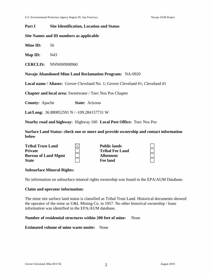
Part I Site Identification, Location and Status
Site Names and ID numbers as applicable
Mine ID: 56
Map ID: N43
CERCLIS: NNN000908960
Navajo Abandoned Mine Land Reclamation Program: NA-0920
Local name / Aliases: Grover Cleveland No. 1; Grover Cleveland #1; Cleveland #1
Chapter and local area: Sweetwater / Teec Nos Pos Chapter
County: Apache State: Arizona
Lat/Long: 36.880852591 N / -109.284157731 W
Nearby road and highway: Highway 160 Local Post Office: Teec Nos Pos
Surface Land Status: check one or more and provide ownership and contact information
below
Tribal Trust Land Public lands
Private Tribal Fee Land
Bureau of Land Mgmt Allotment
State Fee land
Subsurface Mineral Rights:
No information on subsurface mineral rights ownership was found in the EPA/AUM Database.
Claim and operator information:
The mine site surface land status is classified as Tribal Trust Land. Historical documents showed
the operator of the mine as U&L Mining Co. in 1957. No other historical ownership / lease
information was identified in the EPA/AUM database.
Number of residential structures within 200 feet of mine: None
Estimated volume of mine waste onsite: None
U.S. Environmental Protection Agency Region IX, San Francisco Navajo AUM Project
Grover Cleveland, Mine ID # 56 August 2010 3
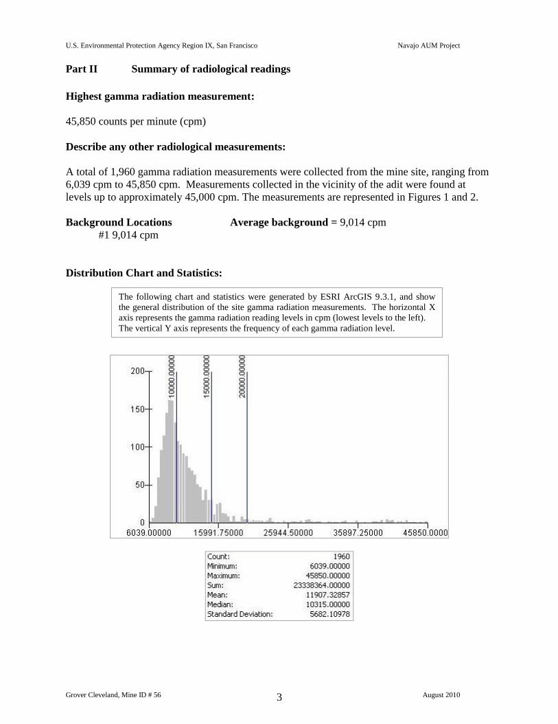
Part II Summary of radiological readings
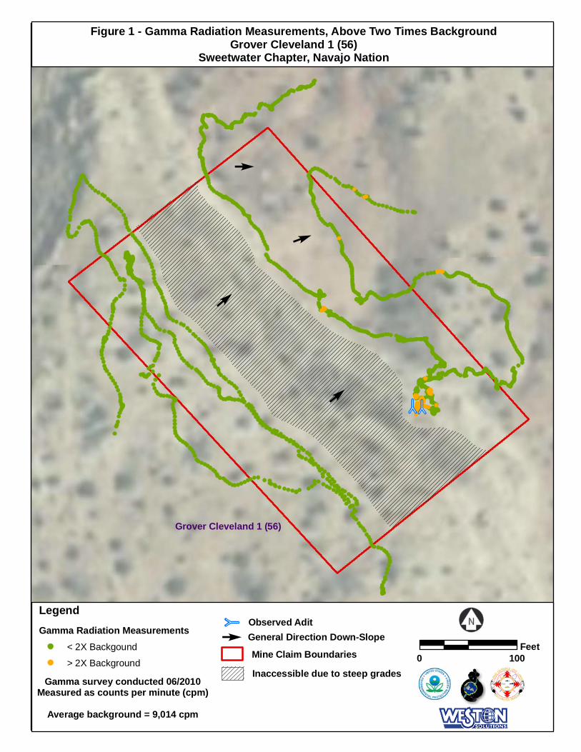
Highest gamma radiation measurement:
45,850 counts per minute (cpm)
Describe any other radiological measurements:
A total of 1,960 gamma radiation measurements were collected from the mine site, ranging from
6,039 cpm to 45,850 cpm. Measurements collected in the vicinity of the adit were found at
levels up to approximately 45,000 cpm. The measurements are represented in Figures 1 and 2.
Background Locations Average background = 9,014 cpm
#1 9,014 cpm
Distribution Chart and Statistics:
The following chart and statistics were generated by ESRI ArcGIS 9.3.1, and show
the general distribution of the site gamma radiation measurements. The horizontal X
axis represents the gamma radiation reading levels in cpm (lowest levels to the left).
The vertical Y axis represents the frequency of each gamma radiation level.
U.S. Environmental Protection Agency Region IX, San Francisco Navajo AUM Project
Grover Cleveland, Mine ID # 56 August 2010 4
Part III Status of Reclamation and Mine Waste
The following information was obtained from the Navajo Abandoned Mine Land
Reclamation Program (NAMLRP) Point Features Database:
NAMLRP Status of the mine site: Reclaimed : Yes Waste Pile onsite : No
NAMLRP Project Number: NA-0920
NAMLRP Mine features: 2 Portals, 1 Prospect
The following information was obtained from field observations collected during the 2010
site screening:
Provide description and status of all mine sites and features at site. Include all waste piles,
adits, pits and other features, and indicate whether they are open, closed, covered, capped,
buried or unreclaimed. Indicate approximate size, shape and extent, including description
of any reclamation caps. Note condition of all caps.
Observed reclamation work and status:
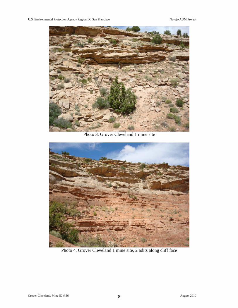
Adits
2 adits in north facing wall, cinderblock sealed
Waste Piles
None
Pits
None
Shafts
None
Other Debris and Mine Features
None
U.S. Environmental Protection Agency Region IX, San Francisco Navajo AUM Project
Grover Cleveland, Mine ID # 56 August 2010 5
Part IV
Site observations and Environs
Observed Structures: list number of and describe human habitation status of structures at
the following distances from mine:
0 to 200 feet: None
200 feet to 0.25 mile:
Observed Public or commercial structure: list and describe all schools, clinics, Chapter
Houses, places of business and any other structure used by members of the community at
the following distances:
0 to 200 feet: None
200 feet to 0.25 mile: None
Levels measured around the perimeter(s) of the identified structure(s):
Consistent with background levels
Observed water sources: list the number and type of wells and surface water sources that
are potentially used for human consumption at the following distances from the mine:
0 to 0.25 miles: None
0.25 miles to 4 miles: None
Sensitive environments: note and describe all sensitive environments located within visible
range of the mine site, including: wetlands, endangered species, habitats and approximate
locations of sites that may be under protection of the government of the Navajo Nation.
None observed
Known Site History: include information from interviews with Chapter officials and
residents. Note information on mine ownership, type of mining operation, period of
operation, known amount of production, and any other information as provided.
Grover Cleveland mine consists of an area of 9,503.84 m2. The mine was identified as being
operational in 1957. Historical documents showed the operator of the mine as U&L Mining Co.
in 1957. While operational, the mine had a total reported production volume of 28 tons. No other
historical information or any additional ownership / lease information was identified in the
EPA/AUM database.
U.S. Environmental Protection Agency Region IX, San Francisco Navajo AUM Project
Grover Cleveland, Mine ID # 56 August 2010 6
Part V Response Action Summary
Site Name(s): Grover Cleveland 1 Chapter: Sweetwater/Teec Nos Pos
Decision Criteria
Is there an unreclaimed waste pile at the site? No
At what distance from the waste pile is the nearest residential structure located? None
At what distances from the waste pile are there potential drinking water sources? None
Is there a reclamation cap or sealed adit in place at the site? Yes
Is the cap/seal functionally intact? Yes
Is the cap/seal sufficiently degraded to create a concern about releases? No
At what distance from the cap/seal is the nearest domestic structure located?
At what distance from the cap/seal is the nearest domestic drinking water source? None
Summary of emergency response factors
None
Summary hazard ranking system factors
None
Summary of reclamation factors
2 sealed adits
U.S. Environmental Protection Agency Region IX, San Francisco Navajo AUM Project
Grover Cleveland, Mine ID # 56 August 2010 7
Part VI Photos
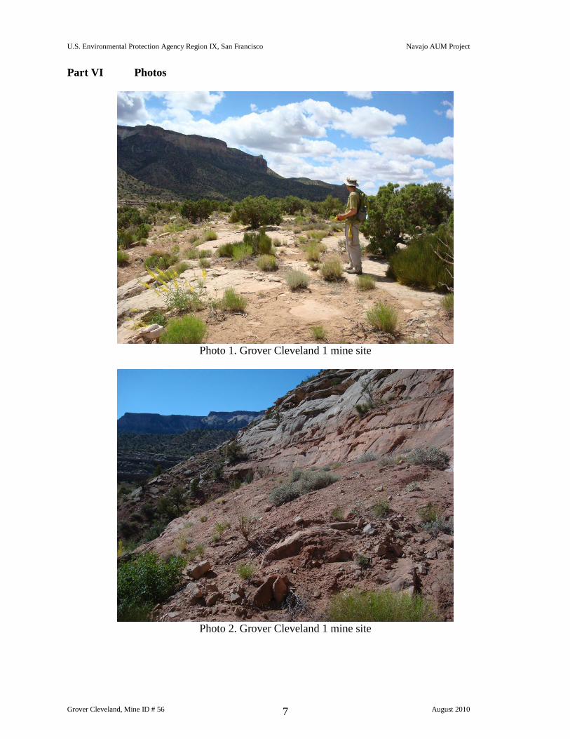
Photo 1. Grover Cleveland 1 mine site
Photo 2. Grover Cleveland 1 mine site
U.S. Environmental Protection Agency Region IX, San Francisco Navajo AUM Project
Grover Cleveland, Mine ID # 56 August 2010 8
Photo 3. Grover Cleveland 1 mine site
Photo 4. Grover Cleveland 1 mine site, 2 adits along cliff face
U.S. Environmental Protection Agency Region IX, San Francisco Navajo AUM Project
Grover Cleveland, Mine ID # 56 August 2010 9
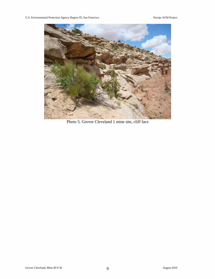
Photo 5. Grover Cleveland 1 mine site, cliff face
U.S. Environmental Protection Agency Region IX, San Francisco Navajo AUM Project
Grover Cleveland, Mine ID # 56 August 2010 10
U.S. Environmental Protection Agency Region IX, San Francisco Navajo AUM Project
Grover Cleveland, Mine ID # 56 August 2010 11
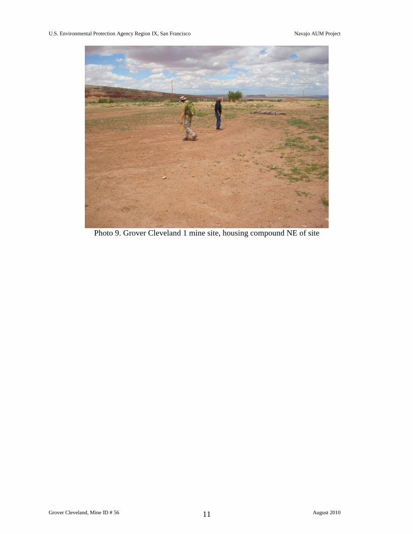
Photo 9. Grover Cleveland 1 mine site, housing compound NE of site
U.S. Environmental Protection Agency Region IX, San Francisco Navajo AUM Project
Grover Cleveland, Mine ID # 56 August 2010 12
Part VII Contacts Reports and Information
Name: Stanley Edison (928) 871-6861
Eugene Esplain (928) 871-7331
Title or official role (if any) Navajo EPA Superfund Program
Address___PO Box 2946, Window Rock, AZ 86515
Information provided Lead Regulatory Agency
Name:
Title or official role (if any)
Address
Information provided
Name________________________________________________________
Title or official role (if any) ____________________________________
Telephone number____________________________________________
Information provided_________________________________________________________
Name________________________________________________________
Title or official role (if any) ____________________________________
Telephone number____________________________________________
Information provided_________________________________________________________
Q Q
0 100Feet
Mine Claim Boundaries
Gamma survey conducted 06/2010Measured as counts per minute (cpm)
Average background = 9,014 cpm
General Direction Down-SlopeE
LegendGamma Radiation Measurements
< 2X Backgound
> 2X Background
Figure 1 - Gamma Radiation Measurements, Above Two Times BackgroundGrover Cleveland 1 (56)
Sweetwater Chapter, Navajo Nation
Inaccessible due to steep grades
Observed AditQ
E
Grover Cleveland 1 (56)
E
E
E
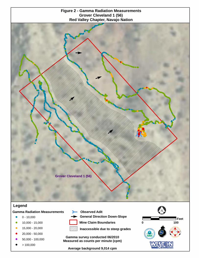
Q Q
0 100Feet
Mine Claim Boundaries
Gamma survey conducted 06/2010Measured as counts per minute (cpm)
Average background 9,014 cpm
General Direction Down-SlopeE
LegendGamma Radiation Measurements
0 - 10,000
10,000 - 15,000
15,000 - 20,000
20,000 - 50,000
50,000 - 100,000
> 100,000
Figure 2 - Gamma Radiation MeasurementsGrover Cleveland 1 (56)
Red Valley Chapter, Navajo Nation
Observed AditQ
Inaccessible due to steep grades
E
Grover Cleveland 1 (56)
E
E
E