Embed Size (px)
Citation preview
NAVAL POSTGRADUATE
SCHOOL
MONTEREY, CALIFORNIA
THESIS
Approved for public release. Distribution is unlimited.
A CONCEPT OF OPERATIONS FOR AN UNCLASSIFIED COMMON OPERATIONAL PICTURE IN SUPPORT OF MARITIME DOMAIN AWARENESS
by
Erin E. Wreski Erik A. Lavoie
March 2017
Thesis Advisor: Dan C. Boger Second Reader: Scot A. Miller

THIS PAGE INTENTIONALLY LEFT BLANK
i
REPORT DOCUMENTATION PAGE Form Approved OMB No. 0704–0188
Public reporting burden for this collection of information is estimated to average 1 hour per response, including the time for reviewing instruction, searching existing data sources, gathering and maintaining the data needed, and completing and reviewing the collection of information. Send comments regarding this burden estimate or any other aspect of this collection of information, including suggestions for reducing this burden, to Washington headquarters Services, Directorate for Information Operations and Reports, 1215 Jefferson Davis Highway, Suite 1204, Arlington, VA 22202-4302, and to the Office of Management and Budget, Paperwork Reduction Project (0704-0188) Washington, DC 20503. 1. AGENCY USE ONLY(Leave blank)
2. REPORT DATEMarch 2017
3. REPORT TYPE AND DATES COVEREDMaster’s thesis
4. TITLE AND SUBTITLEA CONCEPT OF OPERATIONS FOR AN UNCLASSIFIED COMMON OPERATIONAL PICTURE IN SUPPORT OF MARITIME DOMAIN AWARENESS
5. FUNDING NUMBERS
6. AUTHOR(S) Erin E. Wreski and Erik A. Lavoie7. PERFORMING ORGANIZATION NAME(S) AND ADDRESS(ES)
Naval Postgraduate School Monterey, CA 93943-5000
8. PERFORMINGORGANIZATION REPORT NUMBER
9. SPONSORING /MONITORING AGENCY NAME(S) ANDADDRESS(ES)
N/A
10. SPONSORING /MONITORING AGENCY REPORT NUMBER
11. SUPPLEMENTARY NOTES The views expressed in this thesis are those of the author and do not reflect theofficial policy or position of the Department of Defense or the U.S. Government. IRB number ____N/A____.
12a. DISTRIBUTION / AVAILABILITY STATEMENT Approved for public release. Distribution is unlimited.
12b. DISTRIBUTION CODE
13. ABSTRACT (maximum 200 words)
The maritime domain is an area of significant strategic concern to the United States and its allies. When the need arises, U.S. forces are able to detect and monitor vessels of interest (VOIs) in support of maritime interests throughout the world. However, current maritime domain awareness (MDA) processes lack the ability to provide actionable information in a timely and usable manner. Advances in intelligence, surveillance and reconnaissance (ISR) technology—particularly unclassified data sources, analytical processes and tools—available in the commercial sector could be leveraged to make MDA data more accessible and productive.
The purpose of this thesis is to establish a concept of operations (CONOPS) that will provide an unclassified maritime common operational picture (COP) with the capability to produce near-real-time shareable information from which all authorized interested parties can benefit. The research focuses on utilizing available unclassified commercial-off-the-shelf (COTS) capabilities to create a scalable and extensible platform that provides intelligence analysts and decision makers the ability to gain additional situational awareness and gather actionable information that can be quickly and easily shared with other services and international partners. Additionally, in an effort to prove the proposed CONOPS will work, the process was attempted utilizing some of these technologies.
14. SUBJECT TERMSmaritime domain awareness, commercial satellite imagery, feature recognition software, machine learning, information sharing, common operational picture, SPOTR, DigitalGlobe, SeaVision
15. NUMBER OFPAGES
125 16. PRICE CODE
17. SECURITYCLASSIFICATION OF REPORT
Unclassified
18. SECURITYCLASSIFICATION OF THIS PAGE
Unclassified
19. SECURITYCLASSIFICATION OF ABSTRACT
Unclassified
20. LIMITATIONOF ABSTRACT
UU NSN 7540-01-280-5500 Standard Form 298 (Rev. 2-89)
Prescribed by ANSI Std. 239-18

ii
THIS PAGE INTENTIONALLY LEFT BLANK
iii
Approved for public release. Distribution is unlimited.
A CONCEPT OF OPERATIONS FOR AN UNCLASSIFIED COMMON OPERATIONAL PICTURE IN SUPPORT OF MARITIME DOMAIN
AWARENESS
Erin E. Wreski Lieutenant Commander, United States Navy
B.S., Albright College, 2000
Erik A. Lavoie Commander, United States Navy
B.S., Jacksonville University, 2000 M.A., Naval War College, 2011
Submitted in partial fulfillment of the
requirements for the degree of
MASTER OF SCIENCE IN NETWORK OPERATIONS AND TECHNOLOGY
from the
NAVAL POSTGRADUATE SCHOOL March 2017
Approved by: Dan C. Boger Thesis Advisor
Scot A. Miller Second Reader
Dan C. Boger Chair, Department of Information Sciences

iv
THIS PAGE INTENTIONALLY LEFT BLANK
v
ABSTRACT
The maritime domain is an area of significant strategic concern to the United
States and its allies. When the need arises, U.S. forces are able to detect and monitor
vessels of interest (VOIs) in support of maritime interests throughout the world.
However, current maritime domain awareness (MDA) processes lack the ability to
provide actionable information in a timely and usable manner. Advances in intelligence,
surveillance and reconnaissance (ISR) technology—particularly unclassified data
sources, analytical processes and tools—available in the commercial sector could be
leveraged to make MDA data more accessible and productive.
The purpose of this thesis is to establish a concept of operations (CONOPS) that
will provide an unclassified maritime common operational picture (COP) with the
capability to produce near-real-time shareable information from which all authorized
interested parties can benefit. The research focuses on utilizing available unclassified
commercial-off-the-shelf (COTS) capabilities to create a scalable and extensible platform
that provides intelligence analysts and decision makers the ability to gain additional
situational awareness and gather actionable information that can be quickly and easily
shared with other services and international partners. Additionally, in an effort to prove
the proposed CONOPS will work, the process was attempted utilizing some of these
technologies.

vi
THIS PAGE INTENTIONALLY LEFT BLANK
vii
TABLE OF CONTENTS
I. INTRODUCTION..................................................................................................1 A. PURPOSE ...................................................................................................2 B. RESEARCH INTENT ...............................................................................3 C. SCOPE AND LIMITATIONS ..................................................................4 D. METHODOLOGY ....................................................................................4 E. ORGANIZATION OF THE RESEARCH ..............................................5
II. LITERATURE REVIEW .....................................................................................7 A. MARITIME DOMAIN AWARENESS ...................................................7
1. The Importance of MDA ...............................................................7 2. Information Sharing Basics ..........................................................8 3. Role of Trust ...................................................................................9 4. The South China Sea Problem ....................................................11
B. POTENTIAL UNCLASSIFIED MDA TOOLS ....................................14 1. Data Collection .............................................................................15 2. Data Processing ............................................................................20 3. COP Display .................................................................................22
C. IMPLEMENTATION .............................................................................24 D. CHAPTER SUMMARY ..........................................................................24
III. RESEARCH METHODOLOGY .......................................................................25 A. UNDERSTANDING THE CURRENT SOLUTIONS ..........................25
1. Analysis via Leavitt’s Diamond ..................................................25 2. Problems and Limitations ...........................................................34
B. DEVELOPING THE TO-BE MODEL ..................................................38 1. CONOPS Vision ...........................................................................40 2. Process Flows ................................................................................41 3. Feedback Mechanisms .................................................................52 4. Potential Use Cases ......................................................................52
C. CHAPTER SUMMARY ..........................................................................54
IV. DATA ANALYSIS ...............................................................................................55 A. CONOPS TEST METHODS ..................................................................55
1. Tasking ..........................................................................................56 2. Collection ......................................................................................57 3. Data Processing ............................................................................64
B. TESTING RESULTS...............................................................................64
viii
1. Manual Vessel Detection .............................................................65 2. Automated Results (SPOTR) ......................................................74
C. CHAPTER SUMMARY ..........................................................................86
V. CONCLUSIONS AND RECOMMENDATIONS .............................................89 A. SUMMARY OF RESULTS ....................................................................89 B. PROCESS IMPROVEMENTS...............................................................89 C. RECOMMENDATIONS FOR FUTURE RESEARCH .......................91
1. Import Imagery Data into SeaVision .........................................91 2. Transition to Future Capabilities ...............................................93
D. CONCLUSION ........................................................................................94
APPENDIX A. THE COMPLETE LIST OF COLLECTED IMAGES ....................97
APPENDIX B. DIGITALGLOBE NEXTVIEW LICENSE .....................................101
LIST OF REFERENCES ..............................................................................................103
INITIAL DISTRIBUTION LIST .................................................................................109
ix
LIST OF FIGURES
SPOTR Supporting Product Generation. Source: Faltemier et al. Figure 1.(2016). ........................................................................................................22
Leavitt’s diamond. Adapted from Leavitt et al. (1973). ............................26 Figure 2.
MDA OODA Workflow. Source: Hutchins et al. (2008). .........................29 Figure 3.
GCCS-M COP Display. Source: MR Popovich and Company Figure 4.(2010). ........................................................................................................31
Cooperative Situational Information Integration System (CSII) COP. Figure 5.Source: Marina (2013). ..............................................................................33
Singapore Unclassified COP. Source: Board (2008). ................................34 Figure 6.
Unclassified Common Operational Picture: System View ........................41 Figure 7.
Unclassified Common Operational Picture: Workflow .............................42 Figure 8.
SPOTR: Operational View. Adapted from Steinhaeuser (2016). ..............46 Figure 9.
SeaVision COP Display .............................................................................49 Figure 10.
SeaVision COP Display with Vessel Detail Selected ................................50 Figure 11.
Defined AOIs for CONOPS Test. Adapted from (1) “Chinese Naval Figure 12.Bases” (n.d.) and (2) Roach (2015). ..........................................................57
Screenshot of DigitalGlobe EV-WHS Interface Selections .......................59 Figure 13.
DigitalGlobe Image Download Process Options .......................................60 Figure 14.
DigitalGlobe Image Library Transfer Interface .........................................61 Figure 15.
DigitalGlobe Image Download Options ....................................................63 Figure 16.
SeaVision COP Display with User Defined Polygon over the SCS ..........66 Figure 17.
SeaVision Detailed Search, Rules Filtering and Query Results ................66 Figure 18.
Ling Nan 28 Correlation Process ...............................................................68 Figure 19.
Shen Yuan Zhua 67 Correlation Process ...................................................69 Figure 20.
Xin Hai Tun Correlation Process ...............................................................70 Figure 21.
x
Xin Hai Tun 2 Correlation Process ............................................................71 Figure 22.
Johnson South Reef Island Building Operations .......................................72 Figure 23.
Building Operations on Mischief Reef ......................................................73 Figure 24.
Time Lapse of Building Operations on Mischief Reef ..............................74 Figure 25.
Image of Scarborough Shoal with Cloud Cover ........................................77 Figure 26.
Image of Hong Kong .................................................................................78 Figure 27.
SPOTR’s Detection of Multiple Contacts in Close Proximity ..................79 Figure 28.
SPOTR’s Detection of Small Vessels ........................................................80 Figure 29.
SPOTR Detections in Obscure Environmental Conditions .......................81 Figure 30.
SPOTR Detections in Busy Port Areas ......................................................82 Figure 31.
SPOTR Detections of Military Vessels .....................................................83 Figure 32.
Future Capability: Change Detection .........................................................84 Figure 33.
Examples of SPOTR’s False Positive ........................................................85 Figure 34.
Two Vessels near Scarborough Shoal........................................................87 Figure 35.

xi
LIST OF TABLES
Example of Progeny’s Initial Results ........................................................75 Table 1.

xii
THIS PAGE INTENTIONALLY LEFT BLANK
xiii
LIST OF ACRONYMS AND ABBREVIATIONS
AIS Automated Identification System
AOI Area of Interest
AOR Area of Responsibility
AWS Amazon Web Services
C2 Command and Control
C4ISR Command, Control, Communications, Computers and Intelligence, Surveillance and Reconnaissance
C5F Commander Fifth Fleet
C6F Commander Sixth Fleet
C7F Commander Seventh Fleet
CAMTES Computer-Assisted Maritime Threat Evaluation System
CNN Convolutional Neural Network
COCOM Combatant Command
CONOPS Concept of Operations
COP Common Operational Picture
COTS Commercial-off-the-Shelf
CSII Cooperative Situational Information Integration system
CTAR Coalition Tactical Awareness and Response
DOD Department of Defense
DOT Department of Transportation
EO Electro-Optical
EOC Emergency Operations Center
EV-WHS Enhanced View-Web Hosting Service
FTP File Transfer Protocol
GB Gigabytes
GCCS Global Command and Control System
GCCS-M Global Command and Control System–Maritime
GeoTiff Geostationary Earth Orbit Tagged Image File Format
GSD Ground Sampling Distance
HTTPS Hypertext Transfer Protocol Secure
xiv
IC Intelligence Community
IMO International Maritime Organization
ISR Intelligence, Surveillance and Reconnaissance
IT Information Technology
JIATF-S Joint Inter-Agency Task Force - South
JWICS Joint Worldwide Intelligence Communications System
LRIT Long Range Identification and Tracking
MDA Maritime Domain Awareness
MSI Maritime Security Initiative
MSSIS Maritime Safety and Security Information System
NGA National Geospatial–Intelligence Agency
NIEM National Information Exchange Model
NIPRNET Non-Classified Internet Protocol Router Network
NITFS National Imagery Transmission Format Standard
NOAA National Oceanic and Atmospheric Administration
OODA Observe, Orient, Decide, Act
OPNAV N2N63 Chief of Naval Operations for Information Dominance
PKI Public Key Infrastructure
S-AIS Satellite-Based AIS systems
SAR Synthetic Aperture Radar
SCS South China Sea
SIPRNET Secret Internet Protocol Router Network
SME Subject Matter Expert
SPAWAR Space and Naval Warfare Systems Command
SPOTR Surveillance Persistent Observation and Target Recognition
TCPED Tasking, Collection, Processing, Exploitation, Dissemination
U.S. United States
UNCLOS United Nations Convention of the Law of the Sea
USB Universal Serial Bus
USN United States Navy
VMS Vessel Monitoring Systems
VOI Vessel of Interest
1
I. INTRODUCTION
The Naval Postgraduate School Information Science Department has proposed a
two-year campaign of integrated thesis research designed to explore and develop ideas
relating to the development of an unclassified maritime domain awareness (MDA)
concept of operations (CONOPS). U.S. forces are able to detect and monitor the maritime
domain in support of maritime interests around the world, but often lack the ability to
provide actionable information in a shareable, usable manner. This issue, in particular, is
an ongoing Commander Seventh Fleet (C7F) topic of interest due to the complex MDA
issues present in their area of responsibility (AOR). The intent of this thesis is to take the
first step in the development of a fully implementable CONOPS that leverages recent
developments in unclassified commercial-off-the-shelf (COTS) intelligence, surveillance
and reconnaissance (ISR) capabilities to build a comprehensive common operational
picture (COP). The overarching goal of the COP is to provide the who, when, what and
where for maritime vessels of interest (VOIs) adaptable to specific areas of interest
(AOIs) so that operators and intelligence analysts, who will infer the why and how, can
make informed actionable decisions and/or share data with interested parties.
MDA is defined as “the effective understanding of anything associated with the
maritime domain that could impact the security, safety, economy, or environment of the
United States” (White House, 2013, p. 2). It encompasses “all areas and things of, on,
under, relating to, adjacent to, or bordering on a sea, ocean, or other navigable waterway,
including all maritime-related activities, infrastructure, people, cargo, vessels, and other
conveyances” (White House, 2013, p. 2). What is happening in the waterways around the
world is becoming an increasing concern. Technological advances in recent decades have
provided an environment that has allowed the global capital market to grow and open
new economic opportunities via complex commerce pathways. The global supply chain is
becoming increasingly dependent on interconnected waterways to support these
expanding opportunities and, as a result, they have become essential to the United States’
national economy, commerce and security. However, the increasing number of countries
and vessels moving freely through these waterways is creating complex security issues.
2
Harmful and unlawful acts within this increasingly important domain can cause the
disruption or destruction of a physical and economic nature to the United States and its
partners (White House, 2012). There is no shortage of these threats to national security
and economic interests. These include terrorism, criminal activities, piracy,
environmental destruction, illegal immigration, and human and drug trafficking to name a
few (White House, 2013). The core principles of effective MDA promote a unity of effort
through proper information sharing and safeguarding in order to facilitate informed
decision making to ensure the safe and timely movements of legitimate commerce (White
House, 2013).
When the need arises, U.S. forces are able to identify and track VOIs in support of
these maritime interests. However, the means by which this data is collected and
processed often does not result in information quickly or in a form that is easily
shareable, which can result in lost opportunities. The data often comes from classified
sources. Additionally, data persistence is difficult to maintain because it is either too
expensive to sustain continuous operation of the sensor and/or there are too few
personnel or resources to commit to data and information gathering objectives. This
creates a reactionary environment for data analysts and decision makers who would
prefer to know and act on the threat before the damage is done.
A. PURPOSE
While the United States Navy (USN) is the lead agency primarily concerned with
MDA, each of the combatant commands (COCOMs) is assigned a different AOR that
results in different concerns and mission requirements. This has led to various technology
and information silos that do not easily share information of interest with other U.S.
agencies and foreign partners. However, increases in public domain information on
vessel tracking and the quality and periodicity of open-source commercial satellite
imagery as well as improvements in feature recognition software suggest that a non-
classified capability to recognize and track VOIs in the areas of USN operations may be
possible.

3
The purpose of this thesis is to addresses some of these issues inherent in the
current MDA construct by reviewing both the purpose of MDA and the current policies
governing it. Then, the current tools available with the capability to collect, process and
display unclassified maritime data are explored to determine how they might be
integrated to enhance MDA within this construct. The role of trust and classification is
also explored to determine the viability of such an unclassified MDA information system.
B. RESEARCH INTENT
In an attempt to better understand the relationship between the numerous
variables related to MDA in C7F and other COCOM AORs, this research attempts to
determine if the highly sought-after qualities in actionable MDA data, such as
information shareability, accuracy, reliability, frequency and quality, can be achieved
solely via unclassified means. Four specific issues were addressed. First, specific C7F
MDA objectives were clarified. Second, the value of non-classified MDA technical
approaches now and in the near future were determined. Specifically, whether or not data
persistency can co-exist with the ability to develop tracks on cooperative and non-
cooperative VOIs. Third, if an unclassified MDA CONOPS could be utilized to develop
maritime behavioral models that could deduce specific maritime activities, such as
fishing, illegal fishing, smuggling, military action and other activities of potential
national interest. Finally, broader strategic opportunities were investigated. To address
these issues, the following questions were specifically addressed:
1. What are the current MDA processes in C7F and other AORs?
2. What emerging capabilities and practices could improve C7F MDA?
3. Can these capabilities be integrated in a way to build increased situational awareness and sharing capacity?
4. What effects would an unclassified, sharable MDA construct have on strategic relations within the AOR?
This thesis will expand on existing MDA policies and procedures and introduce
new practices and operational concepts to enhance the current MDA warfighting concept,
expose issues and identify potential solutions. On the surface, while numerous policies
4
and architectures have been suggested, it does not appear that the United States, and C7F
in particular, have been able to fully leverage current unclassified MDA capabilities.
C. SCOPE AND LIMITATIONS
The scope of this study is considerable and encompasses numerous agencies and
classification levels. Some limitations included a lack of experience on the part of the
researchers at the operational level of command within the MDA enterprise to fully
understand the nuances involved. Additionally, the information sought for this research
was not always priority number one for staffs who are overworked and undermanned.
These concerns were mitigated by patiently gaining access to numerous individuals who
have worked and are currently working at the strategic, operational and tactical levels in
multiple AORs whose concerns mirrored the scope of this thesis.
D. METHODOLOGY
A qualitative approach toward research was performed to best identify gaps in the
current MDA policies and procedures and generate applicable recommendations.
Research was conducted to collect data on current MDA systems and workflows to
determine what might be leveraged or changed for future operations. This included
historical research, observation and discussion of current practices with operational
subject matter experts (SMEs) assigned to applicable AORs as well as those working in
research and development for new and future capabilities. Real world scenarios were
analyzed to determine what MDA tasks are normally completed, what priority they are
given, who was generally involved, what applications were generally used and how they
communicated with outside interested parties. Shortcomings and inefficiencies were
noted.
Working with the C7F sponsors and other stakeholders, a detailed analysis of
their particular processes was completed to establish possible solutions and process
changes to create operational improvements. Based on those findings, possible
technological and process improvements utilizing COTS products and capabilities were
explored in an attempt to optimize data collection, processing and integration into an
unclassified and shareable COP and a general workflow process model was developed
5
and tested. Finally, the research provides some future modification possibilities and uses
as well as challenges for the road ahead. Notably, if these capabilities can be leveraged
and integrated, the technical, operational and strategic implications must be determined
before practical implementation can occur. Concerns will exist over how much of this
data and derived information can and should be shared with coalition and allied partners.
E. ORGANIZATION OF THE RESEARCH
Chapter II provides a comprehensive literature review. This includes a thorough
explanation as to the importance of global MDA. Then, the recent improvements and
advances in ISR technology that could be utilized to build an unclassified COP are
discussed in detail. Chapter III breaks down the current methods of MDA utilizing
Leavitt’s diamond model to determine the gaps in the four major components of the
MDA enterprise and how possible solutions will affect each of them. A CONOPS is
proposed for a new method to achieve MDA via unclassified sources, processes and
displays along with examples of possible uses cases where this method would be
applicable. Chapter IV describes the testing methods that were used to validate the
proposed CONOPS to include examples of the data received and how it could be
employed to increase situational awareness and decrease workload throughout the MDA
enterprise. Finally, Chapter V presents conclusions based on the analysis and testing of
the suggested CONOPS and recommendations for future work and research.

6
THIS PAGE INTENTIONALLY LEFT BLANK
7
II. LITERATURE REVIEW
A. MARITIME DOMAIN AWARENESS
The maritime domain is an area of significant strategic concern to the United
States and its allies. It is the global common ground where commodities are exchanged,
wealth realized and, consequently, an area of opportunity for our enemies to threaten
national security and/or prosper from unlawful activities. It is where those seeking to gain
from illicit opportunities have the greatest chance of success. To properly confront these
threats extensive situational awareness will be required to enable effective decision
making (Bush, 2005). In order to monitor and prosecute illegal activities over such a vast
global area, concerned entities are becoming increasingly dependent on technology to
collect, process and share actionable data within this environment. The capability to build
a comprehensive COP with real-time and reliable data enables effective decision making
and appropriate action by the law enforcement, military and civilian entities involved.
1. The Importance of MDA
Admiral Mahan (1918) first suggested and codified “scouting” as one of the key
elements to successful naval engagements. This crucial requirement has not changed in
the intervening years, just the methods to achieve this goal. Ever since the devastating
attacks on September 11, 2001, the Federal Government has continued to develop and
revise domestic and foreign policies to combat the new and evolving threats posed by
irregular warfare and an increase in illicit activates occurring near and through our
borders. Previous to this, various departments exercised separate strategies that were
effective enough to provide a comfortable layer of security. However, in 2004, in
response to those attacks and other developing security concerns, President Bush directed
the Secretaries of Defense and Homeland Security, via the National Strategy for
Maritime Security, to lead an effort to develop a new national strategy for maritime
security that would integrate disconnected public and private departmental strategies into
one cohesive and effective national maritime strategy. This strategy, released in 2005,
called for the alignment of federal, state, local and private sector entities to form a more
8
cohesive and effective Maritime Strategy (Bush, 2005). In response, all the departments
that play a role in maritime security developed supporting plans to cover their specific
concerns and challenges. Each entity concentrated on a different aspect of MDA that fell
within their mission focus and developed a new strategy that could fit within the general
scope of a larger all-encompassing strategy that includes all the others (Boraz, 2009). For
this strategy to be successful, an increased willingness and capability to share information
across services, departments, agencies and national boundaries needs to exist.
2. Information Sharing Basics
According to Vice Admiral Morgan, Deputy Chief of Naval Operations for
Information, Plans and Strategy at the time, there are two key requirements needed to
build an effective COP, information and intelligence (Morgan & Wimmer, 2005). Both
are required fundamental components for improving maritime security, but with these
components come various operational, policy and legal ramifications (Klein, 2011). A
clear propagation and understanding of these rules and ramifications against strategic
initiatives are required to determine what can be shared and with whom. Using the term
“intelligence” often leads to the assumption of military interests and, with respect to
MDA, exclusivity in regards to the use of the oceans. However, MDA in the general
sense is more about the use of information regarding a common interest to promote
secure borders and safe international trade through secure shipping practices
(Klein, 2011). The international understanding of this need is evident in the adoption of
United Nations Convention on the Law of the Sea (UNCLOS) in 1982 by over 160
parties and its further revisions (Hong, 2012). UNCLOS defines the rights and
responsibilities of nations with respect to the development and sustainment of the world’s
oceans. It accomplishes this by outlining various guidelines and specific obligations
imposed on states in regards to the management of marine natural resources and vessel
safe passage. Among these specific obligations is the duty to share relevant information
that can assist in security issues relating to a state’s borders or the conduct of safe passage
(Hong, 2012).
9
Unfortunately, national security issues and the capabilities used to collect
information in reference to them will likely trump information sharing that does not
directly benefit the gatherer. This can cause delays in action that result in lost
opportunities. Collaborative approaches to information exchange need to be formally
endorsed in recognition of global needs to properly achieve MDA. The Obama
administration (2012) hoped to build on the Bush era strategies mentioned previously by
fostering an information sharing and safeguarding environment with nations who possess
a valid need and have met all access requirements. The expectation, outlined in the
National Strategy for Information Sharing and Safeguarding, is to enable accurate and
confident decisions and responses as well as further partnerships that promote and
facilitate MDA safeguarding and integration (Obama, 2012). Advances in information
technology (IT) can make this a reality by allowing information to flow freely across
jurisdictional and organizational boundaries. With access, however, comes
vulnerabilities.
The challenge lies in forming a single comprehensive capability that can receive
and fuse all the information coming from different sources into a common system that
will not overwhelm the user while meeting the security needs of all participating agencies
and allies. Additionally, in order to use the information most effectively a certain degree
of collaboration that provides the ability to share information quickly and effectively to
enhance operational support needs to exist (Morgan & Wimmer, 2005). Essentially, the
ability of analysts to collect and access relevant data, monitor their AOR, and allow a
flow of information between agencies and allies that can lead to effective communication
to detect and prevent illicit activities is of utmost importance for effective MDA.
3. Role of Trust
Knowledge is power and any gain in information will give the receiver added
advantage so there will always be a level of risk associated with any sharing of
information. The more handled, inconsistent, or fragmented the information shared the
higher the risk to national security. However, with well-defined and executed policies and
standards, comprehensive training and effective governance and accountability via
10
performance management and compliance monitoring, risk can be mitigated and a culture
of responsible sharing can be fostered (Obama, 2012). Realizing that sharing and
safeguarding information do not have to be mutually exclusive is important to increase
transparency, a requirement to foster trust, while enabling the appropriate confidentiality.
The advantage of utilizing unclassified tools for surveillance, detection,
classification, identification, location and tracking at the operational and tactical levels is
that the data derived, even when fused from multiple sources, does not divulge any
specific operational details beyond routine maritime surveillance. This creates a wealth of
easily accessible and shareable data, information vice intelligence, for use by national and
coalition partners while meeting national security objectives. Information moving
between data providers and consumers via defined common standards and protocols can
not only make this possible, but improving information gathering and dissemination
processes to provide products that are useful in various defined MDA mission sets.
Another benefit of an unclassified means to an end is the advantage of expedited
access to information by authorized users by removing the numerous roadblocks in
information sharing that currently exist due to the inherent over-classification of MDA
data. Often a by-product of the increasing demands on the intelligence community’s (IC)
time and effort due to big data, it has become the cultural norm to over-classify
information. Rather than doing the due diligence of appropriately marking information
sources, it is much easier to revert to a higher classification. The classification of
information from national technical means sources is in direct conflict with information
sharing. The United States and its allies have much to gain from the information sharing
and collaboration that could result from reversing this trend (Grimes, 2009). This will
require a shift from working in a culture of secrecy to a culture of sharing; a concept the
IC is likely to push back on due to various policies and procedures already in place that
can be difficult to navigate. The United States is normally bound by numerous bilateral
and multilateral agreements which can make knowing when and with whom information
can be shared difficult. These agreements permit the United States to share certain
classifications of data with other countries and no two agreements are the same. These
conflicting agreements pose significant problems in a classified COP architecture because
11
it requires unique data sets for each agreement that has been established. The Department
of Defense (DOD) Information Sharing Implementation Plan mentioned earlier was
developed specifically to help overcome these information-sharing challenges (Grimes,
2009). With input on sharing requirements and concerns from the COCOMs, military
departments and multiple defense agencies, this plan was developed to help these
agencies overcome differences in culture, governance, policy, resources and technology.
The plan also addresses management, operations and classification processes while
acknowledging the unprecedented capabilities to exchange information in a variety of
ways across the globe with today’s technology. It also touches on the issues of improper
and over-classification as impediments to the timely sharing of time-sensitive
information. This has eased concerns and paved the way for COCOMs to begin buying
into and adopting unclassified portals with foreign partners in their AORs to meet
specific mission needs (Grimes, 2009). An unclassified COP remedies this situation by
keeping the data and information assessable via collection and processing, but allowing
partners to analyze information themselves to derive their own actionable intelligence
that may or may not be shareable.
4. The South China Sea Problem
While all areas of naval operations offer complex MDA situations, the current
issues within the C7F AOR, particularly in the South China Sea (SCS) region, provide a
great example of the continuing need for effective MDA. Sovereignty disputes and land
reclamation among the six nations that rim the resource-rich SCS are becoming
increasingly common. This is creating greater tension and intensifying conflict in an
already volatile area of the world (Jackson, Rapp-Hooper, Scharre, Krejsa, &
Chism, 2016).
According to the DOD’s Asia-Pacific Maritime Security Strategy (2015), the
United States engages in many complicated bilateral relationships where the presence of
China, and their territorial views on the SCS, makes MDA particularly important. The
White House (2015) confirmed the United States’ interests in the SCS in 2015 when it
released a fact sheet entitled “U.S. Building Maritime Capacity in Southeast Asia” which
12
outlined funding commitments, security programs and the need for increasing
cooperation and coordination with allies in the region, including the Philippines,
Vietnam, Indonesia and Malaysia. This document also reaffirms the United States’
commitment to improving maritime security capabilities in Southeast Asia by developing
credible maritime capabilities and seeking new opportunities for collaboration. Other
United States’ funded maritime capacity building efforts are contained in the general
foreign military financing program and via other specific departments or bureaus. For
example, the U.S. State Department’s Bureau of International Narcotics and Law
Enforcement Affairs designated $25 million to develop the Southeast Asia Maritime
Security Law Enforcement Initiative (Parameswaran, 2016).
Announced in June 2015, the Southeast Asian Maritime Security Initiative (MSI)
reinforced collaboration efforts by calling for a focus on building a regional capacity
through ally and partner maritime capabilities to better address numerous maritime
challenges (Cronin, 2016). At the forefront of these challenges is China’s increasing
aggression in the SCS area. A five-year, $425 million DOD-funded project, MSI’s
primary goal is to enhance MDA through detection, understanding and sharing maritime
information in the SCS so that all interested parties share a common picture. Specifically,
it aims to create enhanced regional capabilities that can regularly update a COP that will
enhance the Southeast Asian states’ capacity to detect, analyze, respond to and share
valuable information about maritime activities in the SCS (Cronin, 2016).
Within the C7F AOR, it will be challenging to build this level of capacity. MDA
collaboration between the United States and Southeast Asian governments in the C7F
AOR is currently very limited. On top of each country having their own ISR capabilities,
numerous bilateral and multilateral relationships exist, like Singapore’s Information
Fusion Center and multilateral cooperative endeavors such as the Malacca Straits patrols,
which makes cooperation difficult (Parameswaran, 2016). Because the extent of these
capabilities varies widely and there is very limited participation from external sources in
local networking, numerous gaps continue to exist between actual and desired capabilities
(Jackson et al., 2016). For instance, a crucial Filipino armed forces security gap identified
in the Sulu and Celebes Seas resulted in over eighty percent of MSI funding to be focused
13
on bridging that one specific gap (Cronin, 2016). Gaps like this and others create
obstacles in the ability and desire of entities within the region to share information.
Taking advantage of the recent advances in technology, however, if implemented
correctly, could bridge those gaps and create a more robust complete MDA COP to
enable persistent collaboration opportunities within the C7F AOR and beyond.
Even if the technology gaps inherent in the current information sharing processes
are overcome, readily available data and imagery shared throughout such an unsteady
AOR will have a strategic impact. In his book, Asia’s Cauldron, author Robert Kaplan
(2014) paints a portrait of considerable shared distrust of Chinese intentions by other SCS
nations. Despite shared concerns, there has been very little collaboration between these
nations to address this intent. Building a shared COP that includes maritime awareness
and shared ISR data is attainable, but the two need to be viewed together in balance in
order to reach an attainable solution.
Beyond the mistrust between the nations surrounding the SCS, the perceptions of
United States led initiatives, such as MSI and ongoing relationship building strategies in
the region, are not always positively received. Some may view MSI as a U.S.-led effort
directed against China, which could compromise relationships individual countries have
with Beijing. In order to be successful, the United States will have to convince countries
involved to commit to their initiatives. Not all participants may be so willing to share
their information not only with the United States but amongst their neighbors due either
to a lack of trust or pre-existing rivalry. For example, Malaysia and Indonesia still refuse
to join 20 other Asian states in the Regional Cooperation Agreement on Combating
Piracy and Armed Robbery Against Ships in Asia based partly on a disagreement in the
Singapore location of the information sharing center headquarters (Parameswaran, 2016).
Working together with various agencies and foreign partners to develop transparent,
comprehensive and cooperative strategies will go a long way to foster confidence and
trust (Walker, 2013).
With such a broad variety of concerns and mission sets within the maritime
domain, the goal, then, is to produce an easily accessible COP using a limited amount of
resources. The enhanced joint awareness this system will provide gives commanders and
14
decision-makers timely, accurate information with which to direct forces confidently and
effectively. Technology can provide a means to share information by monitoring
activities, but decisions and processes will still have to be determined via policy. This
research intends to determine which technical capabilities exist that can make an
unclassified COP a reality, identify what remaining technical roadblocks exist that might
hinder these emerging capabilities from achieving the desired result, and finally, discover
the possible operational and strategic issues identified by such a capability and how to
best address them. Successful integration of commercial technological advances to
enhance maritime domain awareness that can transcend international boundaries has
already been proven on a limited basis and will be discussed more in depth in Chapter III.
B. POTENTIAL UNCLASSIFIED MDA TOOLS
Technology improvements in the ISR field have accelerated rapidly over the past
two decades. These developments have become an increasingly important strategic
requirement for those who require actionable intelligence for the protection and security
of their borders, economic activities and maritime traffic. There is an unprecedented
amount of resources feeding increasing amounts of data into networks on various systems
for end users to analyze. This data, when properly integrated into the current MDA
construct, can increase the speed and quality of information produced. Some examples
include long-range over the horizon radars, high altitude, long-dwell unmanned aerial
vehicles, oceanic surveillance buoys, acoustic systems and an ever-growing fleet of
military and commercial satellites. However, few of these have afforded the United States
a means to collect rapidly actionable unclassified data that can be shared between
independent agencies, multinational allies and law enforcement agencies
(Mugridge, 2012).
Advances in technology, particularly analytical processes and tools, available in
the commercial sector could be leveraged to make MDA data more accessible, effective
and available at a faster rate. This could significantly shorten the observe, orient, decide
and act (OODA) loop, allowing commanders and analysts more time to focus on mission-
critical tasks. This thesis will only assess open-source unclassified technologies and their
15
capabilities that can be leveraged in order to determine their value to provide the end user
with actionable, shareable data from collection to display.
1. Data Collection
With all the new and enhanced commercially available technology available,
there are numerous tools that can be leveraged to gather data for input into a COP that
can be accessed and updated by a multitude of authorized users. These tools encompass a
wide range of assets from orbiting satellites to earth-bound radar and sensors to numerous
onboard and off board vessel tracking systems. These systems have become so advanced
and prolific that they can provide a constant stream of information to aid in tracking both
cooperative and uncooperative vessels.
a. Satellites
The biggest increase in the accessibility of data in recent years is due to the
evolution of the satellite market. Recent advances in technology have allowed engineers
to transition from the large, costly, complex satellites to smaller, less complex cheaper
versions. Additionally, it has become cheaper and easier to launch satellites into orbit.
This has led to a notable increase in the number of small private organizations putting
their own vehicles in space (Baylis, Kroll, & Madon, 2016). Based on a report released
by the Tauri Group (2016), the number of satellites launched per year from 2011–2015
increased 36% over those launched in the previous five years. Consequently, there are
1,381 operational satellites in orbit, an increase of 39% since 2011 (Tauri Group, 2016).
This data provides a unique view that is unmatched in any technological sector on the
ground. As a result, commercial companies are able to sell an increasing amount of open-
source data from their satellites. Previously, imagery and access to these satellites that
has been available to only a small number of organizations, such as government space
agencies and research institutions, but it is now becoming widely available to the public
for a fee (Baylis, Kroll, & Madon, 2016).
Most useful to the maritime domain is a satellite’s ability to observe and record
the earth’s surface. Currently, there are two observation technologies, electro-optical
(EO) and synthetic aperture radar (SAR), which can generate vessel tracking imagery.
16
These payloads are carried on different systems and can be stand alone or work together.
Each system has its advantages and disadvantages which will ultimately determine its
usefulness for different mission sets. The full-color EO imagery is flashier and has been
around quite a bit longer, but requires daylight and clear weather to prove useful. At a
high resolution, it can provide a wealth of information beyond mere detection; providing
such details that may lead to classification and identification of a vessel to include course
and speed. Typically, these satellites have been primarily used for environmental
monitoring, meteorology and map making. SAR, however, can provide useful
information regardless of weather or time of day which guarantees data will be received
within the AOI, but is limited to the presence of an object, its location and possibly, the
direction of motion (Parker, 2012).
Earth imagery and analysis has become big business. For years, only a limited
number of companies offered earth observation services, but new competitors and
partnerships have emerged with funding no longer being driven by the space industry, but
increasingly by the IT sector. DigitalGlobe, Airbus Defense & Space, TerraBella and
ImageSat International are just a few notable companies that provide EO and SAR
imagery and analysis (Tauri Group, 2016). Not only have the number of satellites
increased, but the technology to take pictures from space has advanced significantly, with
leading-edge imagery now less than 0.3m-resolution (DigitalGlobe, 2014). Prior to 2014,
the U.S. Government banned commercial companies from publicly releasing images with
a pixel resolution greater than 0.5m for national security reasons. According to
DigitalGlobe (2014), concerns of a significant loss in market share due to rapid advances
by non-U.S. earth observation companies has led the U.S. Department of Commerce to
grant them and others permission to sell their highest-resolution photographs, up to
0.25m panchromatic and 1.0m multispectral ground sample distance (GSD) to the public
in 2014. At this resolution, you can not only see a car, but determine its make
(DigitalGlobe, 2014).
This preponderance of available imagery creates large data sets, which when
analyzed correctly, are already solving extensive problems in environmental
conservation, natural resource management, humanitarian aid and human migration
17
(Baylis, Kroll, & Madon, 2016). Once imagery processing is streamlined, actionable
imagery and its accompanying metadata can be available within hours (Baylis et al.,
2016). To help organizations handle the dramatic increase in incoming data, satellite
companies are now offering storage, data mining and analysis services by means of
manual and automated machine learning for a fee. Companies that provide such data
analysis include DigitalGlobe, Orbital Insight, Descartes Labs and Tellus Labs, but none
have developed an automated maritime imagery recognition capability that has been
advertised.
b. Coastal Radar Systems
Radar imagery is not only produced from space, but also on the ground. With
increasing maritime security concerns, ground radar and acoustic surveillance systems
have become more common. Coastal radar systems, such as STYRIS CSS, utilize various
sensors built along the coast. These sensors acquire data and feed into the company’s
database where it is fused with other data feeds to create a maritime picture providing
increased command and control (C2) capabilities (Signalis, 2015). Also of note, passive
acoustic methods which detect ships based on the detection of sound are becoming an
increasingly effective maritime sensor. For example, the Stevens Passive Acoustic
System can detect and classify ships via simultaneous acquisition and analysis of acoustic
signals (Sutin et al., 2010).
c. Vessel Tracking Systems
There is also an assorted array of vessel tracking systems operated by various
organizations for different purposes; the most often cited being maritime safety and
security. The commercially available Automatic Identification System (AIS), Long-
Range Identification and Tracking system (LRIT) and Vessel Monitoring System (VMS)
are the three prominent tracking systems used globally.
AIS is an open, non-proprietary communications system sanctioned by the
International Maritime Organization (IMO) to promote safety and transparency in
maritime traffic. It is mostly used to supplement marine radar, the primary method of
collision avoidance for water transport. Effective December 2004, IMO required all ships
18
of 300 gross tonnage and upwards in international waters, cargo ships of 500 gross
tonnage and upwards not engaged on international voyages and all passenger ships
irrespective of size to carry AIS systems (IMO, n.d.). The AIS system, when used
properly, transmits and receives information via an onboard transponder that passes a
wealth of information to other ships and shore-based facilities including ship
identification, type, position, speed, course, status and various other safety related
information (IMO, n.d.). This information can and is shared freely at the unclassified
level. Numerous websites already exist for anyone with account access to view AIS track
information such as marinetraffic.com, vesselfinder.com and fleetmon.com. However, the
level of vessel information displayed is often fee dependent.
There are limitations to AIS. Traditional AIS signals have to be routed back to a
shore-based receiving station. This can be done directly if the vessel is within close range
to shore or via a relay system built into the AIS transceiver. When vessels are beyond the
acceptable range, far out to sea, the AIS signal cannot be received. A satellite-based AIS
system (S-AIS) embedded in micro-satellites that is able to detect and process AIS
information transmitted from vessels beyond the range of traditional AIS receivers has
been developed to mitigate this issue. This, however, requires a cost to upgrade the
system on the vessel, so it may not be cost-effective for the ship to utilize the upgraded
system (Thomas, 2013). Companies such as ORBCOMM, ExactEarth, Spacequest and
Spire are currently deploying this technology. Other issues include spoofing, hijacking,
availability disruption and general voluntary compliance. Beyond the aforementioned
regulations, there is no standard of how the system is used. Individual vessels are able to
input fraudulent information (Balduzzi, Pasta, & Wilhoit, 2014). Therefore, while it
provides an unclassified and shareable platform, used alone, AIS is an ineffective system
to achieve effective MDA. The information derived from AIS will need to be validated
and/or fused with other sensors, databases and displays that are unclassified and
shareable to be considered reliable and valuable.
In contrast to AIS, primarily a short-range collision avoidance system, LRIT is a
system specifically designed for long range operations. Initiated by the IMO in 2006, it is
a satellite based communication system for vessel identification and tracking built

19
primarily for ship types engaging in international voyages, including all passenger ships,
high-speed craft over 300 gross tonnage, cargo ships and mobile offshore drilling units
(Chen 2013). The IMO requirement states that these ships must report to their flag
administration four times a day. The use of LRIT on vessels follows the same
characteristics as AIS, but there are a few key differences. AIS has more information
categories in its database providing more information on a vessel. Also, LRIT, unlike the
passive AIS system, requires active participation via a two-way link between ship and
shore offering a higher degree of credibility (Chen, 2013). While AIS and LRIT are used
for different purposes and slightly different capabilities, they are complementary and can
be used in conjunction with one another to provide more reliable information.
The third system, VMS, is a satellite-based, closed, proprietary system used in the
commercial fishing industry and managed by the National Oceanic and Atmospheric
Administration. According to the program website (NOAA, n.d.), unlike AIS and LRIT,
VMS is merely a one-way transceiver that is installed on vessels that leverages satellite
communications in order to pass information back to ecological and fishery regulatory
organizations for tracking and monitoring purposes. The transceiver sends position
reports that include vessel identification, time, date and location about once an hour or
more often if the vessel is approaching an environmentally sensitive area. The system is
typically used to observe vessels operating in the territorial waters and 200-nautical mile
exclusive economic zones of many countries in order to increase the control and
sustainability of the maritime environment by verifying proper fishing procedures and
deterring illegal fishing activities (NOAA, n.d.).
While all these systems provide information and benefits for different purposes,
the real advantage for maritime authorities and MDA intelligence analysts lies in the
comparison of information reported in these systems. Data received from these various
systems can be compared to verify that correct information is being reported by a
particular vessel and provide a wealth of unique data to identify specific vessel activity to
build a reliable snapshot of a particular AOI. For MDA analysis, the use of this
information is particularly useful to build historical tracks and a more comprehensive
COP to determine any abnormal behavior.
20
2. Data Processing
The proliferation of data caused by the boom in the satellite imagery industry that
is making high-resolution imagery readily available also comes with big challenges
(Baylis et al., 2016). The bandwidth, storage, computer processing power and expertise
required to process high-resolution imagery and big data analysis becomes the next
hurdle. Information received from various ISR sensors is generally received in a raw data
format that is not suitable for interpretation and analysis. Processing this data into a
usable and meaningful format so that it can be analyzed is a greater challenge.
Traditionally, information gained from satellite imagery has been processed manually
due to the need for high accuracy in deriving the information necessary for the level of
decision making required (Baylis et al., 2016). However, this requires highly skilled
analyst and a considerable amount of time to complete data and image processing tasks.
As more data is becoming available at increasingly high rates, this process is becoming
unmanageable for most intelligence analysts. Not only is it time-consuming, but manual
classification is subject to bias (Baylis et al., 2016). So, this approach is increasingly
unfeasible.
With these challenges in mind, many of the commercial satellite imagery
providers have developed processing-intensive imagery analysis platforms to handle the
incoming data directly. Automatic detection through the use of advanced computer
algorithms, including machine learning capabilities in some cases, can sift through large
amounts of data in a fraction of a second compared to human users, saving time and
money. Because this technology is still in its infancy, few organizations within the DOD
use these methods for two reasons, the lack of computer processing capabilities and
qualified data engineering expertise (Baylis et al., 2016). Commercial companies,
however, seeing the benefits of enhanced machine learning algorithms to extract
intelligence from big data, are directing considerable resources towards acquiring this
capability. This allows them to automatically extract useful information from large data
sets that would impossible to replicate manually. Google, DigitalGlobe and Orbital
Insight, as well as a few smaller startup companies, already offer such services and have
21
proven successful in a number of instances, including tracking human rights violations
and migration patterns (Baylis et al., 2016).
Currently, all of the commercial systems and companies mentioned have their
own ground station downlinks, including the military, for their particular satellites. They
do not, however, possess the capability to talk to each other, so for the present time, any
imagery being processed and delivered to DOD systems will incur a delay as it is routed
through the commercial company’s infrastructure first. However, capabilities exist to
inexpensively format data for use in a standards-based downstream processing chain or
transform it to be compatible with legacy DOD IT infrastructures to meet real-time
requirements, an important capability for making data shareable throughout the DOD and
its foreign partner’s various systems.
With commercially available imagery of sufficient resolution now available, it is
possible to apply advanced feature recognition techniques within the MDA construct to
detect and possibly classify and identify vessels anywhere in the world (Bannister &
Neyland, 2015). Progeny Systems, located in Manassas, Virginia, is currently developing
their feature recognition tool, known as Surveillance, Persistent Observation and Target
Recognition (SPOTR), for use in the maritime domain. Similar to facial or biometric
recognition tools, SPOTR is a suite of image processing, computer vision and pattern
recognition tools that use machine learning and feedback mechanisms to create more
intelligent and adaptable techniques for classification and identification of objects
(Faltemier, Steinhaeuser, Miller, & Paradis, 2016). By analyzing commercial satellite
imagery with near-real-time processing, it can detect, classify and identify ships at sea
and in port using these capabilities. With an extensive vessel library to draw from,
detection and classification can occur in less than a minute and is still improving.
Additionally, it can be further suited to a particular task based on a smaller search space
(Faltemier et al., 2016). In time this capability could augment or completely replace the
human in the loop required in current MDA operations (see Figure 1). While completely
automated classifications are preferred to save time and money, manual classifications, in
the short term, can aid machine learning algorithms, thereby increasing automated
22
classification accuracy and efficiency. This will result in reduced identification time and
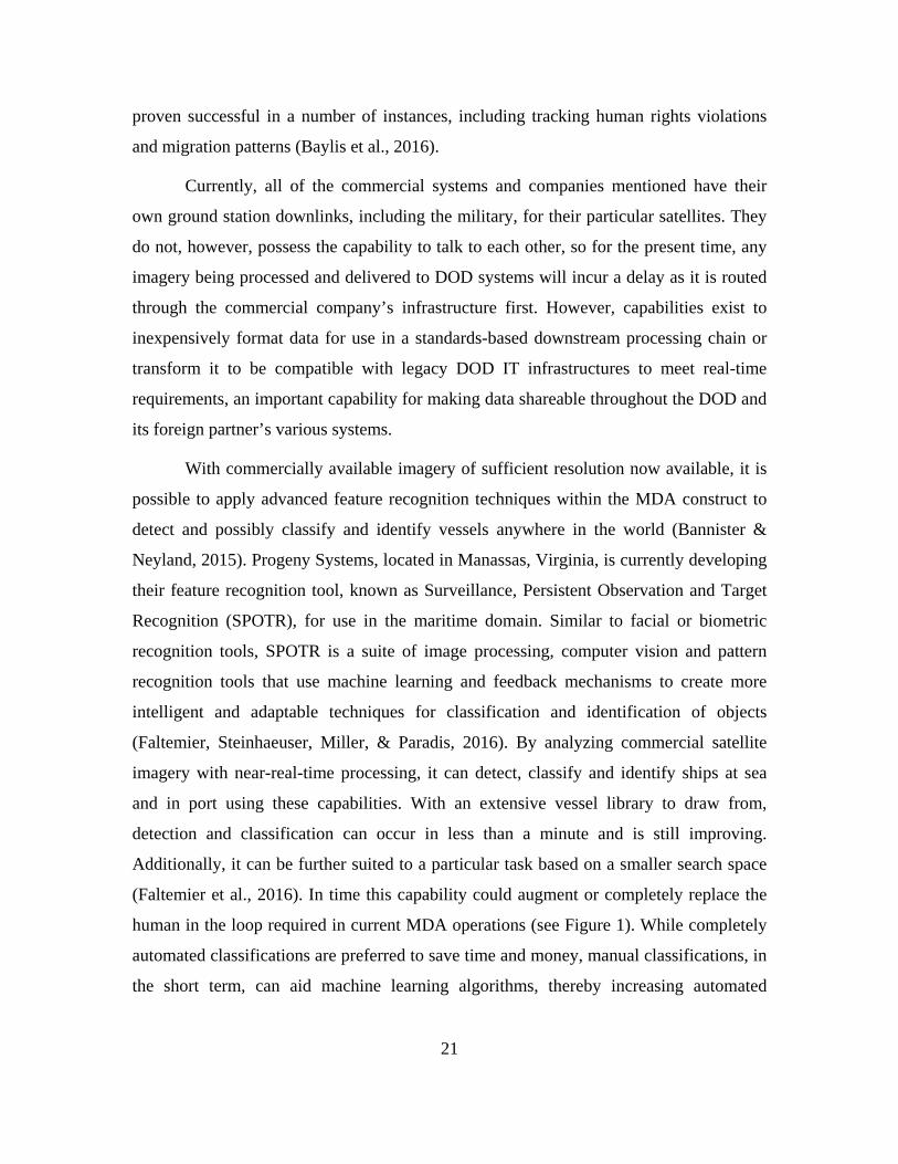
cost in the long run and should not be dismissed.
SPOTR Supporting Product Generation. Source: Figure 1. Faltemier et al. (2016).
Beyond imagery and vessel tracking systems there are opportunities for other
sources to be incorporated into the COP as they become available. Some of these
technologies are currently being tested while others are still in development. These data
sources include passive sonar detection, coastal radar and full motion video. As these
data sources become available they can be fused into the COP via a standard, agreed
upon message format, to make it even more reliable and complete.
3. COP Display
Unifying the overarching strategy, built around these aggregate capabilities, can
produce, a comprehensive, reliable and shareable COP. How the information is displayed
on the COP is very important. It will determine the usability and adoptability to the user.
This is one of the limiting factors in the current MDA architecture. Due to the nature of
how data is collected, received and/or stored, it is often only displayable via classified
applications. There are numerous COTS unclassified COP applications available, such as
Sensor Island, iCommand and probably most well-known, Google Earth (Naval
Postgraduate School, 2013). These COP applications have non-military uses such as
Emergency Operation Centers (EOC) for wildfires or hurricane relief. Most notable and
23
applicable to this MDA strategy is SeaVision, an unclassified COP application that is
sponsored by the Office of the Chief of Naval Operations for Information Warfare
(OPNAV N2N63) and is being primarily developed by the U.S Department of
Transportation’s (DOT) Volpe Center, of Cambridge, Massachusetts, in conjunction with
the Space and Naval Warfare Systems Command (SPAWAR) Data Engineering Sciences
Center, SPAWAR Systems Center Pacific and U.S. Fleet Forces Command
(SeaVision, n.d.b).
SeaVision (n.d.b) is a web-based unclassified maritime data management and
visualization tool built with the intent to boost maritime security and build relationships
within the maritime community for Public Key Infrastructure (PKI) and non-PKI users.
SeaVision creates a common maritime picture via a Google Maps-based interface
allowing the user to see, filter and track near-real-time vessel location information as well
as receive notifications on specific VOI based on user-defined rules. Currently,
SeaVision only leverages terrestrial AIS, S-AIS, and some coastal radar systems for input
data. However, the system’s open architecture is designed to support multi-source data
giving the system room to grow and include more inputs as they become available. For
instance, testing has begun to determine if EO, full motion video and SAR imagery track
data can be supported within the architecture. Most importantly, SeaVision is adopting
and implementing the maritime data exchange formats described in the National MDA
Architecture Plan and the National Information Exchange Model (NIEM)-Maritime
(SeaVision, n.d.b). Any organization complying with these predefined user attributes and
security controls will be able to access and manage the maritime information sharing
environment and NIEM-compliant maritime data (Tweed-Kent, 2014).
Ultimately, SeaVision is an attractive application because it not only provides
situational awareness, but it can be automated to provide a user or group of users with
alerts based on a variety of conditions or filters that allows the user to better manage their
time and energy. Though current capabilities only allow the embedding and fusing of
cooperative and EO derived tracks, the potential to fully exploit this capability is
promising. Incorporating non-cooperative tracking capabilities, such as the unclassified
EO and SAR satellite data, into the system means that the SeaVision COP can be
24
complete and accurate for all authorized users with access. With user-defined options for
source selection, display data and alerts, the system is extremely flexible making it easily
adoptable by any COCOM to build a COP specific to their mission sets and AOR
concerns. Further, as a web-based application, there is no requirement for additional
hardware or equipment installations.
C. IMPLEMENTATION
No matter the tools that are used to develop this new unclassified operational
capacity, implementing this new process will face significant challenges. Users are often
critical of change. Effective testing and proof of concept will be required to ease the
transition process from the current stove-piped MDA systems to the theoretical
architecture and infrastructure required to meet current and future national interests and
MDA policy. The challenges and benefits, along with their effects on the relationships
within the enterprise, will need to be clearly defined to facilitate a smooth transition from
the old processes to the new unclassified CONOPS. A successful proof of concept will
assure stakeholders that the new process is well thought out and the benefits will
outweigh the challenges to implementation.
D. CHAPTER SUMMARY
MDA can provide a significant strategic advantage if information can be collected
and disseminated quickly and effectively. To date, there are no completely unclassified
means in which this can accomplished. However, the recent advances in COTS ISR
technology potentially make this possibility a reality. The challenge lies in utilizing these
new capabilities in a cohesive, low-cost, easy-to-use way that all interested agencies and
partners can leverage. In order to determine a viable unclassified solution to MDA, the
current methods must be deconstructed to gain an understanding of their flaws and how
to best address them.
25
III. RESEARCH METHODOLOGY
A. UNDERSTANDING THE CURRENT SOLUTIONS
The purpose of this thesis is to establish a CONOPS that will provide an
unclassified maritime COP with the capability to produce near-real-time shareable
information from which all authorized interested parties can benefit. The first step in
creating this new process is to address how MDA is currently achieved and by what
means. From there, it can be determined where the gaps exist and properly implement
solutions to bridge those gaps. Due to varying threats and concerns around the world, the
current MDA processes are broad in scope. This is the result of the many socio-technical
aspects of the commanders, staff and information systems involved. To address this
complexity, this chapter provides a high-level systematic analysis of current systems in
place that provide MDA, the gaps that exist and finally, the improvements that can be
employed to better the current process.
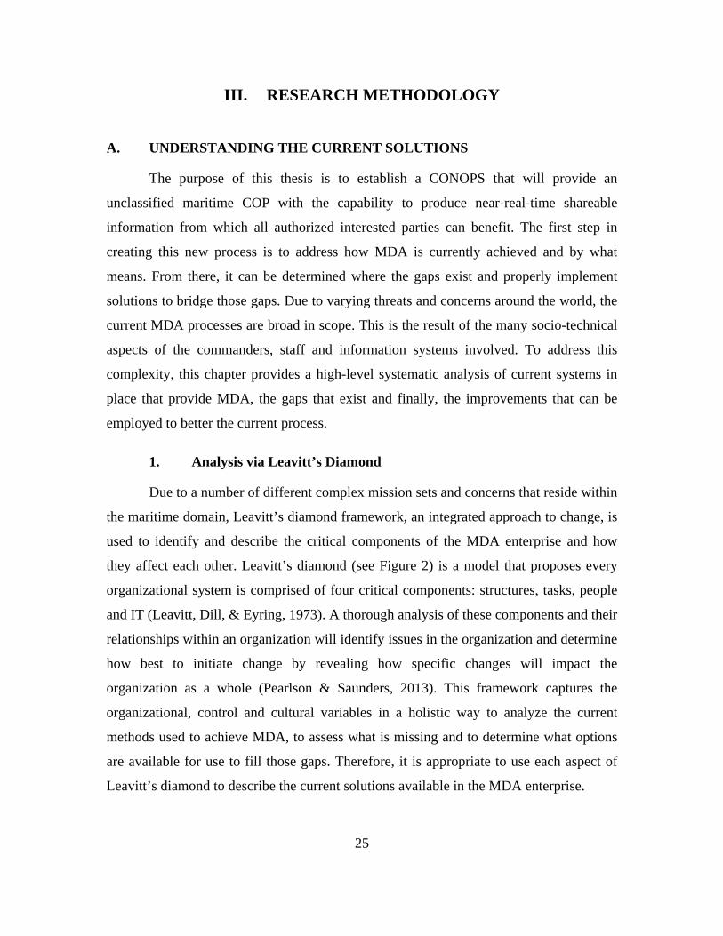
1. Analysis via Leavitt’s Diamond
Due to a number of different complex mission sets and concerns that reside within
the maritime domain, Leavitt’s diamond framework, an integrated approach to change, is
used to identify and describe the critical components of the MDA enterprise and how
they affect each other. Leavitt’s diamond (see Figure 2) is a model that proposes every
organizational system is comprised of four critical components: structures, tasks, people
and IT (Leavitt, Dill, & Eyring, 1973). A thorough analysis of these components and their
relationships within an organization will identify issues in the organization and determine
how best to initiate change by revealing how specific changes will impact the
organization as a whole (Pearlson & Saunders, 2013). This framework captures the
organizational, control and cultural variables in a holistic way to analyze the current
methods used to achieve MDA, to assess what is missing and to determine what options
are available for use to fill those gaps. Therefore, it is appropriate to use each aspect of
Leavitt’s diamond to describe the current solutions available in the MDA enterprise.
26
Leavitt’s diamond. Adapted from Leavitt et al. (1973). Figure 2.
a. Structure Analysis
The first aspect of the Leavitt diamond is structure. This includes the hierarchical
structure as well as the relationships and communication patterns throughout the
organization (Leavitt et al., 1973). The USN is the lead agency responsible for achieving
maritime superiority at home and abroad where national interests are affected. The
expansive nature of the global maritime environment coupled with a dwindling defense
budget prevents the USN and supporting agencies from being able to physically monitor
all of the world’s waterways continuously. Currently, monitoring and tasking in the MDA
arena fall to each of the COCOMs separately to operate as they see fit within their AOR.
They each have different concerns and mission requirements. This has led to various
information silos, both classified and unclassified, that do not easily share information of
interest with other COCOMs, U.S. agencies and foreign partners. To best achieve
effective global MDA, a comprehensive COP is required so the United States can, at a
minimum, proactively monitor vessels throughout the world virtually and take action
when and where as necessary.
b. People Analysis
Another aspect of Leavitt’s framework is people, which can be characterized as
individual actors, subunits, or organizations as a whole. It is not just the users of the
27
processes and data, but their skills, productivity and efficiency to address their COCOMs
needs and concerns (Leavitt et al., 1973). Each of the numbered fleet commanders have
different concerns within their particular maritime AOR, and therefore, require different
MDA information to meet their needs. For example, Commander, Fourth Fleet’s main
concern in the waters around South America where their primary concern is the
trafficking of humans, weapons and illicit narcotics. Commander Sixth Fleet (C6F),
whose AOR focus is the Mediterranean Sea and along the African coast where they are in
a constant battle against piracy, illegal fishing and immigration. Commander Fifth Fleet
(C5F), concerned with the Indian Ocean and the Persian Gulf, shares many of these
concerns as well as operating as an active participant in the War on Terror. Finally, C7F
is focused on a wide array of threats including the proliferation of nuclear weapons,
Chinese aggression and sovereignty disputes in and around the SCS, as well as illegal,
unlicensed and unregulated fishing. Based on different mission sets and requirements,
their budgets and manpower resources vary greatly. Regardless of the perceived area of
focus and the resources they employ, the ability to achieve MDA is imperative to
recognizing and prosecuting those threats before they can do irreparable damage. As the
operational sponsor to this research, C7F’s command and control structure was given
primary focus. However, recognizing the common need and taking into account that each
COCOM has a different perspective, operational requirements requiring different skill
sets and relationships with other agencies and countries, will play a large part in finding
an acceptable global solution.
As discussed, C7F is not as affected by terrorism or everyday immigration issues
like the other COCOMs. Because C7F’s concerns, such as Chinese aggression and island
building activities, tend to reveal themselves slowly over time, innovation has not
occurred as rapidly. C7F still maintains a cold war type posture using old cold war tactics
to monitor China and other South East Asian threats. Due to the sheer size and dynamic
nature of their AOR, C7F lacks the time and resources to focus on MDA as much as they
would like. This results in a reactive approach to MDA. Their personnel are doing the
work manually via separate computer systems to analyze incoming data and spreadsheets
to track it. The information they collect must then be integrated or fused with existing
28
disparate technologies. Currently, derived MDA data is uploaded manually for delivery
to the IC via the Joint Worldwide Intelligence Communications System (JWICS). This
limited data exchange is cumbersome and sometimes inaccurate causing unnecessary
delays. JWICS is a classified intelligence system so when the information is used,
regardless of classification level prior to input, it retains the classification of the JWICS
network and must go through a cross-domain solution, or a complicated declassification
process, to be shared. These aspects combined with technology limitations across country
and agency boundaries create a sluggish MDA environment which limits C7F’s ability to
operate proactively.
c. Task Analysis
The tasks, or processes and goals, of achieving MDA are primarily a command
and control function that requires a socio-technical solution. The goal is a complete view
of the battlespace and how well that goal is achieved is crucial to operating effectively
within it. For this thesis, the maritime domain is the defined battlespace that concerns the
USN with regards to MDA. While commanders are faced with many different mission
requirements within this complex battlespace, all require some aspect of command and
control. The commander’s ability to perform command and control is constrained by the
speed in which they can cycle through the OODA loop. This concept is pivotal in the
achievement of any given mission set, especially MDA (Hutchins et al., 2008). Figure 3
is an example of an MDA workflow, representing C5F, which accurately depicts the
immense complexity of command, control, communications, computers and intelligence,
surveillance and reconnaissance (C4ISR) processes involved in MDA and how it relates
to the entities and people involved. Typically, commanders and their staff rely on various
data sources, processes and displays to gather information and build situational awareness
within their AOR. This situational awareness is usually viewed via some COP which
supports the first two aspects of the OODA loop, observe and orient. Not only is it
important to appreciate that interactions like these take place, it is also key to
understanding what questions are being asked and how they are answered to improve the
process.
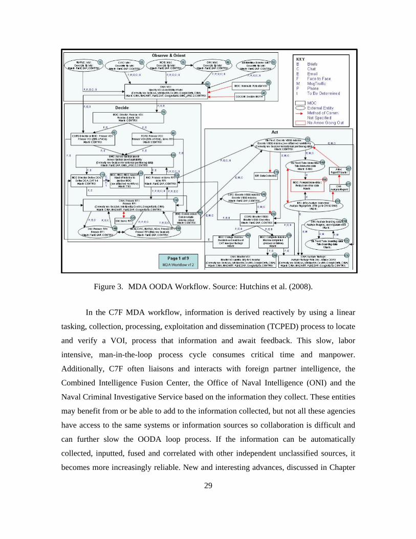
29
MDA OODA Workflow. Source: Hutchins et al. (2008). Figure 3.
In the C7F MDA workflow, information is derived reactively by using a linear
tasking, collection, processing, exploitation and dissemination (TCPED) process to locate
and verify a VOI, process that information and await feedback. This slow, labor
intensive, man-in-the-loop process cycle consumes critical time and manpower.
Additionally, C7F often liaisons and interacts with foreign partner intelligence, the
Combined Intelligence Fusion Center, the Office of Naval Intelligence (ONI) and the
Naval Criminal Investigative Service based on the information they collect. These entities
may benefit from or be able to add to the information collected, but not all these agencies
have access to the same systems or information sources so collaboration is difficult and
can further slow the OODA loop process. If the information can be automatically
collected, inputted, fused and correlated with other independent unclassified sources, it
becomes more increasingly reliable. New and interesting advances, discussed in Chapter
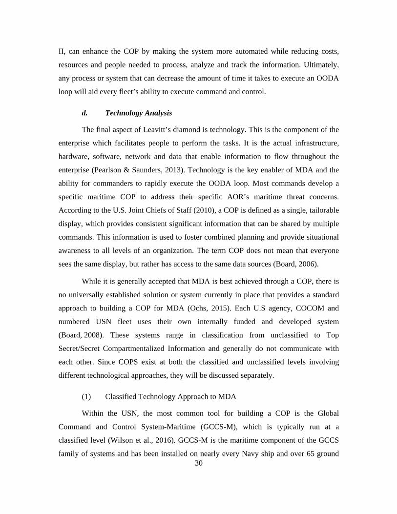
30
II, can enhance the COP by making the system more automated while reducing costs,
resources and people needed to process, analyze and track the information. Ultimately,
any process or system that can decrease the amount of time it takes to execute an OODA
loop will aid every fleet’s ability to execute command and control.
d. Technology Analysis
The final aspect of Leavitt’s diamond is technology. This is the component of the
enterprise which facilitates people to perform the tasks. It is the actual infrastructure,
hardware, software, network and data that enable information to flow throughout the
enterprise (Pearlson & Saunders, 2013). Technology is the key enabler of MDA and the
ability for commanders to rapidly execute the OODA loop. Most commands develop a
specific maritime COP to address their specific AOR’s maritime threat concerns.
According to the U.S. Joint Chiefs of Staff (2010), a COP is defined as a single, tailorable
display, which provides consistent significant information that can be shared by multiple
commands. This information is used to foster combined planning and provide situational
awareness to all levels of an organization. The term COP does not mean that everyone
sees the same display, but rather has access to the same data sources (Board, 2006).
While it is generally accepted that MDA is best achieved through a COP, there is
no universally established solution or system currently in place that provides a standard
approach to building a COP for MDA (Ochs, 2015). Each U.S agency, COCOM and
numbered USN fleet uses their own internally funded and developed system
(Board, 2008). These systems range in classification from unclassified to Top
Secret/Secret Compartmentalized Information and generally do not communicate with
each other. Since COPS exist at both the classified and unclassified levels involving
different technological approaches, they will be discussed separately.
(1) Classified Technology Approach to MDA
Within the USN, the most common tool for building a COP is the Global
Command and Control System-Maritime (GCCS-M), which is typically run at a
classified level (Wilson et al., 2016). GCCS-M is the maritime component of the GCCS
family of systems and has been installed on nearly every Navy ship and over 65 ground
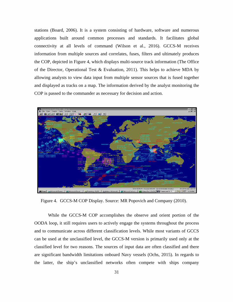
31
stations (Board, 2006). It is a system consisting of hardware, software and numerous
applications built around common processes and standards. It facilitates global
connectivity at all levels of command (Wilson et al., 2016). GCCS-M receives
information from multiple sources and correlates, fuses, filters and ultimately produces
the COP, depicted in Figure 4, which displays multi-source track information (The Office
of the Director, Operational Test & Evaluation, 2011). This helps to achieve MDA by
allowing analysts to view data input from multiple sensor sources that is fused together
and displayed as tracks on a map. The information derived by the analyst monitoring the
COP is passed to the commander as necessary for decision and action.
GCCS-M COP Display. Source: MR Popovich and Company (2010). Figure 4.
While the GCCS-M COP accomplishes the observe and orient portion of the
OODA loop, it still requires users to actively engage the systems throughout the process
and to communicate across different classification levels. While most variants of GCCS
can be used at the unclassified level, the GCCS-M version is primarily used only at the
classified level for two reasons. The sources of input data are often classified and there
are significant bandwidth limitations onboard Navy vessels (Ochs, 2015). In regards to
the latter, the ship’s unclassified networks often compete with ships company
32
communications and the Non-Classified Internet Protocol Router Network (NIPRNET)
administrative processes, limiting remaining bandwidth for operational and tactical uses.
Alternatively, higher classification networks have a higher capacity because they are
mission essential, and therefore, given more bandwidth priority. SIPRNET networks
ensure that the minimum bandwidth requirements for GCCS-M are met (MR Popovich
and Company, 2010). The classification of GCCS-M limits the ability to share
information among partner nations and agencies that do not have a direct connection to
the system.
(2) Unclassified Technology Approach to MDA
Realizing that data contained within an unclassified COP is easier to share, steps
have been taken to utilize more unclassified methods to produce usable MDA
information. For more than a decade, the DOD has taken steps to exploit COTS solutions
to create and leverage unclassified data sources which has resulted in numerous
unclassified COP applications being developed (Board, 2008). Some of these products
have been developed for the individual use of services, agencies and/or numbered fleets
based on their specific operational needs. For example, U.S Northern Command uses the
Situational Awareness Geospatial Enterprise and Risk assessment, Planning and Incident
Decision Support as unclassified COP (U.S. Joint Chiefs of Staff, 2015). For years, U.S.
Southern Command used the Cooperating Nations Information Exchange System, but has
recently transitioned to the Cooperative Situational Information Integration system
(CSII), demonstrated in Figure 5, as a method for achieving MDA in Central and South
America (Marina, 2013). C6F has had success using the previously mentioned SeaVision
application with their African partner nations to track and combat illegal fishing
(McLean, 2013).
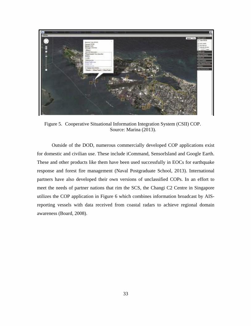
33
Cooperative Situational Information Integration System (CSII) COP. Figure 5. Source: Marina (2013).
Outside of the DOD, numerous commercially developed COP applications exist
for domestic and civilian use. These include iCommand, SensorIsland and Google Earth.
These and other products like them have been used successfully in EOCs for earthquake
response and forest fire management (Naval Postgraduate School, 2013). International
partners have also developed their own versions of unclassified COPs. In an effort to
meet the needs of partner nations that rim the SCS, the Changi C2 Centre in Singapore
utilizes the COP application in Figure 6 which combines information broadcast by AIS-
reporting vessels with data received from coastal radars to achieve regional domain
awareness (Board, 2008).
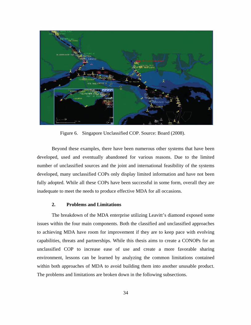
34
Singapore Unclassified COP. Source: Board (2008). Figure 6.
Beyond these examples, there have been numerous other systems that have been
developed, used and eventually abandoned for various reasons. Due to the limited
number of unclassified sources and the joint and international feasibility of the systems
developed, many unclassified COPs only display limited information and have not been
fully adopted. While all these COPs have been successful in some form, overall they are
inadequate to meet the needs to produce effective MDA for all occasions.
2. Problems and Limitations
The breakdown of the MDA enterprise utilizing Leavitt’s diamond exposed some
issues within the four main components. Both the classified and unclassified approaches
to achieving MDA have room for improvement if they are to keep pace with evolving
capabilities, threats and partnerships. While this thesis aims to create a CONOPs for an
unclassified COP to increase ease of use and create a more favorable sharing
environment, lessons can be learned by analyzing the common limitations contained
within both approaches of MDA to avoid building them into another unusable product.
The problems and limitations are broken down in the following subsections.
35
a. Shareability and Disclosure Problems
The most notable issue with current COP processes is that they do not produce
information in a way that can be easily shared. As discussed in the previous section, the
primary system in use to build a maritime COP on the classified side is GCCS-M. GCCS-
M has been the backbone of the USN COP for nearly 30 years. It is a dated system whose
display and functionally has not kept pace with today’s technology standards thereby
limiting the user’s ability to exploit the information they receive in an effective way
(Wilson et al., 2016). GCCS-M is a hardware intensive system that is further complicated
by its mixed use of sources and displays that have different classification requirements.
On a typical USN warship, there will be multiple instances of GCCS-M running
simultaneously to accommodate various data sources and controlled space classification
requirements (Ochs, 2015). Beyond the ship, data sharing conditions are subject to
various bilateral and multilateral agreements and the geopolitical conditions of coalition
partners. This may require the vessel to run separate instances of GCCS-M COPs at
various classification levels for each participant. For example, if Japan and South Korea
are participating in an exercise, a USN ship may need to run an instance of GCCS-M
releasable to Japan and GCCS-M releasable to South Korea because the two countries
have entered into separate bilateral agreements with the United States. This is just a small
example, but communication complications only increase as the number of parties
involved increases. Adding to the complication, each additional instance of a COP
requires extra hardware, manpower and bandwidth to run increasing the potential for
human error, system failures and breaches of sensitive information. To solve the
communication and classification issues, some systems use replication and duplication
approaches, but often these techniques may overwhelm or confuse the user with excess
unnecessary information. Modernization and increased system automation are essential.
b. Lack of Automation
GCCS-M does provide situational awareness to the commander. However, in the
age of highly advanced computers, big data and machine learning, GCCS-M lacks the
automation most users would expect. At its most basic premise, GCCS-M essentially
36
tracks and maps the input data requested by the users (Wilson et al., 2016). However,
GCCS-M is prone to data inaccuracies which require extensive oversight and upkeep on
the part of watch standers. Consistent track correlation and picture maintenance through
diligent housekeeping is required (Ochs, 2015). As a system of systems, GCCS-M has
over 75 inputs (Wilson et al., 2016). These inputs are not always fused which creates
unnecessary duplication which clutters the display (Ochs, 2015). For example, when
multiple ships, sensors, or systems all report data on the same VOI, it is not always
automatically correlated and fused. This creates multiple tracks relating to the same VOI
to appear on the COP and it is incumbent upon the user to actively manage the tracks on
the picture (Ochs, 2015). Additionally, some inputs just indicate that something is present
in an AOI with no amplifying information. The analyst has to then take extra steps to try
and determine what is present and if it is important. The track management task is
extremely time-consuming and if not done correctly will give the commander an
inaccurate picture of reality. As a result, utilizing GCCS-M, and similar systems, to
produce a usable COP is a complicated process, which requires extensive user training to
become proficient (Board, 2006).
c. Reliability
The biggest issue with unclassified approaches in building an effective COP is the
lack of unclassified data sources and processing capabilities. Most unclassified COPs rely
on AIS and coastal radar inputs. While AIS is a profound advancement in maritime safety
and security, it has significant weaknesses. As discussed in Chapter II, not every vessel is
required to use AIS and even if it does, the reporting information that an AIS subscriber
can enter is completely discretionary. There is little standard or regulatory oversight as to
what data is entered in the AIS transponder onboard the vessel so false information can
easily be transmitted. Finally, the use of AIS, and similar reporting services, is subject to
the crew. It is a known phenomenon that ship captains frequently turn off their AIS
terminals when they are in an area known for piracy to protect their crew and cargo
(Balduzzi et al., 2014). The use of satellite imagery has also been sparingly used, but to
date, it can only report the presence of an object, but not generally who or what it is,
thereby creating more work for the user vice less. Coastal radar, as a standalone system,
37
does produce usable tracks, however, the system has limited range and the tracks must be
correlated.
d. Lack of Adoption
In order to mitigate the issues that agencies have sharing the information they
acquire, many have turned to COTS products to try and replicate the classified COPs on
the unclassified side. However, as Leavitt’s diamond suggests, with a change in structure
and tasks, other components will need to change as well. All stakeholders must buy into
the new system for it to be successful. Those affected by the system have to gain value
from it and trust the system. If the system is not easy to use or reliable, the user will not
adopt it. And to date, the attempts to build an unclassified COP have not been fully
adopted for these reasons and continue to be only utilized when needed. For instance, the
Computer-Assisted Maritime Threat Evaluation System (CAMTES), which gained the
interest of some commanders in specific AORs, was eventually discontinued for a lack of
sustainment funding (McLean, 2013). Because CAMTES and programs like this have
been abandoned before their potential was fully realized, new programs are met with
caution and disinterest by fleet commanders who do not want to waste resources
integrating something that is incomplete or not fully funded.
Another adoptability issue stems from a lack of communication with regard to
unclassified COP best practices. As mentioned previously, the COCOMs are each using
disparate systems. If one common system was in place, funding could be streamlined and
the COP could be fully developed and sustained over time. Bottom line is that
unclassified approaches to achieve MDA have lacked staying power because they are not
programs of record and tend to be incomplete due to a lack of maturity and little follow
through.
Based on the analysis of the MDA enterprise using Leavitt’s diamond framework,
changes are required to meet the evolving global needs to effectively manage and utilize
relevant information to achieve effective MDA. It is important to note, as Leavitt’s
diamond suggests, the gaps are threaded through all four components of the enterprise
with a limitation in one affecting the others’ ability to succeed. Analysis suggests that the
38
recent advances in ISR technology, if properly implemented, will provide the most
significant and positive impact on all components within the enterprise. The primary
issues with producing an effective COP include communication difficulties that are the
result of stove-piped systems that cannot communicate, difficulty creating a
comprehensive picture due to cumbersome, resource intensive processes and an inability
to reach across organizational boundaries with the information that is gathered. Taking
advantage of newer COTS products could provide solutions to these shortcomings.
However, changes to technology and the related MDA processes, will affect all the other
components of the enterprise and they must be continually evaluated as new products and
processes are implemented.
B. DEVELOPING THE TO-BE MODEL
Based on the general issues discovered during analysis, discussions were held
with leadership and operators from various fleets around the world to determine the
specific issues they have conducting MDA in their AOR. Their current challenges to the
MDA process are many and varied, but a lot of common themes emerged that were
similar to the results of our initial analysis. First and foremost, there is a need for a
simpler, user-friendly MDA process that enhances information sharing capabilities. Also,
there is reluctance to operate outside of classified systems. Users agreed that attempts to
operate at a purely unclassified level have proven expensive and time-consuming.
Furthermore, regardless of the systems in use, there is a general lack of resources, money,
manpower and time to be able to conduct MDA at a level that would be advantageous, so
MDA is often not the priority. It is also difficult to include national and foreign partners
from a both a technical and policy standpoint. Ultimately, if the way MDA is done is
going to be changed and accepted it has to work on board vessels as well as in command
centers. Due to the constraints of vessels, the new operational method will need to be low
bandwidth, low cost and easy to use and, above all else, the data needs to remain
unclassified to provide actionable, shareable information in a timely and usable manner.
With these challenges in mind, this research attempts to determine what emerging
technologies could be used to improve MDA at the operational level in a way that not
39
only meets the needs of the warfighter, but is beneficial and convenient enough to be
adopted. The CONOPS proposed attempts to automate the detection, classification,
identification of VOIs from source to display for authorized users to access when and
how they need it. For this process to work it must be able to successfully identify and
track vessels on an unclassified application incorporating new and historical data fused
from multiple sources. This should reduce the overall time required for an intelligence
analyst to complete routine MDA tasks by automating the process of detection,
classification and identification with multi-source correlation to increase confidence and
trust in the system. It could also take advantage of other useful automated capabilities to
decrease the time an analyst spends searching for information. These capabilities would
include alerts and warnings based on anomaly detection set by the user with a low trade-
off between false alarms and missing critical data, (e.g., boundary violations and user-
defined management tasks and filters). Ultimately, it provides a real-time comprehensive
COP to support proactive decision making at the operational and tactical levels with the
capability to collaborate and share information between all interested parties.
In order to make this process a reality, numerous unclassified capabilities
discussed in Chapter II were vetted for validity in this model. Numerous COTS
capabilities exist that can provide unclassified data for input into the COP that are able to
detect and identify cooperative VOI, such as AIS, LRIT, and VMS. Non-cooperative
targets can be detected and tracked via coastal radar systems and image/video downloads
from SAR and EO satellite sensors. Quick and effective capture of this information is
required to useful. To accomplish this, data processing and analytics will need to occur
near-real-time and with a high rate of success. Finally, the data will need to be displayed
in a cohesive manner via an easy to use application. The concept behind this CONOPS
does not drastically differ from other unclassified COPs that have been suggested in the
past with one exception. This CONOPS aims to utilize the commercial satellite imagery
already available coupled with advanced feature recognition software to derive tracks in
conjunction with numerous other unclassified data sources. This data will populate a
COP display that leverages an extremely automated and user-friendly interface.
40
1. CONOPS Vision
The overall principle of this CONOPS is to provide a process that can produce an
unclassified COP to achieve effective MDA. It is built to provide analysts and decision
makers with high reliability and automation in a way that is tailorable to an
organization’s specific needs. The vision is twofold. First, the concept provides a scalable
platform to add and change unclassified data source inputs as ISR technology evolves
over time. Second, the process is automated to the maximum extent possible to reduced
manpower workload. This CONOPS provides a tailorable and filterable system that will
alert analysts when certain user-specified criteria are met. For instance, the user can
request an alert or warning when vessels of certain types or from specific countries or
origins leave port, transit specific areas, or arrive at designated locations.
The CONOPS is broken down into three basic system components, data sources,
processing and display. Figure 7 depicts the initial intended COTS systems proposed and
how they interact. Data sources will include any standalone system that can generate data
within the maritime domain, specifically in regards to cooperative and uncooperative
vessels. The data produced will then be downloaded and processed as necessary with
relevant information being sent to a correlator/fuser. Once fused, the information is stored
in the COP database where it can be accessed via queries from the user’s display
interface as needed.
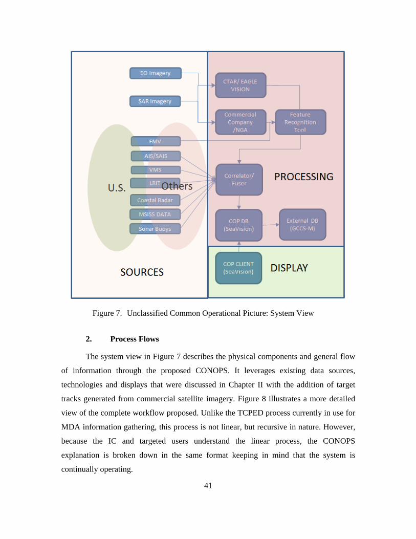
41
Unclassified Common Operational Picture: System View Figure 7.
2. Process Flows
The system view in Figure 7 describes the physical components and general flow
of information through the proposed CONOPS. It leverages existing data sources,
technologies and displays that were discussed in Chapter II with the addition of target
tracks generated from commercial satellite imagery. Figure 8 illustrates a more detailed
view of the complete workflow proposed. Unlike the TCPED process currently in use for
MDA information gathering, this process is not linear, but recursive in nature. However,
because the IC and targeted users understand the linear process, the CONOPS
explanation is broken down in the same format keeping in mind that the system is
continually operating.
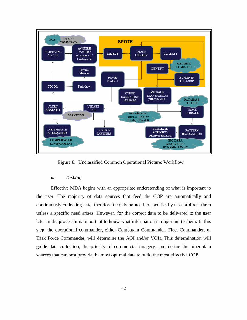
42
Unclassified Common Operational Picture: Workflow Figure 8.
a. Tasking
Effective MDA begins with an appropriate understanding of what is important to
the user. The majority of data sources that feed the COP are automatically and
continuously collecting data, therefore there is no need to specifically task or direct them
unless a specific need arises. However, for the correct data to be delivered to the user
later in the process it is important to know what information is important to them. In this
step, the operational commander, either Combatant Commander, Fleet Commander, or
Task Force Commander, will determine the AOI and/or VOIs. This determination will
guide data collection, the priority of commercial imagery, and define the other data
sources that can best provide the most optimal data to build the most effective COP.
43
b. Collection
Once the AOI and VOI are clear, data can be appropriately acquired and
eventually displayed. One of the main benefits of this process is that data is being
collected continuously regardless of the AOI and VOI, but with priorities established, the
system can concentrate on the areas and vessels of most concern and archive the
remaining data for use as needed. Numerous unclassified sources of data have already
been successfully implemented in building COPs, including AIS, LRIT, VMS, coastal
radars, sonar buoys and EO/SAR satellite imagery. This data is generated by both United
States and foreign partner systems. But they have not yet been used in a way that builds a
unique and comprehensive COP. All these inputs need to be compared and fused to
create a system that is highly reliable to build user trust. The greatest gain to the system
will be the addition of high-resolution commercial imagery. This will create an additional
layer of track information to the system, ideally without user input. The National
Geospatial-Intelligence Agency (NGA) already has contracts with a number of
companies producing such imagery, including DigitalGlobe, Terra Bella, Black Sky and
Planet Labs. These contracts provide the NGA, the DOD’s primary broker for
commercial satellite imagery, with access to all of their collected images. Due to the size
and quality of the imagery and the amount of data they produce, it has not been feasible
for use in a COP to date.
While commercial imagery has not yet been established as a data point in a COP,
the use of this imagery has proven extremely beneficial to MDA operations. For rapid
data acquisition, the Navy’s process called Coalition Tactical Awareness and Response
(CTAR) has been leveraged. CTAR is designed to serve as a tactical system giving a
theater commander direct access to satellite systems to proactively collect and process
SAR and EO imagery. The images taken are directly downloaded to a mobile ground
station positioned near the theater of operations where they can be analyzed manually on
the spot (Ochs, 2015). While this process is quicker than waiting for the satellite to pass a
specific spot where it is in range to download its data, which could be hours or days later,
it is still not a perfect system. Gaining access to task a satellite for a specific mission and
maintaining and moving a mobile ground station is extremely expensive. If the massive
44
library of data that the commercial imagery companies produce can be leveraged and
analyzed automatically, the CTAR system could be prioritized for very specific, rapid
acquisition needs. The information gained from those missions will benefit from the
additional data that can be acquired from this CONOPS as well. However, CTAR has
proven the need and successful use of commercial satellite in an operational capacity.
For this CONOPS, the more these commercial companies continue to launch
increasingly advanced imaging satellites, the more the associated imagery library
continues to expand, covering more of the globe with greater persistency. The images
collected from these companies, or directly via satellite tasking, will be automatically
ingested via downlink into the processing software. Once downloaded, it can be
analyzed via highly advanced computer processing and algorithms to detect, classify and
identify vessels and input into the unclassified COP for all authorized users to see. This
would decrease the need for expensive and time-consuming processes to specifically task
satellites. In order to fully exploit satellite imagery, it must be quickly downloaded and
processed, to ensure the COP is as close to real-time as possible.
Finally, within this CONOPS foreign partners can be data contributors vice just
data consumers. Partner nations often have their own satellites, coastal radars, sonar
buoys and collected vessel tracking data which they can supply, with the correct
messaging format and access rights, directly into the COP. For example, the Canadian
company, MacDonald, Dettwiler and Associates, has a commercial RADARSAT
constellation of satellites that collects SAR imagery. This could easily be included as a
data source with the right data messaging formats (Ochs, 2015). This cooperation builds
trust, aids in information sharing and contributes to an even more robust picture. Once all
of the data has been collected, it will be automatically processed into information.
c. Processing
One of the biggest issues hindering the adoption of an unclassified COP is that the
data acquired requires too much time and resources for proper analysis to be considered
beneficial. A lot of manual analysis and track updating is required. This CONOPS aims
to alleviate this issue. The uniqueness of this CONOPS lies within the processing
45
capabilities which will automate a lot of the more time-consuming analysis and record
keeping steps for the user. For this CONOPS, due to the variety of input sources, multiple
types of processing occur throughout this phase. Therefore, the processing phase for
description purposes will be generalized into three categories: acquisition and transport,
feature recognition and fusion. The data from all input sources will be collected,
transmitted and processed either remotely at the data source or further down the chain
where data is correlated.
During acquisition and transport, the data from each source undergoes its own
processing at its origin. For example, commercial SAR imagery that is collected by the
Canadian RADARSAT is sent to OceanSuite, a tool which analyzes SAR imagery and
detects ships (Ochs, 2015). Likewise, remote coastal radar systems generally conduct
their own remote processing then send tracked target messages for input into the COP (J.
Stastny, personal communication, October 24, 2016). While all types of data processing
are important to and included in this CONOPS, this is not necessarily a new concept. The
most critical new addition that makes this system really work is the application of feature
recognition software to extract data from commercial satellite imagery quickly and
accurately. It provides a solution to the gap in surveillance and analysis that prevents
MDA from being truly a proactive mission.
Technological advances in computer vision and machine learning have created
feature recognition software capable of detecting, classifying and identifying non-
cooperative targets at long range. Facial and pattern recognition is already commonly
used for a variety of reasons, however, in theory, this could be leveraged in unique ways
to aid in MDA (Faltemier, et al., 2016). SPOTR, briefly discussed in Chapter II, is a suite
of image processing, computer vision and pattern recognition tools that incorporate
advanced algorithms, object detectors and machine learning to continually refine the
2D/3D models used for recognition. The more the system is used, the better it gets.
Initially, humans are in the loop to provide review and correction feedback to the system
as necessary (Faltemier et al., 2016). With time, this will take the analysis and product
creation out of the hands of the user by automatically detecting vessels in overhead
imagery, extracting its features and matching those features against known models
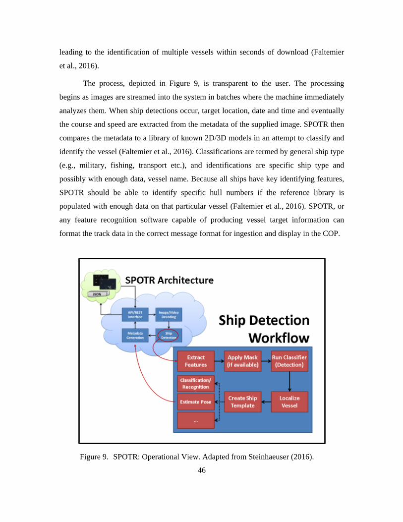
46
leading to the identification of multiple vessels within seconds of download (Faltemier
et al., 2016).
The process, depicted in Figure 9, is transparent to the user. The processing
begins as images are streamed into the system in batches where the machine immediately
analyzes them. When ship detections occur, target location, date and time and eventually
the course and speed are extracted from the metadata of the supplied image. SPOTR then
compares the metadata to a library of known 2D/3D models in an attempt to classify and
identify the vessel (Faltemier et al., 2016). Classifications are termed by general ship type
(e.g., military, fishing, transport etc.), and identifications are specific ship type and
possibly with enough data, vessel name. Because all ships have key identifying features,
SPOTR should be able to identify specific hull numbers if the reference library is
populated with enough data on that particular vessel (Faltemier et al., 2016). SPOTR, or
any feature recognition software capable of producing vessel target information can
format the track data in the correct message format for ingestion and display in the COP.
SPOTR: Operational View. Adapted from Steinhaeuser (2016). Figure 9.
47
Confidence in data output is key to the success of this system. Deep machine
learning and convolutional neural networks (CNN) like Progeny’s SPOTR, are using
their proprietarily developed software and algorithms to detect, classify and identify sea-
going vessels that are present in satellite imagery, but its use in mission specific scenarios
or large real world applications is a relatively non-existent. CNN’s like SPOTR have a
known error rate of approximately 17% (Krizhevsky, Sutskever, & Hinton, 2012).
Therefore, while SPOTR has shown impressive results in testing (e.g., a false target rate
of less than 1%), if possible, blending different types of computer vision technologies
together would produce more reliable results.
Finally, data fusion is also taking place during the processing step of this
CONOPS. The resultant processed data ingested into the COP need to be aggregated,
correlated and fused. The display will still be usable without this step, but it will require a
lot of user time and input to decipher the clutter and gain actionable information. To
minimize that problem, track data is fused, sent to the COP database for storage and the
COP display is updated. The key enabler here is common data standards. In order for all
these systems to input their data into the COP, common data standards are required to
enable disparate systems to communicate and will facilitate the ultimate goals of
collaboration and interoperability. This open architecture, with agreed upon standards,
not only creates an agile and versatile system, but creates opportunities for information
sharing between parties that were unable to contribute in the past. All authorized users
will now be able to contribute thereby building a more comprehensive and reliable COP.
In SeaVision, the recommended COP application, the correlation of data is
accomplished with Rapier Fusion, a time delayed data correlator (J. Stastny, personal
communication, October 24, 2016). Rapier Fusion uses position, length/width and
heading derived data from imagery-based sources and correlates them with separately
reported electronic sources such as AIS/VMS/LRIT. The fused and correlated track now
contains information from multiple data sources and is stored in SeaVision’s database.
This database serves as the COP’s main data source. Additionally, this database and the
information contained could be accessed by SPOTR to improve and reinforce its image
model library. This process of fusion and correlation greatly enhances the confidence and
48
reliability of the system while cutting the costs, resources and people needed to process,
analyze and track the information.
The advanced identifications that SPOTR provides are extremely beneficially to
MDA and future analysis, however, it is recognized that individual ship identification is
not always possible. It should be noted that even limited ship detection information, (e.g.,
location, date and time), can provide valuable non-cooperative inputs to the COP. Theses
inputs can be fused with others if correlation data exists or to just alert the user that
something is there. Ultimately, by shifting the analysis and processing tasks to
technology, analysts and decision makers will be more productive. They can spend more
time on the important decide and act phases of the OODA loop and leave the busy work,
observe and orient, to the automated MDA system processes. This capability, enabled by
technology, and through conformance to technical standards, paves the way for all users
to be involved in the processes from collection to display. The continuous cycle of
tasking, collection and processing is constantly producing information that is present in
the COP for exploitation.
d. Exploitation
Once the data is processed and formatted, the information needs to be presented in
a way that is usable and exploitable. During this stage, the information from multiple
sources is now resident in the SeaVision database and is available for COP display, the
physical manifestation of this CONOPS. Based on the options available, SeaVision is the
display application that provided the best fit for this CONOPS (see Figure 10). SeaVision
provides a user-friendly platform which is capable of displaying a broad spectrum of
maritime information from multiple disparate sources. Most importantly, it uses the
NIEM conformant data exchange allowing it to be highly scalable as new data sources
become available. SeaVision’s web-based interface, ease of use, automation, architecture
and user tailorable features provide an excellence resource for the USN, U.S. Coast
Guard, other federal agencies and partner nations. Unlike GCCS-M, SeaVision does not
require any hardware installation or maintenance by the end-user; all processing and data
fusion occurs upstream. Additionally, it provides a multi-tiered access capability that can
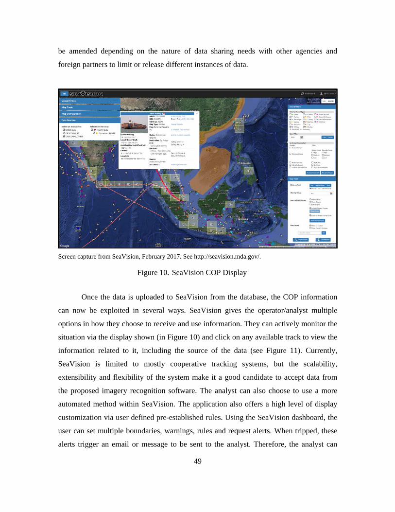
49
be amended depending on the nature of data sharing needs with other agencies and
foreign partners to limit or release different instances of data.
Screen capture from SeaVision, February 2017. See http://seavision.mda.gov/.
SeaVision COP Display Figure 10.
Once the data is uploaded to SeaVision from the database, the COP information
can now be exploited in several ways. SeaVision gives the operator/analyst multiple
options in how they choose to receive and use information. They can actively monitor the
situation via the display shown (in Figure 10) and click on any available track to view the
information related to it, including the source of the data (see Figure 11). Currently,
SeaVision is limited to mostly cooperative tracking systems, but the scalability,
extensibility and flexibility of the system make it a good candidate to accept data from
the proposed imagery recognition software. The analyst can also choose to use a more
automated method within SeaVision. The application also offers a high level of display
customization via user defined pre-established rules. Using the SeaVision dashboard, the
user can set multiple boundaries, warnings, rules and request alerts. When tripped, these
alerts trigger an email or message to be sent to the analyst. Therefore, the analyst can
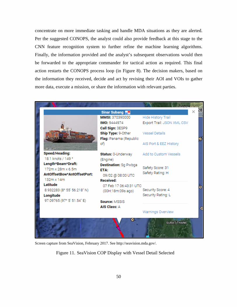
50
concentrate on more immediate tasking and handle MDA situations as they are alerted.
Per the suggested CONOPS, the analyst could also provide feedback at this stage to the
CNN feature recognition system to further refine the machine learning algorithms.
Finally, the information provided and the analyst’s subsequent observations would then
be forwarded to the appropriate commander for tactical action as required. This final
action restarts the CONOPS process loop (in Figure 8). The decision makers, based on
the information they received, decide and act by revising their AOI and VOIs to gather
more data, execute a mission, or share the information with relevant parties.
Screen capture from SeaVision, February 2017. See http://seavision.mda.gov/.
SeaVision COP Display with Vessel Detail Selected Figure 11.
51
e. Dissemination/Sharing
The final step in the TCPED process has traditionally been dissemination
however, in this CONOPS, the term sharing is used to differentiate between information
and intelligence. Information refers to just the data itself whereas intelligence is a
collection of relevant and actionable knowledge derived from information. Typically,
classified methods have been used for achieving MDA. Using this unclassified CONOPS
and display mechanism allows for an increased amount of sharable information options
not previously available to fleet commanders. Historically, the “need to know” culture
has impeded this information sharing process as intelligence professionals attempt to
safeguard their sources and methods of intelligence-gathering with often overly cautious
policies (Jones, 2007). Regardless of the culture of the intelligence communities, the
unclassified COP is needed. It allows the commander the room needed for maneuver in
the complicated geopolitical landscape. This means that while a sharing relationship of
classified information may exist between the United States and a foreign country, this
CONOPS will allow a new level of freedom in moving data between different agencies
and partnerships as needed.
In the dissemination/sharing phase, while all input data is unclassified, there is a
point at which the aggregation of information received could be considered classified and
would require some level of control. SeaVision has various levels of authorized access.
The individual commanders can determine which levels of access are appropriate for
which users for those under their command and with whom they operate. Ultimately, the
foreign disclosure officer is the local expert on classification procedures and relationships
throughout their AOR and should be consulted to determine the best course of action
regarding coalition partners in the collaborative MDA COP (Department of the Navy,
2007). Since SeaVision is a web interface and aspects of the COP can be tailored, partner
nations will only receive the data that they are authorized to view. It will be incumbent
upon their own intelligence staff to derive meaning from the data since only raw
information is passed. The end result of this CONOPS is the ability to share unclassified
information from a number of sources in the form of a tailorable, automated and
comprehensive COP. This transparent effort will go a long way in building trust with
52
foreign nations and will pay dividends with garnering foreign assistance and
collaboration.
To highlight one example, since 2014 SeaVision has been successfully used by
C6F in partnership with African countries to track and combat illegal fishing on the west
coast of Africa. By combining forces, the USN and nine nations were able to manually
use reported tracks in SeaVision with satellite imagery and coastal radar data to better
track illegal fishing vessels, levy fines and protect their national resources (Beardsley,
2014). This example of information sharing and partnership is just the first step in
achieving global MDA. Although SeaVision has not been completely adopted across the
USN, its use is growing and with the incorporation of non-cooperative tracking
capabilities via this CONOPS, the SeaVision COP will be complete and accurate.
3. Feedback Mechanisms
The USN does not have the resources or capability to cover the entire maritime
arena. Participation from foreign partners with a common interest is critical in filling
these gaps. Information sharing is built on trust and all participants should participate in
building and maintaining the picture. Providing feedback ensures that all users are able to
contribute to picture accuracy. Machine learning and computer vision technologies are
only as good as the information provided to them. They require active feedback to
consistently improve their computer algorithms to deliver accurate results. This can be
accomplished with a direct link in alert and warning emails and messages or embedded in
the track data reported on the display. If the track data is determined to be incorrect, (e.g.,
reporting a false positive), the user can directly correct the information via the link or
send the data back to SPOTR for re-analysis by their system or a human in the loop. This
process, where all participants play an active role in building the picture, creates a culture
of trust that will build confidence in using the unclassified COP.
4. Potential Use Cases
This CONOPS, where information can be shared over a collaborative system by
different agencies whereby they can collectively observe their respective AOI, can have
immediate and far-reaching effects. The shareable COP ultimately connects all entities
53
within an operational area and results in a common understanding of the maritime
environment. Three examples of how this could be particularly useful are described in the
following subsections.
a. Time-Critical Missions
Over the years, the DOD has been involved in humanitarian assistance and
disaster recovery missions, search and rescue missions and Defense in Support of
Civilian Authorities missions where hastily formed enterprises are created and DOD is
required to share information with non-traditional partners. An unclassified CONOPS as
described in Figure 8 could have a direct impact where all entities within the affected
area can access the COP to gain or add situational awareness. This will dramatically
increase the speed and efficiency of a response by means of a highly-coordinated effort.
b. Joint Inter-Agency Task Force-South (JIATF-S)
Joint Inter-Agency Task Force-South (JIATF-S) has a long history of
multinational and interagency collaboration. It is a task force that flourishes due to the
international relationships that it has spent years establishing and maintaining. While
considerable U.S. assets have been employed in the AOR, the major key to success is the
availability and willingness of host nation end-game or law enforcement assets to
interdict narco-terrorists. Even though sharing relationships have been established, the
flow of information could be enhanced. Utilizing the technologies proposed could enable
increased host nation support by providing them improved situational awareness with
access to the unclassified COP. This additional information sharing capability enables
host nations the ability to prosecute targets without the delays in multi-step coordination
through JIATF-S.
c. Piracy
Piracy exists in many AORs. In particular, the waters off the coast of Africa are
largely ungoverned allowing piracy and other maritime crimes to occur regularly and
with impunity. Reports of these incidents have risen steadily since the turn of the century
(Till, 2016). Because of this threat, commercial ship captains frequently secure their
54
electronic tracking systems, such as AIS, for their own security to ensure that they cannot
be seen by potential harmful entities. However, with current technology, this means that
they also disappear from all vessel monitoring systems which exist for their safety. If
there is an issue and the vessel needs assistance, they will be hard to track. The
multisource correlation and data fusion tools that exist in this CONOPS will allow for
commercial vessels to be continuous tracked regardless of their AIS, VMS, or LRIT
functionality. This will enable local law enforcement to protect these mariners as well as
monitor other vessels that are exhibiting potentially nefarious profiles.
C. CHAPTER SUMMARY
This research established a CONOPS that provides a way forward in achieving
effective MDA at the unclassified level. In order to determine if the CONOPS can
provide the benefits the research suggests, it must be implemented and verified. In an
effort to demonstrate that this CONOPS will work, the process was attempted as far as
current technologies would allow. Although this CONOPS was developed to use all
sources of commercial imagery and multiple CNNs for image processing, due to the lack
of time and access to some resources, the test and evaluation was limited to archived
DigitalGlobe imagery and Progeny’s SPOTR feature recognition software. The results
were instrumental in refining the CONOPS to its final state and demonstrating the
potential of the proposed system.
55
IV. DATA ANALYSIS
A. CONOPS TEST METHODS
The goal of this thesis was to build an unclassified CONOPS strategy for use in
the MDA arena in which intelligence analysts and decision makers can gain situational
awareness, gather actionable information quickly and allow them the additional
capability to share it with other services and international partners. The CONOPSs
proposed in chapter III attempts to meet these needs via a new unclassified, low
bandwidth, low cost and easy to use operational method. For this process to work and
thereby increase the probability of adoption, it must be able to successfully identify and
track vessels via an unclassified web-based application that incorporates new and
archived track data fused from the multiple sources discussed in Chapter III. This should
reduce the overall time required for an intelligence analyst to complete routine MDA
tasks by automating the process of detection, classification and identification. Ideally, this
will include multi-source correlation and data fusion to increase confidence and trust in
the system by the users. Other useful capabilities built into the system would include user
defined management tasks, filters, warnings and alerts, such as anomaly detection and
boundary violations, with a low trade-off between missing critical data and false alarms.
Finally, it will provide a real-time comprehensive COP to support proactive decision
making at the operational and tactical levels with the capability to collaborate and share
information between all interested parties.
In order to prove that this newly developed CONOPS meets these requirements
for adoptability, an attempt to replicate the process was made using the same tools that
were suggested in Chapter III. A successful test would conclude with the detection,
classification and identification of non-cooperative vessels using the unclassified
technologies suggested. For this test, an AOI and VOIs were selected and data was
gathered from unclassified collection sources to include DigitalGlobe’s imagery and
SeaVision’s available track data. Once imagery was collected it was sent to Progeny
Systems in Manassas, Virginia for analysis by their imagery feature recognition software,
SPOTR. The primary purpose of this analysis was to test SPOTR’s ability to detect,
56
classify and identify VOIs. Simultaneously, due to delays in receiving SPOTR results,
attempts to emulate the TCPED process were conducted by processing and fusing the
data manually. Success in manual processing demonstrates that the capability to detect,
classify and identify VOIs using only unclassified means is possible. Eventually, proving
the system could be automated is the ultimate goal, but due to time constraints, the
process to make this a reality remains in development and will be discussed later.
1. Tasking
Based on C7F concerns and MDA requirements, it was determined that the
operational area of focus for the testing effort would consist of the contested islands
located in the SCS and some Chinese ports and shipbuilding yards within the Southern
Theater of China. In all, 18 key locations were identified for analysis (see Figure 12).
With the AOI and VOIs selected, the imagery collection process began. One of the key
concerns within the SCS, as described in Chapter II, surrounds the perceived aggression
of China and their island building activities. Therefore, dredgers and vessels involved in
dredging activity were selected as the VOIs.
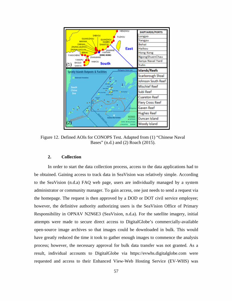
57
Defined AOIs for CONOPS Test. Adapted from (1) “Chinese Naval Figure 12. Bases” (n.d.) and (2) Roach (2015).
2. Collection
In order to start the data collection process, access to the data applications had to
be obtained. Gaining access to track data in SeaVision was relatively simple. According
to the SeaVision (n.d.a) FAQ web page, users are individually managed by a system
administrator or community manager. To gain access, one just needs to send a request via
the homepage. The request is then approved by a DOD or DOT civil service employee;
however, the definitive authority authorizing users is the SeaVision Office of Primary
Responsibility in OPNAV N2N6E3 (SeaVision, n.d.a). For the satellite imagery, initial
attempts were made to secure direct access to DigitalGlobe’s commercially-available
open-source image archives so that images could be downloaded in bulk. This would
have greatly reduced the time it took to gather enough images to commence the analysis
process; however, the necessary approval for bulk data transfer was not granted. As a
result, individual accounts to DigitalGlobe via https://evwhs.digitalglobe.com were
requested and access to their Enhanced View-Web Hosting Service (EV-WHS) was
58
granted. Access is available to anyone supporting a government mission with an active
common access card (CAC). The EV-WHS account provides access to DigitalGlobe’s
online library, which is a subset of their entire archive. This level of access allows the
user to select images, copy them to an individual DigitalGlobe user library and download
them as necessary, but limitations to specific images, geographical areas and system
features and functionality still existed. Specifically, the EV-WHS portal permitted access
to approximately 800M km2 of content, including full Global Digital Topography,
foundation GEOINT mosaics and DigitalGlobe commercial “Global Base Map” mosaics
(DigitalGlobe, n.d.b.). This was enough access to provide a wealth of images to fulfill the
image acquisition requirements for this CONOPS test.
Next, the tedious process of locating the specific AOIs was initiated. This
involved locating the specific islands and ports, then zooming in on each image set to
determine which images were desired for download and processing. Each available image
contained viewable metadata which provided information related to image properties,
such as acquisition date and time, sensor type, GSD, sun elevation and cloud cover
percentage (see Figure 13). This was useful in determining which pictures would be most
beneficial for the initial round of manual processing, and later, for Progeny’s automatic
machine-learning algorithms. The images available for each AOI differed, but each had
approximately 20–50 available ranging from 2012 to present day.
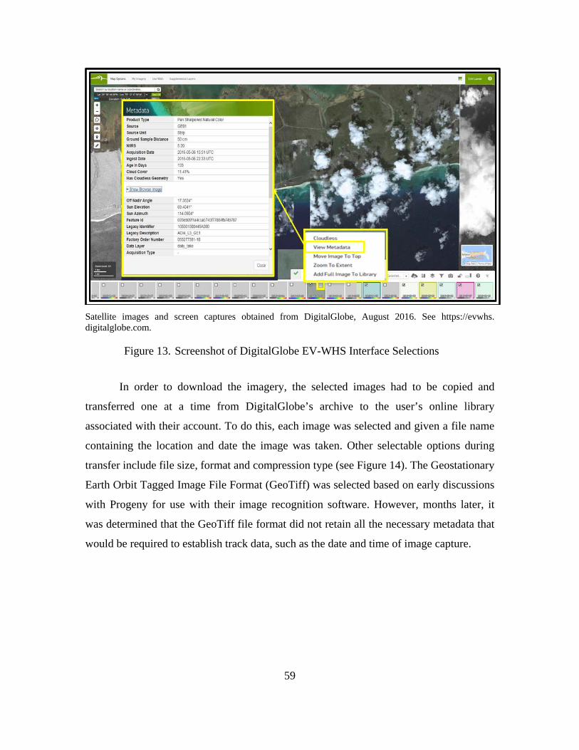
59
Satellite images and screen captures obtained from DigitalGlobe, August 2016. See https://evwhs. digitalglobe.com.
Screenshot of DigitalGlobe EV-WHS Interface Selections Figure 13.
In order to download the imagery, the selected images had to be copied and
transferred one at a time from DigitalGlobe’s archive to the user’s online library
associated with their account. To do this, each image was selected and given a file name
containing the location and date the image was taken. Other selectable options during
transfer include file size, format and compression type (see Figure 14). The Geostationary
Earth Orbit Tagged Image File Format (GeoTiff) was selected based on early discussions
with Progeny for use with their image recognition software. However, months later, it
was determined that the GeoTiff file format did not retain all the necessary metadata that
would be required to establish track data, such as the date and time of image capture.
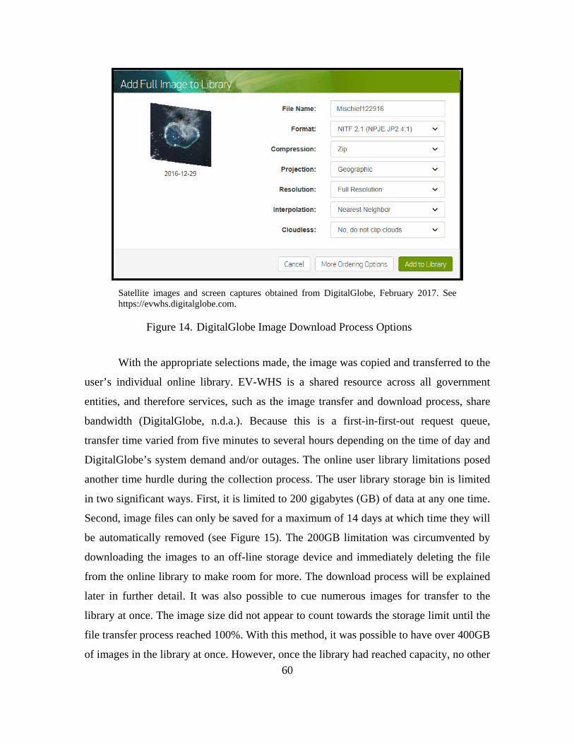
60
Satellite images and screen captures obtained from DigitalGlobe, February 2017. See https://evwhs.digitalglobe.com.
DigitalGlobe Image Download Process Options Figure 14.
With the appropriate selections made, the image was copied and transferred to the
user’s individual online library. EV-WHS is a shared resource across all government
entities, and therefore services, such as the image transfer and download process, share
bandwidth (DigitalGlobe, n.d.a.). Because this is a first-in-first-out request queue,
transfer time varied from five minutes to several hours depending on the time of day and
DigitalGlobe’s system demand and/or outages. The online user library limitations posed
another time hurdle during the collection process. The user library storage bin is limited
in two significant ways. First, it is limited to 200 gigabytes (GB) of data at any one time.
Second, image files can only be saved for a maximum of 14 days at which time they will
be automatically removed (see Figure 15). The 200GB limitation was circumvented by
downloading the images to an off-line storage device and immediately deleting the file
from the online library to make room for more. The download process will be explained
later in further detail. It was also possible to cue numerous images for transfer to the
library at once. The image size did not appear to count towards the storage limit until the
file transfer process reached 100%. With this method, it was possible to have over 400GB
of images in the library at once. However, once the library had reached capacity, no other
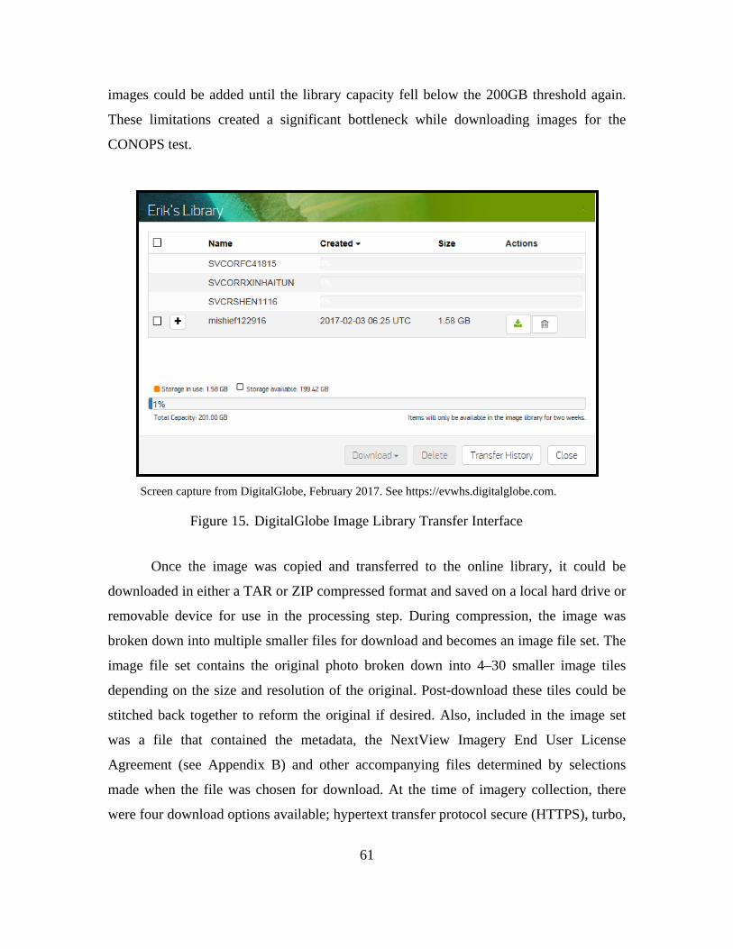
61
images could be added until the library capacity fell below the 200GB threshold again.
These limitations created a significant bottleneck while downloading images for the
CONOPS test.
Screen capture from DigitalGlobe, February 2017. See https://evwhs.digitalglobe.com.
DigitalGlobe Image Library Transfer Interface Figure 15.
Once the image was copied and transferred to the online library, it could be
downloaded in either a TAR or ZIP compressed format and saved on a local hard drive or
removable device for use in the processing step. During compression, the image was
broken down into multiple smaller files for download and becomes an image file set. The
image file set contains the original photo broken down into 4–30 smaller image tiles
depending on the size and resolution of the original. Post-download these tiles could be
stitched back together to reform the original if desired. Also, included in the image set
was a file that contained the metadata, the NextView Imagery End User License
Agreement (see Appendix B) and other accompanying files determined by selections
made when the file was chosen for download. At the time of imagery collection, there
were four download options available; hypertext transfer protocol secure (HTTPS), turbo,
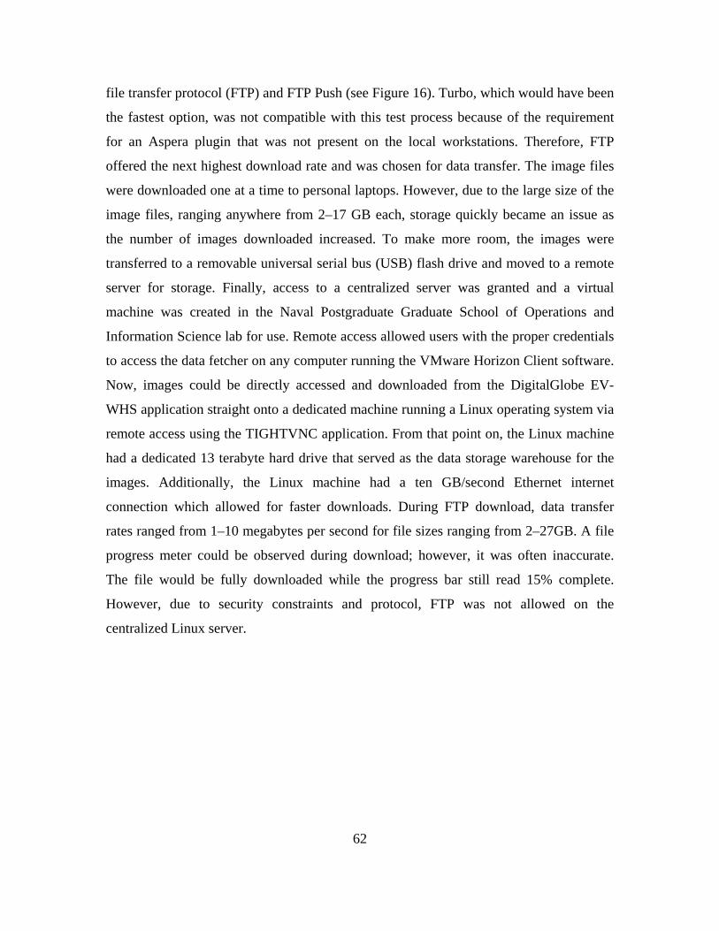
62
file transfer protocol (FTP) and FTP Push (see Figure 16). Turbo, which would have been
the fastest option, was not compatible with this test process because of the requirement
for an Aspera plugin that was not present on the local workstations. Therefore, FTP
offered the next highest download rate and was chosen for data transfer. The image files
were downloaded one at a time to personal laptops. However, due to the large size of the
image files, ranging anywhere from 2–17 GB each, storage quickly became an issue as
the number of images downloaded increased. To make more room, the images were
transferred to a removable universal serial bus (USB) flash drive and moved to a remote
server for storage. Finally, access to a centralized server was granted and a virtual
machine was created in the Naval Postgraduate Graduate School of Operations and
Information Science lab for use. Remote access allowed users with the proper credentials
to access the data fetcher on any computer running the VMware Horizon Client software.
Now, images could be directly accessed and downloaded from the DigitalGlobe EV-
WHS application straight onto a dedicated machine running a Linux operating system via
remote access using the TIGHTVNC application. From that point on, the Linux machine
had a dedicated 13 terabyte hard drive that served as the data storage warehouse for the
images. Additionally, the Linux machine had a ten GB/second Ethernet internet
connection which allowed for faster downloads. During FTP download, data transfer
rates ranged from 1–10 megabytes per second for file sizes ranging from 2–27GB. A file
progress meter could be observed during download; however, it was often inaccurate.
The file would be fully downloaded while the progress bar still read 15% complete.
However, due to security constraints and protocol, FTP was not allowed on the
centralized Linux server.
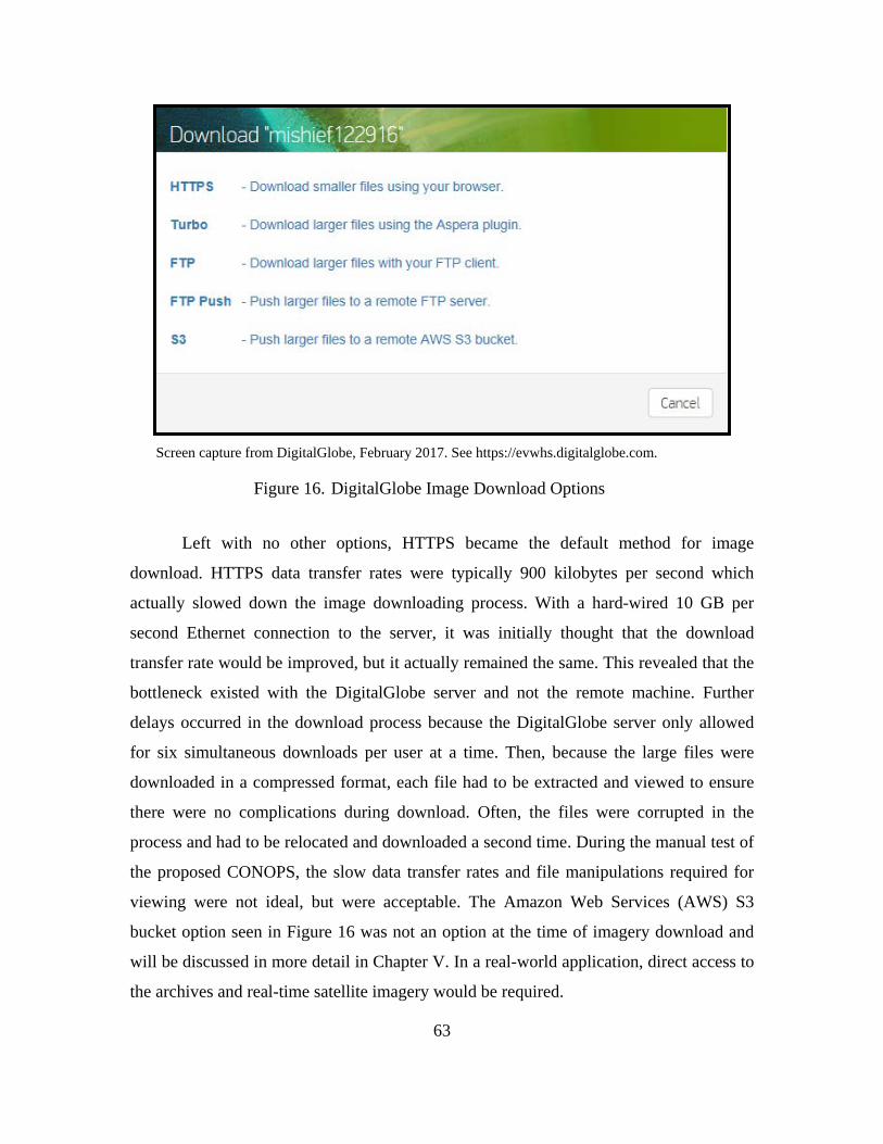
63
Screen capture from DigitalGlobe, February 2017. See https://evwhs.digitalglobe.com.
DigitalGlobe Image Download Options Figure 16.
Left with no other options, HTTPS became the default method for image
download. HTTPS data transfer rates were typically 900 kilobytes per second which
actually slowed down the image downloading process. With a hard-wired 10 GB per
second Ethernet connection to the server, it was initially thought that the download
transfer rate would be improved, but it actually remained the same. This revealed that the
bottleneck existed with the DigitalGlobe server and not the remote machine. Further
delays occurred in the download process because the DigitalGlobe server only allowed
for six simultaneous downloads per user at a time. Then, because the large files were
downloaded in a compressed format, each file had to be extracted and viewed to ensure
there were no complications during download. Often, the files were corrupted in the
process and had to be relocated and downloaded a second time. During the manual test of
the proposed CONOPS, the slow data transfer rates and file manipulations required for
viewing were not ideal, but were acceptable. The Amazon Web Services (AWS) S3
bucket option seen in Figure 16 was not an option at the time of imagery download and
will be discussed in more detail in Chapter V. In a real-world application, direct access to
the archives and real-time satellite imagery would be required.
64
Once the files were determined usable for processing, they were saved to a folder
corresponding to its location and date of capture. The download and organizational
process was repeated several times to gather a large data set for use in the CONOPS test.
In total, 105 high-resolution images comprised of 1,361 separate tiles were downloaded
requiring over 800 GB of storage. In a real-world scenario, there would be no limit to the
number of images that could be processed via Progeny’s image recognition software. The
image download process that took several weeks to accomplish manually, would take
Progeny’s SPOTR system mere seconds with a direct downlink pushing images directly
from DigitalGlobe’s image library.
3. Data Processing
Once the imagery collection was complete the image files were copied from the
server to a remote USB hard drive and shipped to Progeny Systems to test SPOTR’s
ability to detect, classify and identify the selected VOIs. Progeny Systems was, at the
time of this research, currently working on numerous other funded projects. Therefore,
this project was not their top priority which caused significant delays in the processing of
the imagery. While waiting for the SPOTR results, a manual analysis was simultaneously
conducted on the imagery collected. The purpose of the manual analysis was to determine
if it was possible to detect, classify and identify a VOI in the downloaded images with
information correlated by the vessel tracking systems available within the SeaVision
application. This would ultimately demonstrate the benefits of future fusion capabilities
inherent in this proposed CONOPS.
B. TESTING RESULTS
The following section covers the results of both the manual effort to emulate the
TCPED process using only the unclassified data and processing steps suggested in the
proposed model and SPOTR’s automated feature recognition software. The results
revealed interesting insights into the potential of the proposed CONOPS. The manual
processing results demonstrate the capability to detect, classify and identify VOIs via an
unclassified means is possible. SPOTR’s results prove that the manual process could be
65
automated. The results of both methods and their implications are discussed in detail in
the following subsections.
1. Manual Vessel Detection
The manual analysis utilized unclassified sources to gain data on VOI in the SCS
and mirrored the processing techniques described in the proposed CONOPS. Correlations
between cooperative vessel tracking systems and DigitalGlobe’s commercially available
EO imagery was conducted to determine if insights into China’s island building activities
could be determined to include detecting, classifying and identifying specific vessels.
Some of SPOTR’s automated ship detection results are mentioned alongside the manual
results where relevant for comparison purposes, but will be discussed further in the next
section.
a. Correlations
Utilizing the current version of SeaVision, a user defined polygon was established
covering the AOI, the SCS, to conduct a detailed search for the VOIs (see Figure 17). To
limit the initial returns, Chinese dredgers were the only VOI selected in SeaVision’s
detailed search query. The query returned four contacts and their last AIS reported
positions, which were subsequently downloaded to Excel for further analysis (see
Figure 18).
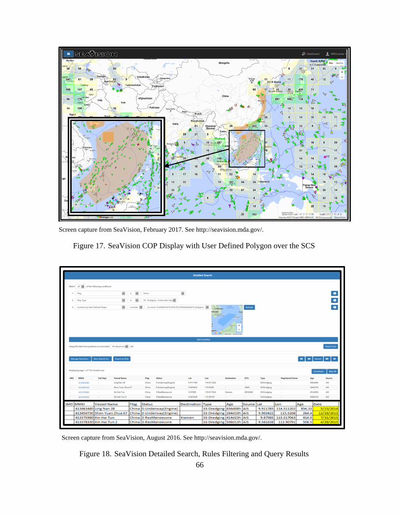
66
Screen capture from SeaVision, February 2017. See http://seavision.mda.gov/.
SeaVision COP Display with User Defined Polygon over the SCS Figure 17.
Screen capture from SeaVision, August 2016. See http://seavision.mda.gov/.
SeaVision Detailed Search, Rules Filtering and Query Results Figure 18.
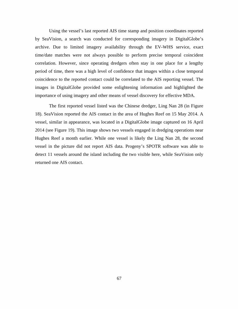
67
Using the vessel’s last reported AIS time stamp and position coordinates reported
by SeaVision, a search was conducted for corresponding imagery in DigitalGlobe’s
archive. Due to limited imagery availability through the EV-WHS service, exact
time/date matches were not always possible to perform precise temporal coincident
correlation. However, since operating dredgers often stay in one place for a lengthy
period of time, there was a high level of confidence that images within a close temporal
coincidence to the reported contact could be correlated to the AIS reporting vessel. The
images in DigitalGlobe provided some enlightening information and highlighted the
importance of using imagery and other means of vessel discovery for effective MDA.
The first reported vessel listed was the Chinese dredger, Ling Nan 28 (in Figure
18). SeaVision reported the AIS contact in the area of Hughes Reef on 15 May 2014. A
vessel, similar in appearance, was located in a DigitalGlobe image captured on 16 April
2014 (see Figure 19). This image shows two vessels engaged in dredging operations near
Hughes Reef a month earlier. While one vessel is likely the Ling Nan 28, the second
vessel in the picture did not report AIS data. Progeny’s SPOTR software was able to
detect 11 vessels around the island including the two visible here, while SeaVision only
returned one AIS contact.
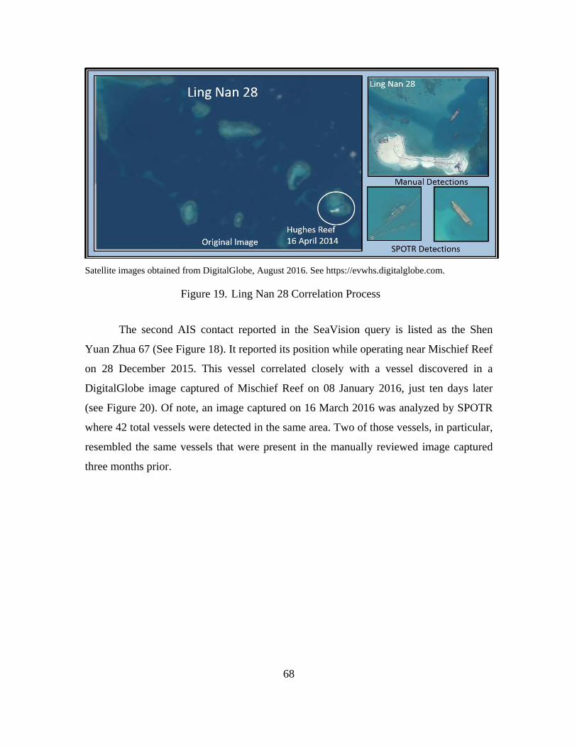
68
Satellite images obtained from DigitalGlobe, August 2016. See https://evwhs.digitalglobe.com.
Ling Nan 28 Correlation Process Figure 19.
The second AIS contact reported in the SeaVision query is listed as the Shen
Yuan Zhua 67 (See Figure 18). It reported its position while operating near Mischief Reef
on 28 December 2015. This vessel correlated closely with a vessel discovered in a
DigitalGlobe image captured of Mischief Reef on 08 January 2016, just ten days later
(see Figure 20). Of note, an image captured on 16 March 2016 was analyzed by SPOTR
where 42 total vessels were detected in the same area. Two of those vessels, in particular,
resembled the same vessels that were present in the manually reviewed image captured
three months prior.
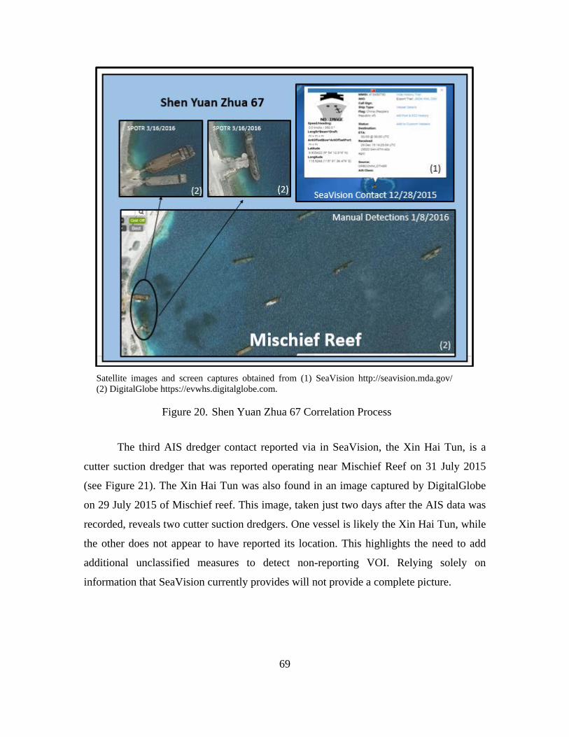
69
Satellite images and screen captures obtained from (1) SeaVision http://seavision.mda.gov/ (2) DigitalGlobe https://evwhs.digitalglobe.com.
Shen Yuan Zhua 67 Correlation Process Figure 20.
The third AIS dredger contact reported via in SeaVision, the Xin Hai Tun, is a
cutter suction dredger that was reported operating near Mischief Reef on 31 July 2015
(see Figure 21). The Xin Hai Tun was also found in an image captured by DigitalGlobe
on 29 July 2015 of Mischief reef. This image, taken just two days after the AIS data was
recorded, reveals two cutter suction dredgers. One vessel is likely the Xin Hai Tun, while
the other does not appear to have reported its location. This highlights the need to add
additional unclassified measures to detect non-reporting VOI. Relying solely on
information that SeaVision currently provides will not provide a complete picture.
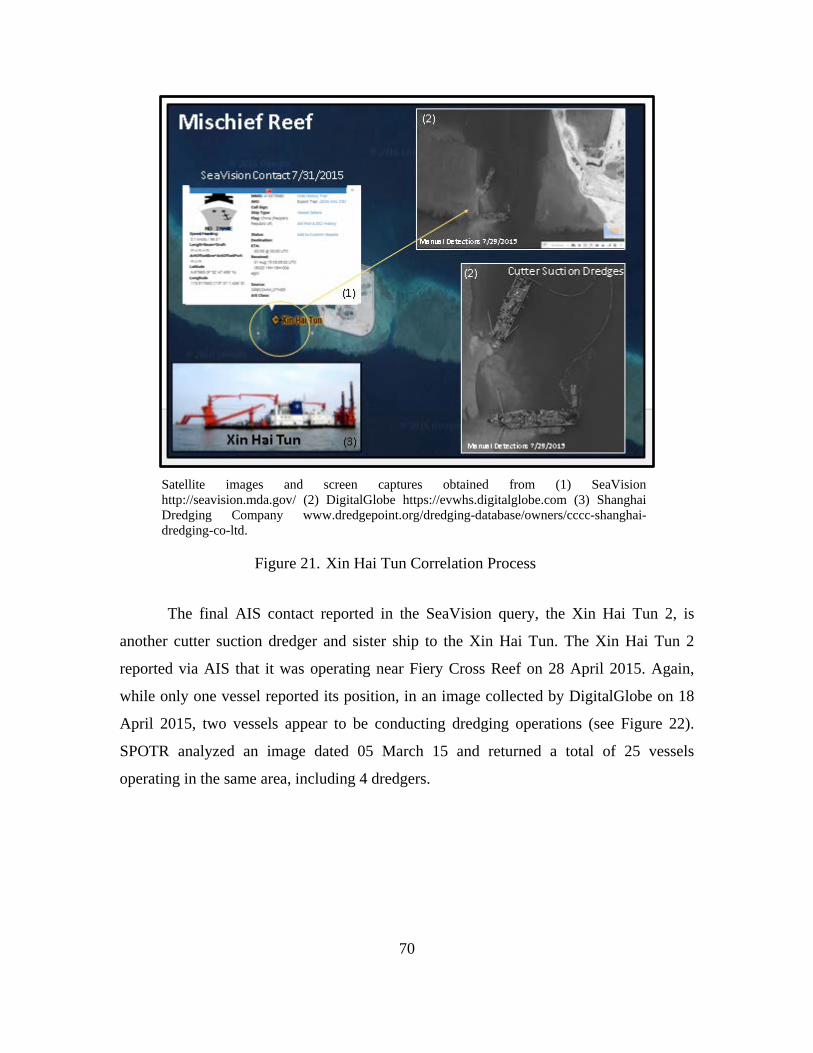
70
Satellite images and screen captures obtained from (1) SeaVision http://seavision.mda.gov/ (2) DigitalGlobe https://evwhs.digitalglobe.com (3) Shanghai Dredging Company www.dredgepoint.org/dredging-database/owners/cccc-shanghai-dredging-co-ltd.
Xin Hai Tun Correlation Process Figure 21.
The final AIS contact reported in the SeaVision query, the Xin Hai Tun 2, is
another cutter suction dredger and sister ship to the Xin Hai Tun. The Xin Hai Tun 2
reported via AIS that it was operating near Fiery Cross Reef on 28 April 2015. Again,
while only one vessel reported its position, in an image collected by DigitalGlobe on 18
April 2015, two vessels appear to be conducting dredging operations (see Figure 22).
SPOTR analyzed an image dated 05 March 15 and returned a total of 25 vessels
operating in the same area, including 4 dredgers.
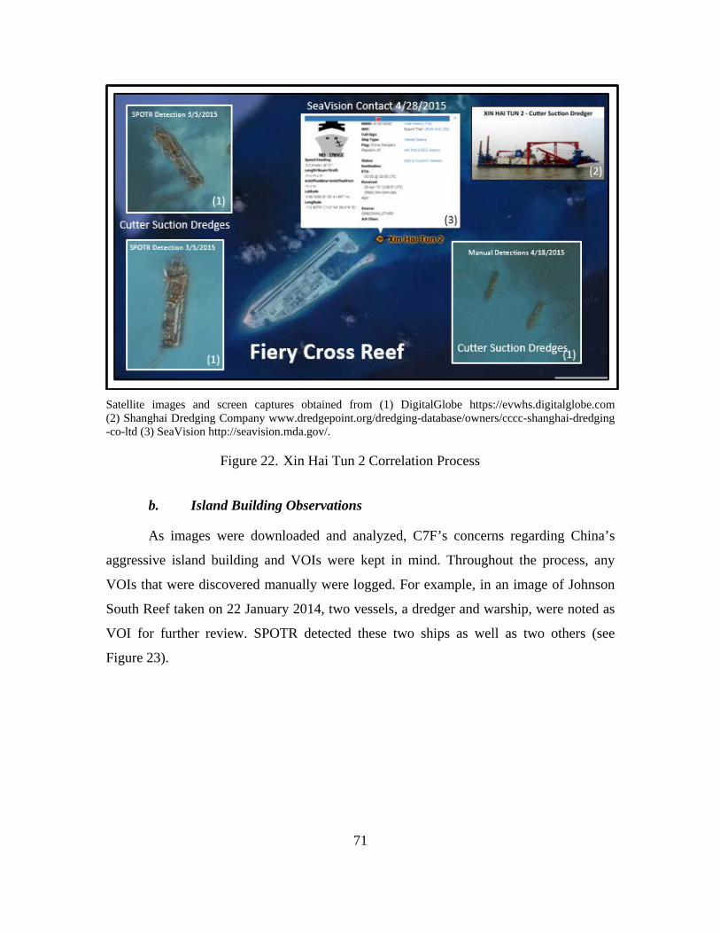
71
Satellite images and screen captures obtained from (1) DigitalGlobe https://evwhs.digitalglobe.com (2) Shanghai Dredging Company www.dredgepoint.org/dredging-database/owners/cccc-shanghai-dredging -co-ltd (3) SeaVision http://seavision.mda.gov/.
Xin Hai Tun 2 Correlation Process Figure 22.
b. Island Building Observations
As images were downloaded and analyzed, C7F’s concerns regarding China’s
aggressive island building and VOIs were kept in mind. Throughout the process, any
VOIs that were discovered manually were logged. For example, in an image of Johnson
South Reef taken on 22 January 2014, two vessels, a dredger and warship, were noted as
VOI for further review. SPOTR detected these two ships as well as two others (see
Figure 23).
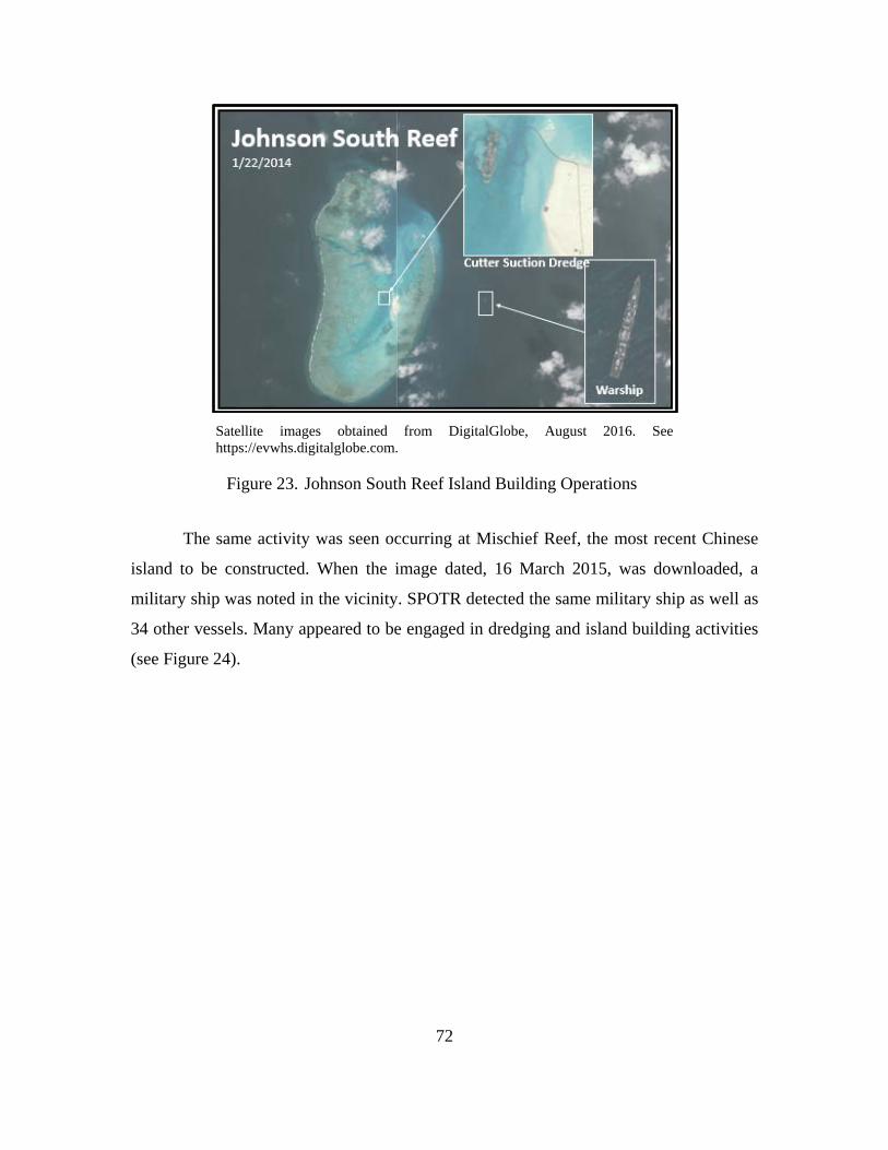
72
Satellite images obtained from DigitalGlobe, August 2016. See https://evwhs.digitalglobe.com.
Johnson South Reef Island Building Operations Figure 23.
The same activity was seen occurring at Mischief Reef, the most recent Chinese
island to be constructed. When the image dated, 16 March 2015, was downloaded, a
military ship was noted in the vicinity. SPOTR detected the same military ship as well as
34 other vessels. Many appeared to be engaged in dredging and island building activities
(see Figure 24).
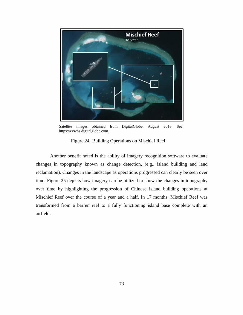
73
Satellite images obtained from DigitalGlobe, August 2016. See https://evwhs.digitalglobe.com.
Building Operations on Mischief Reef Figure 24.
Another benefit noted is the ability of imagery recognition software to evaluate
changes in topography known as change detection, (e.g., island building and land
reclamation). Changes in the landscape as operations progressed can clearly be seen over
time. Figure 25 depicts how imagery can be utilized to show the changes in topography
over time by highlighting the progression of Chinese island building operations at
Mischief Reef over the course of a year and a half. In 17 months, Mischief Reef was
transformed from a barren reef to a fully functioning island base complete with an
airfield.
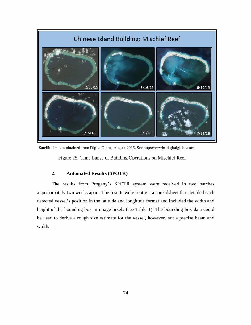
74
Satellite images obtained from DigitalGlobe, August 2016. See https://evwhs.digitalglobe.com.
Time Lapse of Building Operations on Mischief Reef Figure 25.
2. Automated Results (SPOTR)
The results from Progeny’s SPOTR system were received in two batches
approximately two weeks apart. The results were sent via a spreadsheet that detailed each
detected vessel’s position in the latitude and longitude format and included the width and
height of the bounding box in image pixels (see Table 1). The bounding box data could
be used to derive a rough size estimate for the vessel, however, not a precise beam and
width.
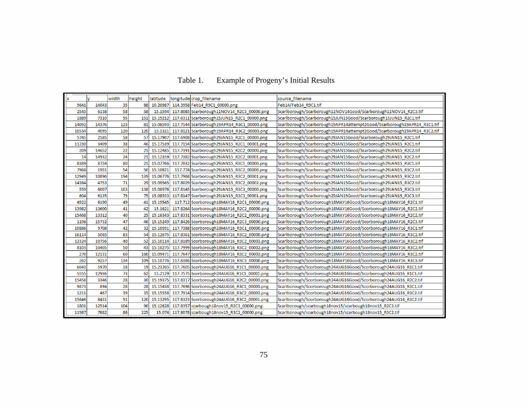
75
Example of Progeny’s Initial Results Table 1.
76
Along with the spreadsheet of information, Progeny returned actual images of
each vessel detected. Overall, Progeny’s results indicated that 11,870 vessels were
detected in the 1,361 image tiles analyzed. See Appendix A for a specific breakdown of
the results. The results were studied for accuracy and further analysis and interpretation.
The advantages and limitations determined from the initial round of SPOTR imagery
analysis are discussed in the following sections.
a. SPOTR Advantages
The SPOTR results yielded some impressive detection capabilities that have great
potential for use in the proposed CONOPS. Numerous instances showed how SPOTR
could be leveraged to automate the information collection and processing steps of the
TCPED model. SPOTR’s computer vision can be a force multiplier by providing an
additional capacity to gather data beyond the capabilities of an intel analyst by detecting
vessels that would be nearly impossible to see by the human eye alone. The following
subsections describe these positive attributes in detail.
(1) Automated Detection
Although the process to get the imagery to Progeny was manually intensive, the
results were significant. The images sent for analysis covered large sections of ocean;
some over 400 square miles. Searching these images for a VOI, whose exact position is
not known, would be near impossible for an intelligence analyst. It is unlikely that the
human eye would be able to find all the results that SPOTR was capable of and certainly
not as quickly. Furthermore, SPOTR was regularly able to break out vessels in situations
where distractions and clutter would also make it difficult for the human eye. For
example, the image of Scarborough Shoal captured on 15 June 2015 covers 230 square
miles and contains 16% cloud cover. At first glance, it does not appear there are any
vessels in the image. However, SPOTR did detect a single vessel as shown (see
Figure 26).
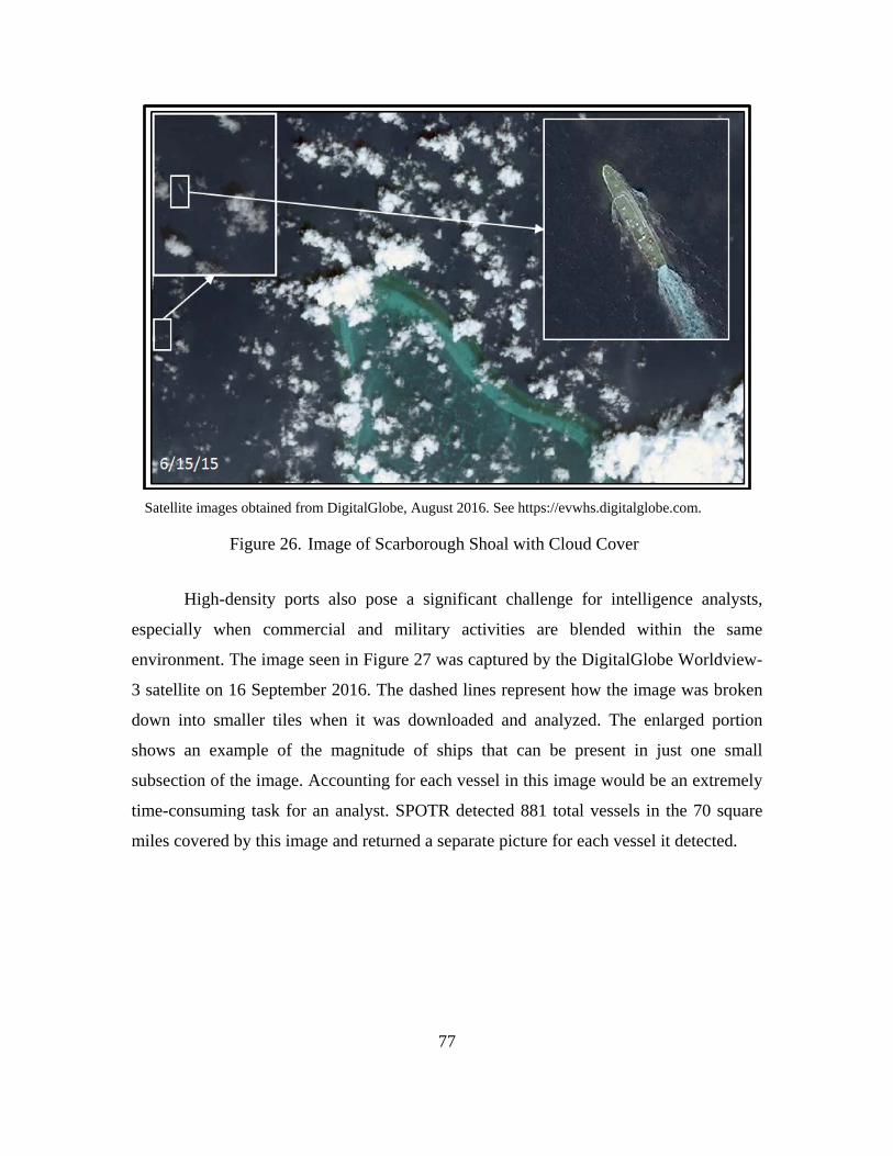
77
Satellite images obtained from DigitalGlobe, August 2016. See https://evwhs.digitalglobe.com.
Image of Scarborough Shoal with Cloud Cover Figure 26.
High-density ports also pose a significant challenge for intelligence analysts,
especially when commercial and military activities are blended within the same
environment. The image seen in Figure 27 was captured by the DigitalGlobe Worldview-
3 satellite on 16 September 2016. The dashed lines represent how the image was broken
down into smaller tiles when it was downloaded and analyzed. The enlarged portion
shows an example of the magnitude of ships that can be present in just one small
subsection of the image. Accounting for each vessel in this image would be an extremely
time-consuming task for an analyst. SPOTR detected 881 total vessels in the 70 square
miles covered by this image and returned a separate picture for each vessel it detected.
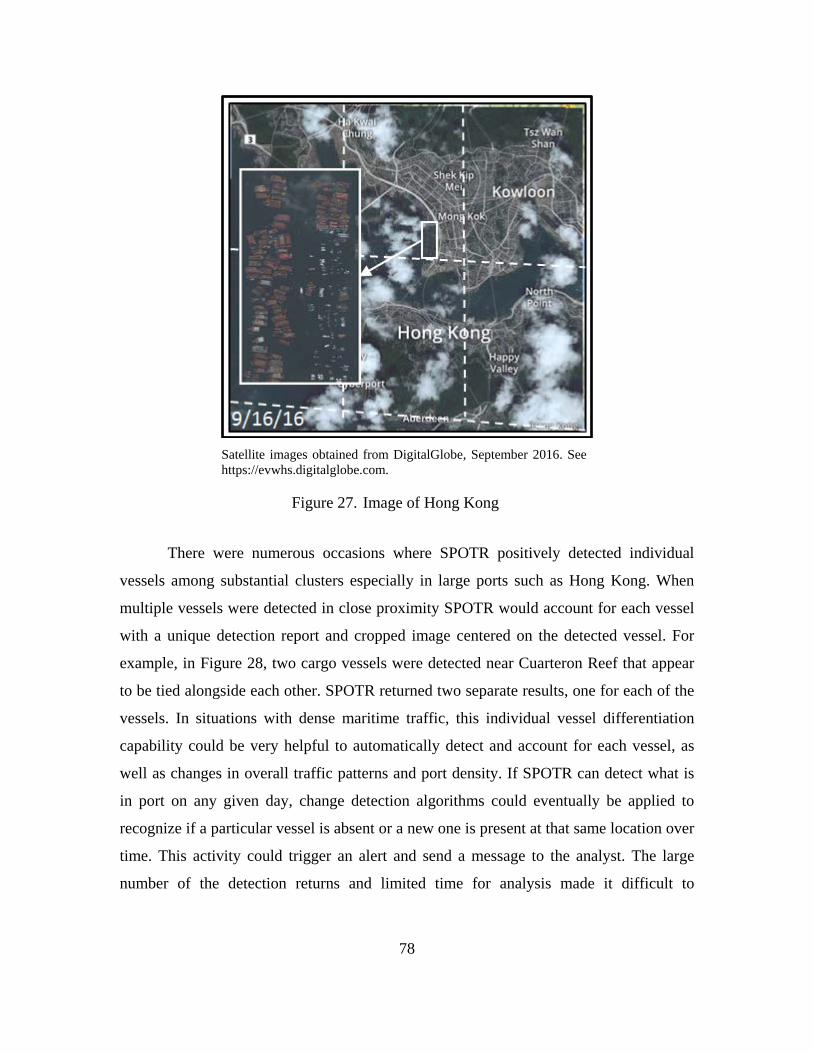
78
Satellite images obtained from DigitalGlobe, September 2016. See https://evwhs.digitalglobe.com.
Image of Hong Kong Figure 27.
There were numerous occasions where SPOTR positively detected individual
vessels among substantial clusters especially in large ports such as Hong Kong. When
multiple vessels were detected in close proximity SPOTR would account for each vessel
with a unique detection report and cropped image centered on the detected vessel. For
example, in Figure 28, two cargo vessels were detected near Cuarteron Reef that appear
to be tied alongside each other. SPOTR returned two separate results, one for each of the
vessels. In situations with dense maritime traffic, this individual vessel differentiation
capability could be very helpful to automatically detect and account for each vessel, as
well as changes in overall traffic patterns and port density. If SPOTR can detect what is
in port on any given day, change detection algorithms could eventually be applied to
recognize if a particular vessel is absent or a new one is present at that same location over
time. This activity could trigger an alert and send a message to the analyst. The large
number of the detection returns and limited time for analysis made it difficult to
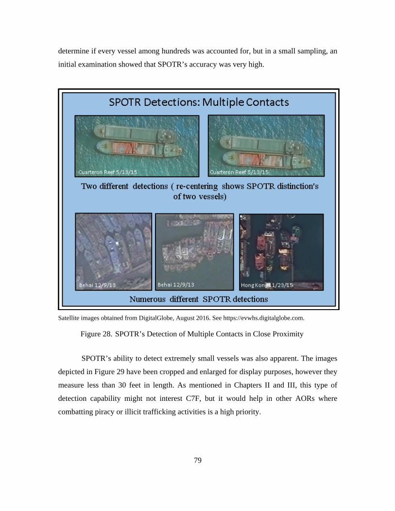
79
determine if every vessel among hundreds was accounted for, but in a small sampling, an
initial examination showed that SPOTR’s accuracy was very high.
Satellite images obtained from DigitalGlobe, August 2016. See https://evwhs.digitalglobe.com.
SPOTR’s Detection of Multiple Contacts in Close Proximity Figure 28.
SPOTR’s ability to detect extremely small vessels was also apparent. The images
depicted in Figure 29 have been cropped and enlarged for display purposes, however they
measure less than 30 feet in length. As mentioned in Chapters II and III, this type of
detection capability might not interest C7F, but it would help in other AORs where
combatting piracy or illicit trafficking activities is a high priority.
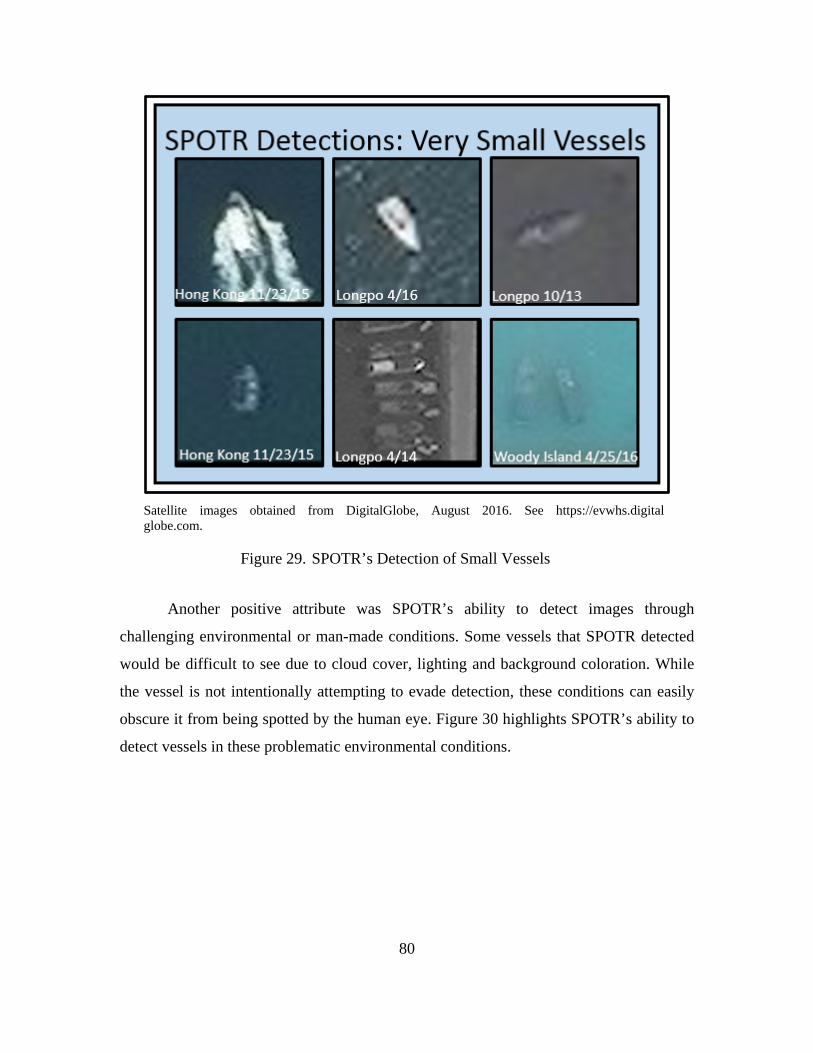
80
Satellite images obtained from DigitalGlobe, August 2016. See https://evwhs.digital globe.com.
SPOTR’s Detection of Small Vessels Figure 29.
Another positive attribute was SPOTR’s ability to detect images through
challenging environmental or man-made conditions. Some vessels that SPOTR detected
would be difficult to see due to cloud cover, lighting and background coloration. While
the vessel is not intentionally attempting to evade detection, these conditions can easily
obscure it from being spotted by the human eye. Figure 30 highlights SPOTR’s ability to
detect vessels in these problematic environmental conditions.
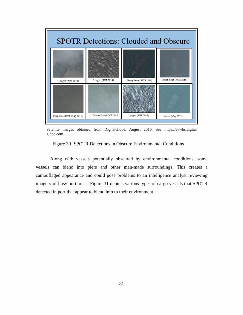
81
Satellite images obtained from DigitalGlobe, August 2016. See https://evwhs.digital globe.com.
SPOTR Detections in Obscure Environmental Conditions Figure 30.
Along with vessels potentially obscured by environmental conditions, some
vessels can blend into piers and other man-made surroundings. This creates a
camouflaged appearance and could pose problems to an intelligence analyst reviewing
imagery of busy port areas. Figure 31 depicts various types of cargo vessels that SPOTR
detected in port that appear to blend into to their environment.
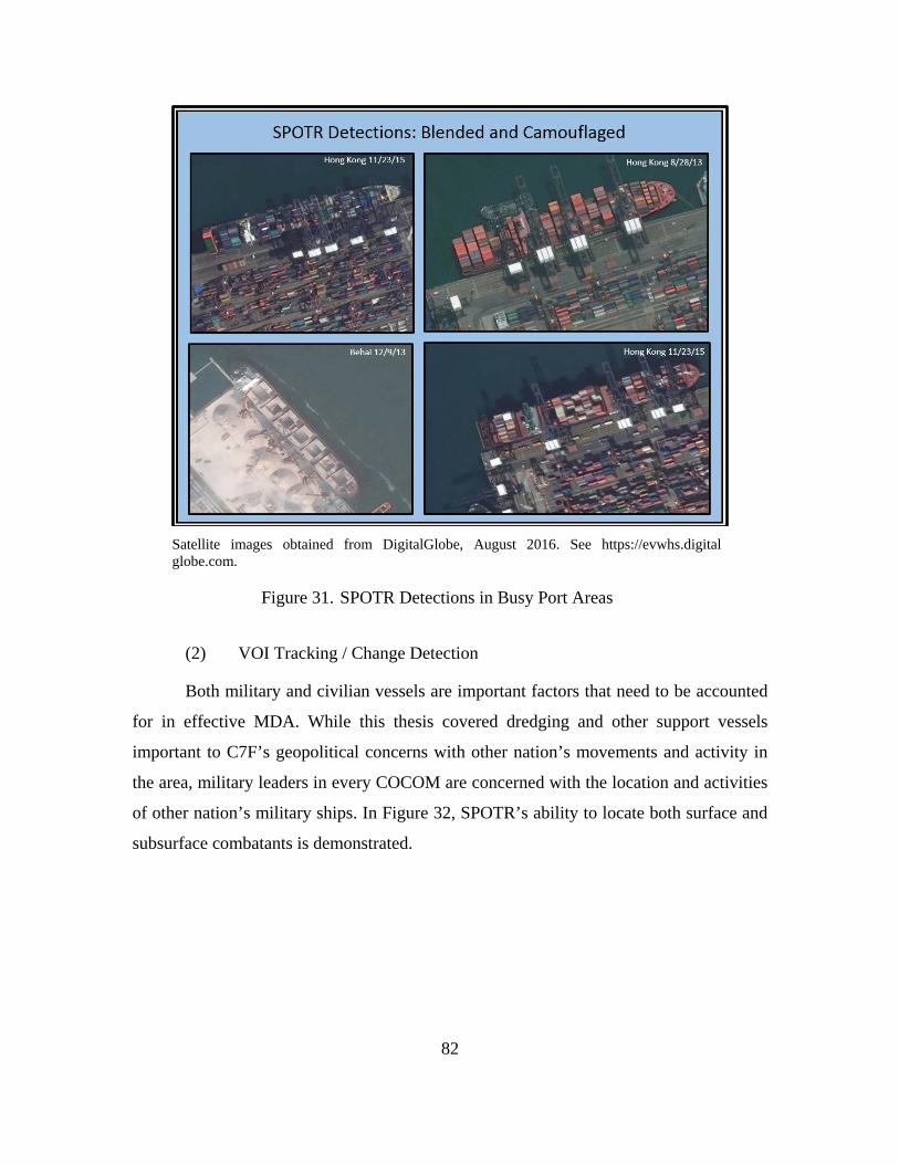
82
Satellite images obtained from DigitalGlobe, August 2016. See https://evwhs.digital globe.com.
SPOTR Detections in Busy Port Areas Figure 31.
(2) VOI Tracking / Change Detection
Both military and civilian vessels are important factors that need to be accounted
for in effective MDA. While this thesis covered dredging and other support vessels
important to C7F’s geopolitical concerns with other nation’s movements and activity in
the area, military leaders in every COCOM are concerned with the location and activities
of other nation’s military ships. In Figure 32, SPOTR’s ability to locate both surface and
subsurface combatants is demonstrated.
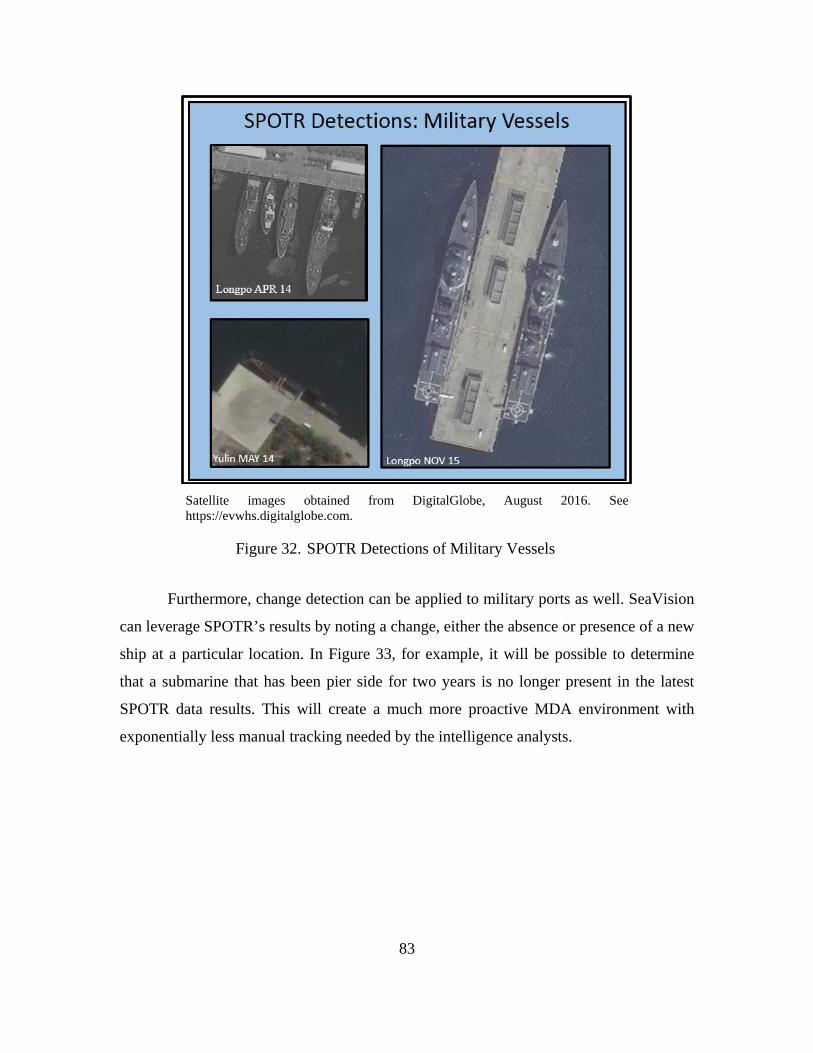
83
Satellite images obtained from DigitalGlobe, August 2016. See https://evwhs.digitalglobe.com.
SPOTR Detections of Military Vessels Figure 32.
Furthermore, change detection can be applied to military ports as well. SeaVision
can leverage SPOTR’s results by noting a change, either the absence or presence of a new
ship at a particular location. In Figure 33, for example, it will be possible to determine
that a submarine that has been pier side for two years is no longer present in the latest
SPOTR data results. This will create a much more proactive MDA environment with
exponentially less manual tracking needed by the intelligence analysts.
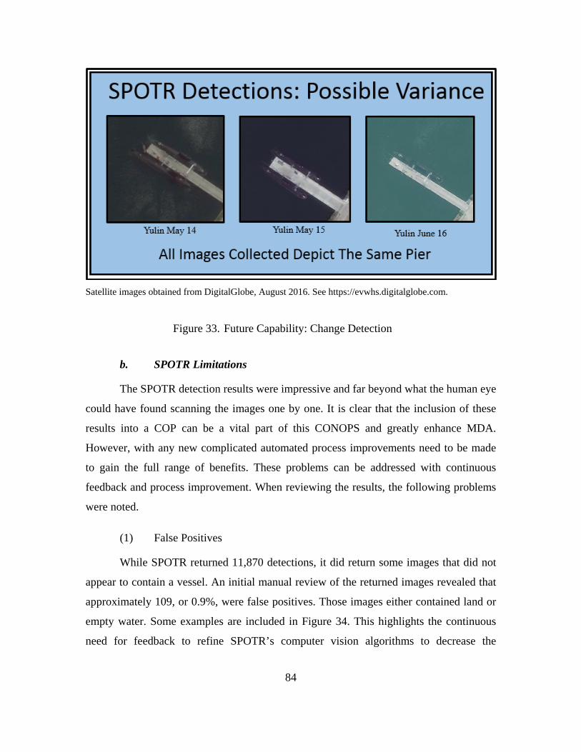
84
Satellite images obtained from DigitalGlobe, August 2016. See https://evwhs.digitalglobe.com.
Future Capability: Change Detection Figure 33.
b. SPOTR Limitations
The SPOTR detection results were impressive and far beyond what the human eye
could have found scanning the images one by one. It is clear that the inclusion of these
results into a COP can be a vital part of this CONOPS and greatly enhance MDA.
However, with any new complicated automated process improvements need to be made
to gain the full range of benefits. These problems can be addressed with continuous
feedback and process improvement. When reviewing the results, the following problems
were noted.
(1) False Positives
While SPOTR returned 11,870 detections, it did return some images that did not
appear to contain a vessel. An initial manual review of the returned images revealed that
approximately 109, or 0.9%, were false positives. Those images either contained land or
empty water. Some examples are included in Figure 34. This highlights the continuous
need for feedback to refine SPOTR’s computer vision algorithms to decrease the
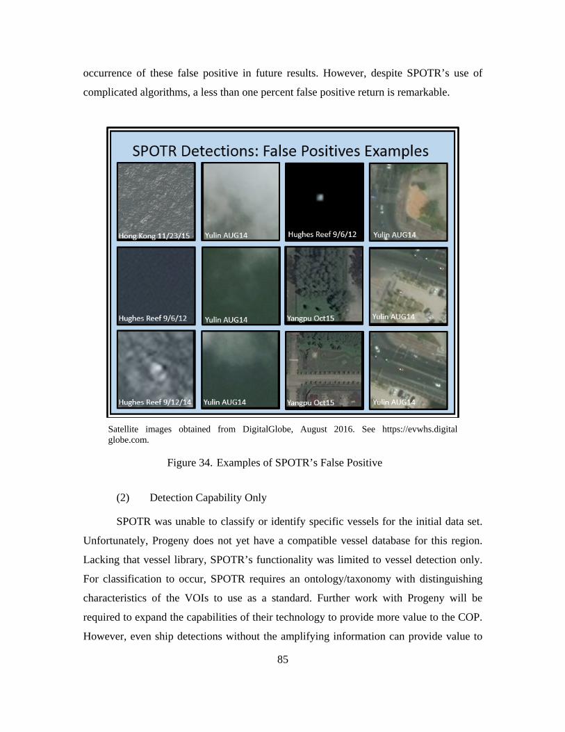
85
occurrence of these false positive in future results. However, despite SPOTR’s use of
complicated algorithms, a less than one percent false positive return is remarkable.
Satellite images obtained from DigitalGlobe, August 2016. See https://evwhs.digital globe.com.
Examples of SPOTR’s False Positive Figure 34.
(2) Detection Capability Only
SPOTR was unable to classify or identify specific vessels for the initial data set.
Unfortunately, Progeny does not yet have a compatible vessel database for this region.
Lacking that vessel library, SPOTR’s functionality was limited to vessel detection only.
For classification to occur, SPOTR requires an ontology/taxonomy with distinguishing
characteristics of the VOIs to use as a standard. Further work with Progeny will be
required to expand the capabilities of their technology to provide more value to the COP.
However, even ship detections without the amplifying information can provide value to
86
the COP. It can still be utilized to alert the analyst that something is present that may
warrant their interest. The detected unknown vessel could also be overlaid with a known
contact from another source with which it can be fused, adding confidence to the track.
C. CHAPTER SUMMARY
Overall, SPOTR’s results show significant promise. There are indications that
intrinsic value could be derived by an intelligence analyst using a system with these types
of results included. As described previously, SPOTR is trained to locate, classify and
identify vessels based on finely tuned algorithms. Once the results are input into
SeaVision, it can alert the human analyst to investigate a contact more in depth. The COP
only provides information such as the who, what, where and when as related to vessel
movements. The IC still needs to determine the why, how and/or various implications of
the picture. For example, SPOTR detected two vessels near Scarborough Shoal (see
Figure 35). In time, it may also be able to determine that they are a Chinese Coast Guard
Cutter and a Filipino fishing boat, for example. This data is input into SeaVision and an
analyst is alerted. The analyst downloads the image and confirms the vessel classification
is correct. The analyst will also note that the cutter is in a high-speed turn and
maneuvering closer to the smaller fishing vessel. While this is just a fabricated example
to show the system’s promise, this is a type of situation that mirrors reality. There are
numerous incidents that have been reported indicating that Chinese Coast Guard vessels
have harassed Filipino fishermen around Scarborough Shoal (Maresca, 2015).
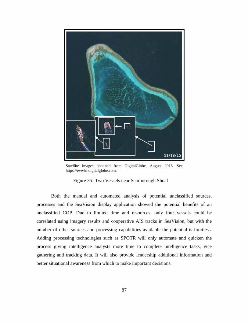
87
Satellite images obtained from DigitalGlobe, August 2016. See https://evwhs.digitalglobe.com.
Two Vessels near Scarborough Shoal Figure 35.
Both the manual and automated analysis of potential unclassified sources,
processes and the SeaVision display application showed the potential benefits of an
unclassified COP. Due to limited time and resources, only four vessels could be
correlated using imagery results and cooperative AIS tracks in SeaVision, but with the
number of other sources and processing capabilities available the potential is limitless.
Adding processing technologies such as SPOTR will only automate and quicken the
process giving intelligence analysts more time to complete intelligence tasks, vice
gathering and tracking data. It will also provide leadership additional information and
better situational awareness from which to make important decisions.

88
THIS PAGE INTENTIONALLY LEFT BLANK
89
V. CONCLUSIONS AND RECOMMENDATIONS
A. SUMMARY OF RESULTS
The goal of this thesis was to construct an unclassified CONOPS strategy to meet
the evolving needs of fleet and operational commanders in the execution of MDA. The
CONOPS presented is the result of extensive research into current operational MDA
methods and requirements and new or improved ISR technologies. Those findings were
used to develop a CONOPS that could produce unclassified data fused from numerous
input sources that is low-cost, low bandwidth and easy to use. Having developed a
CONOPS that met those requirements in theory, it was tested to validate its feasibility
and flush out the initial imperfections.
The testing methods simulated the recommended process by utilizing the same
technologies for data retrieval, processing and display suggested in the CONOPS,
DigitalGlobe, SPOTR and SeaVision respectively. The concept behind the initial attempt
was to detect, classify and identify a set of non-cooperative vessels using only the
unclassified technologies suggested. Due to time and access constraints, however, a
complete test of the CONOPS was not possible. The classification, identification and data
input steps of testing via the automated system was not completed. The manual method
and automated detection results received did expose multiple strengths and weakness of
the three subsystems used and the overall CONOPS processes that can be improved upon
in future attempts to test and refine the process.
B. PROCESS IMPROVEMENTS
This CONOPS is still at a theoretical stage, but based on the research and initial
testing, it could have far-reaching positive effects within the MDA enterprise.
Unfortunately, most new processes and systems that are initiated often whither on the
vine without proper support. The next steps following this research will be very important
in moving towards process implementation. This research produced a thorough and
workable CONOPS theory, but it must be further developed and continually refined.
Some of the challenges and limitations that were encountered throughout the testing
90
process were later resolved and should be applied to future attempts in proving the
concept.
The single biggest improvement to this process would be to gain access to large
batches of imagery for the AOI through assistance with the NGA and DigitalGlobe. If
this is still not an option, there are a couple simple changes that will improve the
download process. As mentioned in Chapter IV, the process to download and send
images to Progeny was fairly lengthy. After the initial test run was complete,
DigitalGlobe introduced a new way to download images via an AWS S3 bucket. AWS is
Amazon’s portfolio of cloud computing services and the S3 bucket is the cloud-based
web storage service. This added service introduces a new and faster way to complete the
transfer process. It allows for a direct bucket to bucket cloud-based storage and transfer
which will exponentially decrease the time required to move images from DigitalGlobe’s
database to Progeny’s from hours to seconds. Future download batches should utilize this
method to alleviate the delays and glitches caused by download speeds, image
consolidations, hard drive transfers and shipments.
Another important update to the process involves the file download format. As
mentioned in Chapter IV, the initial batch of imagery delivered to Progeny was not in the
best possible format. The initial format chosen, GeoTiff, does not preserve all of the
original image metadata. In particular, the date and time of image capture and download
were not included. This data is necessary to eventually derive specific information to aid
in image detections and track information. While the GeoTiff formats were acceptable for
the initial test run, the missing data will be critical for future iterations where track data
can be input into SeaVision. Progeny recommended that the National Imagery
Transmission Format Standard (NITFS) be used for future downloads to preserve all
necessary data to create the appropriate message format for eventual data transfer to the
SeaVision COP application.
As discussed, the initial SPOTR test was only successful in detecting vessels in
the imagery. To improve SPOTR’s classification and identification processes, it will be
necessary to expand the image and model library that Progeny uses for classification and
identification. SPOTR is an extremely powerful tool that is capable of making VOI
91
identifications only if it is provided the appropriate seed gallery for image comparison.
Building the initial seed gallery can be done a couple of ways. Human in the loop or
crowdsourced data mining via AIS reports and other electronic tracking data feedback
can assist the special and temporal machine learning process. For instance, future
research can use SeaVision to collect a 90-day history of AIS data in a specific AOI and
then collect a 90-day history of imagery of the same locations. SPOTR will detect vessels
and provide information on date, time and location. Then correlations to identify the
vessels can be performed as was done in the initial manual testing of this CONOPS.
SeaVision’s limited archive of AIS data precluded this step from being taken on the
initial tranche of imagery analyzed by SPOTR. Once this seed gallery is created and
refined, the full power of SPOTR will be realized. Unfortunately, as noted in this
research, most vessels that SPOTR will detect are not all reporting their position and
vessel information. The better, and perhaps faster solution, would be to gain access to or
purchase images and 3D models of known ship types and VOI information from ONI or
other collection agencies for direct input into the system. Once the SPOTR detections can
be input into SeaVision, then steps can be taken to further automate the feedback process
described above. Any SeaVision or manual AIS/SPOTR detection correlations could be
sent back via a feedback loop to SPOTR for system refinement.
C. RECOMMENDATIONS FOR FUTURE RESEARCH
The research and preliminary tests of the proposed unclassified CONOPS
demonstrated that the unclassified technology behind the concept is sound, but in order
for the unclassified comprehensive COP to be a reality much more work must be done.
More effort needs to be made to integrate the various technologies together to form the
complete COP. The next steps should include importing the imagery-based SPOTR
derived track data into SeaVision and maturing the SeaVision application as future
capabilities become available.
1. Import Imagery Data into SeaVision
The most significant hurdle to making the COP a reality is transforming SPOTR
derived track data into an acceptable message format for input into SeaVision real time.
92
Certain steps are required to import the current SPOTR contact and tracking information
to the SeaVision COP. Along with using the correct image download format, NITFS, the
speed of data acquisition and transfer must be increased. Initially, time can be saved by
transferring the images to SPOTR via the AWS S3 bucket mentioned previously, but real
world implementation of this CONOPS requires a direct imagery data downlink feed to
SPOTR from the collection sources to reduce delay. This will provide the most up to date
information as possible to the COP. However, the analyst is at the mercy of the daily
scheduled imagery take from the satellite which may not meet their specific needs real
time. In that case, when specific or more instantaneous imagery needs are required, the
system can be supplemented with the CTAR process described in Chapter III. CTAR has
the potential to allow analysts direct access to a commercial satellite. They can decide
specifically what imagery is taken and when. The data will then be sent directly to their
remote moveable ground station for immediate processing. This method is expensive, so
will likely be used sparingly. It also requires further testing to determine its practicality as
a means of data acquisition. This could potentially close the time gap from collection to
display when the normal process may be too slow.
The next challenge to overcome is displaying the SPOTR data on the SeaVision
COP. This will require the data to be input into the proper message format. One of the
primary reasons SeaVision was selected for the COP display is because it is already built
to allow NIEM conformant exchanges (Department of Transportation, n.d.). This means
that SeaVision can quickly assimilate new data sources, including those from new
services, other agencies and foreign partners. The Volpe Center built, deployed and
continues to leverage the low-cost, unclassified, near-real time Maritime Safety and
Security Information System (MSSIS) network which enables collaboration and data-
sharing between government agencies and foreign partners (Volpe Center, n.d.). The new
data source, SPOTR in this case, will need to transfer the data in a format compatible
with the MSSIS network. Progeny supplied the initial results via datasets in both Comma
Separated Value and JavaScript Object Notation formats. In the future, the data needs to
be refined and put into the specific format for SeaVision to use. SeaVision uses the
PVOL format to integrate satellite imagery detection data into MSSIS. This format
93
applies four-corner point latitude and longitude coordinates, as well as contact course,
speed, estimated size and sensor information (J. Stastny, personal communication,
October 24, 2016). As SPOTR will likely provide additional details about the imagery
detections that are not already common in the PVOL format, specifically classification
and identification, new fields may be required so SeaVision can perform correlation and
fusion with the more granular details provided by other sources. Due to the lack of time
to fully develop target sets, this step could not be completed. Progeny and the Volpe
Center will need to work together to build the proper protocols in order to establish data
security, authenticity and availability as information passes from one to the other. Once
this protocol is established a direct channel between SPOTR and SeaVision will allow the
track data to be ingested directly into the COP.
2. Transition to Future Capabilities
This CONOPS is meant to allow for future growth and expansion providing
capabilities beyond data display and correlation if desired. With the proper tools in place,
it could be leveraged for social network analysis along with big data analytics and
dynamic logic to go beyond the who, what, where and when, but start to answer the why
and how. Most COPs in existence today fail to provide information beyond answering the
questions of who and where (Arciszewski & De Greef, 2011). Recent advances in big
data analytics could provide new ways to further exploit the information this COP
provides. With high-level data abstractions and advanced fusion techniques, detection of
VOI operating patterns may be detected. With a big data approach, the sources of the
unclassified COP could be ingested into a distributed file system to derive big data
solutions that recognize such patterns. Analysis of these patterns and social networks can
provide suggestions on how monitored vessels match planned or predicted movements or
actions. These patterns of life could aid in the determination of activity and intent which
would be a breakthrough in data exploitation.
In the case of MDA, information including unit capabilities, status information,
known movements between ports and various interactions can be projected as a data set
to provide the commander information. The data sets could include unclassified
94
information on vessels, such as port or registry, crew, builder and/or owner that is
reported and verifiable, which can be used to build a multimodal network of
commonalities to analyze. This information and analysis system will likely create an
intelligence solution that will no longer fall into the unclassified domain, and is therefore,
not a focus of this thesis, but is an interesting possible extension of the CONOPS
presented.
D. CONCLUSION
New and evolving maritime threats and concerns require new and creative ways
to conduct MDA. The CONOPS presented in this thesis is a simple yet powerful tool that
creates a collaborative platform for all concerned entities to share information. It
combines cooperative vessel tracking systems already in place with processed data
derived from high-resolution commercial satellite imagery to provide data on vessel
movements all over the world. Initial testing demonstrated that together these systems
can provide a wealth of information in a fraction of the time and cost required by the
cumbersome methods used currently. Further development will be required to move the
CONOPS from theory to reality, but the capabilities to make the transition exist.
Additionally, beyond the new and expanding COTS technologies suggested, the
CONOPS provides an avenue for future growth because of its inherent flexibility,
scalability and extensibility. Changes in the input sources to SeaVision, a service-
orientated application, rarely affect the user. As long as the changes present the user with
added benefits and remain easy to use, adoptability and acceptability will not be a
concern.
As with any new information platform utilized by the operators and analysts,
especially one which provides valuable information on the movements of national and
foreign assets, there will be some pushback. This will arise from concerns as to the level
of information the system provides and who has access to it. This CONOPS provides a
means to gather and share public information via a platform that is unclassified from
source to display. As long as the information presented in this platform remains of
common interest to all users, such as securing borders and the freedom of movement,

95
classification concerns should be minimal. It simply provides a single comprehensive
capability that could allow the flow of useful unclassified information between agencies
and allies to enable an effective MDA environment beneficial to all.

96
THIS PAGE INTENTIONALLY LEFT BLANK
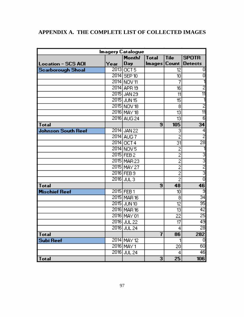
97
APPENDIX A. THE COMPLETE LIST OF COLLECTED IMAGES
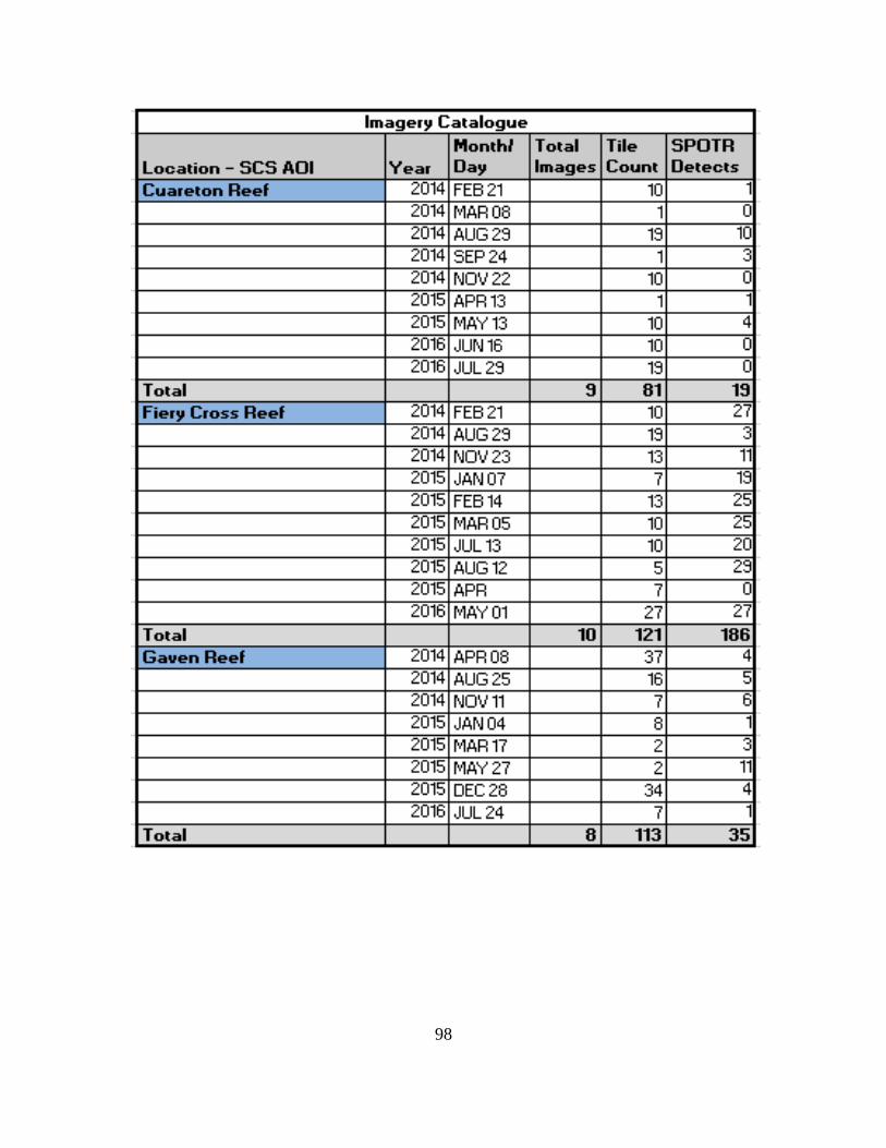
98
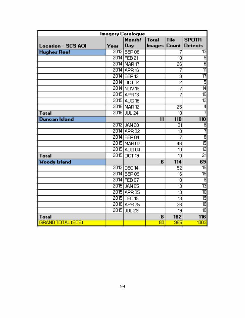
99
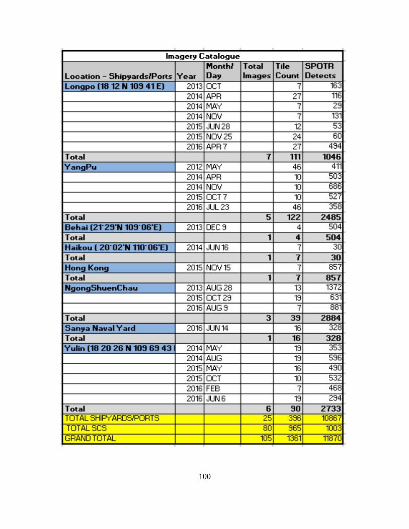
100
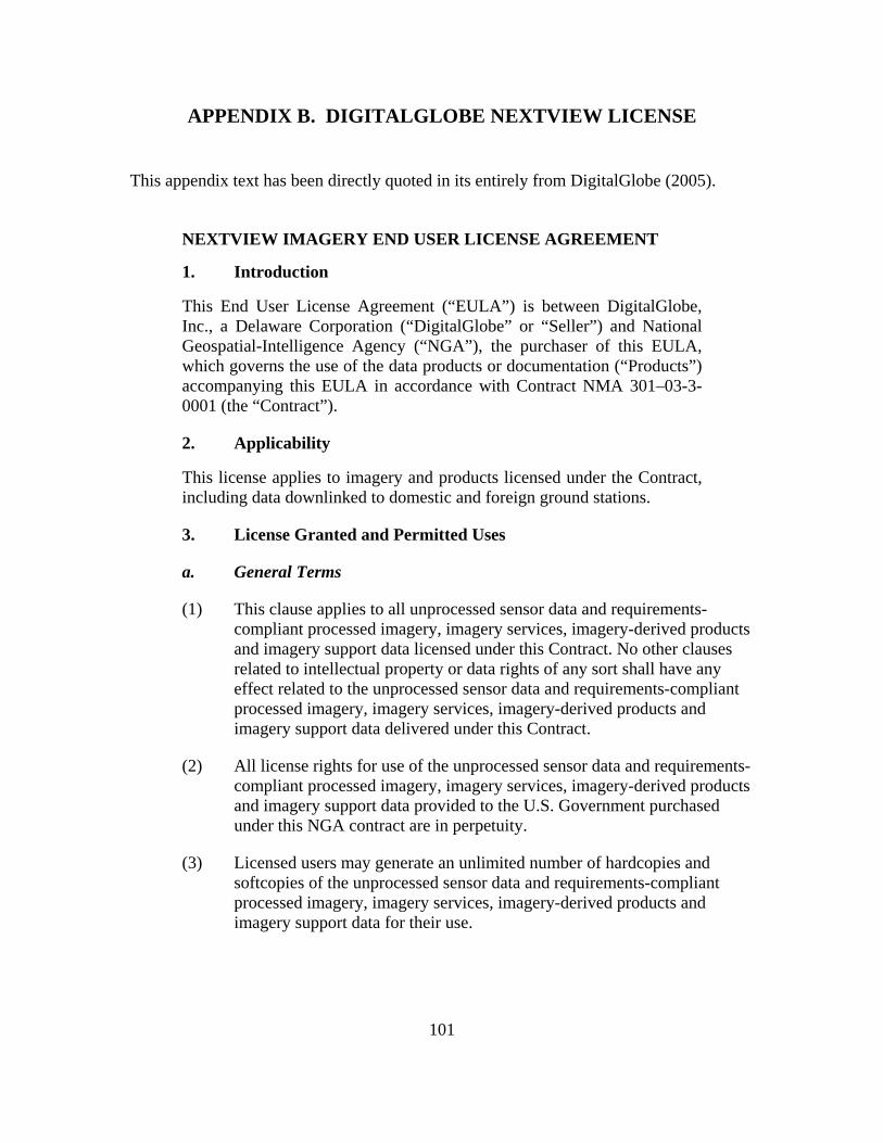
101
APPENDIX B. DIGITALGLOBE NEXTVIEW LICENSE
This appendix text has been directly quoted in its entirely from DigitalGlobe (2005).
NEXTVIEW IMAGERY END USER LICENSE AGREEMENT
1. Introduction
This End User License Agreement (“EULA”) is between DigitalGlobe, Inc., a Delaware Corporation (“DigitalGlobe” or “Seller”) and National Geospatial-Intelligence Agency (“NGA”), the purchaser of this EULA, which governs the use of the data products or documentation (“Products”) accompanying this EULA in accordance with Contract NMA 301–03-3-0001 (the “Contract”).
2. Applicability
This license applies to imagery and products licensed under the Contract, including data downlinked to domestic and foreign ground stations.
3. License Granted and Permitted Uses
a. General Terms
(1) This clause applies to all unprocessed sensor data and requirements-compliant processed imagery, imagery services, imagery-derived products and imagery support data licensed under this Contract. No other clauses related to intellectual property or data rights of any sort shall have any effect related to the unprocessed sensor data and requirements-compliant processed imagery, imagery services, imagery-derived products and imagery support data delivered under this Contract.
(2) All license rights for use of the unprocessed sensor data and requirements-compliant processed imagery, imagery services, imagery-derived products and imagery support data provided to the U.S. Government purchased under this NGA contract are in perpetuity.
(3) Licensed users may generate an unlimited number of hardcopies and softcopies of the unprocessed sensor data and requirements-compliant processed imagery, imagery services, imagery-derived products and imagery support data for their use.
102
(4) (i) Licensed users may generate any derived product from the licensed unprocessed sensor data; and requirements-compliant processed imagery, imagery services, imagery-derived products and imagery support data.
(ii) Unprocessed sensor data and requirements-compliant processed imagery, imagery services, imagery-derived products and imagery support data licensed under this NGA contract have no restrictions on use and distribution, but shall contain the copyright markings.
b. Licensed Users
(1) The imagery may be used by the U.S. Government (including, all branches, departments, agencies, and offices).
(2) The U.S. Government may provide the imagery to the following organizations:
• State Governments
• Local Governments
• Foreign Governments and inter-governmental organizations
• NGO’s and other non-profit organizations
(3) In consideration for the flexibility afforded to the U.S. Government by allowing unprocessed sensor data and requirements-compliant processed imagery, imagery services, imagery-derived products and imagery support data to be shared, the United States Government shall use its reasonable best efforts to minimize the effects on commercial sales. Acquisition and dissemination of imagery and imagery products collected within the United States shall be restricted in accordance with law and regulation.
DigitalGlobe, Inc.
NextView EULA_5749 Rev 1.0
08/10/05
103
LIST OF REFERENCES
Arciszewski, H. F. & De Greef, T. E. (2011). A smarter common operational picture: The application of abstraction hierarchies to naval command and control. Presented at the 16th International Command and Control Research and Technology Symposium, Quebec City, 2011. The Hague, The Netherlands: TNO Defense. Retrieved from https://www.researchgate.net/publication/235039633
Balduzzi, M., Pasta, A., & Wilhoit, K. (2014, December). A security evaluation of AIS automated identification system. In Proceedings of the 30th Annual Computer Security Applications Conference, 436–445.
Bannister, N. P., & Neyland, D. L. (2015). Maritime domain awareness with commercially accessible electro-optical sensors in space. International Journal of Remote Sensing, 36(1), 211–243. Retrieved from http://www.tandfonline.com/ doi/abs/10.1080/01431161.2014.990647#.V00Dw5ErLIU
Baylis, P., Kroll, G., & Madon, T. (2016). Micro-satellite data: Measuring impact from space. Retrieved from https://www.poverty-action.org/sites/default/files/ publications/Goldilocks-Deep-Dive-Micro-satellite-Data-Measuring-Impact-from-Space_4.pdf
Board, N. S. (2006). Command and control systems. In C4ISR for future naval strike groups (chapter 4). Washington, DC: National Academies Press. Retrieved from https://www.nap.edu/read/11605/chapter/6
Board, N. S. (2008). Information sharing, a key enabler. In Maritime security partnerships (chapter 3). Washington, DC: National Academies Press. Retrieved From https://www.nap.edu/read/12029/chapter/5
Boraz, S. C. (2009). Maritime domain awareness: Myths and realities. Naval War College Review, 62(3), 137.
Bush, G. W. (2005). National strategy for maritime security: National plan to achieve maritime domain awareness. Retrieved from https://www.ise.gov/sites/default/ files/0509%20National%20Strategy%20for%20Maritime%20Security.pdf
Chen, Y. (2013). Will satellite-based AIS supersede LRIT? Marine navigation and safety of sea transportation: Advances in marine navigation. TransNav, 8(2), 91–94. Retrieved from http://yadda.icm.edu.pl/baztech/element/bwmeta1. element.baztech-a59b74fb-50a0-4e95-9044-ac4bd505d2d9
Chinese naval bases. (n.d.). Retrieved February 21, 2017, from http://www.globalsecurity.org/military/world/china/ports.htm
104
Cronin, C. (2016). Southeast Asia from Scott Circle: The overlooked gap in the Southeast Asia Maritime Initiative. Center for Strategic & International Studies Newsletter, VII(9). Retrieved from https://www.csis.org/analysis/southeast-asia-scott-circle-overlooked-gap-southeast-asia-maritime-security-initiative#TheWeekAhead
Department of Defense. (2015). Asia-pacific maritime security strategy. Retrieved from https://www.defense.gov/Portals/1/Documents/pubs/NDAA%20A-P_Maritime_SecuritY_Strategy-08142015-1300-FINALFORMAT.PDF
Department of the Navy. (2007). Foreign disclosure manual. Retrieved from https://doni.daps.dla.mil/SECNAV%20Manuals1/Foreign%20Disclosure%20Manual%20CH%201.pdf
DigitalGlobe (2005). Nextview imagery end user license agreement. Retrieved from https://evwhs.digitalglobe.com/myDigitalGlobe/Console.html#3/0.09/-0.09
DigitalGlobe. (2014, June 11). U.S. department of commerce relaxes resolution restrictions digitalglobe extends lead in image quality [Press Release]. Retrieved from http://investor.digitalglobe.com/phoenix.zhtml?c=70788&p=irol-newsArticle&ID=1939027
DigitalGlobe. (n.d.a.). EV-WHS Desktop user manual. Retrieved on March 15, 2017 from https://evwhs.digitalglobe.com
DigitalGlobe. (n.d.b.). DigtialGlobe Frequently asked questions. Retrieved on January 19, 2017 on from https://evwhs.digitalglobe.com
Faltemier, T., Steinhaeuser, K., Miller, D., & Paradis, L. (2016, June 20). Computer vision for maritime domain awareness [PowerPoint]. Manassas, VA: Progeny Systems Corporation.
Grimes, J. (2009). Department of defense information sharing implementation plan. Washington, DC: Office of the Assistant Secretary of Defense for Networks and Information integration. Retrieved from dodcio.defense.gove/Portals/0/ Documents/ISE/dod%20ISIP%20-%20APR%202009_approved.pdf
Hong, N. (2012). UNCLOS and ocean dispute settlement: Law and politics in the South China Sea. New York, NY: Routledge.
Hutchins, S. G., Gallup, S. P., MacKinnon, D., Schacher, G., Miller, S., Freeman, J., & Poeltler, B. (2008). Enhancing maritime domain awareness. Monterey, CA: Naval Postgraduate School. Retrieved from http://calhoun.nps.edu/bitstream/ handle/10945/37457/123.pdf?sequence=1&isAllowed=y
International Maritime Organization (IMO). (n.d.). AIS transponders. Retrieved September 28, 2016, from http://www.imo.org/en/OurWork/Safety/ Navigation/Pages/AIS.aspx
105
Jackson, V., Rapp-Hooper, M., Scharre, P., Krejsa, H., & Chism, J. (2016, March 22). Networked transparency: Constructing a common operational picture of the South China Sea. Center for a New American Study. Retrieved from https://www.cnas.org/publications/reports/networked-transparency-constructing-a-common-operational-picture-of-the-south-china-sea
Jones, C. (2007). Intelligence reform: The logic of information sharing. Intelligence and National Security, 22(3), 384–401. Retrieved from https://gvpt.umd.edu/ sites/gvpt.umd.edu/files/pubs/Jones_IntellReform.pdf
Kaplan, R. D. (2014). Asia’s cauldron: The South China Sea and the end of a stable pacific. New York, NY: Random House.
Klein, N. (2011). Maritime security and the law of the sea. Oxford: Oxford University Press.
Krizhevsky, A., Sutskever, I, & Hinton, G. (2012). ImageNet classification with deep convolutional neural networks. Retrieved from https://www.nvidia.cn/content/ tesla/pdf/machine-learning/imagenet-classification-with- deep-convolutional-nn.pdf
Leavitt, H. J., Dill, W. R., & Eyring, H. B. (1973). The organizational world. New York, NY: Harcourt Brace Jovanovich.
Mahan, A. T. 1. (1918). The influence of sea power upon history, 1660–1783 (13th ed.). Boston, MA: Little, Brown, and Company.
Maresca, T. (2015). Obama boosts Philippine Navy, sends China a message not to expand presence. USA Today. Retrieved from http://www.usatoday.com/ story/news/world/2015/11/17/obama-boosts-philippine-navy-sends-china-message-not-expand-presence/75935378/
Marina, S. (2013). CSII: The eyes and ears of the Caribbean. Retrieved from https://dialogo-americas.com/en/articles/csii-eyes-and-ears-caribbean
McLean, K. (2013). Capacity building for maritime domain awareness in east Africa [PowerPoint]. Retrieved from https://ec.europa.eu/jrc/sites/jrcsh/files/ US_Naval_Forces_presentation.pdf
Morgan, J. & Wimmer, B. (2005). Enhancing awareness in the maritime domain. CHIPS Magazine April-June 2005. Retrieved from http://www.doncio.navy.mil/ CHIPS/ArticleDetails.aspx?ID=3218
MR Popovich and Company. (2010). Operational and tactical command and control systems. [PowerPoint]. Retrieved from http://www.slideserve.com/xylia/topic-11-operational-and-tactical-command-and-control-systems-enabling-objectives
106
Mugridge, D. (2012). Securing oceans from space. Geospatial World. Retrieved from http://www.geospatialworld.net/article/technology-securing-oceans-from-space/
National Oceanic and Atmospheric Administration. (n.d.). Vessel monitoring system. Retrieved on November 6, 2016 from http://www.nmfs.noaa.gov/ole/about/ our_programs/vessel_monitoring.html
Naval Postgraduate School. (2013). Common operating picture (COP) products [Power Point]. Retrieved from http://faculty.nps.edu/scrunyon/DHS/ Monterey_Earthquake_Project_Playbooks/NPS-DHS_Playbook_RSC-09_Common_Operating_Picture(COP)_Products.pdf
Obama, B. (2012). National strategy for information sharing and safeguarding. Washington, DC, The White House. Retrieved from https://nsi.ncirc.gov/ documents/NSISS_2012_White_House.pdf
Ochs, A. (2015). Use of commercial imagery capabilities in support of maritime domain awareness. Monterey, CA: Naval Postgraduate School. Retrieved from http://calhoun.nps.edu/bitstream/handle/10945/45917/15Jun_Ochs_Adam.pdf?sequence= 1
The Office of the Director, Operational Test & Evaluation, (2011). DOT&E FY2011 annual report. Washington, DC: Office of the Secretary of Defense. Retrieved from http://www.dote.osd.mil/pub/reports/fy2011/pdf/navy/2011gccs-m.pdf
Parameswaran, P. (2016). America’s new maritime security initiative for Southeast Asia. The diplomat. Retrieved from http://thediplomat.com/2016/04/americas-new-maritime-security-initiative-for-southeast-asia/
Parker, W. (2012). Discover the basics of radar imaging. Earth Imaging Journal. Retrieved from http://eijournal.com/print/articles/discover-the-benefits-of-radar-imaging
Pearlson, K. E. and Saunders, C. S. (2013). Managing and using information systems: A strategic approach. New York, NY: Wiley.
Roach, J. A. (2015). China’s shifting sands in the Spratlys. American Society of International Law 19(15). Retrieved from https://www.asil.org/insights/ volume/19/issue/15/chinas-shifting-sands-spratlys
Seavision. (n.d.a). FAQ webpage. Retrieved January 17, 2017, from http://seavision.mda.gov/faq
SeaVision (n.d.b). What is seavision. Retrieved September 10th, 2016, from http://seavision.mda.gov/about-seavision
107
Signalis. (2015, February). STYRIS CSS [Brochure]. Bezons Cedex, France. Retrieved from http://www.signalis.com/fileadmin/STYRIS/CSS/STYRIS_CSS_ Brochure_V1.3_Preview_Spreads.pdf
Steinhaeuser, K. (2016). SPOTR operational view [Power Point Slides]. Manassas, VA: Progeny Systems Corporation.
Sutin, A., Bunin, B., Sedunov, A., Sedunov, N., Fillinger, L., Tsionskiy, M., & Bruno, M. (2010, November). Stevens passive acoustic system for underwater surveillance. IEEE. Retrieved from http://ieeexplore.ieee.org/stamp/stamp.jsp?arnumber= 5730286
Tauri Group. (2016). State of the satellite industry report. Satellite Industry Association. https://space.taurigroup.com/reports/SIA_SSIR_2016.pdf
Thomas, G. (2013). Space-based AIS: The game changer. Canadian Naval Review, 9(1). Retrieved from http://www.navalreview.ca/wp-content/uploads/public/ vol9num1/vol9num1art6.pdf
Till, G. (2016). The changing dynamics of seapower and concepts of battle. In International Order at Sea (chapter 8). London: Palgrave Macmillan. Retrieved from http://link.springer.com/chapter/10.1057/978-1-137-58663-6_8#page-1
Tweed-Kent, S. (2014, September 02). Improving maritime security through common standards [Web Log Post] Retrieved from https://www.ise.gov/blog/sean-tweed-kent/improving-maritime-security-through-common-standards
U.S. Department of Transportation. (n.d.). Seavision information sheet, version 5.0. Retrieved on 17 February 2017 from http://ec2-107-22-98-244.compute-1.amazonaws.com/sites/default/files/2016-03/SeaVision_v5.06%20(glossy)_0.pdf
U.S. Joint Chiefs of Staff. (2010). Department of defense dictionary of military and associated terms. Joint Publication (1–02). Washington, DC: U.S. Joint Chiefs of Staff.
U.S. Joint Chiefs of Staff. (2015). Unclassified shared situational awareness (USSA) concept of operations (CONOPS). Washington, DC: U.S. Joint Chiefs of Staff. Retrieved from https://community.apan.org/support/m/info/152432/download
Volpe Center. (n.d.) Maritime safety and security information system (MSSIS). Retrieved on 17 February 2017 from https://www.volpe.dot.gov/infrastructure-systems-and-technology/situational-awareness-and-logistics/maritime-safety-and
Walker, T., (2013). Maritime security in West Africa. African Security Review. 22(2): 85–91. Retrieved from https://issafrica.s3.amazonaws.com/ site/uploads/PolBrief79.pdf
108
White House. (2012). National strategy for global supply chain security (NSGSCS). Executive Summary. Washington, DC: The White House. Retrieved from https://obamawhitehouse.archives.gov/sites/default/files/national_strategy_for_global_supply_chain_security.pdf
White House. (2013, December). National maritime domain awareness plan for the national strategy for maritime security. Washington, DC: The White House. Retrieved from https://obamawhitehouse.archives.gov/sites/default/ files/docs/national_maritime_domain_awareness_plan.pdf
White House, Office of the Press Secretary. (2015). Fact sheet: U.S. building maritime capacity in Southeast Asia [Press release]. Washington, DC: The White House. Retrieved from https://obamawhitehouse.archives.gov/the-press-office/2015/11/17/fact-sheet-us-building-maritime-capacity-southeast-asia
Wilson, B., Porche, I. R., Eisman, M., Nixon, M., Tierney, S. Yurchak, J. M. … Critelli, S. (2016). Maritime tactical command and control analysis of alternatives. Retrieved from http://www.rand.org/pubs/research_reports/RR1383.html
109
INITIAL DISTRIBUTION LIST
1. Defense Technical Information Center Ft. Belvoir, Virginia 2. Dudley Knox Library Naval Postgraduate School Monterey, California