Embed Size (px)
Citation preview
Naval Research LaboratoryWashington, DC 20375-5320
NRL/MR/6110--13-9472
Geochemical Cruise ReportSO226/2 RV SonneChatham Rise Expedition
May 28, 2013
Approved for public release; distribution is unlimited.
RichaRd B. coffin Thomas J. Boyd
Chemical Dynamics and Diagnostics BranchChemistry Division
Paula s. Rose
naTional ReseaRch council PosTdocToRal associaTe Chemical Dynamics and Diagnostics BranchChemistry Division
BRandon yoza
University of HawaiiHonolulu, Hawaii lewis c. millholland
SAIC, Inc.Washington, DC Ross downeR sTan woods
Milbar Hydro-Test, Inc.Shreveport, Louisiana
i
REPORT DOCUMENTATION PAGE Form ApprovedOMB No. 0704-0188
3. DATES COVERED (From - To)
Standard Form 298 (Rev. 8-98)Prescribed by ANSI Std. Z39.18
Public reporting burden for this collection of information is estimated to average 1 hour per response, including the time for reviewing instructions, searching existing data sources, gathering and maintaining the data needed, and completing and reviewing this collection of information. Send comments regarding this burden estimate or any other aspect of this collection of information, including suggestions for reducing this burden to Department of Defense, Washington Headquarters Services, Directorate for Information Operations and Reports (0704-0188), 1215 Jefferson Davis Highway, Suite 1204, Arlington, VA 22202-4302. Respondents should be aware that notwithstanding any other provision of law, no person shall be subject to any penalty for failing to comply with a collection of information if it does not display a currently valid OMB control number. PLEASE DO NOT RETURN YOUR FORM TO THE ABOVE ADDRESS.
5a. CONTRACT NUMBER
5b. GRANT NUMBER
5c. PROGRAM ELEMENT NUMBER
5d. PROJECT NUMBER
5e. TASK NUMBER
5f. WORK UNIT NUMBER
2. REPORT TYPE1. REPORT DATE (DD-MM-YYYY)
4. TITLE AND SUBTITLE
6. AUTHOR(S)
8. PERFORMING ORGANIZATION REPORT NUMBER
7. PERFORMING ORGANIZATION NAME(S) AND ADDRESS(ES)
10. SPONSOR / MONITOR’S ACRONYM(S)9. SPONSORING / MONITORING AGENCY NAME(S) AND ADDRESS(ES)
11. SPONSOR / MONITOR’S REPORT NUMBER(S)
12. DISTRIBUTION / AVAILABILITY STATEMENT
13. SUPPLEMENTARY NOTES
14. ABSTRACT
15. SUBJECT TERMS
16. SECURITY CLASSIFICATION OF:
a. REPORT
19a. NAME OF RESPONSIBLE PERSON
19b. TELEPHONE NUMBER (include areacode)
b. ABSTRACT c. THIS PAGE
18. NUMBEROF PAGES
17. LIMITATIONOF ABSTRACT
Geochemical Cruise ReportSO226/2 RV SonneChatham Rise Expedition
Richard B. Coffin, Thomas J. Boyd, Paula S. Rose,1 Brandon Yoza,2 Lewis C. Millholland,3 Ross Downer,4 and Stan Woods4
Naval Research Laboratory4555 Overlook Avenue, SWWashington, DC 20375-5320 NRL/MR/6110--13-9472
Approved for public release; distribution is unlimited.
UnclassifiedUnlimited
88
Richard B. Coffin
(202) 767-0065
The Naval Research Laboratory contributed to an international research expedition to determine the association of methane (CH4) hydrate dissociation with pockmark formation on the Chatham Rise (New Zealand) during previous climate cycles. Piston coring and multi-coring was conducted at four locations with different seismic, multibeam, and physical profiles. Prior to SO226, seismic and multibeam data were obtained by the University of Auckland and IFM-Geomar which helped to identify broad study areas. Seismic and multibeam data collected on Leg 1 (SO226-1) helped to identify specific coring locations. These target areas were determined based on the seafloor morphology and seismic data interpretation of shallow sediments. More specifically, coring locations were selected where seismic profiles suggested high vertical CH4 fluxes to the shallow sediment and at sites that were predicted to have low or nonexistent vertical CH4 fluxes. Sediment cores were also collected in the same locations for paleogeochemical analyses which will be completed by Helen Neil at National Institute of Water and Atmospheric Research, Ltd. (NIWA) in Wellington, NZ. The final assessment of these sediments will require integration of geophysical, geological, and geochemical data.
28-05-2013 Memorandum Report
Office of Naval Research875 N. Randolph Street, Suite 1425Arlington, VA 22203-1995
0602123N
ONR
February 2, 2013 – March 1, 2013
1National Research Council Postdoctoral Associate2University of Hawaii, 2500 Campus Road, Honolulu, HI 968223SAIC, c/o Naval Research Laboratory, 4555 Overlook Avenue, SW, Washington, DC 203754Milbar Hydro-Test, Inc., 651 Aero Drive, Shreveport, LA 71107
Sediment carbonMethane flux
Climate changeSeismic profiles
Pock marks
UnclassifiedUnlimited
UnclassifiedUnlimited
UnclassifiedUnlimited

ii
DISCLAIMER
This report was prepared as an account of work sponsored by an agency of the United States
Government. Neither the United States Government nor any agency thereof, nor any of their
employees, makes any warranty, express or implied, or assumes any legal liability of
responsibility for the accuracy, completeness, or usefulness of any information, apparatus
product, or process disclosed, or represents that its use would not infringe privately owned rights.
Reference herein to any specific commercial product, process, or service by trade name,
trademark, manufacturer, or otherwise does not necessarily constitute or imply its endorsement,
recommendation, or favoring by the United States Government or any agency thereof. The
views and opinions of authors expressed herein do not necessarily state of reflect those of the
United States Government or any agency thereof.

iii
Table of Contents
Disclaimer ii
List of Figures iv
List of Tables vi
I. Overview 1
II. Introduction 2
III. Site Description 4
IV. Participants 5
V. Methods 6
VI. Preliminary Results 13
VII. Summary 29
VIII. References 30
Appendix 1. Weekly Cruise Reviews 32
Appendix 2. Daily Log 45
Appendix 3. Geochemical Summary 58
Appendix 4. Sample Summary 80

iv
List of Figures
Figure 1. Coring locations during SO226/2 in February 2013 on the
Chatham Rise, off the eastern coast of New Zealand
5
Figure 2. Cable termination on the ship’s coaxial cable for piston coring
lead by Ross Downer (Milbar-Hydrotest Inc.)
6
Figure 3. Piston coring conducted off the starboard delivery platform.
Core location was monitored with a wire mounted transponder
7
Figure 4. Multi-corer provided by NIWA. Core deployment and
sectioning
9
Figure 5. Piston core processing table on deck 10
Figure 6. Pore water sampling using Rhizon samplers and distribution of
samples in the lab van
11
Figure 7. Temperature and CH4 concentrations with depth in water
samples collected on September 10, 2011 from CTD Rosette
Casts 2 through 6
12
Figure 8. Dionex DX-120 ion chromatograph in the shipboard lab 12
Figure 9. UIC coulometer in the shipboard lab 12
Figure 10. Site 1 coring locations on the eastern side of the pockmark.
Control cores (PC31 and PC33, not presented in this report) are
also shown off the pockmark
15
Figure 11. Seismic lines for the Site 1 pockmark. Core sites were located
on the eastern side of the pockmark because cores could not be
retrieved at western locations
16
Figure 12. Pore water SO42-
, DIC and Cl- profiles in cores from the eastern
side of the pockmark in Site 1
17
Figure 13. Location of coring Site 2-A and 2-B on the Chatham Rise 19
Figure 14. Seismic profiles and core locations for Site 2 19
Figure 15. Pore water SO42-
, DIC and Cl- profiles from cores taken at Site
2, location A
20
Figure 16. Pore water SO42-
, DIC and Cl- profiles from cores taken at Site
2, location B
21
Figure 17. Location of coring Site 3 on the Chatham Rise 22
Figure 18. Seismic profiles and core locations for Site 3. Dashed lines
represent failed coring sites
22
Figure 19. Pore water SO42-
, DIC and Cl- profiles from cores taken at Site
3
23
v
Figure 20. Comparison pore water SO42-
concentrations relative to Cl-
concetrations in cores from each region
24
Figure 21. Comparison of pore water SO42-
reduction relative to DIC
production in the cores among the sites
25
vi
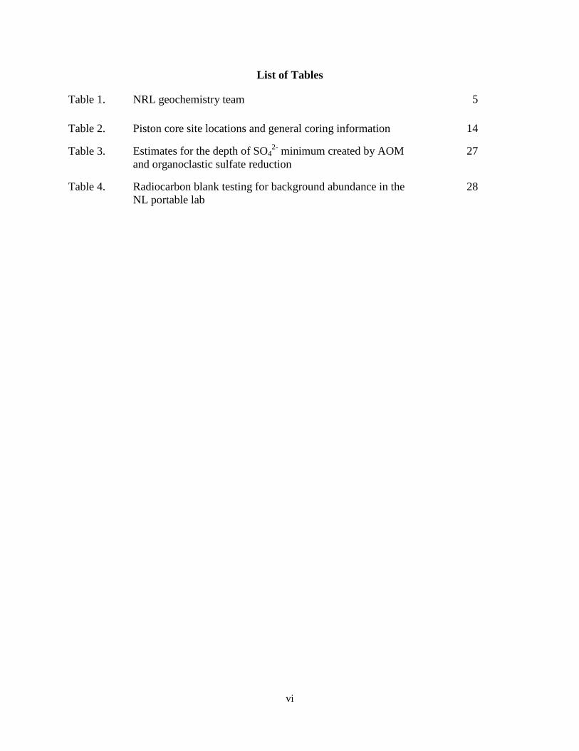
List of Tables
Table 1. NRL geochemistry team 5
Table 2. Piston core site locations and general coring information 14
Table 3. Estimates for the depth of SO42-
minimum created by AOM
and organoclastic sulfate reduction
27
Table 4. Radiocarbon blank testing for background abundance in the
NL portable lab
28
1
I. Overview
This document reviews NRL’s contribution to an international research expedition aboard
the RV Sonne (SO226) on the Chatham Rise, off the eastern coast of New Zealand in February
2013. The overall objective of this project is to determine the association of methane (CH4)
hydrate dissociation with pockmark formation on the Chatham Rise during previous climate
cycles. NRL participated in Leg 2 of the expedition (SO226-2). The NRL contribution to this
project includes the following:
Paleogeochemical assessment of pockmark formation on the Chatham Rise.
Comparison of pockmark regions with active flux of deep sediment CH4 to pockmark
sites with no current day CH4 flux.
Estimation of present-day CH4 flux to shallow sediments and its biogeochemical
contribution to organic and inorganic carbon pools using stable carbon isotope
distributions.
Natural abundance radiocarbon isotope analysis will be used to assess the past vertical
flux of CH4.
Assess carbon deposition and redistribution and paleoceanographic conditions using
sediment 230Th, 210Pb, and 231Pa.
To address these objectives, piston coring and multi-coring was conducted at four locations
with different seismic, multibeam and physical profiles. Prior to SO226, seismic and mutibeam
data were obtained by the University of Auckland and IFM-Geomar which helped to identify
broad study areas. Seismic and multibeam data collected on Leg 1(SO226-1) helped to identify
specific coring locations. These target areas were determined based on the seafloor morphology
and seismic data interpretation of shallow sediments. More specifically, coring locations were _______________
Manuscript approved April 5, 2013.

2
selected in where seismic profiles suggested high vertical CH4 fluxes to the shallow sediment
and at sites that were predicted to have low or non-existent vertical CH4 fluxes. Sediment cores
were also collected in the same locations for paleogeochemical analyses which will be completed
by Helen Neil at NIWA in Wellington, NZ. The final assessment of these sediments will require
integration of geophysical, geological and geochemical data. A weekly overview of Leg
1(SO226-1) and Leg 2 (SO226-2) is presented in Appendix 1.
II. Introduction
Methane hydrate distribution and abundance are key topics in climate change and
alternative energy research. Vast amounts of CH4, a potent greenhouse gas, are stored in the
Earth as ice-like gas hydrates, which are stable at the moderately high pressures and low
temperatures typically found close to the seafloor in deepwater sediments. The role of CH4
hydrates in climate change is poorly understood and there are concerns that changes in sea level
and ocean temperature as a result of climate fluctuations may lead to a release of significant
amounts of CH4 from gas hydrates. The result may lead to ocean acidification and potentially
accelerate climate change. Gas hydrates in sediments close to the top of gas hydrate stability
zone in ocean sediments are predicted to be particularly vulnerable.
While the Arctic is a primary focus for understanding climate change, researchers (New
Zealand and Germany) have discovered a >20,000 km2 region on the southern flank of the
Chatham Rise, east of New Zealand, that is covered by seafloor depressions interpreted to be
gas-escape features. Parasound sub-bottom profiles show a reflection that may constitute a
bottom simulating reflection (BSR) at the base of gas hydrate stability (BGHS) zone, suggesting
a link between the pockmarks and gas hydrates. Intriguingly, the Parasound data also reveal
buried pockmarks at horizons that appear to mark glaciation peaks. The hypothesis for this
3
research is that these depressions were formed as a result of CH4 release from destabilizing
hydrates during glacial-interglacial cycles. The estimated amount of CH4 is substantial, ~7 Tg
from one of the largest features (Davy et al., 2010). These findings may constitute the clearest
evidence to date linking gas hydrate dissociation and glacial climate fluctuations. Our research
plan focuses on studying the response of oceanic gas hydrates to climate fluctuations by
investigating the formation mechanisms of these seafloor depressions, their links to destabilizing
gas hydrates, and implications for CH4 release into the ocean and perhaps atmosphere.
This expedition was a collaborative effort between scientists from New Zealand, the
USA, and Europe and is a contribution to a funded New Zealand Marsden full research proposal:
“Uncorking the hydrate bottle: Release of CH4 from melting gas hydrates during glacial cycles
on the Chatham Rise, New Zealand” with Dr. Ingo Pecher as the Principal Investigator.
Geochemical analysis of shallow sediment will assist in the interpretation of seismic data across
Chatham Rise pockmarks to determine of the influence of climate change on CH4 hydrate
stability and subsequent vertical gas migration. Interpretation of geophysical, geologic and
geochemical data focused on the CH4 flux during the past interglacial period. Assessment
beyond this period will depend on the sedimentation rates measured at the 4 coring locations.
4
III. Site Description
This study compares three areas on the Chatham Rise east of New Zealand (Figure 1).
This location was selected based on a survey of a 20,000 km2 region on the southern flank of the
Rise that is covered by seafloor depressions that were interpreted as gas-escape features (Davy et
al., 2010). In that study, three classes of seafloor depressions were observed: 1) sub-circular
features that resemble typical pockmarks, ~ 150 m across and up to 8 m deep in water depths of
500-700 m, 2) Irregular depressions up to 5 km across and 150 m deep located in water depths of
800-1100 m and 3) shallower pockmarks close to the current top of the gas hydrate stability
(TGHS) zone in water column depths of ~ 550 m. At this location parasound sub-bottom
profiles suggested a reflection that may constitute a bottom simulating reflection (BSR) at the
base of gas hydrate stability (BGHS) which was interpreted to be a link between the pockmarks
and gas hydrates. Parasound data also revealed buried pockmarks at horizons that coincided
with glaciation peaks (Davy et al., 2010). Core site were selected based on findings from this
survey, a review of currently available geophysical data as well as seismic an multi-beam
profiles generated on this expedition. BSRs, that would indicate the BGHS, were not observed
in any of the profiles. The selection of core sites was based on seismic reflections suggesting
high sedimentation, sediment focusing and scouring, and sites showing evidence of vertical fluid
migration.
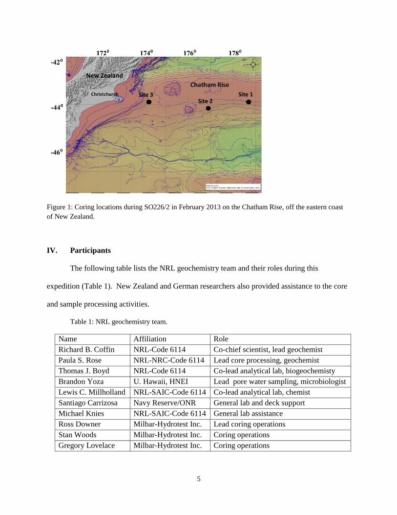
5
Figure 1: Coring locations during SO226/2 in February 2013 on the Chatham Rise, off the eastern coast
of New Zealand.
IV. Participants
The following table lists the NRL geochemistry team and their roles during this
expedition (Table 1). New Zealand and German researchers also provided assistance to the core
and sample processing activities.
Table 1: NRL geochemistry team.
Name Affiliation Role
Richard B. Coffin NRL-Code 6114 Co-chief scientist, lead geochemist
Paula S. Rose NRL-NRC-Code 6114 Lead core processing, geochemist
Thomas J. Boyd NRL-Code 6114 Co-lead analytical lab, biogeochemisty
Brandon Yoza U. Hawaii, HNEI Lead pore water sampling, microbiologist
Lewis C. Millholland NRL-SAIC-Code 6114 Co-lead analytical lab, chemist
Santiago Carrizosa Navy Reserve/ONR General lab and deck support
Michael Knies NRL-SAIC-Code 6114 General lab assistance
Ross Downer Milbar-Hydrotest Inc. Lead coring operations
Stan Woods Milbar-Hydrotest Inc. Coring operations
Gregory Lovelace Milbar-Hydrotest Inc. Coring operations
Site 1Site 2
Site 3
6
V. Methods
A. Radiocarbon Natural Abundance Analysis – Background radiocarbon wipe tests were
conducted to determine levels of radiocarbon present in the work areas. Wipe tests were done in
different shipboard laboratories, work and storage areas and in the NRL portable lab van (Table
4). Pre-combusted Whatmann QMA filters (25 mm diameter) were soaked in isopropanol and
wiped on an area ~ 1 m2 at each location. At the GNS radioisotope laboratory, the filters were
folded and placed in combustion tube with carrier after drying in vacuum oven. CO2 was
generated by sealed tube combustion tube. Sample and data processing are described by Stuiver
and Polach (1977). The blank corrected, fraction modern was normalized to 13
C = -25‰
defined by Donahue et al. (1990).
B. Coring – Coring operations included sediment piston coring and multi-coring.
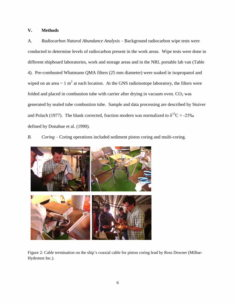
Figure 2: Cable termination on the ship’s coaxial cable for piston coring lead by Ross Downer (Milbar-
Hydrotest Inc.).

7
1. Piston Core Installation and Operations – For piston core cable termination, an
Electroline ME200 termination was used and tested on deck for a 10,000 pound pull (Figure 2).
Re-termination was conducted 4 times while at sea, after losing a piston corer and after kinking
the cable during retrieval operations.
Figure 3: Piston coring conducted off the starboard delivery platform. Core location was
monitored with a wire mounted transponder.
8
Piston coring was conducted using a 1400 kg head weight with a changeable pipe
assembly for 6 and 9 m cores (Figure 3). The barrels used for coring were N90 high strength
alloy, which allows the barrels to bend 45⁰ before breaking. Core liners were 7.3 cm OD x 6.7
cm ID x 305 cm L and composed of cellulose acetate butyrate . The trigger arm was equipped
with a 68 kg weight and set for a 4 m drop. The 9 m barrels were used for the majority of the
deployments. Coring locations, date and time of collection are presented in Appendix 2.
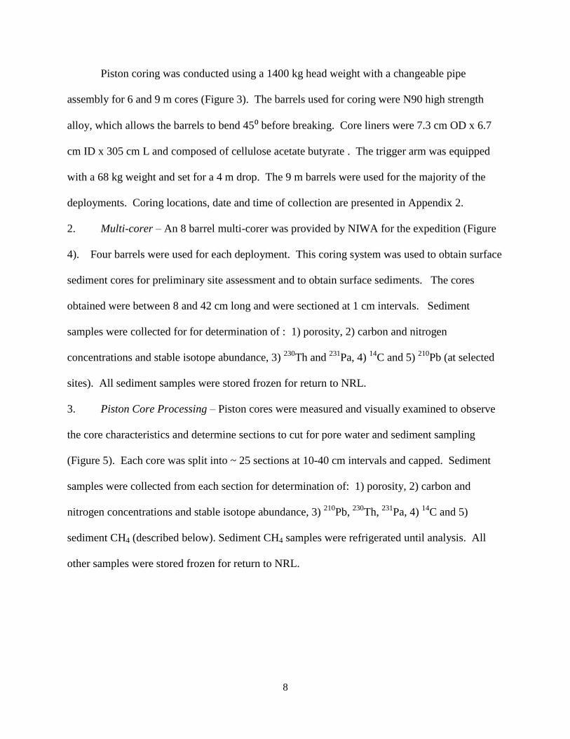
2. Multi-corer – An 8 barrel multi-corer was provided by NIWA for the expedition (Figure
4). Four barrels were used for each deployment. This coring system was used to obtain surface
sediment cores for preliminary site assessment and to obtain surface sediments. The cores
obtained were between 8 and 42 cm long and were sectioned at 1 cm intervals. Sediment
samples were collected for for determination of : 1) porosity, 2) carbon and nitrogen
concentrations and stable isotope abundance, 3) 230
Th and 231
Pa, 4) 14
C and 5) 210
Pb (at selected
sites). All sediment samples were stored frozen for return to NRL.
3. Piston Core Processing – Piston cores were measured and visually examined to observe
the core characteristics and determine sections to cut for pore water and sediment sampling
(Figure 5). Each core was split into ~ 25 sections at 10-40 cm intervals and capped. Sediment
samples were collected from each section for determination of: 1) porosity, 2) carbon and
nitrogen concentrations and stable isotope abundance, 3) 210
Pb, 230
Th, 231
Pa, 4) 14
C and 5)
sediment CH4 (described below). Sediment CH4 samples were refrigerated until analysis. All
other samples were stored frozen for return to NRL.
9
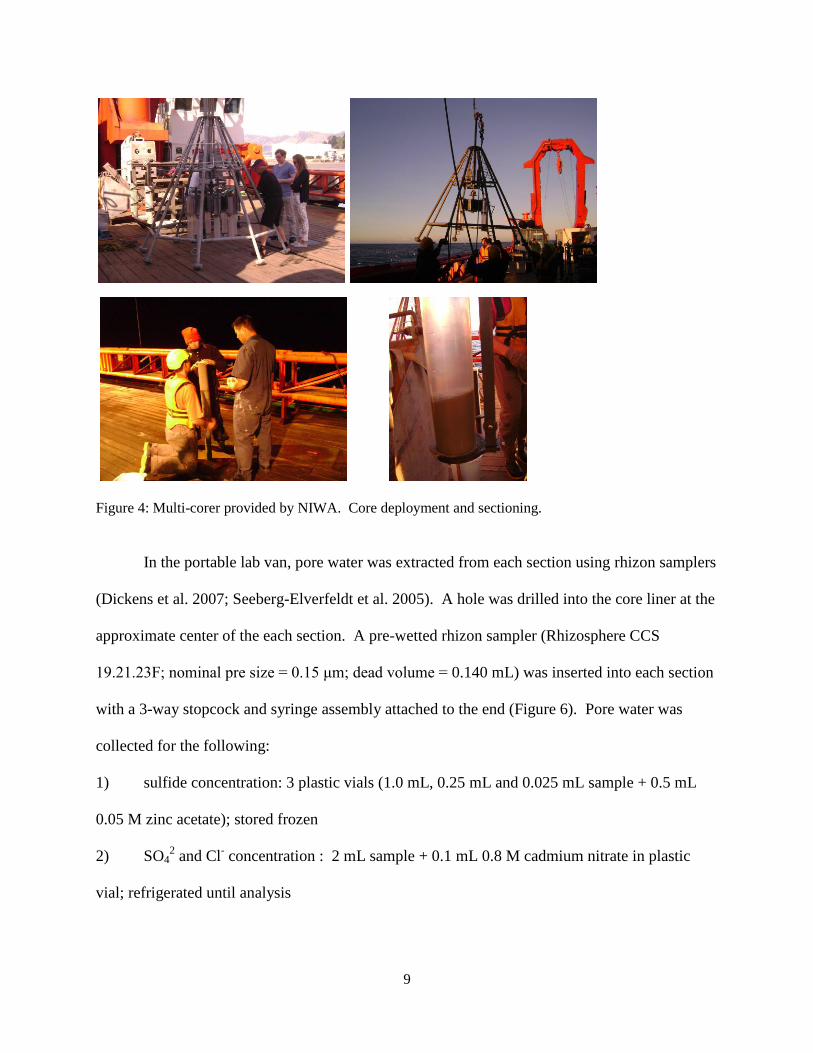
Figure 4: Multi-corer provided by NIWA. Core deployment and sectioning.
In the portable lab van, pore water was extracted from each section using rhizon samplers
(Dickens et al. 2007; Seeberg-Elverfeldt et al. 2005). A hole was drilled into the core liner at the
approximate center of the each section. A pre-wetted rhizon sampler (Rhizosphere CCS
19.21.23F; nominal pre size = 0.15 μm; dead volume = 0.140 mL) was inserted into each section
with a 3-way stopcock and syringe assembly attached to the end (Figure 6). Pore water was
collected for the following:
1) sulfide concentration: 3 plastic vials (1.0 mL, 0.25 mL and 0.025 mL sample + 0.5 mL
0.05 M zinc acetate); stored frozen
2) SO42 and Cl
- concentration : 2 mL sample + 0.1 mL 0.8 M cadmium nitrate in plastic
vial; refrigerated until analysis
10
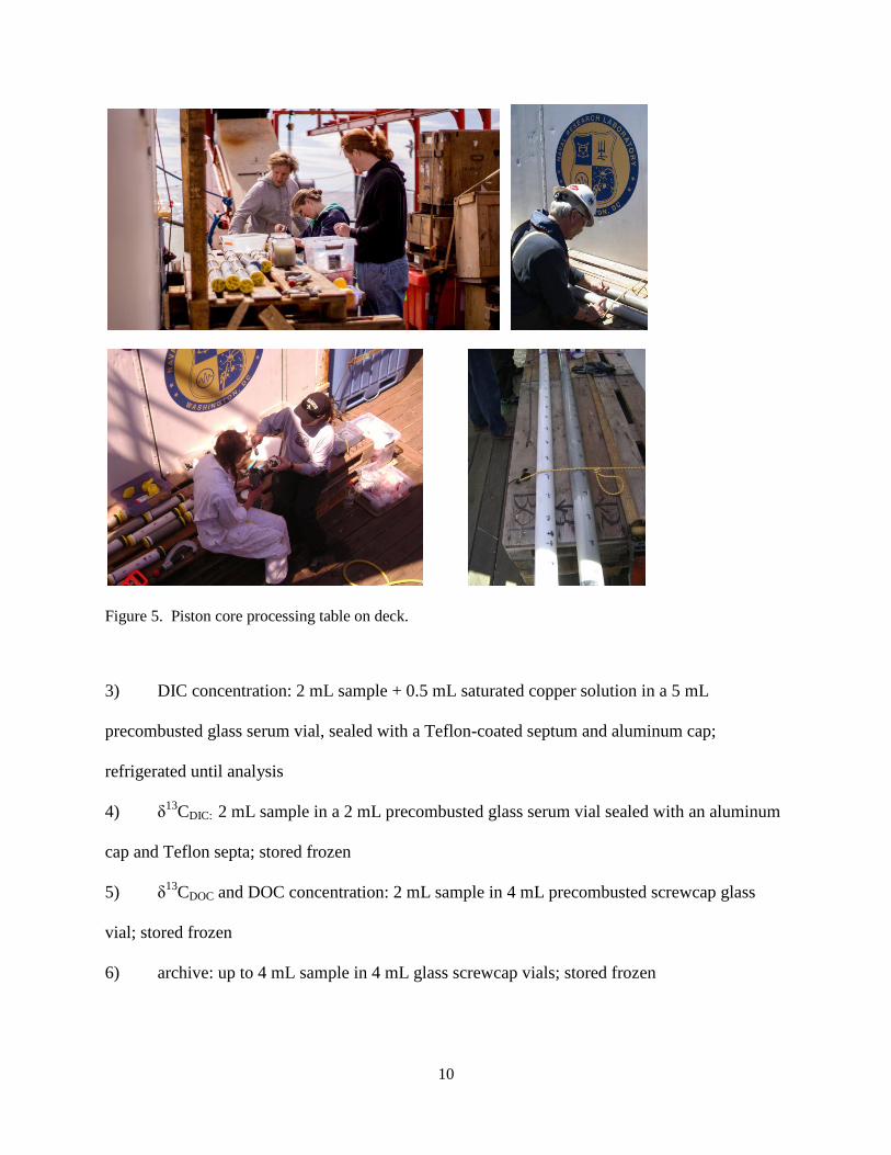
Figure 5. Piston core processing table on deck.
3) DIC concentration: 2 mL sample + 0.5 mL saturated copper solution in a 5 mL
precombusted glass serum vial, sealed with a Teflon-coated septum and aluminum cap;
refrigerated until analysis
4) δ13
CDIC: 2 mL sample in a 2 mL precombusted glass serum vial sealed with an aluminum
cap and Teflon septa; stored frozen
5) δ13
CDOC and DOC concentration: 2 mL sample in 4 mL precombusted screwcap glass
vial; stored frozen
6) archive: up to 4 mL sample in 4 mL glass screwcap vials; stored frozen

11
Figure 6: Pore water sampling using Rhizon samplers and distribution of samples.
C. On board laboratory analysis
1. Pore water sulfate and chloride - Samples were diluted 1:50 (vol/vol) and sulfate (SO42)
and chloride (Cl-) concentrations were measured with a Dionex DX-120 ion chromatograph
(Figure 7) equipped with an AS-9HC column and checked against a 1:50 diluted IAPSO
seawater standard (28.9 mM SO42-
, 559 mM Cl-). Sulfate and Cl
- concentrations are presented in
millimolar units (mM). Limits of detection are <0.1 mM.
2. Dissolved inorganic carbon- Dissolved inorganic carbon (DIC) concentrations were
measured using a UIC coulometer (Figure 8) and standardized against a certified reference
material (CRM, Batch 58). DIC concentrations are presented in mM.
3. Sediment methane – Three mL sediment plugs were removed from each core section
using a syringe with the end cut off. The sediment plug was placed in a 20 mL serum vial,
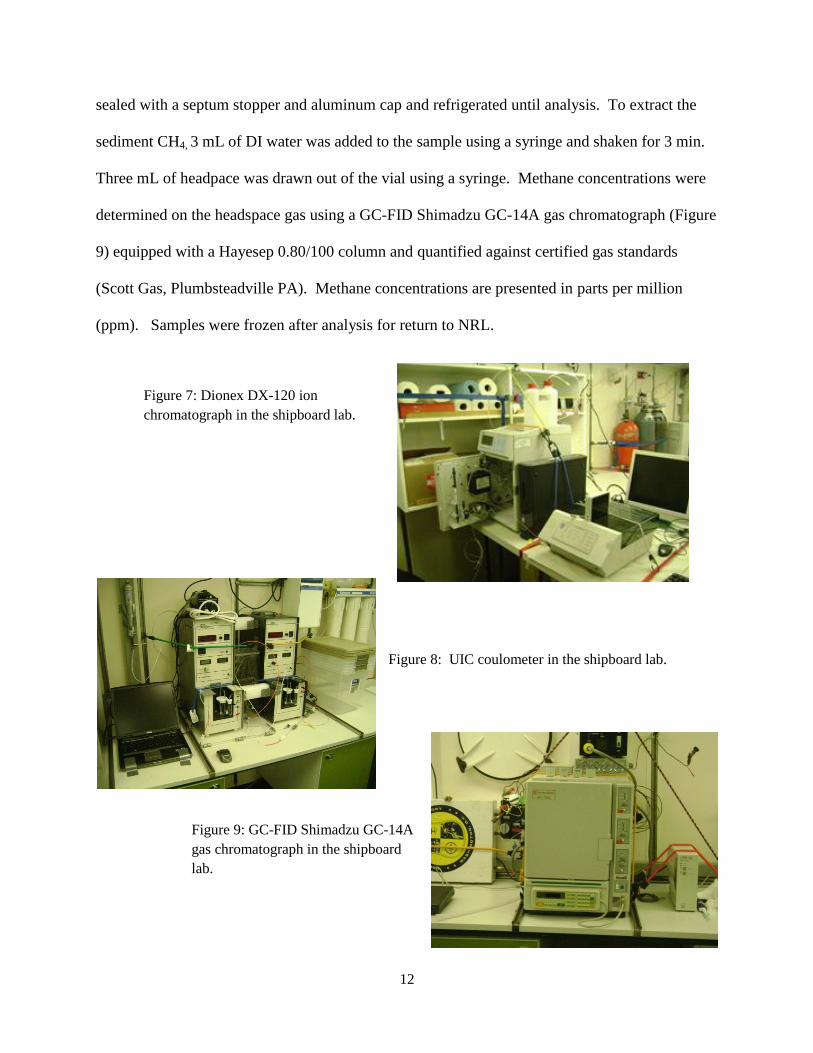
12
sealed with a septum stopper and aluminum cap and refrigerated until analysis. To extract the
sediment CH4, 3 mL of DI water was added to the sample using a syringe and shaken for 3 min.
Three mL of headpace was drawn out of the vial using a syringe. Methane concentrations were
determined on the headspace gas using a GC-FID Shimadzu GC-14A gas chromatograph (Figure
9) equipped with a Hayesep 0.80/100 column and quantified against certified gas standards
(Scott Gas, Plumbsteadville PA). Methane concentrations are presented in parts per million
(ppm). Samples were frozen after analysis for return to NRL.
Figure 7: Dionex DX-120 ion
chromatograph in the shipboard lab.
Figure 8: UIC coulometer in the shipboard lab.
Figure 9: GC-FID Shimadzu GC-14A
gas chromatograph in the shipboard
lab.

13
VI. Initial Results
This research expedition focused on pockmarks in three different areas of the Chatham
Rise (Site 1, Site 2, Site 3) with the intention of studying past and currently active vertical CH4
migration and the contribution to shallow sediment carbon cycling (Figure 1; Table 2). Data
presented in this report is a summary of the analyses completed onboard. Results are intended to
organize the selection of samples for radiocarbon, stable carbon and radioisotopes (230
Th, 210
Pb,
and 231
Pa) to date (~20,000 years back) vertical CH4 fluxes and subsequent shallow sediment
carbon cycling. Data presented in this report includes Cl- to assess CH4 hydrate dissociation in
cores, or vertical and horizontal transport of pore water. Sulfate, CH4 and DIC were reviewed to
provide estimate of current day vertical gas fluxes. Sediment CH4 was at near the limits of
detection in all cores, measured concentrations are presented in Appendix 3 and are not
discussed in this text.

14
Table 2: Piston core site locations and general coring information. Not all of the cores listed are presented
in this report. Early cores were for system testing and late cores were lost due to sea floor characteristics.
Core LogTotal # of
Cores: 37 Total Length of Core Retrieved (meters): 154.95
Core Number
Date
UTC
Time at
Trigger
UTC
Transponder
Latitude
Transponder
Longitude
Water
Depth
Meters
Cable Out
at
Time of
Trigger
Meters
Est. Max
Tension
on Pullout
kiloNewtons
Core
Length
Meters Notes
Water
Depth -
Cable
Out at
Trigger
Percent
Recovery
Estimated
Core
Length
Est. Max
Tension
on Pullout
Pounds
30-2-PC9 10-Feb-13 22:45 44° 6.03 S 178° 39.99 E 873 854 56.6 5.74 19 63.78% 5.21 12,724
33-1-PC9 13-Feb-13 2:30 44° 5.72' S 178° 31.25 E 899 884 63.1 3.05 15 33.89% 5.01 14,186
33-2-PC9 13-Feb-13 4:30 44° 5.72' S 178° 31.26 E 900 87 4.2 46.67% 4.25 19,558
33-3-PC6 13-Feb-13 6:30 44° 5.73 S 178° 31.2 E 900 75.7 4.07 67.83% 4.61 17,018
34-1-PC6 13-Feb-13 8:38 44° 5.69 S 178° 32.30 E 976 963 152 0
Whole assembly
stuck, snapped
cable. Lost bomb, 3
stands of pipe, tip,
and piston 13 0.00% 2.20 34,171
44-1-PC9 14-Feb-13 21:38 43° 58.85 S 178° 48.88 E 680 661 41.1 6.04 19 67.11% 5.70 9,240
45-1-PC9 15-Feb-13 0:06 43° 58.86 S 178° 47.57 E 749 732 35.9 6.71 17 74.56% 5.86 8,071
45-2-PC9 15-Feb-13 2:40 43° 58.81 S 178° 47.63 E 743 729 38.7 6.86 14 76.22% 5.78 8,700
46-1-PC9 15-Feb-13 4:29 43° 58.90 S 178° 46.95 E 810 798 26.2 0
Broke off 3rd
barrel, No
recovery 12 0.00% 6.17 5,890
47-1-PC9 15-Feb-13 6:50 43° 58.91 S 178° 46.74 E 825 807 28 0
Broke off 3rd
barrel, No
recovery 18 0.00% 6.11 6,295
51-2-PC9 15-Feb-13 16:46 43° 58.20 S 178° 46.82 E 770 750 47.6 6.48 20 72.00% 5.50 10,701
52-1-PC9 15-Feb-13 19:49 43° 57.94 S 178° 47.61 E 702 686 41.7 6.42 16 71.33% 5.68 9,375
53-1-PC9 15-Feb-13 22:09 43° 58.70 S 178° 47.89 E 736 713 32.1 6.15
Top section of core
liner stuck in
barrel 23 68.33% 5.99 7,216
54-1-PC9 16-Feb-13 0:29 43° 58.89 S 178° 47.22 E 785 766 49.4 6.6 19 73.33% 5.44 11,106
57-1-GC3 16-Feb-13 22:30 43° 56.915 S 178° 35.122 E 631 628 41.7 1.87 3 62.33% 5.68 9,375
58-1-GC3 17-Feb-13 0:50 43° 5.997 S 178° 31.52 E 906 906 32.1 0
No recovery, very
sandy 0 0.00% 5.99 7,216
59-1-GC3 17-Feb-13 2:42 44° 7.603 S 178° 36.224 E 928 921 35.7 0
No recovery, very
sandy 7 0.00% 5.87 8,026
60-1-GC3 17-Feb-13 4:33 44° 11.239 S 178° 36.338 E 1035 1030 26.2 0
No recovery, very
sandy 5 0.00% 6.17 5,890
73-2-PC9 20-Feb-13 15:03 44° 14.37 S 177° 8.47 E 964 944 49.4 6.41 20 71.22% 5.44 11,106
74-1-PC9 20-Feb-13 17:02 44° 14.37 S 177° 8.55 E 960 943 46.4 6.07 17 67.44% 5.53 10,431
75-1-PC9 20-Feb-13 19:38 44° 14.37 S 177° 9.07 E 968 94 31.5 874 6.00 7,082
75-2-PC9 20-Feb-13 21:33 44° 14.39 S 177° 8.97 E 968 949 38.1 6.65 19 73.89% 5.80 8,565
76-1-PC9 21-Feb-13 0:04 44° 14.37 S 177° 10.41 E 970 948 44.7 5.89 22 65.44% 5.59 10,049
76-2-PC9 21-Feb-13 2:03 44° 14.36 S 177° 10.41 E 970 947 39.9 6.48 23 72.00% 5.74 8,970
77-1-PC9 21-Feb-13 4:05 44° 14.36 S 177° 11.16 E 940 919 39.3 6.53 21 72.56% 5.76 8,835
77-2-PC9 21-Feb-13 6:14 44° 14.37 S 177° 11.17 E 936 919 46.6 6.28 17 69.78% 5.53 10,476
77-3-PC9 21-Feb-13 7:56 44° 14.37 S 177° 11.17 E 936 918 38.1 18 5.80 8,565
82-3-PC9 21-Feb-13 21:05 44° 18.49 S 177° 2.37 E 1023 1002 33.9 6.25 21 69.44% 5.93 7,621
83-1-PC9 21-Feb-13 22:51 44° 18.35 S 177° 2.50 E 1013 999 46.4 6.38 14 70.89% 5.53 10,431
84-1-PC9 22-Feb-13 0:52 44° 18.26 S 177° 2.59 E 1019 999 48.2 6.64 20 73.78% 5.48 10,836
85-1-PC9 22-Feb-13 3:01 44° 17.48 S 177° 3.42 E 975 955 34.5 20 5.91 7,756
85-2-PC9 22-Feb-13 5:42 44° 17.54 S 177° 3.43 E 975 954 40.5 21 5.72 9,105
94-3-PC9 25-Feb-13 16:55 43° 59.43 S 174° 28.05 E 569 554 35.7 4.4
Shot 1916 - Paleo
core 15 48.89% 5.87 8,026
94-4-PC9 25-Feb-13 19:16 43° 59.44 S 174° 28.04 E 569 554 32.7 6.15
Shot 1916 Geotech
core 15 68.33% 5.97 7,351
94-5-PC9 25-Feb-13 20:39 43° 59.43 S 174° 28.09 E 569 553 35.7 6.57
Shot 1916 -
Geochem core 16 73.00% 5.87 8,026
95-1-PC9 25-Feb-13 22:05 43° 59.26 S 174° 27.93 E 568 553 31.5 4.27 Shot 2155 15 47.44% 6.00 7,082
96-1-PC9 26-Feb-13 0:05 43° 59.24 S 174° 27.92 E 569 557 35.7 5.79 12 64.33% 5.87 8,026
97-1-PC9 26-Feb-13 1:25 43° 59.17 S 174° 27.86 E 569 554 30.4 4.28 15 47.56% 6.04 6,834
98-1-PC9 26-Feb-13 3:08 44° 0.13 S 174° 28.63 E 571 568 46.4 2.41
Shot 964 - Geotech
core 3 26.78% 5.53 10,431
98-2-PC9 26-Feb-13 4:32 44° 0.12 S 174° 28.64 E 571 561 53 5.85
Station Name on
Display showed 98,
not 98/2 10 65.00% 5.32 11,915
99-1-PC9 26-Feb-13 6:30 43° 58.95 S 174° 27.68 E 575 560 28 0
Broke off 3rd
barrel, No
recovery 15 0.00% 6.11 6,295
100-1-PC9 26-Feb-13 8:12 43° 58.85 S 174° 27.59 E 568 554 30.4
Imploded middle
core liner 14 6.04 6,834
101-1-PC9 26-Feb-13 10:05 44° 1.17 S 174° 27.06 E 572 557 23.8 Bent third barrel 15 6.25 5,350
15
A. Site 1
Core site 1 is located northeast of a series of pockmarks on the Chatham Rise at water
depths that range from 686 to 807 meters (Figure 10). Sediment characteristics and the need to
obtain cores at least 4 meters deep for age dating resulted in the selection of coring sites to the
east of the pockmarks. Sand to gravel and chalk sediment to the west resulted in losing one
piston corer and breaking two core barrels. After difficulties with piston coring, multi-coring
was used to assess the potential to retrieve deep piston cores. Multi-core samples are also used
to obtain modern data sediment to assess the current sedimentation rate relative to the vertical
CH4 flux.
Figure 10: Site 1 coring locations on the eastern side of the pockmark. Control cores
(PC31 and PC33, not presented in this report) are also shown off the pockmark.
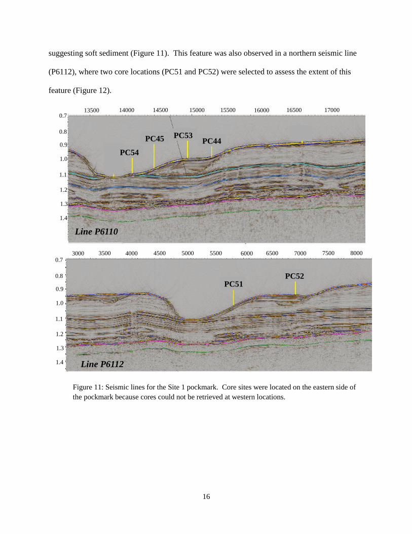
Seismic data from Site 1 was suggested modern vertical gas migration (Figure 12).
PC54, PC45, PC53 and PC44 were taken on the south eastern side of Site 1. Line P6110 was
selected due to deep reflection patterns indicative of and strong shallow seismic reflections
Depth (m)
-437.5
-500.0
-562.5
-812.5
-687.5
-625.0
-875.0
-750.0
-1000.0
-937.5
-1062.5
178⁰30’ 178⁰35’ 178⁰40’ 178⁰45’
-43⁰55’
-44⁰00’
-44⁰05’ PC33
PC46PC53
PC44
PC52
PC54
PC51
PC31
16
suggesting soft sediment (Figure 11). This feature was also observed in a northern seismic line
(P6112), where two core locations (PC51 and PC52) were selected to assess the extent of this
feature (Figure 12).
Figure 11: Seismic lines for the Site 1 pockmark. Core sites were located on the eastern side of
the pockmark because cores could not be retrieved at western locations.
0.7
1.0
1.4
0.8
0.9
1.1
1.2
1.3
PC44
Line P6110
PC45
13500 14000 14500 15000 15500 16000 1700016500
PC54
PC53
3000 3500 4000 4500 5000 5500 6000 6500 7000 7500 80000.7
1.0
1.4
0.8
0.9
1.1
1.2
1.3
Line P6112
PC51PC52

17
Figure 12: Pore water SO42-
, Cl- and DIC profiles in cores from the eastern side
of the pockmark at Site 1.
Geochemical evaluation of the eastern lines across the site 1 pockmark found low
background sediment CH4 and no higher molecular weight gases (Appendix 3). Data presented
for the field assessment of the core pore water includes SO42-
, Cl-, and DIC (Figure 12). The
range in SO42-
concentrations at this location was 22.9 to 29.2 mM. The general trend for SO42-
profiles at all locations in this region is moderate to no decrease in concentration with depth. The
linear trend in the SO42-
profiles, with no rapid depletion in the shallow sediment characteristic of
labile organoclastic cycling, could suggest anaerobic oxidation of CH4 (AOM) is responsible for
the decline in concentration. However, sediment CH4 concentrations through the cores were
Cl- (mM)
300 350 400 450 500 550 600
cm
bsf
0
200
400
600
800
44-1-PC9
45-2-PC9
51-2-PC9
52-1-PC9
53-1-PC9
54-1-PC9
SO4
2- (mM)
10 15 20 25 30
cm
bsf
0
200
400
600
800
44-1-PC9
45-2-PC9
51-2-PC9
52-1-PC9
53-1-PC9
54-1-PC9
DIC (mM)
0 2 4 6 8 10 12 14
cm
bsf
0
200
400
600
800
44-1-PC9
45-2-PC9
51-2-PC9
52-1-PC9
53-1-PC9
54-1-PC9

18
slightly above the limits of detection and indicate that AOM was beyond the core penetration
depth. Laboratory analyses of δ13
CDIC and sulfide concentrations will be measured to assess
AOM. Chloride concentrations for cores near the Site 1 pockmark ranged from 451 to 543 mM
(Figure 13). Generally, the Cl- profiles were relatively constant with depth and concentrations
were near seawater values. However, Cl- in PC51 was observed to be lower through the entire
core and decline to the minimum observed value at depth. Another general observation of the
Cl- profiles was a the similarity to the SO4
2- profiles, suggesting low SO4
2- cycling, assuming Cl
-
is a conservative tracer (Figure 12). Pore water DIC concentrations ranged from 2.1 to 5.2 mM
with shallow sediment concentrations consistently near the seawater concentration with gradual
increases observed down core. PC54 was observed to have the highest DIC concentration
toward the bottom of the core. This inverse relationship could indicate low AOM or
organoclastic SO42-
reduction through the core.
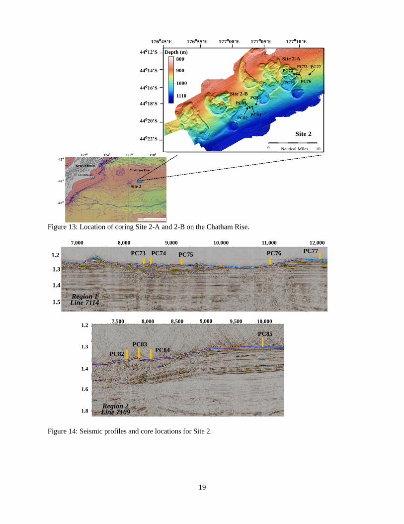
B. Site 2
Site 2 was located south of Site 1 in water depths ranging from ~ 1000 to 1100 m
(Figure 13). In this area, there were two coring locations: Site 2-A (Seismic Line 7114, Figure
14) and Site 2-B (Seismic Line 7109, Figure 14). Selection of core these sites was based on
seismic profiles interpreted to show shallow sediment accumulation and vertical fluid fluxes.
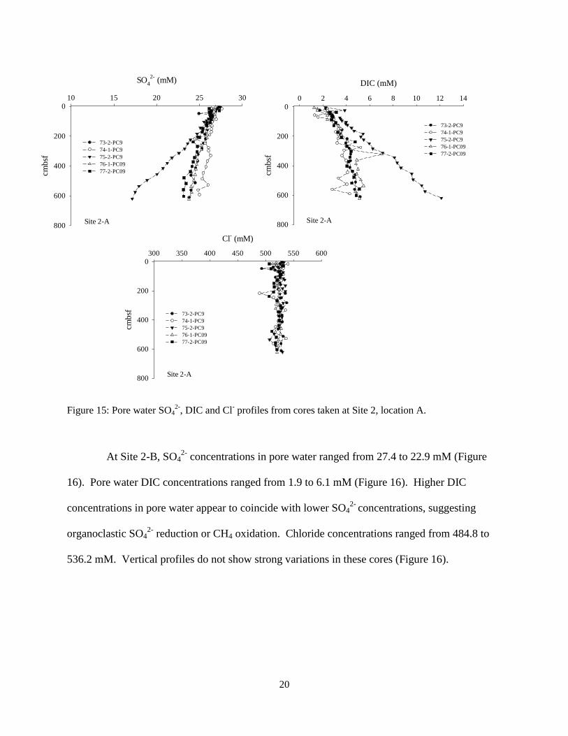
Pore water SO42-
and DIC concentrations in the cores ranged from 17.1 to 27.6 mM and 1.3 to
12.1 mM, respectively. PC75 was observed to have the greatest decrease in SO42-
and increase
of DIC concentration suggesting AOM or organoclastic SO42-
reduction (Figure 15). In Site 2-A
cores, pore water Cl- concentrations ranged from 489.7 to 540.1 mM. In general, profiles were
conservative with no vertical patterns; however, there were a couple of points with lower
concentrations (Figure 15).
19
Figure 13: Location of coring Site 2-A and 2-B on the Chatham Rise.
Figure 14: Seismic profiles and core locations for Site 2.
Line 7109Region 2
PC85
PC84PC83
PC82
1.2
1.3
1.4
1.6
1.8
10,0009,5009,0008,5008,0007,500
PC73 PC74 PC75 PC76 PC77
12,00011,0009,000 10,000
1.2
7,000 8,000
1.4
1.5
1.3
Line 7114Region 1
176⁰45’E 176⁰55’E 177⁰00’E 177⁰05’E 177⁰10’E
44⁰12’S
44⁰14’S
44⁰16’S
44⁰18’S
44⁰20’S
44⁰22’SSite 2
PC73
PC74
PC75
PC76
PC77
PC82
PC83
PC84
PC85
0 Nautical Miles 10
Site 2
Depth (m)
1000
900
800
Site 2-B
Site 2-A
1110
20
Figure 15: Pore water SO42-
, DIC and Cl- profiles from cores taken at Site 2, location A.
At Site 2-B, SO42-
concentrations in pore water ranged from 27.4 to 22.9 mM (Figure
16). Pore water DIC concentrations ranged from 1.9 to 6.1 mM (Figure 16). Higher DIC
concentrations in pore water appear to coincide with lower SO42-
concentrations, suggesting
organoclastic SO42-
reduction or CH4 oxidation. Chloride concentrations ranged from 484.8 to
536.2 mM. Vertical profiles do not show strong variations in these cores (Figure 16).
Site 2-A
DIC (mM)
0 2 4 6 8 10 12 14
cmb
sf
0
200
400
600
800
73-2-PC9
74-1-PC9
75-2-PC9
76-1-PC09
77-2-PC09
Site 2-A
SO4
2- (mM)
10 15 20 25 30
cm
bsf
0
200
400
600
800
73-2-PC9
74-1-PC9
75-2-PC9
76-1-PC09
77-2-PC09
Site 2-A
Cl- (mM)
300 350 400 450 500 550 600
cm
bsf
0
200
400
600
800
73-2-PC9
74-1-PC9
75-2-PC9
76-1-PC09
77-2-PC09

21
Figure 16: Pore water SO42-
, DIC and Cl- profiles from cores taken at Site 2, location B.
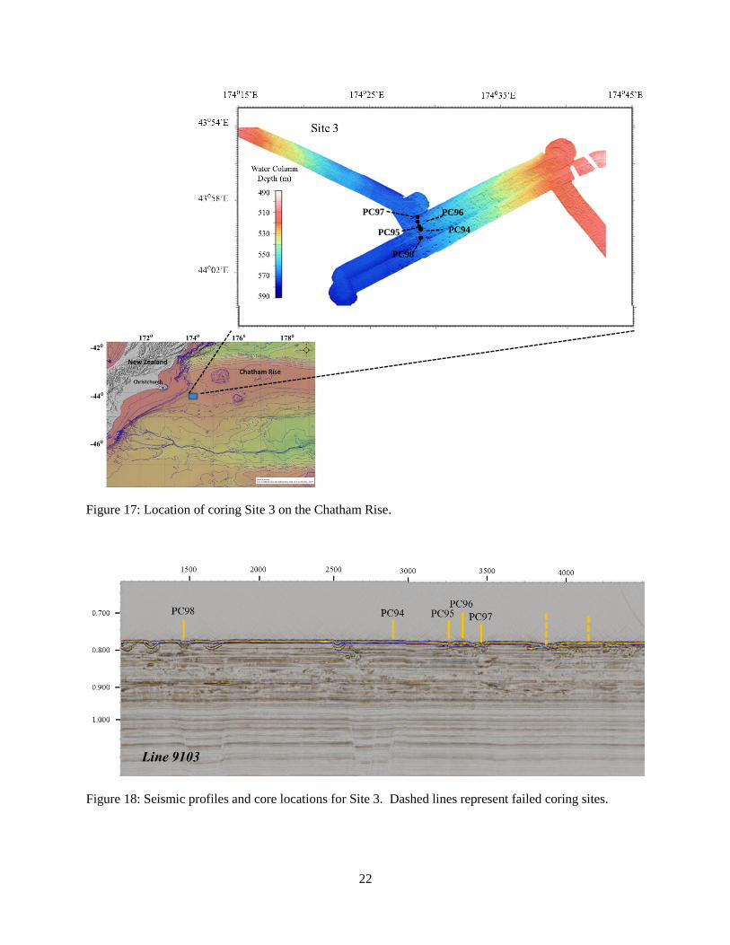
C. Site 3
Site 3 was located in a shallower region of Chatham Rise in water depths of ~ 570 m
(Figure 17). Multibeam patterns and seismic profiles showed a smaller pockmarks with a split
pattern below and disturbance in the bands that indicated vertical migration of fluids to the
surface (Figures 17 & 18). Three cores were collected in this location: one in center of the flow
pattern and the other two on the sides of the center point (Figure 18: PC95, PC96, PC97). PC94
was selected as a control core in a region that showed strong stratification in the seismic profile.
PC98 was located in the center of a small pockmark with a disruption in the seismic pattern
immediately below and a deep pathway into the sediment (Figure 18). Attempts to core at other
locations in this region resulted in breaking core barrels, separating the winch cable wires, and
minimal sediment samples.
Site 2-B
SO4
2- (mM)
10 15 20 25 30
cm
bsf
0
200
400
600
800
82-3-PC09
83-1-PC09
84-1-PC09
85-2-PC09
Site 2-B
DIC (mM)
0 2 4 6 8 10 12 14
cm
bsf
0
200
400
600
800
82-3-PC09
83-1-PC09
84-1-PC09
85-2-PC09
Site 2-B
Cl- (mM)
300 350 400 450 500 550 600
cm
bsf
0
200
400
600
800
82-3-PC09
83-1-PC09
84-1-PC09
85-2-PC09
22
Figure 17: Location of coring Site 3 on the Chatham Rise.
Figure 18: Seismic profiles and core locations for Site 3. Dashed lines represent failed coring sites.
PC94PC95
PC96PC97
PC98
23
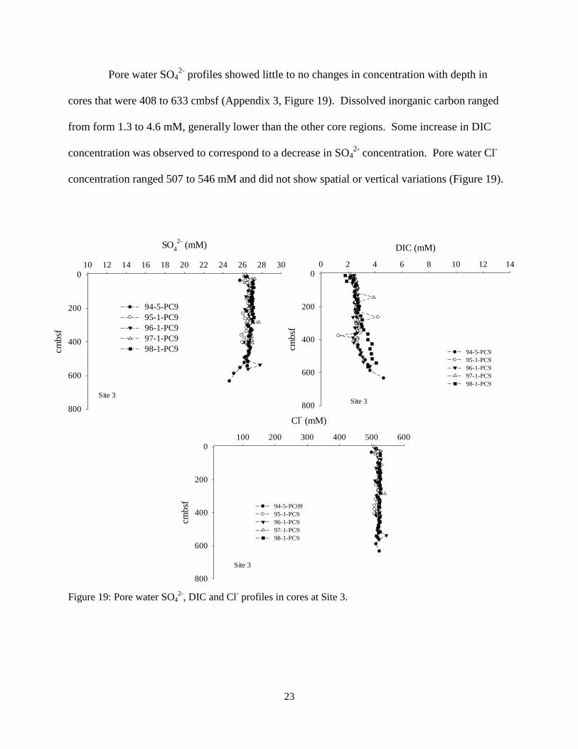
Pore water SO42-
profiles showed little to no changes in concentration with depth in
cores that were 408 to 633 cmbsf (Appendix 3, Figure 19). Dissolved inorganic carbon ranged
from form 1.3 to 4.6 mM, generally lower than the other core regions. Some increase in DIC
concentration was observed to correspond to a decrease in SO42-
concentration. Pore water Cl-
concentration ranged 507 to 546 mM and did not show spatial or vertical variations (Figure 19).
Figure 19: Pore water SO42-
, DIC and Cl- profiles in cores at Site 3.
Site 3
SO4
2- (mM)
10 12 14 16 18 20 22 24 26 28 30
cm
bsf
0
200
400
600
800
94-5-PC9
95-1-PC9
96-1-PC9
97-1-PC9
98-1-PC9
Site 3
DIC (mM)
0 2 4 6 8 10 12 14
cm
bsf
0
200
400
600
800
94-5-PC9
95-1-PC9
96-1-PC9
97-1-PC9
98-1-PC9
Site 3
Cl- (mM)
100 200 300 400 500 600
cm
bsf
0
200
400
600
800
94-5-PC09
95-1-PC9
96-1-PC9
97-1-PC9
98-1-PC9

24
D. Porewater Geochemistry Summary
Shallow sediment geochemical cycles that control porewater SO42-
and DIC are
assumed to be AOM or organoclastic SO42-
reduction. To evaluate the paleogeochemical CH4
availability and cycling in the shallow sediment there is a need to assess the current day shallow
sediment flux and cycling. Studies show that vertical CH4 fluxes can contribute up to 90% of the
shallow sediment organic and inorganic carbon pools (Coffin et al. submitted-A, submitted-B).
We summarized the potential modern-day CH4 input to this study by comparing sediment pore
water Cl- vs. SO4
2- concentrations (Figure 20) and SO4
2- vs. DIC concentrations (Figure 21) for
all of the cores in each region. It is assumed that Cl- is a conservative tracer for SO4
2- reduction
during AOM and organoclastic SO42-
reduction (Figure 20).
Figure 20: Comparison of the pore water SO42-
concentrations relative to Cl- concentrations in cores from
each region.
Cl- (mM)
440 460 480 500 520 540 560 580 600
SO
4
2- (m
M)
16
18
20
22
24
26
28
30
44-1-PC9
45-2-PC9
51-2-PC9
52-1-PC9
53-1-PC9
54-1-PC9
Site 1
Cl- (mM)
440 460 480 500 520 540 560 580 600
SO
4
2- (
mM
)
16
18
20
22
24
26
28
30
73-2-PC9
74-1-PC9
75-2-PC9
76-1-PC9
77-2-PC9
Cl- (mM)
440 460 480 500 520 540 560 580 600
SO
4
2- (
mM
)
16
18
20
22
24
26
28
30
82-3-PC9
83-1-PC9
84-1-PC9
85-2-PC9
Site 2B
Cl- (mM)
440 460 480 500 520 540 560 580 600
SO
4
2- (
mM
)
16
18
20
22
24
26
28
30
94-5-PC9
95-1-PC9
96-1-PC9
97-1-PC9
98-1-PC9
Site 3
Site 2A

25
In this evaluation, pore water SO42-
deviated from the linear Cl- profile at Sites 2A and 2B
relative to Sites 1 and 3, suggesting more active SO42-
cycling. We also assumed that DIC
concentrations in the pore water will increase through oxidation of CH4 or organic matter during
the SO42-
reduction to sulfide (Figure 21; Berner, 1964; Borowski et al., 1996; 1999). Cores
taken at Sites 2A and 2B also show a higher pore water DIC concentration relative to a decline in
SO42-
concentration.
Figure 21: Comparison of pore water SO42-
reduction relative to DIC production in the cores among the
sites.
Sulfate and DIC gradients in the sediments can be used to estimate oxidation of
autochthonous organic matter and upwardly diffusing CH4. We predict sediment depth for
depletion of SO42-
concentration to 0 mM using slope of the linear SO42-
profile (Table 3). These
SO4
2- (mM)
16 18 20 22 24 26 28 30
DIC
(mM
)
0
2
4
6
8
10
12
14
44-1-PC9
45-2-PC9
51-2-PC9
52-1-PC9
53-1-PC9
54-1-PC9
Site 1
SO4
2- (mM)
16 18 20 22 24 26 28 30
DIC
(m
M)
0
2
4
6
8
10
12
14
73-2-PC9
74-1-PC9
75-2-PC9
76-1-PC9
77-2-PC9
Site 2A
SO4
2- (mM)
16 18 20 22 24 26 28 30
DIC
(m
M)
0
2
4
6
8
10
12
14
94-5-PC9
95-1-PC9
96-1-PC9
97-1-PC9
98-1-PC9
Site 3
SO4
2- (mM)
16 18 20 22 24 26 28 30
DIC
(m
M)
0
2
4
6
8
10
12
14
82-3-PC9
83-1-PC9
84-1-PC9
85-2-PC9
Site 2B
26
pore water SO42-
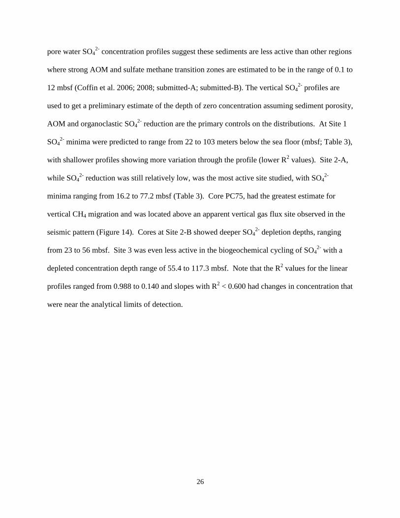
concentration profiles suggest these sediments are less active than other regions
where strong AOM and sulfate methane transition zones are estimated to be in the range of 0.1 to
12 mbsf (Coffin et al. 2006; 2008; submitted-A; submitted-B). The vertical SO42-
profiles are
used to get a preliminary estimate of the depth of zero concentration assuming sediment porosity,
AOM and organoclastic SO42-
reduction are the primary controls on the distributions. At Site 1
SO42-
minima were predicted to range from 22 to 103 meters below the sea floor (mbsf; Table 3),
with shallower profiles showing more variation through the profile (lower R2 values). Site 2-A,
while SO42-
reduction was still relatively low, was the most active site studied, with SO42-
minima ranging from 16.2 to 77.2 mbsf (Table 3). Core PC75, had the greatest estimate for
vertical CH4 migration and was located above an apparent vertical gas flux site observed in the
seismic pattern (Figure 14). Cores at Site 2-B showed deeper SO42-
depletion depths, ranging
from 23 to 56 mbsf. Site 3 was even less active in the biogeochemical cycling of SO42-
with a
depleted concentration depth range of 55.4 to 117.3 mbsf. Note that the R2 values for the linear
profiles ranged from 0.988 to 0.140 and slopes with R2 < 0.600 had changes in concentration that
were near the analytical limits of detection.
27
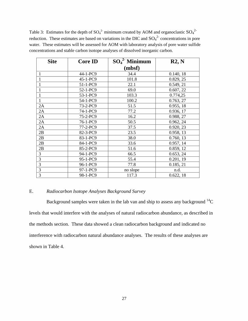
Table 3: Estimates for the depth of SO42-
minimum created by AOM and organoclastic SO42-
reduction. These estimates are based on variations in the DIC and SO42-
concentrations in pore
water. These estimates will be assessed for AOM with laboratory analysis of pore water sulfide
concentrations and stable carbon isotope analyses of dissolved inorganic carbon.
Site Core ID SO42-
Minimum
(mbsf)
R2, N
1 44-1-PC9 34.4 0.140, 18
1 45-1-PC9 101.8 0.829, 25
1 51-1-PC9 22.1 0.549, 21
1 52-1-PC9 69.0 0.607, 22
1 53-1-PC9 103.3 0.774,25
1 54-1-PC9 100.2 0.763, 27
2A 73-2-PC9 51.5 0.955, 18
2A 74-1-PC9 77.2 0.936, 17
2A 75-2-PC9 16.2 0.988, 27
2A 76-1-PC9 50.5 0.962, 24
2A 77-2-PC9 37.5 0.920, 23
2B 82-3-PC9 23.5 0.958, 13
2B 83-1-PC9 38.0 0.760, 13
2B 84-1-PC9 33.6 0.957, 14
2B 85-2-PC9 51.6 0.859, 12
3 94-1-PC9 66.5 0.653, 24
3 95-1-PC9 55.4 0.201, 19
3 96-1-PC9 77.8 0.185, 21
3 97-1-PC9 no slope n.d.
3 98-1-PC9 117.3 0.622, 18
E. Radiocarbon Isotope Analyses Background Survey
Background samples were taken in the lab van and ship to assess any background 14
C
levels that would interfere with the analyses of natural radiocarbon abundance, as described in
the methods section. These data showed a clean radiocarbon background and indicated no
interference with radiocarbon natural abundance analyses. The results of these analyses are
shown in Table 4.
28
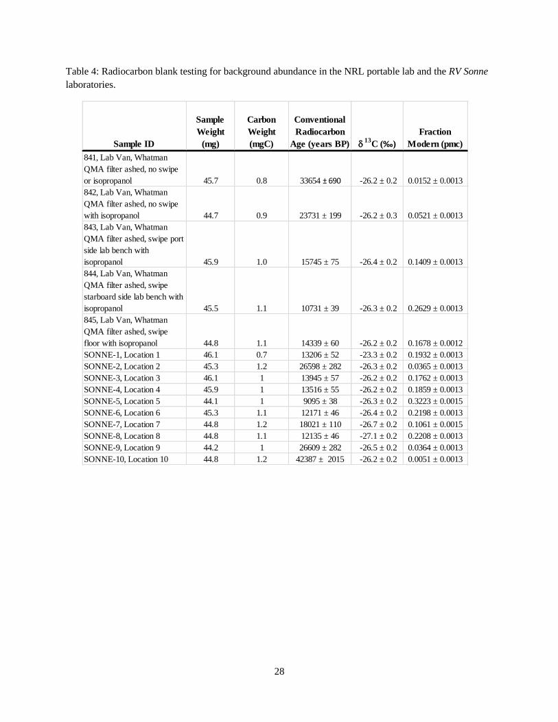
Table 4: Radiocarbon blank testing for background abundance in the NRL portable lab and the RV Sonne
laboratories.
Sample ID
Sample
Weight
(mg)
Carbon
Weight
(mgC)
Conventional
Radiocarbon
Age (years BP) 13
C (‰)
Fraction
Modern (pmc)
841, Lab Van, Whatman
QMA filter ashed, no swipe
or isopropanol 45.7 0.8 33654 ± 690 -26.2 ± 0.2 0.0152 ± 0.0013
842, Lab Van, Whatman
QMA filter ashed, no swipe
with isopropanol 44.7 0.9 23731 ± 199 -26.2 ± 0.3 0.0521 ± 0.0013
843, Lab Van, Whatman
QMA filter ashed, swipe port
side lab bench with
isopropanol 45.9 1.0 15745 ± 75 -26.4 ± 0.2 0.1409 ± 0.0013
844, Lab Van, Whatman
QMA filter ashed, swipe
starboard side lab bench with
isopropanol 45.5 1.1 10731 ± 39 -26.3 ± 0.2 0.2629 ± 0.0013
845, Lab Van, Whatman
QMA filter ashed, swipe
floor with isopropanol 44.8 1.1 14339 ± 60 -26.2 ± 0.2 0.1678 ± 0.0012
SONNE-1, Location 1 46.1 0.7 13206 ± 52 -23.3 ± 0.2 0.1932 ± 0.0013
SONNE-2, Location 2 45.3 1.2 26598 ± 282 -26.3 ± 0.2 0.0365 ± 0.0013
SONNE-3, Location 3 46.1 1 13945 ± 57 -26.2 ± 0.2 0.1762 ± 0.0013
SONNE-4, Location 4 45.9 1 13516 ± 55 -26.2 ± 0.2 0.1859 ± 0.0013
SONNE-5, Location 5 44.1 1 9095 ± 38 -26.3 ± 0.2 0.3223 ± 0.0015
SONNE-6, Location 6 45.3 1.1 12171 ± 46 -26.4 ± 0.2 0.2198 ± 0.0013
SONNE-7, Location 7 44.8 1.2 18021 ± 110 -26.7 ± 0.2 0.1061 ± 0.0015
SONNE-8, Location 8 44.8 1.1 12135 ± 46 -27.1 ± 0.2 0.2208 ± 0.0013
SONNE-9, Location 9 44.2 1 26609 ± 282 -26.5 ± 0.2 0.0364 ± 0.0013
SONNE-10, Location 10 44.8 1.2 42387 ± 2015 -26.2 ± 0.2 0.0051 ± 0.0013

29
VI. Summary
The preliminary data obtained during the SO226/2 expedition provides the following
information for completing the analysis of samples to evaluate paleogeochemical CH4 cycling
across Chatham Rise.
1. Low current day CH4 vertical fluxes suggest there will not be an overlap of the modern
day and paleogeochemical carbon cycling.
2. A large variation in shallow sediment depths relative scoured regions will require careful
selection of cores sites and thorough age profiles in the mixed sediment.
3. Current day organic and inorganic carbon sources will be determined with analysis of
13
C of organic and inorganic sediment and pore water carbon.
4. Stable nitrogen isotope analysis of organic matter will be included in the evaluation to
understand the shallow sediment carbon cycling.
5. Radioisotopes (230
Th, 210
Pb, and 231
Pa) will be examined through the coring regions to
determine the modern day sedimentation rates and spatial variation of sediment mixing
and redistribution.
6. 14
C of sediment inorganic and organic carbon to determine if CH4 contributed to
shallow sediment carbon cycle during previous climate change events.
30
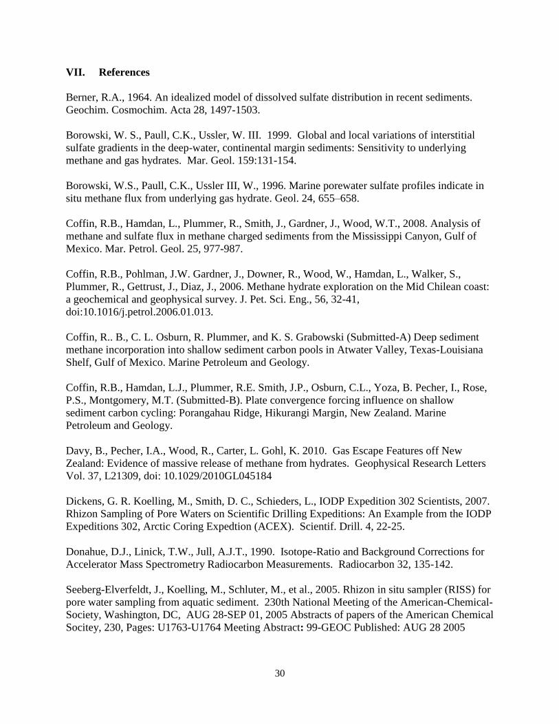
VII. References
Berner, R.A., 1964. An idealized model of dissolved sulfate distribution in recent sediments.
Geochim. Cosmochim. Acta 28, 1497-1503.
Borowski, W. S., Paull, C.K., Ussler, W. III. 1999. Global and local variations of interstitial
sulfate gradients in the deep-water, continental margin sediments: Sensitivity to underlying
methane and gas hydrates. Mar. Geol. 159:131-154.
Borowski, W.S., Paull, C.K., Ussler III, W., 1996. Marine porewater sulfate profiles indicate in
situ methane flux from underlying gas hydrate. Geol. 24, 655–658.
Coffin, R.B., Hamdan, L., Plummer, R., Smith, J., Gardner, J., Wood, W.T., 2008. Analysis of
methane and sulfate flux in methane charged sediments from the Mississippi Canyon, Gulf of
Mexico. Mar. Petrol. Geol. 25, 977-987.
Coffin, R.B., Pohlman, J.W. Gardner, J., Downer, R., Wood, W., Hamdan, L., Walker, S.,
Plummer, R., Gettrust, J., Diaz, J., 2006. Methane hydrate exploration on the Mid Chilean coast:
a geochemical and geophysical survey. J. Pet. Sci. Eng., 56, 32-41,
doi:10.1016/j.petrol.2006.01.013.
Coffin, R.. B., C. L. Osburn, R. Plummer, and K. S. Grabowski (Submitted-A) Deep sediment
methane incorporation into shallow sediment carbon pools in Atwater Valley, Texas-Louisiana
Shelf, Gulf of Mexico. Marine Petroleum and Geology.
Coffin, R.B., Hamdan, L.J., Plummer, R.E. Smith, J.P., Osburn, C.L., Yoza, B. Pecher, I., Rose,
P.S., Montgomery, M.T. (Submitted-B). Plate convergence forcing influence on shallow
sediment carbon cycling: Porangahau Ridge, Hikurangi Margin, New Zealand. Marine
Petroleum and Geology.
Davy, B., Pecher, I.A., Wood, R., Carter, L. Gohl, K. 2010. Gas Escape Features off New
Zealand: Evidence of massive release of methane from hydrates. Geophysical Research Letters
Vol. 37, L21309, doi: 10.1029/2010GL045184
Dickens, G. R. Koelling, M., Smith, D. C., Schieders, L., IODP Expedition 302 Scientists, 2007.
Rhizon Sampling of Pore Waters on Scientific Drilling Expeditions: An Example from the IODP
Expeditions 302, Arctic Coring Expedtion (ACEX). Scientif. Drill. 4, 22-25.
Donahue, D.J., Linick, T.W., Jull, A.J.T., 1990. Isotope-Ratio and Background Corrections for
Accelerator Mass Spectrometry Radiocarbon Measurements. Radiocarbon 32, 135-142.
Seeberg-Elverfeldt, J., Koelling, M., Schluter, M., et al., 2005. Rhizon in situ sampler (RISS) for
pore water sampling from aquatic sediment. 230th National Meeting of the American-Chemical-
Society, Washington, DC, AUG 28-SEP 01, 2005 Abstracts of papers of the American Chemical
Socitey, 230, Pages: U1763-U1764 Meeting Abstract: 99-GEOC Published: AUG 28 2005

31
Stuiver, M., 1983. International Agreements and the Use of the New Oxalic Acid Standard.
Radiocarbon. 25, 793-795.

32
Appendix 1: Weekly Reports
SO226-1 Week 1
33

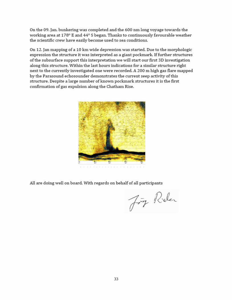
34
S0226-1 Week 2-
35
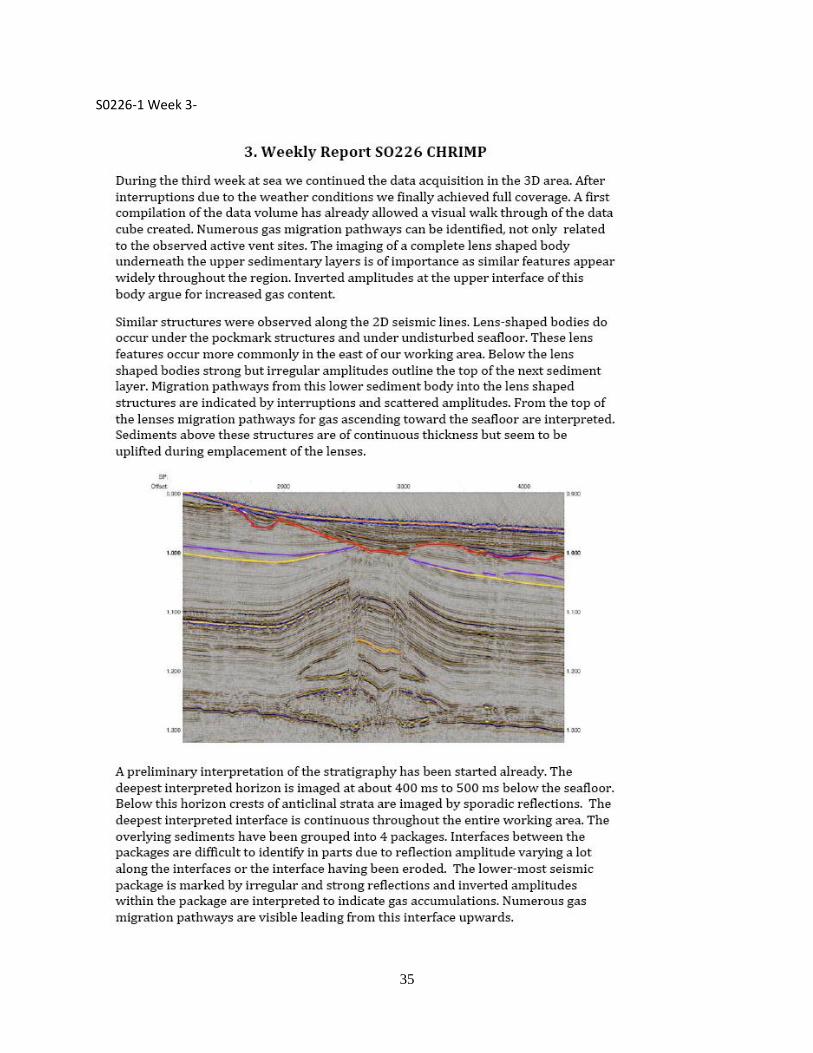
S0226-1 Week 3-

36
37
S0226-1 Week 4-
38
39
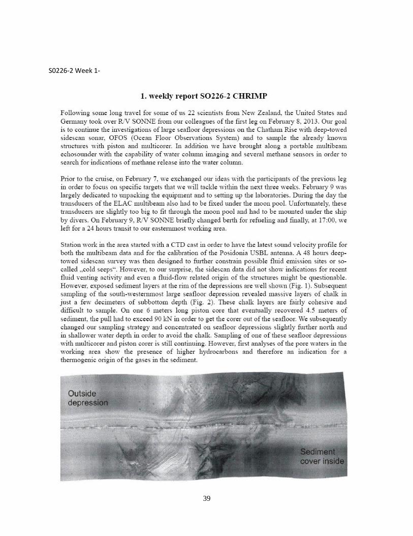
S0226-2 Week 1-
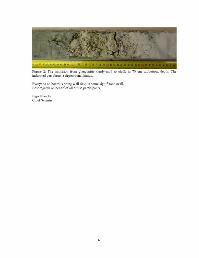
40

41
S0226-2 Week 2
-
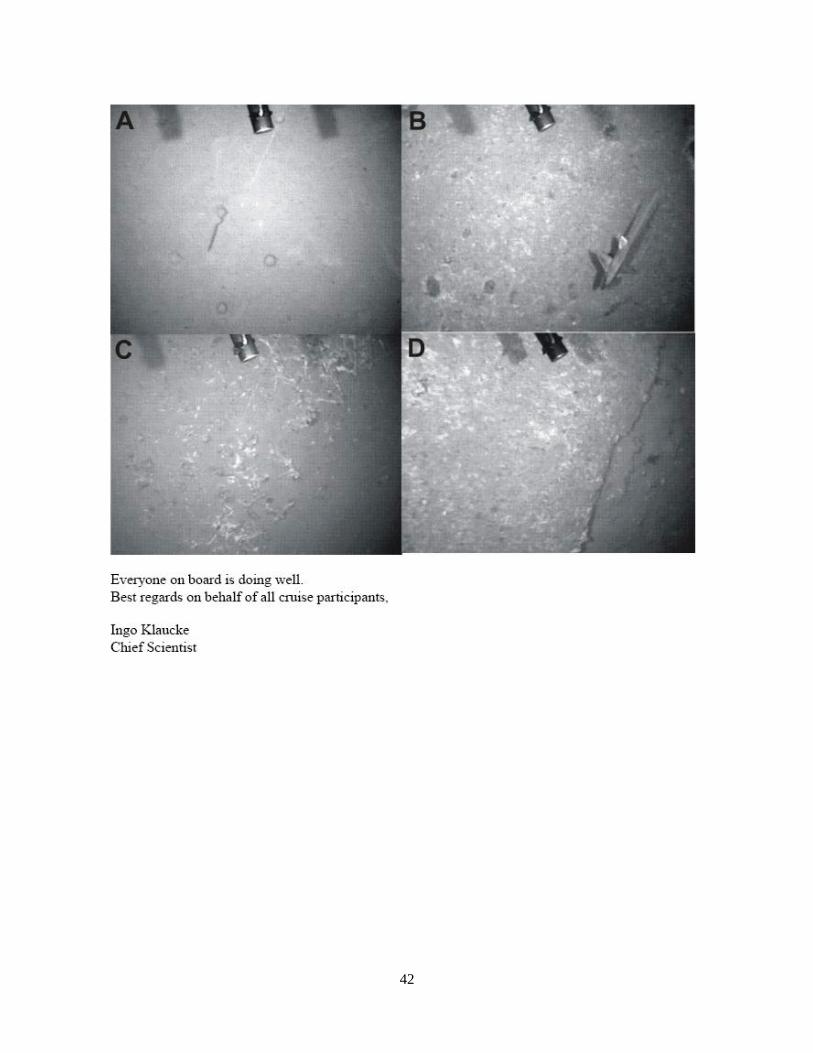
42

43
S0226-2 Week 3
44

45
Appendix 2: Key daily operations for SO226/2 are listed in the following text. Log of this
activity follows the brief description.
February 7, 2013
Initial laboratory and deck operations organization
Receipt of final operation gear
Meeting to discuss field planning. Discussions included review of the seismic data at
Site 1-3. Participants included. Ingo Pecher, Ingo Klaucke, Rick Coffin, Paula Rose
February 8, 2013
Installation and testing of laboratory instruments
Review of lab, core processing and deck equipment
February 9, 2013
15:00 departure for first station
Ship safety review
Lab instrument calibration
Ship science meeting on field plan
NRL meeting on laboratory and deck operations
February 10, 2013
Transit to Site 1
Lab instrument calibrations were conducted on the GC, IC and calorimeter
CTD testing was conducted.
SIMRAD Multibeam / Parasound operations were run
February 11, 2013
Multibeam calibration was conducted
Initial “test” piston core was taken in a seismic non-active region
February 12, 2013
Multi-beam run through Site 1 for 24 hours.
Sediment gases, DIC, and sulfate were analyzed from the test core
February 13, 2013
Piston coring was started across Site 1, running westward to the east
46
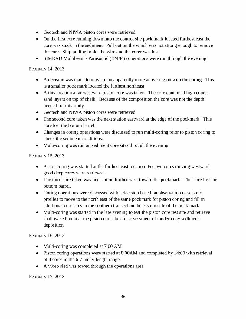
Geotech and NIWA piston cores were retrieved
On the first core running down into the control site pock mark located furthest east the
core was stuck in the sediment. Pull out on the winch was not strong enough to remove
the core. Ship pulling broke the wire and the corer was lost.
SIMRAD Multibeam / Parasound (EM/PS) operations were run through the evening
February 14, 2013
A decision was made to move to an apparently more active region with the coring. This
is a smaller pock mark located the furthest northeast.
A this location a far westward piston core was taken. The core contained high course
sand layers on top of chalk. Because of the composition the core was not the depth
needed for this study.
Geotech and NIWA piston cores were retrieved
The second core taken was the next station eastward at the edge of the pockmark. This
core lost the bottom barrel.
Changes in coring operations were discussed to run multi-coring prior to piston coring to
check the sediment conditions.
Multi-coring was run on sediment core sites through the evening.
February 15, 2013
Piston coring was started at the furthest east location. For two cores moving westward
good deep cores were retrieved.
The third core taken was one station further west toward the pockmark. This core lost the
bottom barrel.
Coring operations were discussed with a decision based on observation of seismic
profiles to move to the north east of the same pockmark for piston coring and fill in
additional core sites in the southern transect on the eastern side of the pock mark.
Multi-coring was started in the late evening to test the piston core test site and retrieve
shallow sediment at the piston core sites for assessment of modern day sediment
deposition.
February 16, 2013
Multi-coring was completed at 7:00 AM
Piston coring operations were started at 8:00AM and completed by 14:00 with retrieval
of 4 cores in the 6-7 meter length range.
A video sled was towed through the operations area.
February 17, 2013

47
Milbar lead coring operations for U. Otago. Four cores were taken for ground truthing of
seismic data profiling. These core were taken with the piston core turned into a 3 m
gravity core. The region was no active sediment.
NIWA lead multi core. NRL (P. Rose) obtained two cores to calibrate shallow sediment
age data analysis. Cores were the first core at the piston core test site and the furthest
west piston core at Site 1.
Transit to the second coring location was started, this was a 13 hour distance.
February 18, 2013
Water column CTD profiles were conducted
Multibeam side scan was initiated in the new study region with a plan to run scans for 48
hours
A group discussion evolved on the next coring sites, Site 2.
February 19, 2013
Multibean side scan was continued.
Core barrels were fixed and the piston core set up for further operations.
Porewater sulfate and chloride sample analysis from the first location was completed.
February 20, 2013
Multibean side scan was continued.
Multicoring was conducted at Site 2-A
Piston coring was initiated on Site 2-A
February 21, 2013
Piston coring was continued on Site 2-A.
Multicoring was initiated on Site 2-B.
February 22, 2013
Piston coring was continued on Site 2-B.
Surveying with the EM/PS was continued
February 23, 2013
Towed array for ocean floor observation
Surveying with the EM/PS was continued
February 24, 2013
Side scan was run.

48
February 25, 2013
Multicorer was run on site 3
Piston coring was conducted on site 3
February 26, 2013
Through this final run all but one of the core barrels were bent or lost, piston coring was
terminated.
Multicoring was completed at this last site.
February 27, 2013
Final EM/PS surveying
Transit to Wellington
February 28, 2013
Packing instrumentation
Complete IC analysis before packing this instrument
Transit to Wellington
March 1, 2013
08:00 docking in Wellington New Zealand.
Ship offloading operations began.
All shipping was organized and secured.
All personnel were off loaded and began travel home.
49
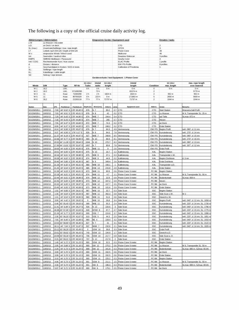
The following is a copy of the official cruise daily activity log.
Abkürzungen / Abbreviation Eingesetzte Geräte / Equiopment used Einsätze / tasks
z.W zu Wasser / into water
o.D. an Deck / on deck CTD 2
SL (max.) (maximale)Seillänge / max. rope-length OFOS 3
LT Lottiefe nach EM 120 / Depth of EM 120 Piston Corer 39
W x eingesetzte Winde / Winch used Multicorer 46
nm Seemeilen / nautical miles Deeptow-Sidescan 3 profiles
EM/PS SIMRAD Multibeam / Parasound Gravity Corer 4
rwk / COG: Rechtweisender Kurs / true course ELAC-Profile 1 profile
d: Distanz / distance EM / PS-Profile 8 profiles
v: Geschwindigkeit in Knoten / SOG in knots Calibration of Posidonia 1
SL: Seillänge / rope-length
KL: Kabellänge / cable-length
SZ: Seilzug / rope tension
Geräteverluste / lost Equipment: 1 Piston Corer
SO 226-2 intotal SO 226-2 intotal SO 226-2 max. rope length
Winde D/M Type RF-Nr Tasks tasks length length Condition max. length ever lowered
W 1 18,2 LWL 0 h 0 h 0 m 0 m 0 0 m 0 m
W 2 18.2 LWL 071000295 73 h 81574 m 2 5770 m
W 4 11 Koax 71000299 2 h 2 h 1824 m 1824 m 2 952 m 952 m
W 5 11 Koax 80700329 0 h 223 h 0 m 171863 m 5 2650 m 5600 m
W 6 18,2 Koax 21200118 77 h 77 h 71737 m 71737 m 2 1044 m 1044 m
Station Date UTC PositionLat PositionLon Depth [m] Wind [m/s] COG [°] v [kn] Equipment used Abbrev. Action Remarks
SO226/028-1 10/02/13 7:00 44° 6,52' S 178° 45,00' E 876 N 7 90.2 0.7 CTD CTD Start Station Wasserschall-Profil
SO226/028-1 10/02/13 7:03 44° 6,51' S 178° 45,01' E 876 N 8 42 0.2 CTD CTD zu Wasser W 4; Transponder SL: 25 m
SO226/028-1 10/02/13 7:29 44° 6,43' S 178° 44,90' E 874 NNE 7 244.4 0.4 CTD CTD auf Tiefe SLmax: 872 m
SO226/028-1 10/02/13 7:30 44° 6,43' S 178° 44,90' E 874 NNE 7 265 0.7 CTD CTD Hieven
SO226/028-1 10/02/13 7:55 44° 6,37' S 178° 44,84' E 872 NNE 7 74.3 0.2 CTD CTD an Deck
SO226/028-1 10/02/13 8:00 44° 6,37' S 178° 44,83' E 873 NNE 7 248.2 0.2 CTD CTD Ende Station
SO226/029-1 10/02/13 8:14 44° 6,56' S 178° 45,07' E 876 N 7 94.3 4.9 Vermessung EM / PS Beginn Profil rwK: 090°; d: 11 nm
SO226/029-1 10/02/13 9:37 44° 6,56' S 179° 0,17' E 826 N 6 94.6 7.8 Vermessung EM / PS Kursänderung rwK: 270°; d: 14 nm
SO226/029-1 10/02/13 11:37 44° 8,19' S 178° 40,97' E 927 NNE 7 268.8 8.5 Vermessung EM / PS Kursänderung rwK: 090°; d: 15 nm
SO226/029-1 10/02/13 13:36 44° 9,77' S 178° 59,99' E 900 N 10 96.9 8.1 Vermessung EM / PS Kursänderung rwK: 270°; d: 16 nm
SO226/029-1 10/02/13 15:52 44° 11,39' S 178° 39,64' E 1044 N 10 270.7 8.3 Vermessung EM / PS Kursänderung rwK: 090°; d: 13 nm
SO226/029-1 10/02/13 17:30 44° 13,01' S 178° 52,87' E 1007 N 7 90.8 7.8 Vermessung EM / PS Kursänderung rwK: 307°; d: 12 nm
SO226/029-1 10/02/13 19:00 44° 6,05' S 178° 40,00' E 876 NNE 11 9 2.6 Vermessung EM / PS Ende Profil
SO226/030-1 10/02/13 19:01 44° 6,05' S 178° 40,00' E 875 N 10 16.7 1.2 Kalibrierung KAL Beginn Station
SO226/030-1 10/02/13 19:16 44° 6,01' S 178° 39,98' E 875 NNE 9 37.1 0.3 Kalibrierung KAL Transponder z.W.
SO226/030-1 10/02/13 19:28 44° 6,02' S 178° 39,99' E 874 NNE 9 44.9 0.2 Kalibrierung KAL Beginn Drehkreis d: 3 nm
SO226/030-1 10/02/13 20:40 44° 5,85' S 178° 40,35' E 867 N 9 349.4 2.6 Kalibrierung KAL Ende Drehkreis
SO226/030-1 10/02/13 21:19 44° 6,32' S 178° 40,31' E 880 NNE 10 166.1 1 Kalibrierung KAL Transponder a.D.
SO226/030-1 10/02/13 21:25 44° 6,54' S 178° 40,43' E 885 ENE 13 215.8 2.9 Kalibrierung KAL Ende Station
SO226/031-1 10/02/13 21:59 44° 6,03' S 178° 40,01' E 873 NNE 11 90.9 0.6 Piston Corer 9 meter PC 9M Beginn Station
SO226/031-1 10/02/13 22:18 44° 6,01' S 178° 40,01' E 874 NNE 11 4.7 1.1 Piston Corer 9 meter PC 9M zu Wasser W 6; Transponder SL: 50 m
SO226/031-1 10/02/13 22:44 44° 6,01' S 178° 39,99' E 874 NNE 12 22.9 0.9 Piston Corer 9 meter PC 9M Bodenkontakt SLmax: 859 m
SO226/031-1 10/02/13 22:45 44° 6,00' S 178° 39,99' E 873 NNE 12 347.2 0.9 Piston Corer 9 meter PC 9M hieven
SO226/031-1 10/02/13 23:32 44° 6,00' S 178° 39,97' E 873 NNE 12 157.7 0.5 Piston Corer 9 meter PC 9M an Deck
SO226/031-1 10/02/13 23:45 44° 6,05' S 178° 40,08' E 873 NNE 10 101.6 0.9 Piston Corer 9 meter PC 9M Ende Station
SO226/032-1 11/02/13 1:02 44° 6,66' S 178° 26,51' E 967 NNE 10 32.7 0.3 Side Scan SSC Beginn Station
SO226/032-1 11/02/13 1:30 44° 6,64' S 178° 26,53' E 967 NNE 11 352.4 0.8 Side Scan SSC Side Scan z.W. W 2
SO226/032-1 11/02/13 1:41 44° 6,54' S 178° 26,55' E 960 NNE 11 51.6 0.6 Side Scan SSC Gewicht z.W.
SO226/032-1 11/02/13 3:00 44° 4,42' S 178° 29,02' E 0 NNE 10 26.8 3.4 Side Scan SSC Beginn Profil rwK: 040°; d: 12 nm; SL: 1658 m
SO226/032-1 11/02/13 6:48 43° 55,43' S 178° 39,63' E 589 NNE 11 55.3 2.4 Side Scan SSC Kursänderung rwK: 220°; d: 14 nm; SL: 1730 m
SO226/032-1 11/02/13 11:41 44° 6,49' S 178° 29,27' E 926 N 13 220.5 3 Side Scan SSC Kursänderung rwK: 040°; d: 14 nm; SL: 1796 m
SO226/032-1 11/02/13 16:38 43° 57,30' S 178° 42,63' E 640 WSW 8 67.7 2.7 Side Scan SSC Kursänderung rwK: 220°; d: 15 nm; SL: 1775 m
SO226/032-1 11/02/13 21:34 44° 5,77' S 178° 28,83' E 909 SSE 7 224.8 3.7 Side Scan SSC Kursänderung rwK: 040°; d: 15 nm; SL: 1998 m
SO226/032-1 12/02/13 2:30 43° 56,20' S 178° 42,67' E 610 SSE 5 44.3 2.5 Side Scan SSC Kursänderung rwK: 220°; d: 16 nm; SL: 1851 m
SO226/032-1 12/02/13 7:55 44° 8,40' S 178° 32,08' E 960 NE 4 228.4 3.2 Side Scan SSC Kursänderung rwK: 040°; d: 15 nm; SL: 1910 m
SO226/032-1 12/02/13 13:02 43° 58,60' S 178° 46,46' E 827 N 7 31 3.1 Side Scan SSC Kursänderung rwK: 220°; d: 16 nm; SL: 2122 m
SO226/032-1 12/02/13 18:11 44° 7,64' S 178° 31,87' E 937 NNW 7 232.6 2.1 Side Scan SSC Kursänderung rwK: 040°; d: 14 nm; SL: 1826 m
SO226/032-1 12/02/13 23:12 43° 58,29' S 178° 45,49' E 0 SSW 10 36.8 3.3 Side Scan SSC Ende Profil
SO226/032-1 12/02/13 23:51 43° 59,02' S 178° 46,43' E 740 SSW 13 194.9 1.7 Side Scan SSC Gewicht a.D.
SO226/032-1 12/02/13 23:59 43° 59,18' S 178° 46,44' E 706 SSW 14 217.7 0.9 Side Scan SSC Side Scan a. D.
SO226/032-1 13/02/13 0:15 43° 59,21' S 178° 46,54' E 707 S 12 217.9 2 Side Scan SSC Ende Station
SO226/033-1 13/02/13 1:49 44° 5,72' S 178° 31,23' E 900 SSW 10 52.5 0.3 Piston Corer 9 meter PC 9M Beginn Station
SO226/033-1 13/02/13 2:05 44° 5,68' S 178° 31,18' E 900 SW 12 275.2 0.6 Piston Corer 9 meter PC 9M zu Wasser W 6, Transponder SL: 50 m
SO226/033-1 13/02/13 2:29 44° 5,73' S 178° 31,24' E 899 SW 12 341.8 0.3 Piston Corer 9 meter PC 9M Bodenkontakt SLmax: 885 m; SZmax: 65 kN
SO226/033-1 13/02/13 3:09 44° 5,70' S 178° 31,13' E 900 SSW 11 332.5 0.6 Piston Corer 9 meter PC 9M an Deck
SO226/033-1 13/02/13 3:09 44° 5,70' S 178° 31,13' E 900 SSW 11 332.5 0.6 Piston Corer 9 meter PC 9M Ende Station
SO226/033-2 13/02/13 3:10 44° 5,70' S 178° 31,13' E 900 SSW 11 225.2 0.3 Piston Corer 6 meter PC 6M Beginn Station
SO226/033-2 13/02/13 4:06 44° 5,73' S 178° 31,23' E 901 SSW 8 211.1 1.5 Piston Corer 6 meter PC 6M zu Wasser W 6; Transponder SL: 50 m
SO226/033-2 13/02/13 4:30 44° 5,74' S 178° 31,22' E 901 SW 8 186.3 0.3 Piston Corer 6 meter PC 6M Bodenkontakt SLmax: 889 m; SZmax: 89 kN
SO226/033-2 13/02/13 5:07 44° 5,71' S 178° 31,26' E 900 SW 6 179.1 0.5 Piston Corer 6 meter PC 6M an Deck
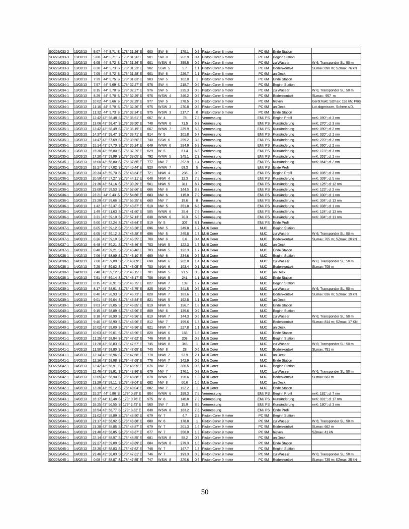
50
SO226/033-2 13/02/13 5:07 44° 5,71' S 178° 31,26' E 900 SW 6 179.1 0.5 Piston Corer 6 meter PC 6M Ende Station
SO226/033-3 13/02/13 5:08 44° 5,71' S 178° 31,26' E 901 SW 8 262.9 0.4 Piston Corer 6 meter PC 6M Beginn Station
SO226/033-3 13/02/13 6:05 44° 5,72' S 178° 31,26' E 901 WSW 6 355.5 0.9 Piston Corer 6 meter PC 6M zu Wasser W 6; Transponder SL: 50 m
SO226/033-3 13/02/13 6:30 44° 5,73' S 178° 31,23' E 902 SSW 5 5.7 1.1 Piston Corer 6 meter PC 6M Bodenkontakt SLmax: 890 m; SZmax: 76 kN
SO226/033-3 13/02/13 7:05 44° 5,72' S 178° 31,28' E 901 SW 6 226.7 1.1 Piston Corer 6 meter PC 6M an Deck
SO226/033-3 13/02/13 7:39 44° 5,75' S 178° 31,63' E 903 SW 5 102.8 1 Piston Corer 6 meter PC 6M Ende Station
SO226/034-1 13/02/13 7:57 44° 5,69' S 178° 32,27' E 976 SW 4 218.7 0.6 Piston Corer 6 meter PC 6M Beginn Station
SO226/034-1 13/02/13 8:15 44° 5,70' S 178° 32,27' E 976 SW 5 235.3 0.5 Piston Corer 6 meter PC 6M zu Wasser W 6; Transponder SL: 50 m
SO226/034-1 13/02/13 8:29 44° 5,70' S 178° 32,29' E 976 WSW 4 346.2 0.6 Piston Corer 6 meter PC 6M Bodenkontakt SLmax: 957 m
SO226/034-1 13/02/13 10:02 44° 5,66' S 178° 32,29' E 977 SW 5 278.5 0.6 Piston Corer 6 meter PC 6M hieven Gerät hakt; SZmax: 152 kN; Plötzliche Entlastung
SO226/034-1 13/02/13 11:10 44° 5,70' S 178° 32,26' E 975 WSW 3 270.8 0.8 Piston Corer 6 meter PC 6M an Deck Lot abgerissen, Schere a.D.
SO226/034-1 13/02/13 11:32 44° 5,73' S 178° 32,34' E 975 WSW 3 217.7 0 Piston Corer 6 meter PC 6M Ende Station
SO226/035-1 13/02/13 12:42 43° 58,48' S 178° 35,61' E 667 W 4 78 7.8 Vermessung EM / PS Beginn Profil rwK: 090°; d: 3 nm
SO226/035-1 13/02/13 13:06 43° 58,47' S 178° 39,50' E 748 WNW 6 71.5 6.3 Vermessung EM / PS Kursänderung rwK: 270°; d: 3 nm
SO226/035-1 13/02/13 13:42 43° 58,49' S 178° 35,19' E 667 WNW 7 239.9 5.3 Vermessung EM / PS Kursänderung rwK: 090°; d: 2 nm
SO226/035-1 13/02/13 14:37 43° 58,47' S 178° 38,71' E 814 W 5 101.8 5.7 Vermessung EM / PS Kursänderung rwK: 020°; d: 1 nm
SO226/035-1 13/02/13 14:47 43° 57,69' S 178° 39,50' E 740 SSW 6 259.2 3.8 Vermessung EM / PS Kursänderung rwK: 270°; d: 2 nm
SO226/035-1 13/02/13 15:14 43° 57,70' S 178° 35,24' E 649 WNW 6 284.9 6.9 Vermessung EM / PS Kursänderung rwK: 060°; d: 2 nm
SO226/035-1 13/02/13 15:30 43° 56,80' S 178° 37,29' E 629 W 5 61.4 6.8 Vermessung EM / PS Kursänderung rwK: 173°; d: 3 nm
SO226/035-1 13/02/13 17:20 43° 59,99' S 178° 38,05' E 792 WNW 5 245.1 2.2 Vermessung EM / PS Kursänderung rwK: 353°; d: 1 nm
SO226/035-1 13/02/13 18:00 43° 58,80' S 178° 37,85' E 777 NW 7 292.9 1.4 Vermessung EM / PS Kursänderung rwK: 064°; d: 2 nm
SO226/035-1 13/02/13 18:27 43° 57,82' S 178° 40,44' E 820 WNW 7 69.3 5 Vermessung EM / PS Ende Profil
SO226/036-1 13/02/13 20:34 43° 59,70' S 178° 43,84' E 721 NNW 4 238 0.9 Vermessung EM / PS Beginn Profil rwK: 005°; d: 3 nm
SO226/036-1 13/02/13 20:59 43° 57,27' S 178° 44,11' E 648 NNW 4 12.3 7.8 Vermessung EM / PS Kursänderung rwK: 309°; d: 5 nm
SO226/036-1 13/02/13 21:36 43° 54,16' S 178° 39,29' E 561 NNW 5 311 8.7 Vermessung EM / PS Kursänderung rwK: 125°; d: 12 nm
SO226/036-1 13/02/13 23:08 43° 59,53' S 178° 52,66' E 666 NW 6 144.5 8.2 Vermessung EM / PS Kursänderung rwK: 123°; d: 2 nm
SO226/036-1 13/02/13 23:21 44° 0,43' S 178° 54,66' E 683 NW 6 115.9 7.9 Vermessung EM / PS Kursänderung rwK: 030°; d: 1 nm
SO226/036-1 13/02/13 23:29 43° 59,66' S 178° 55,35' E 660 NW 7 19.6 8 Vermessung EM / PS Kursänderung rwK: 304°; d: 13 nm
SO226/036-1 14/02/13 1:42 43° 52,37' S 178° 40,87' E 519 NW 5 351.8 6.8 Vermessung EM / PS Kursänderung rwK: 038°; d: 1 nm
SO226/036-1 14/02/13 1:49 43° 51,63' S 178° 41,60' E 505 WNW 6 35.4 7.6 Vermessung EM / PS Kursänderung rwK: 124°; d: 13 nm
SO226/036-1 14/02/13 3:31 43° 59,10' S 178° 57,13' E 638 WNW 6 70.3 5.3 Vermessung EM / PS Kursänderung rwK: 304°; d: 11 nm
SO226/036-1 14/02/13 5:00 43° 52,24' S 178° 45,64' E 519 W 5 307 8.1 Vermessung EM / PS Ende Profil
SO226/037-1 14/02/13 6:05 43° 59,12' S 178° 45,38' E 696 NW 5 349.8 1.7 Multi Corer MUC Beginn Station
SO226/037-1 14/02/13 6:05 43° 59,12' S 178° 45,38' E 696 NW 5 349.8 1.7 Multi Corer MUC zu Wasser W 6; Transponder SL: 50 m
SO226/037-1 14/02/13 6:26 43° 59,10' S 178° 45,35' E 700 NW 6 6.6 0.4 Multi Corer MUC Bodenkontakt SLmax: 705 m; SZmax: 20 kN
SO226/037-1 14/02/13 6:48 43° 59,21' S 178° 45,46' E 703 NNW 5 122.3 1.7 Multi Corer MUC an Deck
SO226/037-1 14/02/13 6:48 43° 59,21' S 178° 45,46' E 703 NNW 5 122.3 1.7 Multi Corer MUC Ende Station
SO226/038-1 14/02/13 7:06 43° 58,99' S 178° 46,10' E 699 NW 6 334.6 0.7 Multi Corer MUC Beginn Station
SO226/038-1 14/02/13 7:08 43° 59,00' S 178° 46,09' E 698 NNW 6 282.8 1.4 Multi Corer MUC zu Wasser W 6; Transponder SL: 50 m
SO226/038-1 14/02/13 7:29 43° 59,02' S 178° 46,05' E 700 NNW 6 193.4 0.1 Multi Corer MUC Bodenkontakt SLmax: 708 m
SO226/038-1 14/02/13 7:48 43° 59,12' S 178° 46,15' E 701 NNW 5 91.5 0.5 Multi Corer MUC an Deck
SO226/038-1 14/02/13 7:51 43° 59,14' S 178° 46,17' E 706 NNW 5 241 1.1 Multi Corer MUC Ende Station
SO226/039-1 14/02/13 8:15 43° 58,91' S 178° 46,75' E 827 NNW 7 139 1.7 Multi Corer MUC Beginn Station
SO226/039-1 14/02/13 8:17 43° 58,91' S 178° 46,75' E 825 NNW 7 341.5 0.6 Multi Corer MUC zu Wasser W 6; Transponder SL: 50 m
SO226/039-1 14/02/13 8:40 43° 58,93' S 178° 46,73' E 828 NNW 7 183.6 1.3 Multi Corer MUC Bodenkontakt SLmax: 836 m; SZmax: 19 kN
SO226/039-1 14/02/13 9:01 43° 59,04' S 178° 46,84' E 821 NNW 5 192.8 1.1 Multi Corer MUC an Deck
SO226/039-1 14/02/13 9:03 43° 59,05' S 178° 46,85' E 819 NNW 5 156.7 1.8 Multi Corer MUC Ende Station
SO226/040-1 14/02/13 9:15 43° 58,89' S 178° 46,96' E 809 NW 6 139.6 0.9 Multi Corer MUC Beginn Station
SO226/040-1 14/02/13 9:18 43° 58,90' S 178° 46,96' E 810 NNW 7 144.3 0.6 Multi Corer MUC zu Wasser W 6; Transponder SL: 50 m
SO226/040-1 14/02/13 9:40 43° 58,90' S 178° 46,96' E 812 NW 7 199.6 1.3 Multi Corer MUC Bodenkontakt SLmax: 814 m; SZmax: 17 KN
SO226/040-1 14/02/13 10:02 43° 59,00' S 178° 46,96' E 821 NNW 7 227.8 1.1 Multi Corer MUC an Deck
SO226/040-1 14/02/13 10:03 43° 59,01' S 178° 46,96' E 820 NNW 6 166 1.8 Multi Corer MUC Ende Station
SO226/041-1 14/02/13 11:25 43° 58,84' S 178° 47,62' E 746 NNW 8 208 0.8 Multi Corer MUC Beginn Station
SO226/041-1 14/02/13 11:28 43° 58,83' S 178° 47,57' E 745 NNW 8 345 1 Multi Corer MUC zu Wasser W 6; Transponder SL: 50 m
SO226/041-1 14/02/13 11:50 43° 58,80' S 178° 47,65' E 740 NW 8 28 0.6 Multi Corer MUC Bodenkontakt SLmax: 751 m
SO226/041-1 14/02/13 12:14 43° 58,96' S 178° 47,68' E 778 NNW 7 93.9 2.1 Multi Corer MUC an Deck
SO226/041-1 14/02/13 12:16 43° 58,98' S 178° 47,68' E 776 NNW 7 342.9 0.6 Multi Corer MUC Ende Station
SO226/042-1 14/02/13 12:42 43° 58,91' S 178° 48,99' E 676 NW 7 306.5 0.5 Multi Corer MUC Beginn Station
SO226/042-1 14/02/13 12:46 43° 58,91' S 178° 48,96' E 679 NW 7 176.1 0.8 Multi Corer MUC zu Wasser W 6; Transponder SL: 50 m
SO226/042-1 14/02/13 13:05 43° 58,90' S 178° 48,88' E 678 WNW 7 196.6 1.2 Multi Corer MUC Bodenkontakt SLmax: 683 m
SO226/042-1 14/02/13 13:29 43° 59,11' S 178° 49,04' E 682 NW 8 60.6 1.5 Multi Corer MUC an Deck
SO226/042-1 14/02/13 13:30 43° 59,12' S 178° 49,04' E 682 NW 7 192.2 1 Multi Corer MUC Ende Station
SO226/043-1 14/02/13 15:27 44° 5,86' S 179° 0,89' E 804 WNW 6 189.3 7.8 Vermessung EM / PS Beginn Profil rwK: 181°; d: 7 nm
SO226/043-1 14/02/13 16:17 44° 12,48' S 179° 0,76' E 975 W 8 146.8 7.2 Vermessung EM / PS Kursänderung rwK: 001°; d: 17 nm
SO226/043-1 14/02/13 18:25 43° 56,55' S 179° 2,43' E 560 SW 7 15.9 8.5 Vermessung EM / PS Kursänderung rwK: 180°; d: 3 nm
SO226/043-1 14/02/13 18:54 43° 58,77' S 179° 3,82' E 638 WSW 8 183.2 7.8 Vermessung EM / PS Ende Profil
SO226/044-1 14/02/13 21:02 43° 58,89' S 178° 48,90' E 679 W 7 4.7 2.2 Piston Corer 9 meter PC 9M Beginn Station
SO226/044-1 14/02/13 21:17 43° 58,92' S 178° 48,88' E 680 W 6 178.8 1 Piston Corer 9 meter PC 9M zu Wasser W 6; Transponder SL: 50 m
SO226/044-1 14/02/13 21:38 43° 58,85' S 178° 48,87' E 679 W 7 201.3 1.4 Piston Corer 9 meter PC 9M Bodenkontakt SLmax: 662 m
SO226/044-1 14/02/13 21:40 43° 58,85' S 178° 48,87' E 677 W 7 356.9 1.3 Piston Corer 9 meter PC 9M hieven SZmax: 41 kN
SO226/044-1 14/02/13 22:14 43° 58,97' S 178° 48,85' E 681 WSW 8 58.2 0.7 Piston Corer 9 meter PC 9M an Deck
SO226/044-1 14/02/13 22:27 43° 59,00' S 178° 48,89' E 684 WSW 8 279.3 1.6 Piston Corer 9 meter PC 9M Ende Station
SO226/045-1 14/02/13 23:30 43° 58,83' S 178° 47,62' E 748 W 7 147.7 1.3 Piston Corer 9 meter PC 9M Beginn Station
SO226/045-1 14/02/13 23:46 43° 58,83' S 178° 47,61' E 746 W 7 193.3 0.3 Piston Corer 9 meter PC 9M zu Wasser W 6; Transponder SL: 50 m
SO226/045-1 15/02/13 0:08 43° 58,87' S 178° 47,55' E 747 WSW 8 329.6 0.7 Piston Corer 9 meter PC 9M Bodenkontakt SLmax: 735 m; SZmax: 35 kN

51
SO226/045-1 15/02/13 0:44 43° 59,39' S 178° 47,82' E 722 W 8 198.8 1.7 Piston Corer 9 meter PC 9M an Deck
SO226/045-1 15/02/13 1:30 44° 0,21' S 178° 48,12' E 738 WSW 7 194.6 1.2 Piston Corer 9 meter PC 9M Ende Station
SO226/045-2 15/02/13 2:00 43° 58,28' S 178° 47,73' E 708 SW 8 146.9 1.8 Piston Corer 9 meter PC 9M Beginn Station
SO226/045-2 15/02/13 2:16 43° 58,74' S 178° 47,87' E 15 WSW 8 194.5 1.7 Piston Corer 9 meter PC 9M zu Wasser W 6; Transponder SL: 50 m
SO226/045-2 15/02/13 2:40 43° 58,81' S 178° 47,62' E 743 WSW 7 122 1.5 Piston Corer 9 meter PC 9M Bodenkontakt SLmax: 730 m; SZmax: 40 kN
SO226/045-2 15/02/13 3:15 43° 59,12' S 178° 47,94' E 708 WSW 6 136.3 0.8 Piston Corer 9 meter PC 9M an Deck
SO226/045-2 15/02/13 3:15 43° 59,12' S 178° 47,94' E 708 WSW 6 136.3 0.8 Piston Corer 9 meter PC 9M Ende Station
SO226/046-1 15/02/13 4:06 43° 58,91' S 178° 46,96' E 811 W 7 217 1.5 Piston Corer 9 meter PC 9M Beginn Station
SO226/046-1 15/02/13 4:06 43° 58,91' S 178° 46,96' E 811 W 7 217 1.5 Piston Corer 9 meter PC 9M zu Wasser W 6; Transponder SL: 50 m
SO226/046-1 15/02/13 4:29 43° 58,91' S 178° 46,93' E 810 W 8 342.1 1.7 Piston Corer 9 meter PC 9M Bodenkontakt SLmax: 800 m; SZmax: 25 kN
SO226/046-1 15/02/13 5:05 43° 58,87' S 178° 47,00' E 807 W 7 209.5 0.4 Piston Corer 9 meter PC 9M an Deck
SO226/046-1 15/02/13 5:05 43° 58,87' S 178° 47,00' E 807 W 7 209.5 0.4 Piston Corer 9 meter PC 9M Ende Station
SO226/047-1 15/02/13 6:28 43° 58,92' S 178° 46,73' E 827 WSW 7 93.1 0.3 Piston Corer 9 meter PC 9M Beginn Station
SO226/047-1 15/02/13 6:28 43° 58,92' S 178° 46,73' E 827 WSW 7 93.1 0.3 Piston Corer 9 meter PC 9M zu Wasser W 6; Transponder SL: 50 m
SO226/047-1 15/02/13 6:50 43° 58,92' S 178° 46,72' E 825 WSW 8 161.6 0.8 Piston Corer 9 meter PC 9M Bodenkontakt SLmax: 809 m; SZmax: 28 kN
SO226/047-1 15/02/13 7:25 43° 58,93' S 178° 46,72' E 825 WSW 9 190.3 0.8 Piston Corer 9 meter PC 9M an Deck
SO226/047-1 15/02/13 8:44 43° 58,93' S 178° 46,74' E 825 W 8 139.1 0.7 Piston Corer 9 meter PC 9M Ende Station
SO226/048-1 15/02/13 9:18 43° 58,88' S 178° 47,22' E 781 W 7 230.2 0.3 Multi Corer MUC Beginn Station
SO226/048-1 15/02/13 9:20 43° 58,88' S 178° 47,22' E 782 W 7 195.1 0.4 Multi Corer MUC zu Wasser W 6; Transponder SL: 50 m
SO226/048-1 15/02/13 9:41 43° 58,90' S 178° 47,21' E 782 W 6 54.3 0.9 Multi Corer MUC Bodenkontakt SLmax: 792 m; SZmax: 15 KN
SO226/048-1 15/02/13 10:05 43° 58,93' S 178° 47,21' E 791 W 7 205.4 0.5 Multi Corer MUC an Deck
SO226/048-1 15/02/13 10:06 43° 58,93' S 178° 47,21' E 787 W 7 199.1 1.2 Multi Corer MUC Ende Station
SO226/049-1 15/02/13 10:55 43° 58,79' S 178° 47,83' E 750 W 4 285.1 0.9 Multi Corer MUC Beginn Station
SO226/049-1 15/02/13 10:59 43° 58,79' S 178° 47,83' E 740 W 5 1.7 1 Multi Corer MUC zu Wasser W 6; Transponder SL: 50 m
SO226/049-1 15/02/13 11:19 43° 58,82' S 178° 47,81' E 755 WSW 3 248 1.2 Multi Corer MUC Bodenkontakt SLmax: 758 m
SO226/049-1 15/02/13 11:45 43° 58,82' S 178° 47,93' E 730 W 4 158 0.4 Multi Corer MUC an Deck
SO226/049-1 15/02/13 11:47 43° 58,82' S 178° 47,94' E 725 W 4 225 1.6 Multi Corer MUC Ende Station
SO226/050-1 15/02/13 12:14 43° 57,97' S 178° 47,53' E 702 W 5 208.5 1.2 Multi Corer MUC Beginn Station
SO226/050-1 15/02/13 12:18 43° 57,97' S 178° 47,55' E 700 W 6 94.3 0.3 Multi Corer MUC zu Wasser W 6; Transponder SL: 50 m
SO226/050-1 15/02/13 12:36 43° 57,95' S 178° 47,62' E 702 WNW 5 235.8 1.6 Multi Corer MUC Bodenkontakt SLmax: 712 m
SO226/050-1 15/02/13 12:59 43° 58,09' S 178° 47,68' E 701 WNW 5 153.5 0.7 Multi Corer MUC an Deck
SO226/050-1 15/02/13 13:00 43° 58,09' S 178° 47,69' E 704 W 4 251.6 1.7 Multi Corer MUC Ende Station
SO226/050-2 15/02/13 13:01 43° 58,10' S 178° 47,69' E 701 WNW 3 251.8 1.4 Multi Corer MUC Beginn Station
SO226/050-2 15/02/13 13:15 43° 57,98' S 178° 47,59' E 700 WSW 6 31.5 1.2 Multi Corer MUC zu Wasser W 6; Transponder SL: 50 m
SO226/050-2 15/02/13 13:34 43° 57,95' S 178° 47,60' E 700 WSW 6 68.6 0.9 Multi Corer MUC Bodenkontakt SLmax: 715 m
SO226/050-2 15/02/13 13:57 43° 58,23' S 178° 47,61' E 706 WSW 4 69.2 1.5 Multi Corer MUC an Deck
SO226/050-2 15/02/13 13:58 43° 58,25' S 178° 47,62' E 707 WSW 4 90.9 0.8 Multi Corer MUC Ende Station
SO226/051-1 15/02/13 14:19 43° 58,23' S 178° 46,82' E 1012 WSW 6 257.2 1 Multi Corer MUC Beginn Station
SO226/051-1 15/02/13 14:23 43° 58,23' S 178° 46,84' E 1048 W 5 162.6 0.9 Multi Corer MUC zu Wasser W 6; Transponder SL: 50 m
SO226/051-1 15/02/13 15:05 43° 58,22' S 178° 46,80' E 1079 WSW 6 76 2.3 Multi Corer MUC Bodenkontakt SLmax: 784 m; SZmax: 18 kN
SO226/051-1 15/02/13 15:31 43° 58,17' S 178° 46,88' E 754 WNW 4 278 0.2 Multi Corer MUC an Deck
SO226/051-1 15/02/13 15:31 43° 58,17' S 178° 46,88' E 754 WNW 4 278 0.2 Multi Corer MUC Ende Station
SO226/051-2 15/02/13 15:32 43° 58,17' S 178° 46,88' E 755 WNW 5 350.5 0.5 Piston Corer 9 meter PC 9M Beginn Station
SO226/051-2 15/02/13 16:26 43° 58,22' S 178° 46,81' E 771 WNW 4 178.2 0.5 Piston Corer 9 meter PC 9M zu Wasser W 6; Transponder SL: 50 m
SO226/051-2 15/02/13 16:46 43° 58,20' S 178° 46,80' E 775 NW 5 111.4 0.2 Piston Corer 9 meter PC 9M Bodenkontakt SLmax: 753 m; SZmax: 48 kN
SO226/051-2 15/02/13 17:22 43° 58,16' S 178° 46,82' E 762 NW 6 52.6 0.7 Piston Corer 9 meter PC 9M an Deck
SO226/051-2 15/02/13 17:22 43° 58,16' S 178° 46,82' E 762 NW 6 52.6 0.7 Piston Corer 9 meter PC 9M Ende Station
SO226/052-1 15/02/13 19:14 43° 57,94' S 178° 47,58' E 700 NW 4 276.8 0.2 Piston Corer 9 meter PC 9M Beginn Station
SO226/052-1 15/02/13 19:28 43° 57,95' S 178° 47,60' E 702 NW 3 251.8 0.7 Piston Corer 9 meter PC 9M zu Wasser W 6; Transponder SL: 50 m
SO226/052-1 15/02/13 19:50 43° 57,96' S 178° 47,60' E 700 NW 3 203.6 0.6 Piston Corer 9 meter PC 9M Bodenkontakt SLmax: 688 m; SZmax: 41 kN
SO226/052-1 15/02/13 19:52 43° 57,97' S 178° 47,59' E 701 NW 4 246.3 0.4 Piston Corer 9 meter PC 9M hieven
SO226/052-1 15/02/13 20:23 43° 57,99' S 178° 47,62' E 703 NNW 3 99.4 0.8 Piston Corer 9 meter PC 9M an Deck
SO226/052-1 15/02/13 21:03 43° 58,07' S 178° 47,55' E 703 NNW 3 132.7 0.9 Piston Corer 9 meter PC 9M Ende Station
SO226/053-1 15/02/13 21:32 43° 58,78' S 178° 47,89' E 732 NNW 4 258.4 0.3 Piston Corer 9 meter PC 9M Beginn Station
SO226/053-1 15/02/13 21:47 43° 58,78' S 178° 47,84' E 737 NNW 4 87.5 0.8 Piston Corer 9 meter PC 9M zu Wasser W 6; Transponder SL: 50 m
SO226/053-1 15/02/13 22:09 43° 58,81' S 178° 47,87' E 742 NNW 5 296.6 1.6 Piston Corer 9 meter PC 9M Bodenkontakt SLmax: 714 m; SZmax: 35 kN
SO226/053-1 15/02/13 22:42 43° 58,82' S 178° 47,82' E 749 NW 7 199 1.3 Piston Corer 9 meter PC 9M an Deck
SO226/053-1 15/02/13 23:00 43° 58,80' S 178° 47,75' E 744 NNW 8 183.7 1.5 Piston Corer 9 meter PC 9M Ende Station
SO226/054-1 15/02/13 23:54 43° 58,90' S 178° 47,24' E 788 NNW 8 0 0.6 Piston Corer 9 meter PC 9M Beginn Station
SO226/054-1 16/02/13 0:09 43° 58,90' S 178° 47,23' E 780 NNW 9 232.2 1.3 Piston Corer 9 meter PC 9M zu Wasser W 6; Transponder SL: 50 m
SO226/054-1 16/02/13 0:30 43° 58,88' S 178° 47,20' E 786 NNW 7 206.6 0.8 Piston Corer 9 meter PC 9M Bodenkontakt SLmax: 769 m; SZmax: 50 kN
SO226/054-1 16/02/13 1:00 43° 58,89' S 178° 47,18' E 784 NNW 8 245.1 0.4 Piston Corer 9 meter PC 9M an Deck
SO226/054-1 16/02/13 1:30 43° 58,85' S 178° 47,10' E 1023 NNW 7 316.3 1.2 Piston Corer 9 meter PC 9M Ende Station
SO226/055-1 16/02/13 2:23 43° 58,91' S 178° 48,90' E 680 NW 5 234.9 0.2 Ocean Floor Observation System OFOS Beginn Station
SO226/055-1 16/02/13 2:39 43° 59,05' S 178° 48,99' E 680 NW 7 158.9 1.2 Ocean Floor Observation System OFOS zu Wasser W 2
SO226/055-1 16/02/13 3:00 43° 58,94' S 178° 48,97' E 676 NNW 7 192.9 1 Ocean Floor Observation System OFOS Bodensicht SLmax: 673 m; rwK: 275°, d: 1 nm
SO226/055-1 16/02/13 5:11 43° 58,82' S 178° 47,58' E 741 NW 9 207.3 0.9 Ocean Floor Observation System OFOS Kursänderung rwk: 260°, d: 2 nm
SO226/055-1 16/02/13 9:05 43° 59,10' S 178° 45,34' E 699 W 8 1.1 0.4 Ocean Floor Observation System OFOS Beginn hieven
SO226/055-1 16/02/13 9:25 43° 59,13' S 178° 45,44' E 698 W 9 59.2 0.8 Ocean Floor Observation System OFOS an Deck
SO226/055-1 16/02/13 9:33 43° 59,14' S 178° 45,42' E 699 WSW 10 160.6 0.2 Ocean Floor Observation System OFOS Ende Station
SO226/056-1 16/02/13 10:38 43° 53,28' S 178° 50,13' E 525 WSW 12 122.8 7.5 Vermessung EM / PS Beginn Profil rwK: 124°; d: 9 nm
SO226/056-1 16/02/13 11:44 43° 58,11' S 179° 0,29' E 613 WSW 8 110.5 8.2 Vermessung EM / PS Kursänderung rwK: 109°; d: 7 nm
SO226/056-1 16/02/13 12:35 44° 0,34' S 179° 9,40' E 736 WSW 12 111.3 8.2 Vermessung EM / PS Kursänderung rwK: 002°; d: 1 nm
SO226/056-1 16/02/13 12:47 43° 59,15' S 179° 9,59' E 601 SW 11 26.8 5.7 Vermessung EM / PS Kursänderung rwK: 122°; d: 2 nm
SO226/056-1 16/02/13 13:01 43° 59,94' S 179° 11,34' E 615 WSW 8 149.8 7.1 Vermessung EM / PS Kursänderung rwK: 178°; d: 2 nm
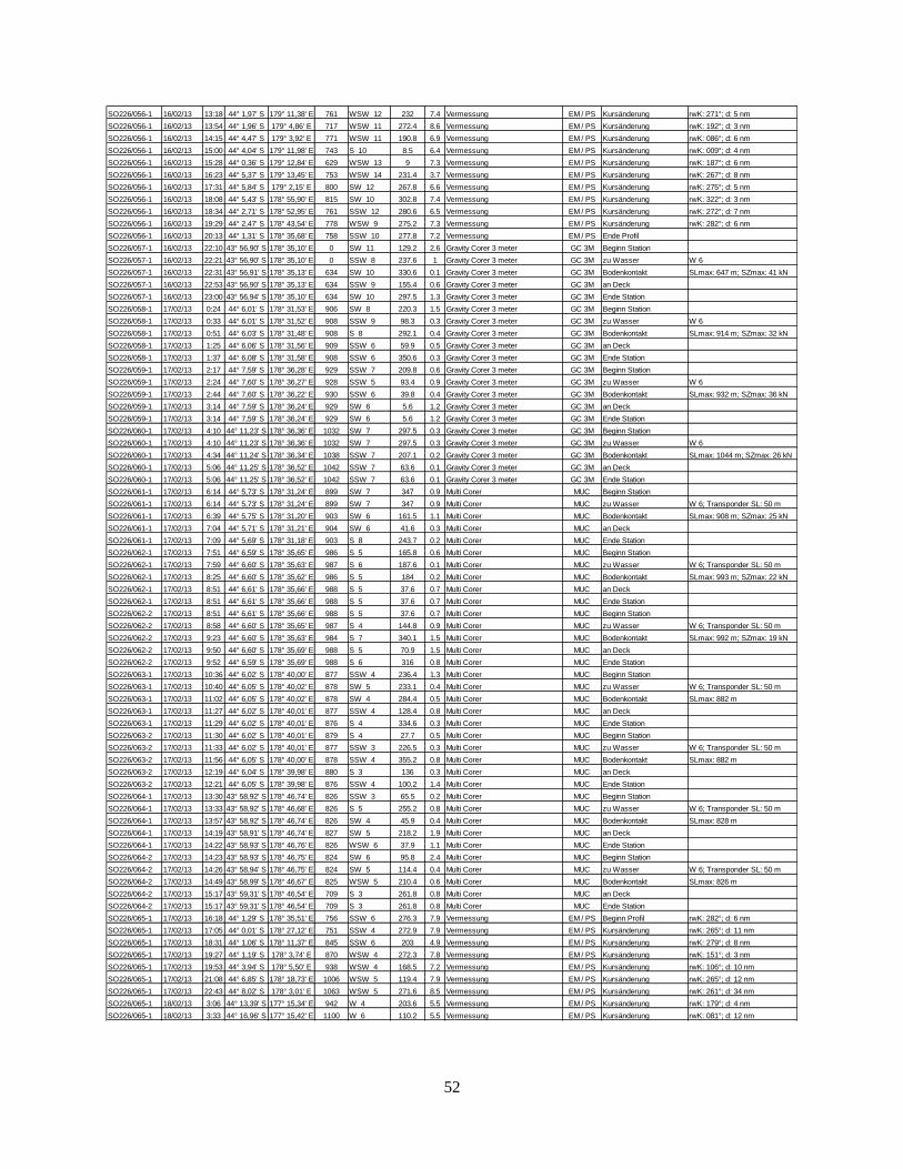
52
SO226/056-1 16/02/13 13:18 44° 1,97' S 179° 11,38' E 761 WSW 12 232 7.4 Vermessung EM / PS Kursänderung rwK: 271°; d: 5 nm
SO226/056-1 16/02/13 13:54 44° 1,96' S 179° 4,86' E 717 WSW 11 272.4 8.6 Vermessung EM / PS Kursänderung rwK: 192°; d: 3 nm
SO226/056-1 16/02/13 14:15 44° 4,47' S 179° 3,92' E 771 WSW 11 190.8 6.9 Vermessung EM / PS Kursänderung rwK: 086°; d: 6 nm
SO226/056-1 16/02/13 15:00 44° 4,04' S 179° 11,98' E 743 S 10 8.5 6.4 Vermessung EM / PS Kursänderung rwK: 009°; d: 4 nm
SO226/056-1 16/02/13 15:28 44° 0,36' S 179° 12,84' E 629 WSW 13 9 7.3 Vermessung EM / PS Kursänderung rwK: 187°; d: 6 nm
SO226/056-1 16/02/13 16:23 44° 5,37' S 179° 13,45' E 753 WSW 14 231.4 3.7 Vermessung EM / PS Kursänderung rwK: 267°; d: 8 nm
SO226/056-1 16/02/13 17:31 44° 5,84' S 179° 2,15' E 800 SW 12 267.8 6.6 Vermessung EM / PS Kursänderung rwK: 275°; d: 5 nm
SO226/056-1 16/02/13 18:08 44° 5,43' S 178° 55,90' E 815 SW 10 302.8 7.4 Vermessung EM / PS Kursänderung rwK: 322°; d: 3 nm
SO226/056-1 16/02/13 18:34 44° 2,71' S 178° 52,95' E 761 SSW 12 280.6 6.5 Vermessung EM / PS Kursänderung rwK: 272°; d: 7 nm
SO226/056-1 16/02/13 19:29 44° 2,47' S 178° 43,54' E 778 WSW 9 275.2 7.3 Vermessung EM / PS Kursänderung rwK: 282°; d: 6 nm
SO226/056-1 16/02/13 20:13 44° 1,31' S 178° 35,68' E 758 SSW 10 277.8 7.2 Vermessung EM / PS Ende Profil
SO226/057-1 16/02/13 22:10 43° 56,90' S 178° 35,10' E 0 SW 11 129.2 2.6 Gravity Corer 3 meter GC 3M Beginn Station
SO226/057-1 16/02/13 22:21 43° 56,90' S 178° 35,10' E 0 SSW 8 237.6 1 Gravity Corer 3 meter GC 3M zu Wasser W 6
SO226/057-1 16/02/13 22:31 43° 56,91' S 178° 35,13' E 634 SW 10 330.6 0.1 Gravity Corer 3 meter GC 3M Bodenkontakt SLmax: 647 m; SZmax: 41 kN
SO226/057-1 16/02/13 22:53 43° 56,90' S 178° 35,13' E 634 SSW 9 155.4 0.6 Gravity Corer 3 meter GC 3M an Deck
SO226/057-1 16/02/13 23:00 43° 56,94' S 178° 35,10' E 634 SW 10 297.5 1.3 Gravity Corer 3 meter GC 3M Ende Station
SO226/058-1 17/02/13 0:24 44° 6,01' S 178° 31,53' E 906 SW 8 220.3 1.5 Gravity Corer 3 meter GC 3M Beginn Station
SO226/058-1 17/02/13 0:33 44° 6,01' S 178° 31,52' E 908 SSW 9 98.3 0.3 Gravity Corer 3 meter GC 3M zu Wasser W 6
SO226/058-1 17/02/13 0:51 44° 6,03' S 178° 31,48' E 908 S 8 292.1 0.4 Gravity Corer 3 meter GC 3M Bodenkontakt SLmax: 914 m; SZmax: 32 kN
SO226/058-1 17/02/13 1:25 44° 6,06' S 178° 31,56' E 909 SSW 6 59.9 0.5 Gravity Corer 3 meter GC 3M an Deck
SO226/058-1 17/02/13 1:37 44° 6,08' S 178° 31,58' E 908 SSW 6 350.6 0.3 Gravity Corer 3 meter GC 3M Ende Station
SO226/059-1 17/02/13 2:17 44° 7,59' S 178° 36,28' E 929 SSW 7 209.8 0.6 Gravity Corer 3 meter GC 3M Beginn Station
SO226/059-1 17/02/13 2:24 44° 7,60' S 178° 36,27' E 928 SSW 5 93.4 0.9 Gravity Corer 3 meter GC 3M zu Wasser W 6
SO226/059-1 17/02/13 2:44 44° 7,60' S 178° 36,22' E 930 SSW 6 39.8 0.4 Gravity Corer 3 meter GC 3M Bodenkontakt SLmax: 932 m; SZmax: 36 kN
SO226/059-1 17/02/13 3:14 44° 7,59' S 178° 36,24' E 929 SW 6 5.6 1.2 Gravity Corer 3 meter GC 3M an Deck
SO226/059-1 17/02/13 3:14 44° 7,59' S 178° 36,24' E 929 SW 6 5.6 1.2 Gravity Corer 3 meter GC 3M Ende Station
SO226/060-1 17/02/13 4:10 44° 11,23' S 178° 36,36' E 1032 SW 7 297.5 0.3 Gravity Corer 3 meter GC 3M Beginn Station
SO226/060-1 17/02/13 4:10 44° 11,23' S 178° 36,36' E 1032 SW 7 297.5 0.3 Gravity Corer 3 meter GC 3M zu Wasser W 6
SO226/060-1 17/02/13 4:34 44° 11,24' S 178° 36,34' E 1038 SSW 7 207.1 0.2 Gravity Corer 3 meter GC 3M Bodenkontakt SLmax: 1044 m; SZmax: 26 kN
SO226/060-1 17/02/13 5:06 44° 11,25' S 178° 36,52' E 1042 SSW 7 63.6 0.1 Gravity Corer 3 meter GC 3M an Deck
SO226/060-1 17/02/13 5:06 44° 11,25' S 178° 36,52' E 1042 SSW 7 63.6 0.1 Gravity Corer 3 meter GC 3M Ende Station
SO226/061-1 17/02/13 6:14 44° 5,73' S 178° 31,24' E 899 SW 7 347 0.9 Multi Corer MUC Beginn Station
SO226/061-1 17/02/13 6:14 44° 5,73' S 178° 31,24' E 899 SW 7 347 0.9 Multi Corer MUC zu Wasser W 6; Transponder SL: 50 m
SO226/061-1 17/02/13 6:39 44° 5,75' S 178° 31,20' E 903 SW 6 161.5 1.1 Multi Corer MUC Bodenkontakt SLmax: 908 m; SZmax: 25 kN
SO226/061-1 17/02/13 7:04 44° 5,71' S 178° 31,21' E 904 SW 6 41.6 0.3 Multi Corer MUC an Deck
SO226/061-1 17/02/13 7:09 44° 5,69' S 178° 31,18' E 903 S 8 243.7 0.2 Multi Corer MUC Ende Station
SO226/062-1 17/02/13 7:51 44° 6,59' S 178° 35,65' E 986 S 5 165.8 0.6 Multi Corer MUC Beginn Station
SO226/062-1 17/02/13 7:59 44° 6,60' S 178° 35,63' E 987 S 6 187.6 0.1 Multi Corer MUC zu Wasser W 6; Transponder SL: 50 m
SO226/062-1 17/02/13 8:25 44° 6,60' S 178° 35,62' E 986 S 5 184 0.2 Multi Corer MUC Bodenkontakt SLmax: 993 m; SZmax: 22 kN
SO226/062-1 17/02/13 8:51 44° 6,61' S 178° 35,66' E 988 S 5 37.6 0.7 Multi Corer MUC an Deck
SO226/062-1 17/02/13 8:51 44° 6,61' S 178° 35,66' E 988 S 5 37.6 0.7 Multi Corer MUC Ende Station
SO226/062-2 17/02/13 8:51 44° 6,61' S 178° 35,66' E 988 S 5 37.6 0.7 Multi Corer MUC Beginn Station
SO226/062-2 17/02/13 8:58 44° 6,60' S 178° 35,65' E 987 S 4 144.8 0.9 Multi Corer MUC zu Wasser W 6; Transponder SL: 50 m
SO226/062-2 17/02/13 9:23 44° 6,60' S 178° 35,63' E 984 S 7 340.1 1.5 Multi Corer MUC Bodenkontakt SLmax: 992 m; SZmax: 19 kN
SO226/062-2 17/02/13 9:50 44° 6,60' S 178° 35,69' E 988 S 5 70.9 1.5 Multi Corer MUC an Deck
SO226/062-2 17/02/13 9:52 44° 6,59' S 178° 35,69' E 988 S 6 316 0.8 Multi Corer MUC Ende Station
SO226/063-1 17/02/13 10:36 44° 6,02' S 178° 40,00' E 877 SSW 4 236.4 1.3 Multi Corer MUC Beginn Station
SO226/063-1 17/02/13 10:40 44° 6,05' S 178° 40,02' E 878 SW 5 233.1 0.4 Multi Corer MUC zu Wasser W 6; Transponder SL: 50 m
SO226/063-1 17/02/13 11:02 44° 6,05' S 178° 40,02' E 878 SW 4 284.4 0.5 Multi Corer MUC Bodenkontakt SLmax: 882 m
SO226/063-1 17/02/13 11:27 44° 6,02' S 178° 40,01' E 877 SSW 4 128.4 0.8 Multi Corer MUC an Deck
SO226/063-1 17/02/13 11:29 44° 6,02' S 178° 40,01' E 876 S 4 334.6 0.3 Multi Corer MUC Ende Station
SO226/063-2 17/02/13 11:30 44° 6,02' S 178° 40,01' E 879 S 4 27.7 0.5 Multi Corer MUC Beginn Station
SO226/063-2 17/02/13 11:33 44° 6,02' S 178° 40,01' E 877 SSW 3 226.5 0.3 Multi Corer MUC zu Wasser W 6; Transponder SL: 50 m
SO226/063-2 17/02/13 11:56 44° 6,05' S 178° 40,00' E 878 SSW 4 355.2 0.8 Multi Corer MUC Bodenkontakt SLmax: 882 m
SO226/063-2 17/02/13 12:19 44° 6,04' S 178° 39,98' E 880 S 3 136 0.3 Multi Corer MUC an Deck
SO226/063-2 17/02/13 12:21 44° 6,05' S 178° 39,98' E 876 SSW 4 100.2 1.4 Multi Corer MUC Ende Station
SO226/064-1 17/02/13 13:30 43° 58,92' S 178° 46,74' E 826 SSW 3 65.5 0.2 Multi Corer MUC Beginn Station
SO226/064-1 17/02/13 13:33 43° 58,92' S 178° 46,68' E 826 S 5 255.2 0.8 Multi Corer MUC zu Wasser W 6; Transponder SL: 50 m
SO226/064-1 17/02/13 13:57 43° 58,92' S 178° 46,74' E 826 SW 4 45.9 0.4 Multi Corer MUC Bodenkontakt SLmax: 828 m
SO226/064-1 17/02/13 14:19 43° 58,91' S 178° 46,74' E 827 SW 5 218.2 1.9 Multi Corer MUC an Deck
SO226/064-1 17/02/13 14:22 43° 58,93' S 178° 46,76' E 826 WSW 6 37.9 1.1 Multi Corer MUC Ende Station
SO226/064-2 17/02/13 14:23 43° 58,93' S 178° 46,75' E 824 SW 6 95.8 2.4 Multi Corer MUC Beginn Station
SO226/064-2 17/02/13 14:26 43° 58,94' S 178° 46,75' E 824 SW 5 114.4 0.4 Multi Corer MUC zu Wasser W 6; Transponder SL: 50 m
SO226/064-2 17/02/13 14:49 43° 58,99' S 178° 46,67' E 825 WSW 5 210.4 0.6 Multi Corer MUC Bodenkontakt SLmax: 826 m
SO226/064-2 17/02/13 15:17 43° 59,31' S 178° 46,54' E 709 S 3 261.8 0.8 Multi Corer MUC an Deck
SO226/064-2 17/02/13 15:17 43° 59,31' S 178° 46,54' E 709 S 3 261.8 0.8 Multi Corer MUC Ende Station
SO226/065-1 17/02/13 16:18 44° 1,29' S 178° 35,51' E 756 SSW 6 276.3 7.9 Vermessung EM / PS Beginn Profil rwK: 282°; d: 6 nm
SO226/065-1 17/02/13 17:05 44° 0,01' S 178° 27,12' E 751 SSW 4 272.9 7.9 Vermessung EM / PS Kursänderung rwK: 265°; d: 11 nm
SO226/065-1 17/02/13 18:31 44° 1,06' S 178° 11,37' E 845 SSW 6 203 4.9 Vermessung EM / PS Kursänderung rwK: 279°; d: 8 nm
SO226/065-1 17/02/13 19:27 44° 1,19' S 178° 3,74' E 870 WSW 4 272.3 7.8 Vermessung EM / PS Kursänderung rwK: 151°; d: 3 nm
SO226/065-1 17/02/13 19:53 44° 3,94' S 178° 5,50' E 938 WSW 4 168.5 7.2 Vermessung EM / PS Kursänderung rwK: 106°; d: 10 nm
SO226/065-1 17/02/13 21:08 44° 6,85' S 178° 18,73' E 1006 WSW 5 119.4 7.9 Vermessung EM / PS Kursänderung rwK: 265°; d: 12 nm
SO226/065-1 17/02/13 22:43 44° 8,02' S 178° 3,01' E 1063 WSW 5 271.6 8.5 Vermessung EM / PS Kursänderung rwK: 261°; d: 34 nm
SO226/065-1 18/02/13 3:06 44° 13,39' S 177° 15,34' E 942 W 4 203.6 5.5 Vermessung EM / PS Kursänderung rwK: 179°; d: 4 nm
SO226/065-1 18/02/13 3:33 44° 16,96' S 177° 15,42' E 1100 W 6 110.2 5.5 Vermessung EM / PS Kursänderung rwK: 081°; d: 12 nm

53
SO226/065-1 18/02/13 5:01 44° 15,00' S 177° 31,72' E 1024 W 4 55.3 7.3 Vermessung EM / PS Kursänderung rwK: 347°; d: 5 nm
SO226/065-1 18/02/13 5:40 44° 10,06' S 177° 30,15' E 973 WSW 4 300.9 4.2 Vermessung EM / PS Kursänderung rwK: 259°; d: 14 nm
SO226/065-1 18/02/13 7:26 44° 12,73' S 177° 11,01' E 892 WNW 2 257.4 8.2 Vermessung EM / PS Ende Profil
SO226/066-1 18/02/13 8:09 44° 14,01' S 177° 15,30' E 955 W 3 202.7 0.6 CTD CTD Beginn Station
SO226/066-1 18/02/13 8:11 44° 14,02' S 177° 15,29' E 954 W 1 287.4 0.2 CTD CTD zu Wasser W 4
SO226/066-1 18/02/13 8:38 44° 14,02' S 177° 15,33' E 956 WNW 1 114.2 0.8 CTD CTD auf Tiefe SLmax: 952 m
SO226/066-1 18/02/13 8:48 44° 14,07' S 177° 15,40' E 957 WNW 3 126.6 1 CTD CTD Hieven
SO226/066-1 18/02/13 9:20 44° 14,29' S 177° 15,71' E 962 WNW 2 189.4 1 CTD CTD an Deck
SO226/066-1 18/02/13 9:23 44° 14,32' S 177° 15,73' E 964 WNW 2 242.8 0.2 CTD CTD Ende Station
SO226/067-1 18/02/13 9:32 44° 14,38' S 177° 15,71' E 965 WNW 2 185.8 1 Side Scan SSC Beginn Station
SO226/067-1 18/02/13 9:35 44° 14,39' S 177° 15,67' E 962 WNW 3 236.6 0.6 Side Scan SSC Side Scan z.W. W 2
SO226/067-1 18/02/13 9:45 44° 14,42' S 177° 15,63' E 964 WNW 3 242 0.5 Side Scan SSC Gewicht z.W.
SO226/067-1 18/02/13 10:45 44° 15,02' S 177° 12,59' E 965 WNW 2 262.4 3.2 Side Scan SSC Beginn Profil rwK: 242°; d: 13 nm
SO226/067-1 18/02/13 15:00 44° 21,05' S 176° 56,58' E 1029 NW 6 234.6 3.1 Side Scan SSC Kursänderung rwK: 062°; d: 15 nm; SL: 2165 m
SO226/067-1 18/02/13 19:58 44° 15,79' S 177° 14,72' E 1017 W 4 72.1 3 Side Scan SSC Kursänderung rwK: 242°; d: 16 nm; SL: 2235 m
SO226/067-1 19/02/13 1:29 44° 20,79' S 176° 55,27' E 991 NNW 2 223.6 3 Side Scan SSC Kursänderung rwK: 062°; d: 16 nm;,SL: 2026 m
SO226/067-1 19/02/13 6:45 44° 15,11' S 177° 14,33' E 981 NNE 5 59.3 2.8 Side Scan SSC Kursänderung rwK: 242°; d: 18 nm; SL: 2212 m
SO226/067-1 19/02/13 12:43 44° 19,87' S 176° 53,61' E 960 NNE 8 250.6 3.5 Side Scan SSC Kursänderung rwK: 062°; d: 15 nm; SL: 1641 m
SO226/067-1 19/02/13 17:58 44° 11,74' S 177° 10,96' E 871 N 8 56.5 3.2 Side Scan SSC Kursänderung rwK: 242°; d: 16 nm; SL: 2282 m
SO226/067-1 19/02/13 23:33 44° 20,29' S 176° 54,49' E 974 N 8 212.7 2.8 Side Scan SSC Kursänderung rwK: 062°; d: 15 nm; SL: 1810 m
SO226/067-1 20/02/13 4:29 44° 12,62' S 177° 10,52' E 888 N 7 56.5 3.4 Side Scan SSC Ende Profil
SO226/067-1 20/02/13 5:14 44° 11,63' S 177° 12,52' E 877 N 7 333.3 0.7 Side Scan SSC Gewicht a.D.
SO226/067-1 20/02/13 5:22 44° 11,52' S 177° 12,59' E 872 NNE 8 13.4 1.7 Side Scan SSC Side Scan a. D.
SO226/067-1 20/02/13 5:22 44° 11,52' S 177° 12,59' E 872 NNE 8 13.4 1.7 Side Scan SSC Ende Station
SO226/068-1 20/02/13 6:08 44° 14,39' S 177° 11,16' E 935 NNE 5 304.8 0.3 Multi Corer MUC Beginn Station
SO226/068-1 20/02/13 6:08 44° 14,39' S 177° 11,16' E 935 NNE 5 304.8 0.3 Multi Corer MUC zu Wasser W 6; Transponder SL: 50 m
SO226/068-1 20/02/13 6:32 44° 14,34' S 177° 11,17' E 933 NNE 8 258.6 1.3 Multi Corer MUC Bodenkontakt SLmax: 943 m; SZmax: 20 kN
SO226/068-1 20/02/13 7:00 44° 14,34' S 177° 11,09' E 934 NNE 8 45.1 0.7 Multi Corer MUC an Deck
SO226/068-1 20/02/13 7:00 44° 14,34' S 177° 11,09' E 934 NNE 8 45.1 0.7 Multi Corer MUC Ende Station
SO226/069-1 20/02/13 7:22 44° 14,39' S 177° 10,39' E 968 NE 9 298.9 0.9 Multi Corer MUC Beginn Station
SO226/069-1 20/02/13 7:26 44° 14,37' S 177° 10,40' E 966 NNE 9 86.2 1.5 Multi Corer MUC zu Wasser W 6; Transponder SL: 50 m
SO226/069-1 20/02/13 7:50 44° 14,37' S 177° 10,38' E 967 NNE 7 208.1 0.6 Multi Corer MUC Bodenkontakt SLmax: 968 m; SZmax: 22 kN
SO226/069-1 20/02/13 8:14 44° 14,39' S 177° 10,27' E 972 NNE 9 335.7 0.9 Multi Corer MUC an Deck
SO226/069-1 20/02/13 8:17 44° 14,38' S 177° 10,28' E 971 NNE 9 82 1 Multi Corer MUC Ende Station
SO226/070-1 20/02/13 8:18 44° 14,38' S 177° 10,28' E 971 NNE 9 96.6 0.9 Multi Corer MUC Beginn Station
SO226/070-1 20/02/13 8:22 44° 14,38' S 177° 10,28' E 971 NNE 9 92.9 0.8 Multi Corer MUC zu Wasser W 6; Transponder SL: 50 m
SO226/070-1 20/02/13 8:39 44° 14,37' S 177° 10,29' E 971 N 7 328.2 0.8 Multi Corer MUC Bodenkontakt SLmax: 970 m; SZmax: 20kN
SO226/070-1 20/02/13 9:09 44° 14,35' S 177° 10,32' E 968 N 7 118.2 0.8 Multi Corer MUC an Deck
SO226/070-1 20/02/13 9:12 44° 14,38' S 177° 10,33' E 970 N 7 191.9 0.7 Multi Corer MUC Ende Station
SO226/070-2 20/02/13 9:19 44° 14,35' S 177° 10,31' E 969 N 8 277.8 0.9 Multi Corer MUC Beginn Station
SO226/070-2 20/02/13 9:25 44° 14,37' S 177° 10,31' E 968 NNE 8 10.4 1.1 Multi Corer MUC zu Wasser W 6; Transponder SL: 50 m
SO226/070-2 20/02/13 9:51 44° 14,39' S 177° 10,31' E 971 N 6 123.6 0.7 Multi Corer MUC Bodenkontakt SLmax: 972 m; Szmax: 20 kN
SO226/070-2 20/02/13 10:10 44° 14,34' S 177° 10,24' E 971 N 7 83.9 0.9 Multi Corer MUC an Deck
SO226/070-2 20/02/13 10:11 44° 14,34' S 177° 10,24' E 972 N 7 86 0.5 Multi Corer MUC Ende Station
SO226/071-1 20/02/13 10:49 44° 14,40' S 177° 9,04' E 968 N 7 40.8 0.8 Multi Corer MUC Beginn Station
SO226/071-1 20/02/13 10:53 44° 14,39' S 177° 9,02' E 968 N 7 78.7 0.2 Multi Corer MUC zu Wasser W 6; Transponder SL: 50 m
SO226/071-1 20/02/13 11:17 44° 14,38' S 177° 9,01' E 967 N 7 28.2 0.3 Multi Corer MUC Bodenkontakt SLmax: 971 m
SO226/071-1 20/02/13 11:43 44° 14,44' S 177° 8,89' E 969 NNE 9 115.6 1 Multi Corer MUC an Deck
SO226/071-1 20/02/13 11:44 44° 14,45' S 177° 8,87' E 970 N 9 235.8 1.3 Multi Corer MUC Ende Station
SO226/072-1 20/02/13 11:54 44° 14,40' S 177° 8,54' E 962 N 8 354 0.3 Multi Corer MUC Beginn Station
SO226/072-1 20/02/13 11:56 44° 14,39' S 177° 8,54' E 961 N 8 355.9 0.2 Multi Corer MUC zu Wasser W 6; Transponder SL: 50 m
SO226/072-1 20/02/13 12:19 44° 14,38' S 177° 8,55' E 960 N 9 213.3 0.3 Multi Corer MUC Bodenkontakt SLmax: 966 m
SO226/072-1 20/02/13 12:44 44° 14,43' S 177° 8,44' E 965 N 9 242.5 1.2 Multi Corer MUC an Deck
SO226/072-1 20/02/13 12:45 44° 14,42' S 177° 8,43' E 963 N 9 0.5 0.9 Multi Corer MUC Ende Station
SO226/073-1 20/02/13 12:46 44° 14,41' S 177° 8,43' E 962 NNE 9 51.5 1.9 Multi Corer MUC Beginn Station
SO226/073-1 20/02/13 12:57 44° 14,39' S 177° 8,42' E 964 N 9 323.7 0.7 Multi Corer MUC zu Wasser W 6; Transponder SL: 50 m
SO226/073-1 20/02/13 13:22 44° 14,38' S 177° 8,42' E 965 N 9 290.9 0.8 Multi Corer MUC Bodenkontakt SLmax: 963 m
SO226/073-1 20/02/13 13:51 44° 14,39' S 177° 8,43' E 964 N 8 273.6 1.1 Multi Corer MUC an Deck
SO226/073-1 20/02/13 13:52 44° 14,39' S 177° 8,43' E 963 N 8 227.9 2 Multi Corer MUC Ende Station
SO226/073-2 20/02/13 13:53 44° 14,39' S 177° 8,43' E 964 N 7 213.1 1.8 Piston Corer 9 meter PC 9M Beginn Station
SO226/073-2 20/02/13 14:40 44° 14,39' S 177° 8,43' E 961 N 8 119.3 0.8 Piston Corer 9 meter PC 9M zu Wasser W 6; Transponder SL: 50 m
SO226/073-2 20/02/13 15:03 44° 14,37' S 177° 8,42' E 963 N 8 19.4 1.7 Piston Corer 9 meter PC 9M Bodenkontakt SLmax: 946 m; SZmax: 50 kN
SO226/073-2 20/02/13 15:43 44° 14,40' S 177° 8,44' E 960 N 8 31.4 0.2 Piston Corer 9 meter PC 9M an Deck
SO226/073-2 20/02/13 15:43 44° 14,40' S 177° 8,44' E 960 N 8 31.4 0.2 Piston Corer 9 meter PC 9M Ende Station
SO226/074-1 20/02/13 16:37 44° 14,37' S 177° 8,54' E 956 N 8 67 1.3 Piston Corer 9 meter PC 9M Beginn Station
SO226/074-1 20/02/13 16:37 44° 14,37' S 177° 8,54' E 956 N 8 67 1.3 Piston Corer 9 meter PC 9M zu Wasser W 6; Transponder SL: 50 m
SO226/074-1 20/02/13 17:02 44° 14,37' S 177° 8,53' E 957 N 8 65.8 1.2 Piston Corer 9 meter PC 9M Bodenkontakt SLmax: 945 m; SZmax: 48 kN
SO226/074-1 20/02/13 17:41 44° 14,38' S 177° 8,55' E 958 N 7 39.7 0.7 Piston Corer 9 meter PC 9M an Deck
SO226/074-1 20/02/13 17:41 44° 14,38' S 177° 8,55' E 958 N 7 39.7 0.7 Piston Corer 9 meter PC 9M Ende Station
SO226/075-1 20/02/13 19:02 44° 14,38' S 177° 9,02' E 963 N 6 89.5 1 Piston Corer 9 meter PC 9M Beginn Station
SO226/075-1 20/02/13 19:14 44° 14,38' S 177° 9,01' E 964 N 7 271 0.8 Piston Corer 9 meter PC 9M zu Wasser W 6; Transponder SL: 50 m
SO226/075-1 20/02/13 19:39 44° 14,37' S 177° 9,05' E 963 N 6 32.3 1.2 Piston Corer 9 meter PC 9M Bodenkontakt SLmax: 948 m; SZmax: 39 kN
SO226/075-1 20/02/13 20:14 44° 14,34' S 177° 9,04' E 964 N 6 62.7 0.9 Piston Corer 9 meter PC 9M an Deck
SO226/075-1 20/02/13 20:20 44° 14,30' S 177° 9,07' E 963 N 5 131 0.6 Piston Corer 9 meter PC 9M Ende Station
SO226/075-2 20/02/13 20:59 44° 14,37' S 177° 9,02' E 965 N 6 240 0.4 Piston Corer 9 meter PC 9M Beginn Station
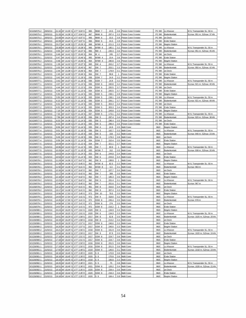
54
SO226/075-2 20/02/13 21:10 44° 14,35' S 177° 9,04' E 965 NNW 7 24.5 0.6 Piston Corer 9 meter PC 9M zu Wasser W 6; Transponder SL: 50 m
SO226/075-2 20/02/13 21:33 44° 14,38' S 177° 8,94' E 967 NNW 8 297.4 0.3 Piston Corer 9 meter PC 9M Bodenkontakt SLmax: 951 m; SZmax: 37 kN
SO226/075-2 20/02/13 22:09 44° 14,24' S 177° 8,97' E 966 NNW 6 33.3 0.9 Piston Corer 9 meter PC 9M an Deck
SO226/075-2 20/02/13 22:09 44° 14,24' S 177° 8,97' E 966 NNW 6 33.3 0.9 Piston Corer 9 meter PC 9M Ende Station
SO226/076-1 20/02/13 23:27 44° 14,38' S 177° 10,35' E 968 WNW 4 221.3 0.3 Piston Corer 9 meter PC 9M Beginn Station
SO226/076-1 20/02/13 23:39 44° 14,40' S 177° 10,38' E 966 WNW 6 180.1 0.2 Piston Corer 9 meter PC 9M zu Wasser W 6; Transponder SL: 50 m
SO226/076-1 21/02/13 0:05 44° 14,37' S 177° 10,37' E 966 NW 4 230.3 0.6 Piston Corer 9 meter PC 9M Bodenkontakt SLmax: 951 m; SZmax: 45 kN
SO226/076-1 21/02/13 0:46 44° 14,41' S 177° 10,45' E 964 W 4 245 0.7 Piston Corer 9 meter PC 9M an Deck
SO226/076-1 21/02/13 0:47 44° 14,42' S 177° 10,46' E 965 WNW 4 19.4 0.6 Piston Corer 9 meter PC 9M Ende Station
SO226/076-2 21/02/13 0:48 44° 14,42' S 177° 10,46' E 964 WNW 4 280.8 0.6 Piston Corer 9 meter PC 9M Beginn Station
SO226/076-2 21/02/13 1:39 44° 14,33' S 177° 10,37' E 965 SW 4 263.2 0.7 Piston Corer 9 meter PC 9M zu Wasser W 6; Transponder SL: 50 m
SO226/076-2 21/02/13 2:03 44° 14,38' S 177° 10,40' E 967 SW 7 203.1 0.3 Piston Corer 9 meter PC 9M Bodenkontakt SLmax: 950 m; SZmax: 42 kN
SO226/076-2 21/02/13 2:44 44° 14,38' S 177° 10,46' E 964 SW 7 178.9 0.1 Piston Corer 9 meter PC 9M an Deck
SO226/076-2 21/02/13 2:45 44° 14,38' S 177° 10,46' E 964 SW 7 98.8 1 Piston Corer 9 meter PC 9M Ende Station
SO226/077-1 21/02/13 3:42 44° 14,37' S 177° 11,18' E 936 SSW 7 24.9 0.2 Piston Corer 9 meter PC 9M Beginn Station
SO226/077-1 21/02/13 3:42 44° 14,37' S 177° 11,18' E 936 SSW 7 24.9 0.2 Piston Corer 9 meter PC 9M zu Wasser W 6; Transponder SL: 50 m
SO226/077-1 21/02/13 4:07 44° 14,37' S 177° 11,13' E 936 SSW 6 330.8 0.2 Piston Corer 9 meter PC 9M Bodenkontakt SLmax: 921 m; SZmax: 40 kN
SO226/077-1 21/02/13 4:44 44° 14,37' S 177° 11,13' E 934 SSW 6 200.5 0.7 Piston Corer 9 meter PC 9M an Deck
SO226/077-1 21/02/13 4:44 44° 14,37' S 177° 11,13' E 934 SSW 6 200.5 0.7 Piston Corer 9 meter PC 9M Ende Station
SO226/077-2 21/02/13 5:50 44° 14,36' S 177° 11,14' E 935 SSW 5 238.1 0.9 Piston Corer 9 meter PC 9M Beginn Station
SO226/077-2 21/02/13 5:50 44° 14,36' S 177° 11,14' E 935 SSW 5 238.1 0.9 Piston Corer 9 meter PC 9M zu Wasser W 6; Transponder SL: 50 m
SO226/077-2 21/02/13 6:15 44° 14,37' S 177° 11,14' E 936 SSW 5 206.1 0.7 Piston Corer 9 meter PC 9M Bodenkontakt SLmax: 921 m; SZmax: 49 kN
SO226/077-2 21/02/13 6:52 44° 14,37' S 177° 11,14' E 935 SSW 5 303.3 0.4 Piston Corer 9 meter PC 9M an Deck
SO226/077-2 21/02/13 6:52 44° 14,37' S 177° 11,14' E 935 SSW 5 303.3 0.4 Piston Corer 9 meter PC 9M Ende Station
SO226/077-3 21/02/13 7:19 44° 14,36' S 177° 11,14' E 934 SSW 5 249.8 0.3 Piston Corer 9 meter PC 9M Beginn Station
SO226/077-3 21/02/13 7:32 44° 14,37' S 177° 11,14' E 937 SSW 5 173.1 0.2 Piston Corer 9 meter PC 9M zu Wasser W 6; Transponder SL: 50 m
SO226/077-3 21/02/13 7:56 44° 14,39' S 177° 11,16' E 936 SW 5 287.4 0.4 Piston Corer 9 meter PC 9M Bodenkontakt SLmax: 920 m; SZmax: 38 kN
SO226/077-3 21/02/13 8:33 44° 14,38' S 177° 11,14' E 935 SW 5 296.4 0.5 Piston Corer 9 meter PC 9M an Deck
SO226/077-3 21/02/13 8:33 44° 14,38' S 177° 11,14' E 935 SW 5 296.4 0.5 Piston Corer 9 meter PC 9M Ende Station
SO226/077-4 21/02/13 8:56 44° 14,37' S 177° 11,14' E 935 SW 4 24.9 0.5 Multi Corer MUC Beginn Station
SO226/077-4 21/02/13 9:01 44° 14,38' S 177° 11,16' E 936 SW 5 162.7 0.3 Multi Corer MUC zu Wasser W 6; Transponder SL: 50 m
SO226/077-4 21/02/13 9:24 44° 14,38' S 177° 11,15' E 935 SW 5 319 0.2 Multi Corer MUC Bodenkontakt SLmax: 940 m; SZmax: 23 kN
SO226/077-4 21/02/13 9:49 44° 14,42' S 177° 11,19' E 936 SW 6 178.3 0.9 Multi Corer MUC an Deck
SO226/077-4 21/02/13 9:59 44° 14,36' S 177° 11,14' E 934 SSW 7 310.4 0.5 Multi Corer MUC Ende Station
SO226/077-5 21/02/13 10:04 44° 14,34' S 177° 11,12' E 934 SW 7 321.1 0.7 Multi Corer MUC Beginn Station
SO226/077-5 21/02/13 10:06 44° 14,33' S 177° 11,12' E 935 SW 7 90.9 1 Multi Corer MUC zu Wasser W 6; Transponder SL: 50 m
SO226/077-5 21/02/13 10:29 44° 14,37' S 177° 11,15' E 935 WSW 7 312 0.5 Multi Corer MUC Bodenkontakt SLmax: 938 m; SZmax: 20 kN
SO226/077-5 21/02/13 10:53 44° 14,34' S 177° 11,14' E 933 SW 6 244.8 0.4 Multi Corer MUC an Deck
SO226/077-5 21/02/13 10:53 44° 14,34' S 177° 11,14' E 933 SW 6 244.8 0.4 Multi Corer MUC Ende Station
SO226/078-1 21/02/13 11:24 44° 14,36' S 177° 8,47' E 962 SW 9 198.8 1 Multi Corer MUC Beginn Station
SO226/078-1 21/02/13 11:28 44° 14,36' S 177° 8,45' E 962 WSW 8 82.3 0.2 Multi Corer MUC zu Wasser W 6; Transponder SL: 50 m
SO226/078-1 21/02/13 11:50 44° 14,38' S 177° 8,41' E 962 WSW 8 6.3 0.1 Multi Corer MUC Bodenkontakt SLmax: 963 m
SO226/078-1 21/02/13 12:16 44° 14,38' S 177° 8,42' E 962 SW 7 107.7 0.4 Multi Corer MUC an Deck
SO226/078-1 21/02/13 12:17 44° 14,38' S 177° 8,42' E 962 SW 7 309 0.5 Multi Corer MUC Ende Station
SO226/078-2 21/02/13 12:18 44° 14,38' S 177° 8,42' E 962 SW 7 185.3 0.5 Multi Corer MUC Beginn Station
SO226/078-2 21/02/13 12:23 44° 14,37' S 177° 8,42' E 962 SW 5 331.4 0.1 Multi Corer MUC zu Wasser W 6; Transponder SL: 50 m
SO226/078-2 21/02/13 12:46 44° 14,39' S 177° 8,40' E 962 SW 7 201.6 0.1 Multi Corer MUC Bodenkontakt SLmax: 967 m
SO226/078-2 21/02/13 13:12 44° 14,39' S 177° 8,41' E 961 SW 8 316.6 0.4 Multi Corer MUC an Deck
SO226/078-2 21/02/13 13:17 44° 14,38' S 177° 8,41' E 962 SW 8 307.4 0.3 Multi Corer MUC Ende Station
SO226/079-1 21/02/13 13:56 44° 17,53' S 177° 3,45' E 973 SW 10 78.5 0.5 Multi Corer MUC Beginn Station
SO226/079-1 21/02/13 14:03 44° 17,54' S 177° 3,41' E 972 SW 9 318.6 0.2 Multi Corer MUC zu Wasser W 6; Transponder SL: 50 m
SO226/079-1 21/02/13 14:26 44° 17,55' S 177° 3,41' E 972 SSW 8 245.4 0.5 Multi Corer MUC Bodenkontakt SLmax: 978 m
SO226/079-1 21/02/13 14:56 44° 17,55' S 177° 3,41' E 971 SSW 8 274 0.5 Multi Corer MUC an Deck
SO226/079-1 21/02/13 14:57 44° 17,56' S 177° 3,41' E 972 SSW 8 216.2 1 Multi Corer MUC Ende Station
SO226/080-1 21/02/13 15:24 44° 18,25' S 177° 2,61' E 1020 SW 6 134.9 0.3 Multi Corer MUC Beginn Station
SO226/080-1 21/02/13 15:24 44° 18,25' S 177° 2,61' E 1020 SW 6 134.9 0.3 Multi Corer MUC zu Wasser W 6; Transponder SL: 50 m
SO226/080-1 21/02/13 15:51 44° 18,29' S 177° 2,58' E 1017 SW 8 52.8 0.5 Multi Corer MUC Bodenkontakt SLmax: 1025 m; SZmax: 20 kN
SO226/080-1 21/02/13 16:19 44° 18,29' S 177° 2,58' E 1018 SW 8 213.2 0.4 Multi Corer MUC an Deck
SO226/080-1 21/02/13 16:20 44° 18,29' S 177° 2,57' E 1017 SSW 8 246.6 0.3 Multi Corer MUC Ende Station
SO226/080-2 21/02/13 16:20 44° 18,29' S 177° 2,57' E 1017 SSW 8 246.6 0.3 Multi Corer MUC Beginn Station
SO226/080-2 21/02/13 16:21 44° 18,29' S 177° 2,56' E 1018 SSW 8 161.9 0.6 Multi Corer MUC zu Wasser W 6; Transponder SL: 50 m
SO226/080-2 21/02/13 16:50 44° 18,28' S 177° 2,59' E 1017 SW 9 97.9 0.5 Multi Corer MUC Bodenkontakt SLmax: 1020 m; SZmax: 24 kN
SO226/080-2 21/02/13 17:18 44° 18,33' S 177° 2,51' E 1017 SSW 8 224.7 0.6 Multi Corer MUC an Deck
SO226/080-2 21/02/13 17:18 44° 18,33' S 177° 2,51' E 1017 SSW 8 224.7 0.6 Multi Corer MUC Ende Station
SO226/081-1 21/02/13 17:19 44° 18,34' S 177° 2,50' E 1016 SSW 8 201.5 0.6 Multi Corer MUC Beginn Station
SO226/081-1 21/02/13 17:19 44° 18,34' S 177° 2,50' E 1016 SSW 8 201.5 0.6 Multi Corer MUC zu Wasser W 6; Transponder SL: 50 m
SO226/081-1 21/02/13 17:50 44° 18,37' S 177° 2,48' E 1019 SSW 9 146.6 0.1 Multi Corer MUC Bodenkontakt SLmax: 1018 m; SZmax: 23 kN
SO226/081-1 21/02/13 18:18 44° 18,45' S 177° 2,39' E 1020 S 8 170.9 0.6 Multi Corer MUC an Deck
SO226/081-1 21/02/13 18:18 44° 18,45' S 177° 2,39' E 1020 S 8 170.9 0.6 Multi Corer MUC Ende Station
SO226/082-1 21/02/13 18:19 44° 18,45' S 177° 2,38' E 1018 S 9 166.8 0.3 Multi Corer MUC Beginn Station
SO226/082-1 21/02/13 18:20 44° 18,45' S 177° 2,38' E 1021 S 9 75 0.8 Multi Corer MUC zu Wasser W 6; Transponder SL: 50 m
SO226/082-1 21/02/13 18:51 44° 18,49' S 177° 2,38' E 1021 SSW 8 126.2 0.4 Multi Corer MUC Bodenkontakt SLmax: 1026 m; SZmax: 21 kN
SO226/082-1 21/02/13 19:16 44° 18,44' S 177° 2,35' E 1020 SSW 8 234.4 0.6 Multi Corer MUC an Deck
SO226/082-1 21/02/13 19:16 44° 18,44' S 177° 2,35' E 1020 SSW 8 234.4 0.6 Multi Corer MUC Ende Station
SO226/082-2 21/02/13 19:18 44° 18,44' S 177° 2,35' E 1020 S 9 184.4 0.8 Multi Corer MUC Beginn Station
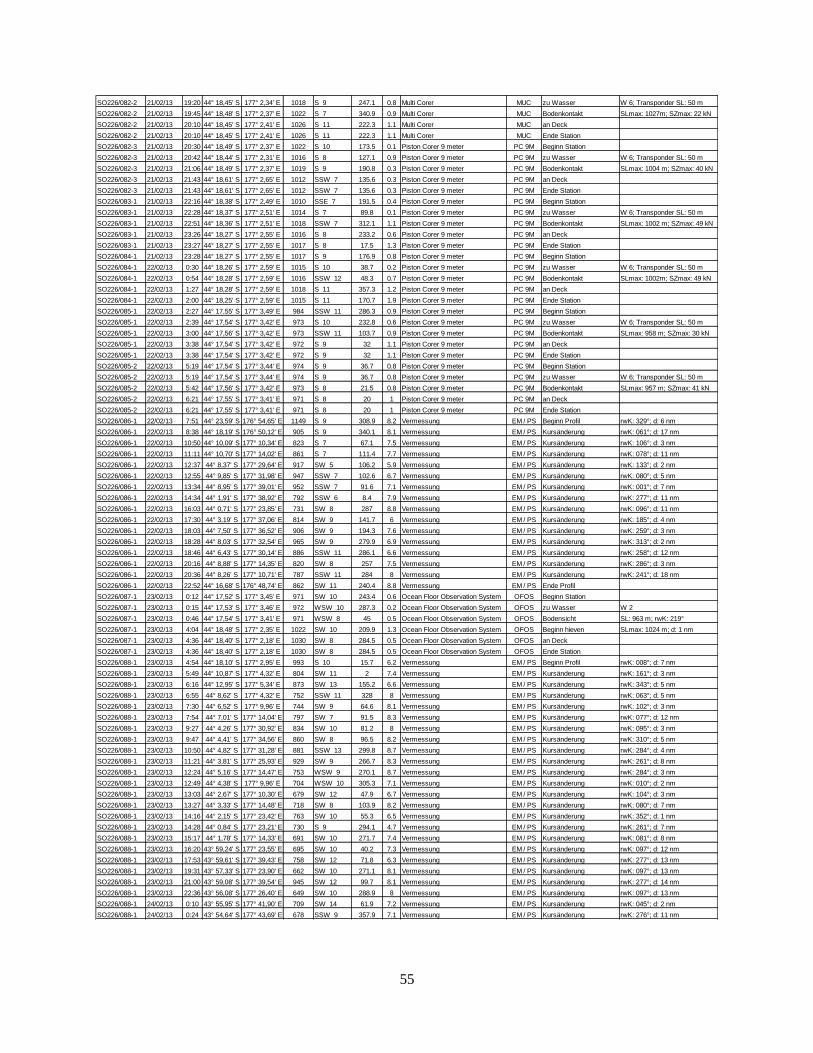
55
SO226/082-2 21/02/13 19:20 44° 18,45' S 177° 2,34' E 1018 S 9 247.1 0.8 Multi Corer MUC zu Wasser W 6; Transponder SL: 50 m
SO226/082-2 21/02/13 19:45 44° 18,48' S 177° 2,37' E 1022 S 7 340.9 0.9 Multi Corer MUC Bodenkontakt SLmax: 1027m; SZmax: 22 kN
SO226/082-2 21/02/13 20:10 44° 18,45' S 177° 2,41' E 1026 S 11 222.3 1.1 Multi Corer MUC an Deck
SO226/082-2 21/02/13 20:10 44° 18,45' S 177° 2,41' E 1026 S 11 222.3 1.1 Multi Corer MUC Ende Station
SO226/082-3 21/02/13 20:30 44° 18,49' S 177° 2,37' E 1022 S 10 173.5 0.1 Piston Corer 9 meter PC 9M Beginn Station
SO226/082-3 21/02/13 20:42 44° 18,44' S 177° 2,31' E 1016 S 8 127.1 0.9 Piston Corer 9 meter PC 9M zu Wasser W 6; Transponder SL: 50 m
SO226/082-3 21/02/13 21:06 44° 18,49' S 177° 2,37' E 1019 S 9 190.8 0.3 Piston Corer 9 meter PC 9M Bodenkontakt SLmax: 1004 m; SZmax: 40 kN
SO226/082-3 21/02/13 21:43 44° 18,61' S 177° 2,65' E 1012 SSW 7 135.6 0.3 Piston Corer 9 meter PC 9M an Deck
SO226/082-3 21/02/13 21:43 44° 18,61' S 177° 2,65' E 1012 SSW 7 135.6 0.3 Piston Corer 9 meter PC 9M Ende Station
SO226/083-1 21/02/13 22:16 44° 18,38' S 177° 2,49' E 1010 SSE 7 191.5 0.4 Piston Corer 9 meter PC 9M Beginn Station
SO226/083-1 21/02/13 22:28 44° 18,37' S 177° 2,51' E 1014 S 7 89.8 0.1 Piston Corer 9 meter PC 9M zu Wasser W 6; Transponder SL: 50 m
SO226/083-1 21/02/13 22:51 44° 18,36' S 177° 2,51' E 1018 SSW 7 312.1 1.1 Piston Corer 9 meter PC 9M Bodenkontakt SLmax: 1002 m; SZmax: 49 kN
SO226/083-1 21/02/13 23:26 44° 18,27' S 177° 2,55' E 1016 S 8 233.2 0.6 Piston Corer 9 meter PC 9M an Deck
SO226/083-1 21/02/13 23:27 44° 18,27' S 177° 2,55' E 1017 S 8 17.5 1.3 Piston Corer 9 meter PC 9M Ende Station
SO226/084-1 21/02/13 23:28 44° 18,27' S 177° 2,55' E 1017 S 9 176.9 0.8 Piston Corer 9 meter PC 9M Beginn Station
SO226/084-1 22/02/13 0:30 44° 18,26' S 177° 2,59' E 1015 S 10 38.7 0.2 Piston Corer 9 meter PC 9M zu Wasser W 6; Transponder SL: 50 m
SO226/084-1 22/02/13 0:54 44° 18,28' S 177° 2,59' E 1016 SSW 12 48.3 0.7 Piston Corer 9 meter PC 9M Bodenkontakt SLmax: 1002m; SZmax: 49 kN
SO226/084-1 22/02/13 1:27 44° 18,28' S 177° 2,59' E 1018 S 11 357.3 1.2 Piston Corer 9 meter PC 9M an Deck
SO226/084-1 22/02/13 2:00 44° 18,25' S 177° 2,59' E 1015 S 11 170.7 1.9 Piston Corer 9 meter PC 9M Ende Station
SO226/085-1 22/02/13 2:27 44° 17,55' S 177° 3,49' E 984 SSW 11 286.3 0.9 Piston Corer 9 meter PC 9M Beginn Station
SO226/085-1 22/02/13 2:39 44° 17,54' S 177° 3,42' E 973 S 10 232.8 0.6 Piston Corer 9 meter PC 9M zu Wasser W 6; Transponder SL: 50 m
SO226/085-1 22/02/13 3:00 44° 17,56' S 177° 3,42' E 973 SSW 11 103.7 0.9 Piston Corer 9 meter PC 9M Bodenkontakt SLmax: 958 m; SZmax: 30 kN
SO226/085-1 22/02/13 3:38 44° 17,54' S 177° 3,42' E 972 S 9 32 1.1 Piston Corer 9 meter PC 9M an Deck
SO226/085-1 22/02/13 3:38 44° 17,54' S 177° 3,42' E 972 S 9 32 1.1 Piston Corer 9 meter PC 9M Ende Station
SO226/085-2 22/02/13 5:19 44° 17,54' S 177° 3,44' E 974 S 9 36.7 0.8 Piston Corer 9 meter PC 9M Beginn Station
SO226/085-2 22/02/13 5:19 44° 17,54' S 177° 3,44' E 974 S 9 36.7 0.8 Piston Corer 9 meter PC 9M zu Wasser W 6; Transponder SL: 50 m
SO226/085-2 22/02/13 5:42 44° 17,56' S 177° 3,42' E 973 S 8 21.5 0.8 Piston Corer 9 meter PC 9M Bodenkontakt SLmax: 957 m; SZmax: 41 kN
SO226/085-2 22/02/13 6:21 44° 17,55' S 177° 3,41' E 971 S 8 20 1 Piston Corer 9 meter PC 9M an Deck
SO226/085-2 22/02/13 6:21 44° 17,55' S 177° 3,41' E 971 S 8 20 1 Piston Corer 9 meter PC 9M Ende Station
SO226/086-1 22/02/13 7:51 44° 23,59' S 176° 54,65' E 1149 S 9 308.9 8.2 Vermessung EM / PS Beginn Profil rwK: 329°; d: 6 nm
SO226/086-1 22/02/13 8:38 44° 18,19' S 176° 50,12' E 905 S 9 340.1 8.1 Vermessung EM / PS Kursänderung rwK: 061°; d: 17 nm
SO226/086-1 22/02/13 10:50 44° 10,09' S 177° 10,34' E 823 S 7 67.1 7.5 Vermessung EM / PS Kursänderung rwK: 106°; d: 3 nm
SO226/086-1 22/02/13 11:11 44° 10,70' S 177° 14,02' E 861 S 7 111.4 7.7 Vermessung EM / PS Kursänderung rwK: 078°; d: 11 nm
SO226/086-1 22/02/13 12:37 44° 8,37' S 177° 29,64' E 917 SW 5 106.2 5.9 Vermessung EM / PS Kursänderung rwK: 133°; d: 2 nm
SO226/086-1 22/02/13 12:55 44° 9,85' S 177° 31,98' E 947 SSW 7 102.6 6.7 Vermessung EM / PS Kursänderung rwK: 080°; d: 5 nm
SO226/086-1 22/02/13 13:34 44° 8,95' S 177° 39,01' E 952 SSW 7 91.6 7.1 Vermessung EM / PS Kursänderung rwK: 001°; d: 7 nm
SO226/086-1 22/02/13 14:34 44° 1,91' S 177° 38,92' E 792 SSW 6 8.4 7.9 Vermessung EM / PS Kursänderung rwK: 277°; d: 11 nm
SO226/086-1 22/02/13 16:03 44° 0,71' S 177° 23,85' E 731 SW 8 287 8.8 Vermessung EM / PS Kursänderung rwK: 096°; d: 11 nm
SO226/086-1 22/02/13 17:30 44° 3,19' S 177° 37,06' E 814 SW 9 141.7 6 Vermessung EM / PS Kursänderung rwK: 185°; d: 4 nm
SO226/086-1 22/02/13 18:03 44° 7,50' S 177° 36,52' E 906 SW 9 194.3 7.6 Vermessung EM / PS Kursänderung rwK: 259°; d: 3 nm
SO226/086-1 22/02/13 18:28 44° 8,03' S 177° 32,54' E 965 SW 9 279.9 6.9 Vermessung EM / PS Kursänderung rwK: 313°; d: 2 nm
SO226/086-1 22/02/13 18:46 44° 6,43' S 177° 30,14' E 886 SSW 11 286.1 6.6 Vermessung EM / PS Kursänderung rwK: 258°; d: 12 nm
SO226/086-1 22/02/13 20:16 44° 8,88' S 177° 14,35' E 820 SW 8 257 7.5 Vermessung EM / PS Kursänderung rwK: 286°; d: 3 nm
SO226/086-1 22/02/13 20:36 44° 8,26' S 177° 10,71' E 787 SSW 11 284 8 Vermessung EM / PS Kursänderung rwK: 241°; d: 18 nm
SO226/086-1 22/02/13 22:52 44° 16,68' S 176° 48,74' E 862 SW 11 240.4 8.8 Vermessung EM / PS Ende Profil
SO226/087-1 23/02/13 0:12 44° 17,52' S 177° 3,45' E 971 SW 10 243.4 0.6 Ocean Floor Observation System OFOS Beginn Station
SO226/087-1 23/02/13 0:15 44° 17,53' S 177° 3,46' E 972 WSW 10 287.3 0.2 Ocean Floor Observation System OFOS zu Wasser W 2
SO226/087-1 23/02/13 0:46 44° 17,54' S 177° 3,41' E 971 WSW 8 45 0.5 Ocean Floor Observation System OFOS Bodensicht SL: 963 m; rwK: 219°
SO226/087-1 23/02/13 4:04 44° 18,48' S 177° 2,35' E 1022 SW 10 209.9 1.3 Ocean Floor Observation System OFOS Beginn hieven SLmax: 1024 m; d: 1 nm
SO226/087-1 23/02/13 4:36 44° 18,40' S 177° 2,18' E 1030 SW 8 284.5 0.5 Ocean Floor Observation System OFOS an Deck
SO226/087-1 23/02/13 4:36 44° 18,40' S 177° 2,18' E 1030 SW 8 284.5 0.5 Ocean Floor Observation System OFOS Ende Station
SO226/088-1 23/02/13 4:54 44° 18,10' S 177° 2,95' E 993 S 10 15.7 6.2 Vermessung EM / PS Beginn Profil rwK: 008°; d: 7 nm
SO226/088-1 23/02/13 5:49 44° 10,87' S 177° 4,32' E 804 SW 11 2 7.4 Vermessung EM / PS Kursänderung rwK: 161°; d: 3 nm
SO226/088-1 23/02/13 6:16 44° 12,95' S 177° 5,34' E 873 SW 13 155.2 6.6 Vermessung EM / PS Kursänderung rwK: 343°; d: 5 nm
SO226/088-1 23/02/13 6:55 44° 8,62' S 177° 4,32' E 752 SSW 11 328 8 Vermessung EM / PS Kursänderung rwK: 063°; d: 5 nm
SO226/088-1 23/02/13 7:30 44° 6,52' S 177° 9,96' E 744 SW 9 64.6 8.1 Vermessung EM / PS Kursänderung rwK: 102°; d: 3 nm
SO226/088-1 23/02/13 7:54 44° 7,01' S 177° 14,04' E 797 SW 7 91.5 8.3 Vermessung EM / PS Kursänderung rwK: 077°; d: 12 nm
SO226/088-1 23/02/13 9:27 44° 4,26' S 177° 30,92' E 834 SW 10 81.2 8 Vermessung EM / PS Kursänderung rwK: 095°; d: 3 nm
SO226/088-1 23/02/13 9:47 44° 4,41' S 177° 34,56' E 860 SW 8 96.5 8.2 Vermessung EM / PS Kursänderung rwK: 310°; d: 5 nm
SO226/088-1 23/02/13 10:50 44° 4,82' S 177° 31,28' E 881 SSW 13 299.8 8.7 Vermessung EM / PS Kursänderung rwK: 284°; d: 4 nm
SO226/088-1 23/02/13 11:21 44° 3,81' S 177° 25,93' E 929 SW 9 266.7 8.3 Vermessung EM / PS Kursänderung rwK: 261°; d: 8 nm
SO226/088-1 23/02/13 12:24 44° 5,16' S 177° 14,47' E 753 WSW 9 270.1 8.7 Vermessung EM / PS Kursänderung rwK: 284°; d: 3 nm
SO226/088-1 23/02/13 12:49 44° 4,38' S 177° 9,96' E 704 WSW 10 305.3 7.1 Vermessung EM / PS Kursänderung rwK: 010°; d: 2 nm
SO226/088-1 23/02/13 13:03 44° 2,67' S 177° 10,30' E 679 SW 12 47.9 6.7 Vermessung EM / PS Kursänderung rwK: 104°; d: 3 nm
SO226/088-1 23/02/13 13:27 44° 3,33' S 177° 14,48' E 718 SW 8 103.9 8.2 Vermessung EM / PS Kursänderung rwK: 080°; d: 7 nm
SO226/088-1 23/02/13 14:16 44° 2,15' S 177° 23,42' E 763 SW 10 55.3 6.5 Vermessung EM / PS Kursänderung rwK: 352°; d: 1 nm
SO226/088-1 23/02/13 14:28 44° 0,84' S 177° 23,21' E 730 S 9 294.1 4.7 Vermessung EM / PS Kursänderung rwK: 261°; d: 7 nm
SO226/088-1 23/02/13 15:17 44° 1,78' S 177° 14,33' E 691 SW 10 271.7 7.4 Vermessung EM / PS Kursänderung rwK: 081°; d: 8 nm
SO226/088-1 23/02/13 16:20 43° 59,24' S 177° 23,55' E 695 SW 10 40.2 7.3 Vermessung EM / PS Kursänderung rwK: 097°; d: 12 nm
SO226/088-1 23/02/13 17:53 43° 59,61' S 177° 39,43' E 758 SW 12 71.8 6.3 Vermessung EM / PS Kursänderung rwK: 277°; d: 13 nm
SO226/088-1 23/02/13 19:31 43° 57,33' S 177° 23,90' E 662 SW 10 271.1 8.1 Vermessung EM / PS Kursänderung rwK: 097°; d: 13 nm
SO226/088-1 23/02/13 21:00 43° 59,08' S 177° 39,54' E 945 SW 12 99.7 8.1 Vermessung EM / PS Kursänderung rwK: 277°; d: 14 nm
SO226/088-1 23/02/13 22:36 43° 56,08' S 177° 26,40' E 649 SW 10 288.9 8 Vermessung EM / PS Kursänderung rwK: 097°; d: 13 nm
SO226/088-1 24/02/13 0:10 43° 55,95' S 177° 41,90' E 709 SW 14 61.9 7.2 Vermessung EM / PS Kursänderung rwK: 045°; d: 2 nm
SO226/088-1 24/02/13 0:24 43° 54,64' S 177° 43,69' E 678 SSW 9 357.9 7.1 Vermessung EM / PS Kursänderung rwK: 276°; d: 11 nm
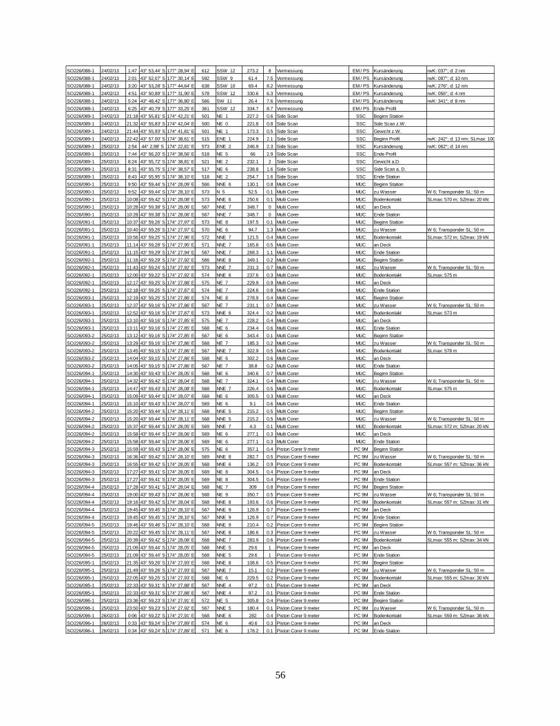
56
SO226/088-1 24/02/13 1:47 43° 53,44' S 177° 28,94' E 612 SSW 12 273.2 8 Vermessung EM / PS Kursänderung rwK: 037°; d: 2 nm
SO226/088-1 24/02/13 2:01 43° 52,07' S 177° 30,14' E 592 SSW 9 61.4 7.5 Vermessung EM / PS Kursänderung rwK: 097°; d: 10 nm
SO226/088-1 24/02/13 3:20 43° 53,28' S 177° 44,64' E 638 SSW 10 69.4 8.2 Vermessung EM / PS Kursänderung rwK: 276°; d: 12 nm
SO226/088-1 24/02/13 4:51 43° 50,89' S 177° 31,90' E 578 SSW 12 330.6 6.3 Vermessung EM / PS Kursänderung rwK: 056°; d: 4 nm
SO226/088-1 24/02/13 5:24 43° 48,42' S 177° 36,80' E 566 SW 11 26.4 7.6 Vermessung EM / PS Kursänderung rwK: 341°; d: 8 nm
SO226/088-1 24/02/13 6:25 43° 40,79' S 177° 33,25' E 361 SSW 12 334.7 8.7 Vermessung EM / PS Ende Profil
SO226/089-1 24/02/13 21:18 43° 55,81' S 174° 42,21' E 501 NE 1 227.2 0.6 Side Scan SSC Beginn Station
SO226/089-1 24/02/13 21:32 43° 55,83' S 174° 42,04' E 500 NE 0 221.8 0.8 Side Scan SSC Side Scan z.W.
SO226/089-1 24/02/13 21:44 43° 55,93' S 174° 41,81' E 501 NE 1 173.3 0.5 Side Scan SSC Gewicht z.W.
SO226/089-1 24/02/13 22:42 43° 57,00' S 174° 38,61' E 515 ENE 1 224.9 2.1 Side Scan SSC Beginn Profil rwK: 242°; d: 13 nm; SLmax: 1000 m
SO226/089-1 25/02/13 2:54 44° 2,98' S 174° 22,81' E 573 ENE 2 246.9 2.3 Side Scan SSC Kursänderung rwK: 062°; d: 14 nm
SO226/089-1 25/02/13 7:44 43° 56,20' S 174° 38,56' E 518 NE 5 66 2.9 Side Scan SSC Ende Profil
SO226/089-1 25/02/13 8:24 43° 55,72' S 174° 38,81' E 521 NE 2 232.1 2 Side Scan SSC Gewicht a.D.
SO226/089-1 25/02/13 8:31 43° 55,75' S 174° 38,57' E 517 NE 6 238.8 1.6 Side Scan SSC Side Scan a. D.
SO226/089-1 25/02/13 8:43 43° 55,95' S 174° 38,10' E 518 NE 2 254.7 1.6 Side Scan SSC Ende Station
SO226/090-1 25/02/13 9:50 43° 59,44' S 174° 28,09' E 566 NNE 6 130.1 0.8 Multi Corer MUC Beginn Station
SO226/090-1 25/02/13 9:52 43° 59,44' S 174° 28,10' E 573 N 5 52.5 0.1 Multi Corer MUC zu Wasser W 6; Transponder SL: 50 m
SO226/090-1 25/02/13 10:08 43° 59,42' S 174° 28,08' E 573 NNE 6 250.6 0.1 Multi Corer MUC Bodenkontakt SLmax: 570 m; SZmax: 20 kN
SO226/090-1 25/02/13 10:28 43° 59,38' S 174° 28,06' E 567 NNE 7 348.7 0 Multi Corer MUC an Deck
SO226/090-1 25/02/13 10:28 43° 59,38' S 174° 28,06' E 567 NNE 7 348.7 0 Multi Corer MUC Ende Station
SO226/091-1 25/02/13 10:37 43° 59,26' S 174° 27,97' E 573 NE 8 197.5 0.1 Multi Corer MUC Beginn Station
SO226/091-1 25/02/13 10:40 43° 59,26' S 174° 27,97' E 570 NE 6 94.7 1.3 Multi Corer MUC zu Wasser W 6; Transponder SL: 50 m
SO226/091-1 25/02/13 10:56 43° 59,25' S 174° 27,96' E 572 NNE 7 121.5 0.4 Multi Corer MUC Bodenkontakt SLmax: 572 m; SZmax: 19 kN
SO226/091-1 25/02/13 11:14 43° 59,28' S 174° 27,95' E 571 NNE 7 165.8 0.5 Multi Corer MUC an Deck
SO226/091-1 25/02/13 11:15 43° 59,29' S 174° 27,94' E 567 NNE 7 268.3 1.1 Multi Corer MUC Ende Station
SO226/092-1 25/02/13 11:16 43° 59,29' S 174° 27,92' E 566 NNE 8 349.1 0.2 Multi Corer MUC Beginn Station
SO226/092-1 25/02/13 11:43 43° 59,24' S 174° 27,92' E 573 NNE 7 231.3 0.7 Multi Corer MUC zu Wasser W 6; Transponder SL: 50 m
SO226/092-1 25/02/13 12:00 43° 59,22' S 174° 27,92' E 574 NNE 6 237.6 0.3 Multi Corer MUC Bodenkontakt SLmax: 575 m
SO226/092-1 25/02/13 12:17 43° 59,25' S 174° 27,88' E 575 NE 7 229.9 0.9 Multi Corer MUC an Deck
SO226/092-1 25/02/13 12:18 43° 59,25' S 174° 27,87' E 574 NE 7 224.6 0.8 Multi Corer MUC Ende Station
SO226/093-1 25/02/13 12:19 43° 59,25' S 174° 27,86' E 574 NE 8 278.9 0.4 Multi Corer MUC Beginn Station
SO226/093-1 25/02/13 12:37 43° 59,16' S 174° 27,86' E 567 NE 7 231.1 0.7 Multi Corer MUC zu Wasser W 6; Transponder SL: 50 m
SO226/093-1 25/02/13 12:52 43° 59,16' S 174° 27,87' E 573 NNE 6 324.4 0.2 Multi Corer MUC Bodenkontakt SLmax: 573 m
SO226/093-1 25/02/13 13:10 43° 59,16' S 174° 27,85' E 575 NE 7 228.2 0.4 Multi Corer MUC an Deck
SO226/093-1 25/02/13 13:11 43° 59,16' S 174° 27,85' E 568 NE 6 234.4 0.6 Multi Corer MUC Ende Station
SO226/093-2 25/02/13 13:12 43° 59,16' S 174° 27,85' E 567 NE 6 343.4 0.1 Multi Corer MUC Beginn Station
SO226/093-2 25/02/13 13:29 43° 59,16' S 174° 27,86' E 568 NE 7 185.3 0.2 Multi Corer MUC zu Wasser W 6; Transponder SL: 50 m
SO226/093-2 25/02/13 13:45 43° 59,15' S 174° 27,86' E 567 NNE 7 322.9 0.5 Multi Corer MUC Bodenkontakt SLmax: 578 m
SO226/093-2 25/02/13 14:04 43° 59,15' S 174° 27,86' E 568 NE 6 302.2 0.6 Multi Corer MUC an Deck
SO226/093-2 25/02/13 14:05 43° 59,15' S 174° 27,86' E 567 NE 7 38.8 0.2 Multi Corer MUC Ende Station
SO226/094-1 25/02/13 14:30 43° 59,43' S 174° 28,05' E 568 NE 6 340.6 0.7 Multi Corer MUC Beginn Station
SO226/094-1 25/02/13 14:32 43° 59,42' S 174° 28,04' E 568 NE 7 324.1 0.4 Multi Corer MUC zu Wasser W 6; Transponder SL: 50 m
SO226/094-1 25/02/13 14:47 43° 59,43' S 174° 28,08' E 568 NNE 7 226.4 0.5 Multi Corer MUC Bodenkontakt SLmax: 575 m
SO226/094-1 25/02/13 15:09 43° 59,44' S 174° 28,07' E 568 NE 6 305.5 0.3 Multi Corer MUC an Deck
SO226/094-1 25/02/13 15:10 43° 59,43' S 174° 28,07' E 569 NE 6 9.1 0.6 Multi Corer MUC Ende Station
SO226/094-2 25/02/13 15:20 43° 59,44' S 174° 28,11' E 568 NNE 5 215.2 0.5 Multi Corer MUC Beginn Station
SO226/094-2 25/02/13 15:20 43° 59,44' S 174° 28,11' E 568 NNE 5 215.2 0.5 Multi Corer MUC zu Wasser W 6; Transponder SL: 50 m
SO226/094-2 25/02/13 15:37 43° 59,44' S 174° 28,05' E 569 NNE 7 4.3 0.1 Multi Corer MUC Bodenkontakt SLmax: 572 m; SZmax: 20 kN
SO226/094-2 25/02/13 15:58 43° 59,44' S 174° 28,06' E 569 NE 6 277.1 0.3 Multi Corer MUC an Deck
SO226/094-2 25/02/13 15:58 43° 59,44' S 174° 28,06' E 569 NE 6 277.1 0.3 Multi Corer MUC Ende Station
SO226/094-3 25/02/13 15:59 43° 59,43' S 174° 28,06' E 575 NE 6 357.1 0.4 Piston Corer 9 meter PC 9M Beginn Station
SO226/094-3 25/02/13 16:36 43° 59,42' S 174° 28,10' E 569 NNE 8 282.7 0.5 Piston Corer 9 meter PC 9M zu Wasser W 6; Transponder SL: 50 m
SO226/094-3 25/02/13 16:55 43° 59,42' S 174° 28,05' E 568 NNE 6 136.2 0.9 Piston Corer 9 meter PC 9M Bodenkontakt SLmax: 557 m; SZmax: 36 kN
SO226/094-3 25/02/13 17:27 43° 59,41' S 174° 28,05' E 569 NE 8 304.5 0.4 Piston Corer 9 meter PC 9M an Deck
SO226/094-3 25/02/13 17:27 43° 59,41' S 174° 28,05' E 569 NE 8 304.5 0.4 Piston Corer 9 meter PC 9M Ende Station
SO226/094-4 25/02/13 17:28 43° 59,41' S 174° 28,04' E 568 NE 7 309 0.8 Piston Corer 9 meter PC 9M Beginn Station
SO226/094-4 25/02/13 19:00 43° 59,43' S 174° 28,06' E 568 NE 9 350.7 0.5 Piston Corer 9 meter PC 9M zu Wasser W 6; Transponder SL: 50 m
SO226/094-4 25/02/13 19:16 43° 59,42' S 174° 28,04' E 568 NNE 8 193.6 0.6 Piston Corer 9 meter PC 9M Bodenkontakt SLmax: 557 m; SZmax: 31 kN
SO226/094-4 25/02/13 19:45 43° 59,45' S 174° 28,10' E 567 NNE 9 126.9 0.7 Piston Corer 9 meter PC 9M an Deck
SO226/094-4 25/02/13 19:45 43° 59,45' S 174° 28,10' E 567 NNE 9 126.9 0.7 Piston Corer 9 meter PC 9M Ende Station
SO226/094-5 25/02/13 19:46 43° 59,46' S 174° 28,10' E 568 NNE 9 210.4 0.2 Piston Corer 9 meter PC 9M Beginn Station
SO226/094-5 25/02/13 20:22 43° 59,45' S 174° 28,11' E 567 NNE 8 186.6 0.3 Piston Corer 9 meter PC 9M zu Wasser W 6; Transponder SL: 50 m
SO226/094-5 25/02/13 20:39 43° 59,42' S 174° 28,08' E 568 NNE 7 283.9 0.6 Piston Corer 9 meter PC 9M Bodenkontakt SLmax: 555 m; SZmax: 34 kN
SO226/094-5 25/02/13 21:09 43° 59,44' S 174° 28,05' E 568 NNE 5 29.6 1 Piston Corer 9 meter PC 9M an Deck
SO226/094-5 25/02/13 21:09 43° 59,44' S 174° 28,05' E 568 NNE 5 29.6 1 Piston Corer 9 meter PC 9M Ende Station
SO226/095-1 25/02/13 21:35 43° 59,26' S 174° 27,93' E 568 NNE 8 108.6 0.5 Piston Corer 9 meter PC 9M Beginn Station
SO226/095-1 25/02/13 21:49 43° 59,26' S 174° 27,93' E 567 NNE 7 15.1 0.2 Piston Corer 9 meter PC 9M zu Wasser W 6; Transponder SL: 50 m
SO226/095-1 25/02/13 22:05 43° 59,25' S 174° 27,93' E 568 NE 6 229.5 0.2 Piston Corer 9 meter PC 9M Bodenkontakt SLmax: 555 m; SZmax: 30 kN
SO226/095-1 25/02/13 22:33 43° 59,31' S 174° 27,88' E 567 NNE 4 97.2 0.1 Piston Corer 9 meter PC 9M an Deck
SO226/095-1 25/02/13 22:33 43° 59,31' S 174° 27,88' E 567 NNE 4 97.2 0.1 Piston Corer 9 meter PC 9M Ende Station
SO226/096-1 25/02/13 23:36 43° 59,23' S 174° 27,91' E 572 NE 5 305.8 0.4 Piston Corer 9 meter PC 9M Beginn Station
SO226/096-1 25/02/13 23:50 43° 59,23' S 174° 27,92' E 567 NNE 5 180.4 0.1 Piston Corer 9 meter PC 9M zu Wasser W 6; Transponder SL: 50 m
SO226/096-1 26/02/13 0:06 43° 59,22' S 174° 27,91' E 568 NNE 6 282 0.4 Piston Corer 9 meter PC 9M Bodenkontakt SLmax: 559 m; SZmax: 36 kN
SO226/096-1 26/02/13 0:33 43° 59,24' S 174° 27,89' E 574 NE 6 40.6 0.3 Piston Corer 9 meter PC 9M an Deck
SO226/096-1 26/02/13 0:34 43° 59,24' S 174° 27,89' E 571 NE 6 178.2 0.1 Piston Corer 9 meter PC 9M Ende Station
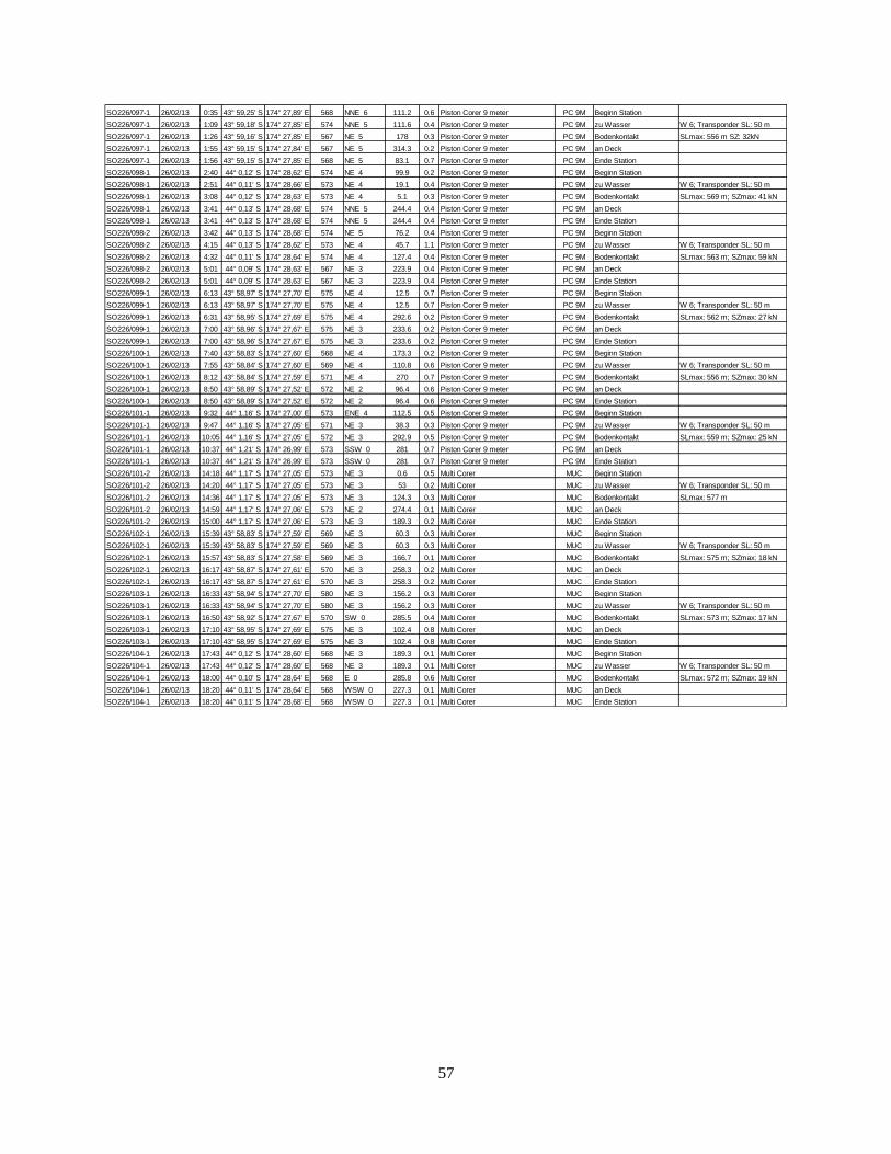
57
SO226/097-1 26/02/13 0:35 43° 59,25' S 174° 27,89' E 568 NNE 6 111.2 0.6 Piston Corer 9 meter PC 9M Beginn Station
SO226/097-1 26/02/13 1:09 43° 59,18' S 174° 27,85' E 574 NNE 5 111.6 0.4 Piston Corer 9 meter PC 9M zu Wasser W 6; Transponder SL: 50 m
SO226/097-1 26/02/13 1:26 43° 59,16' S 174° 27,85' E 567 NE 5 178 0.3 Piston Corer 9 meter PC 9M Bodenkontakt SLmax: 556 m SZ: 32kN
SO226/097-1 26/02/13 1:55 43° 59,15' S 174° 27,84' E 567 NE 5 314.3 0.2 Piston Corer 9 meter PC 9M an Deck
SO226/097-1 26/02/13 1:56 43° 59,15' S 174° 27,85' E 568 NE 5 83.1 0.7 Piston Corer 9 meter PC 9M Ende Station
SO226/098-1 26/02/13 2:40 44° 0,12' S 174° 28,62' E 574 NE 4 99.9 0.2 Piston Corer 9 meter PC 9M Beginn Station
SO226/098-1 26/02/13 2:51 44° 0,11' S 174° 28,66' E 573 NE 4 19.1 0.4 Piston Corer 9 meter PC 9M zu Wasser W 6; Transponder SL: 50 m
SO226/098-1 26/02/13 3:08 44° 0,12' S 174° 28,63' E 573 NE 4 5.1 0.3 Piston Corer 9 meter PC 9M Bodenkontakt SLmax: 569 m; SZmax: 41 kN
SO226/098-1 26/02/13 3:41 44° 0,13' S 174° 28,68' E 574 NNE 5 244.4 0.4 Piston Corer 9 meter PC 9M an Deck
SO226/098-1 26/02/13 3:41 44° 0,13' S 174° 28,68' E 574 NNE 5 244.4 0.4 Piston Corer 9 meter PC 9M Ende Station
SO226/098-2 26/02/13 3:42 44° 0,13' S 174° 28,68' E 574 NE 5 76.2 0.4 Piston Corer 9 meter PC 9M Beginn Station
SO226/098-2 26/02/13 4:15 44° 0,13' S 174° 28,62' E 573 NE 4 45.7 1.1 Piston Corer 9 meter PC 9M zu Wasser W 6; Transponder SL: 50 m
SO226/098-2 26/02/13 4:32 44° 0,11' S 174° 28,64' E 574 NE 4 127.4 0.4 Piston Corer 9 meter PC 9M Bodenkontakt SLmax: 563 m; SZmax: 59 kN
SO226/098-2 26/02/13 5:01 44° 0,09' S 174° 28,63' E 567 NE 3 223.9 0.4 Piston Corer 9 meter PC 9M an Deck
SO226/098-2 26/02/13 5:01 44° 0,09' S 174° 28,63' E 567 NE 3 223.9 0.4 Piston Corer 9 meter PC 9M Ende Station
SO226/099-1 26/02/13 6:13 43° 58,97' S 174° 27,70' E 575 NE 4 12.5 0.7 Piston Corer 9 meter PC 9M Beginn Station
SO226/099-1 26/02/13 6:13 43° 58,97' S 174° 27,70' E 575 NE 4 12.5 0.7 Piston Corer 9 meter PC 9M zu Wasser W 6; Transponder SL: 50 m
SO226/099-1 26/02/13 6:31 43° 58,95' S 174° 27,69' E 575 NE 4 292.6 0.2 Piston Corer 9 meter PC 9M Bodenkontakt SLmax: 562 m; SZmax: 27 kN
SO226/099-1 26/02/13 7:00 43° 58,96' S 174° 27,67' E 575 NE 3 233.6 0.2 Piston Corer 9 meter PC 9M an Deck
SO226/099-1 26/02/13 7:00 43° 58,96' S 174° 27,67' E 575 NE 3 233.6 0.2 Piston Corer 9 meter PC 9M Ende Station
SO226/100-1 26/02/13 7:40 43° 58,83' S 174° 27,60' E 568 NE 4 173.3 0.2 Piston Corer 9 meter PC 9M Beginn Station
SO226/100-1 26/02/13 7:55 43° 58,84' S 174° 27,60' E 569 NE 4 110.8 0.6 Piston Corer 9 meter PC 9M zu Wasser W 6; Transponder SL: 50 m
SO226/100-1 26/02/13 8:12 43° 58,84' S 174° 27,59' E 571 NE 4 270 0.7 Piston Corer 9 meter PC 9M Bodenkontakt SLmax: 556 m; SZmax: 30 kN
SO226/100-1 26/02/13 8:50 43° 58,89' S 174° 27,52' E 572 NE 2 96.4 0.6 Piston Corer 9 meter PC 9M an Deck
SO226/100-1 26/02/13 8:50 43° 58,89' S 174° 27,52' E 572 NE 2 96.4 0.6 Piston Corer 9 meter PC 9M Ende Station
SO226/101-1 26/02/13 9:32 44° 1,16' S 174° 27,00' E 573 ENE 4 112.5 0.5 Piston Corer 9 meter PC 9M Beginn Station
SO226/101-1 26/02/13 9:47 44° 1,16' S 174° 27,05' E 571 NE 3 38.3 0.3 Piston Corer 9 meter PC 9M zu Wasser W 6; Transponder SL: 50 m
SO226/101-1 26/02/13 10:05 44° 1,16' S 174° 27,05' E 572 NE 3 292.9 0.5 Piston Corer 9 meter PC 9M Bodenkontakt SLmax: 559 m; SZmax: 25 kN
SO226/101-1 26/02/13 10:37 44° 1,21' S 174° 26,99' E 573 SSW 0 281 0.7 Piston Corer 9 meter PC 9M an Deck
SO226/101-1 26/02/13 10:37 44° 1,21' S 174° 26,99' E 573 SSW 0 281 0.7 Piston Corer 9 meter PC 9M Ende Station
SO226/101-2 26/02/13 14:18 44° 1,17' S 174° 27,05' E 573 NE 3 0.6 0.5 Multi Corer MUC Beginn Station
SO226/101-2 26/02/13 14:20 44° 1,17' S 174° 27,05' E 573 NE 3 53 0.2 Multi Corer MUC zu Wasser W 6; Transponder SL: 50 m
SO226/101-2 26/02/13 14:36 44° 1,17' S 174° 27,05' E 573 NE 3 124.3 0.3 Multi Corer MUC Bodenkontakt SLmax: 577 m
SO226/101-2 26/02/13 14:59 44° 1,17' S 174° 27,06' E 573 NE 2 274.4 0.1 Multi Corer MUC an Deck
SO226/101-2 26/02/13 15:00 44° 1,17' S 174° 27,06' E 573 NE 3 189.3 0.2 Multi Corer MUC Ende Station
SO226/102-1 26/02/13 15:39 43° 58,83' S 174° 27,59' E 569 NE 3 60.3 0.3 Multi Corer MUC Beginn Station
SO226/102-1 26/02/13 15:39 43° 58,83' S 174° 27,59' E 569 NE 3 60.3 0.3 Multi Corer MUC zu Wasser W 6; Transponder SL: 50 m
SO226/102-1 26/02/13 15:57 43° 58,83' S 174° 27,58' E 569 NE 3 166.7 0.1 Multi Corer MUC Bodenkontakt SLmax: 575 m; SZmax: 18 kN
SO226/102-1 26/02/13 16:17 43° 58,87' S 174° 27,61' E 570 NE 3 258.3 0.2 Multi Corer MUC an Deck
SO226/102-1 26/02/13 16:17 43° 58,87' S 174° 27,61' E 570 NE 3 258.3 0.2 Multi Corer MUC Ende Station
SO226/103-1 26/02/13 16:33 43° 58,94' S 174° 27,70' E 580 NE 3 156.2 0.3 Multi Corer MUC Beginn Station
SO226/103-1 26/02/13 16:33 43° 58,94' S 174° 27,70' E 580 NE 3 156.2 0.3 Multi Corer MUC zu Wasser W 6; Transponder SL: 50 m
SO226/103-1 26/02/13 16:50 43° 58,92' S 174° 27,67' E 570 SW 0 285.5 0.4 Multi Corer MUC Bodenkontakt SLmax: 573 m; SZmax: 17 kN
SO226/103-1 26/02/13 17:10 43° 58,95' S 174° 27,69' E 575 NE 3 102.4 0.8 Multi Corer MUC an Deck
SO226/103-1 26/02/13 17:10 43° 58,95' S 174° 27,69' E 575 NE 3 102.4 0.8 Multi Corer MUC Ende Station
SO226/104-1 26/02/13 17:43 44° 0,12' S 174° 28,60' E 568 NE 3 189.3 0.1 Multi Corer MUC Beginn Station
SO226/104-1 26/02/13 17:43 44° 0,12' S 174° 28,60' E 568 NE 3 189.3 0.1 Multi Corer MUC zu Wasser W 6; Transponder SL: 50 m
SO226/104-1 26/02/13 18:00 44° 0,10' S 174° 28,64' E 568 E 0 285.8 0.6 Multi Corer MUC Bodenkontakt SLmax: 572 m; SZmax: 19 kN
SO226/104-1 26/02/13 18:20 44° 0,11' S 174° 28,64' E 568 WSW 0 227.3 0.1 Multi Corer MUC an Deck
SO226/104-1 26/02/13 18:20 44° 0,11' S 174° 28,68' E 568 WSW 0 227.3 0.1 Multi Corer MUC Ende Station

58
Appendix 3: Sediment Porewater Data, each page represents a single core.
SO226/2-30-2-PC9
Core Sample ID
Sample
Depth
(cmbsf)
Cl-
(mM)
SO42-
(mM)
DIC
(mM)
CH4
(ppm)
30-2-PC9 1 10 569.9 30.1 2.27 BLD
30-2-PC9 2 20 614.5 32.4 2.37 BLD
30-2-PC9 3 40 585.2 30.9 2.41 BLD
30-2-PC9 4 60 572.4 30.1 2.47 BLD
30-2-PC9 5 80 645.6 34.4 2.52 BLD
30-2-PC9 6 100 558.6 29.5 2.92 BLD
30-2-PC9 7 120 599.7 31.4 2.83 BLD
30-2-PC9 8 150 570.3 29.8 2.56 BLD
30-2-PC9 9 185 734.9 39.3 2.93 BLD
30-2-PC9 10 215 536.0 28.0 2.62 BLD
30-2-PC9 11 250 617.2 32.4 2.86 0.09
30-2-PC9 12 290 634.9 33.9 2.90 0.44
30-2-PC9 13 330 590.8 31.3 2.93 0.49
30-2-PC9 14 370 588.7 30.7 2.99 0.23
30-2-PC9 15 405 513.8 26.1 2.97 0.52
30-2-PC9 16 435 517.2 26.2 2.95 0.47
30-2-PC9 17 470 520.1 26.6 2.73 0.46
30-2-PC9 18 505 601.6 31.7 2.99 BLD
30-2-PC9 19 540 553.2 29.3 3.01 0.67
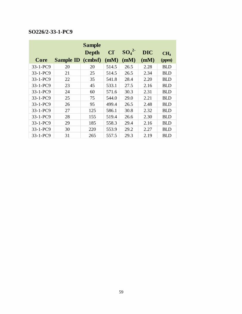
59
SO226/2-33-1-PC9
Core Sample ID
Sample
Depth
(cmbsf)
Cl-
(mM)
SO42-
(mM)
DIC
(mM)
CH4
(ppm)
33-1-PC9 20 20 514.5 26.5 2.28 BLD
33-1-PC9 21 25 514.5 26.5 2.34 BLD
33-1-PC9 22 35 541.8 28.4 2.20 BLD
33-1-PC9 23 45 533.1 27.5 2.16 BLD
33-1-PC9 24 60 571.6 30.3 2.31 BLD
33-1-PC9 25 75 544.0 29.0 2.21 BLD
33-1-PC9 26 95 499.4 26.5 2.48 BLD
33-1-PC9 27 125 586.1 30.8 2.32 BLD
33-1-PC9 28 155 519.4 26.6 2.30 BLD
33-1-PC9 29 185 558.3 29.4 2.16 BLD
33-1-PC9 30 220 553.9 29.2 2.27 BLD
33-1-PC9 31 265 557.5 29.3 2.19 BLD

60
SO226/2-44-2-PC9
Core Sample ID
Sample
Depth
(cmbsf)
Cl-
(mM)
SO42-
(mM)
DIC
(mM)
CH4
(ppm)
44-1-PC9 32 10 531.6 28.4 2.38 BLD
44-1-PC9 33 25 529.2 28.3 2.43 BLD
44-1-PC9 34 45 526.1 28.1 2.20 BLD
44-1-PC9 35 65 528.1 28.2 2.49 BLD
44-1-PC9 36 85 607.5 32.3 2.53 BLD
44-1-PC9 37 105 531.6 28.3 2.55 BLD
44-1-PC9 38 125 482.4 25.7 2.46 BLD
44-1-PC9 39 155 541.8 28.0 2.52 BLD
44-1-PC9 40 185 543.3 27.9 2.57 BLD
44-1-PC9 41 215 545.5 28.1 2.69 BLD
44-1-PC9 42 245 537.2 27.9 2.55 BLD
44-1-PC9 43 285 576.1 30.4 2.68 BLD
44-1-PC9 44 315 561.0 29.3 2.87 BLD
44-1-PC9 45 345 527.6 27.1 2.36 BLD
44-1-PC9 46 375 541.2 27.7 2.66 BLD
44-1-PC9 47 405 531.6 27.6 2.63 BLD
44-1-PC9 48 435 536.2 27.4 2.71 BLD
44-1-PC9 49 470 534.9 27.3 2.53 BLD
44-1-PC9 50 510 532.5 27.3 2.33 BLD
44-1-PC9 51 545 540.9 27.7 2.75 BLD
44-1-PC9 52 575 532.3 27.5 2.96 BLD
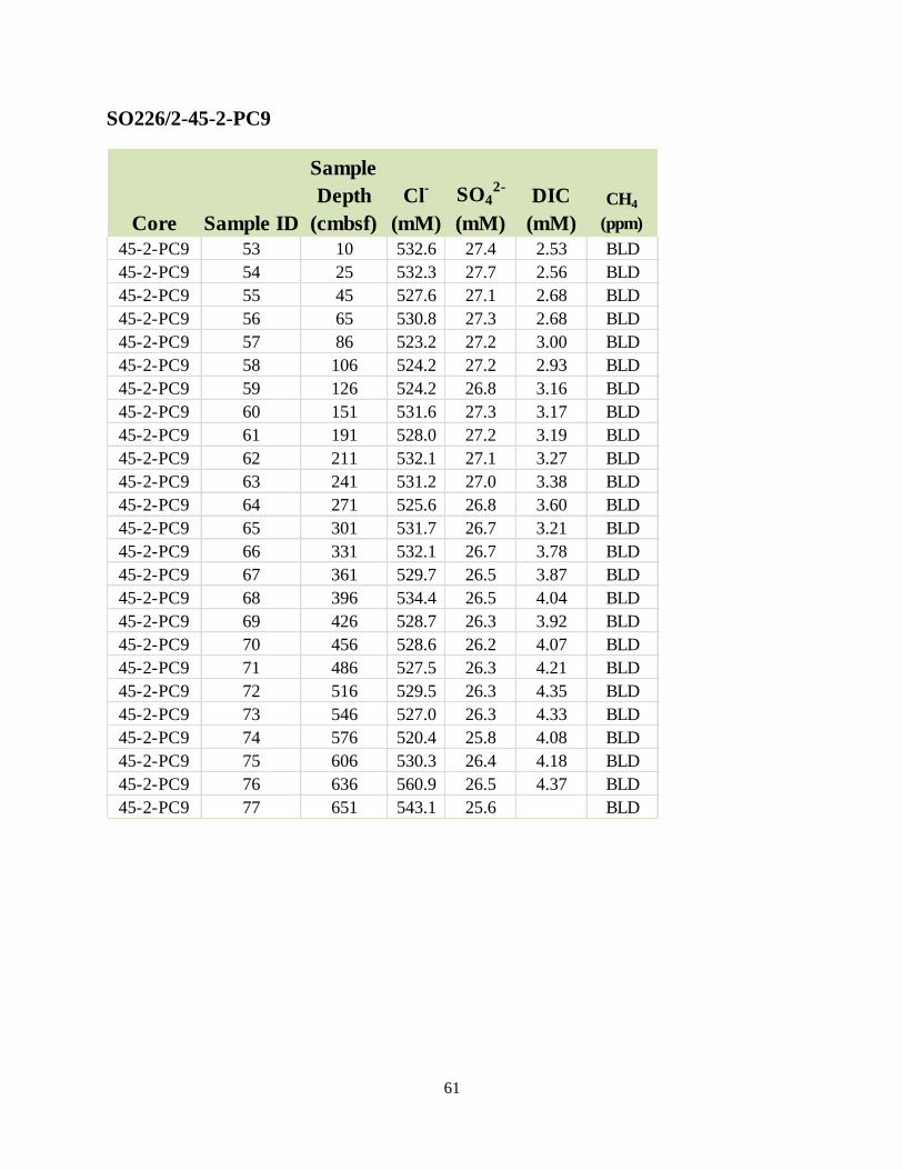
61
SO226/2-45-2-PC9
Core Sample ID
Sample
Depth
(cmbsf)
Cl-
(mM)
SO42-
(mM)
DIC
(mM)
CH4
(ppm)
45-2-PC9 53 10 532.6 27.4 2.53 BLD
45-2-PC9 54 25 532.3 27.7 2.56 BLD
45-2-PC9 55 45 527.6 27.1 2.68 BLD
45-2-PC9 56 65 530.8 27.3 2.68 BLD
45-2-PC9 57 86 523.2 27.2 3.00 BLD
45-2-PC9 58 106 524.2 27.2 2.93 BLD
45-2-PC9 59 126 524.2 26.8 3.16 BLD
45-2-PC9 60 151 531.6 27.3 3.17 BLD
45-2-PC9 61 191 528.0 27.2 3.19 BLD
45-2-PC9 62 211 532.1 27.1 3.27 BLD
45-2-PC9 63 241 531.2 27.0 3.38 BLD
45-2-PC9 64 271 525.6 26.8 3.60 BLD
45-2-PC9 65 301 531.7 26.7 3.21 BLD
45-2-PC9 66 331 532.1 26.7 3.78 BLD
45-2-PC9 67 361 529.7 26.5 3.87 BLD
45-2-PC9 68 396 534.4 26.5 4.04 BLD
45-2-PC9 69 426 528.7 26.3 3.92 BLD
45-2-PC9 70 456 528.6 26.2 4.07 BLD
45-2-PC9 71 486 527.5 26.3 4.21 BLD
45-2-PC9 72 516 529.5 26.3 4.35 BLD
45-2-PC9 73 546 527.0 26.3 4.33 BLD
45-2-PC9 74 576 520.4 25.8 4.08 BLD
45-2-PC9 75 606 530.3 26.4 4.18 BLD
45-2-PC9 76 636 560.9 26.5 4.37 BLD
45-2-PC9 77 651 543.1 25.6 BLD

62
SO226/2-51-2-PC9
Core Sample ID
Sample
Depth
(cmbsf)
Cl-
(mM)
SO42-
(mM)
DIC
(mM)
CH4
(ppm)
51-2-PC9 78 10 536.2 27.6 2.47 BLD
51-2-PC9 79 25 530.9 27.4 ND BLD
51-2-PC9 80 35 527.5 27.1 2.54 BLD
51-2-PC9 81 45 538.3 27.7 2.54 BLD
51-2-PC9 82 58 530.1 27.4 2.48 BLD
51-2-PC9 83 68 532.2 27.5 2.57 BLD
51-2-PC9 84 78 517.7 26.8 2.56 BLD
51-2-PC9 85 98 ND 29.2 2.68 BLD
51-2-PC9 86 118 464.6 23.9 2.69 BLD
51-2-PC9 87 138 464.0 24.0 2.85 BLD
51-2-PC9 88 168 458.9 23.5 2.92 BLD
51-2-PC9 89 198 459.0 23.6 2.85 BLD
51-2-PC9 90 233 451.1 23.3 3.09 BLD
51-2-PC9 91 273 458.7 23.5 2.91 BLD
51-2-PC9 92 313 469.5 24.0 3.15 BLD
51-2-PC9 93 348 460.7 23.5 3.31 BLD
51-2-PC9 94 379 460.2 23.5 3.19 BLD
51-2-PC9 95 419 450.7 22.9 3.27 BLD
51-2-PC9 96 459 520.1 26.3 3.14 BLD
51-2-PC9 97 499 482.5 24.6 3.14 BLD
51-2-PC9 98 539 464.9 23.6 3.33 BLD
51-2-PC9 99 579 457.4 23.1 3.39 BLD
51-2-PC9 100 624 458.7 23.4 3.50 BLD

63
SO226/2-52-2-PC9
Core Sample ID
Sample
Depth
(cmbsf)
Cl-
(mM)
SO42-
(mM)
DIC
(mM)
CH4
(ppm)
52-1-PC9 101 10 ND 28.8 2.67 0.16
52-1-PC9 102 25 528.5 27.4 3.16 0.19
52-1-PC9 103 35 522.0 26.7 2.55 0.23
52-1-PC9 104 52 533.0 27.4 2.60 0.31
52-1-PC9 105 62 523.8 26.8 2.62 0.41
52-1-PC9 106 72 526.0 27.1 2.47 0.31
52-1-PC9 107 87 525.1 26.8 2.62 0.40
52-1-PC9 108 107 534.5 27.2 2.98 0.46
52-1-PC9 109 127 529.5 27.2 3.03 0.49
52-1-PC9 110 147 528.6 26.8 2.90 0.65
52-1-PC9 111 167 512.9 26.4 3.31 0.67
52-1-PC9 112 192 536.2 27.2 3.40 0.69
52-1-PC9 113 222 538.7 27.0 3.54 0.79
52-1-PC9 114 257 519.2 26.3 3.95 BLD
52-1-PC9 115 297 525.3 25.9 3.75 0.72
52-1-PC9 116 337 517.1 25.7 3.97 0.87
52-1-PC9 117 372 530.7 26.4 3.99 BLD
52-1-PC9 118 412 542.5 26.6 4.24 1.16
52-1-PC9 119 452 535.7 26.2 4.13 1.16
52-1-PC9 120 492 535.6 26.2 4.26 1.12
52-1-PC9 121 532 513.4 25.2 4.34 BLD
52-1-PC9 122 572 527.7 25.8 4.19 1.05
52-1-PC9 123 622 533.7 26.2 4.44 1.15
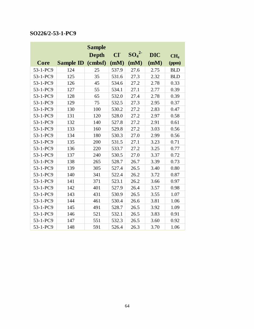
64
SO226/2-53-1-PC9
Core Sample ID
Sample
Depth
(cmbsf)
Cl-
(mM)
SO42-
(mM)
DIC
(mM)
CH4
(ppm)
53-1-PC9 124 25 537.9 27.6 2.75 BLD
53-1-PC9 125 35 531.6 27.3 2.32 BLD
53-1-PC9 126 45 534.6 27.2 2.78 0.33
53-1-PC9 127 55 534.1 27.1 2.77 0.39
53-1-PC9 128 65 532.0 27.4 2.78 0.39
53-1-PC9 129 75 532.5 27.3 2.95 0.37
53-1-PC9 130 100 530.2 27.2 2.83 0.47
53-1-PC9 131 120 528.0 27.2 2.97 0.58
53-1-PC9 132 140 527.8 27.2 2.91 0.61
53-1-PC9 133 160 529.8 27.2 3.03 0.56
53-1-PC9 134 180 530.3 27.0 2.99 0.56
53-1-PC9 135 200 531.5 27.1 3.23 0.71
53-1-PC9 136 220 533.7 27.2 3.25 0.77
53-1-PC9 137 240 530.5 27.0 3.37 0.72
53-1-PC9 138 265 528.7 26.7 3.39 0.73
53-1-PC9 139 305 527.4 26.5 3.40 0.80
53-1-PC9 140 341 522.4 26.2 3.72 0.87
53-1-PC9 141 371 523.1 26.2 3.66 0.97
53-1-PC9 142 401 527.9 26.4 3.57 0.98
53-1-PC9 143 431 530.9 26.5 3.55 1.07
53-1-PC9 144 461 530.4 26.6 3.81 1.06
53-1-PC9 145 491 528.7 26.5 3.92 1.09
53-1-PC9 146 521 532.1 26.5 3.83 0.91
53-1-PC9 147 551 532.3 26.5 3.60 0.92
53-1-PC9 148 591 526.4 26.3 3.70 1.06

65
SO226/2-54-1-PC9
Core Sample ID
Sample
Depth
(cmbsf)
Cl-
(mM)
SO42-
(mM)
DIC
(mM)
CH4
(ppm)
54-1-PC9 149 5 525.3 27.0 2.19 0.23
54-1-PC9 150 25 527.3 26.7 2.68 0.29
54-1-PC9 151 35 530.4 27.0 2.83 0.32
54-1-PC9 152 45 527.0 26.8 2.76 0.34
54-1-PC9 153 55 529.3 26.9 3.04 0.55
54-1-PC9 154 76 523.5 26.8 3.01 0.52
54-1-PC9 155 106 526.4 26.8 3.08 0.52
54-1-PC9 156 116 530.5 26.7 3.25 0.55
54-1-PC9 157 136 525.2 26.4 3.37 0.63
54-1-PC9 158 156 528.0 26.7 3.48 0.73
54-1-PC9 159 181 524.5 26.5 ND 0.77
54-1-PC9 160 211 529.0 26.5 3.80 0.70
54-1-PC9 161 241 527.8 26.0 3.86 0.81
54-1-PC9 162 271 525.2 25.9 3.98 0.96
54-1-PC9 163 301 531.2 26.2 4.04 1.02
54-1-PC9 164 331 520.8 25.4 4.24 1.14
54-1-PC9 165 356 529.0 26.1 ND 1.15
54-1-PC9 166 386 528.9 25.8 4.21 0.97
54-1-PC9 167 416 532.0 26.0 4.29 1.01
54-1-PC9 168 446 529.2 25.8 4.62 0.96
54-1-PC9 169 476 531.6 26.1 4.26 1.02
54-1-PC9 170 506 525.9 25.6 4.52 1.10
54-1-PC9 171 536 530.3 25.8 4.85 1.12
54-1-PC9 172 566 534.1 25.9 4.75 1.23
54-1-PC9 173 596 526.6 25.4 4.67 1.25
54-1-PC9 174 621 535.8 25.9 4.74 1.38
54-1-PC9 175 646 533.3 25.8 5.29 1.27
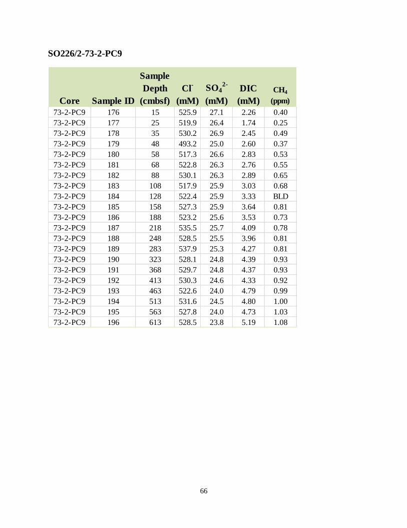
66
SO226/2-73-2-PC9
Core Sample ID
Sample
Depth
(cmbsf)
Cl-
(mM)
SO42-
(mM)
DIC
(mM)
CH4
(ppm)
73-2-PC9 176 15 525.9 27.1 2.26 0.40
73-2-PC9 177 25 519.9 26.4 1.74 0.25
73-2-PC9 178 35 530.2 26.9 2.45 0.49
73-2-PC9 179 48 493.2 25.0 2.60 0.37
73-2-PC9 180 58 517.3 26.6 2.83 0.53
73-2-PC9 181 68 522.8 26.3 2.76 0.55
73-2-PC9 182 88 530.1 26.3 2.89 0.65
73-2-PC9 183 108 517.9 25.9 3.03 0.68
73-2-PC9 184 128 522.4 25.9 3.33 BLD
73-2-PC9 185 158 527.3 25.9 3.64 0.81
73-2-PC9 186 188 523.2 25.6 3.53 0.73
73-2-PC9 187 218 535.5 25.7 4.09 0.78
73-2-PC9 188 248 528.5 25.5 3.96 0.81
73-2-PC9 189 283 537.9 25.3 4.27 0.81
73-2-PC9 190 323 528.1 24.8 4.39 0.93
73-2-PC9 191 368 529.7 24.8 4.37 0.93
73-2-PC9 192 413 530.3 24.6 4.33 0.92
73-2-PC9 193 463 522.6 24.0 4.79 0.99
73-2-PC9 194 513 531.6 24.5 4.80 1.00
73-2-PC9 195 563 527.8 24.0 4.73 1.03
73-2-PC9 196 613 528.5 23.8 5.19 1.08

67
SO226/2-74-1-PC9
Core Sample ID
Sample
Depth
(cmbsf)
Cl-
(mM)
SO42-
(mM)
DIC
(mM)
CH4
(ppm)
74-1-PC9 197 17 540.1 27.6 2.39 0.34
74-1-PC9 198 27 523.3 26.8 2.42 0.12
74-1-PC9 199 37 521.5 26.7 2.87 0.64
74-1-PC9 200 47 531.7 26.8 2.35 0.45
74-1-PC9 201 57 529.4 26.8 1.30 0.46
74-1-PC9 202 72 529.7 26.8 1.60 0.41
74-1-PC9 203 87 532.3 27.0 2.97 0.19
74-1-PC9 204 107 521.4 26.5 2.93 0.63
74-1-PC9 205 132 528.0 26.5 3.31 0.55
74-1-PC9 206 152 521.2 26.4 3.34 0.62
74-1-PC9 207 172 524.7 26.4 3.12 0.68
74-1-PC9 208 192 524.7 26.2 3.32 0.67
74-1-PC9 209 217 489.7 24.5 3.30 0.70
74-1-PC9 210 247 514.4 25.7 3.24 0.70
74-1-PC9 211 277 522.1 26.1 5.24 0.37
74-1-PC9 212 297 519.1 26.1 3.84 0.80
74-1-PC9 213 332 536.2 26.3 3.65 0.81
74-1-PC9 214 367 523.9 25.9 4.00 0.88
74-1-PC9 215 407 523.5 25.8 4.10 0.93
74-1-PC9 216 447 517.6 25.4 4.13 0.78
74-1-PC9 217 487 517.7 25.4 3.33 0.90
74-1-PC9 218 527 537.0 26.0 4.05 0.96
74-1-PC9 219 562 514.8 24.8 2.82 0.64
74-1-PC9 220 592 520.6 25.0 4.31 0.82

68
SO226/2-75-2-PC9
Core Sample ID
Sample
Depth
(cmbsf)
Cl-
(mM)
SO42-
(mM)
DIC
(mM)
CH4
(ppm)
75-2-PC9 221 5 532.7 27.4 2.22 0.19
75-2-PC9 222 25 529.7 26.9 3.87 0.27
75-2-PC9 223 35 522.0 26.4 2.60 0.29
75-2-PC9 224 45 524.4 26.4 ND BLD
75-2-PC9 225 64 526.6 26.2 ND 0.40
75-2-PC9 226 74 531.2 26.3 3.44 0.19
75-2-PC9 227 84 527.9 26.0 3.53 0.42
75-2-PC9 228 94 528.0 25.8 3.62 0.51
75-2-PC9 229 104 522.5 25.5 3.99 0.38
75-2-PC9 230 114 532.0 25.8 3.94 0.52
75-2-PC9 231 124 534.4 25.8 4.08 0.49
75-2-PC9 232 144 525.5 25.1 4.43 0.61
75-2-PC9 233 164 535.4 25.4 4.67 0.63
75-2-PC9 234 184 530.1 24.7 5.44 0.66
75-2-PC9 235 204 535.3 24.7 5.24 0.79
75-2-PC9 236 224 525.4 24.0 5.48 0.79
75-2-PC9 237 249 525.9 23.6 5.97 0.92
75-2-PC9 238 284 531.3 23.2 6.26 0.95
75-2-PC9 239 314 530.7 22.6 7.11 1.01
75-2-PC9 240 344 526.0 21.8 8.12 1.01
75-2-PC9 241 380 529.6 21.2 8.35 1.07
75-2-PC9 242 415 527.0 20.7 8.67 1.16
75-2-PC9 243 455 525.8 20.0 9.58 1.08
75-2-PC9 244 495 515.1 18.9 9.70 1.16
75-2-PC9 245 535 507.2 17.9 10.45 1.23
75-2-PC9 246 575 517.6 17.5 10.71 1.23
75-2-PC9 247 620 529.9 17.1 12.13 1.18

69
SO226/2-76-1-PC9
Core Sample ID
Sample
Depth
(cmbsf)
Cl-
(mM)
SO42-
(mM)
DIC
(mM)
CH4
(ppm)
76-1-PC9 248 5 519.2 26.9 1.23 0.02
76-1-PC9 249 15 512.8 26.4 1.53 0.12
76-1-PC9 250 25 519.7 26.8 1.53 0.24
76-1-PC9 251 58 524.5 26.8 2.35 0.23
76-1-PC9 252 68 522.2 26.5 2.92 0.25
76-1-PC9 253 88 525.1 26.6 2.36 0.29
76-1-PC9 254 108 522.3 26.3 ND 0.35
76-1-PC9 255 128 520.8 26.1 ND 0.24
76-1-PC9 256 148 520.1 25.9 3.53 0.39
76-1-PC9 257 168 519.8 25.8 3.49 0.47
76-1-PC9 258 193 524.1 25.9 3.55 0.44
76-1-PC9 259 213 524.4 25.9 3.59 0.55
76-1-PC9 260 233 524.3 25.6 4.12 0.50
76-1-PC9 261 263 520.4 25.2 3.96 0.55
76-1-PC9 262 293 525.4 25.2 4.40 0.55
76-1-PC9 263 323 517.4 24.6 7.03 0.55
76-1-PC9 264 363 523.1 24.7 4.91 0.64
76-1-PC9 265 388 526.2 24.7 4.81 0.65
76-1-PC9 266 423 525.9 24.6 5.02 0.80
76-1-PC9 267 458 527.3 24.5 4.89 0.68
76-1-PC9 268 498 526.4 24.3 5.26 0.84
76-1-PC9 269 538 523.0 24.0 5.45 BLD
76-1-PC9 270 578 522.5 24.1 4.74 0.70
76-1-PC9 271 623 520.3 23.8 5.11 0.61

70
SO226/2-77-2-PC9
Core Sample ID
Sample
Depth
(cmbsf)
Cl-
(mM)
SO42-
(mM)
DIC
(mM)
CH4
(ppm)
77-2-PC9 272 5 529.1 27.3 ND 0.01
77-2-PC9 273 15 506.4 26.1 ND 0.06
77-2-PC9 274 28 532.0 27.3 ND 0.05
77-2-PC9 275 38 513.6 26.2 3.14 BLD
77-2-PC9 276 48 509.5 26.2 2.63 0.18
77-2-PC9 277 68 523.8 26.5 2.84 0.25
77-2-PC9 278 88 525.8 26.4 2.71 0.34
77-2-PC9 279 108 525.9 26.2 3.11 0.29
77-2-PC9 280 128 520.7 25.8 2.93 0.41
77-2-PC9 281 148 514.9 25.4 ND 0.40
77-2-PC9 282 173 515.5 25.3 3.28 0.37
77-2-PC9 283 208 514.3 25.0 3.59 0.50
77-2-PC9 284 238 506.2 24.2 4.75 0.51
77-2-PC9 285 268 520.7 24.8 4.06 0.58
77-2-PC9 286 303 526.8 24.7 4.41 0.70
77-2-PC9 287 343 522.9 24.4 4.31 0.76
77-2-PC9 288 373 524.0 24.3 4.19 0.73
77-2-PC9 289 403 524.3 24.1 4.06 0.81
77-2-PC9 290 438 523.3 24.0 4.52 0.92
77-2-PC9 291 478 511.2 23.2 4.66 0.88
77-2-PC9 292 518 519.1 23.4 4.47 1.02
77-2-PC9 293 558 517.7 23.1 5.11 1.06
77-2-PC9 294 603 520.2 23.1 4.85 0.80

71
SO226/2-82-3-PC9
Core Sample ID
Sample
Depth
(cmbsf)
Cl-
(mM)
SO42-
(mM)
DIC
(mM)
CH4
(ppm)
82-3-PC9 295 25 516.2 26.6 2.29 0.06
82-3-PC9 296 35 517.7 26.6 2.43 0.22
82-3-PC9 297 45 521.2 26.9 2.22 0.11
82-3-PC9 298 55 520.8 26.8 2.38 0.12
82-3-PC9 299 65 523.0 26.9 2.35 0.10
82-3-PC9 300 75 520.5 26.8 2.31 0.10
82-3-PC9 301 90 507.9 26.2 2.43 0.09
82-3-PC9 302 110 522.2 26.9 2.36 0.16
82-3-PC9 303 130 521.6 26.8 2.46 0.17
82-3-PC9 304 150 514.9 26.5 2.55 0.12
82-3-PC9 305 170 525.9 27.1 2.50 0.16
82-3-PC9 306 190 523.6 26.9 2.52 0.16
82-3-PC9 307 210 527.5 27.1 2.33 0.16
82-3-PC9 308 230 525.0 26.8 2.61 0.17
82-3-PC9 309 250 525.1 27.0 2.86 0.22
82-3-PC9 310 270 523.3 26.7 2.85 0.29
82-3-PC9 311 290 525.6 26.5 3.40 0.35
82-3-PC9 312 310 520.9 26.3 3.15 0.43
82-3-PC9 313 340 522.8 26.1 3.56 0.48
82-3-PC9 314 370 524.0 25.8 4.16 0.54
82-3-PC9 315 400 520.9 25.1 4.27 0.63
82-3-PC9 316 430 513.2 24.3 4.96 0.72
82-3-PC9 317 460 507.3 23.6 5.50 0.70
82-3-PC9 318 500 525.3 23.8 6.11 0.78
82-3-PC9 319 550 517.7 22.9 5.70 0.82
82-3-PC9 320 600 528.9 22.9 ND BLD

72
SO226/2-83-1-PC9
Core Sample ID
Sample
Depth
(cmbsf)
Cl-
(mM)
SO42-
(mM)
DIC
(mM)
CH4
(ppm)
83-1-PC9 321 5 508.6 26.2 1.88 0.19
83-1-PC9 322 20 517.6 26.7 1.80 0.21
83-1-PC9 323 35 509.8 26.3 2.07 0.19
83-1-PC9 324 45 513.7 26.4 2.28 0.14
83-1-PC9 325 55 522.4 26.8 2.24 0.12
83-1-PC9 326 75 517.0 26.6 2.45 BLD
83-1-PC9 327 95 515.2 26.5 2.45 0.26
83-1-PC9 328 115 518.2 26.6 2.43 0.30
83-1-PC9 329 140 523.8 26.8 2.54 0.32
83-1-PC9 330 155 513.0 26.4 2.41 0.25
83-1-PC9 331 165 508.0 26.1 2.59 0.32
83-1-PC9 332 175 511.6 26.2 2.49 0.29
83-1-PC9 333 185 519.9 26.7 2.59 0.21
83-1-PC9 334 195 522.4 26.7 2.58 0.23
83-1-PC9 335 205 522.7 26.8 2.63 0.30
83-1-PC9 336 215 521.0 26.6 2.67 0.31
83-1-PC9 337 240 518.7 26.4 2.76 0.33
83-1-PC9 338 265 523.0 26.7 2.76 0.37
83-1-PC9 339 285 525.5 26.6 2.91 0.32
83-1-PC9 340 315 513.8 25.7 2.91 0.34
83-1-PC9 341 355 520.3 25.9 3.32 0.39
83-1-PC9 342 395 517.7 25.7 3.24 0.44
83-1-PC9 343 435 490.8 24.5 3.64 0.43
83-1-PC9 344 475 518.7 25.7 3.71 0.58
83-1-PC9 345 515 517.3 25.4 3.75 0.56
83-1-PC9 346 555 511.7 25.0 3.98 0.63
83-1-PC9 347 595 514.6 25.0 4.26 0.65
83-1-PC9 348 620 484.8 23.5 4.11 0.65

73
SO226/2-84-1-PC9
Core Sample ID
Sample
Depth
(cmbsf)
Cl-
(mM)
SO42-
(mM)
DIC
(mM)
CH4
(ppm)
84-1-PC9 349 10 506.4 26.1 2.54 0.13
84-1-PC9 350 25 519.8 26.7 2.50 0.10
84-1-PC9 351 45 513.5 26.4 2.27 0.17
84-1-PC9 352 62 523.4 27.0 2.56 0.15
84-1-PC9 353 87 517.8 26.6 2.30 0.19
84-1-PC9 354 107 522.7 26.9 2.35 0.17
84-1-PC9 355 127 516.6 26.6 2.63 0.23
84-1-PC9 356 147 531.9 27.4 2.42 0.27
84-1-PC9 357 162 517.8 26.7 2.36 0.22
84-1-PC9 358 172 524.7 27.0 2.29 0.20
84-1-PC9 359 182 528.9 27.3 2.55 0.15
84-1-PC9 360 192 513.1 26.5 2.49 0.21
84-1-PC9 361 202 520.8 26.8 2.42 0.29
84-1-PC9 362 212 526.5 27.1 2.48 0.28
84-1-PC9 363 222 518.4 26.7 2.64 0.24
84-1-PC9 364 232 509.0 26.2 2.57 0.26
84-1-PC9 365 242 510.7 26.2 2.64 0.21
84-1-PC9 366 252 511.6 26.2 2.56 0.35
84-1-PC9 367 277 506.6 25.9 2.90 0.27
84-1-PC9 368 302 515.6 26.0 3.12 0.45
84-1-PC9 369 337 513.5 25.5 3.53 0.56
84-1-PC9 370 382 507.7 24.8 4.15 0.66
84-1-PC9 371 422 524.1 25.2 4.33 0.77
84-1-PC9 372 462 520.4 24.7 4.84 0.68
84-1-PC9 373 502 519.9 24.3 4.92 0.79
84-1-PC9 374 542 519.6 23.9 5.27 0.78
84-1-PC9 375 582 517.9 23.5 5.25 0.87
84-1-PC9 376 632 520.3 23.3 5.57 0.89
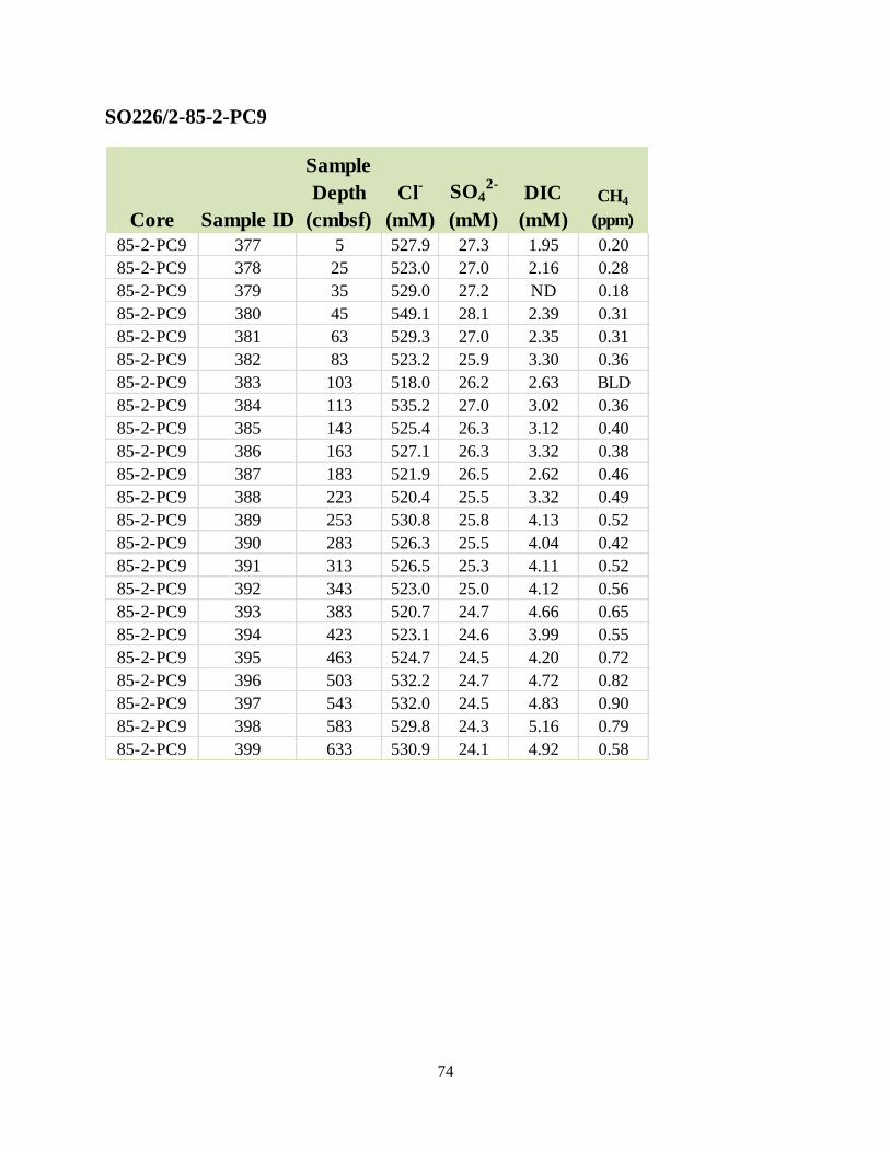
74
SO226/2-85-2-PC9
Core Sample ID
Sample
Depth
(cmbsf)
Cl-
(mM)
SO42-
(mM)
DIC
(mM)
CH4
(ppm)
85-2-PC9 377 5 527.9 27.3 1.95 0.20
85-2-PC9 378 25 523.0 27.0 2.16 0.28
85-2-PC9 379 35 529.0 27.2 ND 0.18
85-2-PC9 380 45 549.1 28.1 2.39 0.31
85-2-PC9 381 63 529.3 27.0 2.35 0.31
85-2-PC9 382 83 523.2 25.9 3.30 0.36
85-2-PC9 383 103 518.0 26.2 2.63 BLD
85-2-PC9 384 113 535.2 27.0 3.02 0.36
85-2-PC9 385 143 525.4 26.3 3.12 0.40
85-2-PC9 386 163 527.1 26.3 3.32 0.38
85-2-PC9 387 183 521.9 26.5 2.62 0.46
85-2-PC9 388 223 520.4 25.5 3.32 0.49
85-2-PC9 389 253 530.8 25.8 4.13 0.52
85-2-PC9 390 283 526.3 25.5 4.04 0.42
85-2-PC9 391 313 526.5 25.3 4.11 0.52
85-2-PC9 392 343 523.0 25.0 4.12 0.56
85-2-PC9 393 383 520.7 24.7 4.66 0.65
85-2-PC9 394 423 523.1 24.6 3.99 0.55
85-2-PC9 395 463 524.7 24.5 4.20 0.72
85-2-PC9 396 503 532.2 24.7 4.72 0.82
85-2-PC9 397 543 532.0 24.5 4.83 0.90
85-2-PC9 398 583 529.8 24.3 5.16 0.79
85-2-PC9 399 633 530.9 24.1 4.92 0.58
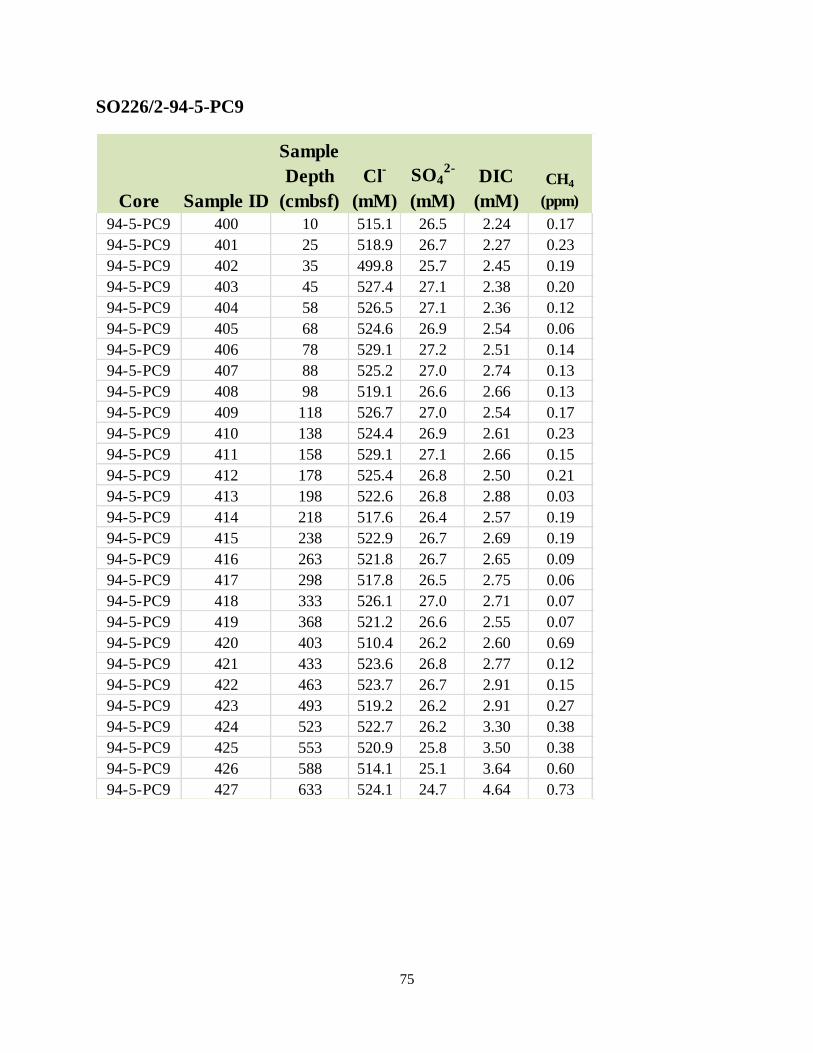
75
SO226/2-94-5-PC9
Core Sample ID
Sample
Depth
(cmbsf)
Cl-
(mM)
SO42-
(mM)
DIC
(mM)
CH4
(ppm)
94-5-PC9 400 10 515.1 26.5 2.24 0.17
94-5-PC9 401 25 518.9 26.7 2.27 0.23
94-5-PC9 402 35 499.8 25.7 2.45 0.19
94-5-PC9 403 45 527.4 27.1 2.38 0.20
94-5-PC9 404 58 526.5 27.1 2.36 0.12
94-5-PC9 405 68 524.6 26.9 2.54 0.06
94-5-PC9 406 78 529.1 27.2 2.51 0.14
94-5-PC9 407 88 525.2 27.0 2.74 0.13
94-5-PC9 408 98 519.1 26.6 2.66 0.13
94-5-PC9 409 118 526.7 27.0 2.54 0.17
94-5-PC9 410 138 524.4 26.9 2.61 0.23
94-5-PC9 411 158 529.1 27.1 2.66 0.15
94-5-PC9 412 178 525.4 26.8 2.50 0.21
94-5-PC9 413 198 522.6 26.8 2.88 0.03
94-5-PC9 414 218 517.6 26.4 2.57 0.19
94-5-PC9 415 238 522.9 26.7 2.69 0.19
94-5-PC9 416 263 521.8 26.7 2.65 0.09
94-5-PC9 417 298 517.8 26.5 2.75 0.06
94-5-PC9 418 333 526.1 27.0 2.71 0.07
94-5-PC9 419 368 521.2 26.6 2.55 0.07
94-5-PC9 420 403 510.4 26.2 2.60 0.69
94-5-PC9 421 433 523.6 26.8 2.77 0.12
94-5-PC9 422 463 523.7 26.7 2.91 0.15
94-5-PC9 423 493 519.2 26.2 2.91 0.27
94-5-PC9 424 523 522.7 26.2 3.30 0.38
94-5-PC9 425 553 520.9 25.8 3.50 0.38
94-5-PC9 426 588 514.1 25.1 3.64 0.60
94-5-PC9 427 633 524.1 24.7 4.64 0.73

76
SO226/2-95-1-PC9
Core Sample ID
Sample
Depth
(cmbsf)
Cl-
(mM)
SO42-
(mM)
DIC
(mM)
CH4
(ppm)
95-1-PC9 428 10 513.1 26.4 2.48 0.11
95-1-PC9 429 30 519.0 26.7 2.56 0.13
95-1-PC9 430 50 520.5 26.7 2.61 0.05
95-1-PC9 431 70 528.0 27.1 2.50 BLD
95-1-PC9 432 90 523.6 27.0 2.64 0.12
95-1-PC9 433 110 530.6 27.3 2.63 0.16
95-1-PC9 434 142 517.4 26.6 2.65 0.16
95-1-PC9 435 172 523.7 26.8 2.79 0.17
95-1-PC9 436 202 525.4 26.9 2.70 0.22
95-1-PC9 437 232 513.9 26.2 2.78 0.21
95-1-PC9 438 262 520.6 26.5 4.23 0.21
95-1-PC9 439 292 522.9 26.6 2.75 0.24
95-1-PC9 440 317 514.1 26.6 2.88 0.21
95-1-PC9 441 337 517.8 26.6 2.71 0.22
95-1-PC9 442 357 508.6 26.1 2.90 0.16
95-1-PC9 443 377 508.8 26.4 1.28 0.10
95-1-PC9 444 392 518.7 26.8 2.77 0.02
95-1-PC9 445 402 508.2 26.2 2.71 0.17
95-1-PC9 446 417 517.6 26.7 2.64 0.63

77
SO226/2-96-1-PC9
Core Sample ID
Sample
Depth
(cmbsf)
Cl-
(mM)
SO42-
(mM)
DIC
(mM)
CH4
(ppm)
96-1-PC9 447 10 511.1 26.3 2.45 0.24
96-1-PC9 448 30 528.1 27.2 2.49 0.48
96-1-PC9 449 50 527.4 27.0 2.64 0.47
96-1-PC9 450 65 519.2 26.6 2.65 0.40
96-1-PC9 451 75 524.4 26.9 2.69 0.32
96-1-PC9 452 90 524.4 26.9 2.70 0.30
96-1-PC9 453 110 525.0 27.0 2.49 0.24
96-1-PC9 454 130 514.5 26.4 2.73 0.32
96-1-PC9 455 145 526.8 27.1 2.54 0.22
96-1-PC9 456 155 522.5 26.9 2.66 0.26
96-1-PC9 457 175 523.2 26.9 2.51 0.16
96-1-PC9 458 205 510.4 26.3 2.59 0.98
96-1-PC9 459 235 524.3 27.1 2.57 0.09
96-1-PC9 460 265 524.6 27.0 2.38 0.16
96-1-PC9 461 297 514.8 26.5 2.60 0.21
96-1-PC9 462 327 525.7 27.0 2.52 0.18
96-1-PC9 463 357 522.3 26.9 2.68 0.16
96-1-PC9 464 387 521.5 26.8 2.37 0.19
96-1-PC9 465 417 513.9 26.6 2.43 0.27
96-1-PC9 466 447 521.4 26.8 2.72 0.23
96-1-PC9 467 477 520.7 26.6 2.99 0.33
96-1-PC9 468 507 517.9 26.4 3.10 0.44
96-1-PC9 469 537 546.1 27.8 3.15 0.52
96-1-PC9 470 562 523.3 26.6 3.65 0.53
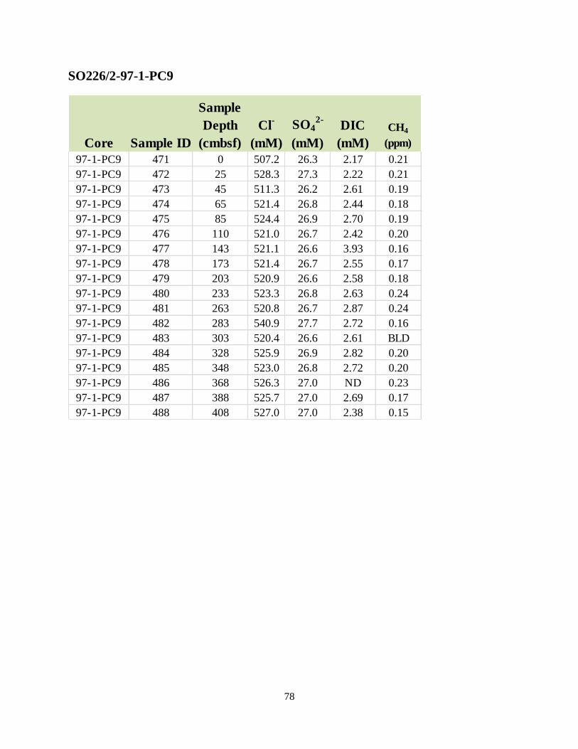
78
SO226/2-97-1-PC9
Core Sample ID
Sample
Depth
(cmbsf)
Cl-
(mM)
SO42-
(mM)
DIC
(mM)
CH4
(ppm)
97-1-PC9 471 0 507.2 26.3 2.17 0.21
97-1-PC9 472 25 528.3 27.3 2.22 0.21
97-1-PC9 473 45 511.3 26.2 2.61 0.19
97-1-PC9 474 65 521.4 26.8 2.44 0.18
97-1-PC9 475 85 524.4 26.9 2.70 0.19
97-1-PC9 476 110 521.0 26.7 2.42 0.20
97-1-PC9 477 143 521.1 26.6 3.93 0.16
97-1-PC9 478 173 521.4 26.7 2.55 0.17
97-1-PC9 479 203 520.9 26.6 2.58 0.18
97-1-PC9 480 233 523.3 26.8 2.63 0.24
97-1-PC9 481 263 520.8 26.7 2.87 0.24
97-1-PC9 482 283 540.9 27.7 2.72 0.16
97-1-PC9 483 303 520.4 26.6 2.61 BLD
97-1-PC9 484 328 525.9 26.9 2.82 0.20
97-1-PC9 485 348 523.0 26.8 2.72 0.20
97-1-PC9 486 368 526.3 27.0 ND 0.23
97-1-PC9 487 388 525.7 27.0 2.69 0.17
97-1-PC9 488 408 527.0 27.0 2.38 0.15

79
SO226/2-98-1-PC9
Core Sample ID
Sample
Depth
(cmbsf)
Cl-
(mM)
SO42-
(mM)
DIC
(mM)
CH4
(ppm)
98-1-PC9 489 10 710.4 36.6 1.81 0.97
98-1-PC9 490 25 789.9 41.8 2.15 0.79
98-1-PC9 491 45 813.8 43.6 1.91 0.33
98-1-PC9 492 70 739.9 39.4 2.57 0.22
98-1-PC9 493 105 524.5 27.1 2.51 0.16
98-1-PC9 494 135 523.0 27.0 2.50 0.16
98-1-PC9 495 155 519.5 26.7 2.74 0.17
98-1-PC9 496 175 525.4 27.0 2.73 0.15
98-1-PC9 497 195 527.3 27.1 2.76 0.29
98-1-PC9 498 215 524.2 27.0 2.81 0.25
98-1-PC9 499 235 526.8 27.1 2.70 0.28
98-1-PC9 500 255 529.0 27.2 2.96 0.29
98-1-PC9 501 280 527.4 27.1 3.05 0.27
98-1-PC9 502 306 519.7 26.7 2.98 0.27
98-1-PC9 503 321 524.6 26.9 3.04 0.31
98-1-PC9 504 341 524.5 26.8 3.17 0.40
98-1-PC9 505 366 524.7 26.7 3.47 0.30
98-1-PC9 506 401 524.7 26.7 3.47 0.18
98-1-PC9 507 426 526.2 26.7 3.78 0.30
98-1-PC9 508 456 526.3 26.6 3.63 0.29
98-1-PC9 509 486 521.8 26.4 3.74 0.31
98-1-PC9 510 516 526.3 26.6 3.80 0.37
98-1-PC9 511 541 568.5 29.9 4.09 0.37
98-1-PC9 512 566 705.7 39.8 3.48 0.71

80
Appendix 4: Sample Summary
Total number of samples collected from the piston cores. Samples for carbon and nitrogen
concentration and stable isotope abundance, 230
Th and 231
Pa analyses will be subsampled from
the sediment porosity jars at NRL.
Sed
CH4
Sed
Porosity
Sed
C-14
Sed
Pb-
210
PW SO4
+
Cl
PW
DIC
δ13C
DIC
PW
DOC
PW Sulfide
1000
μL
PW
Sulfide
250 μL
PW
Sulfide
25 μL
PW
Archive
SO226/2-030-2-PC9 19 19 19 19 19 19 19 19 19 19 19 19
SO226/2-033-1-PC9 11 12 12 12 12 12 12 12 12 12 12 12
SO226/2-044-1-PC9 21 21 21
21 21 21 21 21 21 21 21
SO226/2-045-2-PC9 25 25 25 25 25 25 25 25 25 25 25 25
SO226/2-047-1-PC9
1
SO226/2-051-2-PC9 23 23 23
23 23 23 23 23 23 23 23
SO226/2-052-1-PC9 23 23 23
23 23 23 23 23 23 23 23
SO226/2-053-1-PC9 25 25 25
25 25 25 25 25 25 25 25
SO226/2-054-1-PC9 27 27 27
27 27 27 27 27 27 27 27
SO226/2-073-2-PC9 21 21 21
21 21 21 21 21 21 21 21
SO226/2-074-1-PC9 24 24 24
24 24 24 24 24 24 24 24
SO226/2-075-2-PC9 27 27 27 27 27 27 27 27 27 27 27 27
SO226/2-076-2-PC9 24 24 24
24 24 24 24 24 24 24 24
SO226/2-077-2-PC9 23 23 23 23 23 23 23 23 23 23 23 23
SO226/2-082-3-PC9 26 26 26
26 26 26 26 26 26 26 26
SO226/2-083-1-PC9 28 28 28
28 28 28 28 28 28 28 28
SO226/2-084-1-PC9 28 28 28
28 28 28 28 28 28 28 28
SO226/2-085-2-PC9 23 23 23 23 23 23 23 23 23 23 23 23
SO226/2-094-5-PC9 28 28 28 28 28 28 28 28 28 28 28 28
SO226/2-095-1-PC9 19 19 19
19 19 19 19 19 19 19 19
SO226/2-096-1-PC9 24 24 24
24 24 24 24 24 24 24 24
SO226/2-097-1-PC9 18 18 18
18 18 18 18 18 18 18 18
SO226/2-098-1-PC9 24 24 24 24 24 24 24 24 24 24 24 24
SO226/2-100-1-PC9 12 12 12 12 12 12 12 12 12 12 12 12
total 523 524 525 193 524 524 524 524 524 524 524 524

81
Total number of samples collected from the multicores. Samples for carbon and nitrogen
concentration and stable isotope abundance, 230
Th and 231
Pa analyses will be subsampled from
the sediment porosity jars at NRL.
Sed
Porosity
Sed
C-14
Sed
Pb-210
SO226/2-037-1-MUC 13 13 13
SO226/2-038-1-MUC 8 8
SO226/2-039-1-MUC 39 39 39
SO226/2-040-1-MUC 13 13
SO226/2-041-1-MUC 22 22 22
SO226/2-042-1-MUC 13 13
SO226/2-048-1-MUC 22 22
SO226/2-049-1-MUC 25 25
SO226/2-050-1-MUC 34 34
SO226/2-051-1-MUC 12 12
SO226/2-061-1-MUC 35 35
SO226/2-063-1-MUC 35 35 SO226/2-068-1-MUC 34 34 34
SO226/2-069-1-MUC 15 15 SO226/2-071-1-MUC 16 16 16
SO226/2-072-1-MUC 11 11
SO226/2-073-1-MUC 16 16
SO226/2-079-1-MUC 42 42 42
SO226/2-080-2-MUC 20 20
SO226/2-081-1-MUC 27 27 27
SO226/2-082-2-MUC 28 28
SO226/2-090-1-MUC 22 22 22
SO226/2-091-1-MUC 36 36 36
SO226/2-092-1-MUC 22 22 SO226/2-093-1-MUC 41 41 SO226/2-101-2-MUC 23 23 23
SO226/2-102-1-MUC 18 18 18
SO226/2-103-1-MUC 20 20
SO226/2-104-1-MUC 38 38 38
total 700 700 330