Embed Size (px)
Citation preview

NAVIGATION
GEOL 1033,
General Oceanography
Lesson 5 in the Study Guide

Polynesian Stick Chart• A modern Micronesian stick chart.
Shells at the junctions between bamboo sticks represent islands. Straight strips represent patterns of regular waves; bent strips represent waves bending in shallow water around the islands.
• A Polynesian voyaging canoe with a double-hulled design. This is one of many types of small, ocean-going boats used by Polynesians to sail across much of the Pacific Ocean long before the invention of modern navigational instruments.
• The Polynesians used wave directions, stars, weather and cloud patterns, water taste,
and other natural phenomena as navigational indicators.
DEVELOPMENT OF MODERN NAVIGATIONAL INSTRUMENTATION & METHODS
• Magnetic compass• Astrolabe• Quadrant• Sextant• Hourglass• Chronometer • Dead reckoning• Triangulation• Radio navigation• Radar navigation• Satellite navigation

MAGNETIC COMPASS• Provides a reference for determining direction
• From China to Moslems to Southern Europe
• Magnetic pole different from rotational pole
• Magnetic field varies
• Corrections needed

MAP• South magnetic
pole

Navigational Instruments - The Astrolabe• A brass mariner's astrolabe, one of
the best early navigation instruments -- it allowed navigators to read the altitude of the sun or stars.

HOURGLASS used to determine longitude• A postage stamp from Portugal depicting a suspended
hour-glass, one of the early instruments used to tell time, an essential for navigation (specifically, the determination of longitude) on the high seas. Crude devices such as this were useful for a few days voyage at best. Only with the development of precise, stable, motion insensitive, spring-driven chronometers in the 1700's was the dream of precise navigation realized.

Christopher Columbus's Navigational Instruments• A postage stamp from the
Bahamas showing early navigational instruments used by Columbus in his voyages of discovery. The compass (invented in about the 12th Century), the hourglass, and very crude charts supplemented navigation by dead reckoning.
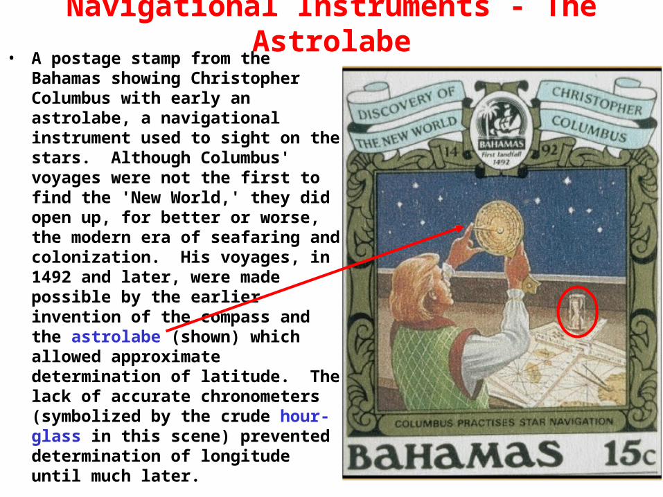
Navigational Instruments - The Astrolabe• A postage stamp from the
Bahamas showing Christopher Columbus with early an astrolabe, a navigational instrument used to sight on the stars. Although Columbus' voyages were not the first to find the 'New World,' they did open up, for better or worse, the modern era of seafaring and colonization. His voyages, in 1492 and later, were made possible by the earlier invention of the compass and the astrolabe (shown) which allowed approximate determination of latitude. The lack of accurate chronometers (symbolized by the crude hour-glass in this scene) prevented determination of longitude until much later.

QUADRANT• John Cabot (originally Giovanni Cabotto) - Italian-born explorer led the first
English expedition to discover the North American mainland in 1497. Shown here with a QUADRANT, an early navigational instrument used to measure the altitude of celestial bodies (a precursor to the more modern sextant). The quadrant could only measure angles to 90 degrees.

SEXTANT• Sextant was invented in the mid-18th Century
• Measure angles up to 120°
• Easier to use than the quadrant• More than any other instrument, enabled precise navigation on the high seas.
This instrument allows the determination of the angle between the horizon and a celestial feature like the north polar star, thus allowing the calculation of one's latitude. Longitude, however, could still only be determined by knowing the precise time, a difficult task with primitive chronometers. Thus, many explorers sailed to a particular latitude and sailed east or west along it:
termed 'running down the latitude.'

DETERMINING LATITUDE WITH ANGLE OF POLARIS
• At equator (0°), the North Star will be on the horizon at 0°• Here, Wolfville or Windsor,it will be about 45° above the horizon
• At the north pole, it will be at the zenith (directly overhead) at 90°

CHRONOMETER• John Harrison's fourth marine
time piece revolutionized ocean navigation.
• Harrison began to develop a whole new type of marine timepiece in 1755 (relatively small based on the design of a pocket watch with a large balance oscillating 5 times per second and a bimetallic strip that compensated for temperature variations).
• Remarkable accuracy earned Harrison his sobriqet of "Father of Longitude."

• 15° longitude/hour15° prime meridian

DEVELOPMENT OF MODERN NAVIGATIONAL INSTRUMENTATION & METHODS
• Magnetic compass• Astrolabe• Quadrant• Sextant• Chronometer
• Dead reckoning• Triangulation• Radio navigation• Radar navigation• Satellite navigation

DEAD RECKONING• Determine position
• Follow plotted course direction for a specified time & speed
• Redetermine position sometime later
• "Ship's drift" is the amount off course, possibly because of horizontal surface ocean currents, winds, etc.

TRIANGULATION• Determine bearings (direction) to at least 2, preferably 3,
known points
• Draw straight lines on the chart along these directions from these points
• Where they intersect should be your position

RADAR NAVIGATION• RADAR = Radio Detecting And Ranging• Relatively low-frequency EM signal that bounces back• Provides:
– bearing = direction
– range = distance
• Usually for line-of-sight for a few 10's km nearshore

RADIO NAVIGATION• Specialized radio stations
transmit a repeating signal with a constant time delay between each signal (beeps)
• A ship's receiver when receiving 2 or more such beacons can convert the different times of arrival of the different signals into distances which are then converted into a location or position on a chart.
• This system is being replaced by the GPS

Global Positioning System (GPS)• U. S. maintains 24 Global Positioning System (GPS) satellites in
orbit around Earth.
• They broadcast signals containing location, time, & other data.
• Through an antenna, GPS receivers pick up and interpret the signals from multiple satellites to determine a person's position, altitude, speed, and direction of travel.

GPS• GPS has of 3 major components:
– 1. User Segment
– 2. Control Segment
– 3. Space Segment
• The user segment is a specialized GPS radio receiver designed to detect and interpret multiple GPS satellite signals & calculate a person's position, altitude, speed, and direction of travel.– Civilian receivers were accurate to ~76-100 m, now to about 3 m best
– U.S. military grade receivers contain cryptographic modules that allow them to use signals that have been encrypted for accuracies to level of cm
– Research oriented accuracies to mm's are possible with modifications, but calculations are lengthy & time-consuming
GPS satellite

GPS• The NAVSTAR control segment is composed of 5 monitor
stations, a master control station (MCS) & uplink antennas.– a) Monitor stations are GPS receivers that track all satellites in view &
accumulate ranging data from the satellite signals. They are located at Colorado Springs, Hawaii, Ascencion Island, Diego Garcia and Kwajalein. These stations send the raw data back to MCS for processing.

GPS– b) The Master Control Station (MCS)
• Is located in Colorado & is managed by the U.S. Air Force
• Information & corrections calculated by MCS are transmitted to the satellites by ground-based uplink antennas.

GPS• The Space segment of GPS
– 24 satellites 20 200 km from Earth in 6 circular orbital planes inclined 55°– 4 per orbit (every 90°) – With a 12-hour period
– Satellite spacing arranged for minimum
detection of 5 from any location
– Satellites transmit time, position, etc.,
on 2 frequencies
– Satellite signals are doppler-shifted
when they reach receiver
– Navigation data is superimposed on
a "precise" (P) code & on a
"coarse/acquisition" (C/A) code
– P code is normally encrypted, so
that only the less accurate C/A code
is available to civilian users!

GPS
• Each GPS satellite radios data every 30 seconds, including its location & time of transmission.
• Calculating how long the signal took to travel from satellite to receiver, your receiver can determine the distance between them.
• Your location, therefore, lies somewhere on the sphere defined by that distance as its radius.
• With the distance from a second satellite, your location is narrowed down to the circumference of the circle where the two spheres intersect.

GPS• A third satellite results in two points where all three spheres
intersect. – One of these points is way out in space
– The other is your location
• A 4th & 5th satellite improves accuracy

PLOTTING THE SHORTEST COURSE• Draw a straight line on a great circle chart between 2
points• Determine latitudes & longitudes of points at intervals
along this line
• Transfer these points to a Mercator projection chart

PLOTTING THE SHORTEST COURSE• Connect these points on the Mercator projection chart
to obtain line segments approximating the curved (usually) path representing the shortest distance.
• Each line segment will be oriented along a true compass direction
• Steer along these gradually changing courses to follow a route of shortest distance

END OF FILE