Embed Size (px)
Citation preview

Nd/S. T*NAIL H*.EU MA.GTUESITE IJMXTET}
(A Government of Tamil Nadu Undertaking)
^&NASK3 ffi&ffiNffiSKWK ffiKNffiS
CAPTM MrNES/RESERVE FOREST r.AND/OPENCAST MINING - MAGNESmE & DfrNmE
Thathiengarpatti Village, Salem Forest Division, Shevaroys (South) Range,
Kurumbampatti Reserve Forest, Salem &Tamil Nadu
Project Area - 96.34 hectares
Proposed Production of Magnesite - 1,24,260 TPA & Dunite - 1, 33,698 TPA
Environmental Clearance under EIA l$otification - 2OOo
$chedule Sl. I[o. 1 (a] (i]: Category - 'B' {Mining < lOO ha}
EXECUTNTE SUMMARYFor Public Hearlng
(TOR Awarded vide Letter I{o. J-11O1516412A18-IA.II lMl Dated: 08-11-2O19}
N*x'epxxb*r X$XS
i*
EIA Consultant
6ES EXPLS&.&TION .&NE} MTNIN@ $StUTTO$S
Old Ho. 26A-B, New IYo. t7,' Advaitha Ashrarn Road, Alagapuraff!,
Salern - 636 O04, Tamil l$adu, lndiaAccredited for sector 1, 28 & 38 Category 'A'
Certilicate No: NABEI lBlj.l 182llRAO123
&acl

1. INTRODUCTION:
Arasu Magnesite Mines is operated by 1\{/s. Tamil Nadu Magnesite Limited
(TAIIMAG), a Government of Tamil Nadu undertaking, for Mining of Magnesite and Dunite
by opencast mechanized method in Kurumbampatti Reserve Forest Land, Salem.
Arasu Magnesite Mines falls on northern extremity of the northem belt of the chalk
hills of Salem comprising of northem and southern belt of ultramafic rocks occurring as
intrusive hydro-thernal fluids and are separated by gneissic rocks. The Magnesite vein
thickness ranges from a fraction of centimeter as much as 150 centimeters. The Magnesite
deposits has emplaced as veins on ENE-WSW directions.
Magnesite Mineral is an essential raw material for manufacturing Refractory
Materials used by Steel Industry. This is a rare mineral available in Salem Region of Tamil
Nadu State and is also found in other states like Uttarakhand, Kamataka and Jammu &
Kashmir.
Magnesite of Salem Region is relatively low in Calcium Oxide. Salem Magnesite
Reserves are famous worldwide for its Cryptocrystaline Strucfure, which is best suited for
manufacturing Refractory Bricks.
Realizing the necessity for preservation and proper exploitation of such rare mineral,
the Govemment of Tamil Nadu formed Tamil Nadu Magnesite Limited popularly known as
TANMAG in January 1979. From the raw Magnesite produced from the mines, company is
producing Dead Burnt Magnesite (DBM) at Rotary Kiln Division (RI(D) and Lightly
Calcined Magnesite (LCIO at Shaft Kiln Division (SKD). The company has its own captive
mine and two factories to produce DBM and LCM of various grades.
The Contact information of the Corporate Office is:
The Chairperson and Managing Director
lWs. Tamil Nadu Magnesite Limited
(A Govt. of Tamil Nadu Undertaking)
5/53, Omalur Main Road,
Jagir Ammapalayam Post, .
Salem, Tamil Nadu
Pin Code - 636 302
Phone (General): +91 - 427 -234633312346334
E-mail: [email protected]
tanma g. salem@ gmail. com
Page l2

The above mine was earlier operated for more than 50 years by N{/s. Salem Magnesite
Private Limited (SMPL). Government of Tamil Nadu, Industries Department vides G.O. Ms.
No. 1445 Dated: 13.11.1978 issued order for reserv.ing Sy. No. 153 over an extent of 578.92
acres in ThathaiyangarpatnVillage, Omalur Taluk, Salem Dishict for State Exploitation.
Govemment of Tamil Nadu, Industries Department vide G.O. Ms. No. 41 Dated:
10.01.1979 issued order for formation of "Tamil Nadu Magnesite Limited" and operated
Arasu Magnesite Mines (578.92 acres) as a "Raising Contractor" for and on behalf of
Government of Tamil Nadu &om lgTg till lgg8.
Arasu Magnesite Mines obtained Forest Clearance from Government of India,
Minisfiy of Environment & Forests vide No. 8-53197-FC Dated:23.06.1998 for diversion of
177.96 haof forestlandforrenewalof miningleaseinfavourof lWs. TamilNaduMagnesite
Limited., for mining of Magnesite & Dunite under Section - 2 of Forest (Conservation) Act,
1980.
Subsequently, Government of Tamil Nadu Environment & Forest (FRX) Deparbnent
G.O. (Ms.) No. 234 Dated: 06.08.1998 granted renewal of lease over an extent of 1,77.96 ha
of forest land in Kurumbampatti reserve forests of Shevaroys South Range of Salem Division
for mining of Magnesite and Dunite.for a period of 10 Years.
Renewal proposal for diversion of 96.34 ha of forest land (Reserved Forest) for
mining of Magnesite and Dunite by TANMAG was granted under Section - 2 of the Forest
(Conservation) Act, 1980 subject to fulfrlment of the conditions vide F.No.8 - 53/97 - FC
Dated: 14.07.2008, Ministry of Environment & Forest (F.C. Division) and subsequently,
Goverrment of Tamil Nadu Environment and Forests (FR.10) Department G.O. (Ms.) No. 79
Dated: 12.08.2008 granted Diversion of 96.34 ha Forest Land - Renewal of lease of forest
land for mining Magnesite & Dunite for a period of 20 Years subject to possession of valid
lease by the user agency under the MMDR Act, 1957.
Mining of Magnesite & Dunite was carried out after obtaining necessary permissions
like -1. Explosive Ligense for storage and handling as per Explosive Act, 1884 Dated:
28.07.1979 & subsequent renewal which is valid till date as per Explosive Rules,
2008
2. Obtained CTO for the quantity of 1,14,000 tonnes Magnesite from TNPCB since
1993 (Valid till 3 1.03.2021)
Page | 3

Permission for adopting a system of deep-hole blasting and working opencast mines
with HEMM obtained from DGMS under Regulation 106 (2) (b) as per MMR, 1961
(Memo No. D/A4l6071 Dated: 21.11.1996)
IBM Approved Mining Plan, Scheme of Mining, Mine Closure Plan and Review of
Mining Plan Approved (2018 -2023)
Later, MoEF & CC vide Leffer No. Z-11013/8912017-IA.II (M) Dated: 12.04.2018
directed to apply under violation sector as per S.O. No. 804 (E) Dated: 14.03.2017 and
comply all the provisions mentioned in the Judgement of the Hon'ble Supreme Court Dated:
02.08.2017 in the Common Cause vs UoI.
Arasu Magnesite Mines has stopped fhs mining operations w.e.f 14.04.2018 and
applied for Environmental Clearance for ToR to MoEF & CC vide online proposal no.
IA/TNAyIIN/74485/2018 Dated: 13.04.2018, which was re-submitted after essential details
sought by MoEF & CC on 30.05.2018.
The proposal was placed in 33'd EAC meeting held'on 22.06.2018, EAC deliberated
the matter and requested the Ministry to take a decision whether the proposal to be
transferred to violation category on 22-06.2018.
As per the Gazette Notification 5.O.3977 Dated: 146 August 2018, Arasu Magnesite
Mine (96.354 ha) falls under Category 'B' (Since mining area ( 100 ha) and shall be
appraised by respective SEIAA.
TANMAG applied online on 10ft November 2018 to SEIAA for grant of ToR for
Envirormental Clearance. The proposal seeking ToR was placed before the 121't State Expert
Appraisal Committee (SEAC) Meeting held on 30. 1 1.201 8. The SEAC recommended that the
proponent may approach MoEF & CC to transfer the online application fded by the
proponent to MoEF & CC.
The proposal seeking ToR was placed before 124it' SEAC meeting held on O4.Ol.z}tg
and the minutes of the same were upload in the SEAC portal.
The parivesh.portal status Dated: 28.02.2019 listed the proposal of Arasu Magnesite
Mine as a case of Violation and was placed in 23'd EAC meeting (violation category) under
Agenda No. 23.3.5 and was appraised in 24th EAC meeting (Violation Category) Dated:
24.07 .2019 under Agenda No: 24.5.5 for issue of ToR and was awarded ToR vide Letter No.
J -l l0l 5 / 64120 I 8-IA.II (M) Dated: 08- I 1 -20 1 9.
Public Hearing is being conducted as per conditions of Terms of reference.
aJ.
4.
Page | 4

2. PROJECT DESCRIPTION:
Sl.No. DESCRIPTION DETAILS1 Name of Mine Arasu Magnesite Mine2 Proiect Proponent M/s. Tamil Nadu Magnesite Limited
J Location
Thathiengarpatti Village,Omalur Taluk,
Salem District,Tamil Nadu State
4 Classification of Land
Reserve Forest Land,
Salem Forest Division,Shevaroys (South) Range,
Kurumbampatti Reserve Forest
5 Extent 96.34ha
6 TopographyHilly terrain with gradient towards south
Highest Elevation-3 72m AMSL7 Ground Water Table 322- 312 AMSL8 Latitude between 11"44' 46.33"N to 1 1
o45'35.93"N
9 Longitude between 78'08'54. 10"E to 78o09' 42.87"E
10Review of Mining Plan
(20 I 8-20t9 to 2022-2023)
Approved by Indian Bureau of Mines videLeffer No. TN/SLIWMG/ROMP- 1483.MDS
Dated: 04.05.201 8
11 Geological Resources 5,98,53,388 Tonnes
t2 Mineable Reserves 4,56,08,600 Tonnes of ROMt3 Magnesite @8%recovery 6,00,590 Tonnes (5 Year Mining Plan Period)
t4 Dunite @,5% recovery 5,67,077 Tonnes (5 Year Mining Plan Period)
15 Mine ConfigurationThe Mine Lease Area is divided into 3 Blocks (A, B & C), the
Ultimate Pit Limit is 314 m from the highest elevation of 372
m AMSLt6 Bench Confizuration 5m Height & 5m Width with 60u - 80o Slope
t7 Existing Pit Dimension
Block A Block B Block C
Leneth (m) 533 447 420
Width (m) 301 437 393
Depth (m) 38 26 2t
18 Waste / SpoilThe entire lease area is mineral bearing; hence the spoiVwaste
will be simultaneously backfilled in the mined out area innorthern side of the mine.
t9 Manpower 1017 Nos
20 Proiect Cost 9.23 Crores
21 Power Requirements
The project does not require any power supply for the miningoperations Electricity is used only in office premises and otherinternal infrastructure for which necessary permission has been
obtained from TNEB.
22 Working Hours
General Shift 8 AM - 5 PM for Mineral Segregation (LunchBreak 12 Noon - 1 PM) and In Overlapping Shifts for SpoilRemoval (6 AM to 2 PM) & (12 Noon to 6 PM)
23 Drilling & BlastingDeep-hole drilling of 110 mm diameter by engaging WagonDrills along with Air Compressor and primary blasting is done
with 83 mm diameter Slurry Explosives
Page | 5

24 Existing Land Use Paffem
Area Zone Area in ha
Effective MiningArea
Current plan period
(Block-A & B)3r.32
Broken area
Mine Pit 21.7s
ExistingTemporary Waste
Dump
20.25
Unbroken areaGreen belt area &
utilities23.02
Total 96.34
25
Site ConnectivitvNearest National Highway NH-7) Srinagar-Kanyakumari 9 km SW
Nearest State Highway (SH-188) Salem Yercaud Ghat Road 3.15 km East
Nearest Railway Station Karuppur 8.4 km SW
Nearest Airport Salem Airport 10.85 km NW
26 Environment S ensitivity
No protected areas notified under The Wild life (Protection)
Act,1972, no critically polluted areas as notified by the centralpollution control board constituted, no notified eco-sensitive
areas, no interstate boundaries and intemational boundaries, no
national parks, biosphere reserves, elephant corridors,mangrove forest, archeological monuments, heritage site etc.
within 10km radius from mine lease area.
27 Nearest Water Bodies
Vattakadu Eri 3.0 km SW
Kannankurichi Puthu Eri 5.5 km SE
East Sarabanga fuver 8.50 km SW
Yercaud Lake 6.0 km NE (Upstream)
28 Nearest Habitation Sengaradu Village 1.0 km South West
29 Captive Plant
The mined out quantity of Magnesite is transported ftommines to captive plants viz, Shaft Kiln Division and RotaryKiln Division for manufacture of Lightly Calcined Magnesiteand Dead Burnt Magnesite respectively. Dunite is sold toauthorized buyers.
30 CSR Activities The company has spent an amount of Rs 335.39 Lakhs till date
31 Seismic SensitivityProject area is categorized as Zone III, Moderate Risk Zone as
per BMTPC, Vulnerability Atlas of Seismic Zone of India IS:
t893 -2002
Page | 6

i . t -'xr,",ti
$*' I rv.rore ? -wts"t'
1 x*rtrrrgia I 'x8$chiPurtm\ L rpiurraamrtl
LOCATION DETAILS _
N
Source: Google Maps
,. I.'I
i:IilitI
."",*,i';..,1.
' j''.,l:,4;:;,'
:..,4,"'t':::: .:a::
::i::.:.+:::, , ,li
S L- I rpiurraamrtl
L om**un/ vr,upu*nr,t'#-qr
tr Nitgirir 19,666 I cuddeloro
Pcrrmbrlrn g6y31uy
Cgimb6tors f,lgmt*a| . Nagtp6tlinam
? . .. .Trlchy
Iituppot I l$'rt rTiruvarurI -''.r
Thanirvurr. .' '
..- .0indi!91
" * pudutr$lal
I ,,,,,
t1Nr*s&?,b &
:,..

rt : !llit
{ilg {,1$:t
i:izt,o!tE r.in rt;,
L> ! I tr= ! r !
to : F!1 ai *
::a, ifi, 331:*.**...-
e
;?5fai
lli'q 'o{' il t
i'{qi.- 7r
"i: ill.qE..rrx,s,r! ili i 11i i i 1 ,i,rl l
I it riii,iS:ii i
t; i I i t ir: l $ II i r I
iiiiiitiiiiiiiiiliirr; iiliii!II
H
t
"
4-YtIriit.
It
lr.1i";iIt
tiiil"{rl,l''i
o:""
* jliI l; :
;ltt Ii,ii;;!iIi!t;liiltriIi!Iii.i! tli!ti3,I r
l,i
t
rtt:t$
gttr!liTIi:.tt,
:3i
'lI t.
:{}rilr!{
i t'{
e
;}
e
6
p
fi
:{.€"
x
:._38
rtI
I
EI
ivc
J-tt--r. 2 2EA T E:;i. ;
' = *=-- I
, i!iEE*: <;FCi;
3 :.3E: eiu"i; $ c {l .i'= 7YE'zL 7 u>l- C
JT={ F"
E
jt.
a
3t-lFiIi*aFI
F.
zc
-*
r-'I-aFi11
Fiz-=a

o\
oboG
+rCO
lr.o
pi-zOoI
Oo<EZ-oLJJE >.=g <J
0) t:=I i
-* C )\-/U O U b.rri dtE t-r-E s
PH +EE! 1EH EEPB E
rii2.E#z H€od#Ea r 9oO r I - c1 N,aO\ -.=c * A< o IEi >N.H o.o.9N iI t (B I \O.<.qF I .qR3{rRqQs=ilO\tr-c.lg\fr#\O\nC\Ot-,{NO\tiHOO<+cANO\
+E€irrlFF-\pN*C\ 6'g i
S= i29Fl{; ft igai(r.i
6g
EE5 i
AsEEEisrFEEiE c$EE*i
i
E l"q i
f E*t "i
.svs<
'izad;62,z>.x 'J:crcgtrP

oEDo
!
*
Ag
nI
4
?:
xf
s
tu
UE9Q
CJ
,r.:i
7
E
.,;L:>
-$
Iil
il
3:l
liE4'E ALE Es&
E^3Er; T;; EFd!!!i.E< ;i.O r;
: Ufri -eg
3 g.EE-- *r3 ..
r o.IJ"x
F H Eg= EL ZC>Fe
{t
m$
,;F C
i..;}
lx' af]
E}
ta
:,Ht:,;7 v"
"ir 3.' _
- \":l
.., -* -: , .' '1"1' ,.\.,, ", . "! \, i.,.'\.::
i.l

3. DESCRIPTION OF TIIE ENVIRONMENT:
The baseline environmental monitoring was carried out during pre-monsoon season of
year March 2019 to May 2019 apart from environmental compliance monitoring which is
being carried out since 1998 as per Environment Safeguard conditions in Annexure - A of
FC.
Baseline data was generated for various environmental parameters including air,
water (surface and ground water), land and soil, ecology and socio-economic status to
determine qualrty of the prevailing environmental settings.
Study Area -For the description of baseline environmental scenario, the mine lease area is
considered as Core Zone and the area falling within a distance of 10 km radius (aerial
distance) from boundary of the core zone is considered as Buffir Zone. The core and buffer
zone combined together is referre d as Study Area for determination of baseline status and
assessment of environment impacts.
Considering the Environmental seffing of the project, project activities and their
interaction, environmental regulations and Standards, following Environmental Attributes
have been included in EIA Study.
' Site specific Micrometeorological Data (hourly readings from core zone) for the
Season on wind speed & direction (wind roses), temperature, humidity and rainfall.
. Ambient Air Quality Monitoring at 10 locations on 24-hourly basis, continuously for
2 days in a week for 4 weeks in a month during the season for the parameters PM2.5,
PMro, SPM (for Fugitive Dust analysis), SO2 and NO, as per NAAQ Nonns (Revised
as per GSR 826(E) Dated: 16.11.2009 for Industrial, Residential, Rural and other
Areas).
. Noise Level Measurements 4 location in core zone & 4 locations in buffer zone for
Leq, Lday and Lnight values once in the Season.
. Water Quality Monitoring - grab sampling once in a Season for:
o Surface Waters (2locations) as per CPCB Norms.
o Ground Waters (8 Locations) as per IS: 10500 Nomrs.
. Soil Quality Monitoring at l0locations once in the study period for:
o Textural & Physical Parameters
Page | 11

o Nutrients
' t Land use pattern based on Satellite knagery.
. Biotic Attributes (once in the study period) for Flora & Fauna-Core & Buffer zones
. Socio-Economic Profile based on Census 2011, for Total Population /Household Size
/ Age, Gender Composition, S.C I S.T, Literacy Level, Occupational Structure, etc.
The summary of baseline status is as below -AMBIENT AIR QUALITY:
PMro Values in pglm3-
AAQl AAQ2 AAQ3 AAQ4 AAQs AAQ6 AAQT AAQs AAQ9 AAQl0Min 12.8 33.1 33.2 32.4 34.7 30.s 35.8 34.5 35.5 34.6
Max 38.2 49.4 52.2 56.5 55.6 51.s 48.1 47.3 48.8 49.6
PM z.s Values in pglm3-
AAQl AAQ2 AAQ3 AAQ4 AAQs AAQ6 AAQT AAQs AAQe AAQI0
Min 10.8 10.6 10.4 l0 10.3 10.4 t5.2 16.1 16.2 15.1
Max 49.4 Z).J 26.4 27.t 28 24.8 29.2 25.5 24.9 25.7
SO2 Values in pglm3-
AAQl AAQ2 AAQ3 AAQ4 AAQs AAQ6 AAQT AAQ8 AAQ9 AAQro
Min 3.6 4.6 3.9 4.3 4.1 4.1 4.1 4.t 4.2 4.3
Max 8.6 12.3 15.1 9 8.8 9 7.6 8.1 8.3 7.8
NO* Values in pg/m3-
AAQl AAQ2 AAQ3 AAQ4 AAQs AAQ6 AAQT AAQ8 AAQ9 AAQI0
Min 10.9 3.9 8.3 10.2 10.1 9.8 10.4 11.5 12.6 12.2
Max 20.2 20.6 20.4 20.2 t9.4 20.8 17.8 18.6 19.6 22.8
The concentrations of PMro, PM2.5, SOz and NO2 are observed to be well within the
NAAQ standards prescribed by Central Pollution Control Board (CPCB) for industrial,
residential, rural & other areas.
WATER QUALITYI
Surface Water Quality -The pH varies from 7 .71 to 7 .89. The Total Dissolved Solids ranged from 72 mgll to
98 mg/l respectively. Chloride were found to be in the range of 8 mg/l to 12 mgl. The Heavy
Metal Content has been found to be well within the limit.
Page | 12

Ground Water Quality-
The pH and Conductivity varies from7.24 to 8.18. The Total Dissolved Solids ranged
from 235 mg/l to 584m9/1. Chloride were found to be in the range of 22mglLto 66 mg/I. The
water samples are observed to be well within the limits as per 15-10500:2012.
NOISE EI\MIROI\MENT:
Baseline noise levels were monitored, using continuous noise measurement device. Day
levels were monitored during 6 AM to l0 PM and the night levels during 10 PM to 6 AM.
From the results, it can be seen that the Day equivalents and the Night equivalents
were well within the CPCB Ambient Noise Standards of Industrial Area and Residential
Areas.
SOIL ENVIRONMENT:
10 soil sampling locations were selested and analysed.
Physical Characteristics -The physical properties of the soil samples were examined for texture, bulk density,
porosity and water holding capacity. The soil texture found in the study area is Loamy Soil
varying from Moderately Fine Texture to Moderately Coarse Texture and Bulk Density of
Soils in the study area varied between l.I7 to 1.32 grr I cnf .It can be inferred from the Bulk
Density, Water Holding Capacity and Porosity results of the soil samples that the water
retention in the area is found to be medium
Chemical Characteristics -The nature of soil varies from moderately alkaline to strongly alkaline with pH range
8.00 - 8.41. The Total Kjeldahl Nitrogen content in the soil samples range between 1.89
gm/100g to 3.07 grn/100g, which is sufficient as per ICAR classification. The Phosphorus
(gtr/100g) varies between 5.95 - 6.81, which is more than suflicient as per ICAR
classification. The Potash (gml100g) varies between 1.75 to 2.98, which is more than
sufficient as per ICAR. The organic carbon in the study area was also found to be low. Thus
the fertility of the soil in the area can be considered to be low to medium.
Noise Level In dB(A) Dav Equivalent Nieht EquivalentCore Zone (1 Location) 54.3 40.0
CPCB Limits 75 70
Buffer Zone (5 Locations) 50.4 39.9
CPCB Limits 55 45
Page | 13
LAND EI\MIRONMENT:
Land use pattem using recent satellite data were studied for Mining lease area and 10
km buffer zone. From the study it is seen that out of total study area of 36042.5I ha, mostly
covered with Forest (11003.23 }rra) 30.53%. Agriculture, Crop land & Plantation (14011.68
ha) 38.87%, Built-up, urban, Rural, Mining (5537.5 ha) 15.360/0 and water bodies/stream
occupies (512.7 I ha) 1.42%.
FLORA & FAUNA2
Ecological survey was carried out to understand baseline ecological status, important
floristic elements and fauna structure. The project area is reserve forest land and there are
various floral species in the study area.
"The project site does not have any species which fall under the Schedule I of The
Indian Wildlife (Protection) Act, 1972 or under threatened category of the ruCN Red List of
Threatened Species."
SOCIO ECONOMICS:
Sample survey was done to collect qualitative information about the socio economic
environment of the area. The Study area has all basic amenities such as roads, drinking water
facilities, township, educational institutions, temples, medical facilities & electricity facilities
and was evident during the site visit.
Though agriculture is the main occupation in the surrounding villages, it has provided
employment opportunities to only 50-60% of the families. The remaining population is
depending on other type of emploS/rnent opportunities mainly as labourers.
Page | 14

4. ANTICIPATED ENVIRONMENTAL IMPACTS AND MITIGATION MEASURES:
EN\IIRONMENTCOMPONENT
ANTICIPATEDIMPACTS
MITIGATION MEASURES
Land
Environment
o Change intopography and
drainage of lease
area.
o Change in Land use
ofthe lease area.
o Greenbelt development on waste dump,unutilized land & safety barrier.
o The Mine Pit will be used for rainwater storage.
o Proper dump and water management toprevent degradation of surrounding
land.
o Waste material will be stored in the pre
decided place. Quick vegetative cover
to check soil erosion
AirEnvironment
The likely sources forambient air pollutionwith respect toprdect activities are
generation of dust
during mining,transportation of the
material and release
of vehicular exhausts.
Fugitive ' Dust,
Particulate . Matters(PM2.s & PMl0),Sulphur dioxide(SO2) and Oxide ofNitrogen (NO2) have
been identified toassess the impact onambient air quality.
Wet drilling will be practiced
Controlled Blasting will be carried outduring lunch hours when all otheractivities are stalled. Further, blastingwill be carried out under suitableatmospheric conditions (low wind etc.).
All necessary precautions will be
followed as per DGMS guidelines
Before loading of material water will be
sprayed on blasted material.
Dust mask will be provided to the
workers and their use will be strictlymonitored.
Annua1 medical checkups, trainings and
campaigns will be arranged to ensure
awareness about importance of wearingdust masks among all mine workers &tipper drivers.
Water will be sprinkled on haul roads
twice a day to avoid dust generation
during transportation
The speed of dumpers plyrng on the
haul road will be limited below 20
km/hr to avoid generation of dust.
Development of green belt/plantationaround the lease boundary & haul roads
Grading of haul roads and service roads
to clear accumulation of loose materials.
The IIEMM and dumpers will be keptin well-maintained condition so thatemissions will be minimized
Page | 15

WaterEnvironment
Ground water table
intersection;
Changes to the
surface over whichwater flows;
Changes togroundwater resource
quantity and quality
due to contamination
by particulate matter
or waste due to run-off from waste dump
and mining area
Garland drain will be constructed along
with settling pond to remove the
suspended solids from storm water. The
collected water will be used inplantation and spraying on haul roads.
Settling ponds will be designed on the
basis of silt loading, slope of the lease,
detention time required etc.
The over burden dumps will be properlylocated and protected by boundary wallwith deep holes and garland drain
surrounding it so that rain wash material
will be arrested.
Septic tanks and soak pits will be
provided for the disposal of domestic
effluent generated from mine office.
Dump Trucks & IIEMMwill be washed
in a designated area and the washed
water will be routed through drains to asettling pit, which has an oil & grease
trap. The clear water will be reused forgreen belt development.
NOC from CGWA will be obtained and
all necessary conditions imposed will be
fulfilled for abstraction and de-watering.
Noise and
VibrationEnvironment
With miningmachinery likeexcavators and
transportation
vehicles and miningoperations likedrilling and blastingwill it is imperative
that noise levels
would increase
Controlled blasting with proper spacing,
burden, stemming and optimumcharge/delay will be maintained;
The blasting will be carried out during
favourable -atmospheric condition and
less human activity timings by using
nonelectrical initiation system;
Proper maintenance, oiling and greasing
of HEMM to reduce generation of noise;
Providing silencers or enclosures fornoise generating machines;
Sufficient angular stemming material
will be used to confine the explosive
force and minimize environmental
disturbance caused by venting / misflre;
Green Belt/Plantation will be developed
around the project area and along the
haul roads. The plantation minimizespropagation ofnoise;
Personal Protective Equipment (PPE)
like ear muffs/ear plugs will be provided
to all workers and their use will be
ensured though training and awareness.
Page | 16
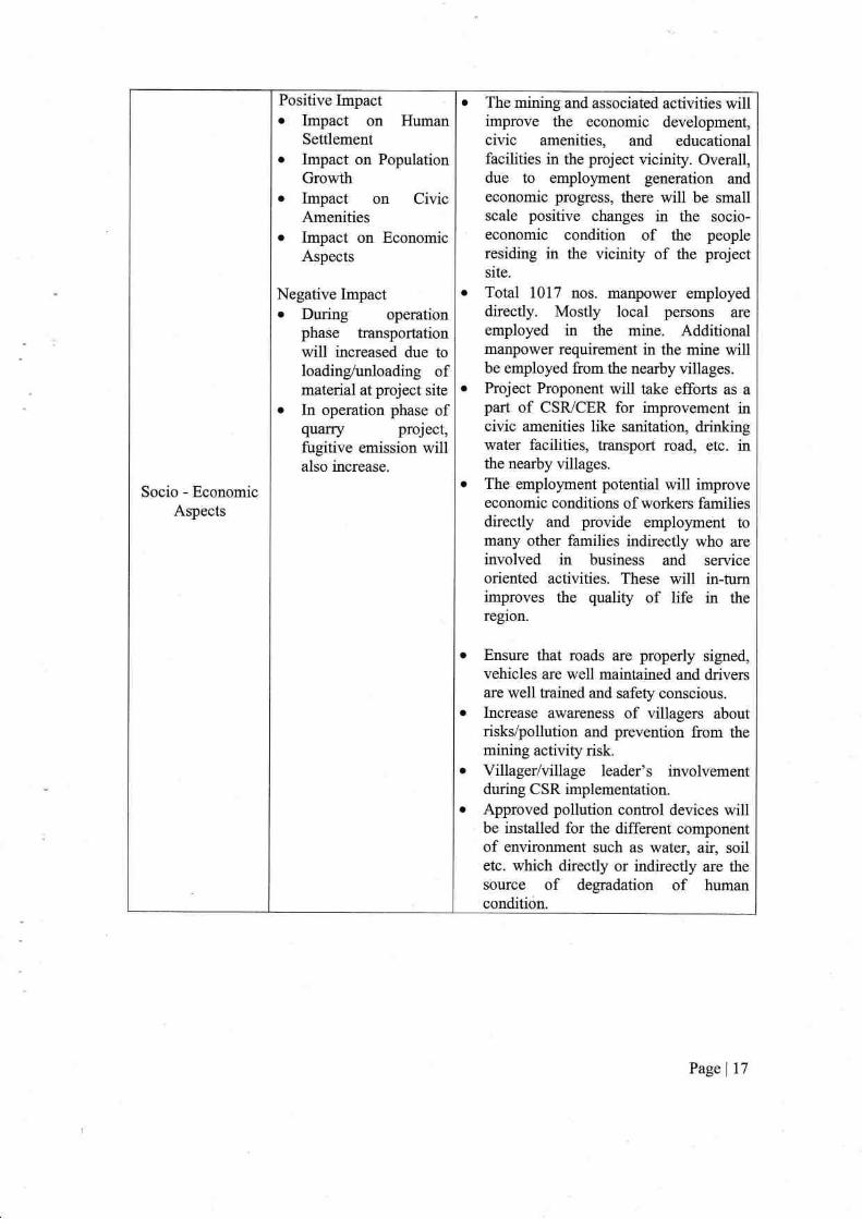
Socio - Economic
Aspects
Positive Impacto Impact on Human
Settlement
o Irnpact on Population
Growtho Impact on Civic
Amenitieso Impact on Economic
Aspects
Negative Impacto During operation
phase transportation
will increased due toloading/unloading ofmaterial at project site
o In operation phase ofquarry prdect,fugitive emission willalso increase.
The mining and associated activities willimprove the economic development,
civic amenities, and educational
facilities in the project vicinify. Overall,due to employnent generation and
economic progress, there will be smallscale positive changes in the socio-
economic condition of the people
residing in the vicinity of the project
site.
Total 1017 nos. manpower employeddirectly. Mostly local persons are
employed in the mine. Additionalmanpower requirement in the mine willbe employed from the nearby villages.
Project Proponent will take efforts as a
part of CSR/CER for improvement incivic amenities like sanitation, drinkingwater facilities, transport road, etc. inthe nearby villages.
The employment potential will improve
economic conditions of workers familiesdirectly and provide employment tomany other families indirectly who are
involved in business and service
oriented activities. These will in-turnimproves the quality of life in the
region.
Ensure that roads are properly signed,
vehicles are well maintained and driversare well trained and safety conscious.
Increase awareness of villagers about
risks/pollution and prevention from the
mining activity risk.
Villager/village leader's involvementduring CSR implementation.
Approved pollution control devices willbe installed for the different component
of environment such as water, air, soiletc. which directly or indirectly are the
source of degradation of human
conditi<in.
Page I 17

Occupational
Health&Safety
Exposure to dust can
results in Respiratory
problems.
Physical hazards:
Injuries duringProject operation are
typically related toslips and falls; contact
with falling / movingobjects; and lifting iover-exertion.
Injuries may occur
due to contact with,or capture in, movingmachinery (e.g.
dumpers).
Skict observance of the provisions ofDGMS Acts, Rules and Regulations inrespect of safety both by management
and the workers.
Proper planning and designing of workin order to reduce the risk ofhazards.
Specific instructions and supervisions ofworking where danger due to fall of side
(overhanging, undercutting of bench,
fall of objects from higher
benches/places, working at height isapprehended).
Training of work persons and the
officials.
The width of road will be maintained
more than thrice the width of the
vehicle. A code of traflic rules will be
implemented.
In respect of contract work, safety code
for contractors and workers will be
implemented. They will be allowed towork under skict supervision ofstatutory person/officials only after they
will impart training at vocational
training cenkes. All personal protective
equipment's will be provided to them.
A safety committee meeting everymonth will be organtzed to discuss the
safety of the mines and the persons
employed.
Celebration of annual mines safety weekand environmental week in order todevelop safety awareness amongst
employees.
Pre joining medical check-up shall be
done and regular health check-up in 6
monthly interval is planned for the
employees.
Periodical Medical Examination (PME)
of regular employees and contractual
workers will be conducted yearly.
Yearly Statutory training will be
provided comprising of Refresher, First-aid & Fire Fighting. Non-statutory
trainings about Cost Control, Skill &Efficiency Development, and QualityImprovements etc. will also be provided.
A first-aid room with ambulance is
made available.
Page | 18

5. EI\"VIROIIMENT MONITORING PROGRAMME -
Regular monitoring program for environmental parameters has been carried out and
compliance reports are submitted to Regional Office MoEF & CC. The objective of
monitoring is:
o To check or assess the efficiency of the controlling me:uures;
o To establish a data base for future impact assessment studies.
6. RISK ASSESSMENT & HAZARD *
The components associated with risk and hazard in this case include drilling &
blasting, spoil dump, heavy earth moving machinery and explosive storage. Measures to
reduce and avoid any incidents occurring from the above mentioned components are already
in place and shall continue to do the same as soon as the mine starts working. Proper risk
management plan is in place and shall be regularly monitored and maintained in order to
avoid any kind of untoward incident.
7. PROJECT BENEFITS _
Improvement in physical infrastructure
Improvement in Social Infrastructure
Employment Potential
Company will continue to undertake awareness program and community activities
like health camps, medical aid and family welfare camps
Greenbelt development.
8. EI\'VIRONMENT MANAGEMENT PLAI\ -
The Environmental Management Plan (EMP) is a site specific plan developed based
on the base line environmental status, mining methodology and environmental impact
assessment. The mine will be supervised and controlled by an independent Mines Manager
supported by adequate team of technically and statutorily qualified personnel apart from the
operating staff of skilled, semi-skilled, unskilled and other categories.
a
a
a
a
Page | 19

Arasu Magnesite Mines has formed its Environment Monitoring Cell which is
responsible for the management and implementation of the environmental control measures.
Basically, this deparbnent shall supervise the monitoring of environmental pollution levels
like ambient air quality, water and effluent qualrty, soil quality and noise level by appointing
approved external agencies.
The working conditions in the mines are govemed by the enactrnents of the
Directorate General of Mines Safety (DGMS). The management has taken all necessary
precautions regarding health and safety of workers as per the guidelines of The Mines Act.
Sanitary facilities are provided within the lease area and the management will continue to
carry out periodical health check-up for workers.
The company will also continue to take up development activities as part of CSR &
CER for overall development of the people in and around the area. The activities shall
include medical camps, water supply and improvement of school infrastructure. The
Company has been carrying out CSR Activities in various fields for social welfare around the
pmject site and spent an amount of Rs 335.39 Lalhs till date.
ENVIRONMENT MONITORING PROGRAM
The monitoring schedule along with monitoring parameters, monitoring frequencies
and duration is given in the below table -
SL
IYo,
EnviionmentI .,,*pett
: ,: ,
Action to be FollowedI'requency
Monitorinsi,tocation
1 Air Emissions Ambient air quality within
mioi.rg area and at the
nearby habitations.
PMro, PM25, SOr,
NO*.
Twice in a
weekin core
zone &seasonal
monitoring
being carried
out in core
zone and
buffer zone
once in season
One location
within mining
area &Two
location al
Sengaradu and
Thekkampatti
village
Exhaust from mining
machinery to be minimized
periodic maintenance
Vehicle logs tobe maintained
Quarteriy
Prohibition of overloading
and adoption of covered
transportation of stone
Vehicle logs Daily records Main gate
2 Noise Noise generated fromvarious mining operation
Spot Noise Level
recordinq:
Four times in ayear (Noise
One location
within minine
Page | 20
Parameters forMonitoring

st,No.
Frequency
ofMonitorins
like drilling/ blasting/
vehicular movement to be
optimized and monitored.
L"n(day),
L^^(nishO
level in dB (A)for day and
night time.
arca & Two
location at
Sengaradu and
Thekkampatti
village
Generation of vehicular
noise
Maintain records
ofvehicles
Periodic during
operation
phase
Mine working
area
J Wastewater
Discharge
No untreated discharge to
be made to surface water,
groundwater or soil.
Quality of run-off
water from
settling tank/pond
Periodic during
operation
phase
Garland drains,
settling ponds
4 Drainage and
effluent
Management
Ensure drainage system
and specific desigrr
measures are working
effectively.
Avoid disturbance to the
natural drainage of the
atea.
Visual inspection
of drainage and
records thereof
Periodic during
operation
phase
Surface run-off
from ML area
during rains.
Quality
discharge water,
if any.
5 Water Qualityand Water
Levels
Monitoring of used water
quality & groundwater
quality and levels
Comprehensive
water quality
monitoring as per
IS 10500
Depth of ground
water table
Once in a
quarter
Accumulated
water in mine
pit & ground
water
monitoring from
Mining area and
two location at
Sengaradu and
Thekkampatti
village
6 Emergency
preparedness,
such as fire
fighting
Fire protection and safety
measures to take care offire and explosion hazards,
to be assessed and steps
taken for their prevention.
Mock drill
records, on site
emergency plan,
evacuation plan
Periodic during
operation
phase
Explosive van,
mine machinery
7 Maintenance offlora and fauna
Vegetation, greenbelt Igreen cover development
No. of plants,
species, survival
rate
Periodic during
operation
phase
Greenbelt area
in mine.
8 Waste
Management
Implement waste
management plan and the
procedures for collection,
handling & disposal ofeach waste generated in the
mine.
Records of waste
generation,
treatment and
disposal
Periodic during
operation
phase
Mine lease area
9 Soil quality Conservation of top soil
excavated
Soil fertility, soil
contamination
Periodical
monitoring
Greenbelt area,
top soil area.
10 Health &
Safety
Employees and contractual
labour health check ups
Al1 relevant
parameters
respiration, x ray,
physical fitness,
eye check-up
including HIV
Regular clieck
ups
Mine workings
. Pagel2l
E-nviionment
Aspect .Action to be Followed
Parameters forMonitoring
Location

9. Conclusion -
It is concluded from overall assessment of the impacts, in terrns of positive and
negative effects on various environmental components and considering the fact that the
project area is subjected to mining for more than 80 years and have been implementing
effective environmental pollution conhol measures the mining operations will have limited
impact on the local environment and with effective implementation of the environment
management measures as suggested in the EIA/EMP report and as recommended by MoEF &
CCISEIAA, CPCB and State Pollution Control Board, the negative impacts will be
minimized to a great extent.
To mitigate any impact due to fhs mining activities, a well-planned EMP and a
detailed post project monitoring system is provided for continuous monitoring and immediate
rectification at site. Due to the mining activities, socio economic conditions in and around the
project site have improved substantially and demands continuation of this project.
Thus, in view of considerable benefits from the project, tire continuation of the project
is most advantageous to the surrounding villages, region as well as to the nation.
Page 122