Embed Size (px)
Citation preview
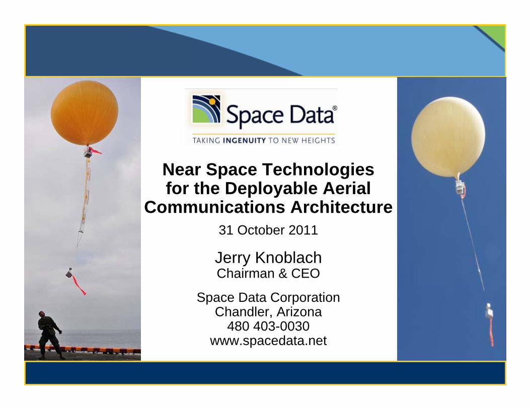
Near Space Technologies for the Deployable Aerial
Communications Architecture31 October 2011
Jerry KnoblachChairman & CEO
Space Data CorporationChandler, Arizona
480 403-0030www.spacedata.net
1Copyright Space Data Corp. 2011
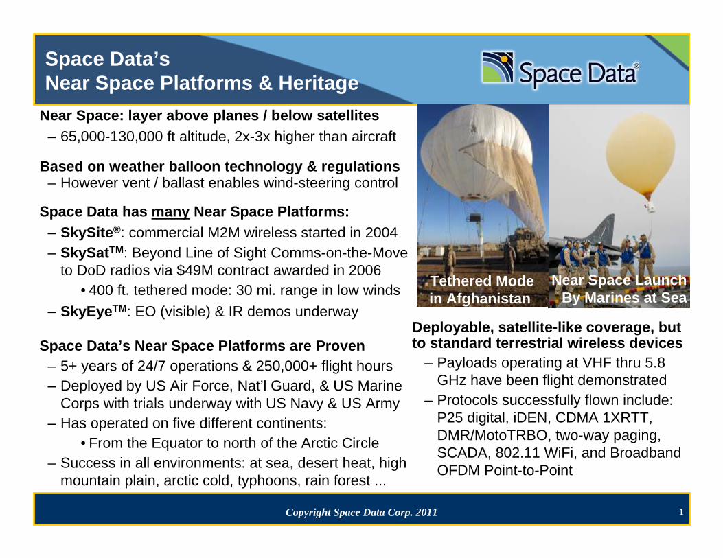
Space Data’s Near Space Platforms & Heritage
Near Space: layer above planes / below satellites– 65,000-130,000 ft altitude, 2x-3x higher than aircraft
Based on weather balloon technology & regulations– However vent / ballast enables wind-steering control
Space Data has many Near Space Platforms:– SkySite®: commercial M2M wireless started in 2004– SkySatTM: Beyond Line of Sight Comms-on-the-Move
to DoD radios via $49M contract awarded in 2006• 400 ft. tethered mode: 30 mi. range in low winds
– SkyEyeTM: EO (visible) & IR demos underway
Space Data’s Near Space Platforms are Proven– 5+ years of 24/7 operations & 250,000+ flight hours– Deployed by US Air Force, Nat’l Guard, & US Marine
Corps with trials underway with US Navy & US Army– Has operated on five different continents:
• From the Equator to north of the Arctic Circle– Success in all environments: at sea, desert heat, high
mountain plain, arctic cold, typhoons, rain forest ...
Deployable, satellite-like coverage, but to standard terrestrial wireless devices
– Payloads operating at VHF thru 5.8 GHz have been flight demonstrated
– Protocols successfully flown include: P25 digital, iDEN, CDMA 1XRTT, DMR/MotoTRBO, two-way paging, SCADA, 802.11 WiFi, and Broadband OFDM Point-to-Point
Near Space LaunchBy Marines at Sea
Tethered Modein Afghanistan
2Copyright Space Data Corp. 2011
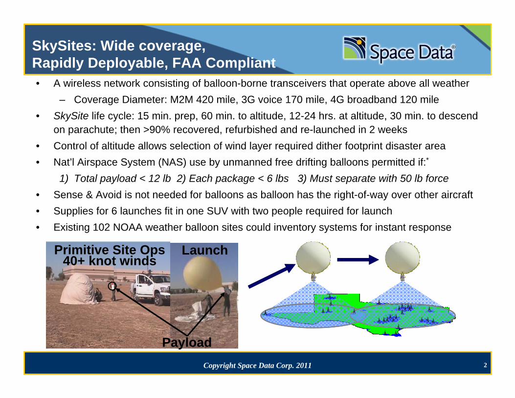
SkySites: Wide coverage, Rapidly Deployable, FAA Compliant• A wireless network consisting of balloon-borne transceivers that operate above all weather
– Coverage Diameter: M2M 420 mile, 3G voice 170 mile, 4G broadband 120 mile• SkySite life cycle: 15 min. prep, 60 min. to altitude, 12-24 hrs. at altitude, 30 min. to descend
on parachute; then >90% recovered, refurbished and re-launched in 2 weeks• Control of altitude allows selection of wind layer required dither footprint disaster area• Nat’l Airspace System (NAS) use by unmanned free drifting balloons permitted if:*
1) Total payload < 12 lb 2) Each package < 6 lbs 3) Must separate with 50 lb force• Sense & Avoid is not needed for balloons as balloon has the right-of-way over other aircraft • Supplies for 6 launches fit in one SUV with two people required for launch• Existing 102 NOAA weather balloon sites could inventory systems for instant response
LaunchPrimitive Site Ops40+ knot winds
Payload
3Copyright Space Data Corp. 2011
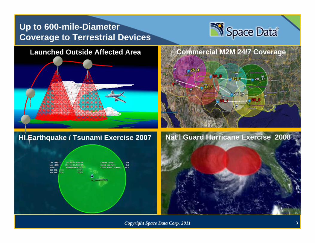
Up to 600-mile-DiameterCoverage to Terrestrial Devices
HI Earthquake / Tsunami Exercise 2007 Nat’l Guard Hurricane Exercise 2008
Commercial M2M 24/7 CoverageLaunched Outside Affected Area
4Copyright Space Data Corp. 2011
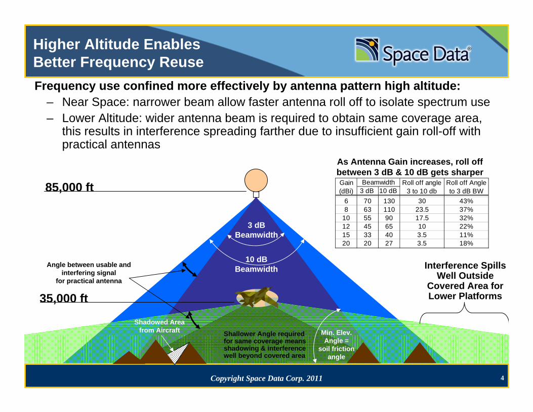
Higher Altitude EnablesBetter Frequency ReuseFrequency use confined more effectively by antenna pattern high altitude:
– Near Space: narrower beam allow faster antenna roll off to isolate spectrum use – Lower Altitude: wider antenna beam is required to obtain same coverage area,
this results in interference spreading farther due to insufficient gain roll-off with practical antennas
35,000 ft
85,000 ft
Interference Spills Well Outside
Covered Area for Lower Platforms
3 dB Beamwidth
10 dB Beamwidth
Min. Elev. Angle =
soil friction angle
Angle between usable and interfering signal
for practical antenna
Shallower Angle required for same coverage means shadowing & interference well beyond covered area
Shadowed Area from Aircraft
3 dB 10 dB 6 70 130 30 43%8 63 110 23.5 37%
10 55 90 17.5 32%12 45 65 10 22%15 33 40 3.5 11%20 20 27 3.5 18%
Roll off Angle to 3 dB BW
BeamwidthGain (dBi)
Roll off angle 3 to 10 db
As Antenna Gain increases, roll off between 3 dB & 10 dB gets sharper
5Copyright Space Data Corp. 2011
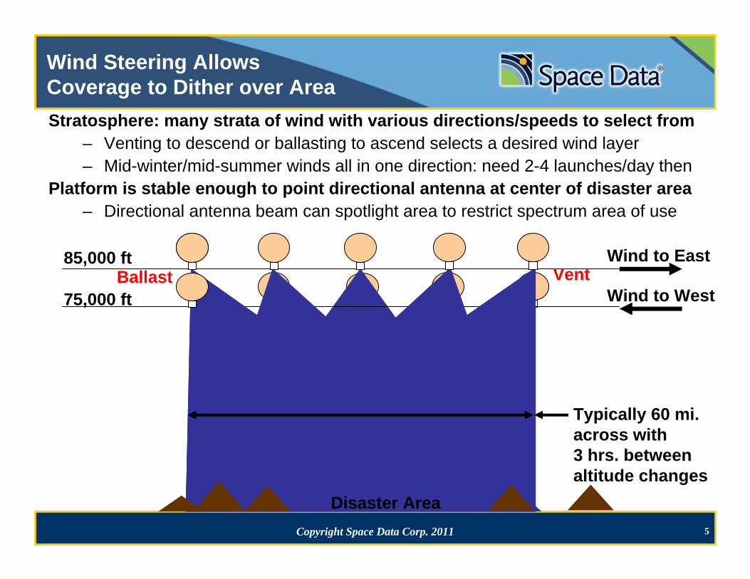
Wind Steering AllowsCoverage to Dither over AreaStratosphere: many strata of wind with various directions/speeds to select from
– Venting to descend or ballasting to ascend selects a desired wind layer– Mid-winter/mid-summer winds all in one direction: need 2-4 launches/day then
Platform is stable enough to point directional antenna at center of disaster area– Directional antenna beam can spotlight area to restrict spectrum area of use
75,000 ft
AntennaBeam width
points at center of disaster area
85,000 ftVent
Wind to West
Wind to East
Typically 60 mi. across with 3 hrs. betweenaltitude changes
Ballast
Disaster Area
6Copyright Space Data Corp. 2011
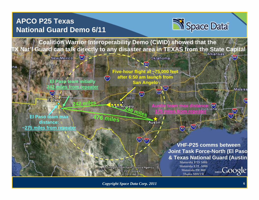
APCO P25 Texas National Guard Demo 6/11
El Paso team max distance:
~275 miles from repeater
El Paso team initially242 miles from repeater
Austin team max distance:175 miles from repeater
476 miles
246 miles
242 miles
VHF-P25 comms betweenJoint Task Force-North (El Paso& Texas National Guard (Austin)
Five-hour flight at ~75,000 feet after 6:50 am launch from
San Angelo
Motorola XTS 5000Motorola XTL 5000
Motorola PR 860Thales MBITR
Coalition Warrior Interoperability Demo (CWID) showed that the TX Nat’l Guard can talk directly to any disaster area in TEXAS from the State Capital
7Copyright Space Data Corp. 2011
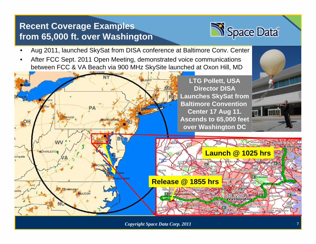
Recent Coverage Examplesfrom 65,000 ft. over Washington• Aug 2011, launched SkySat from DISA conference at Baltimore Conv. Center• After FCC Sept. 2011 Open Meeting, demonstrated voice communications
between FCC & VA Beach via 900 MHz SkySite launched at Oxon Hill, MD
Launch @ 1025 hrs
Release @ 1855 hrs
LTG Pollett, USADirector DISA
Launches SkySat fromBaltimore Convention
Center 17 Aug 11.Ascends to 65,000 feetover Washington DC
8Copyright Space Data Corp. 2011
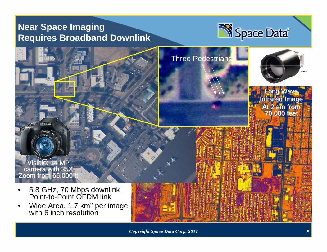
• 5.8 GHz, 70 Mbps downlink Point-to-Point OFDM link
• Wide Area, 1.7 km2 per image, with 6 inch resolution
Visible: 14 MP Visible: 14 MP camera with 35X camera with 35X
Zoom from 65,000 ftZoom from 65,000 ft
Near Space ImagingRequires Broadband Downlink
Three Pedestrians
Long Wave Long Wave Infrared ImageInfrared ImageAt 2 am from At 2 am from 70,000 feet70,000 feet
9Copyright Space Data Corp. 2011
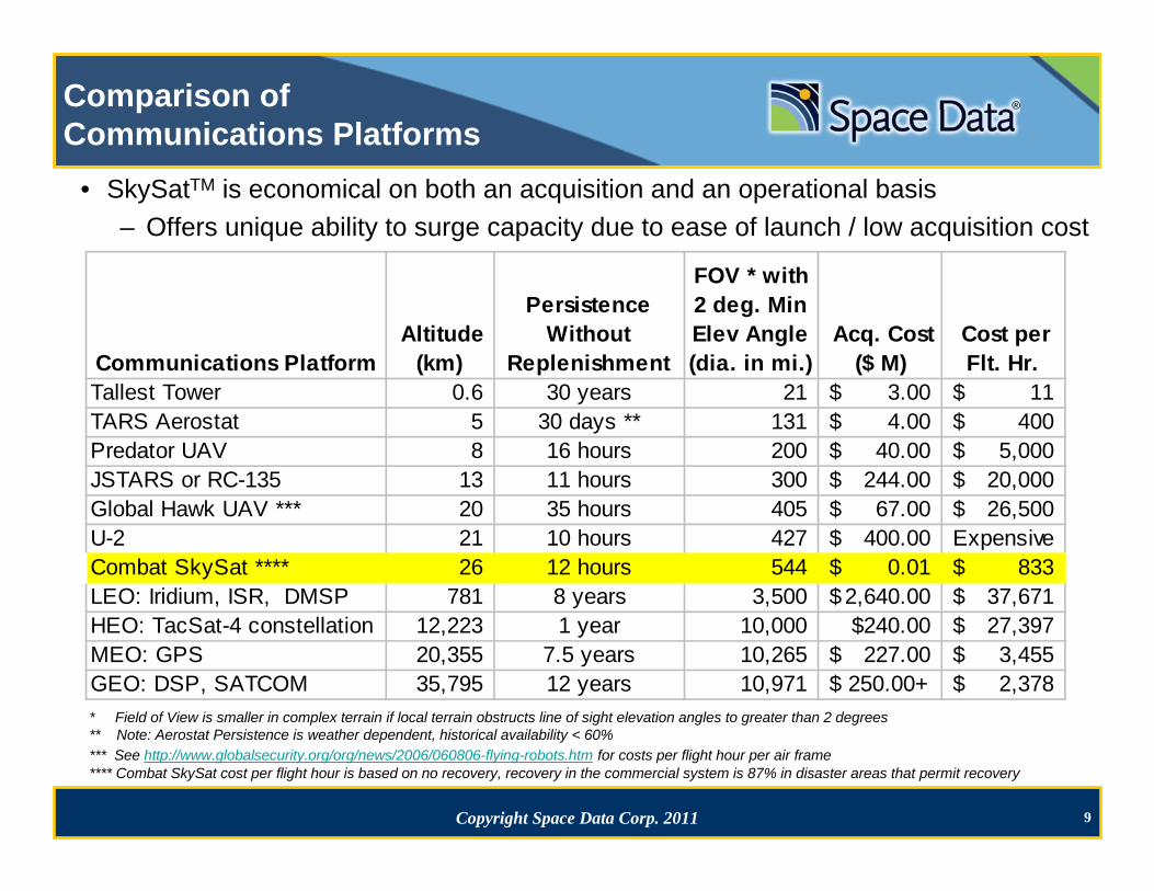
Comparison of Communications Platforms
Communications Platform Altitude
(km)
Persistence Without
Replenishment
FOV * with 2 deg. Min Elev Angle (dia. in mi.)
Acq. Cost ($ M)
Cost per Flt. Hr.
Tallest Tower 0.6 30 years 21 3.00$ 11$ TARS Aerostat 5 30 days ** 131 4.00$ 400$ Predator UAV 8 16 hours 200 40.00$ 5,000$ JSTARS or RC-135 13 11 hours 300 244.00$ 20,000$ Global Hawk UAV *** 20 35 hours 405 67.00$ 26,500$ U-2 21 10 hours 427 400.00$ ExpensiveCombat SkySat **** 26 12 hours 544 0.01$ 833$ LEO: Iridium, ISR, DMSP 781 8 years 3,500 2,640.00$ 37,671$ HEO: TacSat-4 constellation 12,223 1 year 10,000 $240.00 27,397$ MEO: GPS 20,355 7.5 years 10,265 227.00$ 3,455$ GEO: DSP, SATCOM 35,795 12 years 10,971 $ 250.00+ 2,378$ * Field of View is smaller in complex terrain if local terrain obstructs line of sight elevation angles to greater than 2 degrees** Note: Aerostat Persistence is weather dependent, historical availability < 60%*** See http://www.globalsecurity.org/org/news/2006/060806-flying-robots.htm for costs per flight hour per air frame**** Combat SkySat cost per flight hour is based on no recovery, recovery in the commercial system is 87% in disaster areas that permit recovery
• SkySatTM is economical on both an acquisition and an operational basis – Offers unique ability to surge capacity due to ease of launch / low acquisition cost
10Copyright Space Data Corp. 2011
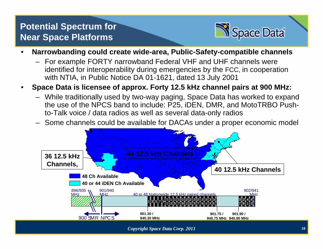
Potential Spectrum for Near Space Platforms
48 Ch Available40 or 44 iDEN Ch Available
44 12.5 kHz Channels36 12.5 kHzChannels,
40 12.5 kHz Channels
896/935 901/940 902/941 MHz MHz 40 to 48 Nationwide 12.5 kHz paired channels MHz
1234 910
11
12
13
14
15
16
17
18
900 SMR NPCS901.30 /940.30 MHz
5678 19
20
21
22
23
24
25
26
27
28
901.75 /940.75 MHz
901.90 /940.90 MHz
29
30
31
32
33
34
35
36
37
38
39
40
41
42
43
44
• Narrowbanding could create wide-area, Public-Safety-compatible channels– For example FORTY narrowband Federal VHF and UHF channels were
identified for interoperability during emergencies by the FCC, in cooperation with NTIA, in Public Notice DA 01-1621, dated 13 July 2001
• Space Data is licensee of approx. Forty 12.5 kHz channel pairs at 900 MHz:– While traditionally used by two-way paging, Space Data has worked to expand
the use of the NPCS band to include: P25, iDEN, DMR, and MotoTRBO Push-to-Talk voice / data radios as well as several data-only radios
– Some channels could be available for DACAs under a proper economic model
11Copyright Space Data Corp. 2011
Benefits of Space DataNear Space Platforms
• Compatible: terrestrial devices work like satellite devices, but with in-building coverage; no new device to buy, carry or learn
• Lower power: extends radio battery life of user devices• Responsive: prepare, launch and at altitude all within 2 hours• Rapidly deployable: air transportable in checked luggage• Simple logistics: open field launch in high wind w/ 2 people• No impact by poor access: deployed outside affected area• Secure: supports encrypted traffic as required• Interference controlled: pointing narrow beam antenna• Flexible: Demonstrated in multiple bands and protocols• All weather ops for Near Space, tethered in good weather• Military version in production now / deployed worldwide• Capacity/services increasing: macro→micro→pico→femto→

12
THANK YOU