Embed Size (px)
Citation preview

NNeebbrraasskkaa IInnnnoovvaattiioonn CCaammppuuss ((NNIICC))RReeddeevveellooppmmeenntt PPllaann
SSeepptteemmbbeerr 88,, 22001100
PPrreeppaarreedd bbyy::
City of Lincoln, NebraskaUrban Development DepartmentChris Beutler, Mayor
AApppprroovveedd bbyy PPllaannnniinngg CCoommmmiissssiioonn::October 6, 2010Amendment vote scheduled for 4/4/12
AApppprroovveedd bbyy CCiittyy CCoouunncciill:: November 8, 2010
Ammendment vote scheduled for 4/30/12
David Landis, DirectorUrban Development Department
Source: Nebraska Innovation Campus Master Plan,University of Nebraska-Lincoln, February 2010

i Nebraska Innovation Campus Redevelopment Plan
TTAABBLLEE OOFF CCOONNTTEENNTTSSIInnttrroodduuccttiioonn .. .. .. .. .. .. .. .. .. .. .. .. .. .. .. .. .. .. .. .. .. .. .. .. .. .. .. ..11
Plan Requirements . . . . . . . . . . . . . . . . . . . . . . . . . .2
EExxiissttiinngg CCoonnddiittiioonnss .. .. .. .. .. .. .. .. .. .. .. .. .. .. .. .. .. .. .. .. .. ..44Land Use . . . . . . . . . . . . . . . . . . . . . . . . . . . . . . . . . . .4Zoning . . . . . . . . . . . . . . . . . . . . . . . . . . . . . . . . . . . .6Parks/Open Space/Trails . . . . . . . . . . . . . . . . . . . . .7Transportation . . . . . . . . . . . . . . . . . . . . . . . . . . . . . .7
Traffic . . . . . . . . . . . . . . . . . . . . . . . . . . . . . . . . . . . . . . .7Street Conditions . . . . . . . . . . . . . . . . . . . . . . . . . . . . .8Parking . . . . . . . . . . . . . . . . . . . . . . . . . . . . . . . . . . . . . .8Sidewalks and Pedestrian Activity . . . . . . . . . . . . . .8Public Transportation Services . . . . . . . . . . . . . . . . .9
Public Utilities . . . . . . . . . . . . . . . . . . . . . . . . . . . . . . .9Water System . . . . . . . . . . . . . . . . . . . . . . . . . . . . . . . .9Sanitary Sewer System . . . . . . . . . . . . . . . . . . . . . . .10Watershed Management . . . . . . . . . . . . . . . . . . . .11Lincoln Electric System (LES) . . . . . . . . . . . . . . . . .12
Historic Significance . . . . . . . . . . . . . . . . . . . . . . . .12Blight & Substandard Determination Study . . .12Identified Issues . . . . . . . . . . . . . . . . . . . . . . . . . . . .14
For the NIC Area . . . . . . . . . . . . . . . . . . . . . . . . . . . .14
For the Theresa Street Area . . . . . . . . . . . . . . . . . .15
RReeddeevveellooppmmeenntt PPllaann .. .. .. .. .. .. .. .. .. .. .. .. .. .. .. .. .. .. ..1177Guiding Principles . . . . . . . . . . . . . . . . . . . . . . . . . .17
NICDC Updated Master Plan . . . . . . . . . . . . . . . . .18Theresa Street Area Guiding Principles . . . . . . . .19
NIC Area . . . . . . . . . . . . . . . . . . . . . . . . . . . . . . . . . .20Theresa Street Area . . . . . . . . . . . . . . . . . . . . . . . .26Sub-Project Areas . . . . . . . . . . . . . . . . . . . . . . . . . .27Future Land Use . . . . . . . . . . . . . . . . . . . . . . . . . . .27Redevelopment Processes . . . . . . . . . . . . . . . . . .27Estimated Expenditures . . . . . . . . . . . . . . . . . . . . .28Conformance with Comprehensive Plan . . . . .28Financing . . . . . . . . . . . . . . . . . . . . . . . . . . . . . . . . .28
LLiisstt ooff EExxhhiibbiittssExhibit 1: City Context Map . . . . . . . . . . . . . . . . . . . . . . .1Exhibit 2: Existing Land Use Map . . . . . . . . . . . . . . . . . .4Exhibit 3: Existing Building Inventory & Analysis . . . .6Exhibit 4: Existing Zoning Map . . . . . . . . . . . . . . . . . . . .7Exhibit 5: NIC Area Proposed Site Plan
at Full Build-Out . . . . . . . . . . . . . . . . . . . . . . . . . . . .20Exhibit 6: NIC Area Utilities at Full Build-Out . . . . . .21Exhibit 7: NIC Area Streets at Full Build-Out . . . . . . .21Exhibit 8: NIC Area Phase I . . . . . . . . . . . . . . . . . . . . . .22Exhibit 9: NIC Area Street Construction Phase I . . . .22Exhibit 10: NIC Area Water Phase I . . . . . . . . . . . . . . .23Exhibit 11: NIC Area Sanitary Sewer Phase I . . . . . . .23 Exhibit 12: NIC Area Storm Sewer Phase I . . . . . . . . .24Exhibit 13: NIC Area Demolition & Grading
Phase I . . . . . . . . . . . . . . . . . . . . . . . . . . . . . . . . . . . . .24Exhibit 14: NIC Area Power & Communication
Phase 1 . . . . . . . . . . . . . . . . . . . . . . . . . . . . . . . . . . . .25Exhibit 15: 4-H Companion Building . . . . . . . . . . . . .25Exhibit 16: 4-H and Companion Buildings . . . . . . . . .25Exhibit 17: Life Science Building . . . . . . . . . . . . . . . . . .26Exhibit 18: Industrial Arts & Life Science Building . .26Exhibit 19: Future Land Use . . . . . . . . . . . . . . . . . . . . .27
LLiisstt ooff AAppppeennddiicceessAppendix A: Properties to be Acquired . . . . . . . . . . . .30Appendix B: NIC Phase I Cost Benefit Analysis . . . . .31

IINNTTRROODDUUCCTTIIOONNThe Nebraska Innovation Campus (NIC) Redevelop-ment Plan is a guide for redevelopment activitieswithin the Redevelopment Area. Exhibit 1 illustratesthe location of the area within the broader context ofthe City of Lincoln. The Redevelopment Area is com-prised of two parts: the area adjacent to theUniversity of Nebraska-Lincoln (UNL) city campus thatincludes the former Nebraska State Fair Park, nowknown as Nebraska Innovation Campus (NIC Area),and the area north of NIC that includes the City’sTheresa Street Waste Water Treatment Facility, indus-trial/commercial uses, and mobile home parks (theTheresa Street Area].
The boundaries of the NIC Area are generally from14th to 27th Streets, between Salt Creek and theBurlington Northern Santa Fe Railroad corridors, alsodescribed as an area within the City of Lincoln,Nebraska, that includes all portions of Irregular Lots14, 15, 45, 69, 71, 72, 73, 74, 75, 79, 80, 104, and 167;said irregular tracts located in Section 13-T10N-R6E ofthe 6th Principle Meridian, except Antelope Valley FirstAddition.
The boundaries of the Theresa Street Area are gener-ally between Cornhusker Highway and Salt CreekRoadway, at its intersection with North 27th Street,from approximately North 20th Street at the west
boundary to North 27th Street at the east boundary,also described as an area within the City of Lincoln,Nebraska, that includes all portions of the Carroll M5Addition, Kimco Industrial Park, Kimco Industrial Park2nd Addition and Kimco Industrial park 3rd Addition;and Irregular Tracts 82 NE (ex. E 17’); 108 NE (ex. E.Pt. For Road); 153 NE (ex. N. 7.5’ for road andIrregular Tract Lot169 ex. N. Pts. For road NE); 155 NE(ex. E Pt. For street); 190 NE (ex. E. 27’); and 191 NE,196 NE, 201 NE, 202 NE, 204 NE, 205 NE; 207 NE Cityof Lincoln parcels associated with the Theresa StreetWastewater Facilities, including 105 NE, 115 NE and168 NE and adjacent area up to the center line of theSalt Creek Channel; and public Rights-of-Way withinthe Redevelopment Area Boundaries, includingCleveland Avenue, Theresa street, Kimco Circle, KimcoDrive, Kimarra Place, Cornhusker Highway and North27th Street.
In 2008, the Nebraska State Legislature approved, andthe Governor signed into law, LB116 which relocatedthe Nebraska State Fair to Grand Island and trans-ferred the former Nebraska State Fairgrounds to theUniversity of Nebraska Board of Regents. The legisla-tion required that UNL provide a Master Plan andBusiness Development Strategy to the Legislature byDecember 1, 2009. Both reports were completed.The Board of Regents approved the NebraskaInnovation Master Plan and Nebraska InnovationCampus Business Development Strategy on November20, 2009. The transfer of ownership of the 249 acreproperty occurred in December, 2009.
Now known as Nebraska Innovation Campus, NIC is apublic/private partnership and research park dedi-cated to advancing research and its commercializationin order to generate economic growth for Nebraska.It is envisioned that one of the primary attractions toNIC will be the opportunity for private sector compa-nies to become an intimate partners with UNL and tolocate adjacent to University research facilities and fac-ulties. According to the University’s Request forInformation (RFI) issued July 11, 2008:
“The purpose of Nebraska Innovation Campus(NIC) is to create partnerships with private sec-tor firms to develop and maximize economicopportunities and to leverage the researchcapacity, faculty and student resources of theUniversity of Nebraska-Lincoln. This will beaccomplished by attracting private sector com-panies with existing or proposed relationshipswith the University to locate adjacent to theuniversity campus and facilities and therebygenerate jobs and other economic activity for
Exhibit 1: City Context Map
Nebraska Innovation Campus Redevelopment Plan 1NNeebbrraasskkaa IInnnnoovvaattiioonn CCaammppuuss RReeddeevveellooppmmeenntt PPllaann 11
44 NNeebbrraasskkaa IInnnnoovvaattiioonn CCaammppuuss RReeddeevveellooppmmeenntt PPllaann22 NNeebbrraasskkaa IInnnnoovvaattiioonn CCaammppuuss RReeddeevveellooppmmeenntt PPllaann
and lay the foundation for the additional private R&Danticipated in the corridor. The City has made zoningchanges and instituted design standards to lay thefoundation for, and encourage, private developmentin the R&D corridor outside the limits of NIC.
The Nebraska State Fair was located in Lincoln in1901. During its 100 year operation at this location,buildings have become deteriorated or dilapidatedand infrastructure - including streets, sidewalks andutilities (sewer and water) have become inadequateby modern standards for redevelopment.
As a result of these conditions, UNL requested thecompletion of a Blight and SubstandardDetermination Study. The Study, completed inOctober 2009 concluded that the number, degree,and distribution of blighting factors warrant designat-ing the area blighted and substandard. As planningproceeded for NIC, discussions between Nova (theNIC developer) and City determined it would be mutu-ally beneficial to expand the NIC boundary north andexchange land owned by the Board of Regents forCity-owned land. During these discussions, it was rec-ognized that the area immediately north of NIC andadjacent to the City’s Theresa Street WastewaterTreatment Plant has also experienced decline. Furtherassessment of the area north to Cornhusker and eastto 27th Street revealed deteriorating conditions. As aresult, the Theresa Street Redevelopment Area Blightand Substandard Determination Study was completedby the developer in January, 2012. This study alsoconcluded that the number, degree, and distributionof blighting factors warrant designating the areablighted and substandard.
The City recognizes that continuing blight and deteri-oration is a threat to the stability and vitality of thearea and revitalization efforts cannot reasonably occurwithout public action. The Nebraska InnovationCampus (NIC) Redevelopment Plan represents theCity’s efforts to assist UNL in guiding public and pri-vate redevelopment and to guide revitalization of theTheresa Street Area.
PPllaann RReeqquuiirreemmeennttss Redevelopment activities are guided by CommunityDevelopment Law, Neb. Rev. Stat., Section 18-2101, et.seq. (as amended). The statutes clearly state that thegoverning body must first declare the project areasubstandard and blighted in order to prepare a rede-velopment plan.
The City has authorized its Urban DevelopmentDepartment to act as the redevelopment authorityunder the applicable Law. The Urban DevelopmentDepartment has formulated, for the City of Lincoln, a
the state of Nebraska. Agricultural biotechnol-ogy and life science research are anticipated tobe strong components of the campus. Otherareas of university research strength that pro-vide opportunities for viable partnershipsinclude food science and food safety, robotics,computer technology, laser sciences, trans-portation, energy sciences, and alterativeenergy.
The Board of Regents created the NebraskaInnovation Campus Development Corporation(NICDC), a non-profit corporation charged with devel-opment of NIC and day-to-day operations. AnExecutive Director has been hired and a Board ofDirectors created comprised of five private-sectormembers and four University representatives. A seven-member Advisory Committee comprised of Universityprofessors monitors programming and property devel-opments, evaluates related interests of the private andpublic sectors, interfaces with University colleagues forideas and opportunities, and advises the board ofdirectors as necessary. The vision statement devel-oped by the NICDC for NIC is: “A dynamic environ-ment where university and private sector talent trans-form ideas into innovation that impacts the world”(NIC website). The NICDC issued a request for propos-als to select a developer and in June, 2011 selectedNebraska Nova Development L.L.C. (Nova) for the firstphase of development. In February 2012, NICDC com-pleted a Strategic Planning Report and updated mas-ter plan.
NIC is located at the northern edge of the AntelopeValley Project’s Research and Development (R&D) cor-ridor. The Antelope Valley Project is sponsored bythree partners: the City of Lincoln, Lower Platte SouthNatural Resources District, and the University ofNebraska-Lincoln. Its purpose is to address flood con-trol, transportation improvements and communityrevitalization in the core of the city. The R&D corridoris generally located between K Street on the South,Innovation Campus on the north, 16th Street on thewest and 21st Street (the Antelope Valley waterway)on the east.
In 2007, the 2015 Vision Group proposed the devel-opment of a R&D corridor which would link UNL’spublic research and development facilities to potentialand planned private research and development facili-ties to the north and south, adjacent to the AntelopeValley waterway. At that time, the State Legislaturewas studying the future of State Fair Park and thepotential development of a university R&D technologypark. With the Legislature’s action in 2008, the City ofLincoln considers NIC a critical partner for theAntelope Valley R&D corridor that will compliment

NNeebbrraasskkaa IInnnnoovvaattiioonn CCaammppuuss RReeddeevveellooppmmeenntt PPllaann 5555 NNeebbrraasskkaa IInnnnoovvaattiioonn CCaammppuuss RReeddeevveellooppmmeenntt PPllaannNNeebbrraasskkaa IInnnnoovvaattiioonn CCaammppuuss RReeddeevveellooppmmeenntt PPllaann 33
workable program utilizing appropriate private andpublic resources to,
• eliminate or prevent the development or spreadof urban blight;
• encourage needed urban rehabilitation;
• provide for the redevelopment of substandardand blighted areas including provision for theprevention of the spread of blight into areas ofthe municipality which are free from blightthrough diligent enforcement of housing, zoning,and occupancy controls and standards;
• the rehabilitation or conservation of substandardand blighted areas or portions thereof by re-plan-ning, removing congestion, providing parks, play-grounds, and other public improvements byencouraging voluntary rehabilitation and by com-pelling the repair and rehabilitation of deterio-rated or deteriorating structures; and,
• clear and redevelop substandard and blightedareas or portions thereof.
The Community Development Law section 18-2111defines the minimum requirements of a redevelop-ment plan as follows:
“A redevelopment plan shall be sufficiently com-plete to indicate its relationship to definite localobjectives as to appropriate land uses, improvedtraffic, public transportation, public utilities,recreational and community facilities and otherpublic improvements, and the proposed landuses and building requirements in the redevel-opment project areas...”
The statutes further identify six elements that, at aminimum, must be included in the redevelopmentplan, they are:
1. The boundaries of the redevelopment projectarea with a map showing the existing uses andcondition of the real property area;
2. A land-use plan showing proposed uses of thearea;
3. Information showing the standards of populationdensities, land coverage, and building intensitiesin the area after redevelopment;
4. A statement of the proposed changes, if any, inzoning ordinances or maps, street layouts, streetlevels or grades, or building codes and ordi-nances;
5. A site plan of the area;
6. A statement as to the kind and number of addi-tional public facilities or utilities which will berequired to support the new land uses in the areaafter redevelopment.
In making its recommendation to approve this plan,the Urban Development Department has consideredthe land uses and building requirements and deter-mined that they are in conformance with the generalplan for redevelopment in the city and represent acoordinated, adjusted, and harmonious developmentof the city and its environs. These determinations arein accordance with:
• present and future needs to promote health,safety, morals, order, convenience, prosperity;
• the general welfare; and
• efficiency and economy in the process of devel-opment.
Factors considered in the determination includedamong other things:
• adequate provision for traffic, vehicular parking;
• the promotion of safety from fire, panic, andother dangers;
• adequate provision for light and air;
• the promotion of the healthful and convenientdistribution of population;
• the provision of adequate transportation, water,sewerage, and other public utilities;
• schools, parks, recreational and community facili-ties, and other public requirements;
• the promotion of sound design and arrange-ment;
• the wise and efficient expenditure of publicfunds; and
• the prevention of the recurrence of insanitary orunsafe dwelling accommodations or conditionsof blight.
The development of the Redevelopment Plan reliesheavily upon, and draws from, previous work includ-ing the State Fair Park Redevelopment Area Blight andSubstandard Determination Study, October 2009 andthe Nebraska Innovation Campus Master Plan,February 8, 2010. Throughout the remainder of theRedevelopment Plan, the terms Redevelopment Area,State Fair Park, and Nebraska Innovation Campus(NIC) are used interchangeably to refer to the samegeographic area.
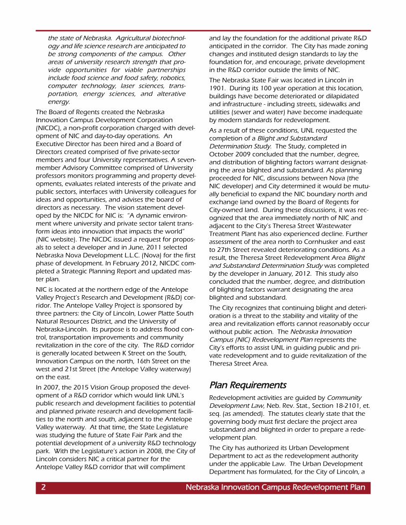
LLaanndd UUsseeMajor land uses in the NIC Area (see Exhibit 2) arepublic/quasi-public land uses and unimproved parkingareas (gravel surfaced roads within grass/dirt surfacedparking areas). The area contains approximately 249acres, not including the Rights-of-Way (ROW) of SaltCreek, Oak Creek and Antelope Creek. Public land
uses occupy approximately 76.3% of theRedevelopment Area. Approximately 23.7% of thearea consists of unimproved parking areas that aregrass/dirt surfaced with crushed white rock roadsbetween parking areas.
Railroads and the Salt Creek Roadway form the southboundary of the NIC Area. In addition, residential
EEXXIISSTTIINNGG CCOONNDDIITTIIOONNSS
Exhibit 2: Existing Land Use
44 NNeebbrraasskkaa IInnnnoovvaattiioonn CCaammppuuss RReeddeevveellooppmmeenntt PPllaann
**
*Area boundaries are approximations

NNeebbrraasskkaa IInnnnoovvaattiioonn CCaammppuuss RReeddeevveellooppmmeenntt PPllaann 7777 NNeebbrraasskkaa IInnnnoovvaattiioonn CCaammppuuss RReeddeevveellooppmmeenntt PPllaann
The Blight and Substandard Determination Studyincluded an analysis of lot layout in relation to size, ade-quacy, accessibility or usefulness and identified a pri-mary issue as inadequate lot size.
NIC is comprised of a variety of individual parcels ofland, both large and small, that have existed as irregu-lar tracts since 1872. Thirteen (13) irregular tractscomprise the entire Redevel-opment Area. None ofthe tracts were ever platted and developed accordingto the Subdivision Regulations of Lincoln/LancasterCounty. Several irregular tracts have no access tostreets and are land locked. As such, these tracts ofland do not meet today’s standards of platting andsubdivision procedures.
Efforts to overcome problems of improper subdivisionand obsolete platting and to secure sites of reasonablyadequate size and shape for modern development pur-poses requires the re-platting of irregular shapedparcels. Future development should be based on abroader scale, including larger areas of theRedevelopment Area, rather than the piecemeal devel-opment of smaller, single and multiple individual lotsthat has occurred in the past.
In the Theresa Street Area, there are 126 buildings on140 parcels of land. The Blight and SubstandardDetermination Study identified 84 structures (66.7%) aseither deteriorating or dilapidated to a substandard con-dition and 71% of the parcels as having “fair” or “poor”overall site conditions.
The primary issue in the Theresa Street Area identified inthe Blight and Substandard Determination Study is thatthe majority of parcels were developed as IrregularTracts, identified by metes and bounds descriptions.With the exception of the Kimco Industrial Park and theCarroll M5 Subdivisions, the area was incrementally sub-divided with irregular tracts of land. Existing businesseseither purchased a portion or an entire irregular tract.None of the commercial areas in the eastern portion ofthe area adhered to a planned subdivision process. Forexample, as parcels along Theresa Street and North 27thStreet developed, several businesses combined twotracts into one lot of record, while individual widths oflots were increased or decreased to support develop-ment needs. None of the lots are of uniform width orlength. The inadequacies in the development of landwith irregular tracts are most evident in the lack of acces-sibility to individual parcels and results in poor circulationpatterns throughout the entire area. For example,northbound traffic on North 27th street and eastboundtraffic on Cornhusker Highway access businesses at thesouthwest corner of the intersection by being directedby signage to Cleveland Street. Traffic accesses the busi-nesses via a private street located within “Outlot A,”
uses in the Clinton neighborhood lie to the south.Industrial and institutional uses are located south ofthe NIC Area along the east side of Antelope ValleyParkway. The west side is bounded by AntelopeValley Parkway, UNL transportation facilities, theNebraska National Guard and residential uses in theNorth Bottoms neighborhood.
Major land uses in the Theresa Street RedevelopmentArea (see Exhibit 2) are primarily mobile home resi-dential, commercial and public/quasi-public landsassociated with the Theresa Street Waste WaterTreatment Facility. The southeastern area is boundedby light industrial land uses with some also locatedalong Cornhusker Highway to the north. The areacontains an estimated 114 acres of which 83% hasbeen developed. The City’s Theresa Street WasteWater Treatment Facility occupies the western two-thirds of the area. A linear strip of open space at thenortheast portion of the facility property accommo-dates a hiker/biker trail connection from Salt Creek toTheresa Street. Vacant lands are concentrated at thesouthwestern portion of the property, abutting NIC.Mobile home parks occupy land between the treat-ment facility and various commercial and industrialuses at the eastern edge of the area, along the westside of North 27th Street.
There were approximately 70 structures in the NICArea, consisting primarily of barns and sheds used forthe State Fair. As part of the first phase of redevelop-ment, UNL demolished many of these structures.Others will require demolition before the site is redevel-oped. The Blight and Substandard Determination Studyidentified approximately 56% of structures surveyed aseither deteriorating or dilapidated. Also as part of thefirst phase of redevelopment, a few Heritage Educationbuildings have been relocated to other sites.
The Devaney Sports Center is currently used for uni-versity athletics programs including swimming, trackand field, men’s gymnastics, wrestling, men’s andwomen’s basketball and other events. The UNLAthletics Department is planning future expansions ofthe Devaney Center for the above mentioned programs,and it will remain on campus in its current use. TheColiseum, commonly known as the Ice Box, is leasedthrough 2031 by the Lincoln Stars, a minor leaguehockey franchise. The NIC Master Plan recommendedthat the structure be replaced when the lease terminateswith either research or related mixed use development.
The horse racing track and associated service facilitiesare currently leased by the Horsemen’s Benevolent &Protective Association (HBPA). These facilities will con-tinue to be used by HBPA throughout September 30,2012. See Exhibit 3, NIC Area Existing BuildingInventory & Analysis (Master Plan, p. 13).
NNeebbrraasskkaa IInnnnoovvaattiioonn CCaammppuuss RReeddeevveellooppmmeenntt PPllaann 55

88 NNeebbrraasskkaa IInnnnoovvaattiioonn CCaammppuuss RReeddeevveellooppmmeenntt PPllaann
space with a mix of uses onthe site of the old StateFairgrounds.
PP PPuubblliicc UUssee DDiissttrriicctt – Thisdistrict is intended to providea district essentially for map-ping purposes which willidentify real propertypresently owned and used byany government entity,including local, state, or fed-eral governmental units, andput to some form of publicuse. This district is notintended to be applied toland that is used by govern-mental entities on an ease-ment or leased basis if title tothe land is in private owner-ship.
HH--33 HHiigghhwwaayy CCoommmmeerrcciiaallDDiissttrriicctt – This is a district for aredeveloping area intendedto provide for low-densitycommercial uses requiringhigh visibility and/or accessfrom major highways. Theuses permitted generallyinclude those of the neigh-borhood and highway busi-ness areas.
II--11 IInndduussttrriiaall DDiissttrriicctt - this district is for a developingstable or redeveloping area representing light andheavy industrial uses and having a relatively highintensity of use and land coverage.
Re-zoning may be required as redevelopment occursin the Theresa Street Area.
PPaarrkkss//OOppeenn SSppaaccee//TTrraaiillssNo city parks are located within NIC. While there is aconsiderable amount of undeveloped land, its usageconsists primarily of grass and dirt surfaced parkingareas. Approximately 23.7% of the NIC Area consists ofunimproved parking areas that are connected bycrushed white-rock roads. This use is not typically con-sidered open space as compared to desirable green,aesthetically pleasing public open space.
With the completion of the Antelope Valley project, sev-eral bike trails converge in downtown and to the UNLCity Campus. The project included the completion oftrails along both sides of the Antelope Valley waterwayinto NIC. The trail on the east side of the creek termi-
88 NNeebbrraasskkaa IInnnnoovvaattiioonn CCaammppuuss RReeddeevveellooppmmeenntt PPllaann
which also leads traffic to Cornhusker Highway via theSuper 8 Motel parking lot.
ZZoonniinnggExhibit 4 identifies existing zoning districts within theRedevelopment Area. The NIC Area is comprised of O-3 PUD Office Park District with a smaller area of P,Public Use District.
A significant portion of the Theresa Street Area iszoned P, Public Use District. I-1, Industrial District, islocated to the west of the public land and includes themobile home parks. Land adjacent to North 27thStreet and Cornhusker Highway is primarily H-3,Highway Commercial.
The zoning districts within the area are as follows:
OO--33 PPUUDD OOffffiiccee PPaarrkk DDiissttrriicctt wwiitthh aann aapppprroovveeddPPllaannnneedd UUnniitt DDeevveellooppmmeenntt ((PPUUDD)) -- This district wasapproved by the City Council in November 2010 asChange Zone #10018. The PUD established specificregulations and waivers for the site as part of an over-all approval of two million square feet of commercial
66 NNeebbrraasskkaa IInnnnoovvaattiioonn CCaammppuuss RReeddeevveellooppmmeenntt PPllaann
Exhibit 3: NIC Area Existing Building Inventory & Analysis
Source: Nebraska Innovation Campus Master Plan, University of Nebraska-Lincoln, February 2010

NNeebbrraasskkaa IInnnnoovvaattiioonn CCaammppuuss RReeddeevveellooppmmeenntt PPllaann 9999 NNeebbrraasskkaa IInnnnoovvaattiioonn CCaammppuuss RReeddeevveellooppmmeenntt PPllaann
TTrraannssppoorrttaattiioonn� TTrraaffffiiccNIC is bordered by the newly con-structed Salt Valley Roadway andAntelope Valley Parkway, both ofwhich are four lane roadways.There are existing traffic signals atAntelope Valley Parkway andMilitary Road, a major entrance tothe site, and Antelope ValleyParkway and Salt Valley Roadway.Individual land uses at NIC andassociated vehicular trip genera-tion will allow assessment of theimpact on the surrounding trans-portation network.
A traffic impact study conductedfor the NIC Master Plan anticipatesNIC to generate up to 21,815daily trips at full build-out by 2030.The existing roadway system willhandle both future backgroundtraffic and additional traffic gener-ated by the build-out of NIC atdesirable levels of service. Theexception is the elevated intersec-tion of Antelope Valley Parkwayand Salt Valley Roadway, antici-pated to be at level of service Dand E in peak hours by 2030.However, any changes to the pro-posed land uses that were identi-fied in the traffic impact study willrequire a revised traffic impact
study which could result in additional improvement tothe transportation network.
The main entrance into NIC is located on AntelopeValley Parkway at Military Road. There are threeaccess points from Salt Creek Roadway into NIC; cur-rently two are gated and the intersection withMcFarland (eastern most intersection) is open andactively in use. Any modifications to the access pointsin location are subject to review and approval of thecity, state, and federal governments as required. TheCity will not approve any additional access locations.Any change in existing locations will require quartermile spacing. All costs associated with the reconstruc-tion of access locations and associated traffic controlshall be the responsibility of NIC.
An area of concern is the intensity of potential devel-opment east of Antelope Valley Parkway, north of SaltCreek and related access desires or needs. AntelopeValley Parkway to the Cornhusker ramp is four lanes
nates at Court Street south of Devaney and the trail onthe west side of the creek follows Antelope ValleyParkway along the entire length of the west side of NIC.The bike and pedestrian systems in the NIC Master Planrecommend connections to these existing facilities.
There are no city parks in the Theresa Street Area. TheInnovation Campus Connector Trail is proposed to thetrails system: travelling along the eastern boundary ofNIC, proceeding north and then along the easternedge of the Waste Water Treatment Plant property andconnecting to the existing trail that continues north toCornhusker. There is an existing trail from TheresaStreet to Cornhusker Highway east of the TheresaStreet Wastewater Plant. Plans also call for constructionof the Dietrich Connector Trail connecting alongTheresa Street to the east to the existing 27th Street trailthat goes south from the north side of the bridge overthe railroad tracks and then connects with the DietrichTrail at that point.
Exhibit 4: Existing Zoning
NNeebbrraasskkaa IInnnnoovvaattiioonn CCaammppuuss RReeddeevveellooppmmeenntt PPllaann 77

1100 NNeebbrraasskkaa IInnnnoovvaattiioonn CCaammppuuss RReeddeevveellooppmmeenntt PPllaann1100 NNeebbrraasskkaa IInnnnoovvaattiioonn CCaammppuuss RReeddeevveellooppmmeenntt PPllaann88 NNeebbrraasskkaa IInnnnoovvaattiioonn CCaammppuuss RReeddeevveellooppmmeenntt PPllaann
but concern is due to the close proximity of theCornhusker Highway ramp. Additionally, if the accesspoints at private streets or driveways are provided fullaccess, design standards require dedication of stubROW at those locations.
The primary streets in the Theresa Street Area includeTheresa Street, Cornhusker Highway and North 27thStreet. The nature of development patterns alongCornhusker Highway and North 27th Street, alongwith the lack of interior streets, has created poorvehicular circulation and accessibility issues.Northbound traffic on North 27th and eastbound traf-fic on Cornhusker Highway have limited access to thebusinesses near the intersection of these two streets.The Super 8 Motel, for example, has signage thatdirects east and northbound traffic to turn ontoCleveland Street and then access the motel via a pri-vate street in a platted outlot. Limited accessibility isalso evident with the mobile home parks and sanitarysewer treatment facility being accessed by one entrypoint from Theresa Street. If Theresa Street were tobecome blocked for any reason, the mobile homeparks and the treatment facility would become inac-cessible.
� SSttrreeeett CCoonnddiittiioonnssRoadways within NIC are not in dedicated ROW andare not presently maintained by the City. The pri-vately owned street network consists of a modifiedrectilinear grid system. The field survey conducted aspart of the Blight and Substandard DeterminationStudy rated the majority of the streets in theRedevelopment Area as “fair” to “poor” in condition.Approximately 38 (54.3%) of the 70 parcels can beaccessed by streets, or front on portions of a street in“fair” to “poor” condition. Several examples existthroughout the area where portions or segments ofstreets are resurfaced or repaved. Many other exam-ples are evident where only half or two-thirds of thewidth of the street is resurfaced or patched. In otherinstances, the entire width of a street is only repairedalong half of the length of the block, leaving the otherhalf of the block in substandard condition.
The portion of the Theresa Street Area comprised ofmobile home parks has privately owned streets thataccess the individual mobile homes. The Blight andSubstandard Determination Study identified privatestreets as “deteriorating.”These streets lack standardconcrete curbs, gutters and, in some cases, stormwater drainage ditches. As a result, storm waterlingers within the area and pools in low lying areas onstreets and in properties throughout the mobile homeparks.
� PPaarrkkiinnggThe Blight and Substantial Determination Study identi-fied inadequate parking conditions throughout theNIC Area. Surface parking areas of rock, grass anddirt are present in eight different areas, accounting fornearly 60 acres of the Redevelopment Area.
The Master Plan notes that the area currently accom-modates 4,400 on-site parking spaces in surface lotsand along roadways, used by patrons of the Ice Boxand events at Devaney. Additional parking lotsowned by UNL are within a 10 minute walk of NIC.
The Blight and Substandard Determination Studyidentified parking lots in the Theresa Street Area as“deteriorating.” The field study conducted for theBlight Study also identified inadequate parking condi-tions. Residents will occasionally park at the edge ofthe privately owned streets, or onto the front yardsadjacent to the mobile homes. For example, residentspark their automobiles diagonally and perpendicularto the side of the street or on the grass adjacent to themobile home. Nearly 60%, or 75 of the total parcels,had substandard driveways and/or side yards.
� SSiiddeewwaallkkss aanndd PPeeddeessttrriiaann AAccttiivviittyySidewalks are lacking in all unimproved parking areasin the northern and eastern portions of NIC.However, within the developed core of the area, por-tions of blocks have recently had sidewalks replaced.For example, along Journal Star Boulevard, adjacentto the Expo Building, new sidewalks run the entirelength of the building. However, sidewalks and curband gutters in the medians of Journal Star Boulevardare deteriorated and in substandard condition.Generally, only limited segments of sidewalks havebeen replaced throughout NIC.
The Blight Study field survey also revealed that 16(22.8%) of the 70 parcels had sidewalks that were in“fair” or “poor” condition. In addition to the unim-proved parking areas, a large portion of the livestockstable areas to the north and west of the Horse RacingGrandstand do not have developed pedestrian walk-ways.
According to the Theresa Street Blight Study, 99parcels, or 70.7% of the 140 total parcels, lack side-walks. These parcels are primarily located adjacent toprivately owned streets within mobile home parks.
� PPuubblliicc TTrraannssppoorrttaattiioonn SSeerrvviicceessState Fair Park was served by StarTran’s Belmont busroute and past ridership activity was minimal. A slightincrease in ridership occurred during events, but rider-ship/boardings in the area currently average onlyabout four per day. Any necessary route or service

NNeebbrraasskkaa IInnnnoovvaattiioonn CCaammppuuss RReeddeevveellooppmmeenntt PPllaann 11111111 NNeebbrraasskkaa IInnnnoovvaattiioonn CCaammppuuss RReeddeevveellooppmmeenntt PPllaannNNeebbrraasskkaa IInnnnoovvaattiioonn CCaammppuuss RReeddeevveellooppmmeenntt PPllaann 99
modifications can be addressed in the future as NICdevelops.
The Theresa Street Area is served by StarTran’s #41/40Havelock/Heart Hospital route. This route is locatedalong 27th Street and does not traverse through theRedevelopment Area. Direct public access from busstops to the area requires pedestrians to travel along27th Street. From Theresa Street to Kimco there is anaverage of 10 daily boardings.
Week day service begins at 5:15 a.m. and ends at 7:05p.m. with major destinations including AndersonBranch Library, Bennett Martin Public Library, DawesMiddle School, UNL City Campus, Lincoln High School,North and South Walmart, Bryan\LGH East Hospital,Edgewood and Nebraska Heart Hospital. Saturdayservice begins at 6:30 a.m. and ends at 6:55 p.m. Atthis time, there is no need to expand transit service tothis area.
PPuubblliicc UUttiilliittiieessThe utility systems were privately owned and main-tained by the Nebraska State Fair Board. The age andcondition of the underground utility mains, accordingto both maintenance staff from the former State FairPark and officials with the City of Lincoln Public Worksand Utilities Department, are of primary concern. Theprivately owned water, sanitary and storm watersewer mains were generally installed between 1910and 1920 and were expanded incrementally. Utilitymaps indicate that water mains within NIC include 4”,6” and 8” diameter mains, while sanitary sewer mainsare 8” standard diameter. Outfall sewer mains servinglarge segments of the City of Lincoln run throughpublically owned utility easements in the central, west-ern and northern portions of the Redevelopment Areaand range between 47” to 78” in diameter.
Former State Fair Park staff and City officials furtherindicate that both the water and sanitary sewer sys-tems were marginally adequate for State Fair use.However, due to the excessive age of these utilitymains and as these segments continue to age overtime, maintenance and replacement problems areanticipated to become severe enough to requirereplacement of the mains to adequately serve theRedevelopment Area.
A 2004 report to the Governor and NebraskaLegislature estimated the need to invest approximately$10 million over the next 20 years on infrastructure, toavoid the risk of a major infrastructure failure, exces-sive repair costs, or serious liability or injury.
Problems may also exist in service lines which connectthe utility mains to individual buildings. More than
two-thirds of the service lines in the NIC Area are esti-mated to be 40 or more years of age, according to theassociated age of the structures. Usually, no attentionis given to problems in the service lines until breaksoccur. The types of problems associated with servicelines throughout the Redevelopment Area includeundersized lines and/or lines constructed of lead.
UNL does not intend to use any of the existing sewerand water that had been privately owned and oper-ated by State Fair Park. Much of it is in the wrongplace and, even if it were in good condition, wouldneed to be moved for grading. All major city mains,including the trunk sewer through the horse area, willremain in NIC.
In the Theresa Street Area, both water and sewermains range in age from 30 to 50 years of age.Although not significantly old, these underground util-ities are severely impacted by corrosive soils associatedwith Salt Creek.
� WWaatteerr SSyysstteemmEExxiissttiinngg SSyysstteemm: The NIC Area’s water service is fromthe Lincoln Water System’s Belmont Pressure district.It is somewhat isolated from good distribution systemlooping by Salt Creek on the north and the railroadtracks on the south.
A pump station on the south side of the tracks near26th Street is connected to the Belmont PressureDistrict. The only connection from that pump stationto the pressure district is a 16 inch main that runsdiagonally through NIC. This pump station is usedinfrequently as two other larger capacity pump sta-tions also serve this pressure district. NIC also bordersan adjacent pressure zone which may also providesufficient pressure and capacity.
NIC currently has a private water distribution systemserved by two master meter connections. One is in ameter pit located near the race track and the other isin a structure located close to the NIC entrance at14th and Military. The meter pit near the race trackwas taken out of service a few years ago since it hasseveral deficiencies requiring replacement.
The portion of NIC located between Oak Creek andSalt Creek, east of 14th Street (formerly the State FairCampgrounds) has its own water service connection.The public 16 inch main that runs diagonally throughNIC also runs through this area.
FFuuttuurree SSyysstteemm: Preliminary site drawings show a planto grade much of NIC to different elevations whichmay necessitate relocating part of the existing 16”public water main. Rerouting the 16” main to a differ-ent alignment should then be considered. Furtherevaluation of the condition of this main should be

1122 NNeebbrraasskkaa IInnnnoovvaattiioonn CCaammppuuss RReeddeevveellooppmmeenntt PPllaann1122 NNeebbrraasskkaa IInnnnoovvaattiioonn CCaammppuuss RReeddeevveellooppmmeenntt PPllaann1100 NNeebbrraasskkaa IInnnnoovvaattiioonn CCaammppuuss RReeddeevveellooppmmeenntt PPllaann
completed prior to placing new paving over it. Mostof the remaining private water distribution system willneed to be abandoned and reconstructed on newalignments and at new grades to match the street lay-out of NIC.
To provide for the most reliable water service to NIC, acampus plan for water service should be formulatedto determine the network of mains required for reli-able domestic and fire flow capacities. Evaluation ofthe need for more than one service connection and itslocation should be included in this plan as well aswhich pressure zone offers the best reliability andpressure, and to meet flow requirements.
Future system designs should consider the require-ment of Titles 17 and 24 of the Lincoln MunicipalCode.
According to the City’s Public Works and UtilitiesDepartment staff, an excessive amount of water mainbreaks have occurred in the Theresa Street Area. The30 year old 12”water main within North 27th Street isscheduled to be replaced in 2012 due to corrosioncaused by soils associated with Salt Creek and multiplebreaks. The oldest water mains are within the TheresaStreet right-of-way which were installed in 1968 andprimarily service the residents in the adjacent mobilehome parks. Staff indicated private water mains andservice lines within the mobile home parks are alsoimpacted by corrosive soils. Service lines are ade-quately sized to serve the area although advancingage will eventually require addressing increasingmaintenance or eventually replacement of thesemains.
� SSaanniittaarryy SSeewweerr SSyysstteemmThere are multiple sanitary sewer lines that runthrough the NIC Area. Some lines are owned andmaintained by the City while others were the propertyof the State Fair. Limited records are available regard-ing the adequacy, maintenance history and conditionsof small diameter pipelines previously owned by theState Fair. The condition and location of these linesare suspect and will generally be of no use for theredevelopment of NIC. It is recommended that a newgrid of small 8” and 10” diameter sanitary sewermains, located within new street ROWs, be designedto carry flow by gravity down to the City’s existingtrunk lines.
The City-owned lines, primarily composed of majorsanitary sewers trunk lines (42”, 60”, 78”) and one 8”line on the eastern boundary of NIC, have been con-tinuously maintained by the City and are in good con-dition. These lines will need to remain in service. Thetrunk lines generally enter NIC from the southwest
corner and western boundary of the RedevelopmentArea, travel diagonally across the property to thenorthwest corner, terminating at the Theresa StreetWastewater Treatment Plant. The trunk sewer mainslocated within NIC serve approximately 70% of thepopulation (175,000 people) of the City of Lincoln.Moving or rerouting these lines will be cost prohibi-tive, except for the 8” line on the eastern boundary. Itis recommended that these lines, with the exceptionof the 8”, be left in place and serve either as a greencorridor throughout NIC or be located within streetROW.
An interesting feature along the western boundary ofthe NIC Area is a structure called a “leaping weir.” Thestructure is an interconnection between a 21” sanitarysewer, storm sewer and an outlet into Antelope Creek.The structure was originally designed to allow stormwater flow to enter the structure from area drainsfrom the stock barns north of the Devaney Center.The first amount of water entering the structurewould be carrying animal waste that would fall intothe weir, then into the sanitary sewer, and then flowto the treatment plant. As water volume increasedwith additional rain, the velocity of liquid within thepipe would increase and the liquid would leap acrossthe weir and proceed into the storm sewer. The stormsewer would then outlet into Antelope Creek, presum-ably with little or no animal waste included. The City’sWastewater Division was fearful that during floodingconditions of Antelope Creek, water would travel backthrough this connection and into the treatment plant.Therefore, the leaping weir structure is currently set sothat no water can go to the creek and all goes intothe sanitary line. The City recommends removing theentire structure, properly abandoning the stormsewer-Antelope Creek connection, and abandoningthe 21” sanitary sewer line.
There is sufficient capacity at both the treatment plantand trunk lines to service the proposed redevelop-ment of NIC. Consideration during design should begiven to using treated effluent for landscape wateringor in cooling towers of buildings.
In the Theresa Street Area, sewer mains are alsoseverely impacted by corrosive soils associated withSalt Creek. However, at this time they are in goodcondition and adequately sized. As these segmentscontinue to age, maintenance and replacement prob-lems are anticipated to be more prevalent. An addi-tional concern is maintaining existing easements andCity access to the underground infrastructure.

NNeebbrraasskkaa IInnnnoovvaattiioonn CCaammppuuss RReeddeevveellooppmmeenntt PPllaann 11331133 NNeebbrraasskkaa IInnnnoovvaattiioonn CCaammppuuss RReeddeevveellooppmmeenntt PPllaannNNeebbrraasskkaa IInnnnoovvaattiioonn CCaammppuuss RReeddeevveellooppmmeenntt PPllaann 1111
� WWaatteerrsshheedd MMaannaaggeemmeennttThere are no major drainage system conveyances inthe NIC Area; however, there are numerous smallersystems. There is a significant concern on the condi-tion of these systems as well as illicit discharge connec-tions to these systems. As discussed above, a portionof the drainage system consists of a combined sanitaryand stormwater system. During high flows, the sani-tary lines will discharge into the stormwater lineswhich eventually drain into Salt Creek. This combinedsystem needs to be replaced prior to any considera-tion of this portion of the system becoming a publicsystem. Other concerns include:
• There are several pipe systems smaller than the15” minimum City Standard.
• There are several types of pipes including, clay,plastic, corrugated metal and concrete.Currently, the City Standard calls for concretealthough some uses for HDPE pipe are allowed.
• Yearly inspection and maintenance has not beendone on the stormwater systems. For this reason,a majority of the systems are likely in need ofsome repair.
If new stormwater systems are to be built, the systemscould be operated and maintained by the City if thesesystems are within public ROW. If systems are to bebuilt outside the public ROW, the stormwater systemsshould be operated and maintained by a private entity.
FFllooooddppllaaiinn:: The floodplains associated with Salt Creek,Oak Creek and Antelope Creek impact nearly all por-tions of the NIC Area. Of the 249 acres in NIC, only48 are above the 100-year floodplain. Major struc-tures located in the 500- year floodplain include theDevaney Sports Center and the Horse RacingGrandstand. The project area outside of the flood-plain is located to the south of the Grandstand, gener-ally between Journal Star Boulevard and OmahaTruck Center Road. This area generally includes theformer midway area, food pavilions and exhibitionbuildings used during the State Fair.
The U.S. Army Corps of Engineers (COE) and theLower Platte South Natural Resources District(LPSNRD) have established a 500 foot critical areaalong the levee intended to provide a zone of leveeprotection. COE and LPSNRD review and approval isrequired for any proposed construction activity withinthe zone. Documents submitted for approval of con-struction activities must include proof that the integrityof the levee has not been compromised by theintended construction (Master Plan, p. 9).
The City, working with FEMA, conducted a study ofthe flood storage capacity for the Salt Creek floodplainand adopted a flood storage ordinance. The NIC Area
is located in four flood zones. As part of the currentplanning process, a moderate fill scheme has beenidentified that could balance cut and fill on-site andavoid any significant increase in flood elevation toabutting properties.
The entire Theresa Street Area is in the Salt Creekfloodplain and within Salt Creek Storage Area 17which has restrictions for the amount of fill that canbe placed within each lot. As with the NIC Area, anyproposed construction activity within the 500 foot crit-ical zone along the levee requires COE and LPSNRDreview and approval to ensure levee protection.
The drainage systems in the Theresa Street Areaappear to be older and most drain north-northwest toSalt Creek. The northwest portion of the area drainseast to a tributary of Deadmans Run that is just east ofState Fair Park Drive. An area in the southwest por-tion drains south to a urban drainage system in SaltCreek Roadway and then to a ditch that drains northdirectly to Salt Creek. This ditch lies in the westernportion of the Theresa Street Area.
WWeettllaannddss:: A detailed Wetland Delineation Reportcompleted as part of the NIC Master Plan identifiedtwo areas of potential wetlands: .92 acres within theracetrack infield and .09 acres in fringe areas associ-ated with a non-concrete drainage ditch on the eastside of the Redevelopment Area. Pending a finaldetermination by the COE, mitigation for the .92 acreswithin the racetrack may require a 1.5:1 replacementfor a total of 1.38 acres. The fringe areas are assumedto be a 1:1 replacement, possibly requiring an addi-tional .1 acres.
There are no known wetlands with the Theresa StreetArea.
� LLiinnccoollnn EElleeccttrriicc SSyysstteemm ((LLEESS))LES serves the NIC Area at 12kV (12,000 volts) fromtwo primary meters on the west and east sides of theproperty. The State Fair also operated a 12kV line toserve the buildings on the property. An additional pri-mary meter serves the Devaney Center.
A 35kV (35,000 volt) transmission line crosses thenorth end of the property and serves the LincolnWastewater facilities at Theresa Street. A 12kV circuitalso follows the north property line.
According to LES, there is adequate capacity to serveNIC and any additional load that might develop there.No upgrades are planned at this time.
In the Theresa Street Area, the street lights on KimcoCourt and Kimara Place were installed in 1978. Theyare post top luminaries mounted on 20 foot graypainted poles, and are energized with undergroundwire. The street light poles on North 27th Street and

1144 NNeebbrraasskkaa IInnnnoovvaattiioonn CCaammppuuss RReeddeevveellooppmmeenntt PPllaann1144 NNeebbrraasskkaa IInnnnoovvaattiioonn CCaammppuuss RReeddeevveellooppmmeenntt PPllaann1122 NNeebbrraasskkaa IInnnnoovvaattiioonn CCaammppuuss RReeddeevveellooppmmeenntt PPllaann
Cornhusker Highway are cobrahead luminairesinstalled on galvanized steel poles, and energized withunderground wire. There are three cobrahead stylestreet lights on Theresa, west of 27th Street. Theselights are installed on wooden poles that support theoverhead electric and communication lines for thearea. All of the street lights in this area are in goodcondition.
HHiissttoorriicc SSiiggnniiffiiccaanncceeThe NIC Master Plan includes an assessment of theArsenal Building, the Industrial Arts Building, and the4-H Building for building conditions, code and systemsdeficiencies, and potential reuse.
• The State Arsenal Building of 1913, designed byBurd F. Miller of Omaha, is listed on the NationalRegister of Historic Places and is leased to theNebraska National Guard to display Historic arti-facts. The term of the current lease extends toJune 30, 2013.
• The 4-H Building was designed by the prominentLincoln architectural firm of Davis and Wilson andwas constructed in 1928. The NIC Master Planrecommends that it be retained and reused(Master Plan, pp. 13-16).
• The Industrial Arts Building (originally AgriculturalHall) was also designed by Burd F. Miller ofOmaha and built in 1913. The NIC Master Plannotes that the Antelope Valley Study, FinalEnvironmental Impact Statement (2001) did notidentify the Industrial Arts Building as eligible forlisting on the National Register of Historic Places.The Master Plan recommends that the IndustrialArts Building is not cost-effective for renovationand reuse.
However, the Rehabilitation Feasibility Investigationfor the Industrial Arts Building (Ag Hall), prepared in2009 for Heritage Nebraska and the PreservationAssociation of Lincoln, concluded the opposite andrecommends the building can and should be reno-vated. The Nebraska State Historic PreservationOfficer, upon further evaluation, has notified UNL ofhis opinion that the Industrial Arts Building is eligiblefor listing on the National Register of Historic Places.Subsequently, The Industrial Arts Building has beenlisted on the National Register of Historic Places.
UNL issued an RFP to determine if there is developer-interest in renovating and reusing the building in amanner that is financially viable and consistent withthe program in the NIC Master Plan. One proposalwas received in response. According to the University,the proposal was rejected because it placed the full
financial risk, cost, and burden of occupancy on theUniversity, did not include any tenants, and includedthose uses programmed for the 4- H Building. TheUniversity has stated it intends to follow a publicprocess to consider the future of the building in a waythat does not jeopardize moving forward with thedevelopment of Innovation Campus.
While the Lincoln/Lancaster County ComprehensivePlan promotes the preservation of publicly owned his-toric resources, and the City therefore hopes that aneconomically feasible re-use can be found for thebuilding, decisions about the Industrial Arts Buildingwill ultimately be made by its owner — the University.
Current plans by Nova indicate that most of the exist-ing exterior walls of the building will be renovatedand reused. In addition, the 4-H building will also berehabilitated and updated.
The Theresa Street Area does not contain any historicstructures or facilities.
BBlliigghhtt && SSuubbssttaannddaarrdd DDeetteerrmmiinnaattiioonnSSttuuddyyFor a project in Lincoln to be eligible for redevelop-ment under the Nebraska Community DevelopmentLaw, the subject area or areas must first qualify asboth a “Blighted” and “Substandard” area, within thedefinition set for in the Nebraska CommunityDevelopment Law. The State Fair ParkRedevelopment Area Blight and SubstandardDetermination Study was undertaken to determinewhether conditions exist which would warrant desig-nation of the Redevelopment Area as a “Blighted andSubstandard Area” in accordance with provisions oflaw.
At UNL’s request, Hanna:Keelan Associates, P.C. com-pleted the State Fair Park Redevelopment Area Blightand Substandard Determination Study. An analysiswas made of each of the blighted and substandardfactors listed in the Nebraska legislation to determinewhether each or any were present in theRedevelopment Area and, if so, to what extent.
The Consultant’s evaluation included a detailed exte-rior structural survey of 59 structures, a parcel-by-par-cel field inventory, conversations with pertinent City ofLincoln department staff, and a review of availablereports and documents containing information whichcould substantiate the existence of blighted and sub-standard conditions.
Of the twelve blight factors set forth in the NebraskaCommunity Development Law, nine are present to astrong extent. The factors of “tax or special assessment

NNeebbrraasskkaa IInnnnoovvaattiioonn CCaammppuuss RReeddeevveellooppmmeenntt PPllaann 11551155 NNeebbrraasskkaa IInnnnoovvaattiioonn CCaammppuuss RReeddeevveellooppmmeenntt PPllaannNNeebbrraasskkaa IInnnnoovvaattiioonn CCaammppuuss RReeddeevveellooppmmeenntt PPllaann 1133
It was the conclusion of the Consultant that the num-ber, degree, and distribution of blighting and substan-dard factors, as documented in the Study, are beyondremedy and control solely by regulatory processes inthe exercise of the police power and cannot be dealtwith effectively by the ordinary operations of privateenterprise without the aids provided in the NebraskaCommunity Development Law.
It was also the opinion of the Consultant that the find-ings of the Blight and Substandard DeterminationStudy warrant designating the State Fair ParkRedevelopment Area as “Substandard” and “Blighted.”The Lincoln City Council concurred and, by resolution,declared the area blighted and substandard onFebruary 8, 2010.
The Theresa Street Redevelopment Area Blight andSubstandard Determination Study was undertaken todetermine whether conditions exist which would war-rant designation of the Redevelopment Area as a“Blighted and Substandard Area” in accordance withprovisions of law. At the request of the developer,Hanna:Keelan Associates, P.C., completed the TheresaStreet Redevelopment Area Blight and SubstandardDetermination Study. An analysis was made of eachof the blighted and substandard factors listed in theNebraska legislation to determine whether each orany were present in the Redevelopment Area and, ifso, to what extent.
The Consultant’s evaluation included a detailed exte-rior structural survey of 126 structures, a parcel-by-par-cel field inventory, conversations with pertinent City ofLincoln department staff, and a review of availablereports and documents containing information whichcould substantiate the existence of blighted and sub-standard conditions.
Of the twelve blight factors set forth in the NebraskaCommunity Development Law, ten are present to astrong extent. The factors of “tax or special assess-ment exceeding the fair value of land” were deter-mined to have little or no presence and is not a blight-ing factor. “Defective or unusual condition of title”was not reviewed by Hanna:Keelan.
The blighting factors which are present are reasonablydistributed throughout the Theresa StreetRedevelopment Area. The factors determined to havea strong presence are:
• A substantial number of dilapidated or deteriorat-ing structures.
• Existence of defective or inadequate street layout.
• Faulty lot layout in relation to size, adequacy,accessibility or usefulness.
exceeding the fair value of land” and “diversity of own-ership” were determined not be blighting factors.“Defective or unusual condition of title” was notreviewed by Hanna:Keelan.
The blighting factors which are present are reasonablydistributed throughout the State Fair ParkRedevelopment Area. The factors determined to have astrong presence are:
• A substantial number of dilapidated or deteriorat-ing structures.
• Existence of defective or inadequate street layout.
• Faulty lot layout in relation to size, adequacy,accessibility or usefulness.
• Insanitary or unsafe conditions.
• Deterioration of site or other improvements.
• Improper subdivision or obsolete platting.
• The existence of conditions which endanger lifeor property by fire or other causes.
• Other environmental and blighting factors: thepresence of economically and functionally obso-lescent land uses.
• One of the other five conditions: average age ofbuildings.
Of the four substandard factors set forth in theNebraska Community Development Law, all four fac-tors in the State Fair Park Redevelopment Area werefound to be present to a strong extent.
The substandard factors present in the area are rea-sonably distributed. The factors determined to have astrong presence are:
• Deteriorating/dilapidated structures
• Aging structures
• Inadequate provision for ventilation, light, air,sanitation or open spaces - the advanced ageand related conditions of the State Fair groundsprivately owned water and sanitary and stormwater sewer mains and more than half of theparcels examined having “fair” to “poor” overallsite conditions.
• Existence of conditions which endanger life orproperty by fire and other causes - wood framebuildings and masonry or structural steel build-ings with wood structural components observedas potential fire hazards; over 55 % of buildingsdeteriorating or dilapidated; properties withexcessive debris and large vacant areas lackingadequate water and sanitary sewer service; devel-oped areas with deteriorated infrastructureincluding streets, parking areas, sidewalks, curband gutters.

1166 NNeebbrraasskkaa IInnnnoovvaattiioonn CCaammppuuss RReeddeevveellooppmmeenntt PPllaann1166 NNeebbrraasskkaa IInnnnoovvaattiioonn CCaammppuuss RReeddeevveellooppmmeenntt PPllaann1144 NNeebbrraasskkaa IInnnnoovvaattiioonn CCaammppuuss RReeddeevveellooppmmeenntt PPllaann
• Insanitary or unsafe conditions.
• Deterioration of site or other improvements.
• Diversity of ownership.
• Improper subdivision or obsolete platting.
• The existence of conditions which endanger lifeor property by fire or other causes.
• Other environmental and blighting factors: thepresence of economically and functionally obso-lescent land uses.
• One of the other five conditions: a decrease inpopulation from 370 to 307 based on the lasttwo decennial censuses.
Of the four substandard factors set forth in theNebraska Community Development Law, all four fac-tors in the Theresa Street Redevelopment Area werefound to be present to a strong extent. The substan-dard factors present in the area are reasonably distrib-uted. The factors determined to have a strong pres-ence are:
• Deteriorating/dilapidated structures
• Aging structures
• Inadequate provision for ventilation, light, air,sanitation or open spaces – water and sewermains are approaching 50 years of age and areimpacted by highly corrosive soils.
• Existence of conditions which endanger life orproperty by fire and other causes - wood framebuildings and masonry buildings with woodstructural components are potential fire hazards;deteriorating buildings and parcels fronting onprivately owned streets in “fair” to “poor” condi-tion.
It was the conclusion of the Consultant that the num-ber, degree, and distribution of blighting and substan-dard factors, as documented in the Study, are beyondremedy and control solely by regulatory processes inthe exercise of the police power and cannot be dealtwith effectively by the ordinary operations of privateenterprise without the aids provided in the NebraskaCommunity Development Law.
It was also the opinion of the Consultant that the find-ings of the Blight and Substandard DeterminationStudy warrant designating the Theresa StreetRedevelopment Area as “Substandard” and “Blighted.”The Lincoln City Council concurred and, by resolution,declared the area blighted and substandard onFebruary 27, 2012.
IIddeennttiiffiieedd IIssssuueessBased on the review of existing conditions, the follow-ing issues and concerns were identified and should beconsidered in conjunction with the Guiding Principles(next section) in the identification of projects for theRedevelopment Plan.
� FFoorr tthhee NNIICC AArreeaa:: • Approximately 56% of structures surveyed are
deteriorating or dilapidated and need to bedemolished.
• A few historic Heritage Education buildings havebeen or will be relocated to other sites.
• Lots are inadequately sized and should be replat-ted.
• No bike trails extend into NIC at this time.Redevelopment efforts should consider connect-ing into the city’s existing bike trail system, partic-ularly the new system of trails constructed as partof the Antelope Valley project.
• Individual land uses at NIC and associated vehicu-lar trip generation will allow assessment of theimpact on the surrounding transportation net-work. However, any changes to the proposedland uses that were identified in the traffic impactstudy would require a revised traffic impact studywhich could result in additional improvement tothe transportation network.
• The main entrance into NIC is located onAntelope Valley Parkway at Military Road. Thereare three access points from Salt Creek Roadwayinto NIC. The City will not approve any addi-tional access locations. Any change in existinglocations require quarter mile spacing, review,and approval by the City and, if necessary, bystate and federal governments. All cost associ-ated with the reconstruction of access locationsand associated traffic control shall be the respon-sibility of NIC.
• The intensity of potential development east ofAntelope Valley Parkway, north of Salt Creek andrelated access is a concern due to the proximityto the Cornhusker Highway ramp.
• If access points at private streets or driveways areprovided full access, design standards requirededication of stub ROW at those locations.
• The majority of streets are in “fair” to “poor” con-dition.
• Parking conditions throughout the area are ininadequate condition with rocked, grass and dirt

NNeebbrraasskkaa IInnnnoovvaattiioonn CCaammppuuss RReeddeevveellooppmmeenntt PPllaann 11771177 NNeebbrraasskkaa IInnnnoovvaattiioonn CCaammppuuss RReeddeevveellooppmmeenntt PPllaann
• Floodplains associated with Salt Creek, Oak Creekand Antelope Creek impact nearly all portions ofthe Redevelopment Area. The Devaney Centerand Grandstand are located within a 500-yearfloodplain. All remaining portions of the area arewithin the 100 year floodplains of the threecreeks. Only 48 acres are above the 100-yearfloodplain.
• A 500 foot critical area has been established toprovide a zone of levee protection. Any construc-tion activity proposed within the 500 feet willrequire approval by the Corp of Engineers andthe Lower Platte South Natural Resources Districtwith proof provided that the integrity of the leveewill not be compromised by the construction.
• Approximately one acre of wetlands may requiremitigation.
• Included in the Master Plan planning process wasthe evaluation of different scenarios to determinethe percent of fill needed in the flood zones tosupport development. As part of the currentplanning process, a moderate fill scheme hasbeen identified that could balance cut and fill on-site and avoid any significant increase in floodelevation to abutting properties.
• According to LES, there is adequate capacity toserve NIC and any additional load that mightdevelop there.
• The area met 9 of 12 conditions to be declaredblighted, and all 4 factors necessary for a determi-nation of substandard. The area was declaredblighted and substandard by the Lincoln CityCouncil on February 8, 2010.
� FFoorr tthhee TThheerreessaa SSttrreeeett AArreeaa::• There are 126 buildings on 140 parcels of land:
84 structures (66.7%) are either deteriorating ordilapidated.
• Of the 140 parcels, 71% have “fair” or “poor”overall site conditions.
• The majority of parcels were developed as irregu-lar tracts. Most of the area was incrementally sub-divided with irregular tracts. None of the com-mercial areas in the eastern portion of the areaadhered to a planned subdivision process.
• The area may need to be rezoned for redevelop-ment.
• There are no City parks in the area.
• The nature of development patterns along
surfaced parking in eight different parking areas,accounting for nearly 60 acres of land.
• Sidewalks are lacking in all unimproved parkingareas in the northern and eastern portions ofNIC. In addition, about 23% of the total 70parcels had sidewalks in “fair” or “poor” condition.Much of the livestock stable areas to the northand west of the Horse Racing Grandstand do nothave developed pedestrian walkways.
• The age and condition of the underground utilitymains are a primary concern. Maintenance andreplacement problems are anticipated to becomesevere enough to require replacement of themains to adequately serve the area.
• Problems may also exist in service lines that con-nect the utility mains to individual buildings.
• UNL does not intend to use any of the existingsewer and water that had been privately ownedand operated by State Fair Park. However, allmajor city lines, including the trunk sewerthrough the horse area, will remain.
• If much of NIC is re-graded to different elevations,rerouting the 16” water main to a different align-ment should be considered. Further evaluationof the condition of this main should be com-pleted prior to placing new paving over it.
• Most of the remaining private water distributionsystem will need to be abandoned and recon-structed on new alignments and at new gradesto match the street layout of NIC.
• To provide for the most reliable water service toNIC, a campus plan for water service should beformulated to determine the network of mainsrequired for reliable domestic and fire flow capac-ities. Evaluation of the need for more than oneservice connection and its location should beincluded in this plan as well as which pressurezone offers the best reliability and pressure, andto meet flow requirements.
• The City recommends removing the entire leap-ing weir structure, properly abandoning thestorm sewer-Antelope Creek connection, andabandoning the 21” sanitary sewer line.
• There is sufficient capacity at both the TheresaStreet Treatment Plant and trunk sanitary sewerlines to service the proposed redevelopment ofNIC.
• Consideration during design should be given tousing treated effluent for landscape watering orin cooling towers of buildings.
NNeebbrraasskkaa IInnnnoovvaattiioonn CCaammppuuss RReeddeevveellooppmmeenntt PPllaann 1155

1188 NNeebbrraasskkaa IInnnnoovvaattiioonn CCaammppuuss RReeddeevveellooppmmeenntt PPllaann1188 NNeebbrraasskkaa IInnnnoovvaattiioonn CCaammppuuss RReeddeevveellooppmmeenntt PPllaann
Cornhusker Highway and North 27th Street inconjunction with the lack of interior streets hascreated poor vehicular circulation and accessibil-ity issues.
• Private streets in the mobile home parks are dete-riorating and lack standard concrete curbs, gut-ters and, in some cases, storm water drainageditches. As a result, storm water lingers withinthe area and pools in low lying areas on streetsand in properties throughout the mobile homeparks.
• Parking conditions are inadequate. Parking lotsare deteriorating. Residents occasionally park atthe edge of privately owned streets, or onto thefront yards adjacent to the mobile homes. Nearly60%, or 75 of the total parcels, have substandarddriveways and/or side yards.
• Sidewalks are lacking primarily adjacent to pri-vately owned streets within mobile home parks:99 parcels, or 70.7% of the 140 total parcels lacksidewalks.
• Water and sewer mains range in age from 30 to50 years of age. Although not significantly old,these underground utilities are severely impactedby corrosive soils associated with Salt Creek.
• .An excessive amount of water main breaks haveoccurred in the area. The 30 year old 12” watermain within North 27th Street is scheduled to bereplaced in 2012 due to corrosion and multiplebreaks.
• The oldest water mains are within the TheresaStreet right-of-way which were installed in 1968and primarily service the residents in the adjacentmobile home parks. Private water mains andservice lines within the mobile home parks arealso impacted by corrosive soils.
• Water service lines are adequately sized to servethe area although advancing age will eventuallyrequire addressing increasing maintenance oreventually replacement of these mains.
• Sanitary sewer mains are also severely impactedby corrosive soils associated with Salt Creek.However, at this time they are in good conditionand adequately sized. As these segments con-tinue to age, maintenance and replacementproblems are anticipated to be more prevalent.
• The entire area is in the Salt Creek floodplain andwithin the Salt Creek Storage Area 17 that has
restrictions for the amount of fill that can beplaced within each lot.
• Any proposed construction activity within the500 foot critical zone along the levee requiresCOE and LPSNRD review and approval to ensurelevee protection.
• Drainage systems appear to be older and mostdrain north-northwest to Salt Creek. The north-west portion of the area drains east to a tributaryof Deadmans Run that is just east of State FairPark Drive. An area in the southwest portiondrains south to an urban drainage system in SaltCreek Roadway and then to a ditch that drainsnorth directly to Salt Creek. This ditch is in thewestern portion of the Theresa Street Area.
• There are no known wetlands in the area.
• There are no historic structures or facilities in thearea.
• The area met all four factors necessary for adetermination of substandard and ten of thetwelve factors to be declared blighted. The areawas declared blighted and substandard by theLincoln City Council on February 27, 2012.
1166 NNeebbrraasskkaa IInnnnoovvaattiioonn CCaammppuuss RReeddeevveellooppmmeenntt PPllaann

NNeebbrraasskkaa IInnnnoovvaattiioonn CCaammppuuss RReeddeevveellooppmmeenntt PPllaann 11991199 NNeebbrraasskkaa IInnnnoovvaattiioonn CCaammppuuss RReeddeevveellooppmmeenntt PPllaann
GGuuiiddiinngg PPrriinncciipplleessThe LPlan 2040: Lincoln/Lancaster County 2040Comprehensive Plan identifies several guiding princi-ples for economic growth. In addition, the NICDCupdated Master Plan identifies a vision for the areaand principles to guide development. These guidingprinciples should be used as a guide for redevelop-ment activity at NIC.
The following guiding principles are included in theBusiness and Economy Chapter of the 2040Comprehensive Plan (pp. 5.1 - 5.2):
• Focus primarily on retention and expansion ofexisting businesses; attracting new businessesshould also be encouraged.
• Enhance Downtown’s role as the heart of theCity. A strong downtown is important to the eco-nomic future of the community. Lincoln’sDowntown is unique in the community as thehome of State government, the State CapitolBuilding, and the flagship campus of theUniversity of Nebraska. Together with AntelopeValley and the surrounding neighborhoods, itforms a vital core for the City.
• Promote and foster appropriate, balanced, andfocused future economic growth that maintainsthe quality of life of the community.
• Seek to efficiently utilize investments in existingand future public infrastructure to advance eco-nomic development opportunities.
• Provide flexibility to the marketplace in sitingfuture commercial and industrial locations.
• Strive for predictability for neighborhoods anddevelopers.
• Encourage and provide incentives for mixed usesin future developments.
• Encourage commercial areas and limited indus-trial areas to make available opportunities forindividuals and/or organizations to raise and mar-ket local food.
• Encourage preservation or restoration of naturalresources within or adjacent to commercial orindustrial development.
• Encourage commercial centers to encompass abroad range of land uses with the integration ofcompatible use types.
NNeebbrraasskkaa IInnnnoovvaattiioonn CCaammppuuss RReeddeevveellooppmmeenntt PPllaann 1177
The 2040 Comprehensive Plan further states:
“Lincoln’s workforce, the presence of theUniversity, and the strength of the agricul-tural economy make it particularly attractivefor development of several specialized indus-tries” (p. 5.2).
These industries include:
• Biotechnology. UNL has a strong biotechnologyresearch program. Expansion and retention ofstart-ups and existing companies, particularlythose that build on University research should bea focus
• Value Added Agriculture. Food research at theUniversity of Nebraska-Lincoln (UNL) is vital toattracting and retaining these industries in theLincoln area. This category could include renew-able energy development, such as ethanol plants,though these plants are primarily locating outsideLancaster County.
• Entrepreneurship. Lincoln has benefitted fromentrepreneurs starting new businesses whichhave grown rapidly, adding many jobs to theeconomy. More should be done to encourageentrepreneurs, to utilize technology from UNL inthe marketplace, and to promote entrepreneureducation at UNL, Southeast Community Collegeand other educational institutions.
Finally, the following strategies for economic develop-ment apply to NIC (p. 5.3):
• Offer incentives for “primary” employers – that isfor companies where the majority of their busi-ness and sales come from outside LancasterCounty. The City should develop a policy on theuse of incentives, such as Tax IncrementFinancing, for primary employers.
• Apply design standards as a tool for economicdevelopment. They provide assurances for sur-rounding property owners as well as prospectivedevelopers.
• Continue to coordinate the City’s EconomicDevelopment efforts with the Lincoln Partnershipfor Economic Development (LPED) and UNL.
• Utilize Lincoln Electric System technology infra-structure as an economic development tool.
• Continue the work of the City and LPED to main-tain an inventory of potential economic develop-ment sites and their current status in terms ofplanning and infrastructure.
RREEDDEEVVEELLOOPPMMEENNTT PPLLAANN

2200 NNeebbrraasskkaa IInnnnoovvaattiioonn CCaammppuuss RReeddeevveellooppmmeenntt PPllaann2200 NNeebbrraasskkaa IInnnnoovvaattiioonn CCaammppuuss RReeddeevveellooppmmeenntt PPllaann1188 NNeebbrraasskkaa IInnnnoovvaattiioonn CCaammppuuss RReeddeevveellooppmmeenntt PPllaann
• Continue to support UNL’s efforts to obtaingrants for research and support the expansion ofthe mixed use concept of Innovation Campus.The success of the University’s research anddevelopment is important to the future of thecity.
A major focus for new residential reuse, infill, andredevelopment identified in the 2040 Plan is in theGreater Downtown area which includes NIC. ThePlan envisions an additional 3,000 units in this corearea by 2040. This area is the main hub of employ-ment, entertainment, and higher education.Strategies for Greater Downtown applicable to NICinclude (6.3):
• Maintain the urban environment, including a mixof land uses with a major focus on residentialuses.
• Encourage higher density development withparking areas at the rear of buildings, belowgrade, or on upper floors of multi-use parkingstructures.
NIC is also identified in the Comprehensive Plan as a“Primary Area for Mixed Use Redevelopment Nodesand Corridors” (6.6, 6.7). The following strategiesapply:
• Mixed Use Redevelopment Nodes and Corridorsshould strive to locate:
� In areas where there is a predominance ofcommercial or industrial zoning and/or devel-opment.
� In proximity to planned or existing neighbor-hoods and community services, to facilitateaccess to existing community services or toaddress a deficiency by providing servicessuch as grocery stores, childcare centers, andrestaurants.
� Where there is existing or potential for goodaccess to transit.
� On at least one arterial street to help providefor traffic and utility capacity and access totransit.
� In areas appropriate for residential mixed useredevelopment, outside of areas identified asIndustrial Centers and Highway OrientedCommercial Areas in LPlan 2040 to avoid con-flicts with health and safety.
� In areas that minimize floodplain and otherenvironmental impacts.
• Strive for commercial Floor Area Ratios of at least0.5 within buildable areas designated for com-mercial development inside the project boundary(including public and semi-public buildings).
• Strive for residential densities of at least sevendwelling units per gross acre within buildableareas inside the project boundary.
� NNIICCDDCC UUppddaatteedd MMaasstteerr PPllaannNebraska Innovation Campus DevelopmentCorporation’s updated Master Plan for NIC identifies avision for the area and principles to guide develop-ment.
NIC will provide an interdisciplinary research andmixed use environment that will support collaborationamong private sector interests, university faculty andresearchers, and government research within UNL’score competency programs, particularly in the areas offood, fuel and water. The governance model of thecampus will unite public and private sector interestswhile its physical design promotes intellectual engage-ment, collaboration, and the transfer of scientificknowledge and research into usable products andprocesses in the marketplace.
NIC must attract the private sector, build jobs, and beeconomically sustainable. As part of the University ofNebraska System, NIC must support the mission of theuniversity to create knowledge and advance research.As a place, NIC must embody innovation and sustain-ability in its physical design.
The physical program for NIC includes a mix of landuses for work, recreation, and amenities. The programis focused on job creation through university researchand private/government research partners.
The goals for NIC are to advance research and gener-ate economic growth for Nebraska. Emerging trendsin successful research parks reveal that the universityhas a significant research presence and the park isintegral to the host university and its mission; develop-ment is market sensitive; and the private sector plays asignificant role in park development. In order to com-pete in the national and international marketplace ofresearch and technology, NIC must create an environ-ment that attracts young, creative professional,researchers, and the private sector. Therefore, NIC hasbeen planned to include:
• Greater use of interdisciplinary programs andfacilities.
• Mixed use development - a live, work, learn, andplay environment.

NNeebbrraasskkaa IInnnnoovvaattiioonn CCaammppuuss RReeddeevveellooppmmeenntt PPllaann 22112211 NNeebbrraasskkaa IInnnnoovvaattiioonn CCaammppuuss RReeddeevveellooppmmeenntt PPllaannNNeebbrraasskkaa IInnnnoovvaattiioonn CCaammppuuss RReeddeevveellooppmmeenntt PPllaann 1199
• Use of the “third place of science” and informalplaces to gather.
• Compatibility and linkages to main campus andthe surrounding community.
• Development that is guided by a set of develop-ment standards to ensure a quality environment.
UNL intends to follow and comply with City DesignStandards. In some cases, the Master Plan designguidelines are inconsistent with city standards. Effortsshould be made to reconcile the differences throughthe City’s regulatory processes.
Taken together, the guiding principles of the 2040Comprehensive Plan, and the vision included in theNICDC Master Plan should be used as a guide forredevelopment.
� TThheerreessaa SSttrreeeett AArreeaa GGuuiiddiinngg PPrriinncciipplleessIn addition to guiding principles listed above from theBusiness and Economy Chapter, the following strate-gies for commercial centers from the 2040Comprehensive Plan should be considered for com-mercial redevelopment (p. 5.7):
• Disperse Commercial Centers throughout thecommunity to support convenience of access andto lessen impacts on infrastructure.
• Locate Commercial Centers where they will haveaccess to arterial streets with adequate capacityand be supported by transit, trails, sidewalks, andlocal streets.
• Discourage “four corner commercial develop-ment.”
• Encourage multiple street connections to adja-cent residential neighborhoods to allow conven-ient access for neighboring residences andpedestrians without the use of arterial streets, butexercise care in designing the street network tominimize undesirable traffic impacts.
• Include higher density residential uses withinand/or adjacent to all Commercial Centers exceptfor Highway Oriented Commercial Areas.
• Discourage single use centers. Office parksshould include supporting retail and residentialcomponents, while shopping centers shouldinclude supporting office and residential uses.
• Develop smaller stores next to larger anchorstores in centers to encourage small businessesand to provide a variety of goods and services forcustomers utilizing the centers.
• Incorporate or enhance green space and otherpublic spaces, where possible.
• Design streets and public spaces to enhancepedestrian activity and support multiple modes oftransportation.
• Create a pedestrian-oriented environment in thephysical arrangement of buildings and parking.
• Develop Commercial Centers as compact clustersor mixed use nodes with appropriate site designfeatures to accommodate shared parking andease of pedestrian movement, to minimizeimpacts on adjacent areas, and encourage aunique character.
• Discourage auto-oriented strip commercial devel-opment; Commercial Centers should not bedeveloped in a linear strip along a roadway or becompletely auto-oriented.
• Design new Commercial Centers in a mannerthat facilitates future development and intensifi-cation of land uses on the site.
• Redevelop existing commercial strips for residen-tial mixed use and/or transit oriented develop-ment where appropriate.
• Design buildings and land uses at the edge ofthe center to be compatible with adjacent resi-dential land uses. Examples of compatible landuses include apartments, mixed use residentialbuildings, offices, assisted living facilities, or childcare centers. Buildings should be compatible interms of height, building materials and setback.Small compatible commercial buildings at theedge could include retail or service uses.Buildings with more intrusive uses should havegreater setbacks, screening requirements and bebuilt of more compatible materials.
In addition, N. 27th Street is identified as a “SecondaryTransportation Enhancement Corridor in theComprehensive Plan. Therefore, the strategies for”Primary Area for Mixed Use Redevelopment Nodesand Corridors” identified for NIC, above, also apply tothe Theresa Street Area.

2222 NNeebbrraasskkaa IInnnnoovvaattiioonn CCaammppuuss RReeddeevveellooppmmeenntt PPllaann2222 NNeebbrraasskkaa IInnnnoovvaattiioonn CCaammppuuss RReeddeevveellooppmmeenntt PPllaann
NNIICC AArreeaaThe NICDC completed a strategic planning report inJanuary, 2012. When build-out is complete, approxi-mately two million square feet will be developed (seeExhibit 5 for the Proposed Site Plan). The planningreport anticipates 500,000 square feet will be com-pleted within five years and, ultimately, up to 7,000people will be working on the campus. Followingare activities to assist in meeting these goals.
RReeddeevveellooppmmeenntt AAccttiivviittiieess:: PPuubblliicc IImmpprroovveemmeennttss Exhibit 6 illustrates public utilities to be constructed atfinal build-out and includes locations for water mains,sanitary and storm sewer, and proposed power andcommunications. Exhibit 7 illustrates the street systemat full build-out.
As additional projects are identified, other improve-ments may include streets and sidewalks, trails, parksand recreation and other public improvements suchas parking, ornamental pedestrian lights, signage, andother streetscape elements.
RReeddeevveellooppmmeenntt AAccttiivviittiieess:: CCoommmmeerrcciiaall aanndd IInndduussttrriiaallPPhhaassee II PPrroojjeeccttss - The boundary for Phase I is shownon Exhibit 8 and includes construction of public utili-ties, streets, up to four new buildings and the rehab oftwo existing historic buildings.
Exhibits 9 through 14 illustrate the planned location,respectively, for phase 1 streets, water, sanitary sewer,storm sewer, demolition/grading and power and com-munications.
EExxhhiibbiitt 55:: NNIICC AArreeaa PPrrooppoosseedd SSiittee PPllaann aatt FFuullll BBuuiilldd--OOuutt
2200 NNeebbrraasskkaa IInnnnoovvaattiioonn CCaammppuuss RReeddeevveellooppmmeenntt PPllaann

NNeebbrraasskkaa IInnnnoovvaattiioonn CCaammppuuss RReeddeevveellooppmmeenntt PPllaann 22332233 NNeebbrraasskkaa IInnnnoovvaattiioonn CCaammppuuss RReeddeevveellooppmmeenntt PPllaann
EExxhhiibbiitt 77:: NNIICC AArreeaa SSttrreeeettss aatt FFuullll BBuuiilldd--OOuutt
NNeebbrraasskkaa IInnnnoovvaattiioonn CCaammppuuss RReeddeevveellooppmmeenntt PPllaann 2211
EExxhhiibbiitt 66:: NNIICC AArreeaa UUttiilliittiieess aatt FFuullll BBuuiilldd--OOuutt
Project Boundary

EExxhhiibbiitt 88:: NNIICC AArreeaa PPhhaassee II
EExxhhiibbiitt 99:: NNIICC AArreeaa SSttrreeeett CCoonnssttrruuccttiioonn PPhhaassee II
2222 NNeebbrraasskkaa IInnnnoovvaattiioonn CCaammppuuss RReeddeevveellooppmmeenntt PPllaann

EExxhhiibbiitt 1111:: NNIICC AArreeaa SSaanniittaarryy SSeewweerr PPhhaassee II
EExxhhiibbiitt 1100:: NNIICC AArreeaa WWaatteerr PPhhaassee II
NNeebbrraasskkaa IInnnnoovvaattiioonn CCaammppuuss RReeddeevveellooppmmeenntt PPllaann 2233

EExxhhiibbiitt 1122:: NNIICC AArreeaa PPhhaassee II
EExxhhiibbiitt 1133:: NNIICC AArreeaa DDeemmoolliittiioonn && GGrraaddiinngg PPhhaassee II
2244 NNeebbrraasskkaa IInnnnoovvaattiioonn CCaammppuuss RReeddeevveellooppmmeenntt PPllaann

EExxhhiibbiitt 1144:: NNIICC AArreeaa PPoowweerr && CCoommmmuunniiccaattiioonn PPhhaassee II
Building construction/rehab includes the following:
• SSiittee ““AA”” 44--HH BBuuiillddiinngg – The 4-H building is an his-toric structure that was a centerpiece for the oldState Fair Park. The west side of the building istwo-stories with approximately 18,000 squarefeet of space. This space will be renovated andthen used for dry lab or traditional office uses.The east half of the building will be a two-storyspace on one side and a high bay single-storyspace on the other. The two-story space will bean exhibition hall and meeting room break-outspace. The single story space will be a half moonshaped lecture hall that will seat approximately375 people.
• SSiittee ““AA”” CCoommppaanniioonn BBuuiillddiinngg – The CompanionBuilding will be approximately 80,000 square feetof class A office space. The building will be athree-story structure with plaza spaces on boththe northeast and south sides. The building willhave a “walkover bridge” link to the existing 4-HBuilding and approximately 5000 square feet ofretail space on the first floor adjacent to theplaza. Exhibit 15 illustrates a draft rendering ofthe Companion Building and Exhibit 16 is a draftrendering of both buildings. These images are
Exhibit 15: 4-H Companion Building
Exhibit 16: 4-H Building & CompanionBuilding
NNeebbrraasskkaa IInnnnoovvaattiioonn CCaammppuuss RReeddeevveellooppmmeenntt PPllaann 2255

included for illustrative purposes only and do notnecessarily represent final building design.
• SSiittee ““BB”” IInndduussttrriiaall AArrttss BBuuiillddiinngg – The IndustrialArts Building is an historic landmark that wasused primarily as a large warehouse facility formost of its life. The 93,000 square foot buildingwill be rehabbed by reusing and renovating sig-nificant portions of the existing walls. The interiormetal structure and roof will be demolished andreplaced with a raised structural floor of approxi-mately 18” in height. The lower level will beapproximately 60,000 square feet of high bayclear space and will be used for mechanicalspace, research space and other functions. Theupper area is planned for state-of-the-art green-houses and office space. The building will be acenter for greenhouse research.
• SSiittee ““BB”” LLiiffee SScciieennccee CCoollllaabboorraattiioonn CCeenntteerr – TheLife Science building will be approximately90,000 square feet and will house a combinationof wet and dry lab space for university and pri-vate industry researchers and startup companies.A potential walk-over may connect the two build-
ings. Exhibit 17 is a draft rendering the LifeScience Center building and Exhibit 18 is a draftrendering of both buildings. These images areincluded for illustrative purposes only and do notnecessarily represent final building design.
• SSiittee ““CC”” BBuuiillddiinngg 55 - Building five will be a combi-nation of wet and dry lab space with a few tradi-tional offices. The building will be a three to fourstory structure and will be set up as a multi-ten-ant laboratory facility. The building is scheduledto be approximately 60,000 to 75,000 squarefeet.
• SSiittee ““CC”” BBuuiillddiinngg 66 - Building six will be a combi-nation of wet and dry lab space with a few tradi-tional offices. The building will be a three to fourstory structure and will be set up as a multi-ten-ant laboratory facility. The building is scheduledto be approximately 60,000 to 75,000 squarefeet.
Because of the long-term nature of this Plan, and theneed to retain flexibility to respond to market and eco-nomic conditions as well as developer interests andopportunities from time to time, this Plan does not
establish specific projects for the entire redevel-opment area. Instead, this Plan presents aprocess and basic framework within whichspecific plans will be presented and by whichspecific projects will be evaluated as they areproposed. Sub-projects contemplated underthis Plan will include, but not be limited to,construction of public utilities, streets, researchbuildings, and other mixed-use facilities to sup-port and complement the NIC mission in amanner that complies with the O-3 PUD, asmay be amended.
RReeddeevveellooppmmeenntt AAccttiivviittiieess:: RReessiiddeennttiiaall
To be completed as projects are identified.
TThheerreessaa SSttrreeeett AArreeaa RReeddeevveellooppmmeenntt AAccttiivviittiieess:: PPuubblliiccIImmpprroovveemmeennttss
To be completed as projects are identified.May include streets and sidewalks, trails, publicutilities, parks and recreation and other publicimprovements such as parking, ornamentalpedestrian lights, signage, and otherstreetscape elements.
RReeddeevveellooppmmeenntt AAccttiivviittiieess:: CCoommmmeerrcciiaall aanndd
IInndduussttrriiaall
To be completed as projects are identified.
Exhibit 17: Life Science Building
Exhibit 18: Industrial Arts Building and LifeScience Building
2266 NNeebbrraasskkaa IInnnnoovvaattiioonn CCaammppuuss RReeddeevveellooppmmeenntt PPllaann
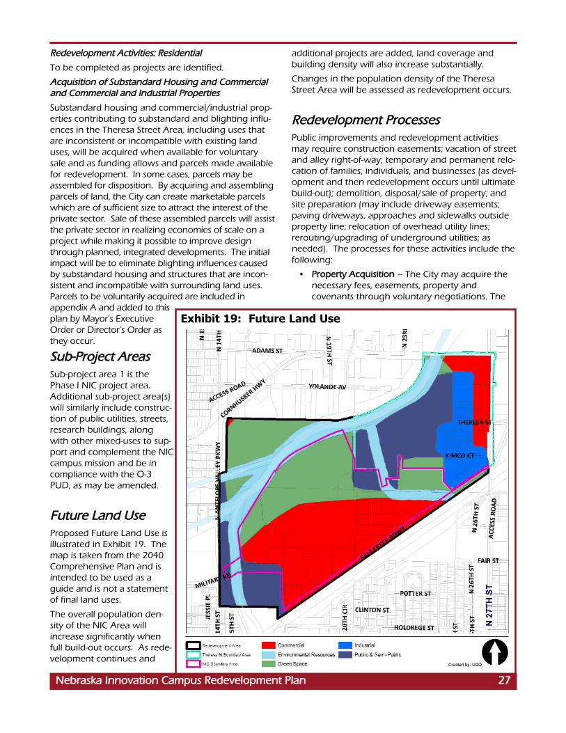
RReeddeevveellooppmmeenntt AAccttiivviittiieess:: RReessiiddeennttiiaall
To be completed as projects are identified.
AAccqquuiissiittiioonn ooff SSuubbssttaannddaarrdd HHoouussiinngg aanndd CCoommmmeerrcciiaallaanndd CCoommmmeerrcciiaall aanndd IInndduussttrriiaall PPrrooppeerrttiieess
Substandard housing and commercial/industrial prop-erties contributing to substandard and blighting influ-ences in the Theresa Street Area, including uses thatare inconsistent or incompatible with existing landuses, will be acquired when available for voluntarysale and as funding allows and parcels made availablefor redevelopment. In some cases, parcels may beassembled for disposition. By acquiring and assemblingparcels of land, the City can create marketable parcelswhich are of sufficient size to attract the interest of theprivate sector. Sale of these assembled parcels will assistthe private sector in realizing economies of scale on aproject while making it possible to improve designthrough planned, integrated developments. The initialimpact will be to eliminate blighting influences causedby substandard housing and structures that are incon-sistent and incompatible with surrounding land uses.Parcels to be voluntarily acquired are included inappendix A and added to thisplan by Mayor’s ExecutiveOrder or Director’s Order asthey occur.
SSuubb--PPrroojjeecctt AArreeaass Sub-project area 1 is thePhase I NIC project area.Additional sub-project area(s)will similarly include construc-tion of public utilities, streets,research buildings, alongwith other mixed-uses to sup-port and complement the NICcampus mission and be incompliance with the O-3PUD, as may be amended.
FFuuttuurree LLaanndd UUsseeProposed Future Land Use isillustrated in Exhibit 19. Themap is taken from the 2040Comprehensive Plan and isintended to be used as aguide and is not a statementof final land uses.
The overall population den-sity of the NIC Area willincrease significantly whenfull build-out occurs. As rede-velopment continues and
additional projects are added, land coverage andbuilding density will also increase substantially.
Changes in the population density of the TheresaStreet Area will be assessed as redevelopment occurs.
RReeddeevveellooppmmeenntt PPrroocceesssseessPublic improvements and redevelopment activitiesmay require construction easements; vacation of streetand alley right-of-way; temporary and permanent relo-cation of families, individuals, and businesses (as devel-opment and then redevelopment occurs until ultimatebuild-out); demolition, disposal/sale of property; andsite preparation (may include driveway easements;paving driveways, approaches and sidewalks outsideproperty line; relocation of overhead utility lines;rerouting/upgrading of underground utilities; asneeded). The processes for these activities include thefollowing:
• PPrrooppeerrttyy AAccqquuiissiittiioonn – The City may acquire thenecessary fees, easements, property andcovenants through voluntary negotiations. The
Exhibit 19: Future Land Use
NNeebbrraasskkaa IInnnnoovvaattiioonn CCaammppuuss RReeddeevveellooppmmeenntt PPllaann 2277

3300 NNeebbrraasskkaa IInnnnoovvaattiioonn CCaammppuuss RReeddeevveellooppmmeenntt PPllaann3300 NNeebbrraasskkaa IInnnnoovvaattiioonn CCaammppuuss RReeddeevveellooppmmeenntt PPllaann2288 NNeebbrraasskkaa IInnnnoovvaattiioonn CCaammppuuss RReeddeevveellooppmmeenntt PPllaann
City of Lincoln Land Acquisition Policy Statementis on file at the Urban Development Department,555 S. 10th St, Suite 205, Lincoln, NE 68508.However, if voluntary agreement is not possible,the City may institute eminent domain proceed-ings.
• RReellooccaattiioonn – Relocation may involve the tempo-rary or permanent relocation of families, individu-als, or businesses to complete redevelopmentactivities. Relocation will be completed accordingto local, state, and federal relocation regulations.The City of Lincoln Relocation Assistance manualis on the City website: www. lincoln.ne.gov, key-word: “relocation” and available from the UrbanDevelopment Department, 555 S. 10th Street,Suite 205, Lincoln, NE 68508.
• DDeemmoolliittiioonn – Demolition will include clearingsites on property proposed for public improve-ments; necessary capping, removal or replacingutilities; site preparation; securing insurance andbonds; and taking other necessary measures toprotect citizens and surrounding properties.Measures to mitigate environmental findings mayalso be necessary, if determined by site testing.
• DDiissppoossaall//DDiissppoossiittiioonn – Sub-area projects willinclude the sale of land to private developers forredevelopment purposes. Developers will beselected in an equitable, open, and competitiveproposal process.
• RReeqquueessttss ffoorr PPrrooppoossaallss – Architects and engineerswill follow the City’s standard selection processesto design the public facilities and improvements.Primary contractors will also be competitivelyselected.
EEssttiimmaatteedd EExxppeennddiittuurreess Preliminary estimates of project costs will be com-pleted as projects occur. Public improvements willneed to be prioritized and constructed as TaxIncrement Financing (TIF) dollars are generated.
Cost benefit analyses will be completed as projectsoccur. A preliminary cost benefit analysis for NICPhase 1 projects is included in Appendix B.
According to the Business Development Strategy com-pleted in conjunction with the NIC Master Plan:
“Development of the NIC will have a substan-tial positive economic impact on the localcommunity and State of Nebraska. In addi-tion to the over $800 million of new invest-ment in buildings and facilities, with the cor-responding construction employment suchinvestment will generate, it is estimated thatat full build-out the Campus will provide
direct employment of 2,835 Full TimeEquivalent (FTE) people. Assuming 75 per-cent of these are new jobs to the region, theNIC will generate 2,215 net new direct jobs.The bulk of these positions will be high-pay-ing research and technician jobs which areprojected to average $70,000 per year in2009 dollars. That equates to a projecteddirect annual payroll of $148,750,000 in2009 dollars.” (p. 25)
CCoonnffoorrmmaannccee wwiitthh CCoommpprreehheennssiivvee PPllaannThe Lincoln-Lancaster County Comprehensive Plan,adopted October, 2011, represents the local goals,objectives, and policies of the City of Lincoln. TheNebraska Innovation Campus (NIC) RedevelopmentPlan was developed to be consistent with theComprehensive Plan.
FFiinnaanncciinnggThe Nebraska Innovation Campus DevelopmentCorporation (NICDC) and the private sector will provideprimary financing for revitalization of theRedevelopment Area. The City must provide public serv-ices and public improvements and participate wherenecessary in the redevelopment process, but the needsof the area are beyond the City’s capacity to do alone.Financing of proposed improvements will require partici-pation by both the private and public sectors. Whereappropriate, the City may participate by providing finan-cial assistance for the rehabilitation of structures.
Sources of funding may include the following if avail-able and where appropriate:
1. Special Assessments – Business ImprovementDistricts
2. Private Contributions
3. Sale of Land (Proceeds from the sale of landacquired for redevelopment, as identified in theRedevelopment Plan, shall be reinvested in theRedevelopment Area).
4. Municipal Infrastructure Redevelopment Fund(MIRF)
5. Community Development Block Grant Funds(CDBG)
6. Home Investment Partnership Act (HOME)
7. HUD Section 108 Loan Program
8. Community Improvement (Tax Increment)Financing (Ad Valorem Tax)

NNeebbrraasskkaa IInnnnoovvaattiioonn CCaammppuuss RReeddeevveellooppmmeenntt PPllaann 33113311 NNeebbrraasskkaa IInnnnoovvaattiioonn CCaammppuuss RReeddeevveellooppmmeenntt PPllaann3311 NNeebbrraasskkaa IInnnnoovvaattiioonn CCaammppuuss RReeddeevveellooppmmeenntt PPllaannNNeebbrraasskkaa IInnnnoovvaattiioonn CCaammppuuss RReeddeevveellooppmmeenntt PPllaann 2299
9. Capital Improvements Program Budget
10. Federal and State Grants
11. Interest Income
12. Advance Land Acquisition Fund – propertyrights/easements, public facility site acquisition
13. Impact Fees.
Project activities will be undertaken subject to the limitand source of funding authorized and approved bythe Mayor and City Council.
According to the Community Development Law, anyad valorem tax levied upon real property in the rede-velopment project for the benefit of any public bodyshall be divided, for a period not exceed 15 years afterthe effective date of such provision, by the governingbody as follows:
That portion of the ad valorem tax which is producedby the levy at the rate fixed each year by or for eachsuch public body upon the redevelopment project val-uation shall be paid into the funds of each such publicbody in the same proportion as are all other taxes col-lected by or for the body; and
That portion of the ad valorem tax on real property inthe redevelopment project in excess of such amount,if any, shall be allocated to and, when collected, paid
into a special fund of the authority to be used solely topay the principal of, the interest on, and any premi-ums due in connection with the bonds of loan, notes,or advances of money to, or indebtedness incurred by,whether funded, refunded, assumed, or otherwise,such authority for financing or refinancing, in wholeor in part, the redevelopment project. When suchbonds, loans, notes, advances of money, or indebted-ness, including interest and premiums due, have beenpaid, the authority shall so notify the county assessorand county treasurer and all ad valorem taxes upontaxable real property in such a redevelopment projectshall be paid into the funds of the respective publicbodies.
The effective date for the Community ImprovementFinancing shall be that identified in the project rede-velopment contract or in the resolution of the author-ity authorizing the issuance of bonds pursuant to Neb.Rev. Stat. Section 18-2124.

3300 NNeebbrraasskkaa IInnnnoovvaattiioonn CCaammppuuss RReeddeevveellooppmmeenntt PPllaann
AAPPPPEENNDDIIXX AA:: PPRROOPPEERRTTIIEESS TTOO BBEE AACCQQUUIIRREEDD

PPuubblliicc IInnffrraassttrruuccttuurree aanndd CCoommmmuunniittyy PPuubblliicc SSeerrvviicceeNNeeeeddss IImmppaaccttss.. It is not anticipated that the Projectwill have an adverse impact on existing public infra-structure. In fact, the Project entails the capture of theincremental tax revenues for the purpose of construct-ing new public infrastructure. Existing infrastructurewas affiliated with the former State Fair Park. Its ageand condition requires replacement of the water, sani-tary, and storm sewer systems and reconstruction ofstreets, all of which is planned with the Project.
It is not anticipated that the Project will have anyadverse impact on City Public Services, but will gener-ate substantial revenue providing support for thoseservices.
EEmmppllooyymmeenntt WWiitthhiinn tthhee PPrroojjeecctt AArreeaa.. It is not antici-pated that the Project will have an adverse impact onemployers and employees of firms locating within theboundaries of the redevelopment project. At fullbuild-out, Nebraska Innovation Campus is anticipatedto create significant additional employment in thecommunity be creating approximately 7,000 new jobs.When secondary employment effects in other employ-ment sectors are added, the total employment effectsare expected to be significantly higher.
EEmmppllooyymmeenntt iinn tthhee CCiittyy OOuuttssiiddee tthhee PPrroojjeecctt AArreeaa..Approximately 139,003 persons living in the City ofLincoln were employed, according to the 2006-2010American Community Survey. The median householdincome for the City in 2010 was $47,526.
The impact of an additional estimated 7,000 jobs atfull build-out will have a slight impact on the overallemployment in the City.
OOtthheerr IImmppaaccttss.. NIC is a public/private partnership andresearch park dedicated to advancing research and itscommercialization in order to generate economicgrowth for Nebraska. By creating partnerships withprivate sector firms, economic opportunities will bemaximized and it will leverage the research capacity,faculty and student resources of UNL. Private sectorcompanies with existing or proposed relationshipswith the University will be attracted to locate adjacentto the University campus generating jobs and othereconomic activity for the State of Nebraska.Agricultural biotechnology and life science researchare anticipated to be strong components of the cam-pus. Other areas of University research strength thatprovide opportunities for viable partnerships includefood science and food safety, robotics, computer tech-nology, laser sciences, transportation, energy scienceand alternative energy.
NNeebbrraasskkaa IInnnnoovvaattiioonn CCaammppuuss RReeddeevveellooppmmeenntt PPllaann 3333NNeebbrraasskkaa IInnnnoovvaattiioonn CCaammppuuss RReeddeevveellooppmmeenntt PPllaann 3311
AAPPPPEENNDDIIXX BB:: NNIICC PPHHAASSEE II CCOOSSTT BBEENNEEFFIITT AANNAALLYYSSIISSThe Phase I Project Area is shown on Exhibit 8, page22. Projects include construction of public utilities,streets, up to four new buildings and the rehabilitationof two existing historic buildings. As required byNebraska Community Development Law(Neb.Rev.Stat. §18-2113) the City has analyzed thecosts and benefits of the proposed Project including:
TTaaxx RReevveennuueess The assessed value of the property within the projectarea will increase by an estimated $40.4 million as aresult of the projected $51,375,885 total privateinvestment. This incremental tax value will result in anestimated annual increase of $817,770 in property taxcollections that will be available for debt service on TIFindebtedness incurred for the construction of eligiblepublic improvements related to the project during the15 year TIF period. The public investment of a pro-jected $6.6 million in TIF funds will leverage$51,375,885 in private sector financing: a privateinvestment of $7.74 for every City dollar spent.
The State of Nebraska is also contributing to the proj-ect. The State legislature authorized $10,000,000 forassistance in renovating the 4-H building and$15,000,000 for the Life Science building. An addi-tional $25,000,000 is being raised through philan-thropy bringing total investment in Phase I NIC to$108,015,045. TIF represents 6.1% of total invest-ment.
TTaaxx IInnccrreemmeenntt FFiinnaanncciinngg AAnnaallyyssiiss
DDeessccrriippttiioonn
Total Private Investment (80% of total investment)
$41,100,708
Base Value (estimated current value)
$ 721,244
Increment Value $40,379,464
TIF Generated (Increment x .02025212 rate)
$ 817,770
1.2 Coverage $ 681,475
Bond/Note Issue (15 years @5.25%)
$ 6,639,130
NNeebbrraasskkaa IInnnnoovvaattiioonn CCaammppuuss RReeddeevveellooppmmeenntt PPllaann 3311

3322 NNeebbrraasskkaa IInnnnoovvaattiioonn CCaammppuuss RReeddeevveellooppmmeenntt PPllaann
NIC will create up to 7,000 new jobs at full build-outand will increase business and tax base withoutadverse effect on either public or private entities.There will be a material tax shift because of the use oftax increment financing, but there will also be signifi-cant personal property tax and other municipal rev-enue generated for the immediate benefit of the com-munity. The Project will also contribute to municipalrevenues through excise taxes, fees, licenses, salestaxes, and other taxes that occur and are paid in thecourse of the normal operation of businesses.
The Project should have a positive impact on privatesector businesses in and around the area outside the
boundaries of the redevelopment project. The Projectis not anticipated to impose a burden or have a nega-tive impact on other local area employers, but shouldincrease the need for services and products from exist-ing businesses. For example, ongoing maintenanceand service functions along with a general need forparts and supplies including the purchase of food,paper products and janitorial services. It is also antici-pated that business contacts and visitors to NIC will bespending dollars on a local basis for lodging, food andperipheral needs.