Embed Size (px)
Citation preview
§̈¦410
§̈¦35
§̈¦410
µData Source: City of San Antonio Enterprise GIS, Bexar Metro 911, Bexar Appra isal District
"This Geographic Information System Product received from the City of San Antonio is provided "as is" without warranty of any kind, and the City of San Antonio expressly disclaims all expressed and implied warranties, including but not l imited to the implied warranties of merchantabil ity and fitness for a particular purpose. The City of San Antonio does not warrant, guarantee, or make any representations regarding the use, or the resu lts of the use, of the information provided to you by the City o f San Antonio in terms of correctness, accuracy, rel iabi lity, timel iness or otherwise. The entire risk as to the resul ts and performance of any information obtained from the City of San Antonio is entire ly assumed by the recipient."
"Please contact the City of San Antonio Department for specific determinations."
Map Created by: Michael Taylor, AICPMap Creation Date: May 8, 2013Map File Location: K:\00001 - Communi ty Development Division\Corridor Reinvestment\Northeast Corridor\MapsPDF Filename: NEC_BoundaryMap
0 0.25 0.50.125Miles NORTHEAST CORRIDOR
Boundary Map
Perri
n Be
itel
Perri
n Be
itel
Nacogdoch
es
Nacogdoch
es
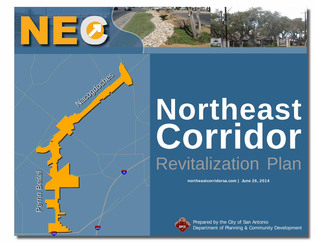
NortheastCorridorRevitalization Plan
Prepared by the City of San AntonioDepartment of Planning & Community Development
northeastcorridorsa.com | June 26, 2014

| 3
Table of ContentsOVERVIEW
Introduction & Purpose Statement ..............................................................4General Goals ............................................................................................5
COMMUNITY ENGAGEMENTPartners ....................................................................................................9Community Input .......................................................................................9
AREA ASSESSMENTCorridor Geography ..................................................................................10Trade Area Demographics .........................................................................11Infrastructure ..........................................................................................12Transit ....................................................................................................13Public Space ............................................................................................13Housing ..................................................................................................14Commercial .............................................................................................15
STRATEGIC ACTION PLANIntroduction & Summary Table..................................................................19Strategic Actions ......................................................................................20
Organization .......................................................................................20Design ................................................................................................20Marketing ...........................................................................................24Business Development .........................................................................25
PROJECT FUNDINGProject Matrix ..........................................................................................26
Northeast Corridor Steering CommitteeThe NEC Steering Committee is responsible for the planning and implementation of the Northeast Corridor Revitalization Initiative. The dedicated members of the Steering Committee represent various stakeholder groups in the community with an interest in bringing new vitality to the Perrin Beitel and Nacogdoches corridors.
Mike Gallagher District 10 City Council Member
John Clamp President, Northeast Neighborhood Alliance & Former District 10 City Council Member
Billy Hill Founder & Owner, Hill Electric
Mario Hune Chief of Staff, District 10 City Council
Jack Judson Austin Highway Revitalization Initiative
Bud Little President, Hills of Park North Neighborhood Association
Carlos Pena Senior Vice President, Jefferson Bank
Carlton Soules Former District 10 City Council Member
StaffStaff support provided by the City of San Antonio Department of Planning & Community Development.
Michael Taylor NEC Revitalization ManagerVisit northeastcorridorsa.com for NEC updates
4 | OVERVIEW
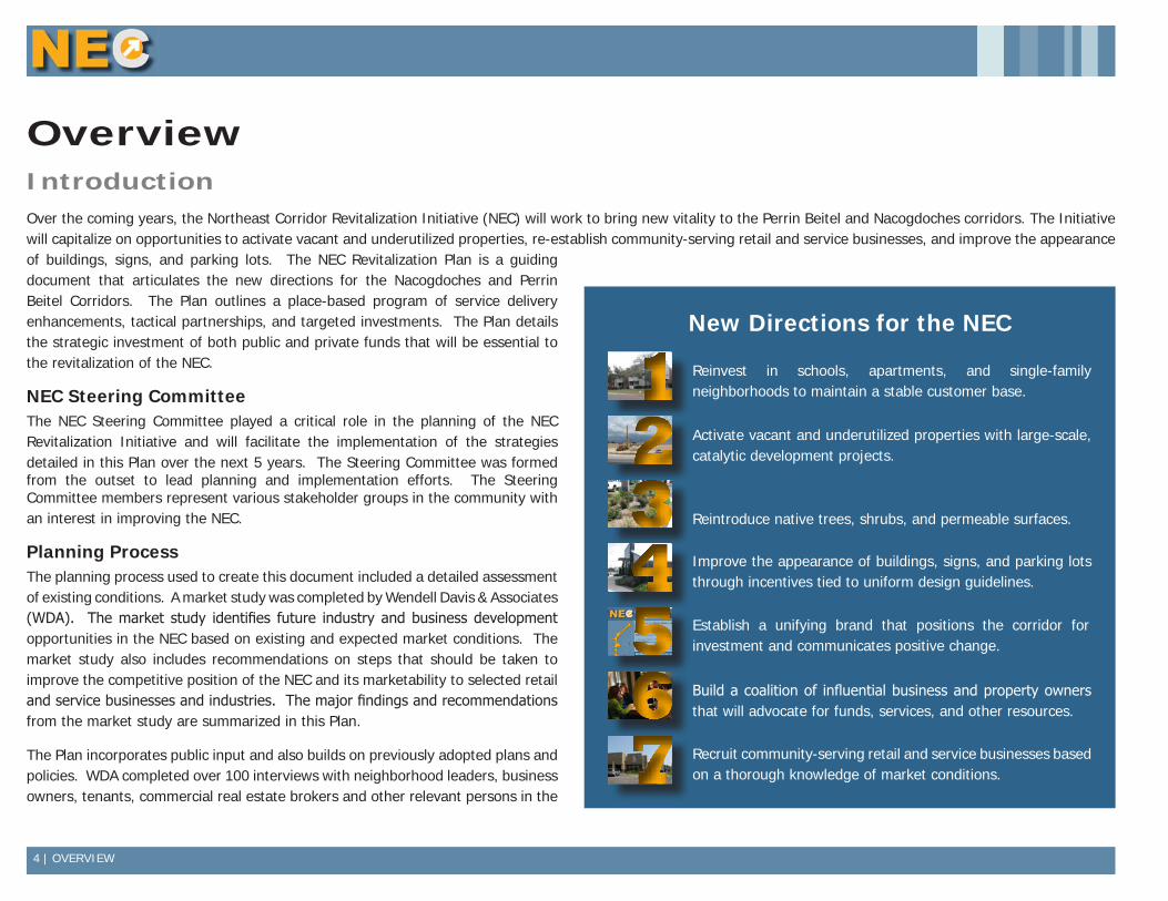
IntroductionOver the coming years, the Northeast Corridor Revitalization Initiative (NEC) will work to bring new vitality to the Perrin Beitel and Nacogdoches corridors. The Initiative will capitalize on opportunities to activate vacant and underutilized properties, re-establish community-serving retail and service businesses, and improve the appearance of buildings, signs, and parking lots. The NEC Revitalization Plan is a guiding document that articulates the new directions for the Nacogdoches and Perrin Beitel Corridors. The Plan outlines a place-based program of service delivery enhancements, tactical partnerships, and targeted investments. The Plan details the strategic investment of both public and private funds that will be essential to the revitalization of the NEC.
NEC Steering CommitteeThe NEC Steering Committee played a critical role in the planning of the NEC Revitalization Initiative and will facilitate the implementation of the strategies detailed in this Plan over the next 5 years. The Steering Committee was formed from the outset to lead planning and implementation efforts. The Steering Committee members represent various stakeholder groups in the community with an interest in improving the NEC.
Planning ProcessThe planning process used to create this document included a detailed assessment of existing conditions. A market study was completed by Wendell Davis & Associates (WDA). The market study identifies future industry and business development opportunities in the NEC based on existing and expected market conditions. The market study also includes recommendations on steps that should be taken to improve the competitive position of the NEC and its marketability to selected retail and service businesses and industries. The major findings and recommendations from the market study are summarized in this Plan.
The Plan incorporates public input and also builds on previously adopted plans and policies. WDA completed over 100 interviews with neighborhood leaders, business owners, tenants, commercial real estate brokers and other relevant persons in the
New Directions for the NEC
1 Reinvest in schools, apartments, and single-family neighborhoods to maintain a stable customer base.
2 Activate vacant and underutilized properties with large-scale, catalytic development projects.
34
§̈¦410
§̈¦35
§̈¦410
µData Source: City of San Antonio Enterprise GIS, Bexar Metro 911, Bexar Appra isal District
"This Geographic Information System Product received from the City of San Antonio is provided "as is" without warranty of any kind, and the City of San Antonio expressly disclaims all expressed and implied warranties, including but not l imited to the implied warranties of merchantabil ity and fitness for a particular purpose. The City of San Antonio does not warrant, guarantee, or make any representations regarding the use, or the results of the use, of the information provided to you by the City o f San Antonio in terms of correctness, accuracy, rel iabi lity, timel iness or otherwise. The entire risk as to the resul ts and performance of any information obtained from the City of San Antonio is entire ly assumed by the recipient."
"Please contact the City of San Antonio Department for specific determinations."
Map Created by: Michael Taylor, AICPMap Creation Date: May 8, 2013Map File Location: K:\00001 - Communi ty Development Division\Corridor Reinvestment\Northeast Corridor\MapsPDF Filename: NEC_BoundaryMap
0 0.25 0.50.125Miles NORTHEAST CORRIDOR
Boundary Map
Perr
in B
eite
lPe
rrin
Bei
tel
Nacog
doch
es
Nacog
doch
esRestore vitality to the Perrin Beitel and Nacogdoches corridors.
Capitalize on opportunities to activate vacant and underutilized properties,
re-establish community-serving retail and service businesses, and
improve the appearance of buildings, signs, and parking lots.
A place-based program of service delivery enhancements, tactical
partnerships, and targeted investments.
Incentives are available to help you improve your commercial property. Visit
northeastcorridorsa.com for more information.
Northeast Corridor Revitalization Initiative
§̈¦410
§̈¦35
§̈¦410
µData Source: City of San Antonio Enterprise GIS, Bexar Metro 911, Bexar Appra isal District
"This Geographic Information System Product received from the City of San Antonio is provided "as is" without warranty of any kind, and the City of San Antonio expressly disclaims all expressed and implied warranties, including but not l imited to the implied warranties of merchantabil ity and fitness for a particular purpose. The City of San Antonio does not warrant, guarantee, or make any representations regarding the use, or the results of the use, of the information provided to you by the City o f San Antonio in terms of correctness, accuracy, rel iabi lity, timel iness or otherwise. The entire risk as to the resul ts and performance of any information obtained from the City of San Antonio is entire ly assumed by the recipient."
"Please contact the City of San Antonio Department for specific determinations."
Map Created by: Michael Taylor, AICPMap Creation Date: May 8, 2013Map File Location: K:\00001 - Communi ty Development Division\Corridor Reinvestment\Northeast Corridor\MapsPDF Filename: NEC_BoundaryMap
0 0.25 0.50.125Miles NORTHEAST CORRIDOR
Boundary Map
Perr
in B
eite
lPe
rrin
Bei
tel
Nacog
doch
es
Nacog
doch
esRestore vitality to the Perrin Beitel and Nacogdoches corridors.
Capitalize on opportunities to activate vacant and underutilized properties,
re-establish community-serving retail and service businesses, and
improve the appearance of buildings, signs, and parking lots.
A place-based program of service delivery enhancements, tactical
partnerships, and targeted investments.
Incentives are available to help you improve your commercial property. Visit
northeastcorridorsa.com for more information.
Northeast Corridor Revitalization Initiative
567
Reintroduce native trees, shrubs, and permeable surfaces.
Improve the appearance of buildings, signs, and parking lots through incentives tied to uniform design guidelines.
Establish a unifying brand that positions the corridor for investment and communicates positive change.
Build a coalition of influential business and property owners that will advocate for funds, services, and other resources.
Recruit community-serving retail and service businesses based on a thorough knowledge of market conditions.
Overview

OVERVIEW | 5
trade area as well as those familiar with the area and the real estate market. The purpose of these interviews was to gain information about the area and the real estate market including opinions of knowledgeable people on what will and won’t work in the area.
The market study, overall assessment, and public input were used as the basis for developing strategies to improve conditions in the NEC. Each strategy includes a time frame for completion and planned sources and uses of funds. The Plan meets the criteria of a Community Revitalization Plan under the Texas Department of Housing and Community Affairs (TDHCA) 2013 Qualified Allocation Plan.
GoalsThe NEC Revitalization Plan includes 7 major goals that are organized into 4 basic categories: Organization, Design, Marketing, and Business Development. Collectively these goals articulate a New Direction for the NEC that remakes the corridor into a more sustainable place.
ORGANIZATION ▪ Build a coalition of influential business and property owners that will advocate for funds, services, and other resources.
DESIGN ▪ Activate vacant and underutilized properties with large-scale, catalytic development projects. ▪ Reintroduce native trees, shrubs, and permeable surfaces. ▪ Improve the appearance of buildings, signs, and parking lots through incentives tied to uniform design guidelines.
MARKETING
▪ Establish a unifying brand that positions the corridor for investment and communicates positive change.
BUSINESS DEVELOPMENT ▪ Reinvest in schools, apartments, and single-family neighborhoods to maintain a stable customer base. ▪ Recruit community-serving retail and service businesses based on a thorough knowledge of market conditions.
OrganizationStrong organization is critical to creating a revitalization effort that is sustainable over the course of many years. The organizational structure must be action focused, scalable, and adaptable to change. At the core of the organizational structure of the NEC Revitalization Initiative is the NEC Steering Committee. The Steering Committee includes represents the various stakeholder groups and includes business owners, residents, current and former council members, and a representative from the financial sector. The Steering Committee was integral in the development of the Revitalization Plan and will be an even
Hill Electric repurposed a former restaurant into a state of the art headquarters (top). First Choice Emergency Room repurposed a former video store into a new emergency clinic (middle). Revitalization efforts focus on the commercial corridor and the residential trade area (bottom).
6 | OVERVIEW
more important part of facilitating the implementation of the Plan.
The NEC Steering Committee is closely aligned with the Northeast Neighborhood Alliance (NNA). The NNA includes 85 northeast side neighborhood and homeowners associations as members. The NNA provides these neighborhood and homeowners associations with a forum for the exchange of information and a united voice that influences important program and policy decisions. The NEC Steering Committee and NNA must continue to work together to achieve outcomes that benefit the entire community.
It is anticipated that the Steering Committee will form subcommittees to deal with specific issues and needs and that these subcommittees could be spun-off into new groups and organizations. These groups could include one or more merchants associations to represent the collective interests of business owners within the corridor and a Tax Increment Reinvestment Zone (TIRZ) Board that would make decisions on how tax increment collected will be utilized to catalyze investment in the NEC. The Steering Committee will remain at the core to the Revitalization effort and provide overall direction to these supporting groups.
The following organization strategies should be employed:
1. GROW NEC NETWORK. Encourage strong pro-active leadership from within the Corridor business community to develop and expand a
network of property owners, brokers, and agents with an interest in redeveloping the NEC.
2. MEASURE PERFORMANCE. Monitor, define and measure success in an annual report.
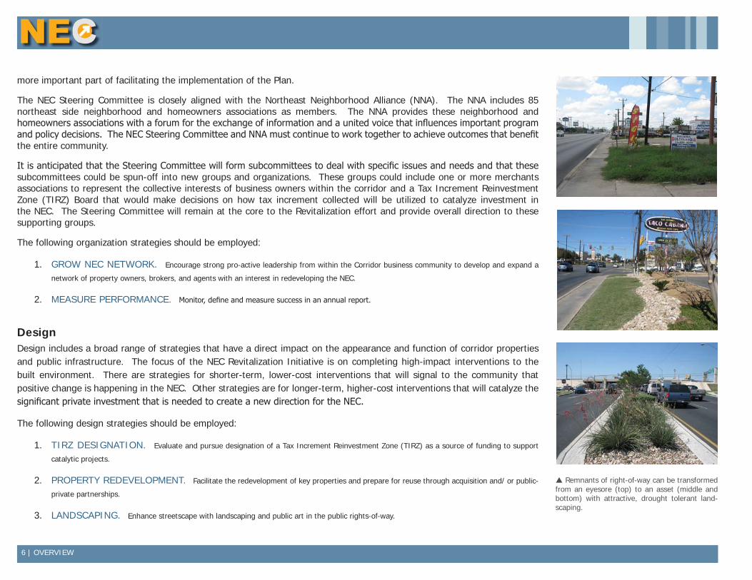
DesignDesign includes a broad range of strategies that have a direct impact on the appearance and function of corridor properties and public infrastructure. The focus of the NEC Revitalization Initiative is on completing high-impact interventions to the built environment. There are strategies for shorter-term, lower-cost interventions that will signal to the community that positive change is happening in the NEC. Other strategies are for longer-term, higher-cost interventions that will catalyze the significant private investment that is needed to create a new direction for the NEC.
The following design strategies should be employed:
1. TIRZ DESIGNATION. Evaluate and pursue designation of a Tax Increment Reinvestment Zone (TIRZ) as a source of funding to support
catalytic projects.
2. PROPERTY REDEVELOPMENT. Facilitate the redevelopment of key properties and prepare for reuse through acquisition and/ or public-
private partnerships.
3. LANDSCAPING. Enhance streetscape with landscaping and public art in the public rights-of-way.
Remnants of right-of-way can be transformed from an eyesore (top) to an asset (middle and bottom) with attractive, drought tolerant land-scaping.
OVERVIEW | 7
4. SUPPORTIVE ZONING. Support zoning changes that are consistent with NEC revitalization goals.
5. DESIGN GUIDELINES. Adopt uniform site and building design guidelines for the RETAIL and MIXED USE Segments of the Corridor.
6. DESIGN ASSISTANCE. Provide proactive and on-demand design assistance to property owners in the Corridor.
7. ADOPT-A-SPOT LITTER CONTROL PROGRAM. Encourage local individuals, organizations, and businesses to adopt remaining portions of the NEC through the Keep San Antonio Beautiful Adopt-A-Spot Litter Control Program and provide support to sustain ongoing clean-up
events.
8. TOP 10 IMPROVEMENT OPPORTUNITIES. Create and maintain rolling list of top 10 'improvement opportunities.
9. BEAUTIFICATION AWARD. Recognize those that model pride of place with a beautification award.
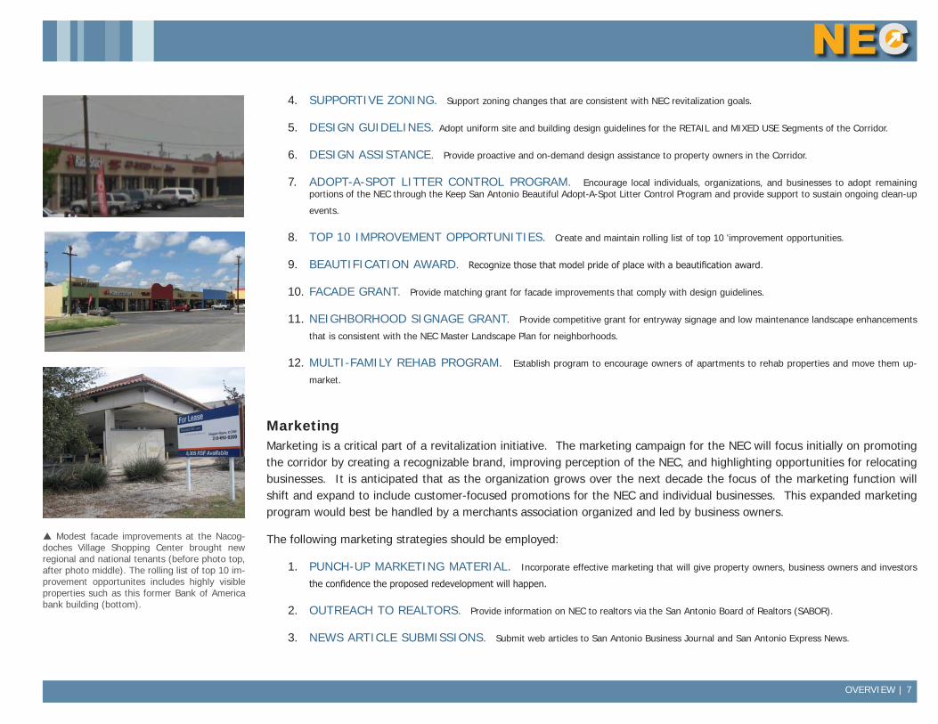
10. FACADE GRANT. Provide matching grant for facade improvements that comply with design guidelines.
11. NEIGHBORHOOD SIGNAGE GRANT. Provide competitive grant for entryway signage and low maintenance landscape enhancements
that is consistent with the NEC Master Landscape Plan for neighborhoods.
12. MULTI-FAMILY REHAB PROGRAM. Establish program to encourage owners of apartments to rehab properties and move them up-
market.
MarketingMarketing is a critical part of a revitalization initiative. The marketing campaign for the NEC will focus initially on promoting the corridor by creating a recognizable brand, improving perception of the NEC, and highlighting opportunities for relocating businesses. It is anticipated that as the organization grows over the next decade the focus of the marketing function will shift and expand to include customer-focused promotions for the NEC and individual businesses. This expanded marketing program would best be handled by a merchants association organized and led by business owners.
The following marketing strategies should be employed:
1. PUNCH-UP MARKETING MATERIAL. Incorporate effective marketing that will give property owners, business owners and investors
the confidence the proposed redevelopment will happen.
2. OUTREACH TO REALTORS. Provide information on NEC to realtors via the San Antonio Board of Realtors (SABOR).
3. NEWS ARTICLE SUBMISSIONS. Submit web articles to San Antonio Business Journal and San Antonio Express News.
Modest facade improvements at the Nacog-doches Village Shopping Center brought new regional and national tenants (before photo top, after photo middle). The rolling list of top 10 im-provement opportunites includes highly visible properties such as this former Bank of America bank building (bottom).
8 | OVERVIEW
4. COMMUNITY MEETINGS/ PRESS CONFERENCES. Host regular public meetings/ press conferences to provide status update to
stakeholders.
5. CHAMBER OUTREACH. Establish relationships with the area Chambers of Commerce including the Greater, North, and Hispanic to market
NEC properties.
Business DevelopmentCommercial revitalization initiatives usually include business development as a key component of the work program. The NEC Revitalization Initiative adds trade area development to the typical business development activities. This is in recognition of the fact that the businesses in a commercial corridor are dependent on the viability of the abutting residential areas where customers live (i.e. the trade area) just like the viability of the residential areas is dependent on the condition of abutting commercial areas and the availability of goods and services. A partnership with the NNA will allow for coordination and cooperation between initiatives for the commercial and residential areas.
Due to the size of the NEC and the prevalence of vacant space, the initial focus of business development efforts will be on attracting new businesses to the corridor. Business attraction efforts will focus specifically on business and industry types that have a competitive advantage in the NEC based on market conditions. It is anticipated that as the organization grows over the next decade business development efforts will expand to provide existing businesses with the technical assistance and access to capital needed to help them succeed and expand. This expanded business development program would best be handled by partnering with one of the existing chambers of commerce or the Small Business Development Center housed at the University of Texas at San Antonio.
It is important for business attraction efforts that the spending power and demand for goods and services in the abutting residential neighborhoods remain strong. However getting heavily involved with Trade Area development would generally require more resources than the NEC Revitalization Initiative could bring to bear. Fortunately, the Northeast Neighborhood Alliance (NNA) is an existing organization that is already focusing on trade area development through its work with the area neighborhood and homeowners associations. The NEC Steering Committee will support and partner with the NNA and generally work closely with this organization to ensure business development and trade area development work is aligned.
The following marketing strategies should be employed:
1. SUPPORT NORTHEAST NEIGHBORHOOD ALLIANCE. Support NENA to address neighborhood issues within the trade area.
2. PROVIDE REAL ESTATE LISTINGS. Maintain an inventory of active listings of for sale or lease properties.
3. BUSINESS ATTRACTION. Recruit retail, non-retail, and specialty business types from the Industry Groups recommended by market study.
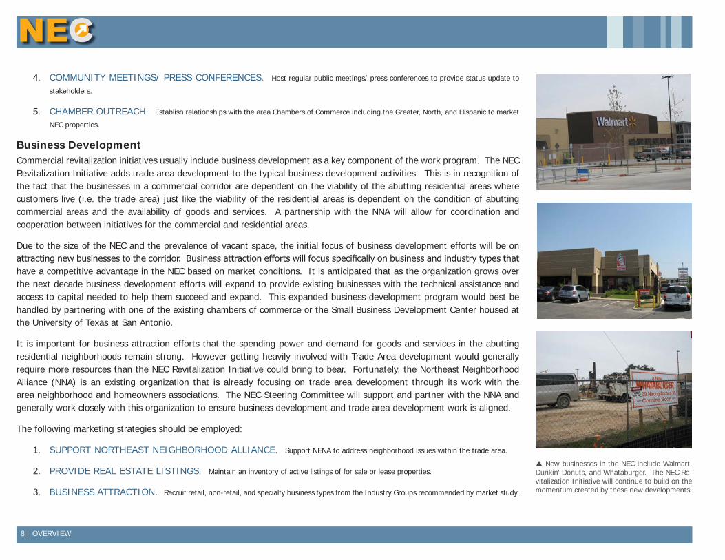
New businesses in the NEC include Walmart, Dunkin' Donuts, and Whataburger. The NEC Re-vitalization Initiative will continue to build on the momentum created by these new developments.
COMMUNITY ENGAGEMENT | 9
Community EngagementPartnersThe NEC Revitalization Initiative was launched by former District 10 Councilman Carlton Soules with staff support provided by the City of San Antonio Department of Planning and Community Development. The Steering Committee was formed soon after the initiative was launched to establish a partnership between the City of San Antonio and representatives from local businesses, financial institutions, and residents. This partnership was expanded through the community input efforts detailed in the Community Input section below. The planning process resulted in a strong partnership between the NEC Steering Committee and the Northeast Neighborhood Alliance. Many of the strategies in this document are aimed at continuing to grow the partnership network to include additional business owners and commercial property owners/ managers.
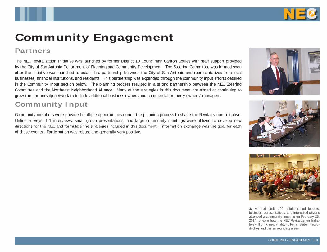
Community InputCommunity members were provided multiple opportunities during the planning process to shape the Revitalization Initiative. Online surveys, 1:1 interviews, small group presentations, and large community meetings were utilized to develop new directions for the NEC and formulate the strategies included in this document. Information exchange was the goal for each of these events. Participation was robust and generally very positive.
Approximately 100 neighborhood leaders, business representatives, and interested citizens attended a community meeting on February 25, 2014 to learn how the NEC Revitalization Initia-tive will bring new vitality to Perrin Beitel, Nacog-doches and the surrounding areas.
10 | AREA ASSESSMENT
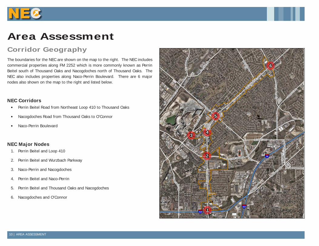
Area AssessmentCorridor GeographyThe boundaries for the NEC are shown on the map to the right. The NEC includes commercial properties along FM 2252 which is more commonly known as Perrin Beitel south of Thousand Oaks and Nacogdoches north of Thousand Oaks. The NEC also includes properties along Naco-Perrin Boulevard. There are 6 major nodes also shown on the map to the right and listed below.
NEC Corridors• Perrin Beitel Road from Northeast Loop 410 to Thousand Oaks
• Nacogdoches Road from Thousand Oaks to O'Connor
• Naco-Perrin Boulevard
NEC Major Nodes1. Perrin Beitel and Loop 410
2. Perrin Beitel and Wurzbach Parkway
3. Naco-Perrin and Nacogdoches
4. Perrin Beitel and Naco-Perrin
5. Perrin Beitel and Thousand Oaks and Nacogdoches
6. Nacogdoches and O'Connor
THOUSAND OAKS
RANDOLPH BV
PE
RR
IN B
EIT
EL
WE
IDN
ER
RD N
BULV
ERD
E R
D
WEI
DN
ER R
D N
O'C
ON
NO
R R
D
WE
IDN
ER
RD
N
T HO
USAN
D O
AKS
NACOGDOCHES RD
STAH
L RD
STA
RCREST
DR
LOOKOUT RD
HIGG
INS RD
WEIDNER RD S
SCHERTZ RD
WURZBACH PRKW
OLD
PE
RR
IN B
EIT
EL
WET
MOR
E RD
BULV
ERDE
RD
RANDOLPH
BV
§̈¦35
§̈¦410
§̈¦410
2
5
34
6
1µ
Data Source: City of San Antonio Enterprise GIS, Bexar Metro 911, Bexar Appra isal District
"This Geographic Information System Product received from the City of San Antonio is provided "as is" without warranty of any kind, and the City of San Antonio expressly disclaims all expressed and implied warranties, including but not l imited to the implied warranties of merchantabil ity and fitness for a particular purpose. The City of San Antonio does not warrant, guarantee, or make any representations regarding the use, or the resu lts of the use, of the information provided to you by the City o f San Antonio in terms of correctness, accuracy, rel iabi lity, timel iness or otherwise. The entire risk as to the resul ts and performance of any information obtained from the City of San Antonio is entire ly assumed by the recipient."
"Please contact the City of San Antonio Department for specific determinations."
City of San Antonio Planning Department GIS Manager: Dale Woodruff, [email protected]. Maps may be ordered at (210) 207-7873.
Map Created by: Michael Taylor, AICPMap Creation Date: Map File Location:PDF Filename:
0 0.25 0.50.125Miles NORTHEAST CORRIDOR
Major Nodes
AREA ASSESSMENT | 11
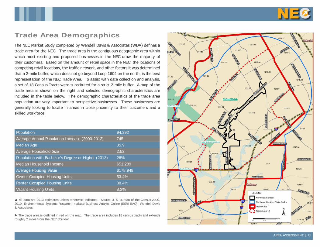
Trade Area DemographicsThe NEC Market Study completed by Wendell Davis & Associates (WDA) defines a trade area for the NEC. The trade area is the contiguous geographic area within which most existing and proposed businesses in the NEC draw the majority of their customers. Based on the amount of retail space in the NEC, the locations of competing retail locations, the traffic network, and other factors it was determined that a 2-mile buffer, which does not go beyond Loop 1604 on the north, is the best representation of the NEC Trade Area. To assist with data collection and analysis, a set of 18 Census Tracts were substituted for a strict 2-mile buffer. A map of the trade area is shown on the right and selected demographic characteristics are included in the table below. The demographic characteristics of the trade area population are very important to perspective businesses. These businesses are generally looking to locate in areas in close proximity to their customers and a skilled workforce.
Population 94,392
Average Annual Population Increase (2000-2013) 745
Median Age 35.9
Average Household Size 2.52
Population with Bachelor's Degree or Higher (2013) 26%
Median Household Income $51,289
Average Housing Value $178,948
Owner Occupied Housing Units 53.4%
Renter Occupied Housing Units 38.4%
Vacant Housing Units 8.2%
All data are 2013 estimates unless otherwise indicated. Source U. S. Bureau of the Census 2000, 2010; Environmental Systems Research Institute Business Analyst Online (ESRI BAO); Wendell Davis & Associates.
The trade area is outlined in red on the map. The trade area includes 18 census tracts and extends roughly 2 miles from the NEC Corridor.
12 | AREA ASSESSMENT
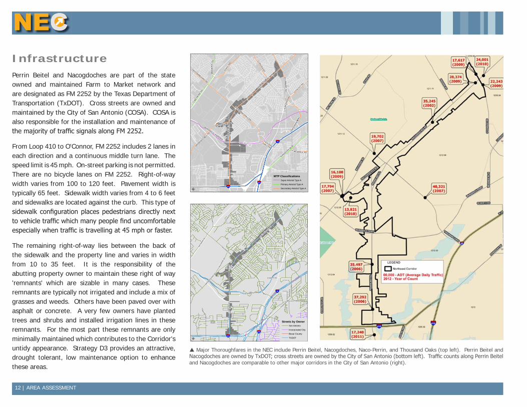
InfrastructurePerrin Beitel and Nacogdoches are part of the state owned and maintained Farm to Market network and are designated as FM 2252 by the Texas Department of Transportation (TxDOT). Cross streets are owned and maintained by the City of San Antonio (COSA). COSA is also responsible for the installation and maintenance of the majority of traffic signals along FM 2252.
From Loop 410 to O'Connor, FM 2252 includes 2 lanes in each direction and a continuous middle turn lane. The speed limit is 45 mph. On-street parking is not permitted. There are no bicycle lanes on FM 2252. Right-of-way width varies from 100 to 120 feet. Pavement width is typically 65 feet. Sidewalk width varies from 4 to 6 feet and sidewalks are located against the curb. This type of sidewalk configuration places pedestrians directly next to vehicle traffic which many people find uncomfortable especially when traffic is travelling at 45 mph or faster.
The remaining right-of-way lies between the back of the sidewalk and the property line and varies in width from 10 to 35 feet. It is the responsibility of the abutting property owner to maintain these right of way 'remnants' which are sizable in many cases. These remnants are typically not irrigated and include a mix of grasses and weeds. Others have been paved over with asphalt or concrete. A very few owners have planted trees and shrubs and installed irrigation lines in these remnants. For the most part these remnants are only minimally maintained which contributes to the Corridor's untidy appearance. Strategy D3 provides an attractive, drought tolerant, low maintenance option to enhance these areas.
§̈¦410
§̈¦35
§̈¦410
WET
MO
RE RD
WURZBACH PARKWAY
THOUSAND OAKS DR
O'C
ON
NO
R R
D
NACO-PERRIN
NACOGDOCHES RD
S
WEIDNER RD
RANDOLPH BLV
D
THOUSAND OAKS DR
LOOKOUT
RD
CLASSEN RD
NACOGDOCHES
RD
THOUSAND OAKS
DR
STAH
L RD
N W
EID
NE
R RD
PE
RR
IN B
EIT
EL
PE
RR
IN B
EIT
EL
BU
LVE
RD
E R
D
CRO
SSW
IND
S WAY
Data Source: City of San Antonio Enterprise GIS, Bexar Metro 911, Bexar Appra isal District
"This Geographic Information System Product received from the City of San Antonio is provided "as is" without warranty of any kind, and the City of San Antonio expressly disclaims all expressed and implied warranties, including but not l imited to the implied warranties of merchantabil ity and fitness for a particular purpose. The City of San Antonio does not warrant, guarantee, or make any representations regarding the use, or the resu lts of the use, of the information provided to you by the City o f San Antonio in terms of correctness, accuracy, rel iabi lity, timel iness or otherwise. The entire risk as to the resul ts and performance of any information obtained from the City of San Antonio is entire ly assumed by the recipient."
"Please contact the City of San Antonio Department for specific determinations."
City of San Antonio Planning Department GIS Manager: Dale Woodruff, [email protected]. Maps may be ordered at (210) 207-7873.
Map Created by: Michael Taylor, AICPMap Creation Date: Map File Location:PDF Filename:
0 0.25 0.50.125Miles NORTHEAST CORRIDOR
Major Thoroughfares
µ
MTP ClassificationsSuper Arterial Type A
Primary Arterial Type A
Secondary Arterial Type A
O'C
ON
NO
R R
D
BULV
ERD
E R
D
WE
IDN
ER
RD
N
STAH
L RD
THOUSAND OAKS
THO
USAN
D O
AKS
NACOGDOCHES RD
WE
I DN
ER
RD
N
LOOKOUT RD
WE
IDN
ER
RD N
HIGG
INS RD
WEIDNER RD S
NACOGDOCHES RD
SCHERTZ RD
WURZBACH PRKW
OLD
PER
RIN
BE
ITE
L
WET
MO
RE RD
BULV
ERDE
RD
RANDOLPH
BV
RANDOLPH BV
STA
RCREST
DR
PE
RR
IN B
EIT
EL
§̈¦35
§̈¦410
§̈¦410
Data Source: City of San Antonio Enterprise GIS, Bexar Metro 911, Bexar Appra isal District
"This Geographic Information System Product received from the City of San Antonio is provided "as is" without warranty of any kind, and the City of San Antonio expressly disclaims all expressed and implied warranties, including but not l imited to the implied warranties of merchantabil ity and fitness for a particular purpose. The City of San Antonio does not warrant, guarantee, or make any representations regarding the use, or the resu lts of the use, of the information provided to you by the City o f San Antonio in terms of correctness, accuracy, rel iabi lity, timel iness or otherwise. The entire risk as to the resul ts and performance of any information obtained from the City of San Antonio is entire ly assumed by the recipient."
"Please contact the City of San Antonio Department for specific determinations."
City of San Antonio Planning Department GIS Manager: Dale Woodruff, [email protected]. Maps may be ordered at (210) 207-7873.
Map Created by: Michael Taylor, AICPMap Creation Date: Map File Location:PDF Filename:
0 0.3 0.60.15Miles NORTHEAST CORRIDOR
Streets by Owner
µ
Streets by OwnerSan Antonio
Incorporated City
Bexar County
TXDOT
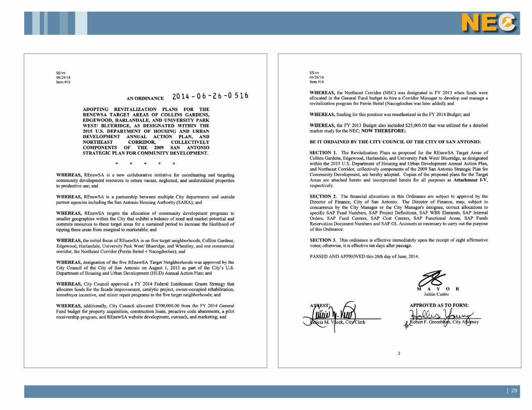
Northeast Corridor Revitalization Study Page 25
Map 13. TRAFFIC COUNTS IN THE CORRIDOR
While traffic counts have declined between10% and 20% over the past several years, the Northeast Corridor can hold its own against other corridors in the City with counts ranging from 35,000 to 37,000 on the lower part of Perrin Beitel to over 28,000 ADT along Nacogdoches between Thousand Oaks and O’Connor.
Northeast Corridor traffic counts are exceeded only by Grissom/Culebra with up to 40,000 ADT and SW Military Dr with 45,000 ADT.
Major Thoroughfares in the NEC include Perrin Beitel, Nacogdoches, Naco-Perrin, and Thousand Oaks (top left). Perrin Beitel and Nacogdoches are owned by TxDOT; cross streets are owned by the City of San Antonio (bottom left). Traffic counts along Perrin Beitel and Nacogdoches are comparable to other major corridors in the City of San Antonio (right).
AREA ASSESSMENT | 13
TransitThere are two main VIA bus routes that service the NEC. Route 14 provides frequent level service from the NEC to Downtown with stops in Alamo Heights and at Incarnate Word University. Route 642 provides metro level service from the NEC to Rolling Oaks Mall. These routes come together at the Naco Pass transfer area which today is a collection of stops and shelters located along the perimeter of a cul-de-sac surrounded by industrial uses. VIA is investigating the feasibility of replacing this informal transfer area with a permanent transit center that includes an enclosed waiting area with rest rooms, vending machines , staff to assist riders, and limited parking1.
VIA's Long Range Comprehensive Transportation Plan calls for adding Bus Rapid Transit (BRT) service on Perrin Beitel. The Northeast/ Southeast BRT route would start at a new Naco Pass Transit Center, travel down Perrin Beitel and Austin Highway, through Downtown, down Roosevelt Avenue and terminate on Military Drive. BRT provides fixed rail type service by using larger, articulated buses, stations with level boarding heights, dedicated travel lanes and traffic signal prioritization2. BRT can act as a catalyst for denser, transit-oriented, mixed-use development along the route and especially near transit centers. Transit oriented development would provide a way to add the additional residential units needed to support commercial establishments in the NEC while minimizing the impact on adjacent single-family neighborhoods.
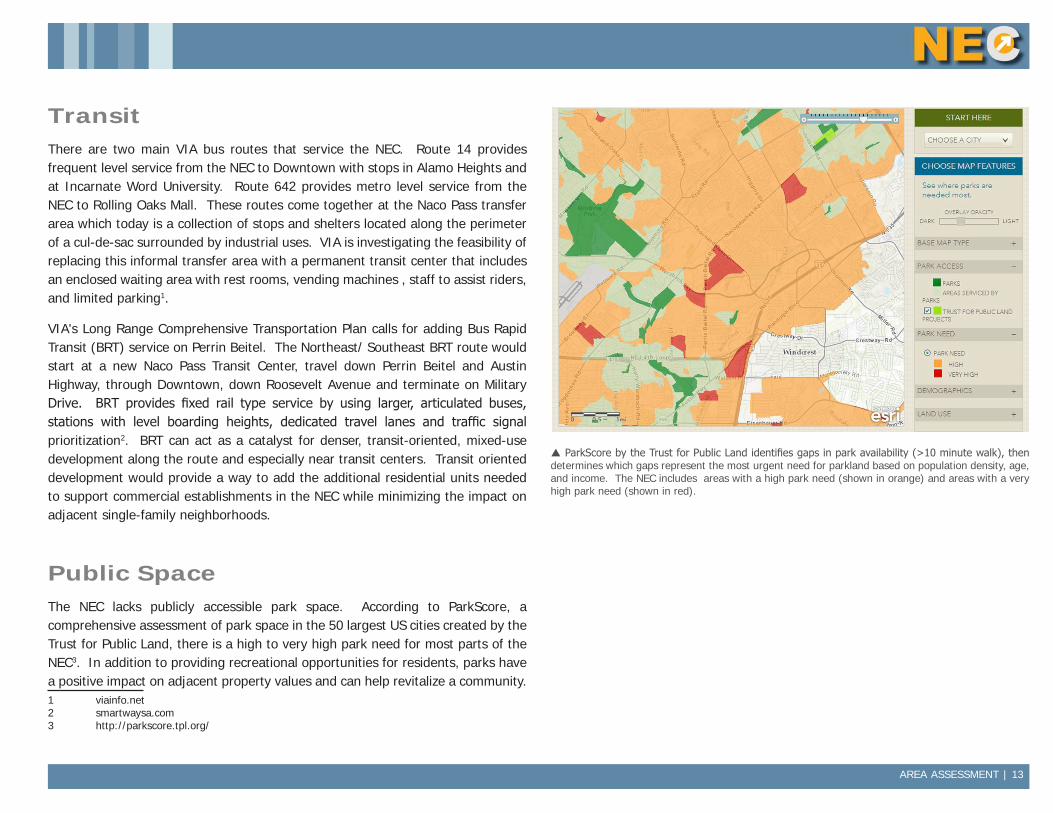
Public SpaceThe NEC lacks publicly accessible park space. According to ParkScore, a comprehensive assessment of park space in the 50 largest US cities created by the Trust for Public Land, there is a high to very high park need for most parts of the NEC3. In addition to providing recreational opportunities for residents, parks have a positive impact on adjacent property values and can help revitalize a community. 1 viainfo.net2 smartwaysa.com3 http://parkscore.tpl.org/
ParkScore by the Trust for Public Land identifies gaps in park availability (>10 minute walk), then determines which gaps represent the most urgent need for parkland based on population density, age, and income. The NEC includes areas with a high park need (shown in orange) and areas with a very high park need (shown in red).
14 | AREA ASSESSMENT
A park or green in a commercial corridor can serve as a focal point and gathering spot for festivals and other events that will draw customers from other parts of the City. Strategy D2 identifies a potential site within the NEC for a new park. Other sites would also be considered.
HousingThe trade area includes mostly owner-occupied, single-family housing units that are in average condition or above with values that are affordable for middle class families. The housing section includes a description of housing value, ownership status, and housing condition.
Housing ValueAverage housing value in the trade area is $178,948. The average housing value for the trade area is slightly below that of the City ($183,506) and the County ($199,793). The majority of the housing units in the trade area are valued between $150,000 and $299,999.
Ownership StatusOver 53% of housing units in the trade area are owner occupied. This is slightly higher than the City's percentage (51.1%). The percentage of owner occupied units within the trade area is expected to increase sligthly by 2018. This slight increase in the rate of home ownership is expected in the greater City as well.
Approximately 16% of the housing units in the trade area are owner-occupied and owned free and clear.
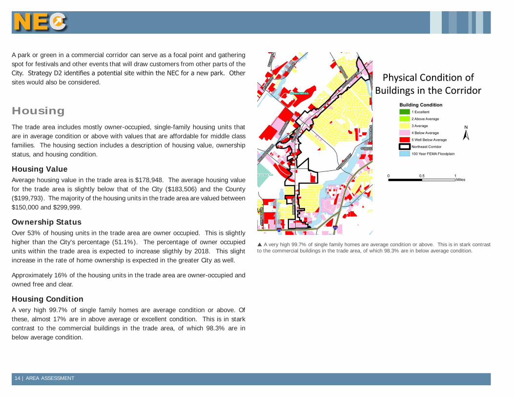
Housing ConditionA very high 99.7% of single family homes are average condition or above. Of these, almost 17% are in above average or excellent condition. This is in stark contrast to the commercial buildings in the trade area, of which 98.3% are in below average condition.
A very high 99.7% of single family homes are average condition or above. This is in stark contrast to the commercial buildings in the trade area, of which 98.3% are in below average condition.
AREA ASSESSMENT | 15
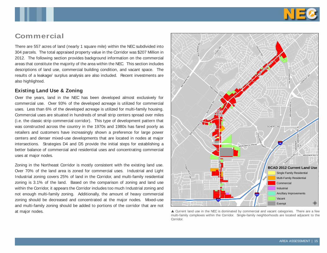
CommercialThere are 557 acres of land (nearly 1 square mile) within the NEC subdivided into 304 parcels. The total appraised property value in the Corridor was $207 Million in 2012. The following section provides background information on the commercial areas that constitute the majority of the area within the NEC. This section includes descriptions of land use, commercial building condition, and vacant space. The results of a leakage/ surplus analysis are also included. Recent investments are also highlighted.
Existing Land Use & ZoningOver the years, land in the NEC has been developed almost exclusively for commercial use. Over 93% of the developed acreage is utilized for commercial uses. Less than 6% of the developed acreage is utilized for multi-family housing. Commercial uses are situated in hundreds of small strip centers spread over miles (i.e. the classic strip commercial corridor). This type of development pattern that was constructed across the country in the 1970s and 1980s has fared poorly as retailers and customers have increasingly shown a preference for large power centers and denser mixed-use developments that are located in nodes at major intersections. Strategies D4 and D5 provide the initial steps for establishing a better balance of commercial and residential uses and concentrating commercial uses at major nodes.
Zoning in the Northeast Corridor is mostly consistent with the existing land use. Over 70% of the land area is zoned for commercial uses. Industrial and Light Industrial zoning covers 25% of land in the Corridor, and multi-family residential zoning is 3.1% of the land. Based on the comparison of zoning and land use within the Corridor, it appears the Corridor includes too much Industrial zoning and not enough multi-family zoning. Additionally, the amount of heavy commercial zoning should be decreased and concentrated at the major nodes. Mixed-use and multi-family zoning should be added to portions of the corridor that are not at major nodes.
BULV
ERD
E R
D
WEI
DN
ER R
D N
O'C
ON
NO
R R
D
THOUSAND OAKS
THO
USAN
D O
AKS
NACOGDOCHES RD
STAH
L RD
WE
IDN
ER
RD
N
WE
IDN
ER
RD N
LOOKOUT RD
HIGG
INS RD
WEIDNER RD S
NACOGDOCHES RD
SCHERTZ RD
WURZBACH PRKW
OLD
PE
RR
IN BE
ITE
L
WET
MOR
E RD
BULV
ERDE
RD
RANDOLPH
BV
RANDOLPH BV
STA
RCREST
DR
PE
RR
IN B
EIT
EL
§̈¦35
§̈¦410
§̈¦410
Data Source: City of San Antonio Enterprise GIS, Bexar Metro 911, Bexar Appra isal District
"This Geographic Information System Product received from the City of San Antonio is provided "as is" without warranty of any kind, and the City of San Antonio expressly disclaims all expressed and implied warranties, including but not l imited to the implied warranties of merchantabil ity and fitness for a particular purpose. The City of San Antonio does not warrant, guarantee, or make any representations regarding the use, or the resu lts of the use, of the information provided to you by the City o f San Antonio in terms of correctness, accuracy, rel iabi lity, timel iness or otherwise. The entire risk as to the resul ts and performance of any information obtained from the City of San Antonio is entire ly assumed by the recipient."
"Please contact the City of San Antonio Department for specific determinations."
City of San Antonio Planning Department GIS Manager: Dale Woodruff, [email protected]. Maps may be ordered at (210) 207-7873.
Map Created by: Michael Taylor, AICPMap Creation Date: Map File Location:PDF Filename:
0 0.25 0.50.125Miles NORTHEAST CORRIDOR
BCAD 2012 Current Land Use
BCAD 2012 Current Land UseSingle Family Residential
Multi-Family Residential
Commercial
Industrial
Ancillary Improvements
Vacant
Exempt µ Current land use in the NEC is dominated by commercial and vacant categories. There are a few multi-family complexes within the Corridor. Single-family neighborhoods are located adjacent to the Corridor.
16 | AREA ASSESSMENT
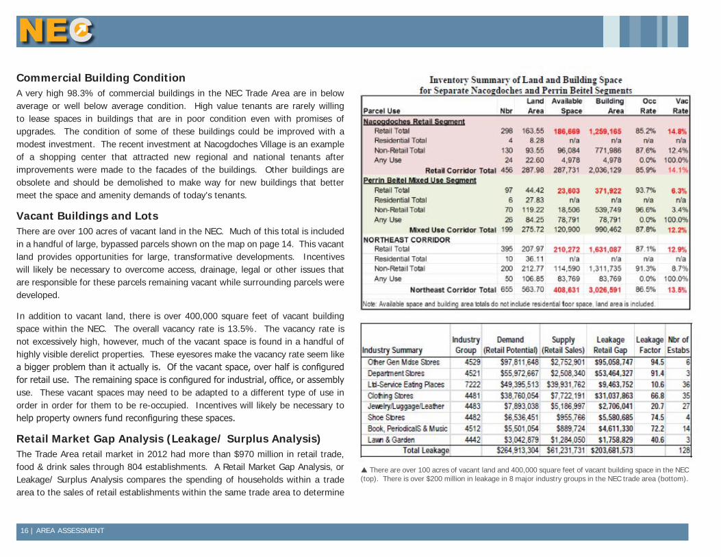
Commercial Building ConditionA very high 98.3% of commercial buildings in the NEC Trade Area are in below average or well below average condition. High value tenants are rarely willing to lease spaces in buildings that are in poor condition even with promises of upgrades. The condition of some of these buildings could be improved with a modest investment. The recent investment at Nacogdoches Village is an example of a shopping center that attracted new regional and national tenants after improvements were made to the facades of the buildings. Other buildings are obsolete and should be demolished to make way for new buildings that better meet the space and amenity demands of today's tenants.
Vacant Buildings and LotsThere are over 100 acres of vacant land in the NEC. Much of this total is included in a handful of large, bypassed parcels shown on the map on page 14. This vacant land provides opportunities for large, transformative developments. Incentives will likely be necessary to overcome access, drainage, legal or other issues that are responsible for these parcels remaining vacant while surrounding parcels were developed.
In addition to vacant land, there is over 400,000 square feet of vacant building space within the NEC. The overall vacancy rate is 13.5%. The vacancy rate is not excessively high, however, much of the vacant space is found in a handful of highly visible derelict properties. These eyesores make the vacancy rate seem like a bigger problem than it actually is. Of the vacant space, over half is configured for retail use. The remaining space is configured for industrial, office, or assembly use. These vacant spaces may need to be adapted to a different type of use in order in order for them to be re-occupied. Incentives will likely be necessary to help property owners fund reconfiguring these spaces.
Retail Market Gap Analysis (Leakage/ Surplus Analysis)The Trade Area retail market in 2012 had more than $970 million in retail trade, food & drink sales through 804 establishments. A Retail Market Gap Analysis, or Leakage/ Surplus Analysis compares the spending of households within a trade area to the sales of retail establishments within the same trade area to determine
There are over 100 acres of vacant land and 400,000 square feet of vacant building space in the NEC (top). There is over $200 million in leakage in 8 major industry groups in the NEC trade area (bottom).
AREA ASSESSMENT | 17
if there is a disparity between spending and sales.
A Leakage/ Surplus Analysis measures the relationship of a retail area with a defined trade area in terms of a gap. The gap can be either negative or positive. A negative gap (surplus) represents a surplus of sales from retailers over the demand from consumers in the trade area. A positive gap (leakage) represents a leakage of sales to other locations outside of the trade area. Leakage indicates that households in the trade area are shopping elsewhere to satisfy their demand for goods. This represents an opportunity for new retailers to establish themselves within the trade area and capture this demand that is currently being met by retailers from outside of the trade area.
There is over $200 million in leakage in 8 major industry groups in the NEC trade area. In other words, households within the trade area are spending $200 million more than what is being sold by area retailers in these industry groups. Over $95 million of this leakage occurred in the Other General Merchanside Stores industry group. A new Wal-Mart in the Trade Area is expected to capture at least $50 million of these sales, but that still leaves demand for additional retailers in this industry group and others. The table on page 16 shows leakage for each of the 8 industry groups.
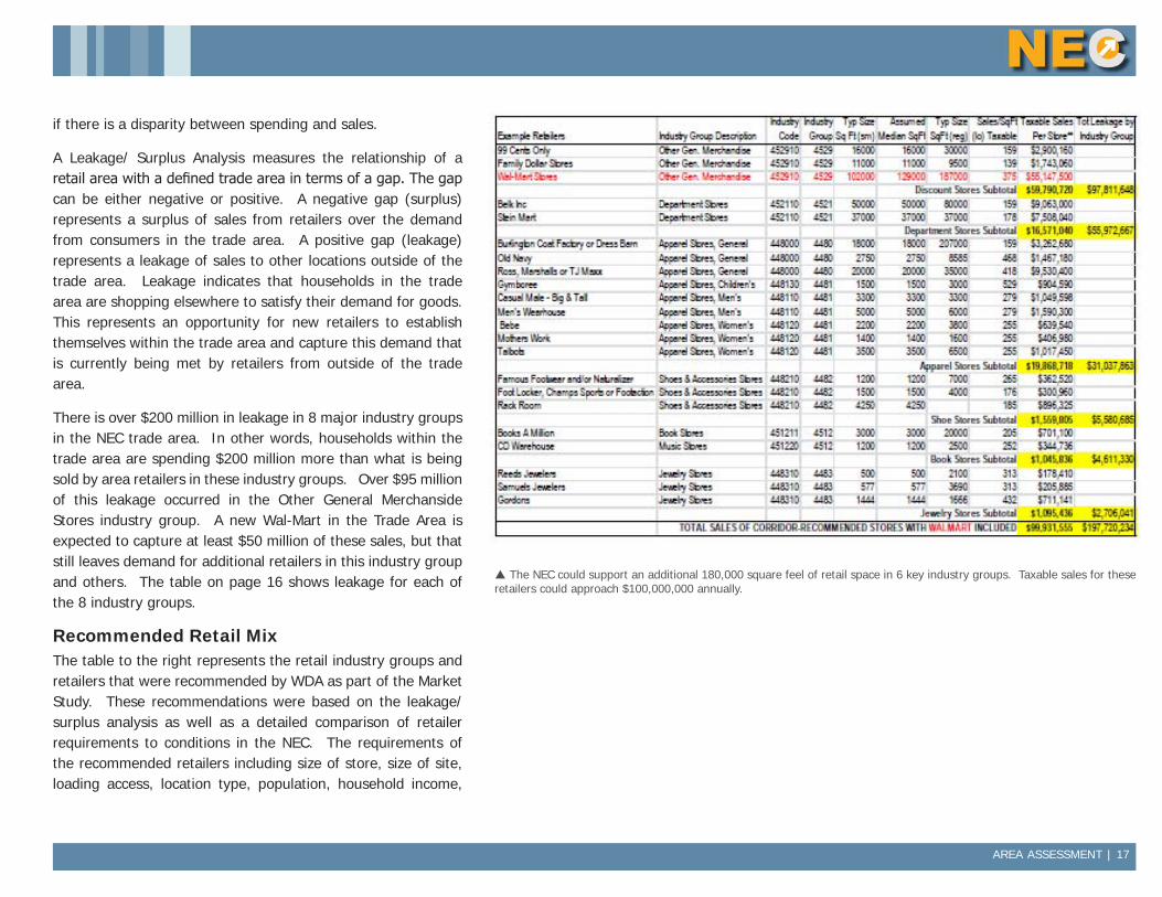
Recommended Retail MixThe table to the right represents the retail industry groups and retailers that were recommended by WDA as part of the Market Study. These recommendations were based on the leakage/ surplus analysis as well as a detailed comparison of retailer requirements to conditions in the NEC. The requirements of the recommended retailers including size of store, size of site, loading access, location type, population, household income,
The NEC could support an additional 180,000 square feel of retail space in 6 key industry groups. Taxable sales for these retailers could approach $100,000,000 annually.
18 | AREA ASSESSMENT
retail synergy, and growth plans are aligned with conditions in the NEC.
The total leakage of the top five recommended industry groups: Discount Stores, Department Stores, Apparel Stores, Shoes & Accessories Stores and Book, Periodical and Music Stores is $195,014,193. The estimated sales of the recommended retailers totals $99,836,119, including an estimate for Walmart of $55,147,500. This represents about ½ of the total leakage, assuming the Corridor will not capture all the leakage due to strong competition from the Forum and other centers not far away, as well as leakage to internet sales.
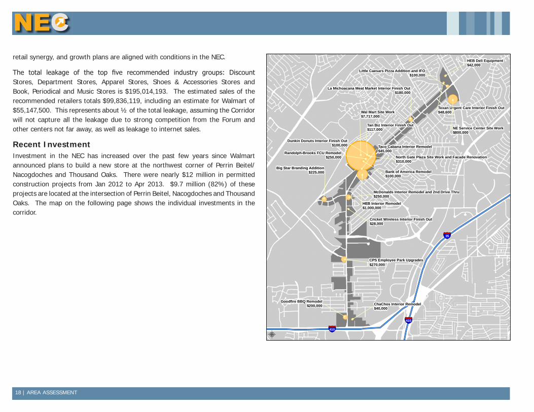
Recent InvestmentInvestment in the NEC has increased over the past few years since Walmart announced plans to build a new store at the northwest corner of Perrin Beitel/ Nacogdoches and Thousand Oaks. There were nearly $12 million in permitted construction projects from Jan 2012 to Apr 2013. $9.7 million (82%) of these projects are located at the intersection of Perrin Beitel, Nacogdoches and Thousand Oaks. The map on the following page shows the individual investments in the corridor.
!(!(
!(
!(
!(
!(
!(!(
!(
!(
!(!(
!(
!(
!(
!(
!(
!(
!(
§̈¦410
§̈¦35
§̈¦410
Bank of America Remodel$100,000
Texan Urgent Care Interior Finish Out$48,600
NE Service Center Site Work$800,000
HEB Deli Equipment$42,000
Big Star Branding Addition$225,000
Little Caesars Pizza Addition and IFO$100,000
ChaChos Interior Remodel$40,000
CPS Employee Park Upgrades$270,000
Goodfire BBQ Remodel$200,000
Cricket Wireless Interior Finish Out$28,000
Tan Biz Interior Finish Out$117,000
Randolph-Brooks FCU Remodel$250,000
HEB Interior Remodel$1,000,000
Taco Cabana Interior Remodel$45,000
La Michoacana Meat Market Interior Finish Out$180,000
McDonalds Interior Remodel and 2nd Drive Thru$250,000
North Gate Plaza Site Work and Facade Renovation$310,000
Dunkin Donuts Interior Finish Out$100,000
Wal Mart Site Work$7,717,000
Data Source: City of San Antonio Enterprise GIS, Bexar Metro 911, Bexar Appra isal District
"This Geographic Information System Product received from the City of San Antonio is provided "as is" without warranty of any kind, and the City of San Antonio expressly disclaims all expressed and implied warranties, including but not l imited to the implied warranties of merchantabil ity and fitness for a particular purpose. The City of San Antonio does not warrant, guarantee, or make any representations regarding the use, or the resu lts of the use, of the information provided to you by the City o f San Antonio in terms of correctness, accuracy, rel iabi lity, timel iness or otherwise. The entire risk as to the resul ts and performance of any information obtained from the City of San Antonio is entire ly assumed by the recipient."
"Please contact the City of San Antonio Department for specific determinations."
City of San Antonio Planning Department GIS Manager: Dale Woodruff, [email protected]. Maps may be ordered at (210) 207-7873.
Map Created by: Michael Taylor, AICPMap Creation Date: Map File Location:PDF Filename:
0 0.3 0.60.15Miles NORTHEAST CORRIDOR
Investment > $25K (2012 & 2013)
µ

STRATEGIC ACTION PLAN | 19
Strategic Action PlanThe market study, overall assessment, and public input were used as the basis for developing 22 strategies to improve conditions in the NEC. The strategies are organized into 4 basic categories: Organization, Design, Marketing, and Business Development. Details on all strategies are provided on subsequent pages.
Strategy Category Page 2014 2015 2016 2017 2018Dependent on TIRZ*
O1 Grow NEC Network Organization 20
O2 Measure Performance Organization 21
D1 TIRZ Designation Design 21
D2 Property Redevelopment Design 21
D3 Landscaping Design 21
D4 Support Zoning Changes Design 22
D5 Design Guidelines Design 22
D6 Design Assistance Design 22
D7 NEC Adopt-A-Spot Litter Control Program Design 22
D8 Top 10 Improvement Opportunities Design 23
D9 Beautification Award Design 23
D10 Facade Grant Design 23
D11 Neighborhood Signage Grant Design 23
D12 Multi-Family Rehab Program Design 23
M1 Enhance Marketing Material Marketing 24
M2 Outreach to Realtors Marketing 24
M3 News Article Submissions Marketing 24
M4 Community Meetings/ Press Conferences Marketing 24
M5 Chamber Outreach Marketing 24
B1 Support Northeast Neighborhood Alliance Business Development 25
B2 Provide Real Estate Listings Business Development 25
B3 Business Attraction Business Development 25
*These strategies are dependent on TIRZ or other source of dedicated revenue.
20 | STRATEGIC ACTION PLAN
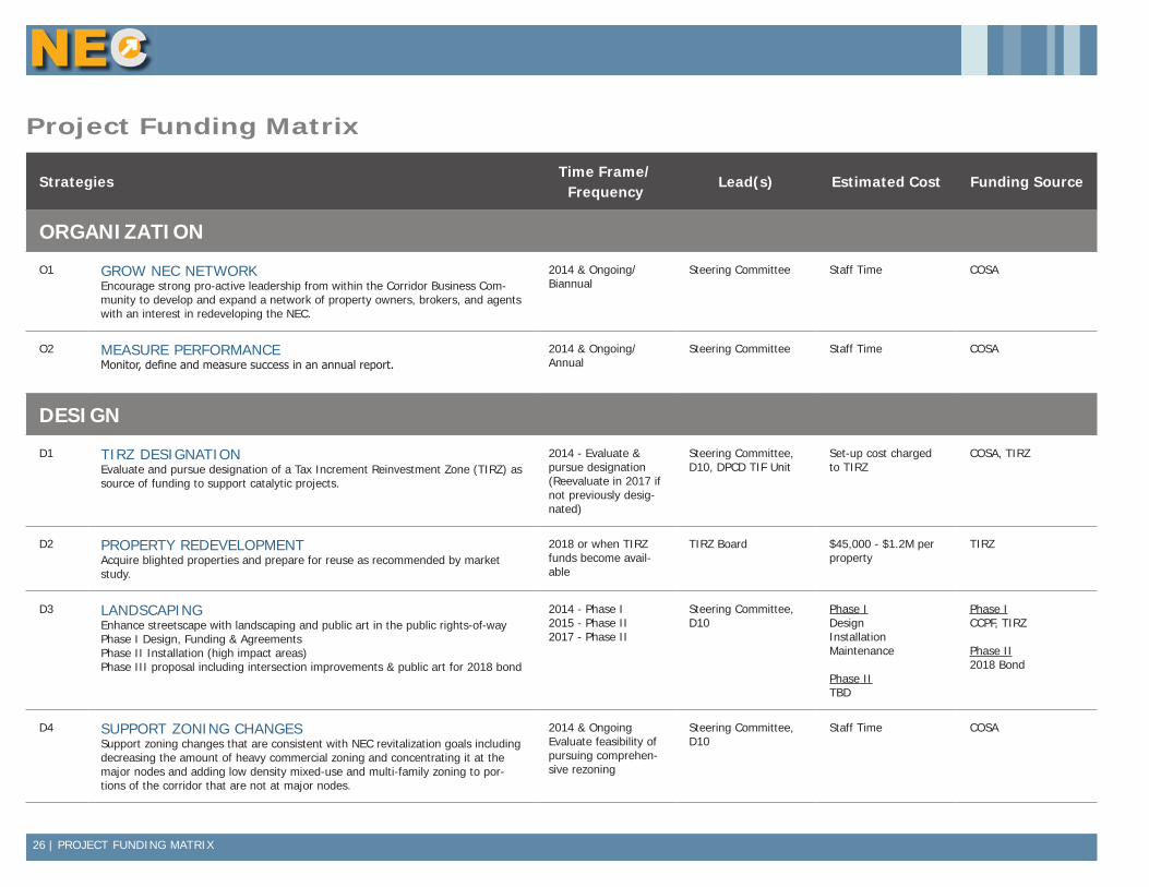
Organization
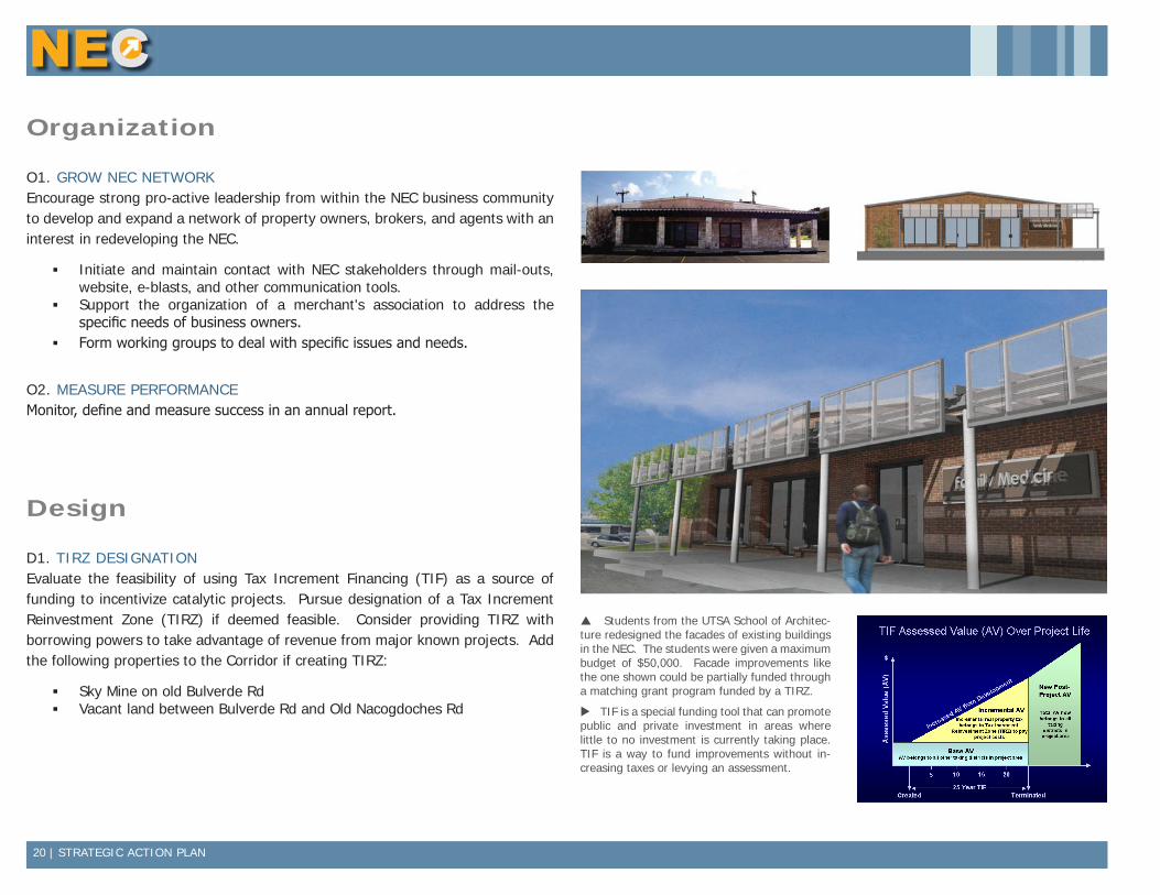
O1. GROW NEC NETWORKEncourage strong pro-active leadership from within the NEC business community to develop and expand a network of property owners, brokers, and agents with an interest in redeveloping the NEC.
▪ Initiate and maintain contact with NEC stakeholders through mail-outs, website, e-blasts, and other communication tools.
▪ Support the organization of a merchant's association to address the specific needs of business owners.
▪ Form working groups to deal with specific issues and needs.
O2. MEASURE PERFORMANCEMonitor, define and measure success in an annual report.
Design
D1. TIRZ DESIGNATIONEvaluate the feasibility of using Tax Increment Financing (TIF) as a source of funding to incentivize catalytic projects. Pursue designation of a Tax Increment Reinvestment Zone (TIRZ) if deemed feasible. Consider providing TIRZ with borrowing powers to take advantage of revenue from major known projects. Add the following properties to the Corridor if creating TIRZ:
▪ Sky Mine on old Bulverde Rd ▪ Vacant land between Bulverde Rd and Old Nacogdoches Rd
Students from the UTSA School of Architec-ture redesigned the facades of existing buildings in the NEC. The students were given a maximum budget of $50,000. Facade improvements like the one shown could be partially funded through a matching grant program funded by a TIRZ.
TIF is a special funding tool that can promote public and private investment in areas where little to no investment is currently taking place. TIF is a way to fund improvements without in-creasing taxes or levying an assessment.
STRATEGIC ACTION PLAN | 21
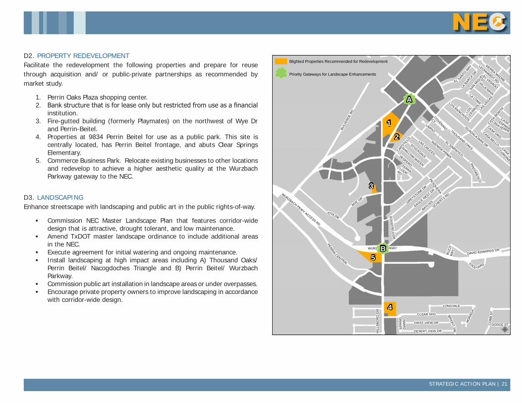
D2. PROPERTY REDEVELOPMENTFacilitate the redevelopment the following properties and prepare for reuse through acquisition and/ or public-private partnerships as recommended by market study.
1. Perrin Oaks Plaza shopping center.2. Bank structure that is for lease only but restricted from use as a financial
institution.3. Fire-gutted building (formerly Playmates) on the northwest of Wye Dr
and Perrin-Beitel.4. Properties at 9834 Perrin Beitel for use as a public park. This site is
centrally located, has Perrin Beitel frontage, and abuts Clear Springs Elementary.
5. Commerce Business Park. Relocate existing businesses to other locations and redevelop to achieve a higher aesthetic quality at the Wurzbach Parkway gateway to the NEC.
D3. LANDSCAPINGEnhance streetscape with landscaping and public art in the public rights-of-way.
▪ Commission NEC Master Landscape Plan that features corridor-wide design that is attractive, drought tolerant, and low maintenance.
▪ Amend TxDOT master landscape ordinance to include additional areas in the NEC.
▪ Execute agreement for initial watering and ongoing maintenance. ▪ Install landscaping at high impact areas including A) Thousand Oaks/
Perrin Beitel/ Nacogdoches Triangle and B) Perrin Beitel/ Wurzbach Parkway.
▪ Commission public art installation in landscape areas or under overpasses. ▪ Encourage private property owners to improve landscaping in accordance
with corridor-wide design.
DAVID EDWARDS DR
LEONHARDT RD
WURZBACH PKWY
CASA BONITA
AVENIDA PRIMA
BRIG
HT
VW
LOS
CERROS
SAN MIG
UELLA
S VEG
AS
EL SANTO W
AY
PESQUERA
TERRA LOOP RD
LIMPIOE
DG
EFIE
LD D
R
SP
RIN
G D
AWN
THOUSAND OAKS
CAPOTILLO
HIL
LSB
OR
O D
R
LOS RANCHITOS
CASA BELLO
GREYSTONE DR
IOTA DR
CO
BB
ST
WURZBACH PKWY ACCESS RD
SCHERTZ RD
VESPERO
BUZZ
I W
AY
VILLA NAVA
CASA
CORONA
BULV
ERDE
RD
COVENANT
CT
CLEAR SPG
EL SIMPATICO
CASA ESPANA
LA LOMA
EL VEDADO
ST
DODGE ST
CASA VERDE
PINTORESCO
EAGLE NEST DR
BAYLISS
CASA ORO
SHALLOW WATER
STOCKDALE
GUADALAJARA DRLAS CRUCES
LA BAR
CA DR
LONGVALE
FIRST VIEW DR
WYE DR
DESERT VIEW DR
PERRIN
CENTRAL TOOL YARD
MO
RAG
A
SIERRA MADRE
Data Source: City of San Antonio Enterprise GIS, Bexar Metro 911, Bexar Appra isal District
"This Geographic Information System Product received from the City of San Antonio is provided "as is" without warranty of any kind, and the City of San Antonio expressly disclaims all expressed and implied warranties, including but not l imited to the implied warranties of merchantabil ity and fitness for a particular purpose. The City of San Antonio does not warrant, guarantee, or make any representations regarding the use, or the resu lts of the use, of the information provided to you by the City o f San Antonio in terms of correctness, accuracy, rel iabi lity, timel iness or otherwise. The entire risk as to the resul ts and performance of any information obtained from the City of San Antonio is entire ly assumed by the recipient."
"Please contact the City of San Antonio Department for specific determinations."
City of San Antonio Planning Department GIS Manager: Dale Woodruff, [email protected]. Maps may be ordered at (210) 207-7873.
Map Created by: Michael Taylor, AICPMap Creation Date: Map File Location:PDF Filename:
0 0.1 0.20.05Miles NORTHEAST CORRIDOR
Properties Recommendedfor Redevelopment
µ
nm
nm
Blighted Properties Recommended for Redevelopment
nm Priority Gateways for Landscape Enhancements
1
2
3
4
5
A
B
22 | STRATEGIC ACTION PLAN
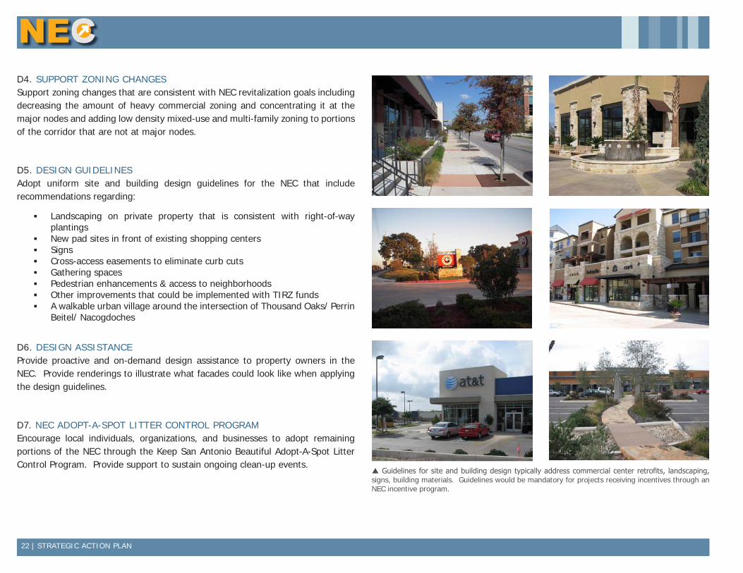
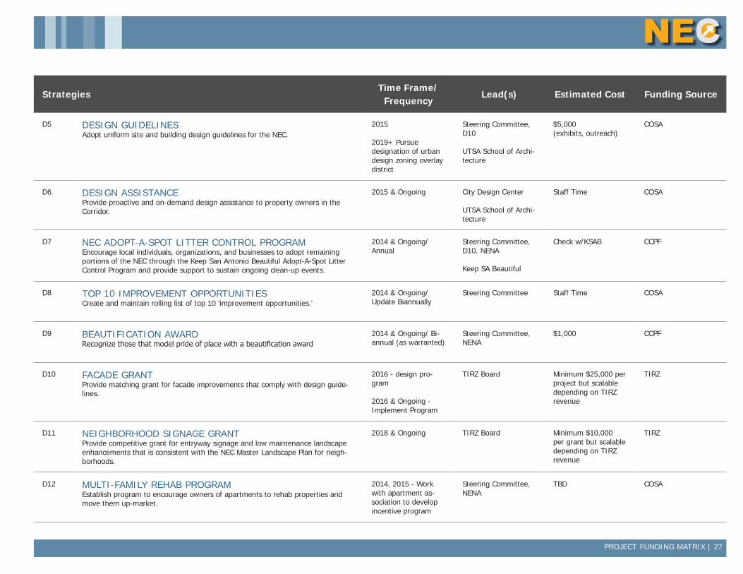
D4. SUPPORT ZONING CHANGESSupport zoning changes that are consistent with NEC revitalization goals including decreasing the amount of heavy commercial zoning and concentrating it at the major nodes and adding low density mixed-use and multi-family zoning to portions of the corridor that are not at major nodes.
D5. DESIGN GUIDELINESAdopt uniform site and building design guidelines for the NEC that include recommendations regarding:
▪ Landscaping on private property that is consistent with right-of-way plantings
▪ New pad sites in front of existing shopping centers ▪ Signs ▪ Cross-access easements to eliminate curb cuts ▪ Gathering spaces ▪ Pedestrian enhancements & access to neighborhoods ▪ Other improvements that could be implemented with TIRZ funds ▪ A walkable urban village around the intersection of Thousand Oaks/ Perrin
Beitel/ Nacogdoches
D6. DESIGN ASSISTANCEProvide proactive and on-demand design assistance to property owners in the NEC. Provide renderings to illustrate what facades could look like when applying the design guidelines.
D7. NEC ADOPT-A-SPOT LITTER CONTROL PROGRAMEncourage local individuals, organizations, and businesses to adopt remaining portions of the NEC through the Keep San Antonio Beautiful Adopt-A-Spot Litter Control Program. Provide support to sustain ongoing clean-up events.
Guidelines for site and building design typically address commercial center retrofits, landscaping, signs, building materials. Guidelines would be mandatory for projects receiving incentives through an NEC incentive program.
STRATEGIC ACTION PLAN | 23
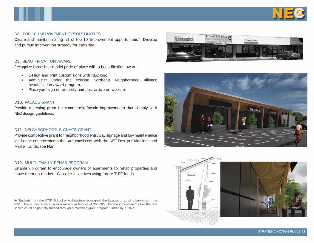
D8. TOP 10 IMPROVEMENT OPPORTUNITIESCreate and maintain rolling list of top 10 'improvement opportunities.' Develop and pursue intervention strategy for each site.
D9. BEAUTIFICATION AWARDRecognize those that model pride of place with a beautification award.
▪ Design and print custom signs with NEC logo. ▪ Administer under the existing Northeast Neighborhood Alliance
beautification award program. ▪ Place yard sign on property and post article on website.
D10. FACADE GRANTProvide matching grant for commercial facade improvements that comply with NEC design guidelines.
D11. NEIGHBORHOOD SIGNAGE GRANTProvide competitive grant for neighborhood entryway signage and low maintenance landscape enhancements that are consistent with the NEC Design Guidelines and Master Landscape Plan.
D12. MULTI-FAMILY REHAB PROGRAMEstablish program to encourage owners of apartments to rehab properties and move them up-market. Consider incentives using future TIRZ funds.
Students from the UTSA School of Architecture redesigned the facades of existing buildings in the NEC. The students were given a maximum budget of $50,000. Facade improvements like the one shown could be partially funded through a matching grant program funded by a TIRZ.
24 | STRATEGIC ACTION PLAN
Marketing
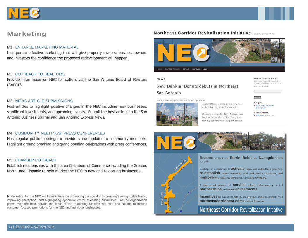
M1. ENHANCE MARKETING MATERIALIncorporate effective marketing that will give property owners, business owners and investors the confidence the proposed redevelopment will happen.
M2. OUTREACH TO REALTORSProvide information on NEC to realtors via the San Antonio Board of Realtors (SABOR).
M3. NEWS ARTICLE SUBMISSIONSPost articles to highlight positive changes in the NEC including new businesses, significant investments, and upcoming events. Submit the best articles to the San Antonio Business Journal and San Antonio Express News.
M4. COMMUNITY MEETINGS/ PRESS CONFERENCESHost regular public meetings to provide status updates to community members. Highlight ground breaking and grand opening celebrations with press conferences.
M5. CHAMBER OUTREACHEstablish relationships with the area Chambers of Commerce including the Greater, North, and Hispanic to help market the NEC to new and relocating businesses.
News | Northeast Corridor Revitalization Initiative
http://northeastcorridorsa.com/news/[9/12/2013 2:12:45 PM]
Northeast Corridor Revitalization Initiative
News
New Dunkin’ Donuts debuts in NortheastSan AntonioSan Antonio Business Journal, Tricia Lynn Silva
Dunkin’ Donuts is rolling out a new storeon Tuesday, July 23 in San Antonio.
The store is located at 12311 NacogdochesRoad on the Northeast Side. The grand-opening festivities will take place at noon.
The Nacogdoches store is one of several thatwill be owned and operated by locally basedPSP Franchising LLC. The owners behindPSP are father-and-son team Kishore and
Prashant Samtani.
The Nacogdoches store is one of four restaurants that PSP hopes to open over the nextseveral years, say the two men, who spoke with the Business Journal last May about theirplans with the Dunkin’ brand.
The agreement with Dunkin’s Brands Group Inc. calls for PSP to open four restaurants,Prashant Samtani stated. Both he and his father, however, expressed confidence that thepotential for the brand and PSP would go beyond four stores.
“We’re not going to wait four years,” Kishore Samtani stated. “We know the potential ofthis brand.”
The Nacogdoches store is the fourth Dunkin’ Donuts in San Antonio. A fifth is expectedto open in the city of Windcrest at the end of this month.
Follow Blog via EmailEnter your email address to followthis blog and receive notifications ofnew posts by email.
BlogrollPlanning & CommunityDevelopment
Recent PostsWelcome! April 12, 2013
perrin beitel | nacogdoches
Home Business Directory Contact Incentives News
Follow “NortheastCorridor RevitalizationInitiative”Get every new post deliveredto your Inbox.
Follow
Follow
Enter your email address
Sign me up
§̈¦410
§̈¦35
§̈¦410
µData Source: City of San Antonio Enterprise GIS, Bexar Metro 911, Bexar Appra isal District
"This Geographic Information System Product received from the City of San Antonio is provided "as is" without warranty of any kind, and the City of San Antonio expressly disclaims all expressed and implied warranties, including but not l imited to the implied warranties of merchantabil ity and fitness for a particular purpose. The City of San Antonio does not warrant, guarantee, or make any representations regarding the use, or the resu lts of the use, of the information provided to you by the City o f San Antonio in terms of correctness, accuracy, rel iabi lity, timel iness or otherwise. The entire risk as to the resul ts and performance of any information obtained from the City of San Antonio is entire ly assumed by the recipient."
"Please contact the City of San Antonio Department for specific determinations."
Map Created by: Michael Taylor, AICPMap Creation Date: May 8, 2013Map File Location: K:\00001 - Communi ty Development Division\Corridor Reinvestment\Northeast Corridor\MapsPDF Filename: NEC_BoundaryMap
0 0.25 0.50.125Miles NORTHEAST CORRIDOR
Boundary Map
Perr
in B
eite
lPe
rrin
Bei
tel
Nacog
doch
es
Nacog
doch
esRestore vitality to the Perrin Beitel and Nacogdoches corridors.
Capitalize on opportunities to activate vacant and underutilized properties,
re-establish community-serving retail and service businesses, and
improve the appearance of buildings, signs, and parking lots.
A place-based program of service delivery enhancements, tactical
partnerships, and targeted investments.
Incentives are available to help you improve your commercial property. Visit
northeastcorridorsa.com for more information.
Northeast Corridor Revitalization Initiative
§̈¦410
§̈¦35
§̈¦410
µData Source: City of San Antonio Enterprise GIS, Bexar Metro 911, Bexar Appra isal District
"This Geographic Information System Product received from the City of San Antonio is provided "as is" without warranty of any kind, and the City of San Antonio expressly disclaims all expressed and implied warranties, including but not l imited to the implied warranties of merchantabil ity and fitness for a particular purpose. The City of San Antonio does not warrant, guarantee, or make any representations regarding the use, or the resu lts of the use, of the information provided to you by the City o f San Antonio in terms of correctness, accuracy, rel iabi lity, timel iness or otherwise. The entire risk as to the resul ts and performance of any information obtained from the City of San Antonio is entire ly assumed by the recipient."
"Please contact the City of San Antonio Department for specific determinations."
Map Created by: Michael Taylor, AICPMap Creation Date: May 8, 2013Map File Location: K:\00001 - Communi ty Development Division\Corridor Reinvestment\Northeast Corridor\MapsPDF Filename: NEC_BoundaryMap
0 0.25 0.50.125Miles NORTHEAST CORRIDOR
Boundary Map
Perr
in B
eite
lPe
rrin
Bei
tel
Nacog
doch
es
Nacog
doch
esRestore vitality to the Perrin Beitel and Nacogdoches corridors.
Capitalize on opportunities to activate vacant and underutilized properties,
re-establish community-serving retail and service businesses, and
improve the appearance of buildings, signs, and parking lots.
A place-based program of service delivery enhancements, tactical
partnerships, and targeted investments.
Incentives are available to help you improve your commercial property. Visit
northeastcorridorsa.com for more information.
Northeast Corridor Revitalization Initiative
Marketing for the NEC will focus initially on promoting the corridor by creating a recognizable brand, improving perception, and highlighting opportunities for relocating businesses. As the organization grows over the next decade the focus of the marketing function will shift and expand to include customer-focused promotions for the NEC and individual businesses.
STRATEGIC ACTION PLAN | 25
Business Development
B1. SUPPORT NORTHEAST NEIGHBORHOOD ALLIANCESupport NENA on the following issues and others that arise.
▪ Facilitate turn over of vacant houses in single-family neighborhoods ▪ Strengthen neighborhood associations ▪ Minimize negative impact of vacant lots in residential areas ▪ Code enforcement
B2. PROVIDE REAL ESTATE LISTINGSMaintain an inventory of active listings of properties that are for sale or lease. Provide a map of locations and lease rates and/ or asking prices as available. Post to website.
B3. BUSINESS ATTRACTIONRecruit businesses from the following Industry Groups as recommended by market study:
RETAIL ▪ General Merchandise Stores, including Discount Stores ▪ Department Stores ▪ Apparel Stores ▪ Shoe Stores ▪ Book, Periodical & Music Stores
NON-RETAIL ▪ Multi-Family - First priority is to assist and facilitate the rehabilitation and/
or replacement of existing multi-family units. Second priority is to support new multi-family units near proposed Bus Rapid Transit (BRT) stations or as part of redevelopment projects that eliminate blight. See market study for potential sites.
▪ Call centers ▪ Alamo Colleges/ Technical School/ Trade School
SPECIALTY ▪ Personal and business service (child care, laundromat, small medical
clinics) and casual dining restaurants in the mixed-use segment ▪ Unique themed destination restaurant in an appropriate location in the
Retail Segment ▪ Incubator for start-up businesses ▪ CPS Energy Service Center ▪ VA Clinic
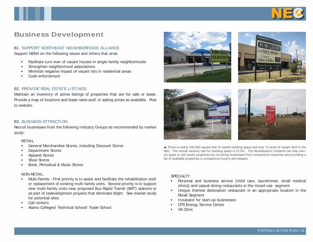
There is nearly 240,000 square feet of vacant building space and over 72 acres of vacant land in the NEC. The overall vacancy rate for building space is 13.5%. The Revitalization Initiative can help own-ers lease or sell vacant properties by recruiting businesses from competitive industries and providing a list of available properties to prospective buyers and lessees.
26 | PROJECT FUNDING MATRIX
StrategiesTime Frame/
FrequencyLead(s) Estimated Cost Funding Source
ORGANIZATION
O1 GROW NEC NETWORKEncourage strong pro-active leadership from within the Corridor Business Com-munity to develop and expand a network of property owners, brokers, and agents with an interest in redeveloping the NEC.
2014 & Ongoing/ Biannual
Steering Committee Staff Time COSA
O2 MEASURE PERFORMANCEMonitor, define and measure success in an annual report.
2014 & Ongoing/ Annual
Steering Committee Staff Time COSA
DESIGN
D1 TIRZ DESIGNATIONEvaluate and pursue designation of a Tax Increment Reinvestment Zone (TIRZ) as source of funding to support catalytic projects.
2014 - Evaluate & pursue designation (Reevaluate in 2017 if not previously desig-nated)
Steering Committee, D10, DPCD TIF Unit
Set-up cost charged to TIRZ
COSA, TIRZ
D2 PROPERTY REDEVELOPMENTAcquire blighted properties and prepare for reuse as recommended by market study.
2018 or when TIRZ funds become avail-able
TIRZ Board $45,000 - $1.2M per property
TIRZ
D3 LANDSCAPINGEnhance streetscape with landscaping and public art in the public rights-of-wayPhase I Design, Funding & AgreementsPhase II Installation (high impact areas)Phase III proposal including intersection improvements & public art for 2018 bond
2014 - Phase I2015 - Phase II2017 - Phase II
Steering Committee, D10
Phase IDesignInstallationMaintenance
Phase IITBD
Phase ICCPF, TIRZ
Phase II2018 Bond
D4 SUPPORT ZONING CHANGESSupport zoning changes that are consistent with NEC revitalization goals including decreasing the amount of heavy commercial zoning and concentrating it at the major nodes and adding low density mixed-use and multi-family zoning to por-tions of the corridor that are not at major nodes.
2014 & OngoingEvaluate feasibility of pursuing comprehen-sive rezoning
Steering Committee, D10
Staff Time COSA
Project Funding Matrix
PROJECT FUNDING MATRIX | 27
StrategiesTime Frame/
FrequencyLead(s) Estimated Cost Funding Source
D5 DESIGN GUIDELINESAdopt uniform site and building design guidelines for the NEC.
2015
2019+ Pursue designation of urban design zoning overlay district
Steering Committee, D10
UTSA School of Archi-tecture
$5,000(exhibits, outreach)
COSA
D6 DESIGN ASSISTANCEProvide proactive and on-demand design assistance to property owners in the Corridor.
2015 & Ongoing City Design Center
UTSA School of Archi-tecture
Staff Time COSA
D7 NEC ADOPT-A-SPOT LITTER CONTROL PROGRAMEncourage local individuals, organizations, and businesses to adopt remaining portions of the NEC through the Keep San Antonio Beautiful Adopt-A-Spot Litter Control Program and provide support to sustain ongoing clean-up events.
2014 & Ongoing/ Annual
Steering Committee, D10, NENA
Keep SA Beautiful
Check w/KSAB CCPF
D8 TOP 10 IMPROVEMENT OPPORTUNITIESCreate and maintain rolling list of top 10 'improvement opportunities.'
2014 & Ongoing/ Update Biannually
Steering Committee Staff Time COSA
D9 BEAUTIFICATION AWARDRecognize those that model pride of place with a beautification award
2014 & Ongoing/ Bi-annual (as warranted)
Steering Committee, NENA
$1,000 CCPF
D10 FACADE GRANTProvide matching grant for facade improvements that comply with design guide-lines.
2016 - design pro-gram
2016 & Ongoing - Implement Program
TIRZ Board Minimum $25,000 per project but scalable depending on TIRZ revenue
TIRZ
D11 NEIGHBORHOOD SIGNAGE GRANTProvide competitive grant for entryway signage and low maintenance landscape enhancements that is consistent with the NEC Master Landscape Plan for neigh-borhoods.
2018 & Ongoing TIRZ Board Minimum $10,000 per grant but scalable depending on TIRZ revenue
TIRZ
D12 MULTI-FAMILY REHAB PROGRAMEstablish program to encourage owners of apartments to rehab properties and move them up-market.
2014, 2015 - Work with apartment as-sociation to develop incentive program
Steering Committee, NENA
TBD COSA
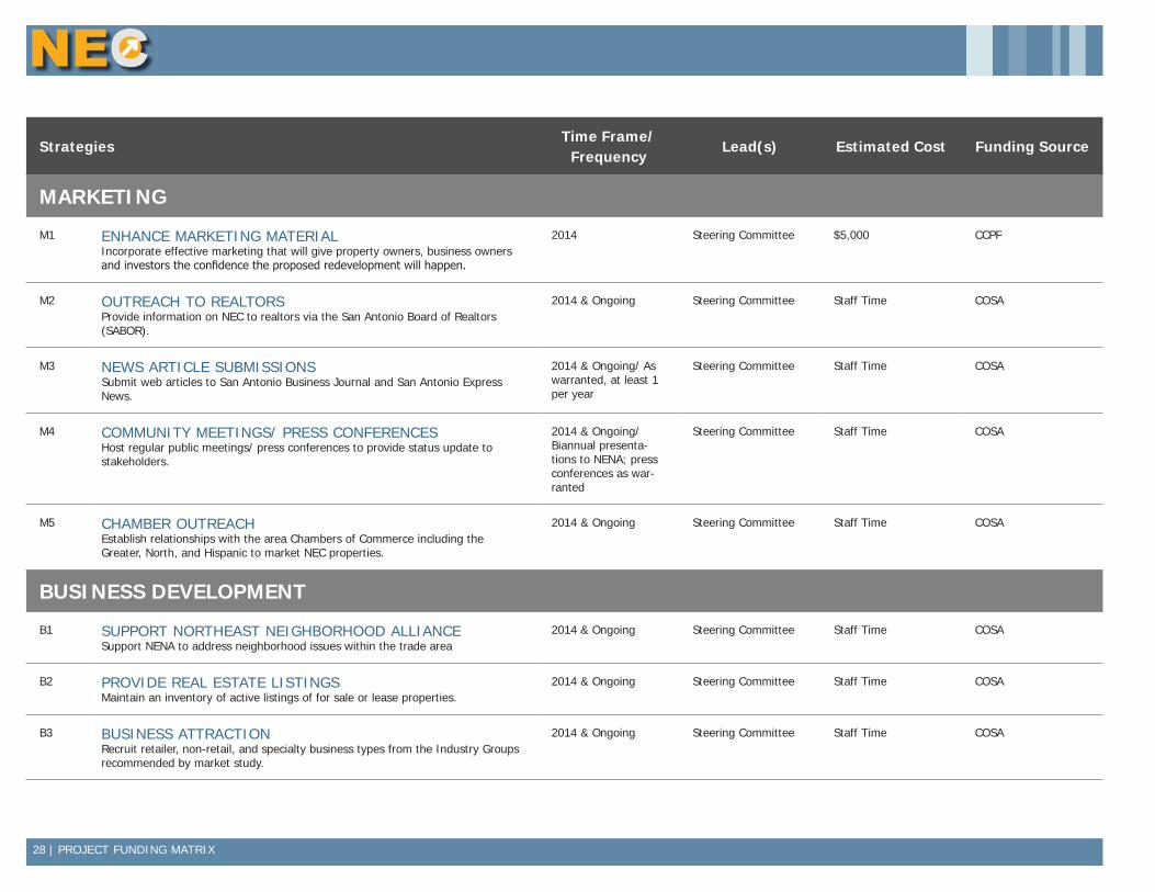
28 | PROJECT FUNDING MATRIX
StrategiesTime Frame/
FrequencyLead(s) Estimated Cost Funding Source
MARKETING
M1 ENHANCE MARKETING MATERIALIncorporate effective marketing that will give property owners, business owners and investors the confidence the proposed redevelopment will happen.
2014 Steering Committee $5,000 CCPF
M2 OUTREACH TO REALTORSProvide information on NEC to realtors via the San Antonio Board of Realtors (SABOR).
2014 & Ongoing Steering Committee Staff Time COSA
M3 NEWS ARTICLE SUBMISSIONSSubmit web articles to San Antonio Business Journal and San Antonio Express News.
2014 & Ongoing/ As warranted, at least 1 per year
Steering Committee Staff Time COSA
M4 COMMUNITY MEETINGS/ PRESS CONFERENCESHost regular public meetings/ press conferences to provide status update to stakeholders.
2014 & Ongoing/ Biannual presenta-tions to NENA; press conferences as war-ranted
Steering Committee Staff Time COSA
M5 CHAMBER OUTREACHEstablish relationships with the area Chambers of Commerce including the Greater, North, and Hispanic to market NEC properties.
2014 & Ongoing Steering Committee Staff Time COSA
BUSINESS DEVELOPMENT
B1 SUPPORT NORTHEAST NEIGHBORHOOD ALLIANCESupport NENA to address neighborhood issues within the trade area
2014 & Ongoing Steering Committee Staff Time COSA
B2 PROVIDE REAL ESTATE LISTINGSMaintain an inventory of active listings of for sale or lease properties.
2014 & Ongoing Steering Committee Staff Time COSA
B3 BUSINESS ATTRACTIONRecruit retailer, non-retail, and specialty business types from the Industry Groups recommended by market study.
2014 & Ongoing Steering Committee Staff Time COSA
| 29
Prepared by the City of San AntonioDepartment of Planning & Community Development