Embed Size (px)
Citation preview
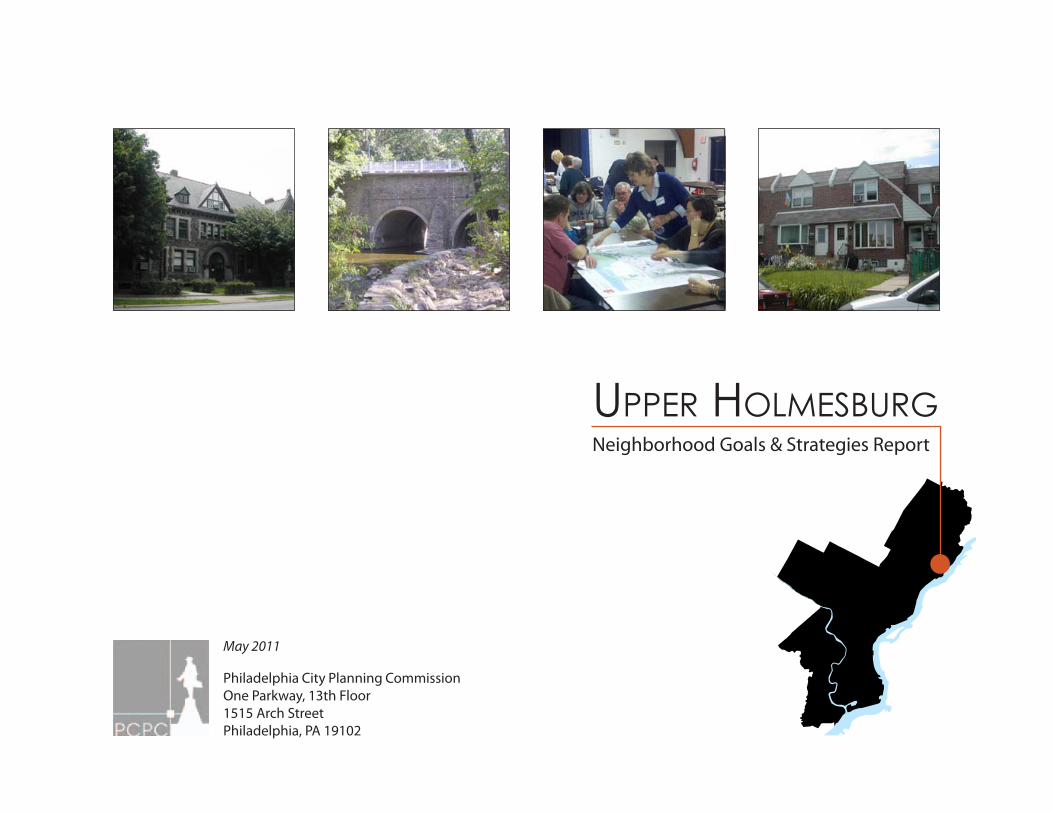
May 2011
Philadelphia City Planning CommissionOne Parkway, 13th Floor1515 Arch StreetPhiladelphia, PA 19102
Upper HolmesbUrgNeighborhood Goals & Strategies Report
Philadelphia City Planning Commission
2
Upper Holmesburg Neighborhood Goals & Strategies Report
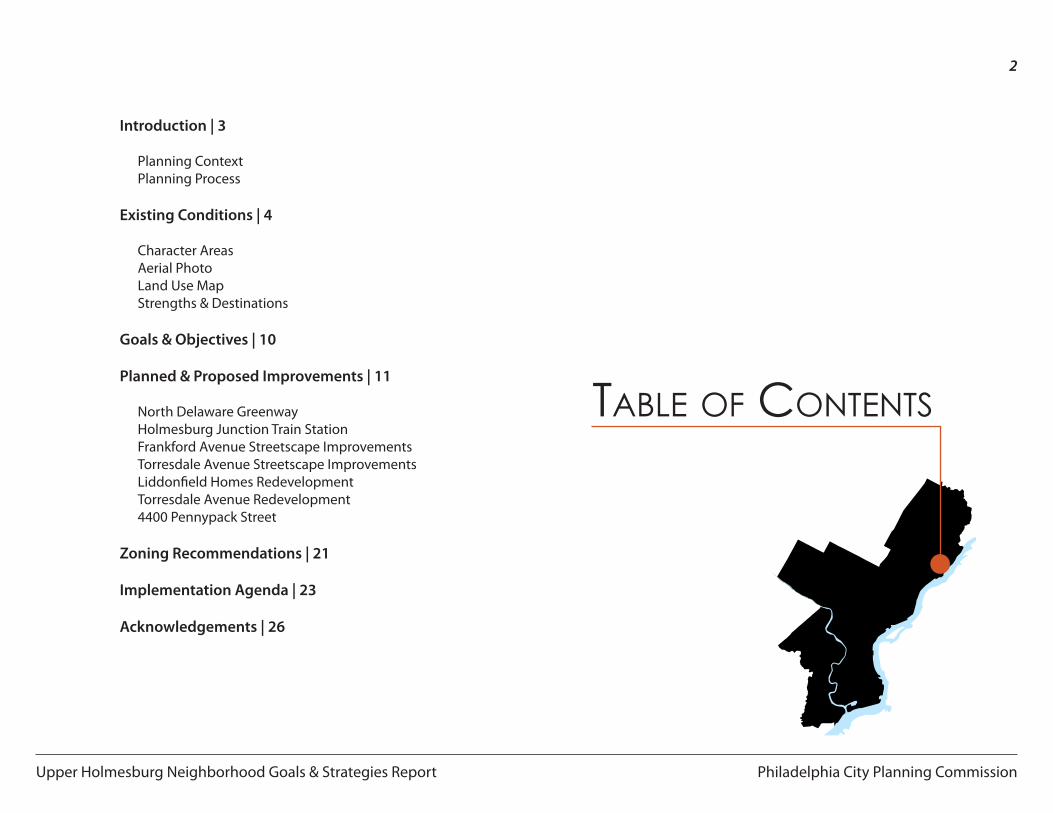
Introduction | 3
Planning ContextPlanning Process
Existing Conditions | 4
Character Areas Aerial PhotoLand Use MapStrengths & Destinations
Goals & Objectives | 10
Planned & Proposed Improvements | 11
North Delaware GreenwayHolmesburg Junction Train StationFrankford Avenue Streetscape ImprovementsTorresdale Avenue Streetscape ImprovementsLiddonfield Homes RedevelopmentTorresdale Avenue Redevelopment4400 Pennypack Street
Zoning Recommendations | 21
Implementation Agenda | 23
Acknowledgements | 26
Table of ConTenTs
Philadelphia City Planning Commission
3
Upper Holmesburg Neighborhood Goals & Strategies Report
Introduction
Planning Context
Upper Holmesburg is located in Northeast Philadelphia adjacent to Pennypack Park, twelve miles from Center City. The neighborhood contains a mix of residential, industrial, and commercial land uses with large areas of publicly-owned, but inaccessible land along the Delaware River waterfront. The residential area of Upper Holmesburg is a fully developed neighborhood with a mix of row houses, twin homes, detached homes, and small apartment buildings. For years, the Liddonfield Homes public housing project divided the area in two and had a deleterious effect on the neighborhood. Before being used as a public housing complex, the 32 acre site was used as military barracks and a summer camp dormitory. The complex contained 463 residential units in 58 buildings. The Philadelphia Housing Authority (PHA) completed demolition of the buildings in 2011; however, previous plans for redevelopment have been abandoned due to the current state of the economy and housing market.
The delay in the redevelopment process presented an opportunity for the Philadelphia City Planning Commission (PCPC) and the PHA to work together with the community to plan for the redevelopment of the Liddonfield Homes site. The PCPC and the community chose to utilize the opportunity to imagine a new future for the neighborhood with greener streets, mixed-use, sustainable redevelopment, and better connections to transit, parks, and the Delaware Riverfront.
Planning Process
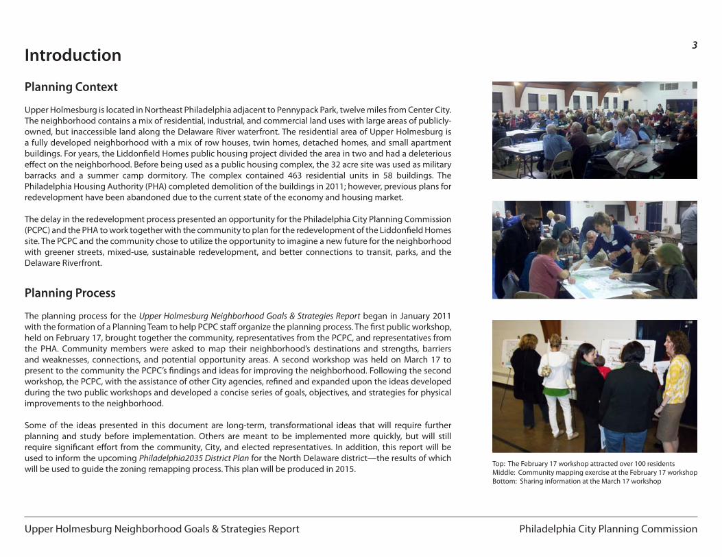
The planning process for the Upper Holmesburg Neighborhood Goals & Strategies Report began in January 2011 with the formation of a Planning Team to help PCPC staff organize the planning process. The first public workshop, held on February 17, brought together the community, representatives from the PCPC, and representatives from the PHA. Community members were asked to map their neighborhood’s destinations and strengths, barriers and weaknesses, connections, and potential opportunity areas. A second workshop was held on March 17 to present to the community the PCPC’s findings and ideas for improving the neighborhood. Following the second workshop, the PCPC, with the assistance of other City agencies, refined and expanded upon the ideas developed during the two public workshops and developed a concise series of goals, objectives, and strategies for physical improvements to the neighborhood.
Some of the ideas presented in this document are long-term, transformational ideas that will require further planning and study before implementation. Others are meant to be implemented more quickly, but will still require significant effort from the community, City, and elected representatives. In addition, this report will be used to inform the upcoming Philadelphia2035 District Plan for the North Delaware district—the results of which will be used to guide the zoning remapping process. This plan will be produced in 2015.
Top: The February 17 workshop attracted over 100 residentsMiddle: Community mapping exercise at the February 17 workshopBottom: Sharing information at the March 17 workshop
Philadelphia City Planning Commission
4
Upper Holmesburg Neighborhood Goals & Strategies Report
Existing Conditions
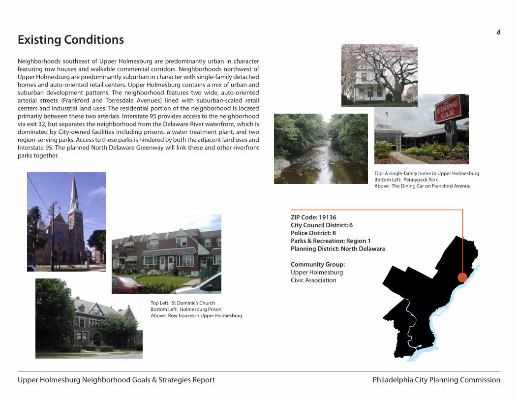
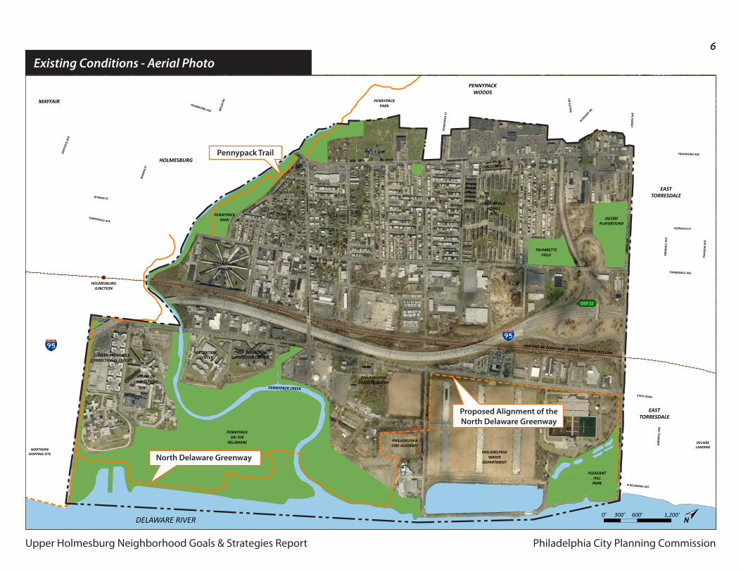
Neighborhoods southeast of Upper Holmesburg are predominantly urban in character featuring row houses and walkable commercial corridors. Neighborhoods northwest of Upper Holmesburg are predominantly suburban in character with single-family detached homes and auto-oriented retail centers. Upper Holmesburg contains a mix of urban and suburban development patterns. The neighborhood features two wide, auto-oriented arterial streets (Frankford and Torresdale Avenues) lined with suburban-scaled retail centers and industrial land uses. The residential portion of the neighborhood is located primarily between these two arterials. Interstate 95 provides access to the neighborhood via exit 32, but separates the neighborhood from the Delaware River waterfront, which is dominated by City-owned facilities including prisons, a water treatment plant, and two region-serving parks. Access to these parks is hindered by both the adjacent land uses and Interstate 95. The planned North Delaware Greenway will link these and other riverfront parks together.
Top Left: St Dominic’s ChurchBottom Left: Holmesburg PrisonAbove: Row houses in Upper Holmesburg
Top: A single-family home in Upper HolmesburgBottom Left: Pennypack ParkAbove: The Dining Car on Frankford Avenue
ZIP Code: 19136City Council District: 6Police District: 8Parks & Recreation: Region 1Planning District: North Delaware
Community Group:Upper HolmesburgCivic Association
Philadelphia City Planning Commission
5
Upper Holmesburg Neighborhood Goals & Strategies Report
Existing Conditions - Character Areas
North of Academy Road
Strahle Street to Academy Road
Pennypack Park to Strahle Street
Torresdale Avenue to State Road
State Road to the Delaware River
Frankford Avenue
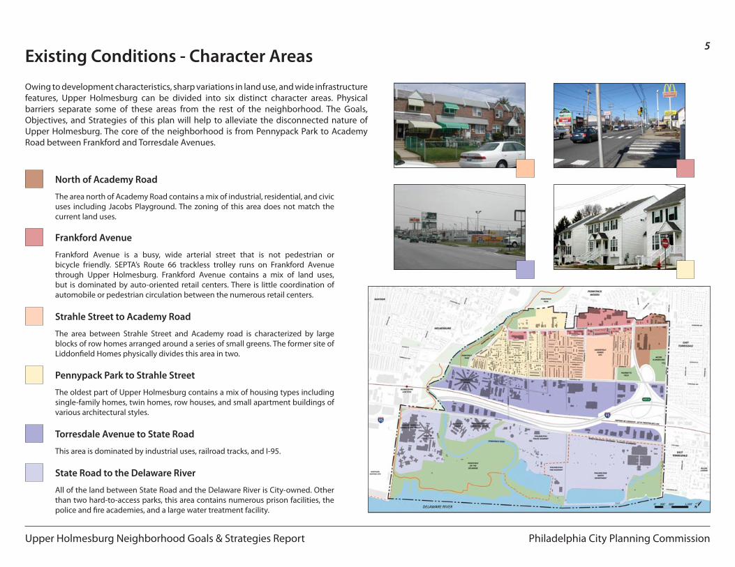
Owing to development characteristics, sharp variations in land use, and wide infrastructure features, Upper Holmesburg can be divided into six distinct character areas. Physical barriers separate some of these areas from the rest of the neighborhood. The Goals, Objectives, and Strategies of this plan will help to alleviate the disconnected nature of Upper Holmesburg. The core of the neighborhood is from Pennypack Park to Academy Road between Frankford and Torresdale Avenues.
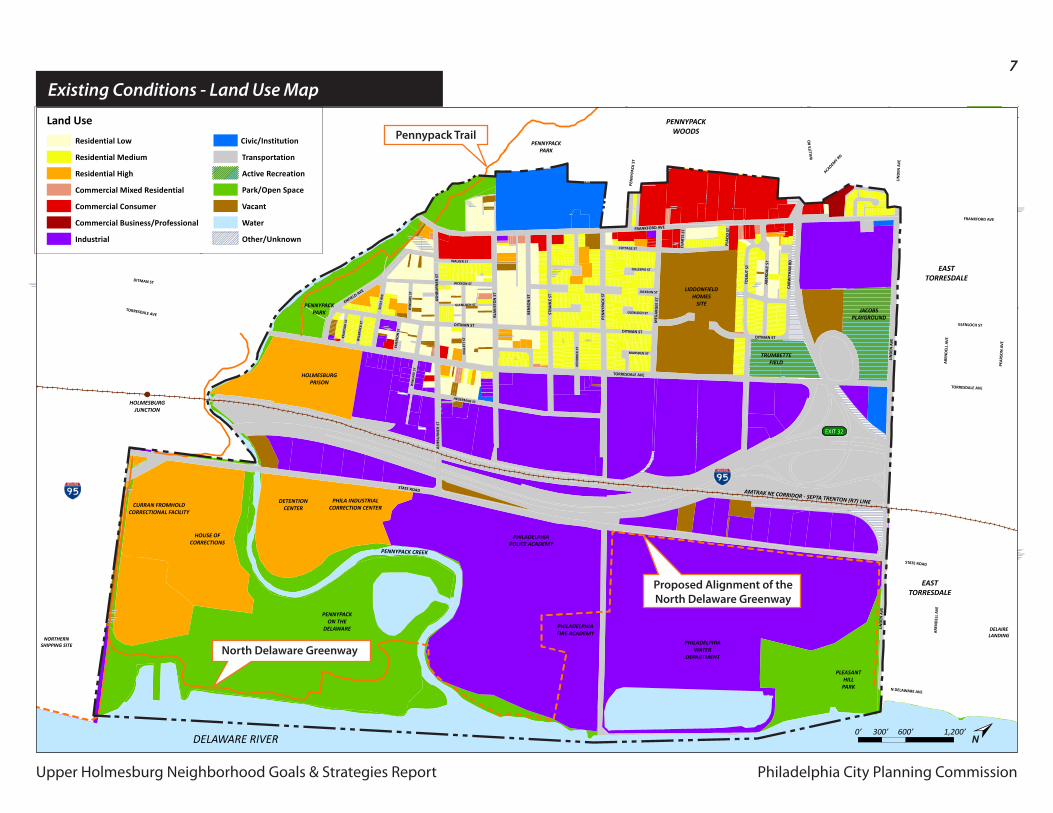
The area north of Academy Road contains a mix of industrial, residential, and civic uses including Jacobs Playground. The zoning of this area does not match the current land uses.
The area between Strahle Street and Academy road is characterized by large blocks of row homes arranged around a series of small greens. The former site of Liddonfield Homes physically divides this area in two.
The oldest part of Upper Holmesburg contains a mix of housing types including single-family homes, twin homes, row houses, and small apartment buildings of various architectural styles.
This area is dominated by industrial uses, railroad tracks, and I-95.
All of the land between State Road and the Delaware River is City-owned. Other than two hard-to-access parks, this area contains numerous prison facilities, the police and fire academies, and a large water treatment facility.
Frankford Avenue is a busy, wide arterial street that is not pedestrian or bicycle friendly. SEPTA’s Route 66 trackless trolley runs on Frankford Avenue through Upper Holmesburg. Frankford Avenue contains a mix of land uses, but is dominated by auto-oriented retail centers. There is little coordination of automobile or pedestrian circulation between the numerous retail centers.
Philadelphia City Planning CommissionUpper Holmesburg Neighborhood Goals & Strategies Report
6
Upper Holmesburg Neighborhood Goals & Strategies Report
February 17, 2011Facilitator:
Workshop 1
Philadelphia CityPlanning Commission
Upper Holmesburg Civic Assoc.
0’ 300’ 600’ 1,200’N
FRANKFORD AVE
FRANKFORD AVE
PEN
NYP
ACK
ST W
ILLI
TS R
D
FRANKFORD AVE
EVA
RTS
ST
PLA
CID
ST
TORRESDALE AVE
TORRESDALE AVE
GLENLOCH ST
N DELAWARE AVE
TORRESDALE AVE
DITMAN ST
STATE ROAD
STATE ROAD
MEG
ARG
EE S
T
TOLB
UT
ST
ABE
RDA
LE S
T
CARW
ITH
AN
RD
DITMAN ST
ACADEMY R
D
LIN
DEN
AV
E
LIN
DEN
AV
E
PEA
RSO
N A
VE
ARE
ND
ELL
AVE
LIN
DEN
AV
E
ARE
ND
ELL
AVE
DITMAN ST
DITMAN ST
GLENLOCH ST
COTTAGE ST
MARSDEN ST
GILLESPIE ST
KEN
DRI
CK S
T
JACKSON ST
PEN
NYP
ACK
ST
STRA
HLE
ST
BEN
SON
ST
BLA
KIST
ON
ST
ASH
BURN
ER S
T
RHAW
N S
T
SHEF
FIEL
D A
VE
WEL
SH R
D
BLEI
GH
AV
E
WALKER ST
JACKSON ST
GLENLOCH ST
HEGERMAN ST
MIL
LETT
ST
WIN
GAT
E ST
WIL
BRO
CK S
T
KRAY
DO
R ST
WIN
GAT
E ST
EMER
SON
ST
SOLL
Y AV
E
ASH
BURN
ER S
T
ENFIELD AVE
AMTRAK NE CORRIDOR - SEPTA TRENTON (R7) LINE
PLEASANTHILLPARK
DELAIRELANDING
PENNYPACK CREEK
NORTHERNSHIPPING SITE
DELAWARE RIVER
HOLMESBURGPRISON
CURRAN FROMHOLDCORRECTIONAL FACILITY
HOUSE OFCORRECTIONS
DETENTIONCENTER
PHILA INDUSTRIALCORRECTION CENTER
PHILADELPHIAWATER
DEPARTMENT
PHILADELPHIAPOLICE ACADEMY
PHILADELPHIAFIRE ACADEMY
LIDDONFIELDHOMES
SITE
PENNYPACKON THE
DELAWARE
PENNYPACKPARK
PENNYPACKPARK
TRUMBETTEFIELD
JACOBSPLAYGROUND
HOLMESBURGJUNCTION
EASTTORRESDALE
EASTTORRESDALE
PENNYPACKWOODS
HOLMESBURG
MAYFAIR
EXIT 32
Existing Conditions - Aerial Photo
Proposed Alignment of theNorth Delaware Greenway
North Delaware Greenway
Pennypack Trail
Philadelphia City Planning CommissionUpper Holmesburg Neighborhood Goals & Strategies Report
7
Upper Holmesburg Neighborhood Goals & Strategies Report
February 17, 2011 2010 Generalized Land Use
Philadelphia CityPlanning Commission
Upper Holmesburg Civic Assoc.
FRANKFORD AVE
FRANKFORD AVE
PEN
NYP
ACK
ST W
ILLI
TS R
D
FRANKFORD AVE
EVA
RTS
ST
PLA
CID
ST
TORRESDALE AVE
TORRESDALE AVE
GLENLOCH ST
N DELAWARE AVE
TORRESDALE AVE
DITMAN ST
STATE ROAD
STATE ROAD
MEG
ARG
EE S
T
TOLB
UT
ST
ABE
RDA
LE S
T
CARW
ITH
AN
RD
DITMAN ST
ACADEMY R
D
LIN
DEN
AV
E
LIN
DEN
AV
E
PEA
RSO
N A
VE
ARE
ND
ELL
AVE
LIN
DEN
AV
E
ARE
ND
ELL
AVE
DITMAN ST
DITMAN ST
GLENLOCH ST
COTTAGE ST
MARSDEN ST
GILLESPIE ST
KEN
DRI
CK S
T
JACKSON ST
PEN
NYP
ACK
ST
STRA
HLE
ST
BEN
SON
ST
BLA
KIST
ON
ST
ASH
BURN
ER S
T
RHAW
N S
T
SHEF
FIEL
D A
VE
WEL
SH R
D
BLEI
GH
AV
E
WALKER ST
JACKSON ST
GLENLOCH ST
HEGERMAN ST
MIL
LETT
ST
WIN
GAT
E ST
WIL
BRO
CK S
T
KRAY
DO
R ST
WIN
GAT
E ST
EMER
SON
ST
SOLL
Y AV
E
ASH
BURN
ER S
T
ENFIELD AVE
AMTRAK NE CORRIDOR - SEPTA TRENTON (R7) LINE
PLEASANTHILLPARK
DELAIRELANDING
PENNYPACK CREEK
NORTHERNSHIPPING SITE
DELAWARE RIVER
HOLMESBURGPRISON
CURRAN FROMHOLDCORRECTIONAL FACILITY
HOUSE OFCORRECTIONS
DETENTIONCENTER
PHILA INDUSTRIALCORRECTION CENTER
PHILADELPHIAWATER
DEPARTMENT
PHILADELPHIAPOLICE ACADEMY
PHILADELPHIAFIRE ACADEMY
LIDDONFIELDHOMES
SITE
PENNYPACKON THE
DELAWARE
PENNYPACKPARK
PENNYPACKPARK
TRUMBETTEFIELD
JACOBSPLAYGROUND
HOLMESBURGJUNCTION
EASTTORRESDALE
EASTTORRESDALE
PENNYPACKWOODS
HOLMESBURG
MAYFAIR
EXIT 32
0’ 300’ 600’ 1,200’N
Land Use
Residential Low
Residential Medium
Residential High
Commercial Mixed Residential
Commercial Consumer
Commercial Business/Professional
Industrial
Civic/Institution
Transportation
Active Recreation
Park/Open Space
Vacant
Water
Other/Unknown
Pennypack Trail
Existing Conditions - Land Use Map
Proposed Alignment of theNorth Delaware Greenway
North Delaware Greenway
Philadelphia City Planning CommissionUpper Holmesburg Neighborhood Goals & Strategies Report
8
Upper Holmesburg Neighborhood Goals & Strategies Report
March 17, 2011 Neighborhood Strengths & Destinations
Philadelphia CityPlanning Commission
Upper Holmesburg Civic Assoc.
FRANKFORD AVE
FRANKFORD AVE
PEN
NYP
ACK
ST W
ILLI
TS R
D
FRANKFORD AVE
EVA
RTS
ST
PLA
CID
ST
TORRESDALE AVE
TORRESDALE AVE
GLENLOCH ST
N DELAWARE AVE
TORRESDALE AVE
DITMAN ST
STATE ROAD
STATE ROAD
MEG
ARG
EE S
T
TOLB
UT
ST
ABE
RDA
LE S
T
CARW
ITH
AN
RD
DITMAN ST
ACADEMY R
D
LIN
DEN
AV
E
LIN
DEN
AV
E
PEA
RSO
N A
VE
ARE
ND
ELL
AVE
LIN
DEN
AV
E
ARE
ND
ELL
AVE
DITMAN ST
DITMAN ST
GLENLOCH ST
COTTAGE ST
MARSDEN ST
GILLESPIE ST
KEN
DRI
CK S
T
JACKSON ST
PEN
NYP
ACK
ST
STRA
HLE
ST
BEN
SON
ST
BLA
KIST
ON
ST
ASH
BURN
ER S
T
RHAW
N S
T
SHEF
FIEL
D A
VE
WEL
SH R
D
BLEI
GH
AV
E
WALKER ST
JACKSON ST
GLENLOCH ST
HEGERMAN ST
MIL
LETT
ST
WIN
GAT
E ST
WIL
BRO
CK S
T
KRAY
DO
R ST
WIN
GAT
E ST
EMER
SON
ST
SOLL
Y AV
E
ASH
BURN
ER S
T
ENFIELD AVE
AMTRAK NE CORRIDOR - SEPTA TRENTON (R7) LINE
DELAIRELANDING
PENNYPACK CREEK
NORTHERNSHIPPING SITE
DELAWARE RIVER
HOLMESBURGPRISON
CURRAN FROMHOLDCORRECTIONAL FACILITY
HOUSE OFCORRECTIONS
DETENTIONCENTER
PHILA INDUSTRIALCORRECTION CENTER
PHILADELPHIAWATER
DEPARTMENT
PHILADELPHIAPOLICE ACADEMY
PHILADELPHIAFIRE ACADEMY
LIDDONFIELDHOMES
SITE
EASTTORRESDALE
EASTTORRESDALE
PENNYPACKWOODS
HOLMESBURG
MAYFAIR
EXIT 32
0’ 300’ 600’ 1,200’N
PENNYPACKON THE
DELAWARE
PENNYPACKPARK
PENNYPACKPARK
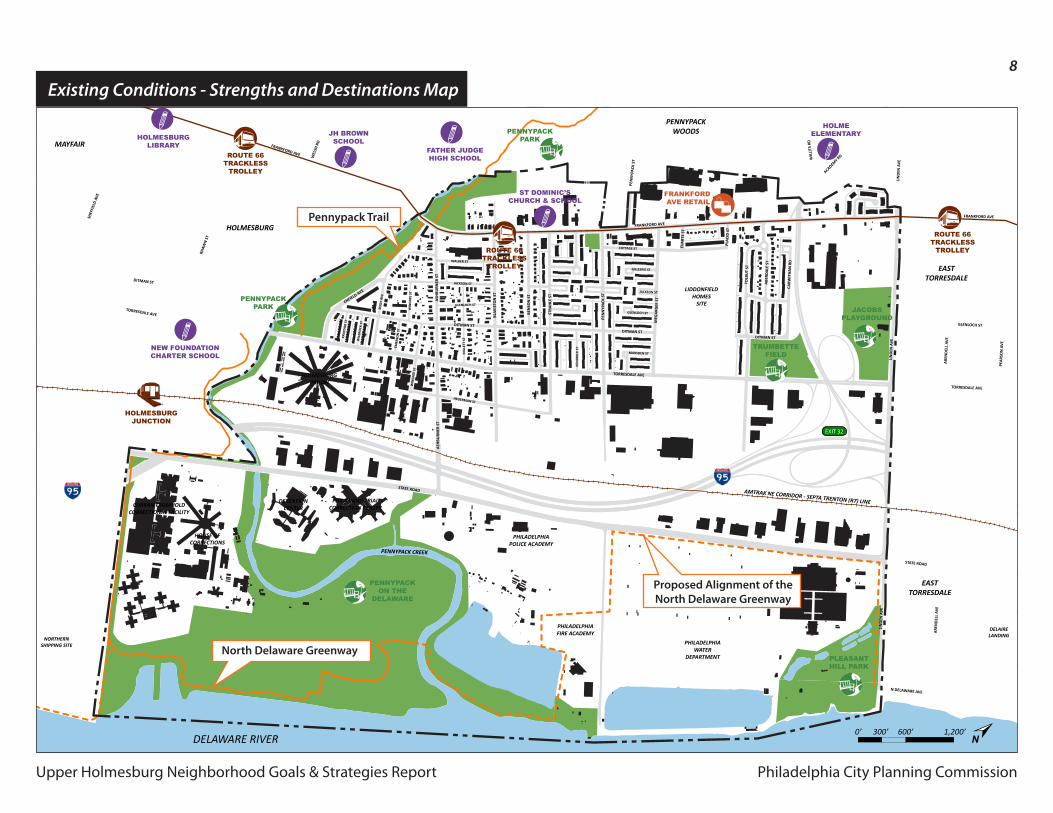
HOLMESBURGJUNCTION
HOLMEELEMENTARY
FRANKFORD AVE RETAIL
ROUTE 66 TRACKLESS
TROLLEY ROUTE 66 TRACKLESS
TROLLEY
ROUTE 66 TRACKLESS
TROLLEY
FATHER JUDGEHIGH SCHOOL
JH BROWNSCHOOLHOLMESBURG
LIBRARY
NEW FOUNDATIONCHARTER SCHOOL
ST DOMINIC’SCHURCH & SCHOOL
PLEASANTHILL PARK
TRUMBETTEFIELD
JACOBSPLAYGROUND
Existing Conditions - Strengths and Destinations Map
Pennypack Trail
Proposed Alignment of theNorth Delaware Greenway
North Delaware Greenway
Philadelphia City Planning Commission
9
Upper Holmesburg Neighborhood Goals & Strategies Report
+
+
Stre
ngth
s
-
-
Wea
knes
ses
i
i
Pote
ntia
l Im
prov
emen
tsExisting Conditions - Strengths & Destinations
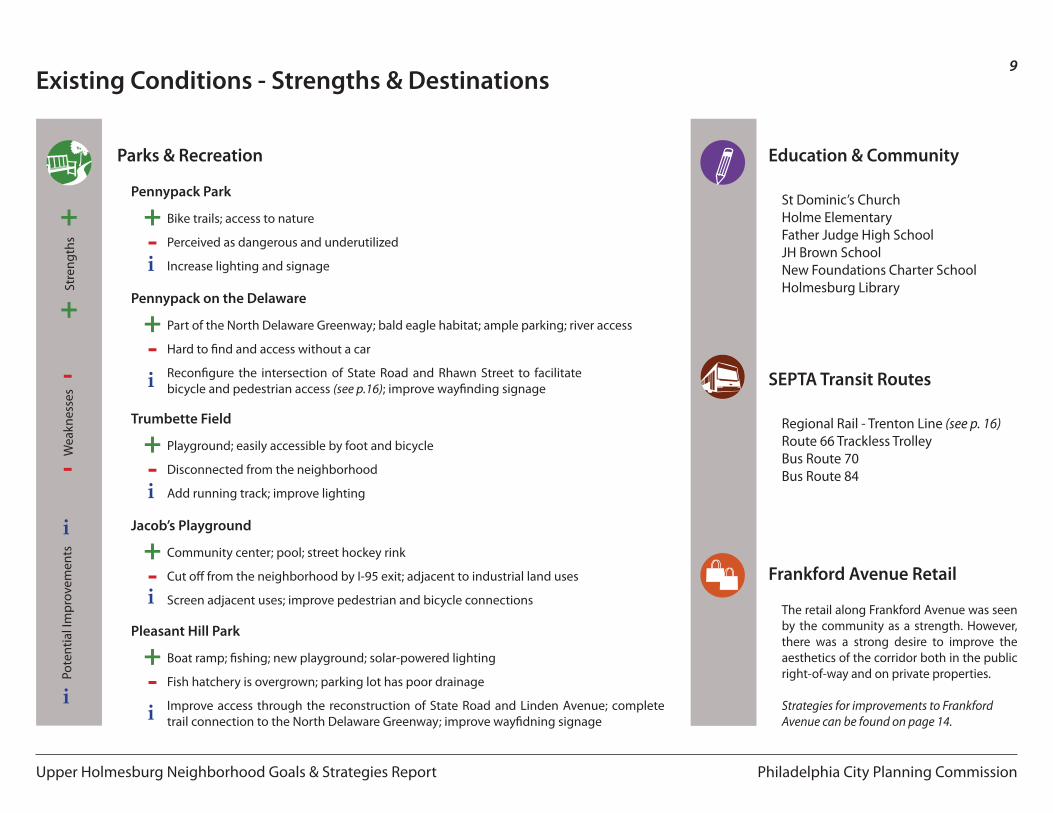
Parks & Recreation
i
+-
Bike trails; access to nature
Pennypack Park
Perceived as dangerous and underutilized
Increase lighting and signage
i
+-
Part of the North Delaware Greenway; bald eagle habitat; ample parking; river access
Pennypack on the Delaware
Hard to find and access without a car
Reconfigure the intersection of State Road and Rhawn Street to facilitate bicycle and pedestrian access (see p.16); improve wayfinding signage
i
+-
Playground; easily accessible by foot and bicycle
Trumbette Field
Disconnected from the neighborhood
Add running track; improve lighting
i
+-
Community center; pool; street hockey rink
Jacob’s Playground
Cut off from the neighborhood by I-95 exit; adjacent to industrial land uses
Screen adjacent uses; improve pedestrian and bicycle connections
i
+-
Boat ramp; fishing; new playground; solar-powered lighting
Pleasant Hill Park
Fish hatchery is overgrown; parking lot has poor drainage
Improve access through the reconstruction of State Road and Linden Avenue; complete trail connection to the North Delaware Greenway; improve wayfidning signage
Frankford Avenue Retail
Education & Community
St Dominic’s ChurchHolme ElementaryFather Judge High SchoolJH Brown SchoolNew Foundations Charter SchoolHolmesburg Library
SEPTA Transit Routes
Regional Rail - Trenton Line (see p. 16)Route 66 Trackless TrolleyBus Route 70Bus Route 84
The retail along Frankford Avenue was seen by the community as a strength. However, there was a strong desire to improve the aesthetics of the corridor both in the public right-of-way and on private properties.
Strategies for improvements to FrankfordAvenue can be found on page 14.
Philadelphia City Planning Commission
10
Upper Holmesburg Neighborhood Goals & Strategies Report
PlannedImprovements
ProposedStreetscape
Improvements
RedevelopmentProposals
Goals & Objectives
Neighborhood Goals:
1. Strengthen the character of Upper Holmesburg through coordinated, incremental improvements to the built environment.
2. Increase housing options, employment opportunities, and neighborhood connectivity through mixed-use, sustainable redevelopment of vacant and underutilized land.
3. Transform arterial streets into “complete streets” that safely accommodate automobile, transit, pedestrian, and bicycle users while contributing to the greening of the neighborhood.
4. Increase access to recreation opportunities afforded by Pennypack Park, the Delaware River waterfront, and other open spaces within and adjacent to the neighborhood.
5. Build upon and strengthen existing community groups and partnerships in order to promote neighborhood involvement, community building, and civic engagement.
Definition: Complete StreetsComplete Streets are designed to enable safe access for all users. Pedestrians, bicyclists, motorists, and transit riders of all ages and abilities must be able to safely move along and across a complete street. Complete streets make it easy to cross the street, walk to shops, and bicycle to work. They allow buses to run on time and make it easy for people to walk to and from transit stations.
Definition: Sustainable DevelopmentSustainable development is development that meets the needs of the present without compromising the ability of future generations to meet their own needs.
North Delaware GreenwayConnect people, businesses, and neighborhoods to the Delaware River through the transformation of the riverfront into a sustainable recreation corridor from Pulaski Park in Port Richmond to Glen Foerd in Torresdale.
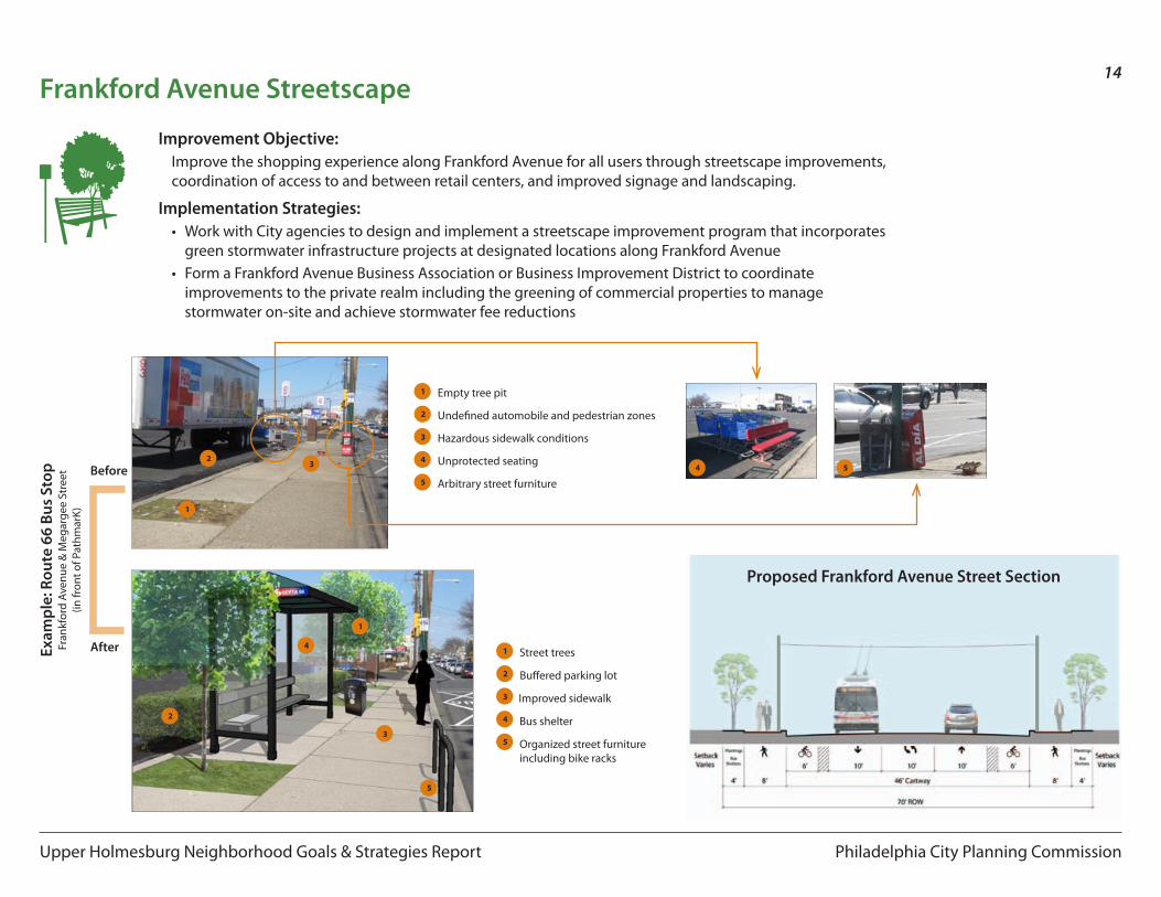
Frankford Avenue StreetscapeImprove the shopping experience along Frankford Avenue for all users through streetscape improvements, coordination of access to and between retail centers, and improved signage and landscaping.
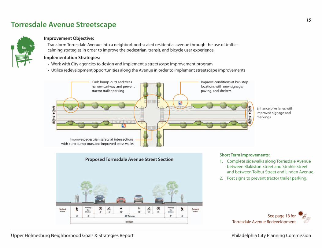
Torresdale Avenue StreetscapeTransform Torresdale Avenue into a neighborhood-scaled residential avenue through the use of traffic-calming strategies in order to improve the pedestrian, transit, and bicycle user experience.
Holmesburg Junction Train StationImprove Holmesburg Junction Train Station in order to increase usage for commuting into Center City.
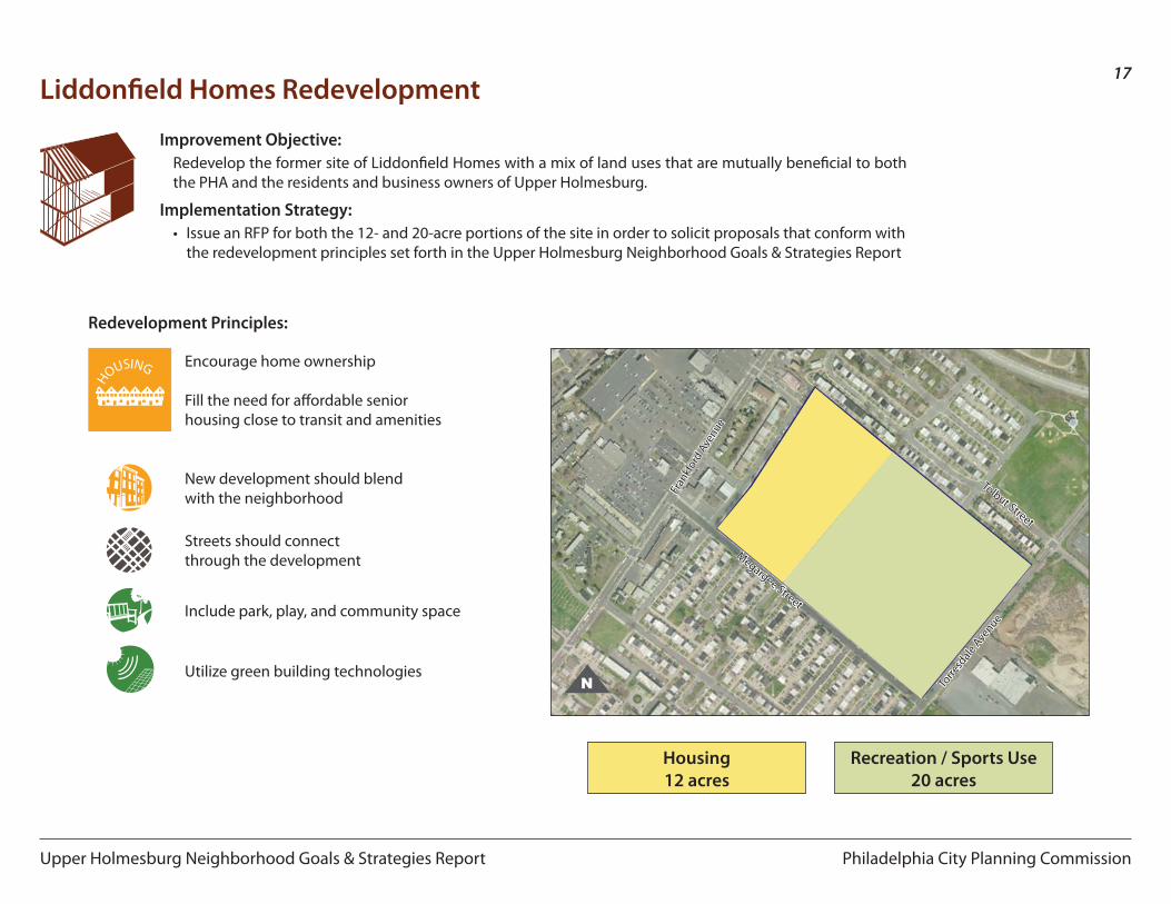
Liddonfield Homes RedevelopmentRedevelop the former site of Liddonfield Homes with a mix of land uses that are mutually beneficial to both the PHA and the residents and business owners of Upper Holmesburg.
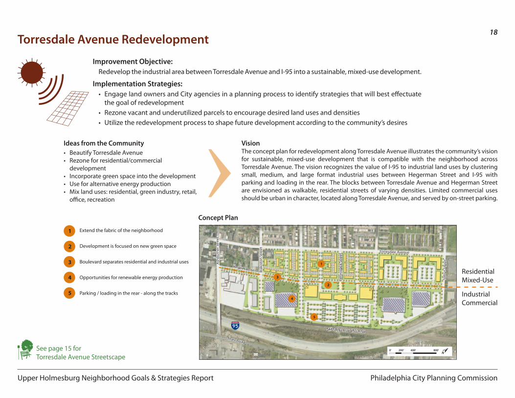
Torresdale Avenue RedevelopmentRedevelop the industrial area between Torresdale Avenue and I-95 into a sustainable, mixed-use development.
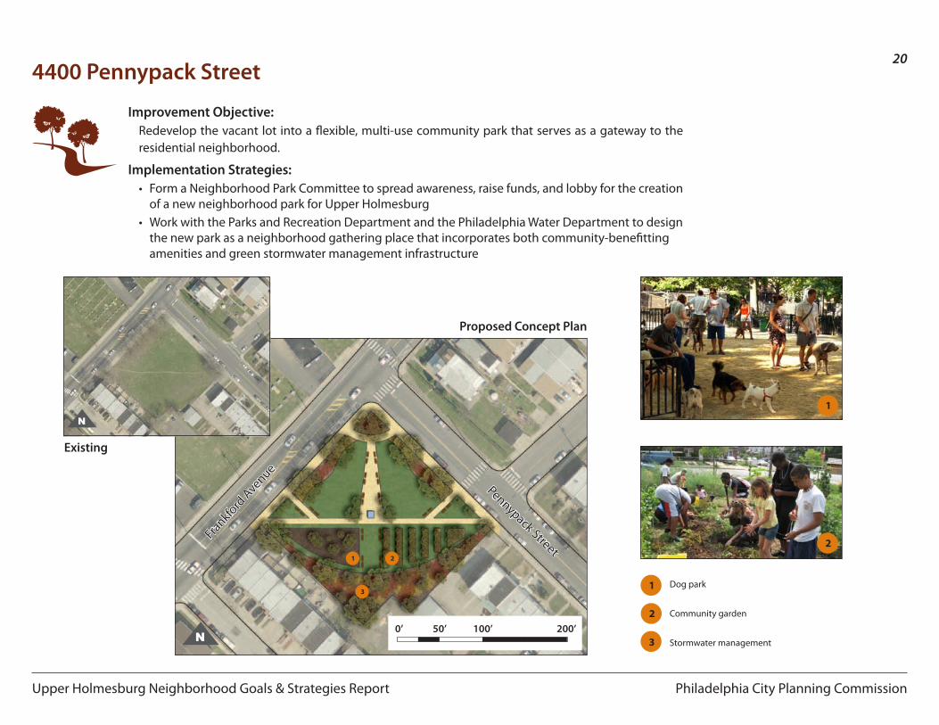
4400 Pennypack StreetRedevelop the vacant lot into a flexible, multi-use community park that serves as a gateway to the residential neighborhood.
Improvement Objectives:
Philadelphia City Planning Commission
11
Upper Holmesburg Neighborhood Goals & Strategies Report
PlannedImprovements
Proposed Streetscape
Improvements
Redevelopment Proposals
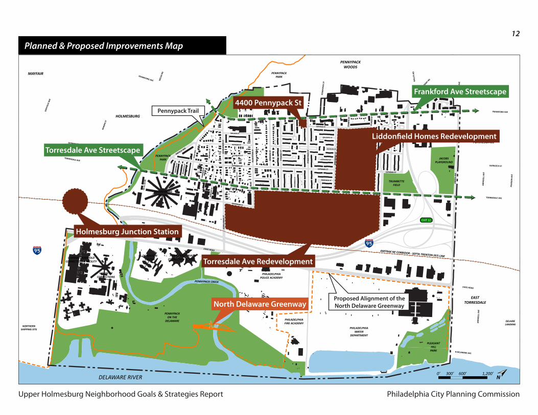
Planned & Proposed Improvements
p11Planned & Proposed Improvements Map
p12North Delaware Greenway
p15Holmesburg Junction Station
p13Frankford Avenue Streetscape
p14Torresdale Avenue Streetscape
p194400 Pennypack Street
p16Liddonfield Homes Redevelopment
p17Torresdale Avenue Redevelopment
Philadelphia City Planning CommissionUpper Holmesburg Neighborhood Goals & Strategies Report
12
Upper Holmesburg Neighborhood Goals & Strategies Report
March 17, 2011 Connections & Streetscape Improvements
Philadelphia CityPlanning Commission
Upper Holmesburg Civic Assoc.
FRANKFORD AVE
PEN
NYP
ACK
ST W
ILLI
TS R
D
FRANKFORD AVE
EVA
RTS
ST
PLA
CID
ST
TORRESDALE AVE
GLENLOCH ST
N DELAWARE AVE
TORRESDALE AVE
DITMAN ST
STATE ROAD
STATE ROAD
MEG
ARG
EE S
T
TOLB
UT
ST
ABE
RDA
LE S
T
CARW
ITH
AN
RD
DITMAN ST
ACADEMY R
D
LIN
DEN
AV
E
LIN
DEN
AV
E
PEA
RSO
N A
VE
ARE
ND
ELL
AVE
LIN
DEN
AV
E
ARE
ND
ELL
AVE
DITMAN ST
DITMAN ST
GLENLOCH ST
COTTAGE ST
MARSDEN ST
GILLESPIE ST
KEN
DRI
CK S
T
JACKSON ST
PEN
NYP
ACK
ST
STRA
HLE
ST
BEN
SON
ST
BLA
KIST
ON
ST
ASH
BURN
ER S
T
RHAW
N S
T
SHEF
FIEL
D A
VE
WEL
SH R
D
BLEI
GH
AV
E
WALKER ST
JACKSON ST
GLENLOCH ST
HEGERMAN ST
MIL
LETT
ST
WIN
GAT
E ST
WIL
BRO
CK S
T
KRAY
DO
R ST
WIN
GAT
E ST
EMER
SON
ST
SOLL
Y AV
E
ASH
BURN
ER S
T
ENFIELD AVE
AMTRAK NE CORRIDOR - SEPTA TRENTON (R7) LINE
PLEASANTHILLPARK
DELAIRELANDING
PENNYPACK CREEK
NORTHERNSHIPPING SITE
DELAWARE RIVER
HOLMESBURGPRISON
CURRAN FROMHOLDCORRECTIONAL FACILITY
HOUSE OFCORRECTIONS
DETENTIONCENTER
PHILA INDUSTRIALCORRECTION CENTER
PHILADELPHIAWATER
DEPARTMENT
PHILADELPHIAPOLICE ACADEMY
PHILADELPHIAFIRE ACADEMY
PENNYPACKON THE
DELAWARE
PENNYPACKPARK
PENNYPACKPARK
TRUMBETTEFIELD
JACOBSPLAYGROUND
EASTTORRESDALE
EASTTORRESDALE
PENNYPACKWOODS
HOLMESBURG
MAYFAIR
EXIT 32
0’ 300’ 600’ 1,200’N
North Delaware Greenway
Torresdale Ave Streetscape
Frankford Ave Streetscape
Liddonfield Homes Redevelopment
4400 Pennypack St
Torresdale Ave Redevelopment
Holmesburg Junction Station
Planned & Proposed Improvements Map
Pennypack Trail
Proposed Alignment of theNorth Delaware Greenway
Philadelphia City Planning Commission
13
Upper Holmesburg Neighborhood Goals & Strategies Report
on the internet www.drcc-phila.orgwww.greenway.org
North Delaware Greenway
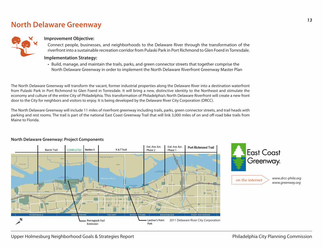
Improvement Objective:Connect people, businesses, and neighborhoods to the Delaware River through the transformation of the riverfront into a sustainable recreation corridor from Pulaski Park in Port Richmond to Glen Foerd in Torresdale.
Implementation Strategy:• Build, manage, and maintain the trails, parks, and green connector streets that together comprise the
North Delaware Greenway in order to implement the North Delaware Riverfront Greenway Master Plan
The North Delaware Greenway will transform the vacant, former industrial properties along the Delaware River into a destination waterfront from Pulaski Park in Port Richmond to Glen Foerd in Torresdale. It will bring a new, distinctive identity to the Northeast and stimulate the economy and culture of the entire City of Philadelphia. This transformation of Philadelphia’s North Delaware Riverfront will create a new front door to the City for neighbors and visitors to enjoy. It is being developed by the Delaware River City Corporation (DRCC).
The North Delaware Greenway will include 11 miles of riverfront greenway including trails, parks, green connector streets, and trail heads with parking and rest rooms. The trail is part of the national East Coast Greenway Trail that will link 3,000 miles of on and off-road bike trails from Maine to Florida.
North Delaware Greenway: Project Components
2011 Delaware River City Corporation
Philadelphia City Planning Commission
14
Upper Holmesburg Neighborhood Goals & Strategies Report
Frankford Avenue Streetscape
Improvement Objective:Improve the shopping experience along Frankford Avenue for all users through streetscape improvements, coordination of access to and between retail centers, and improved signage and landscaping.
Implementation Strategies:• Work with City agencies to design and implement a streetscape improvement program that incorporates
green stormwater infrastructure projects at designated locations along Frankford Avenue• Form a Frankford Avenue Business Association or Business Improvement District to coordinate
improvements to the private realm including the greening of commercial properties to manage stormwater on-site and achieve stormwater fee reductions
1
2
3
4
Empty tree pit
Hazardous sidewalk conditions
Unprotected seating
Undefined automobile and pedestrian zones
5 Arbitrary street furniture4 53
2
1
Exam
ple:
Rou
te 6
6 Bu
s St
op Before
AfterFran
kfor
d Av
enue
& M
egar
gee
Stre
et
(in fr
ont o
f Pat
hmar
K)
1
2
3
4
Street trees
Improved sidewalk
Bus shelter
Organized street furniture including bike racks
5
Buffered parking lot
3
2
1
4
5
Proposed Frankford Avenue Street Section
Philadelphia City Planning Commission
15
Upper Holmesburg Neighborhood Goals & Strategies Report
Torresdale Avenue Streetscape
Improvement Objective:Transform Torresdale Avenue into a neighborhood-scaled residential avenue through the use of traffic-calming strategies in order to improve the pedestrian, transit, and bicycle user experience.
Implementation Strategies:• Work with City agencies to design and implement a streetscape improvement program• Utilize redevelopment opportunities along the Avenue in order to implement streetscape improvements
Improve conditions at bus stop locations with new signage, paving, and shelters
Enhance bike lanes with improved signage and markings
Improve pedestrian safety at intersections with curb bump-outs and improved cross walks
Curb bump-outs and trees narrow cartway and prevent tractor trailer parking
Short Term Improvements:1. Complete sidewalks along Torresdale Avenue
between Blakiston Street and Strahle Street and between Tolbut Street and Linden Avenue.
2. Post signs to prevent tractor trailer parking.
Proposed Torresdale Avenue Street Section
See page 18 forTorresdale Avenue Redevelopment
Philadelphia City Planning Commission
16
Upper Holmesburg Neighborhood Goals & Strategies Report
North Delaware Riverfront Rail Stations Urban Design Study: BRIDESBURG . WISSINOMING . TACONY . HOLMESBURG JUNCTION . TORRESDALE Philadelphia City Planning Commission || Interface Studio LLc
160
North Delaware Riverfront Rail Stations Urban Design Study: BRIDESBURG . WISSINOMING . TACONY . HOLMESBURG JUNCTION . TORRESDALE Philadelphia City Planning Commission || Interface Studio LLc
H o l m e s b u g
J u n c t i o n
Potential development scenario illustrating four new buildings of varying height integrated with
extensions of Pennypack Park.
Expand the presence of the station
Expand Pennypack on the Delaware to State Rd
Reuse abandoned rail line for trail connection
Create new parking dedicated to train users
Slow traffic on Rhawn Street
Redevelopmentopportunity
on the internet
157
North Delaware Riverfront Rail Stations Urban Design Study: BRIDESBURG . WISSINOMING . TACONY . HOLMESBURG JUNCTION . TORRESDALE Philadelphia City Planning Commission || Interface Studio LLc North Delaware Riverfront Rail Stations Urban Design Study: BRIDESBURG . WISSINOMING . TACONY . HOLMESBURG JUNCTION . TORRESDALE Philadelphia City Planning Commission || Interface Studio LLc
the western frontage of State Road should also be considered for new landscaping and an expanded sidewalk to accomodate pedestrians and bicyclists. This trail extension should be coordinated with the Fairmount Park Commission.
• Create an entrance to Pennypack Park on the Delaware with new pedestrian crossings, a distinctive sign, bicycle path and mounded planting beds.
• Enhance the streetscape from Rhawn Street to State Road and Rhawn Street to the riverfront for pedestrians and bicyclists with a distinctive:
o Planting of street trees; o Street lights;o Sidewalk paving pattern;o Bicycle lane; ando Directional signage.
Reconnect the Station to Pennypack Park and the RiverfrontThe primary opportunity for making this linkage is to improve the State Road and Rhawn Street intersection. The intent is to more strongly bring the presence of the Pennypack on the Delaware Park to State Road with a pronounced entrance while ensuring the existing trail of Pennypack Park is seamlessly linked to this resource. The improvements to this area must address both design and traffic calming.
Design Improvements:• Create a new entrance to Pennypack Park on the northwest corner of Rhawn
and State Road.• Connect the entrances to Pennypack Park and Pennypack Park on the
Delaware with a pedestrian and bicycle path within the triangular plaza on the eastern side of State Road. The edge of an existing parking lot along
Top: The existing Rhawn Street and State Road intersection.Bottom: Potential improvements.
Top: Street view of the existing entrance to Pennypack on the Delaware Park.Bottom: Potential improvements.
North Delaware Riverfront Rail Stations Urban Design Study: BRIDESBURG . WISSINOMING . TACONY . HOLMESBURG JUNCTION . TORRESDALE Philadelphia City Planning Commission || Interface Studio LLc
158
North Delaware Riverfront Rail Stations Urban Design Study: BRIDESBURG . WISSINOMING . TACONY . HOLMESBURG JUNCTION . TORRESDALE Philadelphia City Planning Commission || Interface Studio LLc
H o l m
e s b u g
J u n c t i o n
• Ensure that the Northern Shipping site is using Rhawn Street as their access road to State Road and not creating a separate entrance road.
• Create new bulb-outs and crosswalks at this intersection to facilitate pedestrian crossings.
Slow Rhawn Street During non-peak periods (with respect to station use), Rhawn Street invites high traffic speeds due to its wide cross section (including the little-used parking lane during these periods). As a result, it is worthwhile to consider adding an intermittent ‘permanent element’, such as tree plantings, to the parking lane in order to preserve a sense of narrowness and buffer in both the peak and the non-peak periods. This would achieve the following:
• Help to restrict traffic speeds by presenting a permanent narrow profile to drivers.
• Prevent cars from traveling in the parking lane (i.e. as in order to pass slower cars).
• Minimize impact on parking capacity, with a narrow tree planting between every three to four spaces.
• Green and beautify the corridor.• Delineate Rhawen Street as a bicycle corridor. The travel lanes should be
marked as shared lanes to encourage more bicycle ridership.• Coordinate with the Philadelphia Water Department to address any continuing
stormwater management issues.
Traffic Calming:• Create a bulb-out on the southeast corner of Rhawn Street and State Road
to slow turning movements and decrease pedestrian crossing distances.• Create a bulb-out on the northwest corner along Rhawn Street to slow turning
traffic.• Integrate bollards or other vertical edge treatments along State Road to add
a sense of improved comfort to the pedestrian ‘wait-to-cross’ areas.• Create a new traffic light at the intersection of State Road and Rhawn Street
where the entrance to the Pennypack on the Delaware Park is located. This lighted intersection will likely be necessary with the redevelopment of the Northern Shipping site.
Top Left: Rhawn Street due to limited, active building frontages and street plantings carries fast-moving traffic. Top Right: An example of tree plantings and bulb-outs within parking lanes in Conshohocken. Bottom Left: Existing layout of Rhawn Stre� c.
Improvement Objective:Improve Holmesburg Junction Train Station in order to increase usage for commuting into Center City.
Implementation Strategies:• Improve the function and aesthetics of the station through increased parking dedicated to commuters
and landscaping and infrastructure improvements• Encourage the redevelopment of adjacent parcels in order to increase density around the station • Employ traffic calming measures on Rhawn Street from Torresdale Avenue to State Road
Holmesburg Junction Station
1
2
3
3
4
4
5
6
1
6
5
4
3
2
www.philaplanning.org/plans/ndelrailfull.pdf
Existing Layout of Rhawn Street
Top: The existing intersection of Rhawn Street and State RoadBottom: Potential improvements
Station Area plan for Holmesburg Junction
Proposed Layout of Rhawn Street
Top: Street view of existing entrance to Pennypack on the DelawareBottom: Potential improvements
Philadelphia City Planning Commission
17
Upper Holmesburg Neighborhood Goals & Strategies Report
Improvement Objective:Redevelop the former site of Liddonfield Homes with a mix of land uses that are mutually beneficial to both the PHA and the residents and business owners of Upper Holmesburg.
Implementation Strategy:• Issue an RFP for both the 12- and 20-acre portions of the site in order to solicit proposals that conform with
the redevelopment principles set forth in the Upper Holmesburg Neighborhood Goals & Strategies Report
Liddonfield Homes Redevelopment
Streets should connect through the development
Include park, play, and community space
Utilize green building technologies
New development should blend with the neighborhood
Encourage home ownership
Fill the need for affordable senior housing close to transit and amenities
Housing12 acres
Recreation / Sports Use20 acres
Torre
sdale
Ave
nue
Tolbut Street
Megargee Street
Fran
kfor
d Ave
nue
Redevelopment Principles:
N
Philadelphia City Planning Commission
18
Upper Holmesburg Neighborhood Goals & Strategies Report
‹See page 15 forTorresdale Avenue Streetscape
1
2
3
4
Extend the fabric of the neighborhood
Boulevard separates residential and industrial uses
Opportunities for renewable energy production
Parking / loading in the rear - along the tracks5
Development is focused on new green space
ResidentialMixed-Use
IndustrialCommercial
Torresdale Avenue Redevelopment
Improvement Objective:Redevelop the industrial area between Torresdale Avenue and I-95 into a sustainable, mixed-use development.
Implementation Strategies:• Engage land owners and City agencies in a planning process to identify strategies that will best effectuate
the goal of redevelopment• Rezone vacant and underutilized parcels to encourage desired land uses and densities• Utilize the redevelopment process to shape future development according to the community’s desires
VisionThe concept plan for redevelopment along Torresdale Avenue illustrates the community’s vision for sustainable, mixed-use development that is compatible with the neighborhood across Torresdale Avenue. The vision recognizes the value of I-95 to industrial land uses by clustering small, medium, and large format industrial uses between Hegerman Street and I-95 with parking and loading in the rear. The blocks between Torresdale Avenue and Hegerman Street are envisioned as walkable, residential streets of varying densities. Limited commercial uses should be urban in character, located along Torresdale Avenue, and served by on-street parking.
1
2
3
4
5
Ideas from the Community• Beautify Torresdale Avenue• Rezone for residential/commercial
development• Incorporate green space into the development• Use for alternative energy production• Mix land uses: residential, green industry, retail,
office, recreation
0’ 200’ 400’ 800’N
Torresdale Avenue
State Road
Hegerman St
Tolb
ut S
tree
t
Penn
ypac
k St
reet
Blak
isto
n St
reet
Ash
burn
er S
tree
t
SEPTA Trenton (R7) LINE
Concept Plan
Philadelphia City Planning CommissionUpper Holmesburg Neighborhood Goals & Strategies Report
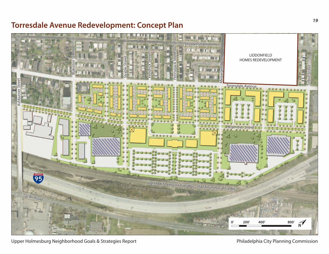
19Torresdale Avenue Redevelopment: Concept Plan
Torresdale Avenue
State Road
Hegerman Street
AMTRAK Northeast Corridor - SEPTA Trenton (R7) LINE
Ditman Street
Meg
arge
e St
reet
Tolb
ut S
tree
t
Penn
ypac
k St
reet
Kend
rick
Stre
et
Stra
hle
Stre
et
Blak
isto
n St
reet
Ash
burn
er S
tree
t
0’ 200’ 400’ 800’N
LIDDONFIELDHOMES REDEVELOPMENT
Philadelphia City Planning Commission
20
Upper Holmesburg Neighborhood Goals & Strategies Report
0’ 50’ 100’ 200’
Improvement Objective:Redevelop the vacant lot into a flexible, multi-use community park that serves as a gateway to the residential neighborhood.
Implementation Strategies:• Form a Neighborhood Park Committee to spread awareness, raise funds, and lobby for the creation
of a new neighborhood park for Upper Holmesburg• Work with the Parks and Recreation Department and the Philadelphia Water Department to design
the new park as a neighborhood gathering place that incorporates both community-benefitting amenities and green stormwater management infrastructure
4400 Pennypack Street
1
1
2
2
3
Dog park
Stormwater management
Community garden
N
N
1 2
3
Existing
Proposed Concept Plan
Frankfo
rd Avenue
Pennypack Street
Philadelphia City Planning Commission
21
Upper Holmesburg Neighborhood Goals & Strategies Report
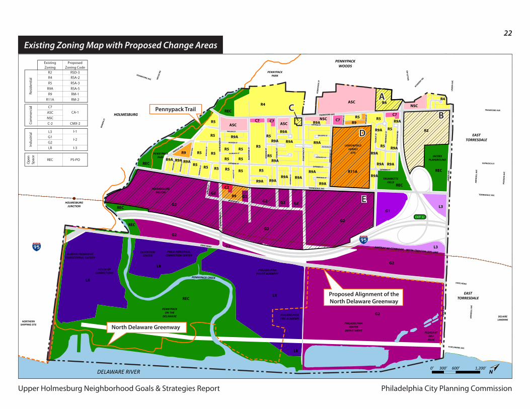
Zoning Recommendations
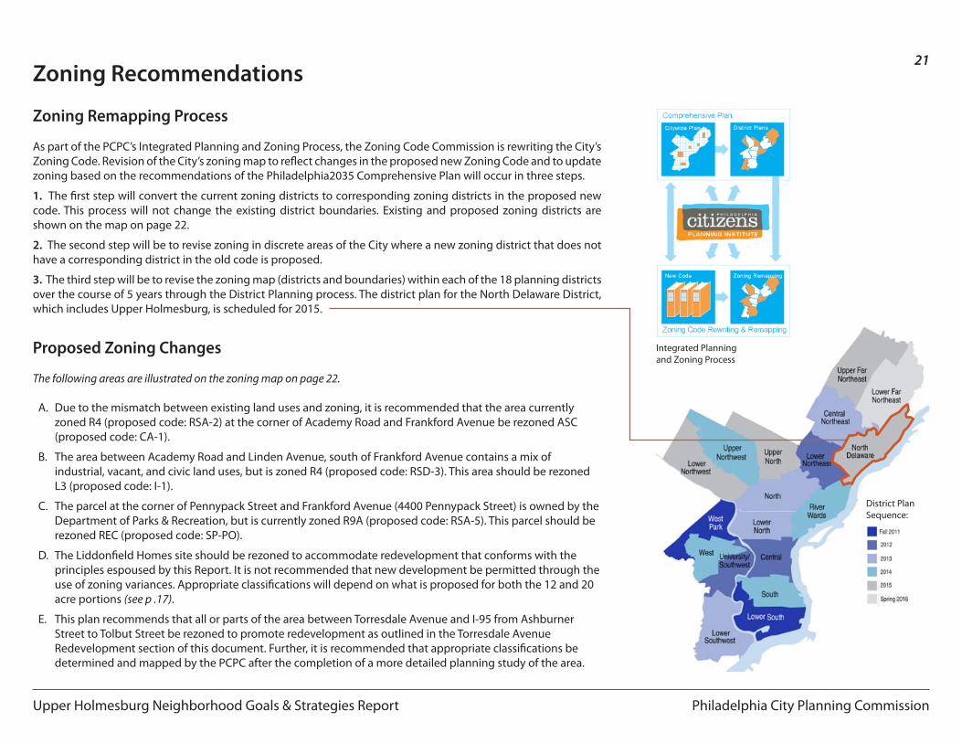
Zoning Remapping Process
As part of the PCPC’s Integrated Planning and Zoning Process, the Zoning Code Commission is rewriting the City’s Zoning Code. Revision of the City’s zoning map to reflect changes in the proposed new Zoning Code and to update zoning based on the recommendations of the Philadelphia2035 Comprehensive Plan will occur in three steps.
1. The first step will convert the current zoning districts to corresponding zoning districts in the proposed new code. This process will not change the existing district boundaries. Existing and proposed zoning districts are shown on the map on page 22.
2. The second step will be to revise zoning in discrete areas of the City where a new zoning district that does not have a corresponding district in the old code is proposed.
3. The third step will be to revise the zoning map (districts and boundaries) within each of the 18 planning districts over the course of 5 years through the District Planning process. The district plan for the North Delaware District, which includes Upper Holmesburg, is scheduled for 2015.
Proposed Zoning Changes
The following areas are illustrated on the zoning map on page 22.
A. Due to the mismatch between existing land uses and zoning, it is recommended that the area currently zoned R4 (proposed code: RSA-2) at the corner of Academy Road and Frankford Avenue be rezoned ASC (proposed code: CA-1).
B. The area between Academy Road and Linden Avenue, south of Frankford Avenue contains a mix of industrial, vacant, and civic land uses, but is zoned R4 (proposed code: RSD-3). This area should be rezoned L3 (proposed code: I-1).
C. The parcel at the corner of Pennypack Street and Frankford Avenue (4400 Pennypack Street) is owned by the Department of Parks & Recreation, but is currently zoned R9A (proposed code: RSA-5). This parcel should be rezoned REC (proposed code: SP-PO).
D. The Liddonfield Homes site should be rezoned to accommodate redevelopment that conforms with the principles espoused by this Report. It is not recommended that new development be permitted through the use of zoning variances. Appropriate classifications will depend on what is proposed for both the 12 and 20 acre portions (see p .17).
E. This plan recommends that all or parts of the area between Torresdale Avenue and I-95 from Ashburner Street to Tolbut Street be rezoned to promote redevelopment as outlined in the Torresdale Avenue Redevelopment section of this document. Further, it is recommended that appropriate classifications be determined and mapped by the PCPC after the completion of a more detailed planning study of the area.
District Plan Sequence:
Integrated Planning and Zoning Process
Philadelphia City Planning CommissionUpper Holmesburg Neighborhood Goals & Strategies Report
22
Upper Holmesburg Neighborhood Goals & Strategies Report
February 17, 2011 Existing Zoning
Philadelphia CityPlanning Commission
Upper Holmesburg Civic Assoc.
FRANKFORD AVE
FRANKFORD AVE
PEN
NYP
ACK
ST W
ILLI
TS R
D
FRANKFORD AVE
EVA
RTS
ST
PLA
CID
ST
TORRESDALE AVE
TORRESDALE AVE
GLENLOCH ST
N DELAWARE AVE
TORRESDALE AVE
DITMAN ST
STATE ROAD
STATE ROAD
MEG
ARG
EE S
T
TOLB
UT
ST
ABE
RDA
LE S
T
CARW
ITH
AN
RD
DITMAN ST
ACADEMY R
D
LIN
DEN
AV
E
LIN
DEN
AV
E
PEA
RSO
N A
VE
ARE
ND
ELL
AVE
LIN
DEN
AV
E
ARE
ND
ELL
AVE
DITMAN ST
DITMAN ST
GLENLOCH ST
COTTAGE ST
MARSDEN ST
GILLESPIE ST
KEN
DRI
CK S
T
JACKSON ST
PEN
NYP
ACK
ST
STRA
HLE
ST
BEN
SON
ST
BLA
KIST
ON
ST
ASH
BURN
ER S
T
RHAW
N S
T
SHEF
FIEL
D A
VE
WEL
SH R
D
BLEI
GH
AV
E
WALKER ST
JACKSON ST
GLENLOCH ST
HEGERMAN ST
MIL
LETT
ST
WIN
GAT
E ST
WIL
BRO
CK S
T
KRAY
DO
R ST
WIN
GAT
E ST
EMER
SON
ST
SOLL
Y AV
E
ASH
BURN
ER S
T
ENFIELD AVE
AMTRAK NE CORRIDOR - SEPTA TRENTON (R7) LINE
PLEASANTHILLPARK
DELAIRELANDING
PENNYPACK CREEK
NORTHERNSHIPPING SITE
DELAWARE RIVER
HOLMESBURGPRISON
CURRAN FROMHOLDCORRECTIONAL FACILITY
HOUSE OFCORRECTIONS
DETENTIONCENTER
PHILA INDUSTRIALCORRECTION CENTER
PHILADELPHIAWATER
DEPARTMENT
PHILADELPHIAPOLICE ACADEMY
PHILADELPHIAFIRE ACADEMY
LIDDONFIELDHOMES
SITE
PENNYPACKON THE
DELAWARE
PENNYPACKPARK
PENNYPACKPARK
TRUMBETTEFIELD
JACOBSPLAYGROUND
HOLMESBURGJUNCTION
EASTTORRESDALE
EASTTORRESDALE
PENNYPACKWOODS
HOLMESBURG
MAYFAIR
EXIT 32
G2
G2
G2
G2
G1
REC
REC
REC
REC
REC
REC
REC
L3G2G2G2
G2R9
C2G2
R11A
R9A
R9A
R9A
R9A
R9AR9A
R9AR9A
R9A R9A R9A
R9
R9AR9A
R9A
R9AR9A
R5
R5
R5
R5
R5R5R5R5R5
R5 R5
R5
R5
R5 R5
R5R5
R9AR9A
R9A
R9A
R9AR9R5R5
R4R4
R2
R4
NSC
NSC
ASC
ASCASCC7
C7
C7C7
R9A
R9A
R5
R5
LR
L3
LR
LR
G2
G2
LR
G2
0’ 300’ 600’ 1,200’N
Existing Zoning Map with Proposed Change Areas
CA-1
I-2
Com
mer
cial
Existing Zoning
Proposed Zoning Code
R2 RSD-3R4 RSA-2R5 RSA-3
R9A RSA-5R9 RM-1
R11A RM-2
C7ASCNSCC-2 CMX-2
L3 I-1G1G2LR I-3
Ope
n Sp
ace
REC PS-PO
Resi
dent
ial
Indu
stria
l
E
B
D
ACPennypack Trail
Proposed Alignment of theNorth Delaware Greenway
North Delaware Greenway
Philadelphia City Planning Commission
23
Upper Holmesburg Neighborhood Goals & Strategies Report
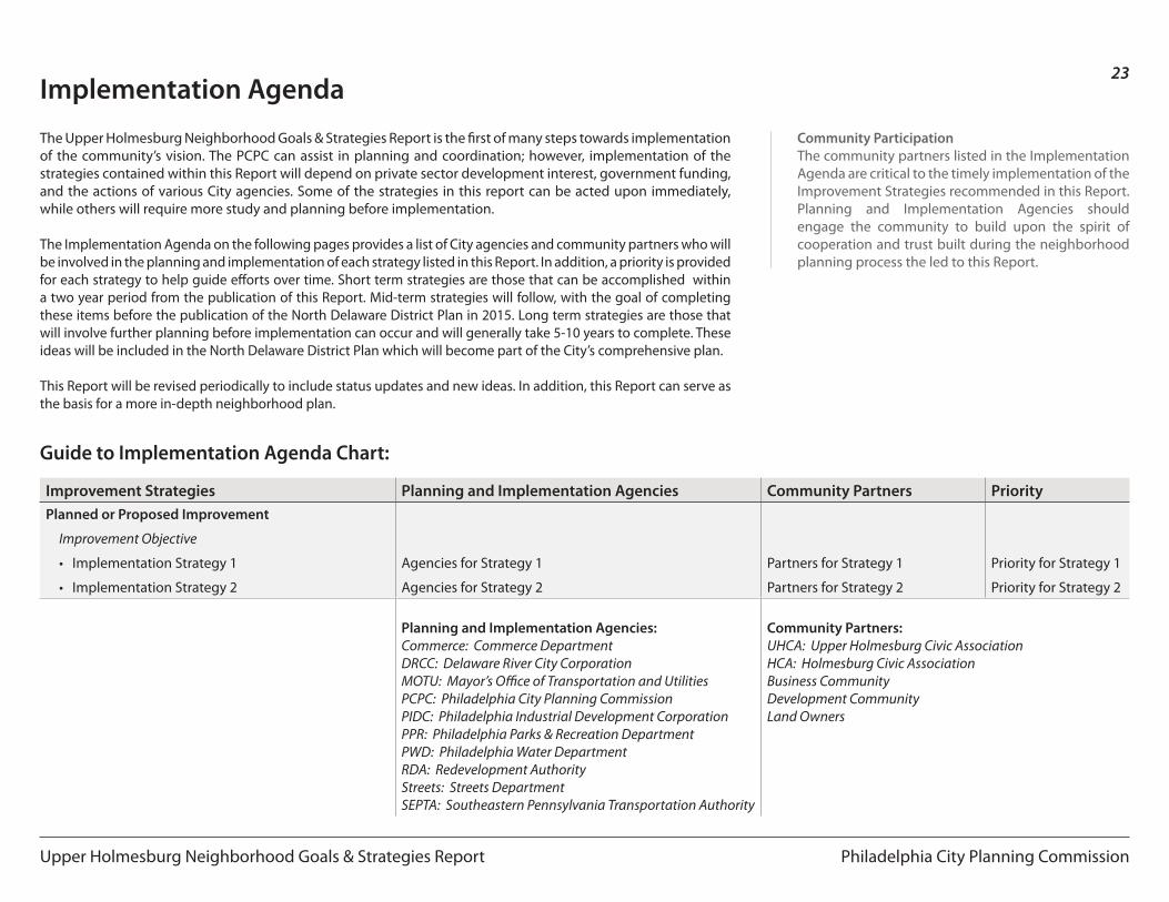
Implementation Agenda
The Upper Holmesburg Neighborhood Goals & Strategies Report is the first of many steps towards implementation of the community’s vision. The PCPC can assist in planning and coordination; however, implementation of the strategies contained within this Report will depend on private sector development interest, government funding, and the actions of various City agencies. Some of the strategies in this report can be acted upon immediately, while others will require more study and planning before implementation.
The Implementation Agenda on the following pages provides a list of City agencies and community partners who will be involved in the planning and implementation of each strategy listed in this Report. In addition, a priority is provided for each strategy to help guide efforts over time. Short term strategies are those that can be accomplished within a two year period from the publication of this Report. Mid-term strategies will follow, with the goal of completing these items before the publication of the North Delaware District Plan in 2015. Long term strategies are those that will involve further planning before implementation can occur and will generally take 5-10 years to complete. These ideas will be included in the North Delaware District Plan which will become part of the City’s comprehensive plan.
This Report will be revised periodically to include status updates and new ideas. In addition, this Report can serve as the basis for a more in-depth neighborhood plan.
Improvement Strategies Planning and Implementation Agencies Community Partners PriorityPlanned or Proposed Improvement
Improvement Objective
• Implementation Strategy 1
• Implementation Strategy 2
Agencies for Strategy 1
Agencies for Strategy 2
Partners for Strategy 1
Partners for Strategy 2
Priority for Strategy 1
Priority for Strategy 2
Planning and Implementation Agencies:Commerce: Commerce DepartmentDRCC: Delaware River City CorporationMOTU: Mayor’s Office of Transportation and UtilitiesPCPC: Philadelphia City Planning CommissionPIDC: Philadelphia Industrial Development CorporationPPR: Philadelphia Parks & Recreation DepartmentPWD: Philadelphia Water DepartmentRDA: Redevelopment AuthorityStreets: Streets DepartmentSEPTA: Southeastern Pennsylvania Transportation Authority
Community Partners:UHCA: Upper Holmesburg Civic AssociationHCA: Holmesburg Civic AssociationBusiness CommunityDevelopment CommunityLand Owners
Guide to Implementation Agenda Chart:
Community ParticipationThe community partners listed in the Implementation Agenda are critical to the timely implementation of the Improvement Strategies recommended in this Report. Planning and Implementation Agencies should engage the community to build upon the spirit of cooperation and trust built during the neighborhood planning process the led to this Report.
Philadelphia City Planning Commission
24
Upper Holmesburg Neighborhood Goals & Strategies Report
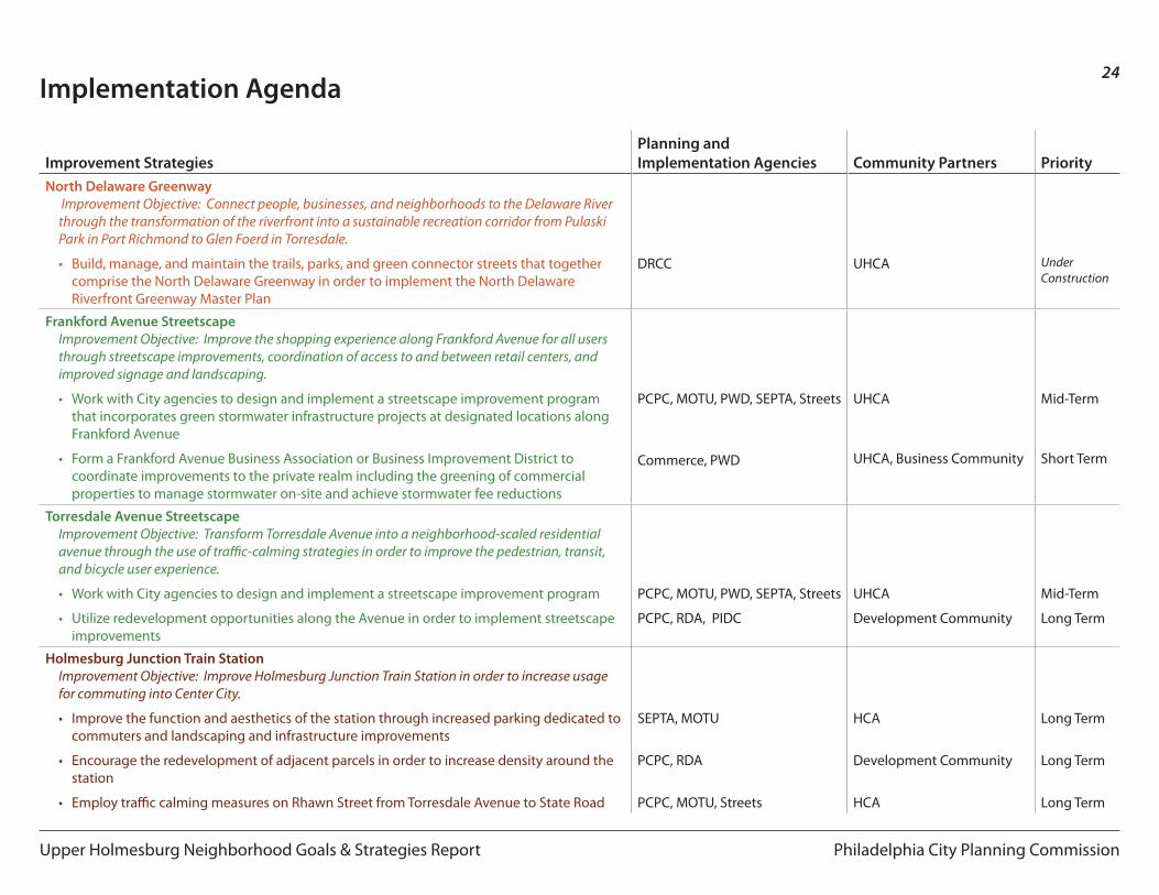
Implementation Agenda
Improvement StrategiesPlanning and Implementation Agencies Community Partners Priority
North Delaware Greenway Improvement Objective: Connect people, businesses, and neighborhoods to the Delaware River through the transformation of the riverfront into a sustainable recreation corridor from Pulaski Park in Port Richmond to Glen Foerd in Torresdale.
• Build, manage, and maintain the trails, parks, and green connector streets that together comprise the North Delaware Greenway in order to implement the North Delaware Riverfront Greenway Master Plan
DRCC UHCA Under Construction
Frankford Avenue StreetscapeImprovement Objective: Improve the shopping experience along Frankford Avenue for all users through streetscape improvements, coordination of access to and between retail centers, and improved signage and landscaping.
• Work with City agencies to design and implement a streetscape improvement program that incorporates green stormwater infrastructure projects at designated locations along Frankford Avenue
• Form a Frankford Avenue Business Association or Business Improvement District to coordinate improvements to the private realm including the greening of commercial properties to manage stormwater on-site and achieve stormwater fee reductions
PCPC, MOTU, PWD, SEPTA, Streets
Commerce, PWD
UHCA
UHCA, Business Community
Mid-Term
Short Term
Torresdale Avenue StreetscapeImprovement Objective: Transform Torresdale Avenue into a neighborhood-scaled residential avenue through the use of traffic-calming strategies in order to improve the pedestrian, transit, and bicycle user experience.
• Work with City agencies to design and implement a streetscape improvement program
• Utilize redevelopment opportunities along the Avenue in order to implement streetscape improvements
PCPC, MOTU, PWD, SEPTA, Streets
PCPC, RDA, PIDC
UHCA
Development Community
Mid-Term
Long Term
Holmesburg Junction Train StationImprovement Objective: Improve Holmesburg Junction Train Station in order to increase usage for commuting into Center City.
• Improve the function and aesthetics of the station through increased parking dedicated to commuters and landscaping and infrastructure improvements
• Encourage the redevelopment of adjacent parcels in order to increase density around the station
• Employ traffic calming measures on Rhawn Street from Torresdale Avenue to State Road
SEPTA, MOTU
PCPC, RDA
PCPC, MOTU, Streets
HCA
Development Community
HCA
Long Term
Long Term
Long Term
Philadelphia City Planning Commission
25
Upper Holmesburg Neighborhood Goals & Strategies Report
Implementation Agenda
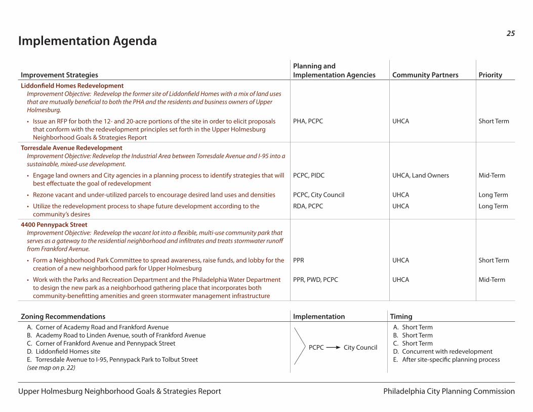
Improvement StrategiesPlanning and Implementation Agencies Community Partners Priority
Liddonfield Homes RedevelopmentImprovement Objective: Redevelop the former site of Liddonfield Homes with a mix of land uses that are mutually beneficial to both the PHA and the residents and business owners of Upper Holmesburg.
• Issue an RFP for both the 12- and 20-acre portions of the site in order to elicit proposals that conform with the redevelopment principles set forth in the Upper Holmesburg Neighborhood Goals & Strategies Report
PHA, PCPC UHCA Short Term
Torresdale Avenue RedevelopmentImprovement Objective: Redevelop the Industrial Area between Torresdale Avenue and I-95 into a sustainable, mixed-use development.
• Engage land owners and City agencies in a planning process to identify strategies that will best effectuate the goal of redevelopment
• Rezone vacant and under-utilized parcels to encourage desired land uses and densities
• Utilize the redevelopment process to shape future development according to the community’s desires
PCPC, PIDC
PCPC, City Council
RDA, PCPC
UHCA, Land Owners
UHCA
UHCA
Mid-Term
Long Term
Long Term
4400 Pennypack StreetImprovement Objective: Redevelop the vacant lot into a flexible, multi-use community park that serves as a gateway to the residential neighborhood and infiltrates and treats stormwater runoff from Frankford Avenue.
• Form a Neighborhood Park Committee to spread awareness, raise funds, and lobby for the creation of a new neighborhood park for Upper Holmesburg
• Work with the Parks and Recreation Department and the Philadelphia Water Department to design the new park as a neighborhood gathering place that incorporates both community-benefitting amenities and green stormwater management infrastructure
PPR
PPR, PWD, PCPC
UHCA
UHCA
Short Term
Mid-Term
Zoning Recommendations Implementation TimingA. Corner of Academy Road and Frankford Avenue B. Academy Road to Linden Avenue, south of Frankford AvenueC. Corner of Frankford Avenue and Pennypack StreetD. Liddonfield Homes siteE. Torresdale Avenue to I-95, Pennypack Park to Tolbut Street (see map on p. 22)
PCPC City Council
A. Short TermB. Short TermC. Short TermD. Concurrent with redevelopment E. After site-specific planning process
Philadelphia City Planning Commission
26
Upper Holmesburg Neighborhood Goals & Strategies Report
aCknowledgemenTs
Planning Team
Stan Cywinski, President - UHCABob Hall, Vice President - UHCANancy Quinn, Secretary - UHCABobbie Gunning, Treasurer - UHCAPaul DefinisLynne GregoryPaul GonsiewskiPaul KauffmanMarion ChristensenMartin BednarekSandy Stewart
PCPC Project Staff
Gary J. Jastrzab, Executive DirectorRichard Redding, Director - Community Planning Division
Ian Litwin, Project ManagerLaura M. Spina, Senior PlannerC. Beige Berryman, Urban Designer
Collaborators
Michael Johns, Philadelphia Housing AuthorityJessica Noon, Philadelphia Water Department David Perri, Streets Department Sarah Low, Parks and Recreation DepartmentSandi King, Commerce DepartmentThomas J. Branigan, Delaware River City Corporation