Embed Size (px)
Citation preview

NEOLITHIC IRELAND AND BRITAIN (Part 1)
By Mike McPhee [Text of an address to the Sydney Unitarian Church on 21 February 2021.] When I chose this title, all that ‘Neolithic’ meant to me was the New Stone Age – and all I knew about that was that it was a period when the most advanced stone tools were developed and when the megalithic structures you’ll be seeing today were constructed. However, it turns out that there is much more to the Stone Ages – just looking at Europe, they were: 1. the Paleolithic Era (Old Stone Age) from 1.6 million years ago to 15,000 years ago 2. the Mesolithic Era from 15,000 to 5000 years ago; and 3. the Neolithic Era from 7000 to 1700 BCE (The dates are necessarily approximate and there is some overlap because the progression moved more rapidly in Southern Europe than in Northern Europe.} It will be clear from the dates that the Paleolithic Era began before modern humans evolved. This should not surprise us, as it is known that our precursors, such as Homo erectus and Homo heidelbergensis used tools made from stone, wood and bone. However, the earliest stone tools were fairly simple, consisting of core tools and the flakes that were broken off them. Similarly, the first wooden tools, such as spears, were merely shaped with stone hand-axes or knives:
It should be added that the end of the Paleolithic Era corresponds to the final phases of the Pleistocene Ice Age, which lasted from 2.6 Mya to 11,700 BP. Over that time, the quality of stone tools progressively improved and the first artwork emerged in the forms of figurines and cave paintings. Modern humans arrived in Europe from Africa about 50,000 years ago to find it already occupied by the Neanderthals, who had evolved there.

The Mesolithic Era, while brief, marked major advances in both technology and lifestyle. In Europe, the end
of the Ice Age and the extinction of megafauna such as mammoths caused a shift in hunting practices and a
broader approach to gathering. Most notably, we see the development of more sophisticated and typically
smaller stone tools and weapons with wooden or bone handles. (A burin is a tool with a narrow sharp face at
the tip used for engraving and other fine cutting.)
It was during this time that pottery and textiles were developed in certain regions, as well as the beginning of
agriculture. Primitive dwellings were built before that time and those were greatly improved with the use of
more advanced tools. The more permanent settlements tended to be close to the sea or inland waters, offering
a good supply of food. (This is to say that not all people were nomadic at this time.) Mesolithic societies are
not seen as having been very complex and burials were fairly simple, though primitive cemeteries from that
period have been found. Instead of cave paintings, there was rock art on cliff faces that depicted clothed
people dancing, fighting, hunting and food-gathering.
Understandably, the Mesolithic technology moved from south to north over time, as a combined function of migration and cultural exchange. The same progression was even more dramatic in what is aptly called the Neolithic Revolution, which transformed human society forever. By 10,000 BCE, the domestication of animals and plants had reached an advanced stage in Mesopotamia (also Egypt, India and China), from where it spread to the Levant and Anatolia, also resulting in larger and more permanent settlements than ever before. A people known only as the Early European Farmers moved in from Anatolia, eventually overwhelming the indigenous hunger-gatherers in numbers. As the map shows, they progressed westward and northward at an average rate of one kilometre per year for the next 5000 years.
These pre-Indo-European people brought with them yet more sophisticated stone tools – to the point of polished axes – pottery and artwork. Those axes were used to clear large areas of land for farming, though much of that deforestation was accomplished through ringbarking and burning. The cultivation of cereal grains also required the development of grinding tools, which were also used to crush nuts and other vegetable products. The new abundance of food resulted in a population explosion across most of Europe.
So, finally we can look at Britain and Ireland, though I must first explain that both islands were heavily
glaciated during the Ice Age. Any traces of previous habitation in Ireland would have been pulverised under
ice sheets 3 km thick, though there is little reason to think anyone got there before the Mesolithic Era. In the
south of Britain, pre-human fossils have been found dating back to 900,000 years ago. Modern humans arrived
40,000 years ago but, even as the ice sheet was receding, the climate in Britain and Ireland was that of arctic
tundra – therefore, their occupations were brief and intermittent.
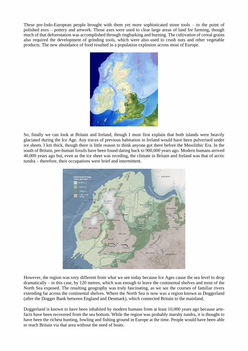
However, the region was very different from what we see today because Ice Ages cause the sea level to drop
dramatically – in this case, by 120 metres, which was enough to leave the continental shelves and most of the
North Sea exposed. The resulting geography was truly fascinating, as we see the courses of familiar rivers
extending far across the continental shelves. Where the North Sea is now was a region known as Doggerland
(after the Dogger Bank between England and Denmark), which connected Britain to the mainland.
Doggerland is known to have been inhabited by modern humans from at least 10,000 years ago because arte-
facts have been recovered from the sea bottom. While the region was probably marshy tundra, it is thought to
have been the richest hunting, fowling and fishing ground in Europe at the time. People would have been able
to reach Britain via that area without the need of boats.
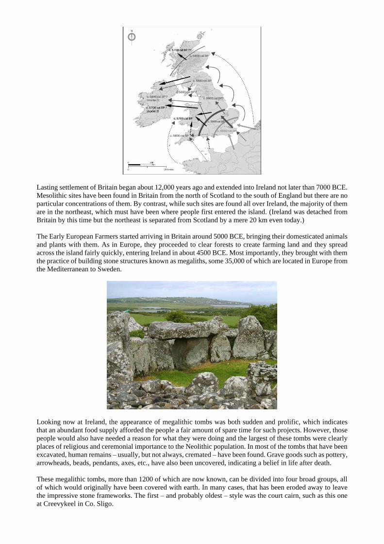
Lasting settlement of Britain began about 12,000 years ago and extended into Ireland not later than 7000 BCE.
Mesolithic sites have been found in Britain from the north of Scotland to the south of England but there are no
particular concentrations of them. By contrast, while such sites are found all over Ireland, the majority of them
are in the northeast, which must have been where people first entered the island. (Ireland was detached from
Britain by this time but the northeast is separated from Scotland by a mere 20 km even today.)
The Early European Farmers started arriving in Britain around 5000 BCE, bringing their domesticated animals
and plants with them. As in Europe, they proceeded to clear forests to create farming land and they spread
across the island fairly quickly, entering Ireland in about 4500 BCE. Most importantly, they brought with them
the practice of building stone structures known as megaliths, some 35,000 of which are located in Europe from
the Mediterranean to Sweden.
Looking now at Ireland, the appearance of megalithic tombs was both sudden and prolific, which indicates
that an abundant food supply afforded the people a fair amount of spare time for such projects. However, those
people would also have needed a reason for what they were doing and the largest of these tombs were clearly
places of religious and ceremonial importance to the Neolithic population. In most of the tombs that have been
excavated, human remains – usually, but not always, cremated – have been found. Grave goods such as pottery,
arrowheads, beads, pendants, axes, etc., have also been uncovered, indicating a belief in life after death.
These megalithic tombs, more than 1200 of which are now known, can be divided into four broad groups, all
of which would originally have been covered with earth. In many cases, that has been eroded away to leave
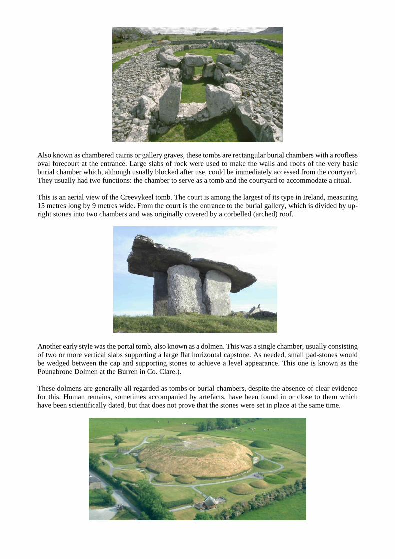
the impressive stone frameworks. The first – and probably oldest – style was the court cairn, such as this one
at Creevykeel in Co. Sligo.
Also known as chambered cairns or gallery graves, these tombs are rectangular burial chambers with a roofless
oval forecourt at the entrance. Large slabs of rock were used to make the walls and roofs of the very basic
burial chamber which, although usually blocked after use, could be immediately accessed from the courtyard.
They usually had two functions: the chamber to serve as a tomb and the courtyard to accommodate a ritual.
This is an aerial view of the Creevykeel tomb. The court is among the largest of its type in Ireland, measuring
15 metres long by 9 metres wide. From the court is the entrance to the burial gallery, which is divided by up-
right stones into two chambers and was originally covered by a corbelled (arched) roof.
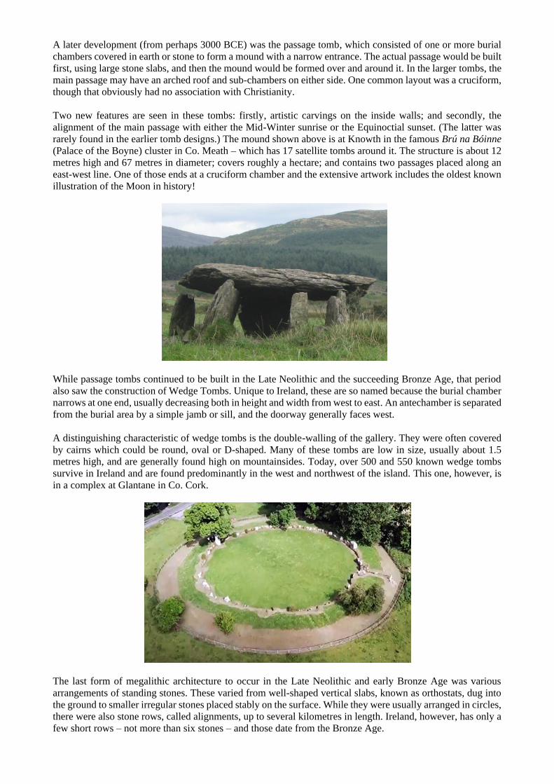
Another early style was the portal tomb, also known as a dolmen. This was a single chamber, usually consisting
of two or more vertical slabs supporting a large flat horizontal capstone. As needed, small pad-stones would
be wedged between the cap and supporting stones to achieve a level appearance. This one is known as the
Pounabrone Dolmen at the Burren in Co. Clare.).
These dolmens are generally all regarded as tombs or burial chambers, despite the absence of clear evidence
for this. Human remains, sometimes accompanied by artefacts, have been found in or close to them which
have been scientifically dated, but that does not prove that the stones were set in place at the same time.
A later development (from perhaps 3000 BCE) was the passage tomb, which consisted of one or more burial
chambers covered in earth or stone to form a mound with a narrow entrance. The actual passage would be built
first, using large stone slabs, and then the mound would be formed over and around it. In the larger tombs, the
main passage may have an arched roof and sub-chambers on either side. One common layout was a cruciform,
though that obviously had no association with Christianity.
Two new features are seen in these tombs: firstly, artistic carvings on the inside walls; and secondly, the
alignment of the main passage with either the Mid-Winter sunrise or the Equinoctial sunset. (The latter was
rarely found in the earlier tomb designs.) The mound shown above is at Knowth in the famous Brú na Bóinne
(Palace of the Boyne) cluster in Co. Meath – which has 17 satellite tombs around it. The structure is about 12
metres high and 67 metres in diameter; covers roughly a hectare; and contains two passages placed along an
east-west line. One of those ends at a cruciform chamber and the extensive artwork includes the oldest known
illustration of the Moon in history!
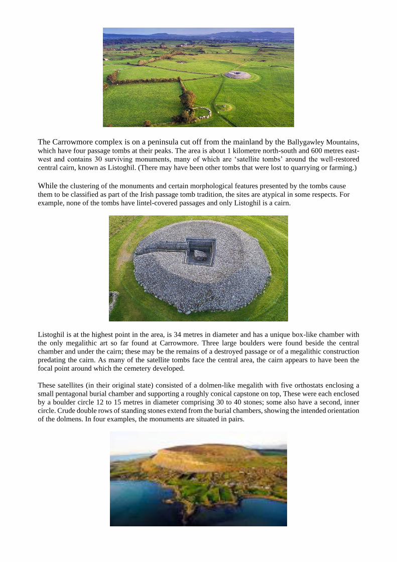
While passage tombs continued to be built in the Late Neolithic and the succeeding Bronze Age, that period
also saw the construction of Wedge Tombs. Unique to Ireland, these are so named because the burial chamber
narrows at one end, usually decreasing both in height and width from west to east. An antechamber is separated
from the burial area by a simple jamb or sill, and the doorway generally faces west.
A distinguishing characteristic of wedge tombs is the double-walling of the gallery. They were often covered
by cairns which could be round, oval or D-shaped. Many of these tombs are low in size, usually about 1.5
metres high, and are generally found high on mountainsides. Today, over 500 and 550 known wedge tombs
survive in Ireland and are found predominantly in the west and northwest of the island. This one, however, is
in a complex at Glantane in Co. Cork.
The last form of megalithic architecture to occur in the Late Neolithic and early Bronze Age was various
arrangements of standing stones. These varied from well-shaped vertical slabs, known as orthostats, dug into
the ground to smaller irregular stones placed stably on the surface. While they were usually arranged in circles,
there were also stone rows, called alignments, up to several kilometres in length. Ireland, however, has only a
few short rows – not more than six stones – and those date from the Bronze Age.

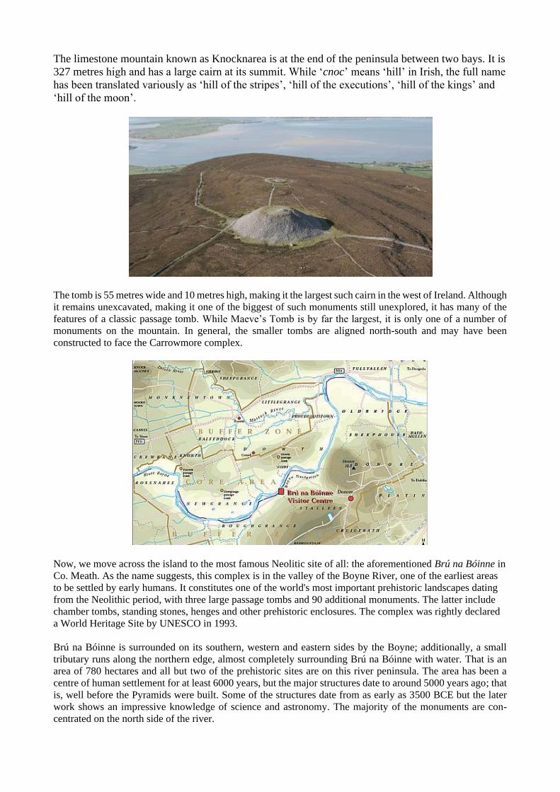
Most of the stone circles in Ireland are of a class called ‘axial’, meaning that the height of the stones decreases
in both directions from one end of the circle to the opposite side. The two tallest stones are called ‘portals’
because they form an entrance to the circle. Most of the Irish circles are in the southwest but this one is at
Lough Gur in Co. Limerick – known as Lios na Gráinsí (Fort of the Grange), it is one of eleven such circles
in the area and the second largest in Ireland. The circle is 45 metres in diameter with its entrance facing the
Mid-Summer sunrise; it consists of 113 standing stones – the most of any circle in the British Isles. The largest
stone is 4 metres high and weighs 40 tonnes; its foundation hole is 1.2 metres deep. There can be no doubt that
these circles were used for ritual purposes, though archeologists have little idea what those rituals were like.
So, after this overview, we can now look at three major megalithic complexes in Ireland, some of which have
only contemporaneous works but others were built over longer periods. The Carrowkeel cluster in Co. Sligo
consists of 14 court cairns in its central area and another 12 within a 6 kilometre radius. This is a hilly region
known as the Bricklieve Mountains and the larger tombs are on hilltops, as are some of the outlying tombs.
The Creevykeel structure we saw before is further south than that but the same river flows through the two
areas, so there is probably some connection.
One of the largest and highest of these tombs is just called Cairn G. It is considered a classic example
of an Irish passage tomb, consisting of a short passage leading to a central chamber with three equally
spaced side chambers. The walls are composed of eight well-matched orthostats and the chamber has
a superb corbelled ceiling; the floor was originally composed of limestone flagstones but is now
covered with cairn rubble. The most interesting feature of this tomb is the window-box situated above
the entrance, one of only two known in Ireland, aligned to the Mid-Summer sunset.
Two other cairns have their passages oriented northwest in the direction of a flat-topped mountain
called Knocknarea, 20 km away. That mountain dominates the older Carrowmore complex and is
topped by a large cairn known as Miosgán Meadhbha (Queen Maeve’s Tomb). That refers to a legendary
queen of Connacht in Gaelic mythology and the whole area is said to be the location of the yet-more-mythical
Battles of Moytura.
The Carrowmore complex is on a peninsula cut off from the mainland by the Ballygawley Mountains,
which have four passage tombs at their peaks. The area is about 1 kilometre north-south and 600 metres east-
west and contains 30 surviving monuments, many of which are ‘satellite tombs’ around the well-restored
central cairn, known as Listoghil. (There may have been other tombs that were lost to quarrying or farming.)
While the clustering of the monuments and certain morphological features presented by the tombs cause
them to be classified as part of the Irish passage tomb tradition, the sites are atypical in some respects. For
example, none of the tombs have lintel-covered passages and only Listoghil is a cairn.
Listoghil is at the highest point in the area, is 34 metres in diameter and has a unique box-like chamber with
the only megalithic art so far found at Carrowmore. Three large boulders were found beside the central
chamber and under the cairn; these may be the remains of a destroyed passage or of a megalithic construction
predating the cairn. As many of the satellite tombs face the central area, the cairn appears to have been the
focal point around which the cemetery developed.
These satellites (in their original state) consisted of a dolmen-like megalith with five orthostats enclosing a
small pentagonal burial chamber and supporting a roughly conical capstone on top, These were each enclosed
by a boulder circle 12 to 15 metres in diameter comprising 30 to 40 stones; some also have a second, inner
circle. Crude double rows of standing stones extend from the burial chambers, showing the intended orientation
of the dolmens. In four examples, the monuments are situated in pairs.
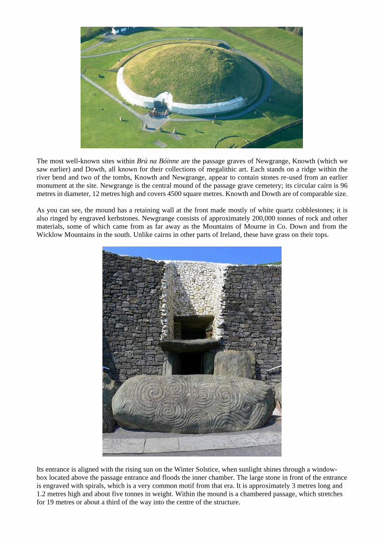
The limestone mountain known as Knocknarea is at the end of the peninsula between two bays. It is
327 metres high and has a large cairn at its summit. While ‘cnoc’ means ‘hill’ in Irish, the full name
has been translated variously as ‘hill of the stripes’, ‘hill of the executions’, ‘hill of the kings’ and
‘hill of the moon’.
The tomb is 55 metres wide and 10 metres high, making it the largest such cairn in the west of Ireland. Although
it remains unexcavated, making it one of the biggest of such monuments still unexplored, it has many of the
features of a classic passage tomb. While Maeve’s Tomb is by far the largest, it is only one of a number of
monuments on the mountain. In general, the smaller tombs are aligned north-south and may have been
constructed to face the Carrowmore complex.
Now, we move across the island to the most famous Neolitic site of all: the aforementioned Brú na Bóinne in
Co. Meath. As the name suggests, this complex is in the valley of the Boyne River, one of the earliest areas
to be settled by early humans. It constitutes one of the world's most important prehistoric landscapes dating
from the Neolithic period, with three large passage tombs and 90 additional monuments. The latter include
chamber tombs, standing stones, henges and other prehistoric enclosures. The complex was rightly declared
a World Heritage Site by UNESCO in 1993.
Brú na Bóinne is surrounded on its southern, western and eastern sides by the Boyne; additionally, a small
tributary runs along the northern edge, almost completely surrounding Brú na Bóinne with water. That is an
area of 780 hectares and all but two of the prehistoric sites are on this river peninsula. The area has been a
centre of human settlement for at least 6000 years, but the major structures date to around 5000 years ago; that
is, well before the Pyramids were built. Some of the structures date from as early as 3500 BCE but the later
work shows an impressive knowledge of science and astronomy. The majority of the monuments are con-
centrated on the north side of the river.
The most well-known sites within Brú na Bóinne are the passage graves of Newgrange, Knowth (which we
saw earlier) and Dowth, all known for their collections of megalithic art. Each stands on a ridge within the
river bend and two of the tombs, Knowth and Newgrange, appear to contain stones re-used from an earlier
monument at the site. Newgrange is the central mound of the passage grave cemetery; its circular cairn is 96
metres in diameter, 12 metres high and covers 4500 square metres. Knowth and Dowth are of comparable size.
As you can see, the mound has a retaining wall at the front made mostly of white quartz cobblestones; it is
also ringed by engraved kerbstones. Newgrange consists of approximately 200,000 tonnes of rock and other
materials, some of which came from as far away as the Mountains of Mourne in Co. Down and from the
Wicklow Mountains in the south. Unlike cairns in other parts of Ireland, these have grass on their tops.
Its entrance is aligned with the rising sun on the Winter Solstice, when sunlight shines through a window-
box located above the passage entrance and floods the inner chamber. The large stone in front of the entrance
is engraved with spirals, which is a very common motif from that era. It is approximately 3 metres long and
1.2 metres high and about five tonnes in weight. Within the mound is a chambered passage, which stretches
for 19 metres or about a third of the way into the centre of the structure.

At the end of the passage are three small chambers off a larger central chamber with a high corbelled vault
roof. Each of the smaller chambers has a large flat ‘basin stone’ where the bones of the dead may have been
deposited – whether it was a burial site remains unclear. The walls of this passage are made up of large
orthostats that average 1.5 metres in height; several of which are decorated with carvings. It is believed that
the carvings were done before the slabs were put in place.
We only have time to quickly look at a couple of other features in the complex (which I wasn’t able to find
out any more about). This is what is known as a portal tomb, though I don’t think the circular openings around
the sides were originally there.
And this is the Sacred Well, about which I have found absolutely nothing, despite my efforts However, it is
truly beautiful and must have had some significance to the people who built it,
And that will have to do for now – we’ll look at structures in Britain next time.


![VIP Escapes Great Britain & Ireland [Chinese Version]](https://img.pdfslide.net/doc/110x75/568cad101a28ab186daa1e04/vip-escapes-great-britain-ireland-chinese-version.jpg)