Embed Size (px)
Citation preview

65
Active Tectonics and Seismic Potential of AlaskaGeophysical Monograph Series 179Copyright 2008 by the American Geophysical Union.10.1029/179GM04
Neotectonics of the Yakutat Collision: Changes in Deformation Driven by Mass Redistribution
James B. Chapman,1 Terry L. Pavlis,1 Sean Gulick,2 Aaron Berger,3 Lindsay Lowe,2 James Spotila,3 Ronald Bruhn,4 Michael Vorkink,4 Peter Koons,5 Adam Barker,5 Carlos Picornell,6 Ken Ridgway,7
Bernard Hallet,8 John Jaeger,9 and James McCalpin10
The most recent period of orogenesis in southern Alaska began in the late Neogene with the collision of the Yakutat microplate, which is partially accreted to and partially subducted beneath the Alaskan margin at the easternmost extent of the Aleutian Trench. Neotectonic studies suggest significant spatial and kinematic variation in active deformation during the collision of the Yakutat microplate. The Saint Elias orogen experienced a widespread structural reorganization in the Quaternary with oblique convergence partitioned onto an en echelon thrust array. The new tectonic configuration also includes the continuing development of an incipient indentor corner, significant retrothrust motion, and shifting deformation fronts. Reorganization is temporally linked to intense glacial erosion in the core of orogen and rapid sedimentation in offshore depocenters during the Pleistocene. We propose that mass redistribution and modification of orogenic topography played an integral role in the structural and tectonic evolution of the present system. Currently, the spatial deformation front (outboard limit of deformation) and active deformation front are not the same, suggesting that deformation swept through the landscape through time, presumably as a result of glaciation, tectonic adjustment, or both. A more complete picture of the complex response of nearsurface deformation to topographic disruption should improve seismic hazard assessments.
1Department of Geological Sciences, University of Texas at El Paso, El Paso, Texas, USA.
2Institute for Geophysics, Jackson School of Geosciences, University of Texas at Austin, Austin, Texas, USA.
3Department of Geosciences, Virginia Polytechnic Institute and State University, Blacksburg, Virginia, USA.
4Department of Geology and Geophysics, University of Utah, Salt Lake City, Utah, USA.
5Department of Geological Sciences, University of Maine, Orono, Maine, USA.
6Chevron USA, New Orleans, Louisiana, USA.7Department of Earth Sciences, Purdue University, West Lafay
ette, Indiana, USA.8Department of Earth and Space Sciences, University of Wash
ington, Seattle, Washington, USA.9Department of Geological Sciences, University of Florida,
Gainesville, Florida, USA.10GEOHAZ Consulting, Crestone, Colorado, USA.

66 NEOTECTONICS OF THE YAKUTAT COLLISION
1. INTRODUCTION
Southern Alaska is a complex assemblage of accreted terranes and accretionary complexes of which the Yakutat microplate is the latest addition [Plafker et al., 1994]. The Yakutat microplate was excised from the Cordilleran margin during the early Tertiary and transported northward along marginparallel transform faults, including the Fairweather fault [Plafker et al., 1978; Bruns, 1983; Plafker et al., 1994] (Figure 1). As transport continued, the microplate encountered the continental margin at the Aleutian Trench where the ongoing collision with southern Alaska fundamentally reshaped the northern Cordillera, produced North America’s highest mountain range, and the highest coastal mountain range on Earth. The collision is currently driving orogenesis throughout the region and may be responsible for far-field deformation deep into the Cordilleran interior [Mazzotti and Hynd-man, 2002]. As such, any consideration of neotectonics and seismicity in the northern Cordillera cannot ignore the role of the Yakutat collision. However, a poor understanding of the current distribution of deformation within the Yakutat microplate limits the development of successful tectonic models. Recent work as part of the Saint Elias Erosion and tectonics Project (STEEP) is helping to resolve the location of active structures and exploring the role of erosion in the spatiotemporal evolution of deformation within the Yakutat collision.
In this work, we present a review of the Yakutat microplate collision and architecture of the Saint Elias orogen with a focus on areas considered candidates for active deformation. Key points of this chapter include evidence for structural reorganization in the Quaternary and the potential effects of erosion on strain localization within the orogen. Specifically, widespread mass redistribution as a result of intense glacial excavation in the Pleistocene may have altered the way in which deformation is partitioned in response to oblique convergence.
2. REGIONAL TECTONICS
The Yakutat microplate is readily distinguished from the adjacent Mesozoic and early Cenozoic accretionary complex by a diagnostic Tertiary sedimentary sequence that thins to the east across a composite basement assemblage (Figure 1). To the west, Yakutat microplate basement is inferred to be a Paleogene oceanic assemblage [Plafker, 1987], probably an oceanic plateau [Wells et al., 1984], that is now subducted hundreds of kilometers beneath southern Alaska [Eberhart-Phillips et al., 2006]. To the east, Yakutat basement consists of “continentalized,” metamorphosed flysch and accretionary mélange of a late Mesozoic subduction complex that is partially accreted to the North American margin [Plafker,
1987; Bruhn et al., 2004]. The two basement types are separated by a highangle structural boundary referred to as the Dangerous River Zone [Plafker, 1987; Plafker et al., 1994], which is overlapped offshore by Tertiary strata, but may be a major structural factor for partitioning deformation in the core of the orogen. Overlying this composite basement is a thick sedimentary cover sequence including ~4 km of Paleogene shallow marine to fluvial strata unconformably overlain by up to 5 km of syntectonic glaciomarine strata of the Yakataga formation [Plafker, 1987; Eyles and Lagoe, 1990]. The onset of glaciation and deposition of the Yakataga formation is coincident with the beginning of mountain building in the late Miocene [Eyles et al., 1991].
After a period of middle Cenozoic marginparallel transport on the Pacific–North American transform boundary, the Yakutat microplate arrived at the Aleutian Trench and initiated orogenesis in the midtolate Miocene [e.g., Plafker et al., 1994]. A variety of processes related to the Yakutat collision constructed the present high topography in southern Alaska. First, the indentation of the North American margin by the Yakutat microplate is driving the reactivation of structures well inboard of the collision including the Denali fault system [Stout and Chase, 1980; Lahr and Plafker, 1980]. Also, outside the immediate collision zone, underthrusting of the buoyant Yakutat oceanic basement led to flat slab subduction, which appears to be causing regional uplift of much of southern Alaska [e.g., Pavlis et al., 2004; Eberhart-Phillips, 2006]. On the periphery of the collision, volcanism, previously interpreted as a normal arc complex [Nye, 1983; Richter et al., 1994], assembled the Wrangell Mountains, although recent work suggests that magmatism is related to slabmelt associated with plateedge effects [Preece and Hart, 2004]. Models for Wrangell volcanism not linked to arc systems are consistent with a poorly defined deep seismic zone [Page, 1989; Eberhart-Phillips et al., 2006]. Finally, the Yakutat microplate is driving proximal orogenesis in the Fairweather, Saint Elias, and eastern Chugach mountain ranges with basementinvolved transpressional systems in the hinterland and a thinskinned foldandthrust belt in the foreland [Bruhn et al., 2004; Pavlis et al., 2004]. This oblique convergence zone can be loosely described as a threedimensional orogenic wedge [Koons, 1994] whose character changes along strike as a result of the transition from strikeslip motion to subduction. The transition is manifested as a complex tectonic corner with multiple possible deformation fronts with differing structural styles.
3. DEFORMATION FRONTS
The Yakutat microplate can be structurally divided into the western, central, and eastern segments as defined by Bruhn et

CHAPMAN ET AL. 67
Figu
re 1
. Ove
rvie
w m
ap o
f the
Yak
utat
mic
ropl
ate a
nd su
rrou
ndin
g ge
olog
y af
ter P
lafk
er [1
987]
. Not
e the
loca
tion
of cr
oss s
ectio
n A
–A¢ a
cros
s the
fold
-and
-thru
st b
elt p
rese
nted
in F
igur
e 3
and
sect
ion
B–B
¢ acr
oss t
he P
ampl
ona
zone
pre
sent
ed in
Fig
ure
5. C
SEF,
C
huga
ch S
aint
Elia
s Fau
lt (s
utur
e). V
eloc
ity v
ecto
rs fr
om F
letc
her a
nd F
reym
uelle
r [20
03].

68 NEOTECTONICS OF THE YAKUTAT COLLISION
al. [2004] (Figure 1). The eastern segment is internally undeformed, but bounded to the east by the Fairweather fault and associated transpressive structures that locally comprise the suture between the Yakutat microplate and North America. The central segment is separated from the eastern segment by the Pamplona zone offshore and its onshore equivalent, the Malaspina fault, which form the outboard limit to foldandthrust deformation typical of the central segment (Figure 1). The Chugach Saint Elias fault (CSEF) is the suture for the central segment, although the mechanical backstop for the orogen occurs to the north of the suture along the Bagley Ice Field [Berger et al., 2008]. Deformational style becomes more complex west of the Bering Glacier in the western segment, where the original foldandthrust belt of the central segment appears to be complexly refolded [Bruhn et al., 2004; Pavlis et al., 2004]. Deformation may be more diffuse in the western segment, but is at least partially concentrated along the Ragged Mountain fault, which forms the suture in that locality. All three segments share a southern boundary offshore at the contact between the Yakutat microplate and the Pacific plate at the Transition fault (Figure 1).
We present a review of neotectonic activity in these segments and at their boundaries below. A key observation, arising from recent work, is that the “accretionary complex” style of deformation in the past is no longer characteristic of the orogen and a new tectonic model is required that integrates spatial and temporal changes in deformation fronts.
3.1. Eastern Boundary: Fairweather Fault
To the east, GPS estimates suggest that the Yakutat microplate is being transported north along the dextral Fairweather fault at 40–49 mm/a with a transport direction nearly parallel to the platebounding fault [Plafker et al., 1978; Fletcher and Freymueller, 1999, 2003; Leonard et al., 2007]. However, recent studies hint that glacial rebound may be obscuring a marginnormal component of motion [Larsen, 2006]. The present geomorphology of the area, uplift in the 1899 Yakutat Bay earthquakes [Tarr and Martin, 1912; Thatcher and Plafker, 1982, this volume], and young (<3 Ma) apatite [U–Th]/He (AHe) ages near Mt. Fairweather (R. J. McAleer et al., Exhumation along the Fairweather fault, southeast Alaska, based on lowtemperature thermochronometry, submitted to Tectonics) also support a slippartitioned, transpressional fault system with convergence accommodated by a narrow thrust belt forming the Yakutat foothills within the microplate [Bruhn et al., 2004] (Figure 1). The Fairweather fault last ruptured in the 1958 Lituya Bay event with ~3.5 m of nearly pure rightlateral offset [Tocher, 1960; Page, 1969; Doser and Lomas, 2000], and paleoseismic work confirms continued deformation through the Quaternary [Plafker et
al., 1978]. The Fairweather fault disappears beneath ice fields to the north of Yakutat Bay, where the Saint Elias orogen assumes an ~E–W strike and other structures presumably take up the increased convergence.
3.2. Western Boundary of the Central Segment
To the west, the Aleutian Trench absorbs 50–60 mm/a of Pacific Plate motion [DeMets et al., 1994], although it is unclear how this boundary links to structures within the Yakutat microplate. The trench is roughly coincident with the strike of the Kayak Island zone, an onshore structure uplifting the Suckling Hills [Chapman and Vorkink, 2006], and the Bering Glacier structure proposed by Bruhn et al. (2004; Structural geology and glacier dynamics, Bering and Steller glaciers, Alaska, in Interdisciplinary Studies of the Bering Glacier, Alaska, submitted to Geological Society of America Monograph, hereinafter referred to as Bruhn et al., submitted manuscript, 2004) (Figure 2). These structures all cut obliquely across the bathymetric and topographic grain, including the onshore foldandthrust belt.
The Kayak Island zone was uplifted 2–3 m during the M = 9.2 1964 Great Alaskan earthquake along what is interpreted to be a splay off the Aleutian Megathrust [Plafker, 1965, 1974]. Despite recent motion, many observers believe the Kayak Island zone is inactive based on a USGS seismic line that clearly shows flat-lying reflectors overlapping relatively highangle thrust structures [Lowe et al., this volume; Bayer et al., 1977]. Deposition rates in the area are very high (~1 cm/a) because of the proximity of the Copper River delta and a small local gyre that acts as a sediment trap [Jaeger et al., 1998], which introduces the possibility that the undeformed sediment package may be too young to record deformation.
Onshore, the Suckling Hills preserve an erosional surface cut into syntectonic strata that is tilted ~5° to the west, likely along a westdipping thrust fault [Chapman and Vorkink, 2006]. The Bering Glacier structure is obscured by ice, but is probably also a westdipping thrust that intersects the Suckling Hills fault and Aleutian Megathrust at depth [Bruhn et al., 2006, also submitted manuscript] (Figure 2). The Bering Glacier is located at a major structural boundary that separates the ~E–W-striking fold-and-thrust belt in the central segment of the orogen from the complexly refolded western segment [Bruhn et al., 2004]. The arrangement practically requires a mechanical discontinuity between the two regions [Bruhn et al., 2006] and AHe ages decrease from east to west across the Bering Glacier structure, possibly suggestive of differential exhumation (J. A. Berger and A. L. Spotila, Denudation and deformation in a glaciated orogenic wedge: The St. Elias Orogen, Alaska, submitted to Geology, hereinafter referred to as Berger and Spotila, submitted manuscript).

CHAPMAN ET AL. 69
3.3. Western Segment and Ragged Mountain Fault
The western segment is characterized by subdued topography with numerous (~103) small to midsized scarps that may be sackung (gravitational slope collapse features resulting from seismic shaking), flexural slip planes along active folds, faults, or other features [Pavlis and Bruhn, 2005; Vorkink et al., 2007]. Trenching suggests that some of the scarps are tectonic in origin and could theoretically accommodate a large amount of deformation on a diffuse array of small structures [Bruhn et al., 2006]. Current investigation of recently acquired light detection and ranging (LIDAR) data will help resolve the nature of the swarms of scarps [Vorkink et al., 2007]. The unique pattern of deformation is likely related to the development of an incipient syntaxis that involves a combination of constriction, lateral extrusion, and folding about steeply plunging axes [Pavlis et al., 2004; Bruhn et al., 2004].
One of the most prominent features of the western segment is an ~90° bend in the suture between the Yakutat microplate and the Prince William terrane (PWT) (Figures 1 and 2), whose orientation is interpreted as a consequence of the indentation of the Alaskan margin by the Yakutat microplate and continued verticalaxis folding [Bruhn et al., 2004; Pavlis et al., 2004]. The suture is locally referred to as the Ragged Mountain fault in the western segment and the CSEF elsewhere. Early reports interpreted a large fault scarp at the base of Ragged Mountain as a lowangle normal fault [Tysdal et al., 1975]; however, recent fieldwork revealed that the suture may be an active thrust fault with secondary extensional deformation localized in the hanging wall [Bruhn et al., 2006]. Final conclusions are pending results of ongoing analysis.
The N–S strike of the suture (i.e., Ragged Mountain fault) in the western segment is an important structural marker that records postcollisional deformation of the backstop.
Figure 2. Threedimensional block model looking northwest into the western segment. The outcrop pattern of the Prince William terrane (PWT), trace of the Yakutat suture, localized deformation in the Khitrov Hills in the projection of the Chugach Saint Elias fault (CSEF), and a small klippe (not shown) near the Bering Glacier all suggest that the PWT extended out across the landscape at a low angle on the CSEF creating a structural lid, which was subsequently exhumed and eroded.
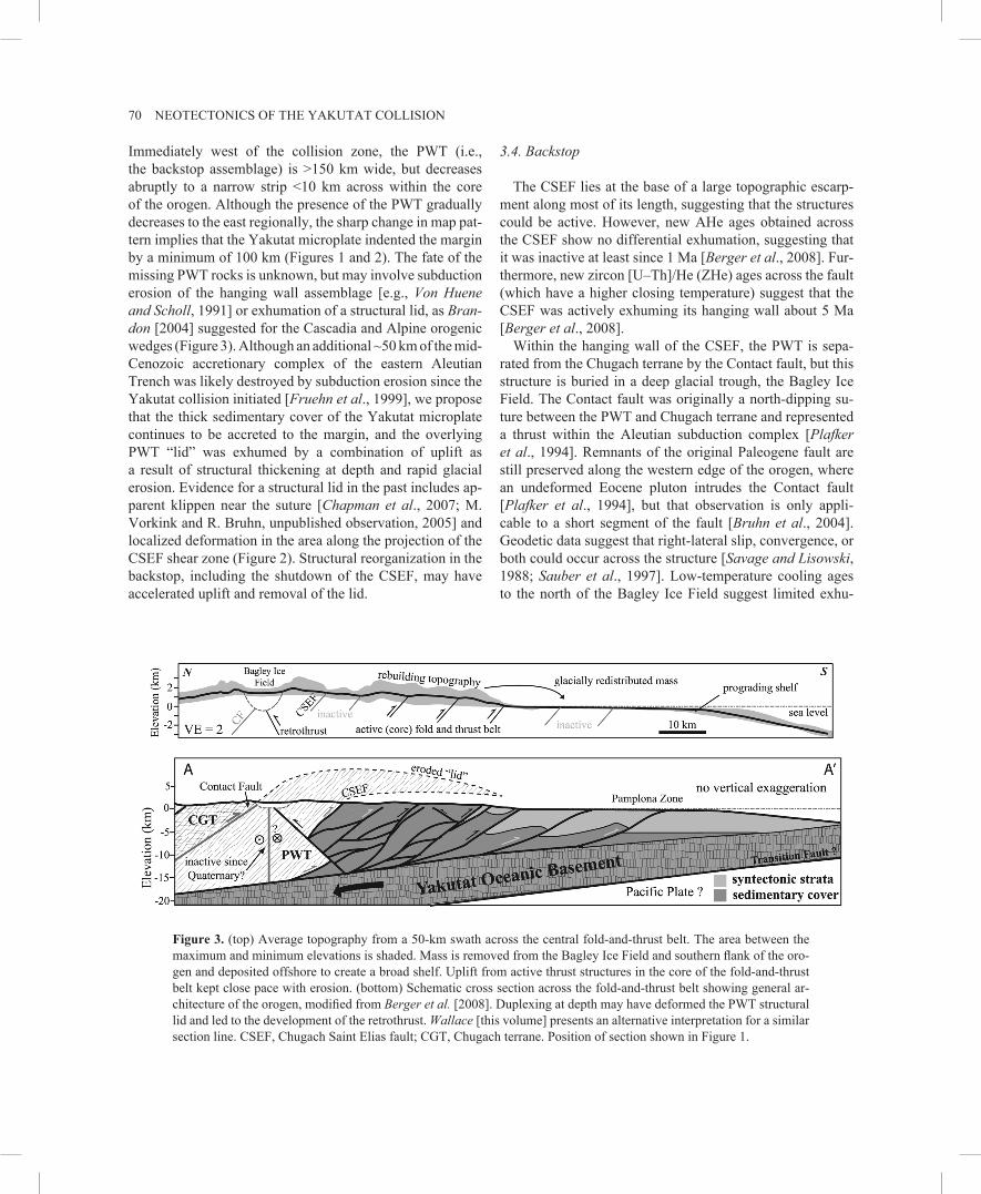
70 NEOTECTONICS OF THE YAKUTAT COLLISION
Immediately west of the collision zone, the PWT (i.e., the backstop assemblage) is >150 km wide, but decreases abruptly to a narrow strip <10 km across within the core of the orogen. Although the presence of the PWT gradually decreases to the east regionally, the sharp change in map pattern implies that the Yakutat microplate indented the margin by a minimum of 100 km (Figures 1 and 2). The fate of the missing PWT rocks is unknown, but may involve subduction erosion of the hanging wall assemblage [e.g., Von Huene and Scholl, 1991] or exhumation of a structural lid, as Bran-don [2004] suggested for the Cascadia and Alpine orogenic wedges (Figure 3). Although an additional ~50 km of the mid Cenozoic accretionary complex of the eastern Aleutian Trench was likely destroyed by subduction erosion since the Yakutat collision initiated [Fruehn et al., 1999], we propose that the thick sedimentary cover of the Yakutat microplate continues to be accreted to the margin, and the overlying PWT “lid” was exhumed by a combination of uplift as a result of structural thickening at depth and rapid glacial erosion. Evidence for a structural lid in the past includes apparent klippen near the suture [Chapman et al., 2007; M. Vorkink and R. Bruhn, unpublished observation, 2005] and localized deformation in the area along the projection of the CSEF shear zone (Figure 2). Structural reorganization in the backstop, including the shutdown of the CSEF, may have accelerated uplift and removal of the lid.
3.4. Backstop
The CSEF lies at the base of a large topographic escarpment along most of its length, suggesting that the structures could be active. However, new AHe ages obtained across the CSEF show no differential exhumation, suggesting that it was inactive at least since 1 Ma [Berger et al., 2008]. Furthermore, new zircon [U–Th]/He (ZHe) ages across the fault (which have a higher closing temperature) suggest that the CSEF was actively exhuming its hanging wall about 5 Ma [Berger et al., 2008].
Within the hanging wall of the CSEF, the PWT is separated from the Chugach terrane by the Contact fault, but this structure is buried in a deep glacial trough, the Bagley Ice Field. The Contact fault was originally a northdipping suture between the PWT and Chugach terrane and represented a thrust within the Aleutian subduction complex [Plafker et al., 1994]. Remnants of the original Paleogene fault are still preserved along the western edge of the orogen, where an undeformed Eocene pluton intrudes the Contact fault [Plafker et al., 1994], but that observation is only applicable to a short segment of the fault [Bruhn et al., 2004]. Geodetic data suggest that rightlateral slip, convergence, or both could occur across the structure [Savage and Lisowski, 1988; Sauber et al., 1997]. Lowtemperature cooling ages to the north of the Bagley Ice Field suggest limited exhu
Figure 3. (top) Average topography from a 50km swath across the central foldandthrust belt. The area between the maximum and minimum elevations is shaded. Mass is removed from the Bagley Ice Field and southern flank of the orogen and deposited offshore to create a broad shelf. Uplift from active thrust structures in the core of the foldandthrust belt kept close pace with erosion. (bottom) Schematic cross section across the foldandthrust belt showing general architecture of the orogen, modified from Berger et al. [2008]. Duplexing at depth may have deformed the PWT structural lid and led to the development of the retrothrust. Wallace [this volume] presents an alternative interpretation for a similar section line. CSEF, Chugach Saint Elias fault; CGT, Chugach terrane. Position of section shown in Figure 1.

CHAPMAN ET AL. 71
mation (≤2.5 km) within the Chugach terrane for most of the history of the Saint Elias orogen, yet ages to the south of the Bagley Ice Field are significantly younger, indicative of sustained southside up motion across the Contact fault boundary [Berger et al., 2008; Spotila et al., 2004; John-ston et al., 2004; Berger and Spotila, submitted manuscript]. Recent earthquake locations by Doser et al. [2007] reveal a prominent southdipping seismicity trend in the vicinity of the Bagley Ice Field that Berger et al. [2008] interpret as a previously unrecognized backthrust to explain the AHe ages. The development and initiation of significant motion on the backthrust may coincide with the shutdown of the CSEF and formation of a new mechanical backstop.
Metamorphic grade within the hanging wall of the CSEF increases markedly from west to east, reaching upper amphibolite facies near Mt. Saint Elias [Dusel-Bacon et al., 1994]. The field gradient along the Yakutat suture (i.e., CSEF) probably reflects an increase in total exhumation, consistent with high topography to the east [Sisson et al., 1989]. The relative activity and interactions between the CSEF, Contact fault, proposed backthrust, and Fairweather fault to produce the high topography at this eastern junction is poorly understood [Chapman et al., 2007]. The region experienced a complex rupture pattern during the 1979 Saint Elias earthquake (Mw = 7.4), which included thrust and strikeslip motion in the backstop and numerous thrustrelated aftershocks in the foreland [Estabrook et al., 1992].
3.5. Central Segment: Fold-and-Thrust Belt
Seaward of the CSEF are a series of stacked thrust sheets that display progressively younger strata toward the offshore deformation front in the Pamplona zone [Plafker, 1987]. The synorogenic deposits of the Yakataga Formation are absent in the structurally highest thrust sheets, progressively young toward the coast, and actively deforming offshore [Plafker, 1987; Plafker et al., 1994]. These observations are broadly consistent with the general stacking succession recognized in most foldand thrust belts, accretionary complexes, and orogenic wedges where surface morphology and structure are closely correlated [e.g., Elliot, 1976; Davis et al., 1983]. Figure 3 presents a schematic cross section across the central segment in line with these more traditional interpretations of an accretionary style orogen and previous crosssection constructions [Plafker, 1987, 1994]. This interpretation differs from that of Wallace [this volume] by the inclusion of the retrothrust beneath the Bagley Ice Field [Berger et al., 2008] and significant internal shortening and duplexing within the sedimentary cover rather than a regional detachment at moderate depth above basement horses. Ongoing and planned
geophysical work may help to resolve the role of basement in the orogen [Bauer et al., 2007]. Line length restoration of just the Yakataga Formation and a reasonable restoration of the Bagley Ice Field backthrust suggest ~25 km shortening since 3–5 Ma (corresponding to 5–8.5 mm/a), comparable to the total shortening proposed by Wallace [this volume]. In our interpretation, area balance restoration of all the sedimentary cover suggests a minimum of 75 km shortening, which is still far short of the 120 to 250km convergence estimated for that period based on plate motion reconstructions [Pavlis et al., 2004]. Much of that deformation was likely taken up on thrusts higher in the structural succession and subsequently eroded. Assuming limited surface uplift, inclusion of exhumation estimates from Berger et al. [2008] since 3–5 Ma results in ~200–300 km shortening. Other possibilities for missing shortening include strikeslip motion and sediment subduction along the CSEF.
AHe age distributions and river channel analyses suggest that deformation is focused within the core of the foldandthrust belt and not directly linked to orogenic topography (Figure 3) [Berger et al., 2008; Chapman and Vorkink, 2006]. The spatial distribution of high exhumation rates (~5 mm/a) is roughly coincident with the intersection between topography and the glacial equilibrium line altitude (ELA) [Berger et al., 2008; Spotila et al., 2004; Berger and Spotila, submitted manuscript]. In temperate (warmbased) glacial systems, erosion is thought to be greatest at the ELA where the basal sliding velocity is highest [Hallet, 1979; Meigs and Sauber, 2000]. Thus, focused glacial erosion and tectonics should be coupled whereby the mean topographic slope of the orogenic wedge is preserved by enhanced exhumation at the ELA [Berger et al., 2008; Tomkin, 2007; Berger and Spotila, submitted manuscript]. An important consequence of this arrangement is that active deformation migrated away from the outboard deformation front toward the interior of the foldandthrust belt onshore in response to increased glacial erosion and exhumational forcing.
Previous structural analyses of selected thrust faults in the central segment showed that slip was largely orthogonal to the margin, or roughly north–south and oblique to total Yakutat motion [Bruhn et al., 2004]. This observation led researchers to suggest that marginparallel motion was partitioned into the backstop or elsewhere within the orogen [Bruhn et al., 2004; Pavlis et al., 2004]. However, recent work discussed below suggests that active deformation is reactivating or overprinting older ~E–W-striking structures. There are large local variations in the strike of the structural grain in the foldandthrust belt and thrust sheets tip out to the east corresponding to a decrease in orogen width ranging from >100 km in the west to less than 10 km at the easternmost extent. Deviations in strike may represent
72 NEOTECTONICS OF THE YAKUTAT COLLISION
lateral to oblique thrust ramps, but may be related to renewed faulting across older structures. Topography within the foldandthrust belt also exhibits a strong NE trend with ridges and valleys that cross-cut mapped ~E–W-striking structures (Figure 4) [Chapman and Vorkink, 2006]. AHe age distributions [Berger et al., 2008] and recent field mapping within the core of the foldandthrust belt suggest that some of these topographic features may be structurally controlled. Furthermore, gently plunging fold axes, stratigraphic relationships, drainage asymmetry studies, and tilted marine terraces suggest downtothewest regional tilting [Hudson et al., 1976; Bruhn et al., 2004; Chapman and Vorkink, 2006; Chapman et al., 2007], consistent with backrotation along thrust ramps dipping to the northwest. Thus, a slippartitioned, ~E–W-striking thrust system appears to have structurally reorganized into an en echelon array of NEstriking thrusts oriented perpendicular to total Yakutat microplate motion.
The pattern of structural reorganization is also present in the offshore foldandthrust belt as imaged by seismic data. A thick section of undeformed Quaternary sediments overlies older growth strata, suggesting limited offshore deformation in the central segment [Bruns and Schwab, 1983; Zellers, 1995; Lowe et al., this volume]. Significantly, the older folds beneath this younger, flat-lying sequence strike ~E–W [Bruns and Schwab, 1983], subparallel to older structures within the onshore foldandthrust belt and oblique to actively deforming folds of the Kayak Island and Pamplona zones.
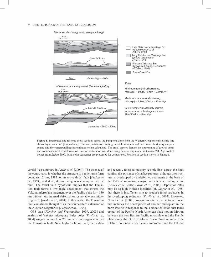
3.6. Pamplona Zone
The NEtrending Pamplona zone is widely considered the offshore deformation front [Lahr and Plafker, 1980; Bruns and Schwab, 1983], which some researchers suggest is the present surface expression of the Aleutian Megathrust that migrated eastward in time [Perez and Jacob, 1980; Plafker et al., 1987]. Both the Pamplona zone and its onshore equivalent, the Malaspina fault, cut obliquely across the topographic grain and are considered active [Bruns and Schwab, 1983; Estabrook et al., 1992] (Figure 5). The Malaspina fault likely ruptured as a result of aftershocks from the 1979 Saint Elias earthquake [Estabrook et al., 1992], and the Pamplona zone ruptured in a series of M = 5.0–6.7 earthquakes in 1970 [Doser et al., 1997]. The remainder of the central segment is currently considered a seismic gap [Sav-age and Lisowski, 1988] with the last major event occurring in 1899 with at least one M = 8+ earthquake [Tarr and Mar-tin, 1912; Thatcher and Plafker, 1982, this volume]. GPS velocities show a 15 to 20mm/a decrease across the entire onshore foldandthrust belt [Sauber et al., 1997], and Lahr and Plafker [1980] calculate that the region has since ac
cumulated enough strain to produce an M = 8 earthquake if released at once.
In a typical orogenic wedge, the frontal thrust system would take up much, if not all, of the convergence along the foldandthrust belt [e.g., Suppe, 1981] and many studies interpret the Pamplona zone in this light. Bruns [1983] and Plafker [1987] suggest 4–10 km of convergence across the Pamplona zone in the Pleistocene, and Lahr and Plafker [1980] suggest that currently there may be up to 44 mm/a of convergence. Recent work by Lowe et al. [this volume] also proposed that the Pamplona zone is the active deformation front, although not a dominant deformational feature, an interpretation consistent with deformation concentrated elsewhere within the orogen.
Analyses of an industry seismic line across the Pamplona zone together with biostratigraphic age control from a nearby well [Zellers, 1993, 1995; Picornell, 2001; Lowe et al., this volume] provide important constraints on the amount of deformation taken up in the Pamplona zone. Figure 5 shows two alternative interpretations of an industry seismic line offshore from Cape Yakataga (Figure 1). The upper section shows an interpretation consistent with most previous interpretations of these structures [Bruns and Schwab, 1983; Risley et al., 1992; Zellers, 1993; Lowe et al., this volume], and restoration of these simple folds (upper middle section, Figure 5) indicates ~600 m of shortening. The lower sections, however, show a deformed and restored section representing an endmember faultbend fold model of the maximum allowable shortening for this section that is consistent with both the seismic data and the well control. This maximum slip model suggests that up to 3–4.5 km of slip could be accommodated at the deformation front in this region. The range of slip magnitudes inferred by these endmember sections is important because if we apply Zeller’s [1993, 1995] sequences and their associated ages from well control to the growth strata developed on these folds, this analysis indicates that the shortening rate across these structures is somewhere between 0.4 and 15 mm/a, with a preferred estimate of ~6 mm/a (Figure 5). This observation is the basis for the conclusion of Picornell [2001] and Pavlis et al. [2004] that only a fraction (10–20%) of the total convergence is taken up on the Pamplona zone and the remainder of the motion must be taken up on other structures in the interior of the orogen.
3.7. Transition Fault
South of the Pamplona zone, the Transition fault places the Oligocene Pacific crust against the Mesozoic and Paleogene basement of the Yakutat microplate [Bruns, 1983]. The nature and neotectonic status of the Transition fault is contro

CHAPMAN ET AL. 73
Figu
re 4
. Slo
pe m
ap o
f the
cent
ral s
egm
ent o
f the
Sai
nt E
lias o
roge
n an
d hi
stog
ram
show
ing
the b
imod
al d
istri
butio
n of
topo
grap
hic
trend
s w
ithin
the
orog
en. ~
E–W
-tren
ding
topo
grap
hy is
rela
ted
to o
lder
, ina
ctiv
e st
ruct
ures
suc
h as
the
Chu
gach
Sai
nt E
lias
faul
t (C
SEF)
or o
lder
, rea
ctiv
ated
stru
ctur
es su
ch a
s the
retro
thru
st w
ithin
the
Bag
ley
Ice
Fiel
d th
at o
ccur
s alo
ng th
e tra
ce o
f the
Con
tact
fa
ult.
Topo
grap
hy b
etw
een
the
Ber
ing
and
Mal
aspi
na G
laci
ers
exhi
bits
an
~NE
trend
nea
rly o
rthog
onal
to to
tal Y
akut
at m
otio
n an
d is
rela
ted
to a
pro
pose
d en
ech
elon
arr
ay o
f thr
ust f
aults
such
as t
he M
alas
pina
faul
t and
Hop
e C
reek
faul
t (H
CF)
. Top
ogra
phic
m
etric
s wer
e ex
tract
ed fr
om a
60
m D
igita
l Ele
vatio
n M
odel
(DEM
) han
dch
ecke
d fo
r con
sist
ency
. Loc
atio
n sh
own
in F
igur
e 1.
74 NEOTECTONICS OF THE YAKUTAT COLLISION
versial (see summary in Pavlis et al. [2004]). The essence of the controversy is whether the structure is a relict transform boundary [Bruns, 1983] or an active thrust fault [Plafker et al., 1994], and if so, if shortening is occurring across the fault. The thrust fault hypothesis implies that the Transition fault forms a lowangle decollement that thrusts the Yakutat microplate basement over the Pacific plate for ~150 km without any internal deformation or notable seismicity (Figure 3) [Bruhn et al., 2004]. In this model, the Transition fault can also be thought of as the southeastern extension of the Aleutian Megathrust [Plafker et al., 1994].
GPS data [Fletcher and Freymueller, 1999, 2003] and analysis of Yakutat microplate Euler poles [Pavlis et al., 2004] suggest as much as 20 mm/a of convergence across the Transition fault. New highresolution bathymetry data
and recently released industry seismic lines across the fault confirm the existence of surface ruptures, although the structure is overlapped by undeformed sediments at the base of the Yakutat submarine canyon and elsewhere along strike [Gulick et al., 2007; Pavlis et al., 2004]. Deposition rates may be so high in these localities [cf. Jaeger et al., 1998] that there is insufficient slip to produce finite structures in the overlapping sediments [Pavlis et al., 2004]. However, Gulick et al. [2007] propose an alternative tectonic model that includes the development of another microplate in the north Pacific in response to the Yakutat collision that takes up part of the Pacific–North American plate motion. Motion between the new Eastern Pacific microplate and the Pacific plate along the Gulf of Alaska Shear Zone requires little relative motion between the new microplate and the Yakutat
Figure 5. Interpreted and restored cross sections across the Pamplona zone from the Western Geophysical seismic line shown by Lowe et al. [this volume]. The interpretations resulting in total minimum and maximum shortening are presented and the corresponding shortening rates are calculated. The small arrows demark the appearance of growth strata and commencement of deformation. Section restoration was done using flexural slip model in Geosec 2D. Age control comes from Zellers [1993] and color sequences are presented for comparison. Position of section shown in Figure 1.

CHAPMAN ET AL. 75
microplate, decreasing the convergence rate and negating some of the need for exceptionally high sedimentation rates [Gulick et al., 2007] (Figure 1).
Seismicity and seafloor scarps suggest that at least the southeastern end of the Transition fault is active [Doser and Lomas, 2000; Gardner, 2006], which Gulick et al. [2007] interpret as a result of stalled subduction of Yakutat basement and the transfer of translational motion from the Fairweather fault. The timing of this event is unclear, but it may be coincident with structural reorganization elsewhere in the orogen.
4. DISCUSSION
A longstanding problem in the Saint Elias orogen is the apparent disconnect between areas of deformation, particularly between the mapped geology onshore and seismically imaged structures offshore [Plafker, 1987; Risley et al., 1992]. Based on the recent work reviewed above, we suggest that active deformation is not spatially equivalent to cumulative finite deformation in the past and that the orogen experienced a complex structural reorganization. Active structures have shifted in time in a manner inconsistent with normal orogenic growth [e.g., Suppe, 1981; Hoth et al., 2006]. We posit that these changes are in part driven by mass redistribution as a result of intense glacial erosion during the Quaternary [Berger et al., 2008]. Within this framework, a selfconsistent tectonic model emerges that incorporates the temporal evolution of deformation to explain the present tectonic configuration. Key observations linking active deformation throughout the orogen are presented below, followed by a tectonic synthesis.
4.1. Key Observations
The geology of the Yakutat microplate is reasonably well known from regional mapping [Plafker, 1987, 2005; Bruhn et al., 2004], but recent fieldwork and geochronology show that active deformation is concentrated within the core of the orogen. In the central foldandthrust belt, a series of en echelon, NEstriking thrust structures accommodate oblique dextral convergence [Chapman and Vorkink, 2006]. Slip appears to decrease along strike, forming a linear deformation front parallel to the margin [Berger et al., 2008]. To the west of the Bering Glacier structure, this band of deformation continues, although with a markedly different structural style. An incipient “indentor corner,” similar to the Himalayan syntaxes [e.g., Zeitler et al., 2001], is forming at the western edge of the Yakutat microplate collision [Pavlis et al., 2004]. A complex combination of distributed surface ruptures and verticalaxis folding are currently taking up convergence in this corner [Bruhn et al., 2006; Pavlis et al.,
2004]. In the foldandthrust belt and western syntaxis, active structures are overprinting and partially reactivating older, ~E–W-striking fold-and-thrust structures. Offshore, structures with this E–W trend are blanketed by undeformed sediments [Bruns and Schwab, 1983].
The shutdown of ~E–W-striking structures is coincident in age with the deposition of a thick glaciomarine sedimentary succession almost entirely Pleistocene in age [Zellers, 1995], suggesting a link between sedimentation and tectonics [Lowe et al., this volume]. Moreover, the present continental shelf is anomalously wide (~150 km) for a convergent setting, leading some researchers to suggest that deposition grossly outpaced convergence, resulting in the rapid progradation of the shelf during this period [Zellers, 1995; Bird, 1996]. Debate continues on the causeandeffect linkages between uplift, erosion, and climatic cooling [e.g., Molnar and England, 1990]. However, it is clear that vigorous glacial erosion within the orogen during the Pleistocene produced exceptionally large volumes of sediment that were redistributed offshore.
The source area for this sediment is predominately the southern (windward) flank of the orogen, but also includes the Bagley Ice Field within the backstop that feeds the Bering Glacier (Figure 1). Recent radar surveys across the >100km long Bagley Ice Field suggest that the glacial trough is up to 2 km deep (B. Hallet, unpublished data, 2007), representing a major possible sediment source. In the central foldandthrust belt, the region most applicable to orogenic wedge models, longwavelength surface morphology is sigmoidal [Chapman and Vorkink, 2006], consistent with glacial excavation, and thermochronology studies suggest that >3 km of material was exhumed in the last 1 Ma in this area (Berger and Spotila, submitted manuscript). The western syntaxis area is most representative of widespread erosion in the Pleistocene with scattered, rounded island uplands at low elevations surrounded by marshy, abandoned glacial outwash plains. Furthermore, seismic data reveal eroded fold andthrust systems just offshore of the western segment [Bruns and Schwab, 1983]. Thus, it appears there was a net transfer of mass from the southern flank (and possibly backstop) of the Saint Elias orogen into offshore depositional systems that are constructing the continental shelf.
4.2. Tectonic Synthesis
Collectively, these observations lead us to a working model for the tectonic evolution of the orogen. Our interpretation considers the present pattern of active deformation together with a reconstruction of the orogen to the latest Pliocene (Figure 6). The latter uses the reconstruction scheme of Pav-lis et al. [2004], but includes new syntheses of the temporal and kinematic development of this system.

76 NEOTECTONICS OF THE YAKUTAT COLLISION
Figure 6. Tectonic reconstruction from the latest Pliocene to the present. See Section 4.2 for discussion. CSEF, Chugach Saint Elias fault; PWT, Prince William Terrane; YKT, Yakutat microplate.

CHAPMAN ET AL. 77
The initiation of local orogenesis in the late Miocene to Pliocene resulted in a stacked succession of thrust sheets as the Yakutat microplate sedimentary cover was stripped from basement (Figure 6a). The CSEF (suture) was the structurally highest thrust sheet and formed a northdipping structural lid (Figures 2 and 3) under which the Yakutat microplate began to accrete. Outboard of the CSEF were a series of ~E–W-striking thrusts that defined the topographic slope of the orogen (Figure 6a). Oblique convergence was partitioned into marginnormal dipslip on these structures and dextral strikeslip on faults beneath the Bagley Ice Field [Bruhn et al., 2004]. Thrust sheets tipped out to the east and net convergence increased to the west as a function of the transition from strikeslip in the east to subduction in the west.
In the late Pliocene to early Pleistocene, the orogen underwent an extensive structural reorganization. In the backstop, the CSEF shutdown and significant retrothrust motion began on a southdipping structure beneath the Bagley Ice Field, resulting in a doubly vergent orogen (Figure 6b) [Berger et al., 2008]. Offshore, ~E–W-striking fold-and-thrust structures shut down and activity shifted to ~NEtrending deformation zones at the edges of depocenters (i.e., the Kayak Island zone, Pamplona zone, or onshore) (Figure 6b). Onshore, the foreland foldandthrust belt developed ~NEstriking thrusts, orthogonal to total Yakutat microplate motion, which accommodated the strikeslip motion previously absorbed by structures beneath the Bagley Ice Field (Figure 6c). These structures overprinted or reactivated the older ~E–W-striking structures and formed an en echelon thrust array parallel to the margin. In the western segment, the ~E–W fold-and-thrust system was fed into a developing syntaxis recorded by the formation of the Bering Glacier fault and secondphase folding of structures (Figure 6c).
The timing of structural reorganization within the orogen is concurrent with repeated northern hemispheric glaciations in the Pleistocene, a linkage we suggest is not coincidental [Pavlis et al., 2004, Gulick et al., 2007; Lowe et al., this volume; Berger et al., 2008]. There were at least 10–15 advance/retreat cycles in the Pleistocene related to climatic fluctuations in southern Alaska [Hamilton, 1994; Calkin et al., 2001]. Large variability in glacial coverage is important because changes in the ELA are manifested as spatial shifts in the maximum erosion potential, linking ELA to mean topographic elevation [Meigs and Sauber, 2000; Mitchell and Montgomery, 2006]. During glacial cycles, particularly when accompanied by a fall in sea level, ice masses advanced across the orogenic front, sculpting the present topography through development of piedmont glaciers and ice streams (Figure 6b).
The combined effect of these processes was the disruption of orogenic topography and widespread mass redistribution
offshore to construct a depositional shelf (Figure 6b). We propose that rapid sedimentation in depocenters locally stabilized the orogenic wedge by decreasing topographic slope and increasing normal stress on decollement surfaces [Storti and McClay, 1995; Fuller et al., 2006]. While internal deformation was suppressed, strain was focused at the margins of the depocenter [Storti and McClay, 1995; Stockmal et al., 2006]. The result is the shutdown of offshore ~E–W-striking thrust structures and an increase in activity along the Kayak Island zone, Pamplona zone, and, most significantly, the onshore foldandthrust belt.
Backstepping of the active deformation front toward the hinterland by means of outofsequence reactivation [Chap-man et al., 2007] and overprinting of thrust structures was reinforced by concentrated glacial erosion, which together narrowed the active portion of the orogenic wedge by ~50 km [cf. Willet, 1999; Whipple and Meade, 2004]. The timing of mobilized deformation and rapid sedimentation is coincident with the exhumation and continuing destruction of the structural lid, likely resulting from the development or increased activity on the proposed retrothrust beneath the Bagley Ice Field (J. A. Berger and A. L. Spotila, unpublished data). The Bagley Ice Field is currently a deep glacial trough that feeds the Bering and Malaspina piedmont glaciers. We suggest that these ice streams act as a lateral conveyor belt for surficial mass transport in a manner similar to rivers in other highly active orogenic systems [Pavlis et al., 1997; Zeitler et al., 2001]. That is, uplift/convergence and erosion are competing processes that continue to focus deformation in the core of the mountain belt.
The commencement of significant retrothrust motion fun-damentally altered stress orientations and particle paths within the orogen, possibly leading to the present system where convergence is accommodated by a narrow band of en echelon thrusts (Figure 6c). Oblique thrusting in response to transpressional collision in a doubly vergent orogen is consistent with rotating stress orientations in mechanical analyses [Koons, 1994] and is observed in the Southern Alps [Norris et al., 1990], which Koons et al. [2003] attribute to advective weakening related to orographically concentrated exhumation. While uplift by thrust stacking and duplexing at depth (Figure 3) in the central segment could keep close pace with erosion, the complex western syntaxis, which involves significant strike-slip and vertical-axis refolding, could not. As a result, we tentatively suggest that the lack of topographic control in the western segment produced widely dispersed deformation.
It is important to recognize that this model is a working hypothesis and is subject to significant changes as more information accumulates. Studies in progress and planned as part of STEEP should provide direct tests of the model.

78 NEOTECTONICS OF THE YAKUTAT COLLISION
Whereas many of the linkages between glaciation, sedimentation, and deformation are provocative, timing constraints are limited by offshore sedimentation [Lowe et al., this volume] and thermochronology studies [Berger et al., 2008]. Recovery of a highresolution sedimentary record through offshore drilling may prove critical to unraveling the details of how global climate change and glaciation impact orogenesis. In addition, there are many unresolved questions concerning the tectonics of the Saint Elias orogen including the role of the Transition fault [Gulick et al., 2007] and the nature of complex structural and erosional interactions in the eastern syntaxis area.
4.3. Seismic Hazard Assessments
The Saint Elias orogen contains a prominent seismic gap that last ruptured during a series of great earthquakes in 1899 [Savage and Lisowski, 1988; Tarr and Martin, 1912]. GPS data indicate relatively uniform movement across the orogen consistent with elastic loading on a lowangle thrust interface [Sauber et al., 1997; Fletcher and Freymueller, 1999, 2003; Leonard et al., 2007]. This structure is widely assumed as a decollement separating basement from sedimentary cover along the flat slab interface [e.g., Plafker et al., 1994], although the potential for loading on the proposed retrothrust [Berger et al. 2008] is unexplored. Geologic and neotectonic studies suggest that deformation patterns within the cover sequence are more complex. A likely scenario is that periodic slip in great earthquakes along the decollement is the driver for the system in which cover deforms through a series of smaller earthquakes, fault creep events, or both, to collectively produce the surface deformation observed. Thus, earthquake hazard assessments for the region should consider both the potential of a megathrust event on the flat slab interface and many smaller events related to the complexities of structural reactivations and changing stress orientations in response to evolving topography.
5. CONCLUSIONS
The Yakutat collision is driving orogenesis throughout southern Alaska and constructed the Saint Elias orogen in a tectonic corner defined by the transition from strike-slip on the Fairweather fault to subduction at the eastern end of the Aleutian Trench. The orogen experienced a structural reorganization in the Quaternary when a slippartitioned, forwardbreaking foldandthrust belt evolved into the present configuration, where oblique convergence is largely accommodated by a narrow band of en echelon thrust struc
tures as part of a doubly vergent wedge. We propose that the impetus for this reorganization was intense glacial erosion and rapid sedimentation during the Pleistocene, which disrupted orogenic topography causing complex shifts in nearsurface deformation. The region appears to pose two distinct types of seismic hazards: a potential for a megathrust event on the flat slab decollement beneath the orogen, and many smaller events on the complex, actively deforming fault arrays within the cover sequence.
REFERENCES
Bauer, M. A., G. L. Pavlis, and R. Hansen (2007), Crustal thickness estimates for the Chugach–St. Elias, Alaska, region from receiver functions, Eos Trans. AGU, Fall Meet. Suppl., Abstract S33A1040.
Berger, A. L., J. Spotila, J. Chapman, T. Pavlis, E. Enkelmann, and J. Buscher (2008), Architecture, kinematics, and exhumation of a convergent wedge: A thermochronological investigation of tectonicclimatic interactions within the central St. Elias Orogen, Alaska, Earth Planet. Sci. Lett., 270, 13–24.
Bird, P. (1996), Computer simulations of Alaskan neotectonics, Tectonics, 15, 225–236.
Brandon, M. T. (2004), The Cascadia subduction wedge: The role of accretion, uplift, and erosion, in Earth Structure, An Introduc-tion to Structural Geology and Tectonics, pp. 566–574, WCB/McGraw Hill Press, New York.
Bruhn, R. L., T. L. Pavlis, G. Plafker, and L. Serpa (2004), Deformation during terrane accretion in the Saint Elias orogen, Alaska, Geol. Soc. Am. Bull., 116, 771–787.
Bruhn, R. L., J. McCalpin, T. Pavlis, F. Gutierrez, J. Guerrero, P. Lucha, and M. Vorkink (2006), Active tectonics of western Saint Elias Orogen, Alaska: Integration of LIDAR and field geology, Eos Trans. AGU, Fall Meet. Suppl., Abstract G53C0922.
Bruns, T. R. (1983), Model for the origin of the Yakutat block, an accreted terrane in the northern Gulf of Alaska, Geology, 11, 718–721.
Bruns, T. R., and W. C. Schwab (1983), Structure maps and seismic stratigraphy of the Yakataga segment of the continental margin, northern Gulf of Alaska, U.S. Geol. Surv. Misc. Field Stud. Map, MF-1424, 25 pp.
Calkin, P. E., G. C. Wiles, and D. J. Barclay (2001), Holocene coastal glaciation of Alaska, Quat. Sci. Rev., 20, 449–461.
Chapman, J. B., and M. Vorkink (2006), Tectonic geomorphology in an orogen dominated by glacial erosion, Saint Elias Mountains, Alaska, Chapman Conference: Active Tectonics and Seismic Potential of Alaska, AGU, Girdwood, Alaska.
Chapman, J. B., T. L. Pavlis. T. L., A. Barker, R. Headley, K. Ridgway, A. Berger, J., Spotila, M. Vorkink, and R. Bruhn (2007), Tectonics and structural evolution of the eastern St. Elias syntaxis, Alaska, Geol. Soc. Am. Abstr. Programs, 39(6), Abstract 18123.
Davis, D., J. Suppe, and F. Dahlen (1983), Mechanics of foldandthrust belts and accretionary wedges, J. Geophys. Res., 88, 1153–1172.

CHAPMAN ET AL. 79
DeMets, C., R. G. Gordon, D. F. Argus, and S. Stein (1994), Effect of recent revisions of geomagnetic reversal timescale on estimate of current plate motions, Geophys. Res. Lett., 21, 2191– 2194.
Doser, D. I., and R. Lomas (2000), The transition from strikeslip to oblique subduction in southeastern Alaska from seismological studies, Tectonophysics, 316, 45–65.
Doser, D. I., J. R. Pelton, and A. M. Veilleux (1997), Earthquakes in the Pamplona zone, Yakutat Block, southcentral Alaska, J. Geophys. Res., 102, 24,499–24,511.
DuselBacon, Cynthia (1994), Metamorphic history of Alaska, in The Geology of North America: The Geology of Alaska, edited by G. Plafker and H. C. Berg, pp. 495–533, Geol. Soc. of Am., Boulder, Colo.
EberhartPhillips, D., D. H. Christensen, T. M. Brocher, R. Hansen, N. A. Ruppert, P. J. Haeussler, and G. A. Abers (2006), Imaging the transition from Aleutian subduction to Yakutat collision in central Alaska, with local earthquakes and active source data, J. Geophys. Res., 111, B11303, doi:10.1029/2005JB004240.
Elliot, D. (1976), The energy balance and deformation mechanisms of thrust sheets, Philos. Trans. R. Soc. Lond. A., 283, 289–312.
Estabrook, C. H., J. L. Nábělek, and J. L. Lerner-Lam (1992), Tectonic model of the Pacific–North American plate boundary in the Gulf of Alaska from broadband analysis for the 1979 St. Elias, Alaska, earthquake and its aftershocks, J. Geophys. Res., 97, 6587–6612.
Eyles, C. H., and M. B. Lagoe (1990), Sedimentation patterns and facies geometries on a temperate glacially-influenced continental shelf: The Yakataga Formation, Middleton Island, Alaska, in Glacimarine Environments: Processes and Sediments, edited by J. A. Dowdeswell and J. D. Scourse, Geol. Soc. Spec. Publ., 53, 363–386.
Eyles, C. H., N. Eyles, and M. B. Lagoe (1991), The Yakataga Formation, a late Miocene to Pleistocene record of temperate glacial marine sedimentation in the Gulf of Alaska, in Glacial-marine sedimentation, paleoclimatic significance, edited by Anderson, J. B., and G. M. Ashley, Geol. Soc. Am. Spec. Pap., 261, 159–180.
Fitzgerald, P. G., E. Stump, and T. F. Redfield (1993), Late Cenozoic uplift of Denali and its relation to relative plate motion and fault morphology, Science, 259, 497–499.
Fletcher, H. J., and J. T. Freymueller (1999), New GPS constraints on the motion of the Yakutat Block, Geophys. Res. Lett., 26, 3029–3032.
Fletcher, H. J., and J. T. Freymueller (2003), New constraints on the motion of the Fairweather fault, Alaska, from GPS observations, Geophys. Res. Lett., 30(3), 1139, doi:10.1029/2002GL016476.
Fruehn, J., R. von Huene, and M. A. Fisher (1999), Accretion in the wake of terrane collision: The Neogene accretionary wedge off Kenai Peninsula, Alaska, Tectonics, 18, 263–277.
Fuller, C., S. D. Willett, and M. T. Brandon (2006), Formation of forearc basins and their influence on subduction zone earthquakes, Geology, 34, 65–68.
Gulick, S. P. S., L. Lowe, T. L. Pavlis, J. V. Gardner, and L. A. Mayer (2007), Geophysical insights into the Transition fault
debate: Propagating strikeslip in response to stalling Yakutat block, Geology, 35, 763–766.
Hallet, B. (1979), A theoretical model of glacial abrasion, J. Gla-ciol., 23, 39–50.
Hamilton, T. D. (1994), Late Cenozoic glaciation of Alaska, in The Geology of North America: The Geology of Alaska, edited by G. Plafker and H. C. Berg, pp. 813–844, Geol. Soc. of Am., Boulder, Colo.
Hoth, S., J. Adam, N. Kukowshi, O. Oncken (2006), Influence of erosion on the kinematics of bivergent orogens: Results form scaled sandbox simulations, in Tectonics, Climate, and Land-scape Evolution, edited by S. D. Willett, N. Hovius, M. Brandon, and D. M. Fisher, Geol. Soc. Am. Spec. Pap., 398, 201–225.
Jaeger, J. M., C. A. Nitrouer, N. D. Scott, and J. D. Milliman (1998), Sediment accumulation along a glacially impacted mountainous coastline: Northeast Gulf of Alaska, Basin Res., 10, 155–173.
Johnston, S., A. Meigs, J. Garver, and J. Spotila (2004), Backstop and orogenic wedge cooling histories in the active Yakutat Terrane collision, Southern Alaska, Geol. Soc. Am. Abstr. Programs, 36(5), Abstract 1126.
Koons, P. O. (1994), Threedimensional critical wedges: Tectonics and topography in oblique collisional orogens, J. Geophys. Res., 99(B6), 12,301–12,315.
Koons, P. O., R. J. Norris, D. Craw, and A. F. Cooper (2003), Influence of exhumation on the structural evolution of transpressional plate boundaries: An example from the Southern Alps, New Zealand, Geology, 31, 3–6.
Lahr, J. C., and G. Plafker (1980), Holocene Pacific–North American plate interaction in southern Alaska: Implications for the Yakataga seismic gap, Geology, 8, 483–486.
Larsen, C. F. (2006), Geology and seismology of the Saint Elias orogen and southeastern Alaska, Chapman Conference: Active Tectonics and Seismic Potential of Alaska, AGU, Girdwood, Alaska.
Leonard, L. J., R. D. Hyndman, S. Mazzotti, L. Nykolaishen, M. Schmidt, and S. Hippchen (2007), Current deformation in the northern Canadian Cordillera inferred from GPS measurements, J. Geophys. Res., 112, B11401, doi:10.1029/2007JB005061.
Lowe, L., S. Gulick, and T. L. Pavlis (this volume), Identifying active structures in the Kayak Island and Pamplona zones: Implications for offshore tectonics of the Yakutat microplate.
Mazzotti, S., and R. D. Hyndman (2002), Yakutat collision and strain transfer across the northern Canadian Cordillera, Geology, 30, 495–498.
Meigs, A., and J. Sauber (2000), Southern Alaska as an example of the long-term consequences of mountain building under the influence of glaciers, in Glacio-Seismotectonics; Ice Sheets, Crustal Deformation and Seismicity, edited by I. S. Steward and J. Sauber, Quat. Sci. Rev., 19, 1544–1562.
Mitchell, S. G., and D. R. Montgomery (2006), Influence of a glacial buzz saw on the height and morphology of the Washington Cascade Range, Washington State, USA. Quat. Res., 65, 96–107.
Molnar, P., and P. England (1990), Late Cenozoic uplift of mountain ranges and global climate change: Chicken or egg?, Nature, 346, 29–34.

80 NEOTECTONICS OF THE YAKUTAT COLLISION
Norris, R. J., P. O. Koons, and A. F. Cooper (1990), The obliquelyconvergent plate boundary in the South Island of New Zealand: Implications for ancient collision zones, J. Struct. Geol., 12, 715–725.
Nye, C. J. (1983), Petrology and geochemistry of Okmok and Wrangell volcanoes, Alaska, Ph.D. thesis, 208 pp., Univ. of Calif., Santa Cruz.
Page, R. A. (1969), Late Cenozoic movement on the Fairweather fault in southeast Alaska, Geol. Soc. Am. Bull., 80, 1873–1878.
Page, R. A., C. D. Stephens, and J. C. Lahr (1989), Seismicity of the Wrangell and Aleutian Wadati–Benioff zones and the North American plate along the TransAlaska Crustal Transect, Chugach Mountains and Copper River basin, southern Alaska, J. Geophys. Res., 94, 16,059–16,082.
Pavlis, T. L., and R. L. Bruhn (2005), Surface ruptures in the western St. Elias Orogen, Alaska: Seismogenic gravity collapse sachung vs foldgrowth related scarps, Eos Trans. AGU, Fall Meet. Suppl., Abstract T23C0573.
Pavlis, T. L., M. W. Hamburger, and G. L. Pavlis (1997), Erosional processes as a control on the structural evolution of an actively deforming fold and thrust belt: An example from the Pamir–Tien Shan region, central Asia, Tectonics, 16, 810–822.
Pavlis, T. L, C. Picornell, L. Serpa, R. L. Bruhn, and G. Plafker (2004), Tectonic processes during oblique collision: Insights from the St. Elias Orogen, northern North American Cordillera, Tectonics, 23, TC3001, doi:10.1029/2003TC001557.
Perez, O. J., and K. H. Jacob (1980), Tectonic model and seismic potential of the eastern Gulf of Alaska and Yakataga seismic gap, J. Geophys. Res., 85, 7132–7150.
Picornell, C. M. (2001), Detachment folds in the Gulf of Alaska fold and thrust belt: New implications for the tectonic framework of the eastern Aleutian arc, M.S. thesis, Univ. New Orleans, La, 117 pp.
Plafker, G. (1965), Tectonic deformation associated with the 1964 Alaska earthquake, Science, 148, 1675–1687.
Plafker, G. (1974), Preliminary geologic map of Kayak and Wingham islands, Alaska, U.S. Geol. Surv. Open File Rep., 74-0082.
Plafker, G. (1987), Regional geology and petroleum potential of the northern Gulf of Alaska, in Geology and resource potential of the continental margin of the western North American and ad-jacent ocean basins—Beaufort Sea to Baja California: Circum- Pacific Council for Energy and Mineral Resources, edited by D. W. Scholle, A. Grantz, and J. G. Vedder, Earth Sci. Ser., 6, 229–268.
Plafker, G. (2005), Geology of Bering Glacier and Icy Bay quadrangles, U.S. Geol. Surv. Open File Rep., 2005-1342.
Plafker, G., and W. Thatcher (1982), Geological and geophysical evaluation of the mechanisms of the great 1899–1900 Yakutat Bay, Alaska earthquakes, Chapman Conference on Fault Behavior and Earthquake Generating Processes, AGU, Snowbird, UT, Oct. 11–15.
Plafker, G., T. Hudson, T. R. Bruns, and M. Rubin (1978), Late Quaternary offsets along the Fairweather Fault and crustal plate interactions in southern Alaska, Can. J. Earth Sci., 15, 805–816.
Plafker, G., J. C. Moore, and G. R. Winkler (1994), Geology of the southern Alaska margin, in The Geology of North America: The Geology of Alaska, edited by G. Plafker and H. C. Berg, pp. 389–449, Geol. Soc. Am., Boulder, Colo.
Preece, S. J., and W. K. Hart (2004), Geochemical variations in the <5 Ma Wrangell Volcanic Field, Alaska: Implications for the magmatic and tectonic development of a complex continental arc system, Tectonophysics, 392, 165–191.
Richter, D. H., J. G. Smith, M. A. Lanphere, G. B. Dalrymple, B. L. Reed, and N. Shew (1990), Age and progression of volcanism, Wrangell volcanic field, Alaska, Bull. Volcanol., 53, 29–44.
Risely, D. E., G. C. Martin, M. B. Lynch, T. O. Flett, and J. A. Larson (1992), Geologic Report for the Gulf of Alaska planning area, 302 pp., Mineral Management Service, MMS Report 920065, Anchorage, Alaska.
Sauber, J., S. McClusky, and R. King (1997), Relation of ongoing deformation rates to subduction zone processes in southern Alaska, Geophys. Res. Lett., 24, 2853–2856.
Savage, J. C., and M. Lisowski (1986), Strain accumulation in the Yakataga seismic gap, southern Alaska, J. Geophys. Res., 91, 9495–9506.
Sisson, V. B., L. S. Hollister, and T. C. Onstott (1989), Petrologic and age constraints on the origin of a lowpressure/hightemperature metamorphic complex, southern Alaska, J. Geophys. Res., 94, 4392–4441.
Spotila, J.A., J. T. Buscher, A. Meigs, and P. Reiners (2004), Longterm glacial erosion of active mountain belts: Example of the Chugach/St. Elias Range, Alaska, Geology, 32, 501–504.
Stockmal, G., C. Beaumont, M. Nguyen, and B. Lee (2006), Dynamical coupling between foreland deposition and thinskinned thrustandfold belt structural style: Insights from numerical models, Geol. Soc. Am. Abstr. Programs, 38(5), Abstract 411.
Storti, F., and K. McClay (1995), Influence of syntectonic sedimentation on thrust wedges in analogue models, Geology, 23, 999–1002.
Stout, J. H., and C. G. Chase (1980), Plate kinematics of the Denali fault system, Can. J. Earth Sci., 17, 1527–1537.
Suppe, J. (1981), Mechanics of mountain building and metamorphism in Taiwan, Mem. Geol. Soc. China, 4, 67–89.
Tarr, R. S., and L. Martin (1912), The earthquakes of Yakutat Bay, Alaska in September 1899, U.S. Geol. Surv. Prof. Pap., 69, 135 pp.
Tocher, D. (1960), The Alaska earthquake of July 10, 1958—movement on the Fairweather fault and field investigation of southern epicentral region, Bull. Seismol. Soc. Am., 50, 267–292.
Tomkin, J. H. (2007), Coupling glacial erosion and tectonics at active orogens: A numerical modeling study, J. Geophys. Res., 112, F02015, doi:10.1029/2005JF000332.
Tysdal, R. G., T. Hudson, and G. Plafker (1975), Backsliding(?) along the Ragged Mountain thrust fault, U.S. Geol. Surv. Circ. Rep., C 0722, 49–50.
von Huene, R., and D. W. Scholl (1991), Observations at convergent margins concerning sediment subduction, subduction erosion, and the growth of continental crust, Rev. Geophys., 29, 279–316.

CHAPMAN ET AL. 81
Vorkink, M., R. Bruhn, T. Pavlis, J. McCalpin, and J. Chapman (2007), Using LIDAR to distinguish between competing models of terrane accretion in the Western segment of the Saint Elias orogen, Alaska, Geol. Soc. Am. Abstr. Programs, 39(6), Abstract 18121.
Wallace, W. K. (this volume), Yakataga foldandthrust belt: Structural geometry and tectonic implications of a small continental collision zone.
Wells, R. E., D. C. Engebretson, P. D. Snavely, and R. S. Coe (1984), Cenozoic plate motions and the volcanotectonic evolution of Western Oregon and Washington, Tectonics, 3, 275– 294.
Whipple, K. X., and B. J. Meade (2004), Controls on the strength of coupling among climate, erosion, and deformation in twosided, frictional orogenic wedges at steady state, J. Geophys. Res., 109, F01011, doi:10.1029/2003JF000019.
Willett, S. D. (1999), Orogeny and orography: The effects of erosion on the structure of mountain belts, J. Geophys. Res., 104, 28,957–28,981.
Zeitler, P. K., et al. (2001), Crustal reworking at Nanga Parbat, Pakistan: Metamorphic consequences of thermalmechanical coupling facilitated by erosion, Tectonics, 20, 712–728.
Zellers, S. D. (1993), Controls on glacialmarine accumulation rates in the Yakataga Formation, Gulf of Alaska, paper presented at GCSSEPM Foundation 14th Annual Research Conference, Houston, Tex, 299–306.
Zellers S. D. (1995), Foraminiferal sequence biostratigraphy of the offshore Yakataga Formation, northeastern Gulf of Alaska, Mar. Micropaleontol., 26, 255–271.
R. Bruhn and M. Vorkink, Department of Geology and Geophysics, University of Utah, 1741 Federal Way, Salt Lake City, UT 84102, USA.
J. B. Chapman and T. L. Pavlis, Department of Geological Sciences, University of Texas at El Paso, Geology 405, 500 West University Boulevard, El Paso, TX 79968, USA. ( [email protected])
S. Gulick and L. Lowe, Institute for Geophysics, Jackson School of Geosciences, University of Texas at Austin, PRC Building 196 (R2200), 10100 Burnet Road, Austin, TX 787584445, USA.
B. Hallet, Department of Earth and Space Sciences, University of Washington, Box 351310, Seattle, WA 98195, USA.
J. Jaeger, Department of Geological Sciences, University of Florida, Gainesville, FL 326112120, USA.
P. Koons and A. Barker, Department of Geological Sciences, University of Maine, 5715 Corbett Hall, Orono, ME 044695717, USA.
J. McCalpin, GEOHAZ Consulting Inc., 600 East Galena Avenue, Crestone, CO 81131, USA.
C. Picornell, Chevron USA, San Ramon, CA 94583, USA.K. Ridgway, Department of Earth Sciences, Purdue University,
610 Purdue Mall, West Lafayette, IN 47907, USA.J. Spotila and A. Berger, Department of Geosciences, Virginia
Polytechnic Institute and State University, 460 Turner Street, Suite 306, Blacksburg, VA 24060, USA, and Department of Geosciences, Virginia Polytechnic Institute and State University, 4044 Derring Hall (0420), Blacksburg, VA 24060, USA.