Embed Size (px)
Citation preview

NEPAL URBAN RESILIENCE PROJECT (NURP)
SCOPING STUDY
SUBMITTED TO: The Department for International Development (DFID) Nepal
SUBMITTED BY: ADRA Nepal
MARCH 2018
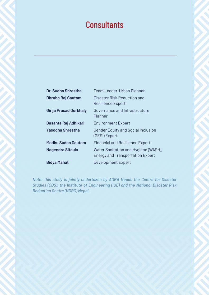
Consultants
Dr. Sudha Shrestha Team Leader-Urban Planner
Dhruba Raj Gautam Disaster Risk Reduction and Resilience Expert
Girija Prasad Gorkhaly Governance and Infrastructure Planner
Basanta Raj Adhikari Environment Expert
Yasodha Shrestha Gender Equity and Social Inclusion (GESI) Expert
Madhu Sudan Gautam Financial and Resilience Expert
Nagendra Sitaula Water Sanitation and Hygiene (WASH), Energy and Transportation Expert
Bidya Mahat Development Expert
Note: this study is jointly undertaken by ADRA Nepal, the Centre for Disaster Studies (CDS), the Institute of Engineering (IOE) and the National Disaster Risk Reduction Centre (NDRC) Nepal.
III
AcknowledgementsWe would like to express our gratitude to the Department for International Development (DFID) Nepal, who provided us (ADRA Nepal, CDS, IOE, and NDRC) with an opportunity to do the scoping study for the ‘Nepal Urban Resilience Program’. Special thanks go to Ms. Eleanor Bainbridge (Infrastructure Advisor, DFID), for her continuous, generous support and suggestions; Ms. Corona Ranjit (DFID), for her support in the initial phase, and to Mr. Sumit Dugar (DFID), for his continuous support.
We would like to thank all the government officials from MOUD, MOFALD, DUDBC, MoHA, DMG, DWIDM, and DOLIDAR (a key to abbreviations is provided below) for providing us with their valuable time and fruitful information. Similarly, we would like to express our thanks to development partners, INGOs and NGOs such as UNDP, JICA, EU, ADRA, LWR, DCA, WVI, NDRC and Practical Action for their valuable time and useful information for the study.
Thanks go to all respondents of our questionnaire, participants of the workshops and those who provided us with suggestions. We express our thanks to the Mayors, Deputy Mayors, and advisors of mayors who gave their valuable time answering our questions. Thanks also go to the research assistants who helped the team in collecting data. Finally, we offer thanks personally to those who directly or indirectly supported us in contributing to the success of this scoping study.
Scoping Study Team
IV
Executive SummaryUrban areas are growing rapidly around the globe. It is estimated that 54% of the world’s population currently lives in urban areas and this is predicted to increase to 66% by 20501. Rapidly-growing urban areas characterized by populations with low- and middle-income are increasingly affected by damage caused by adverse climatic conditions and are more susceptible to natural disasters owing to the circumstances of their accommodation2.
The purpose of the scoping study scoping study was to inform the NURP, prior to the project being up and running. The scoping study had three key objectives, which are outlined below and will presented in detail in this report:
• To identify which urban resilience themes/approaches that the government ministries and donor agencies are active in. This will explore what their work consists of, and where they are focused geographically
• To define a clear methodology for selecting focus areas for the Nepal Urban Resilience Project (NURP) using factors such as population size, growth rate, prevalence of informal settlements, urban poverty, climatic and environmental risks, existing donor initiatives, local government dynamics, and strategic regional connections
• To examine four urban municipalities (sampled across the country) in detail to unpack how land- use planning and infrastructure is currently being implemented and to scope possible entry points through which risk-sensitive and resilient urban development can be built into these processes.
The pace of urbanization is accelerating also in Nepal. Up to 2011 there were only 58 municipalities, but within four years, in 2014 it had increased to 190 municipalities, and in 2015 to 217, and 293 in 2017. The National Urban Development Strategy (NUDS), Ministry of Urban Development (MOUD), 2017) provides a framework to implement urban resilience projects in Nepal. This strategy focuses on physical, environmental, social, economic, and institutional resilience. Resilience is enhanced through the internalization of resilience perspectives concerning land-use regulations, building codes and by-laws; and by enhancing awareness and preparedness to deal with disaster risks and vulnerabilities at all levels of government. Similarly, the National Urban Policy 2007, emphasizes strategies for balanced urban development of nations to make urban areas clean and prosperous. It also proposes the preparation of Disaster Management Plans (DMPs) by all local bodies.
The development partners’ support in the NUDS implementation focuses on enhancing the capacity of the different levels of governments, and different phases of Disaster Risk Reduction (DRR). In addition, at the municipality level, DRR plans (e.g. Local Disaster & Climate Resilience Plans (LDCRPs) were also formed and efforts were made to mainstream priorities into regular development plans. Similarly, building code revisions and their incorporation into the building permit system were notable initiatives by the government with the development partners. There are other projects that have been implemented under the ‘Urban Resilience Programme’ in the past. Most of these programmes involved software components, and very few had physical infrastructure development components in the urban DRR projects. Recently, the Asian Development Bank (ADB) approved a loan to the government of Nepal to improve the delivery of urban services and infrastructure, aiming to help the
1 National Urban Development Strategy (NUDS 2017), MoUD, GoN.
2 World Disaster Report, 2016. Available at http://www.ifrc.org/Global/Documents/Secretariat/201610/
WDR%202016-FINAL_web.pdf. Accessed 12 April 2018.

V
development of more-sustainable, inclusive, and resilient systems.
Although ‘resilience’ means there is the capability to respond and recover from disasters quickly and with minimum loss, or the ability to return to at least the original state for minimum cost and quickly, the present project also considers the preparedness and resistance to disasters. It also considers the governance and awareness of people involved.
Although the National Building Code and Building Byelaws are mandatory in the Nepalese municipalities, the majority of people living in their rural areas are less aware of their importance. After the 2015 earthquake, municipalities became more attentive to implementing the National Building Code (NBC).
The recently declared municipalities lack proper resources. Hence, there are many challenges in providing appropriate services during disaster events. This has meant that the Urban Water Sanitation and Hygiene (WASH) systems are at great risk during disasters due to lack of sanitary landfill sites. The aim is to improve health by reducing or removing instances of water and vector-borne diseases during disasters, which means that resilience in urban WASH systems – health, promptness, idleness and originality, are thus a critical factor to be considered as part of a resilient WASH intervention. There are some initiatives for sanitary landfill sites for Solid Waste Management (SWM). However, most of the Nepalese municipalities have not progressed sufficiently in this regard.
The resilience of an urban area is closely dependent on its infrastructure. Transportation and energy (electricity) are vital components of urban resilience. In the plain areas of Nepal, there is better access to roads suitable for motor vehicles, even if many of them are not metalled, and are simply compacted earth. But in mountainous regions, cities are situated on ridges or in small valleys, making vehicular access and transportation difficult.
Urban energy systems are characterized by specific challenges and opportunities. Not all municipalities have been connected to the national electricity grid; however, biogas and solar power are also in use.
In the new constitution of Nepal (2015) there are three tiers of government - Federal, Provincial and Local. Recently, also local and provincial government representatives have been elected and started their work. As the constitution requires, currently elected bodies to have considerable representation of female, indigenous and deprived communities, in order to make the resilience more gender-friendly and inclusive. This is important in protecting women, children, senior citizens, and people living with disabilities (PLWD), Dalits (occupational casts) and other socially marginalized or disadvantaged groups from the negative effects of disasters of any kind. During the post-2015 earthquake period, the survivors had to live in tents or temporary settlements and domestic violence increased during that period. Municipal officials seemed aware of who was vulnerable, but to date, most municipalities have carried out no vulnerability assessments, and there is scant vulnerability data. Also, municipalities do not have systematic documentation of the indigenous coping mechanisms – how local people deal with problems through their own established practices. They also do not have separate sections or operational units that can deal with disasters and Gender Equity and Social Inclusion (GESI).
Among the many relevant Urban Resilience Indicators (URIs) to choose from for the municipalities implementing the Nepal Urban Resilience Project (NURP), only a few were selected for the present
VI
study owing to the three-month time constraint. Only such indicators were selected so that data related to them could be collected from already available published reports or could be collected through simple enquiries and surveys.
Indicators were broadly taken from aspects such as Urban planning, Environment, Hazards, Infrastructure, Social structure and economy, Municipal capacity, Demography and Existence of development partners. The indicators were given weightings, developed for the selection of seven municipalities for implementation of the Nepal Urban Resilient Project, and were tested in four sample municipalities (see Annexes 5a and 5b).◗
ACKNOWLEDGEMENTS III
EXECUTIVE SUMMARY IV
ABBREVIATIONS IX
CHAPTER 1: INTRODUCTION 1
1.1 BACKGROUND 1
URBAN RESILIENCE 3
1.2.1 URBANIZATION IN NEPAL 3
1.2.2 URBAN RESILIENCE 6
1.2.3 FACTORS OF URBAN RESILIENCE 7
1.3 RATIONALE 8
1.4 OBJECTIVES 9
CHAPTER 2: STUDY METHODS 10
CHAPTER 3: POLICIES AND GOVERNANCE 11
3.1 POLICIES 11
3.2 GOVERNANCE 12
CHAPTER 4 : GOVERNMENT AND DEVELOPMENT PARTNERS 14
4.1 GOVERNMENT INITIATIVES 14
4.2 DEVELOPMENT PARTNER’S SUPPORT 14
CHAPTER 5: CRITERIA FOR THE SELECTION OF MUNICIPALITIES FOR NURP 17
CHAPTER 6: URBAN RESILIENCE, CONTEXTUAL ANALYSIS 25
6.1 OVERALL CONTEXT 25
6.2 ENVIRONMENTAL RISK 27
6.3 GENDER EQUALITY AND SOCIAL INCLUSION 32
6.3.1 MUNICIPALITY LEVEL INFRASTRUCTURE AND SERVICES 34
6.3.2 EXISTENCE OF GESI INDICATORS 35
6.4 DRR UNDERSTANDING AND DATA AVAILABILITY 37
6.5 COORDINATION: MUNICIPALITY AND THE EXTERNAL ACTORS 39
6.6 INDIGENOUS COPING MECHANISMS 41
6.7 PLANNING: INFRASTRUCTURES AND SERVICES 41
TABLE OF CONTENTS
CHAPTER 7 : CONCLUSION 56
7.1 CONCLUSION 56
7.2 RECOMMENDATIONS FOR ‘ENTRY POINTS’ TO NURP 56
LIST OF TABLES
Table 1: Classification of Urban Municipalities as per Local Government Operation Act 2017
3
Table 2: The keywords mostly used in urban resilience literatures 7
Table 3: Support to municipality and key stakeholders 15
Table 4: Indicators from NUDS 2017 17
Table 5: Criteria for the selection of NURP implementation municipalites 20
Table 6: Population and Population Growth rate in the four municipalities studied 25
Table 7: Types of hazards in the four studied municipalities (based on field surveys, 2017)
29
TABLE 7b: Initiatives and available data in the studied municipalities (based on field surveys conducted, 2017)
31
Table 8: External Actors working with the four municipalities under study in DRR 40
Table 9: Comparative table of the various plans and the existence/ status for the four studied municipalities
42
Table 10: Road networks 46
Table 11: Comparative status of WASH, power and transportation infrastructure of the four studied municipalities
49
IX
Abbreviations ADB: Asian Development Bank
ADRA: Adventist Development and Relief Agency
CARE: Cooperative for Assistance and Relief Everywhere
CBDRM: Community Based Disaster Risk Management
CCA: Climate Change Adaptation
CCS: Centre for Disaster Management
CDO: Chief District Officer
CDS: Centre for Disaster Studies
CEDAW: Convention on the Elimination of all Forms of Discrimination Against Women
CHS: Core Humanitarian Standards
CPiE: Child Protection in Emergency
DAO: Decentralized Autonomous Organization
DEOC: District Emergency Operation Centre
DFID: The Department for International Development
DHM: Department of Hydrology and Meteorology
DIMS: Disaster Information Management System
DM: Disaster Management
DMG: Department of Mines and Geology
DOLIDAR: Department of Local Infrastructure Development and Agriculture Road
DRMP: Disaster Risk Management Plan
DRR: Disaster Risk Reduction
DRRMA: Disaster Risk Reduction and Management Act
DUDBC: Department of Urban Development and Building Construction
DWIDM: Department of Water Induced Disaster Management
EFLG: Environment Friendly Local Government
EiE: Education in Emergency
EOC: Emergency Operation Centre
EQ: Earthquake
EU: European Union
FSET: Food share Employment and Training
GESI: Gender Equity and Social Inclusion
GFDRR: Global Facility for Disaster Risk Reduction
GLOF: Glacial Lake Outburst Flood
HDI: Human Development Index
INGOs: International Non-Governmental Organization
X
IOE: Institute of Engineering
IUDP: Integrated Urban Development Project
JICA: Japanese International Cooperation agency
KVDA: Kathmandu Valley Development Authority
LAPA: Local Adaptation Plan of Action
LDCRC: Local Disaster & Climate Resilience Committee
LDCRP: Local Disaster & Climate Resilience Plan
LSGA: Local Self Governance Act 1999
LURP: Local Urban Resilience Plan
LWR: Lutheran World Relief
MEOC: Municipality Emergency Operation Centre
MEPRP: Municipality Emergency Preparedness Response Plan,
MoFALD: Ministry of Federal Affairs and Local Development
MOHA: Ministry of Home Affairs
MOUD: Ministry of Urban Development
NAPA: National Adaptation Plan of Action
NBC: National Building Code
NGO: Non-Government Organisation
NRA: National Reconstruction Authority
NRCS: Nepal Red Cross Society
NSDRM: National Strategy for Disaster Risk Management
NSRLC: National Strategy for Resilient Local Communities
NUDS: National Urban Development Strategy 2017
NURP: Nepal Urban Resilience Project
ODF: Open Defecation Free
OXFAM: Oxford Committee for Famine Relief
PLWD: Persons Living with Disabilities
RCC: Reinforced Cement Concrete
RDC: Reception Departure Centre
SAR: Search and Rescue
SDGs: Sustainable Development Goals
SFDRR: Sendai Framework for Disaster Risk Reduction
SOP: Standard Operating Guideline
SWM: Solid Waste Management
TU: Tribhuvan University
XI
UN: United Nations
UNDP: United Nations Development Program
UNICEF: United Nations International Children’s Emergency Fund
UNSCR: United Nations Security Council Resolution
USAID: The United States Agency for International Development
VCA: Vulnerability and Capacity Assessment
WASH: Water Sanitation and Hygiene
WB: World Bank
WFP: World Food Program
WV: World Vision
XII
Figure 1: Map of 293 municipalities in Nepal 2
Figure 2: Male and female population percentage of four municipalities is given bellow. 25
Figure 3: Male and female population percentage of four municipalities is given bellow 26
Figure 4: Road networks 47
Figure 5: Access to toilets 48
Figure 6: Comparative study of cooking energy in four municipalities 52
Figure 7: Energy for light 53
Figure 8: Access to communication of four municipalities 54
LIST OF FIGURES
CHAPTER 1: Introduction
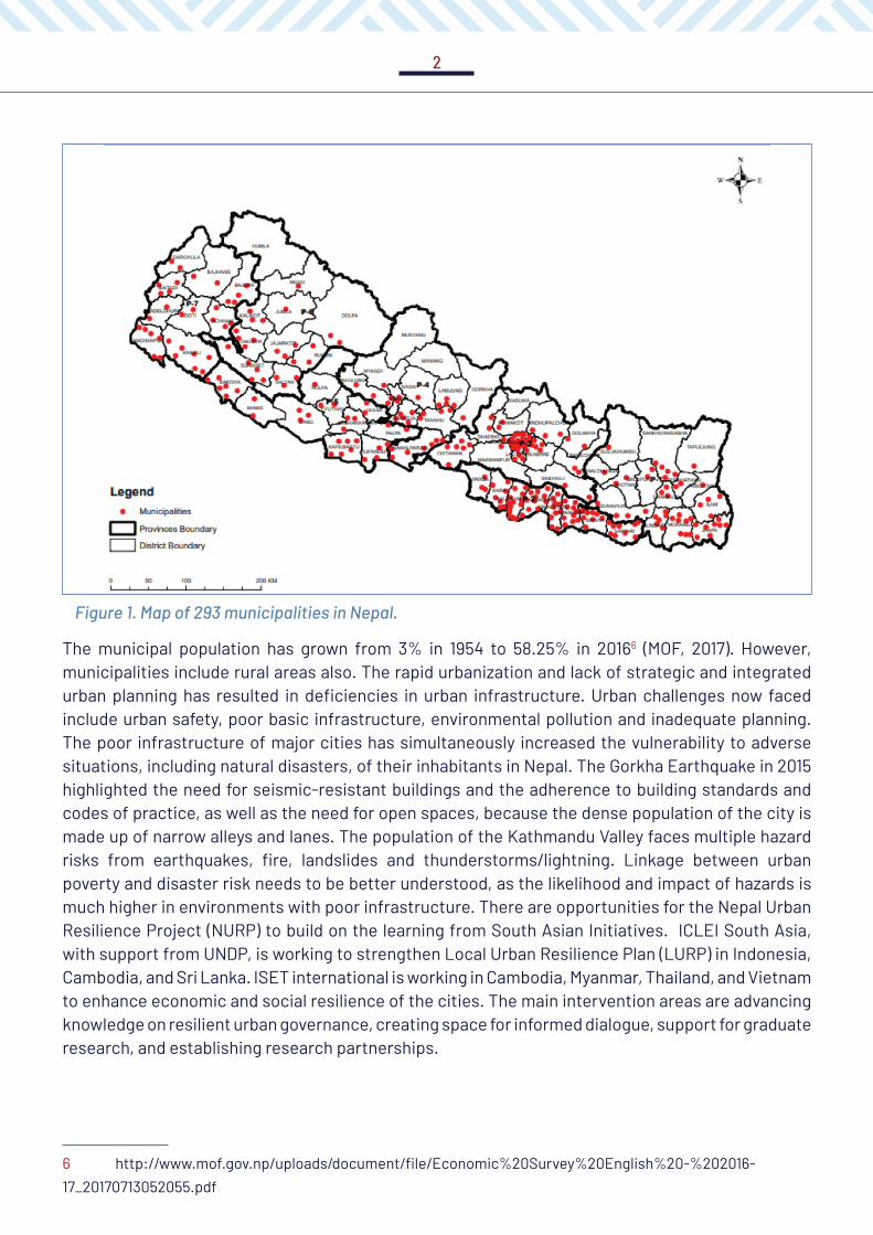
1.1 BackgroundUrban areas are expanding rapidly around the globe. It is estimated that 54% of the world’s population currently live in urban areas, and this is predicted to increase to 66% by 20503. Along with an exponential growth in the global population, urban areas are also expanding, and so also are the challenges associated with densely populated urban areas. Rapidly-growing urban areas in countries with typically low- and middle-income families are increasingly affected by damage caused by adverse climatic conditions4. The Global Facility for Disaster Risk Reduction (GFDRR) reported that adverse climatic conditions caused annual property and livestock losses is valued at approximately US$150 200 billion. The World Disaster Report (2016) mentions “increasing urban populations, environmental degradation, poverty and disease, which are compounding seasonal hazards such as droughts and floods to create situations of chronic adversity”. The report emphasized the need to address Disaster Risk Reduction (DRR) issues in urban areas.
Addressing disasters in urban areas is often complex because of high population densities, accessibility issues, and lack of open spaces and high market-pressures. Urban DRR is emerging as a major concern, because the capacity to cope with disasters has not kept pace with the rapid rate of urbanization globally, especially in low- and middle-income countries. Urban dwellers, particularly low-income groups in many developing countries, are particularly vulnerable to disasters, primarily due to inadequate disaster preparedness planning and lack of response facilities. The gap between infrastructure needs and supply in urban areas in developing countries like Nepal is widening. Although government policies and plans have started to consider disasters, they are not yet effective in enhancing resilience to disasters. Rapidly urbanizing cities require a focused approach to interventions concerning urban Disaster Resilience. As a rapidly urbanizing country, Nepal also needs to develop effective approaches on urban resilience. This is of great significance to Nepal as 31 of its municipalities were affected by the 2015 Gorkha earthquake (whose epicentre was far from any major municipalities), amounting to losses valued at approximately US$ 7 billion, categorized under housing and human settlement5. The World Disaster Report (2016) also pointed out a lack of clarity on dealing with response to natural disasters in urban areas in Nepal.
Nepal is one of the fastest urbanizing countries in the world, with an urbanization growth rate of 3% for the period from 1990 to 2014 (UN DESA, 2014). The number of municipalities has also been increasing rapidly, from 58 municipalities in 2011 to 190 municipalities in 2014, and to 217 in 2015, and 293 in 2017 (Figure 1). The population residing in urban municipalities has now risen to more than 60%. The main reasons for a growing urban population are due to a) natural growth of the urban population, b) rural to urban migration; and c) expanding the physical extent of urban areas by government declaration. The establishment of the Ministry of Urban Development in 2012 and the development of the National Urban Development Strategy (NUDS 2017) indicate the country’s focus on urban governance and legislation. With the new federal structure in place, the local government institutions (municipalities) are increasingly emphasizing and recognizing the need for sustainable and resilient urban planning.
3 http://www.un.org/en/development/desa/news/population/world-urbanization-prospects-2014.html
4 World Disaster Report, 2016
5 Post Disaster Need Assessment (PDNA), 2015
2
Figure 1. Map of 293 municipalities in Nepal.
The municipal population has grown from 3% in 1954 to 58.25% in 20166 (MOF, 2017). However, municipalities include rural areas also. The rapid urbanization and lack of strategic and integrated urban planning has resulted in deficiencies in urban infrastructure. Urban challenges now faced include urban safety, poor basic infrastructure, environmental pollution and inadequate planning. The poor infrastructure of major cities has simultaneously increased the vulnerability to adverse situations, including natural disasters, of their inhabitants in Nepal. The Gorkha Earthquake in 2015 highlighted the need for seismic-resistant buildings and the adherence to building standards and codes of practice, as well as the need for open spaces, because the dense population of the city is made up of narrow alleys and lanes. The population of the Kathmandu Valley faces multiple hazard risks from earthquakes, fire, landslides and thunderstorms/lightning. Linkage between urban poverty and disaster risk needs to be better understood, as the likelihood and impact of hazards is much higher in environments with poor infrastructure. There are opportunities for the Nepal Urban Resilience Project (NURP) to build on the learning from South Asian Initiatives. ICLEI South Asia, with support from UNDP, is working to strengthen Local Urban Resilience Plan (LURP) in Indonesia, Cambodia, and Sri Lanka. ISET international is working in Cambodia, Myanmar, Thailand, and Vietnam to enhance economic and social resilience of the cities. The main intervention areas are advancing knowledge on resilient urban governance, creating space for informed dialogue, support for graduate research, and establishing research partnerships.
6 http://www.mof.gov.np/uploads/document/file/Economic%20Survey%20English%20-%202016-
17_20170713052055.pdf
Urban Resilience
1.2.1 Urbanization in NepalA formal definition of ‘urban’ in Nepal was documented from its first census in 1961. There were then 16 municipalities, which had a minimum population of 5000, with facilities including high schools, colleges, judicial and administrative offices, communication facilities, bazaars (markets), mills, and factories (Pradhan, 2003). The Nagar Panchayat Act 1962, classified areas with more than 10,000 population as ‘municipal’. The Municipal Act 1992, and the Local Self Governance Act (LSGA) 1999, redefined the definition of urban areas. The hierarchical classification of municipalities according to the LSGA 1999 is:
• Municipality
• Sub-Metropolitan city
• Metropolitan city
The urban population is calculated as the inhabitants residing in the designated municipal areas. Population size has been taken as the principal criteria in the declaration of urban areas in Nepal since 1961. Municipalities can therefore also include rural areas.
293 urban municipalities contain 60% of the Nepalese population. To address the ever-increasing risks in rapidly urbanizing areas in Nepal, organizations have recently begun to take on the challenge of designing Disaster Risk-Reduction (DRR) measures and management interventions in the urban context. Although some of the minimum characteristics are relevant for the urban context, it is uncertain how accurately they reflect the components of a disaster resilient community.
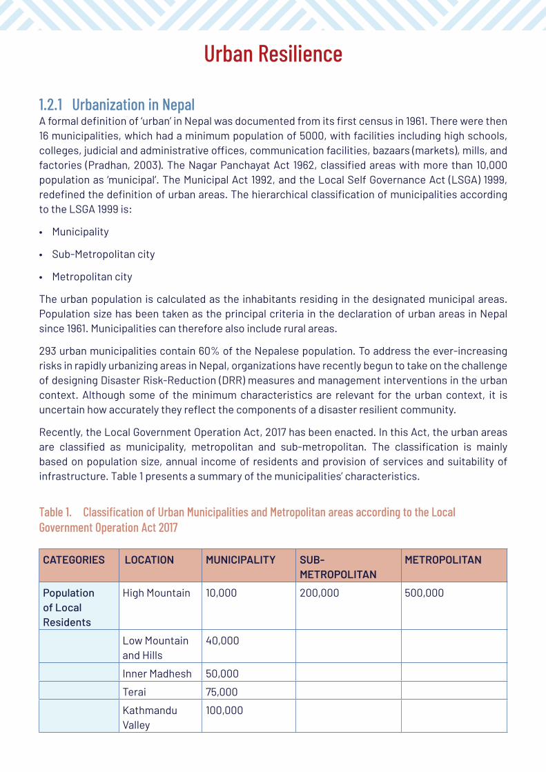
Recently, the Local Government Operation Act, 2017 has been enacted. In this Act, the urban areas are classified as municipality, metropolitan and sub-metropolitan. The classification is mainly based on population size, annual income of residents and provision of services and suitability of infrastructure. Table 1 presents a summary of the municipalities’ characteristics.
Table 1. Classification of Urban Municipalities and Metropolitan areas according to the Local Government Operation Act 2017
CATEGORIES LOCATION MUNICIPALITY SUB-METROPOLITAN
METROPOLITAN
Population of Local Residents
High Mountain 10,000 200,000 500,000
Low Mountain and Hills
40,000
Inner Madhesh 50,000
Terai 75,000
Kathmandu Valley
100,000
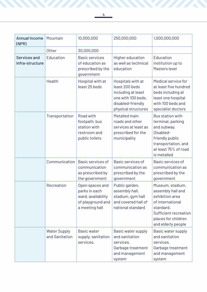
4
Annual Income (NPR)
Mountain 10,000,000 250,000,000 1,000,000,000
Other 30,000,000
Services and Infra-structure
Education Basic services of education as prescribed by the government
Higher education as well as technical education
Education institution up to Masters level
Health Hospital with at least 25 beds
Hospitals with at least 200 beds including at least one with 100 beds, disabled-friendly physical structures
Medical service for at least five hundred beds including at least one hospital with 100 beds and specialist doctors
Transportation Road with footpath, bus station with restroom and public toilets
Metalled main roads and other services at least as prescribed for the municipality
Bus station with terminal, parking and subway. Disabled-friendly public transportation, and at least 75% of road is metalled
Communication Basic services of communication as prescribed by the government
Basic services of communication as prescribed by the government
Basic services of communication as prescribed by the government
Recreation Open spaces and parks in each ward, availability of playground and a meeting hall
Public garden, assembly hall, stadium, gym hall and covered hall of national standard
Museum, stadium, assembly hall and exhibition area of international standard. Sufficient recreation places for children and elderly people
Water Supply and Sanitation
Basic water supply, sanitation services.
Basic water supply and sanitation services. Garbage treatment and management system
Basic water supply and sanitation services. Garbage treatment and management system
5
Others Market place, animal slaughter house, human corpse disposal place
Market place, animal slaughter houses, human corpses disposal place. Hotel, motel and resorts of tourism standards. Disable friendly and physically accessible infrastructures
Shopping mall, vegetable and fruit market, hotels of international standards. Urban greenery and scenic beauty
The Urban Policy, 2007 published by MOUD also gave the criteria for the designation of urban areas in Nepal, where density, contiguity and occupational structure were key aspects. But the Local Government Operation Act 2017 does not consider those relevant and necessary characteristics. In designating municipalities, only population size, municipal income and infrastructure and services were taken in to account (see Table 1). For population size, rural areas were agglomerated for infrastructure and services, but the Act does not consider the per capita income nor unit of area relevant to population density. Similarly, for income, it considers not per capita income but only the total. Thus, newly designated municipalities were dominated by rural areas with agricultural land as well as forests. In a survey, almost all newly designated municipalities requested DUDBC for agriculture, irrigation and cold storage.
It would not have been possible to establish the present 293 municipalities if they followed the National Urban Policy 2007. However, because of drastic changes in urban circumstances in Nepal, there are ample opportunities to redefine ‘urban areas’, incorporating urban farming for food safety and security, as well as urban forest yielding forestry products. These will help to maintain urban ecological balance of municipalities. It also gives opportunity to conserve agricultural land and forests so that municipalities are also able to produce food for people directly.
6
1.2.2 Urban Resilience‘Urban Resilience’ is what helps cities adapt and transform physically and socially in response to stresses.. Urban resilience is not a new concept; it has been debated and discussed over several decades across scientific disciplines, including urban planning. Some of the definitions of Urban Resilience are given below with key descriptors are shown in Table 2:
National Urban Development Strategy (NUDS 2017) of Nepal7 - “Resilience refers to both physical and social resilience so that cities are safer and adaptable to changes, both environmental and economic. The major focus of the strategy is on physical, social, economic and institutional resiliency, that is pivotal for mitigating short or long-term vulnerability resulting from disaster or the regional/global impacts of climate change”.
DFID (2011a, 6): Disaster resilience – “the ability of countries, communities and households to manage change, by maintaining or transforming living standards in the face of shocks or stresses – such as earthquakes, drought or violent conflict – without compromising their long-term prospects”.
100 Resilient Cities8 has defined Urban Resilience as: “The capacity of individuals, communities, institutions, businesses, and systems within a city to survive, adapt and grow no matter what kinds of chronic stresses and acute shocks they experience.”
According to The Resilient Europe9: “Urban resilience is the capacity of urban systems, communities, individuals, organizations and businesses to recover maintain their function and thrive in the aftermath of a shock or a stress, regardless its impact, frequency or magnitude.”
Resilience as defined by the Sendai Framework is the ability of a system, community or society exposed to hazards to resist, absorb, accommodate, adapt to, transform and recover from the effects of a hazard in a timely and efficient manner, including through the preservation and restoration of its essential basic structures and functions through risk management10.
NSRUC MoFALD 201611: The word means the capacity to ‘bounce back’ from a disaster and ‘spring forward’. The resilience of a natural ecosystem is its ability to absorb disturbances and change while maintaining the same structural functions and providing the same basic services. Borrowing from both ecology and sociology, the NSUCR frames resilience as the capacity of a system, institution, or agent to maintain its core purpose and integrity in the face of dramatically changed circumstances.
According to ‘100 Resilient Cities’, building urban resilience requires consideration of a city holistically: understanding the systems that operate in the city and the interdependencies and risks they may face. By strengthening the underlying fabric of a city and better understanding the potential shocks and stresses it may face, a city can improve its development trajectory and the well-being of its citizens. It highlights the resilient capacities of cities against the chronic stresses and acute shocks,
7 National Urban Development Strategy (NUDS 2017), MoUD, GoN.
8 100 Resilient Cities. Retrieved from http://www.100resilientcities.org/resources/#section-1
9 Frantzeskaki, N. (2016) Urban Resilience: A concept for co-creating cities of the future. Retrieved from
http://urbact.eu/file/13255/download?token=X3T8_ta0. Accessed 13 April 2018.
10 https://www.unisdr.org/we/inform/terminology. Accessed 13 April 2018. 8 National Urban Policy-2007,
DUDBC Government of Nepal
11 National Strategy for Resilient Urban Communities MoFALD 2016

7
but the definition does not explicitly include the ability of a city to recover from crisis events.
‘Resilient Europe’ explains that urban resilience is a transformative concept that requires new planning approaches that address resilience qualities such as redundancy and flexibility that are contradictory to the efficiency (that is a basic principle to new public management approach that many cities follow). It also highlights the importance of the capacity of the urban system regardless of the impact, frequency or magnitude of hazard events and shocks.
Table 2. The keywords used mostly in urban resilience literature
Absorb The amount of disturbance municipalities can absorb
Recover The ability to return at least to previous conditions after the damage resulting from a disaster
Thrive To prosper in the aftermath of a disaster and be better prepared for future events (“futureproofing”)
Survive, adapt and grow To overcome the consequences of a disaster and learn from the experience, similar to ‘thrive’
1.2.3 Factors of Urban ResilienceThe literature indicates three mechanisms or pathways to achieving a resilient state: persistence, transition, and transformation. Most of the definitions focus on persistence in creating a the system that can withstand disturbances. Other definitions refer to incremental change, that is, adaptation and transition. Maintaining the basic functions in the time of a disaster/emergency is a key aim. The degree of urban resilience depends on several factors. Some of the factors include the availability of funds, early warning systems, hazard models, availability of scientific data, and the capacities of local, provincial and federal governments. Of these factors, the availability of Disaster Risk-Reduction (DRR) funds plays an important role in fostering resilience. There are several models of DRR financing. The following three models of DRR financing can be used in practice at a city level:
• DRR funds used as a special source for targeted DRR needs
• DRR funds at the municipality level to be used at the time of disaster emergency
• DRR funds integrated into development planning and management.
The first model allocates the funds for the targeted prioritised DRR needs. In Nepal, the Prime Minister’s Disaster Relief Fund can be taken as an example. According to the new Disaster Risk Reduction and Management Act 2017, local governments are required to provide a budgetary allocation for a Disaster Managaement (DM) fund. The four sample municipalities considered in this study made an allocation for a DM fund for the fiscal year 2017/18. However, there are no clear guidelines for the use of the fund. The local government is required to develop a guideline for the utilization of the fund. The second model aims to establish the fund at the local level that can be utilised in the time of an emergency. Whereas the third model of DRR financing is yet to be practiced in Nepal. It aims to integrate DRR into regular development planning and management. The sources of the fund in DRR could be from tax revenue, community co-financing, grants and loans. Enhancing disaster resilience
8
would require several financial instruments. Disaster risk insurance is one of the effective financial instruments to reduce the risk of loss due to a natural disaster. The new local government operation act 2017 of Nepal has clearly identified ‘Climate Change and Disaster Management’ as one of the bases of local level planning, prioritisation, and budget allocation. It aimed to contribute to climate and disaster resilient communities in the municipalities. The Ministry of Home Affairs (MOHA) is preparing a “National DRR Policy & Strategic Action Plan: 2017-2030”. The draft policy12 is available for input and feedback. The proposed action plan has made provisions for disaster risk insurance for all assets at risk (including livestock). Insurance of urban infrastructure against disaster is one of the important resilience factors13 which play an important role in building physical and economic resilience of urban areas. A city needs to establish an insurance mechanism to improve the economic resilience of urban poor.
While urban resilience initiatives contribute to sustainable development, it is important to have a proper resilience framework for their effectiveness. The Sustainable Development Goals (SDGs) and Sendai Framework on Disaster Risk Reduction (SFDRR) provide the broader international framework of resilience.
1.3 RationaleNepal is subject to a wide range of disaster risks and environmental impacts, including both earthquakes and climate-related hazards such as floods, drought, landslides, erratic rainfall, thunderstorms and diseases. Disasters cost the government about six percent of its annual development expenditure per year14. These impacts are expected to increase significantly due to climate change. The combination of pressure on land use, unplanned urbanisation often on marginal land, and poor infrastructure and services makes urban centers unsafe, particularly for the poorest and most vulnerable members of society.
At present there are 293 urban areas of which six are metropolitan, 12 sub-metropolitan, and 275 are municipalities in Nepal. The decentralisation of power requires local authorities to implement policies, including DRR. Policies focusing on DRR, which have previously not been implemented, can now be undertaken by local governments. The newly elected local authorities can mainstream DRR policies into the planning process and budget system. The implementation of these action plans will be more effective at the local level. However, there is a considerable deficit in the capacity of local government for DRR planning, risk assessment and risk-sensitive budgeting. The present scoping study identifies the entry points for the Nepal Urban Resilience Project (NURP). The NURP will be implemented in urban municipalities. The number of municipalities investigated in this study were identified in consultation with the government and the project team. This will be a pilot project on urban resilience by the government of Nepal. Findings from this project will help local government authorities strengthen their ability to implement disaster-resilient urban building, planning, infrastructure and services. It will also support national government to develop, implement and monitor policy on urban disaster resilience.
12 http://drrportal.gov.np/document/documentdetail/1186
13 Shaw, R. et al. (2009). Climate disaster resilience: focus on coastal urban cities in Asia. Asian Journal of
Environment and Disaster Management, 1, 101-116.
14 14
9
1.4 Objectives The objectives of the scoping study are as follows:
• To identify which urban resilience themes/approaches that the government ministries and donor agencies are active in. This will explore what their work consists of, and where they are focused geographically.
• To define a clear methodology for selecting municipalities for the Nepal Urban Resilience Project (NURP) using factors such as population size, growth rate, prevalence of informal settlements, urban poverty, climatic and environmental risks, existing donor initiatives, local government dynamics, and strategic regional connections. One very important parameter is local government dynamics, which is the function of active public participation in municipal decisions; partition composition of the municipal board; level, knowledge and political connection/alignment with the higher political authorities and so on. But these were very difficult to survey and evaluate extensively during the three month inception period of the study. ◗
CHAPTER 2: Study Methods
The methodology and tools applied in the study were varied in approach, to meet the different study objectives. The study team members carried out a secondary review of the documents (literature on resilience, policies, reports, best practices, etc.) and conducted face-to-face consultations with the government, donors and non-government agencies to map out their initiatives. This specifically assessed the thematic areas in which the agencies are active. A half-day group consultation workshop was also organised in Kathmandu on October 16, 2017. Representatives from the government, donor agencies and INGOs participated in the meeting. The main objectives of the meeting were:
• to share the preliminary findings of the study,
• to understand more about engagement of agencies, and
• to solicit input and feedback on the preliminary findings from participants.
Another major part of this study was to scope out possible useful ways of influencing policy (‘entry points’) by examining the land-use plan and infrastructure services currently being implemented. For this 4 sampled municipalities (see Annex 1)15 across the country were identified based on various criteria (see Annex 4, of the inception report). The main parameters were population size, geographic location, indigenous population majority, development potential, disaster potential, per capita (financial) effect of the 2015 earthquake, and district Human Development Index, among others. The sampled municipalities were Chandannath of Jumla, (Karnali Province), Chautara Sanga Chok Gadhi of Sindhupalchok (Province 3), Gaur of Saptari (Province 2) and Dhanngadi of Kailai (Province 7). A detailed questionnaire (see Annex 2)16 was prepared to collect information on land-use planning, infrastructure, and disaster preparedness of the municipalities. To collect detailed information, four research assistants, who had an educational background in engineering and disaster studies were deployed in the sampled municipalities. They stayed for three weeks in the sampled municipalities to collect detail information. Each of the experts involved in compiling this study also visited municipalities and carried out consultation with the municipal authorities and representatives. The detailed information (see Annex 3)17 was analyzed to understand the urban context in relation to its resilience and to identify possible entry points.
15 Profile of four municipalities.
16 Included in separate file
17 Included in separate file
CHAPTER 3: Policies and Governance
3.1 PoliciesThe Government of Nepal is well prepared with policies, acts, strategies, guidelines, and bylaws that provide the frameworks of urban planning, infrastructure services and Disaster Risk-Reduction (DRR). Key policy provisions that are relevant to, and helpful in, facilitating urban resilience are discussed in this section.
National PoliciesNational Calamities Act 1982: First Act to highlight and turn focus on protecting lives and properties against disasters. It was also the basis for the provision of relief operations. Through this Act, Nepal has provisioned 5% of the annual budget to DRR.
10th Development Plan (2002-2007): This inaugurated the emphasis that was placed on the need for risk assessment and DRR was recognized. The 10th Development Plan also envisaged the importance for GIS mapping to identify various vulnerable areas.
National Urban Policy (2007): This policy emphasized balanced urban development. It outlined urban designation parameters and sustainable balance urban development systems.
11th, 12th and 13th Three-Year Interim Plans (2007-2015): The plans provided a shift of focus from disaster response to disaster preparedness. The objectives were to mainstream DRR into the development process and to recognize the need for better coordination between institutions. The Interim Plans were at the central level of the government and they provided guidelines, but did not achieve significant progress at the local level.
Inclusive Cities: Resilient Communities (Nepal’s National Report to The Third United Nation Conference on Housing and Sustainable Urban Development Habitat III 2016): This document focuses on urban issues, and the urban economy in Nepal. It deals with urban housing and its affordability, the provision of adequate urban infrastructure and services and employment opportunities, safety and security, and protection of Environment.
National Urban Development Strategy (NUDS), 2017: The strategy guides urban development to achieve desirable conditions in infrastructure, economy, finance and environment. The NUDS aims to promote multi-hazard approaches, emphasizes the need for better preparedness of the government, and raising community-awareness in DRR.
National Strategy for Resilient Local Communities, 2017: This provides the guidelines for the development of resilient local communities. In part 3, the strategy discusses on matters related to resilient urban communities. It aims to reduce the risk exposure, to build resilient structures, strengthen ecological systems, and build capacity for all stakeholders, and strengthen local level institutions.
Disaster Risk Reduction [DRR] and Management Act, 2017: The enactment of this act was a milestone in achieving DRR preparedness, response and mainstreaming into development works of Nepal. It clearly identified the roles and responsibilities of central, provincial, and local government in DRR. In addition, it seeks to encourage support from NGOs, local organizations, community, volunteers, private sector and individuals for disaster management. It has provisions for the DM fund in all the three tiers of government (central, provincial and local).

12
Local Government Operation Act, 2017: In Sub-section 2 of Section 8, provisions are made for the roles, responsibilities and rights of local government. According to this act, disaster management is one the main tasks of the municipality. The municipality is responsible for implementation, monitoring and evaluation of the DRR act (see above), policies, and plans. It stresses on DRR preparedness, establishment of Emergency Operation Centres (EOCs), risk and vulnerability mapping, provision of disaster funds, search and rescue, recovery and reconstruction, and the Community-Based Disaster-Risk Management (CBDRM) programme. It states that each municipality shall coordinate with civil society, local organizations, NGOs and the private sector for local disaster-risk management.
Global Policies and Agreements:Sendai Framework for Disaster Risk Reduction, 2015-2030: The SFDRR is a voluntary agreement recognizing the need for DRR. It shifts focus from disaster loss to disaster risk, and from disaster management to disaster-risk management. Until the local elections in Nepal were held, central government struggled to mainstream DRR into national plans, policies, budget and regulations.
Sustainable Development Goals (SDGs), 2015-2030: This focuses on eradicating poverty through sustainable means. It is driven by partnerships between governments, NGOs and the private sector. Within the SDGs, 25 targets are related to DRR, and the main aim for Nepal is to transform itself into a middle-income country by 2030. The NUDS of Nepal focuses on the improvement of infrastructures, which can greatly advance the success of SDGs. Improved infrastructure will propel better living standards as well as creating job opportunities for many.
Paris Climate Agreement, COP21, 2015: The agreement on Climate Change Adaptation (CCA) was signed during the Paris Climate Conference in 2015. Climate-sensitive policies must be included in DRR policy planning. The effects of climate change in Nepal are likely to result in increased temperature and changes in precipitation. The infrastructure will therefore need to be improved for better drainage and sewerage systems, and people must have coping mechanisms in place to be able to maintain their livelihoods. CCA must be included in DRR policies, with focus on the impacts of episodes of cold climate and droughts. The changing climate may result in greater or more frequent floods in the country leading to financial loss in human lives. However, climate-induced disasters may also have an impact on the livelihood of people and the capacity to produce cereal crops.
3.2 GovernanceThe constitution of Nepal created three levels of Government – Federal, Provincial and Local. There are, however, still District Coordination Committees and district courts operating at a level between Provincial and Local Government. Many duties and powers have been stated even in the constitution. The constitution devolved significant powers to the local governments. Local governments must abide by Federal and Provincial laws.
The Constitution annexed Federal Power, Provincial Power, Local level Power, as well as their concurrent powers. These powers are summarised below:
Schedule 5: Federal power:Military (national security); Central Police and intelligence (peace and security); Federal civil service and judiciary services; conservation and multiple uses of water resources; centralised large-scale electricity supplies; irrigation; health services; civil aviation; national transport (railways and highways); mining; national environmental management; land-use and human settlement.
13
Schedule 6: Provincial Power: Provincial police (peace and order); Radio/TV; State civil service and other government services; State-level electricity supply; irrigation; water supply; state highways and navigation; health services; exploration and management of mines; forestry; water and environment management within the state.
Schedule 8: Local Level Power:Disaster management; town police; operation of radio; management of local services; local development plans and projects; basic health and sanitation servces; environment and biodiversity management; local roads, irrigation, water supply and small hydropower and protection of watershed and mines; local courts, mediation and arbitration; care for senior citizens, and persons with disabilities.
With the above constitutional provisions, central government prepared details of rights and different tiers of government. With this arrangement, government tiers are as follows:
Central Government has been exercising more power and, power to instruct provincial and local level governments in details rather than limiting major policies.
Provincial Government has started preparing laws and functional modalities.
Local Government seems to be overloaded with the central government decisions. The capacity requires enhancement for discharging its duties as provided by the constitution and laws in the fast-developing governance system in Nepal.◗

CHAPTER 4 : Government and Development Partners
4.1 Government InitiativesGovernment has been undertaking many projects and programmes with resilience elements though, they do not explicitly state resilience. Some of the work of different Ministries is summarised below.
4.1.1 Ministry of Urban Development (MoUD): It started smart city in 2016 in three municipalities. It aims to develop a Smart City master plan as a starting point for city development. One of the main features of the Smart City plan is disaster resilience. Similarly MoUD is preparing the master plan for 59 municipalities, Urban Governance and Infrastructure Improvement Projects in 21 municipalities, Secondary Town Urban Environment Projects in four Municipalities, and New Town Development Projects in ten (now being expanded to 24 cities). All of these include an environment and Disaster-Risk Reduction (DRR) section. However, a resilience component is not explicitly planned. The urban policy 2007, national urban development strategy 2017, and Building Code guide for urban planning, include provisions for various aspects of disaster. The Department of Urban Development and Building Construction is currently revising the building code following the 2015 earthquakes.
4.1.2 Ministry of Federal Affairs and Local Development (MoFALD): MoFALD has not directly implemented any urban resilience project. In the past, 54 municipalities implemented Environmentally Friendly Local Governance (EFLG) programme. The framework was approved by MoFALD. It aimed to mainstream pro-poor, inclusive, and gender-responsive environmental, climate change, and disaster-risk reduction criteria into local government policies, plans, systems, structures, mechanisms and working procedures. However, the Department of Local Infrastructure Development and Agriculture Road (DOLIDAR) included a climate change component in infrastructure design.
4.1.3 Department of Mines and Geology (DMG): The Department of Mines and Geology has been working to produce seismic information that is the basis for developing plans and codes to make the settlement and structures safer from the effects of landslides and earthquakes.
4.1.4 Centre for Disaster Studies (CDS): CDS was established in the Institute of Engineering (IOE) of Tribhuvan University (TU) in 2003 to carry out contemporary research on the emerging issues on disaster-risk management and climate change, acknowledging that Nepal is one of the most disaster-vulnerable countries in the world. Its main vision is to enhance the disaster resilience of the Nepalese community at large, through creation and dissemination of knowledge, technological innovation and appropriate human resource development for DRR in Nepal. Its main objective is contribution to human capital by training a qualified and adaptable labor force, including highly skilled engineers, researchers and technicians in the field of DRR. This center has been working on DRR and DRM since 2003. It developed the curriculum and has been conducting an MSc course in disaster management.
4.2 Development Partner’s SupportThis section discusses the key areas and components included in different urban DRR projects which have ‘fostering resilience’ as one of the major objectives. Most of the projects were supported with software that mostly related to orientation and training of different stakeholders in DRR awareness and capacity building. Some of the projects have components involving school safety, community-based DRR and private-sector involvement with DRR. The DRR projects which were implemented in districts affected by the 2015 earthquake included hardware components like retrofitting of governmental, education- and health- institutions. However, such projects were not framed within

15
the broader resilience framework. The detailed mapping of donors’ initiatives is presented in Annex 4. Table 3 summarizes the key interventions areas and approaches.
Table 3. Support to municipality and key stakeholders
SN INTERVENTION AREAS/THEMES COMPONENTS/OUTPUTS
1 Development of a Disaster Information Management System (DIMS)
Documentation, networking, DRR stocktaking, risk mapping, and development of a web-based portal
2 Development of urban resilience plan, seismic-resistant building guidelines, reconstruction plans, Standard Operating Procedures (SOP) for emergency response and DRM
3 Training on Core Humanitarian Standards (CHS)
Training and reflection for Municipality staff and stakeholders
4 DRR awareness and mainstreaming in reconstruction to engineers and staff of the Nepal Reconstruction Authority (NRA)
5 Search and rescue (SAR), and first aid training
Achieved with the participation of the community, security personnel, Red Cross, and municipality staffs
6 Form and develop Municipality Emergency Operation Centre (MEOC)
Municipality level infrastructure
7 Local Disaster & Climate Resilience Committee (LDCRC)
Support to municipality
8 Local Disaster & Climate Resilience Plan (LDCRP)
Support to municipality
9 Municipality Emergency Preparedness Response Plan (MEPRP),
Support to municipality
10 Risk-sensitive planning and budgeting Orientation of Municipality and ward officials
11 DRR & climate-change learning centre DRR and climate change related documents and resources made available to the community
12 Child Protection in Emergency (CPiE) Orientation and training for schoolteachers, students and parents
13 Education in Emergency (EiE) Orientation and training for school management committees, schoolteachers and students. Development of contingency and evacuation plans
14 Urban waste and sanitation Improving the living conditions of informal workers in the solid-waste management sector,

16
15 Water and sanitation Focusing on the urban poor, especially those living in slums, squatters and people living on the peripheries of towns
16 Urban Planning and Design Green Homes – Promoting Sustainable Housing in Nepal
17 Private sector involvement in DRR Private sector awareness, sensitization, development of contingency and evacuation plans are common elements of private sector involvement in DRR in the current initiatives.
18 Building Code Compliance Seismic Retrofitting and building with seismic technology (Build Change)
Designing and implementing retrofits to buildings damaged by the 2015 earthquake
19 Local Climate Change Adaptation Plans LAPA of many municipalities

CHAPTER 5: Criteria for the Selection of Municipalities for NURP
The National Urban Development Strategy 2017 outlines relevant parameters, of resiliency, which are shown in Table 4. To update and collect these data will be very useful during the project implementation. However, for selecting the project municipalities to use all these could be difficult for the NURP implementing team during its inception period.
Table 4. Indicators from NUDS 2017
DEMOGRAPHIC NATURAL SOCIAL INFRASTRUCTURE AND SERVICES
ECONOMIC AND FINANCIAL
Population, growth rate and population density
Area of water bodies (rivers, ponds and wetlands)
Community groups registered within a municipality
Police officers per 1000 of the population
Municipal Budget allocation to Disaster Resilience [Disaster Management]
Age
structure
of population
Natural Drainage and its density and slopes
DRM policy, plan and strategy, programs and projects of municipality,
Fire brigade; number of vehicles and personnel per 1000 population
DRM Fund from district, national and International sources
- Topography – slopes,
Saving and credit groups and cooperatives,
Ambulance crew members numbers per 1000 population
Banks/ finance
Climatic, environment-al and human induced risk
Access to disaster information services and early warning system
Rescue shelters capacity per 1000 population
Insurance coverage
Earthquake risk
GESI Indicator Public parks (open spaces)
Assets (livestock, crops, houses, businesses)
Local Government dynamics,
Roads and bridges Employment and Income
Hospital /Healthcare personnel
Drains Poverty (HDI and also squatters)
Considering the NUDS and TDC Guidelines18, the study team developed parameters that are relevant, and expedient in recovering data and information easily from municipalities. At present in Nepal, many municipalities have population density of less than 500 persons per square kilometre, and these municipalities include huge rural areas. Of 293 municipalities, 178 have a population density of less than 500 persons per km2, so the study team proposes only 115 municipalities with more than
18 TDC Guidelines, DUDBC

18
500 persons per km2 for the Nepal Urban Resilience Project (NURP).
There are several other relevant Urban Resilience Indicators that could be used for the selection of municipalities for implementing the NURP. But considering the time constraint (three months) for selecting seven municipalities out of the 115 during the inception period, the study team tried to limit the number of indicators for data collections so that it is easy and readily available in the published reports, or could be quickly collected through simple telephone conversation or emails, so that the working team did not need to conduct primary surveys. Often, in using such data, some calculations maybe required.
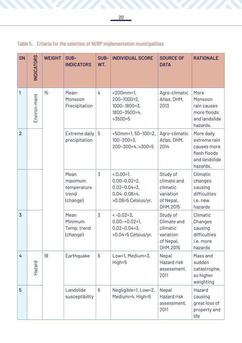
Indicators were classified into seven groups of indicators, and given statistical weightings.
1. Hazard (18% weight),2. Infrastructure (17% weight),3. Municipal capacity (16% weight),4. Environmental (15% weight),5. Social Structure and Economy (13% weight),6. Demography (11% weight),7. Existing development partners (10% weight). These seven groups of indicators were divided into sub-indicators as follows:
1. Hazardous (18% weight) Ð Earthquake (6% weight)
Ð Land-slide susceptibility (6% weight)
Ð Drought (6% weight)
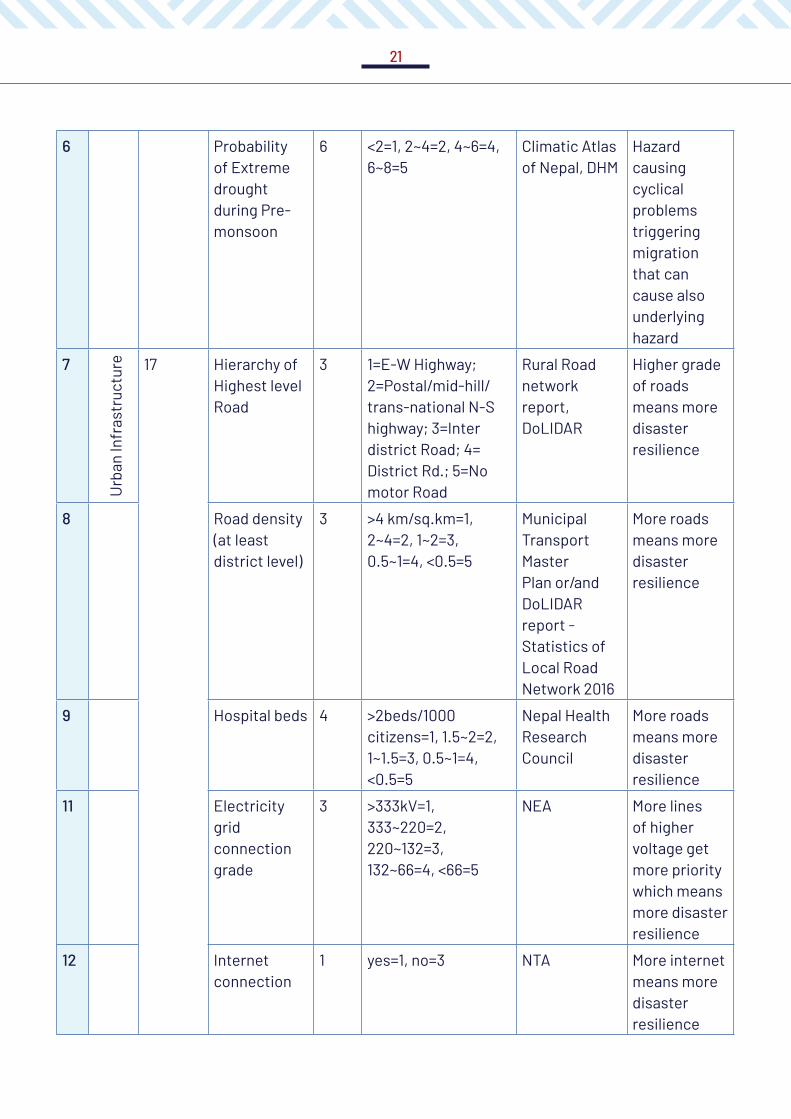
2. Infrastructure (17% weight) Ð Hierarchy of highest road (3% weight)
Ð Road density (3% weight)
Ð Hospital beds (4% weight)
Ð Electricity grid grade (3% weight)
Ð Internet bandwidth (1% weight)
Ð Number of schools (3% weight)
3. Municipal capacity (16% weight) Ð GESI focal point (3% weight)
Ð Fire brigade, (3% weight)
Ð Annual municipal revenue (this year not pertinent at this transition phase)
Ð Number of technical persons in municipality per 1000 citizens (3% weight)
Ð DRR section or focal person in the municipality (2% weight)
19
Ð Building code and Building Bye Laws (3% weight)
Ð Land use plan (2% weight)
4. Environmental (15 % weight) Ð Extreme daily precipitation, (5% weight)
Ð Mean Monsoon precipitation (4% weight)
Ð Mean maximum temperature trend (change) (3% weight)
Ð Mean minimum temperature trend (change), (3% weight)
5. Social Structure and Economy (13% weight) Ð Human Development Index (4% weight)
Ð Human Poverty index (4% weight)
Ð Total literacy rate (3% weight)
Ð Female literacy rate (2% weight)
6. Demography (11% weight) Ð Population density (4% weight)
Ð Population (4% weight)
Ð Population growth rate (3% weight)
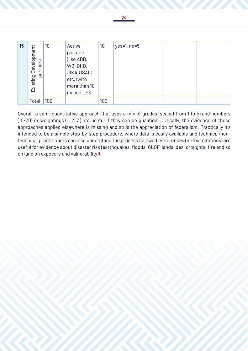
7. Involvement of development partners (10% weight), Ð Active major partners like DfID, JICA, ADB, WB etc. (10% weight).
The weightings were given basically with their relative importance and data reliability. The highest weighting was for ‘hazard’, followed by ‘infrastructure’, ‘municipal capacity’ and ‘environment’. ‘Resilience’, ‘demography’ and ‘involvement of development partners’ followed. Involvement of existing development partners, was afforded 10% weight to avoid overcrowding of urban projects in a municipality. If the development partners are already involved in the municipality, then it would get a lower score. This involvement could be even taken as an eligibility criterion.
Most of the classifications adopted are as given in the source documents. Some of the scores are not classified into five because the source documents do it differently. In such case the experts use the judgement to miss a class or club the classifications together.
These indicators were tested in four sample municipalities across the country. A separate table of test of indicators is given in Annex 5a and a summary table is given in Annex 5b.
The detail criteria for the weightings allocated to the indicators are shown in Table 5.
20
Table 5. Criteria for the selection of NURP implementation municipalities
SN
IND
ICAT
OR
S WEIGHT SUB-INDICATORS
SUB-WT.
INDIVIDUAL SCORE SOURCE OF DATA
RATIONALE
1
Env
iron
-men
t 15 Mean-Monsoon Precipitation
4 <200mm=1, 200~1000=2, 1000~1800=3, 1800~3500=4, >3500=5
Agro-climatic Atlas, DHM, 2013
More Monsoon rain causes more floods and landslide hazards.
2 Extreme daily precipitation
5 <50mm=1, 50~100=2, 100~200=3, 200~300=4, >300=5
Agro-climatic Atlas, DHM, 2014
More daily extreme rain causes more flash floods and landslide hazards.
Mean maximum temperature trend (change)
3 < 0.00=1, 0.00~0.02=2, 0.02~0.04=3, 0.04~0.06=4, >0.06=5 Celsius/yr.
Study of climate and climatic variation of Nepal, DHM,2015
Climatic changes causing difficulties i.e. new hazards
3 Mean Minimum Temp. trend (change)
3 < -0.02=3, 0.00~+0.02=1, 0.02~0.04=3, >0.04=5 Celsius/yr.
Study of Climate and climatic variation of Nepal, DHM,2015
Climatic Changes causing difficulties i.e. more hazards
4
Haz
ard
18 Earthquake 6 Low=1, Medium=3, High=5
Nepal Hazard risk assessment, 2011
Mass and sudden catastrophe, so higher weighting
5 Landslide susceptibility
6 Negligible=1, Low=2, Medium=4, High=5
Nepal Hazard risk assessment, 2011
Hazard causing great loss of property and life
21
6 Probability of Extreme drought during Pre-monsoon
6 <2=1, 2~4=2, 4~6=4, 6~8=5
Climatic Atlas of Nepal, DHM
Hazard causing cyclical problems triggering migration that can cause also underlying hazard
7
Urb
an In
fras
truc
ture 17 Hierarchy of
Highest level Road
3 1=E-W Highway; 2=Postal/mid-hill/trans-national N-S highway; 3=Inter district Road; 4= District Rd.; 5=No motor Road
Rural Road network report, DoLIDAR
Higher grade of roads means more disaster resilience
8 Road density (at least district level)
3 >4 km/sq.km=1, 2~4=2, 1~2=3, 0.5~1=4, <0.5=5
Municipal Transport Master Plan or/and DoLIDAR report - Statistics of Local Road Network 2016
More roads means more disaster resilience
9 Hospital beds 4 >2beds/1000 citizens=1, 1.5~2=2, 1~1.5=3, 0.5~1=4, <0.5=5
Nepal Health Research Council
More roads means more disaster resilience
11 Electricity grid connection grade
3 >333kV=1, 333~220=2, 220~132=3, 132~66=4, <66=5
NEA More lines of higher voltage get more priority which means more disaster resilience
12 Internet connection
1 yes=1, no=3 NTA More internet means more disaster resilience

22
13 No. of schools
3 >90=1, 90~70=2, 70~50=3, 50~30=4, 30 per 100,000 citizens=5
Department of Education or simple telephonic conservation
More school means resilient
14
Urb
an S
ocia
l str
uctu
re a
nd e
cono
my
13 Human Poverty Index (district data adjusted)
4 >0.5=5, 0.5~0.4=4, 0.4~0.3=3, 0.3~0.2=2, <0.2=1
CBS: Human Development Report,
HDI reflects the expansion of opportunities and choices, the Human Poverty Index (HPI) captures the denial as a result of income and capability deprivation.
15 HDI (district data adjusted)
4 >0.6=1, 0.6~0.5=2, 0.5~0.4=3, 0.4~0.3=4, <0.3=5
NHDR, 2014 Less HDI more vulnerable
16 Total literacy rate (district data adjusted)
3 1=>85%; 2=85-70%; 3=70-55%; 4=55-40%; 5=<40%
CBS Less literate more vulnerable
17 Female literacy rate (district data adjusted)
3 1=>85%; 2=85-70%; 3=70-55%; 4=55-40%; 5=<40%
CBS lLess literate more vulnerable
Mun
icip
al
Cap
acty 16 GESI focal
point3 yes=1, no=5 Simple
telephone call or email
Having capacity increases resilience
18 Fire brigade 3 yes=1, no=5 CBS No fire brigade means vulnerable

23
19 Annual municipal budget or revenue
0 1=>40,000; 2=40,000-25,000; 3=25,000-15,000; 4=15,000-10,000; 5=<10,000 (person/year)
Municipal Less budget increases vulnerability
21 No. of municipal technical staff 1000 citizens
3 5=1, 4=2, 3=3, 2=4, 1=5
Simple telephone call or email
More-technical staff results in more resilience
22 DRR sections/officer
2 yes=1, no=5 Simple telephone call or email
Existence of a DDR section/officer increases resilience
23 Building Code and Building Byelaws
3 yes=1, no=5 Simple telephone call or email
Use of the Building Code increases resilience
Land-use plan
2 yes=1, no=5 Simple telephone call or email
Land-use planning increases resilience
Dem
ogra
phy 11 Population 4 <50,000=1,
50,000~100,000=2, 100,000~200,000=3, 200,000~400,000=4, >400,000=5
CBS More people more hazard
Population density
4 <10=1, 10~100=2, 100~1000=3, 1000~10,000=4, >10,000=5
Greater density creates greater hazard
24 Population growth rate per year (2001~2011)
3 >8%=1, 8~4%=2, 4~2%=3, 2~1%=4, <1%=5
CBS (new data adjusted to the new boundaries)
24
15
Exi
stin
g D
evel
opm
ent
part
ners
10 Active
partners (like ADB, WB, DfID, JIKA,USAID etc.) with more than 10 million US$
10 yes=1, no=5
Total 100 100
Overall, a semi-quantitative approach that uses a mix of grades (scaled from 1 to 5) and numbers (10-20) or weightings (1, 2, 3) are useful if they can be qualified. Critically, the evidence of these approaches applied elsewhere is missing and so is the appreciation of federalism. Practically it’s intended to be a simple step-by-step procedure, where data is easily available and technical/non-technical practitioners can also understand the process followed. References (in-text citations) are useful for evidence about disaster risk (earthquakes, floods, GLOF, landslides, droughts, fire and so on) and on exposure and vulnerability.◗
25
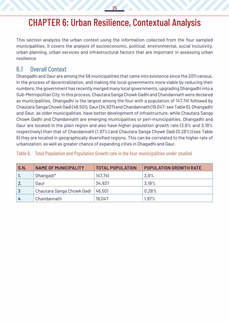
CHAPTER 6: Urban Resilience, Contextual Analysis
This section analyzes the urban context using the information collected from the four sampled municipalities. It covers the analysis of socioeconomic, political, environmental, social inclusivity, urban planning, urban services and infrastructural factors that are important in assessing urban resilience.
6.1 Overall ContextDhangadhi and Gaur are among the 58 municipalities that came into existence since the 2011 census. In the process of decentralization, and making the local governments more viable by reducing their numbers, the government has recently merged many local governments, upgrading Dhangadhi into a Sub-Metropolitan City. In this process, Chautara Sanga Chowk Gadhi and Chandannath were declared as municipalities. Dhangadhi is the largest among the four with a population of 147,741 followed by Chautara Sanga Chowk Gadi (46,501), Gaur (34,937) and Chandannath (19,047; see Table 6). Dhangadhi and Gaur, as older municipalities, have better development of infrastructure, while Chautara Sanga Chowk Gadhi and Chandannath are emerging municipalities or peri-municipalities. Dhangadhi and Gaur are located in the plain region and also have higher population growth rate (3.9% and 3.19% respectively) than that of Chandannath (1.97%) and Chautara Sanga Chowk Gadi (0.28%) (see Table 6) they are located in geographically diversified regions. This can be correlated to the higher rate of urbanization, as well as greater chance of expanding cities in Dhagadhi and Gaur.
Table 6. Total Population and Population Growth rate in the four municipalities under studied
S.N. NAME OF MUNICIPALITY TOTAL POPULATION POPULATION GROWTH RATE
1. Dhangadi* 147,741 3.9%
2. Gaur 34,937 3.19%
3 Chautara Sanga Chowk Gadi 46,501 0.28%
4 Chandannath 19,047 1.97%

26
The Dhangadi sub-metropolitan city has a greater population growth rate compare to other three municipalities. Population growth rate is least in Chautara Sanga Chowk Gadi Municipality.
Figure 2: Male and female population percentage of four municipalities is given bellow.
Chandannath municipality has 51% female population which is more than that of 49% of male population. Similarly, Chautara Sanga Chowk Gadi municipality has a 54% female and 46% male. Both municipalities have female population higher than male population.
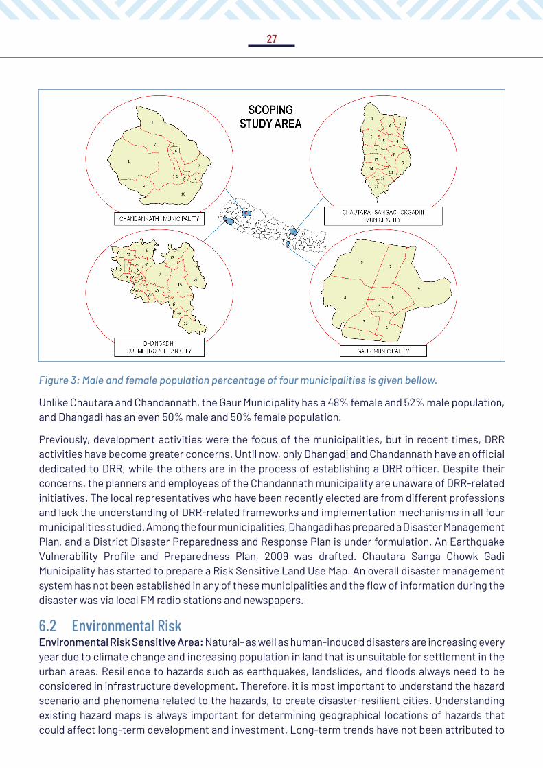
27
Figure 3: Male and female population percentage of four municipalities is given bellow.
Unlike Chautara and Chandannath, the Gaur Municipality has a 48% female and 52% male population, and Dhangadi has an even 50% male and 50% female population.
Previously, development activities were the focus of the municipalities, but in recent times, DRR activities have become greater concerns. Until now, only Dhangadi and Chandannath have an official dedicated to DRR, while the others are in the process of establishing a DRR officer. Despite their concerns, the planners and employees of the Chandannath municipality are unaware of DRR-related initiatives. The local representatives who have been recently elected are from different professions and lack the understanding of DRR-related frameworks and implementation mechanisms in all four municipalities studied. Among the four municipalities, Dhangadi has prepared a Disaster Management Plan, and a District Disaster Preparedness and Response Plan is under formulation. An Earthquake Vulnerability Profile and Preparedness Plan, 2009 was drafted. Chautara Sanga Chowk Gadi Municipality has started to prepare a Risk Sensitive Land Use Map. An overall disaster management system has not been established in any of these municipalities and the flow of information during the disaster was via local FM radio stations and newspapers.
6.2 Environmental RiskEnvironmental Risk Sensitive Area: Natural- as well as human-induced disasters are increasing every year due to climate change and increasing population in land that is unsuitable for settlement in the urban areas. Resilience to hazards such as earthquakes, landslides, and floods always need to be considered in infrastructure development. Therefore, it is most important to understand the hazard scenario and phenomena related to the hazards, to create disaster-resilient cities. Understanding existing hazard maps is always important for determining geographical locations of hazards that could affect long-term development and investment. Long-term trends have not been attributed to
28
natural and anthropogenic climate change; inevitably climate change adds a further layer of risk and uncertainty. Moreover, urban environmental issues are becoming increasingly important because of rural to urban migration and concentration of urban assets. The urbanization and migration trend are increasing in the context of Nepal and formal and informal settlements are putting pressure on environmental issues. The haphazard horizontal urbanization is increasing in recent years and urban poor are settled in the risk sensitive areas. Besides this, the seismically active Nepal Himalaya area, with fragile topography, is a key triggering factor to increase the natural hazards (Gnyawali and Adhikari, 2017).
Municipalities such as Chandannath and Chautara Sanga Chowk Gadhi have high environmental risk areas originating from susceptibility to landslides, flash floods and earthquakes. Chandannath lies in the higher Himalayan region on both sides of the Tila River. River bank cutting and slope failure are common with problems resulting from snow in the winter.
Solid-waste management is one of the major problems in the Chandannath municipality. Chautara Sanga Chowk Gadhi municipality lies on the ridge of the Mahabharat Lekh. This municipality has different kinds environmental risk-sensitive areas resulted from landslide and river toe cutting. Settlement pattern in this municipality lies in the both sides of the ridges. Non-engineered road constructions with slope-stability problems increase environmental risk. Dhangadi and Gaur municipalities lie in the lowlands of Nepal and have flood hazard problems. River toe cutting, unmitigated plastic waste in the urban areas and heat waves are responsible for increasing the environmental risk in those municipalities.
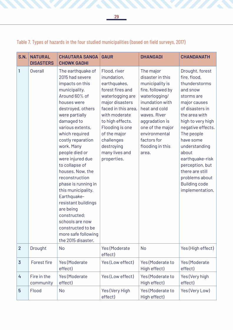
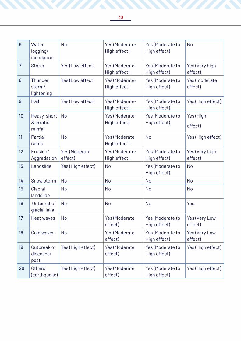
Types of Hazardous Areas: Chandannath, Dhangadi, Gaur and Chautara Sanga Chowk Gadhi municipalities have faced different kinds and scales of hazards in recent decades (Table 4). The distribution of hazards is predominantly dependent on the geographical location. The monsoon rain has often fluctuated, and changes in rainfall patterns that cause landslides in the hilly regions can result in river aggradation downstream. Although out-migration is caused by various forcing factors; climate change has also played a vital role in all municipalities. Flash floods and adverse weather condition have resulted in increased weathering rates in the area, enhancing erosion. Not only are the flood hazards of the Gaur and Dhangadi municipalities dependent on the rainfall and climatic conditions, changing climatic conditions on the Himalayan system, where small changes in climate, can cumulatively greatly alter the drainage patterns of the rivers. Besides this, toe cutting has resulted in many mass movements (landslides and rock falls), and shows the decline of water resources and increase climate-related disasters. Different DRR initiatives undertaken by municipalities are increasing urban resilience (Table 7).
29
Table 7. Types of hazards in the four studied municipalities (based on field surveys, 2017)
S.N. NATURAL DISASTERS
CHAUTARA SANGA CHOWK GADHI
GAUR DHANGADI CHANDANATH
1 Overall The earthquake of 2015 had severe impacts on this municipality. Around 60% of houses were destroyed, others were partially damaged to various extents, which required costly reparation work. Many people died or were injured due to collapse of houses. Now, the reconstruction phase is running in this municipality. Earthquake-resistant buildings are being constructed; schools are now constructed to be more safe following the 2015 disaster.
Flood, river inundation, earthquakes, forest fires and waterlogging are major disasters faced in this area, with moderate to high effects. Flooding is one of the major challenges destroying many lives and properties.
The major disaster in this municipality is fire, followed by waterlogging/ inundation with heat and cold waves. River aggradation is one of the major environmental factors for flooding in this area.
Drought, forest fire, flood, thunderstorms and snow storms are major causes of disasters in the area with high to very high negative effects. The people have some understanding about earthquake-risk perception, but there are still problems about Building code implementation.
2 Drought No Yes (Moderate effect)
No Yes (High effect)
3 Forest fire Yes (Moderate effect)
Yes (Low effect) Yes (Moderate to High effect)
Yes (Moderate effect)
4 Fire in the community
Yes (Moderate effect)
Yes (Low effect) Yes (Moderate to High effect)
Yes (Very high effect)
5 Flood No Yes (Very High effect)
Yes (Moderate to High effect)
Yes (Very Low)
30
6 Water logging/ inundation
No Yes (Moderate-High effect)
Yes (Moderate to High effect)
No
7 Storm Yes (Low effect) Yes (Moderate-High effect)
Yes (Moderate to High effect)
Yes (Very high effect)
8 Thunder storm/lightening
Yes (Low effect) Yes (Moderate-High effect)
Yes (Moderate to High effect)
Yes (moderate effect)
9 Hail Yes (Low effect) Yes (Moderate-High effect)
Yes (Moderate to High effect)
Yes (High effect)
10 Heavy, short & erratic rainfall
No Yes (Moderate-High effect)
Yes (Moderate to High effect)
Yes (High
effect)
11 Partial rainfall
No Yes (Moderate-High effect)
No Yes (High effect)
12 Erosion/Aggredation
Yes (Moderate effect)
Yes (Moderate-High effect)
Yes (Moderate to High effect)
Yes (Very high effect)
13 Landslide Yes (High effect) No Yes (Moderate to High effect)
No
14 Snow storm No No No No
15 Glacial landslide
No No No No
16 Outburst of glacial lake
No No No Yes
17 Heat waves No Yes (Moderate effect)
Yes (Moderate to High effect)
Yes (Very Low effect)
18 Cold waves No Yes (Moderate effect)
Yes (Moderate to High effect)
Yes (Very Low effect)
19 Outbreak of diseases/pest
Yes (High effect) Yes (Moderate effect)
Yes (Moderate to High effect)
Yes (High effect)
20 Others (earthquake)
Yes (High effect) Yes (Moderate effect)
Yes (Moderate to High effect)
Yes (High effect)
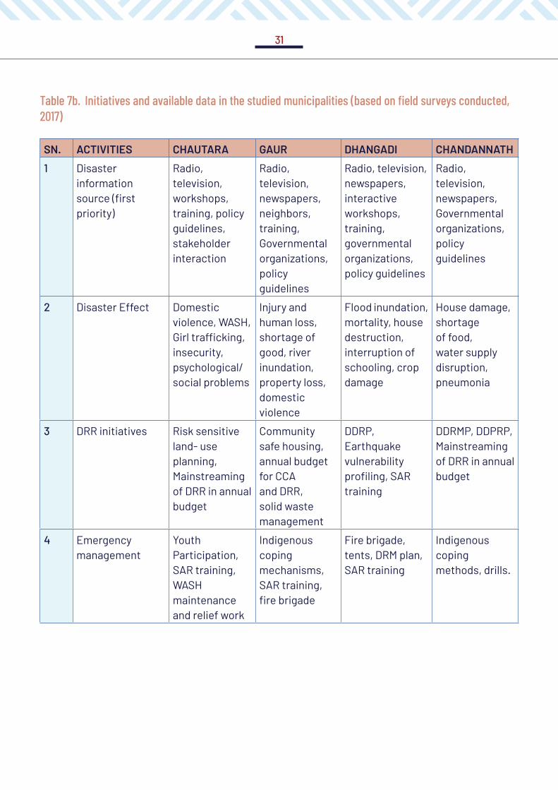
31
Table 7b. Initiatives and available data in the studied municipalities (based on field surveys conducted, 2017)
SN. ACTIVITIES CHAUTARA GAUR DHANGADI CHANDANNATH
1 Disaster information source (first priority)
Radio, television, workshops, training, policy guidelines, stakeholder interaction
Radio, television, newspapers, neighbors, training, Governmental organizations, policy guidelines
Radio, television, newspapers, interactive workshops, training, governmental organizations, policy guidelines
Radio, television, newspapers, Governmental organizations, policy guidelines
2 Disaster Effect Domestic violence, WASH, Girl trafficking, insecurity, psychological/social problems
Injury and human loss, shortage of good, river inundation, property loss, domestic violence
Flood inundation, mortality, house destruction, interruption of schooling, crop damage
House damage, shortage of food, water supply disruption, pneumonia
3 DRR initiatives Risk sensitive land- use planning, Mainstreaming of DRR in annual budget
Community safe housing, annual budget for CCA and DRR, solid waste management
DDRP, Earthquake vulnerability profiling, SAR training
DDRMP, DDPRP, Mainstreaming of DRR in annual budget
4 Emergency management
Youth Participation, SAR training, WASH maintenance and relief work
Indigenous coping mechanisms, SAR training, fire brigade
Fire brigade, tents, DRM plan, SAR training
Indigenous coping methods, drills.

32
5 Maps availability Topographic map up to governmental Ward level;
Land-use map (1:200000) in hard copy; drainage and river system maps; road network maps, soil moisture index maps; flood inundation maps; earthquake vulnerability maps
Topographic maps up to governmental Ward level;
Land-use map (1:380000) in hard copy
6.3 Gender Equality and Social InclusionPost 2015 Disaster Situation: Disasters have been found to reinforce, perpetuate and exacerbate gender inequality. Women’s contributions to Disaster Risk Reduction (DRR) are often overlooked and female voices and leadership in building community resilience are frequently disregarded. Women and children are 14 times more likely to die or be injured in a disaster than men19. Women, children, senior citizens, Persons Living With Disabilities (PLWD), Dalits (members of the occupational castes in society), minorities and other socially marginalized/disadvantaged groups are the most affected during disasters of any kind.
The poor and deprived communities have minimal accessibility to services and facilities and these groups are affected by many types of hazards such as floods, landslides, earthquakes, fire, epidemics and industrial accidents. The vulnerability is higher in communities that have low levels of access to a stable livelihood and services. The future of resilience development in communities is to develop nationally internal capacity to identify the hazards and risk, the adoption of risk reduction measures, preparedness and capability for response to hazards. Improved resilience is a proven principle in disaster management and climate-change adaptation20.
According to the information given by the GESI focal officer from the Nepal Red Cross Society and the Women’s Development Officer in Chautara, domestic violence against women increased after the 2015 earthquake disaster. During the post-earthquake period, the survivors had to live in tents or temporary settlements for a long time due to the slow reconstruction process. Domestic violence increased during that period. Married women faced domestic violence, and marital rape by drunken husbands. Some cases of marital rape were reported in the municipality. Through the information received from Chautara Sanga Chowk Gadhi Municipality, girls aged between the age of 10 to 16 faced a variety of problems regarding hygiene and sanitation, due to lack of proper facilities
19 https://www.gov.uk/government/uploads/system/uploads/attachment_data/file/236656/women-girls-
disasters.pdf
20 Final Draft Report National Strategy for Resilient Local Communities, 2017, Ministry of Federal Affairs and
Local Development, July 2017, Unofficial Translation.

33
in the emergency camps. During menstruation, the women and girls did not have access to sufficient sanitation facilities which affected their wellbeing. Many girls and women suffered from depression during the after effects of the earthquake. Trafficking of females also increased after the earthquake. Many outsiders and brokers were active in the communities and duped innocent girls with the promise of job opportunities, a better life, and better income and education opportunities. Children, women and elderly people felt very insecure due to death of family members and guardians, and they faced many social and mental problems. Many children stopped going to school and were deprived of education. Some children became engaged in labor work, and child trafficking also increased. The people living with disabilities were also severely affected by the disaster, due to lack of access to essential basic requirements, in circumstances of the emergency.
The above account implores that Government and humanitarian agencies engaged in urban resilience projects should ensure the minimum application of the core humanitarian standards in WASH, which focuses action on communities and people affected by a crisis. As a core standard, the CHS describes the essential elements of principled, accountable and high-quality humanitarian aid. It is a voluntary and measurable standard. The CHS is the result of a global consultation process.21
With regards to people’s knowledge about the effects of disasters on women, children, PLWD, elderly people and the poor and marginalized, it seems that the level of understanding of the people in the four municipalities that were analysed varied. From the information collected from Gaur, people were significantly affected by injury, death and crimes like rape, trafficking and domestic violence. Dhangadhi seemed to have very limited information. Chandannath Municipality in Jumla seemed to have even less information about the effects of disasters on the populace.
In Asia, women and girls traditionally have less access to, or control over, assets, which are necessary for coping and responding to disasters, compared to men. Women and girls also carry out unpaid domestic work and when disasters strike; they often experience an extreme increase in childbirth leading to girls withdrawing from school and supporting domestic work. Furthermore, the increasing effects of climate change exacerbate disaster risks and disproportionately affect the most vulnerable.22 All these factors combined make women the most affected social group in the aftermaths of disasters. The inequalities, discrimination, exclusion and poverty that women face increase their vulnerability to disasters and undermine their resilience to future disasters23. Therefore, there is urgent need to address the issues of urbanization and DRR from gender and social inclusion perspectives.
One of the key guiding principles of the National Strategy for Disaster Risk Management Nepal (March, 2008) and the final draft report of the National Strategy for Resilient Local Communities 2017 is discrimination. Some of the areas of focus concerning gender equality and social inclusion, as pointed out by the National Strategy for Disaster Risk Management Nepal (2009), are that all issues of gender and social inclusion will be mainstreamed into all phases of DRM and that arrangements will be made for informing children, women, senior citizens, and frail persons of all communities and that of minority communities to overcome obstacles to the uninterrupted operations of life-sustaining structures and systems in the community, even during obstructions to public services resulting from disasters.24
21 https://corehumanitarianstandard.org
22 UNISDR (2015) “Global Assessment Report”
23 PDNA Vol. B, Housing and Human Settlements and Gender Equality and Social Inclusion chapters
24 National Strategy for Disaster Risk Management Nepal 2009

34
According to the mid-term review on cross-cutting issues, “Inclusion of gender perspective and effective community participation are the areas where the least progress seems to have been made.”25 The trends in disaster risk reduction in the global context is moving from being ‘gender blind’ to gender sensitive and gender responsive. The Sendai Framework for Disaster Risk Reduction 2015 – 2030 emphasizes the importance of mainstreaming gender, age, disability and cultural sensitivity into all policies and programmes, and to increase the role of women and youth. Despite this, mainstreaming gender equality has not been sufficiently put into practice in many countries, including Nepal.26
The National Strategy for Disaster Risk Management, Nepal, also emphasizes that authorities and institutions for DRM and those made responsible for its implementation should ensure that DRR programs, including emergency response and relief, should be gender-sensitive based upon an understanding that class, caste, and ethnicity further complicate the scenario. Therefore, such division of labour should be identified, understood and analyzed prior to, during and post-disaster conditions. It also states that women of various categories – young, single, married, widowed, different ethnic groups, handicapped, sick individuals must be identified, and programs, therefore, targeted accordingly.27
To date all the four municipalities studied do not have a GESI official. In Dhangadi, the focal person for women and people living with disabilities is employed by a woman-and-child welfare organization. At a local government Ward level, consumer groups and women’s groups are active in reform and livelihood development. However, the Sub-Metropolitan City does not have GESI officer. In future, it is necessary to ensure that a GESI official is recruited in each municipality and he/she has adequate knowledge and skills to address GESI issues in urban-resilience projects.
6.3.1 Municipality Level Infrastructure and ServicesIn the Chautara Sanga Chowk Gadi Municipality, newly constructed governmental buildings have ramps up to plinth level for accessibility, and also include major interactive parts of offices at ground floor level which benefit disabled people, but others lack disabled-friendly infrastructure. Some of the governmental offices are located in rented residential buildings which do not address basic office standards for users. Similarly, most offices faced huge losses after the earthquake, so have settled in temporary structures. However, new construction does address disaster resilience and facilities for the disabled, along with gender-friendly structures. The Gaur Municipality has several infrastructure facilities and services such as municipal buildings, public toilets, parks, heritage areas and public playgrounds. Public toilets are gender friendly, but not necessarily easily accessible for the elderly or those people living with disabilities. Even the municipality office is not friendly towards people living with disabilities and is also not gender friendly. The municipality has included several specific plans for women, children, Dalit, and people living with disabilities, but progress is very slow regarding realization of the plans.
25 The UN Hyogo Framework for Action 2005 – 2015: Building the Resilience of Nations and Communities to
Disasters Mid Term Review. http://www.unisdr.org
26 Kathmandu Declaration, 2016 National Women’s Conference on Gender Responsive Disaster Management
March 1-2, 2016
27 National Strategy for Disaster Risk Management, Nepal, March 2008, Final Draft.
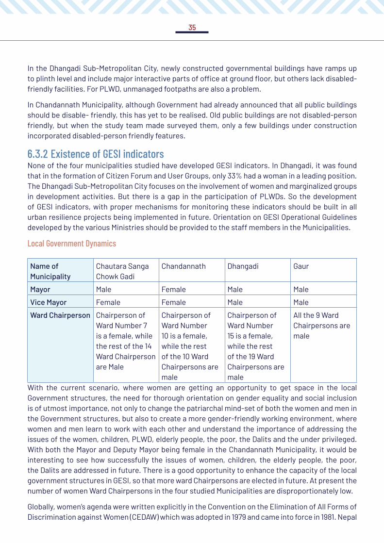
35
In the Dhangadi Sub-Metropolitan City, newly constructed governmental buildings have ramps up to plinth level and include major interactive parts of office at ground floor, but others lack disabled-friendly facilities. For PLWD, unmanaged footpaths are also a problem.
In Chandannath Municipality, although Government had already announced that all public buildings should be disable- friendly, this has yet to be realised. Old public buildings are not disabled-person friendly, but when the study team made surveyed them, only a few buildings under construction incorporated disabled-person friendly features.
6.3.2 Existence of GESI indicators None of the four municipalities studied have developed GESI indicators. In Dhangadi, it was found that in the formation of Citizen Forum and User Groups, only 33% had a woman in a leading position. The Dhangadi Sub-Metropolitan City focuses on the involvement of women and marginalized groups in development activities. But there is a gap in the participation of PLWDs. So the development of GESI indicators, with proper mechanisms for monitoring these indicators should be built in all urban resilience projects being implemented in future. Orientation on GESI Operational Guidelines developed by the various Ministries should be provided to the staff members in the Municipalities.
Local Government Dynamics
Name of Municipality
Chautara Sanga Chowk Gadi
Chandannath Dhangadi Gaur
Mayor Male Female Male Male
Vice Mayor Female Female Male Male
Ward Chairperson Chairperson of Ward Number 7 is a female, while the rest of the 14 Ward Chairperson are Male
Chairperson of Ward Number 10 is a female, while the rest of the 10 Ward Chairpersons are male
Chairperson of Ward Number 15 is a female, while the rest of the 19 Ward Chairpersons are male
All the 9 Ward Chairpersons are male
With the current scenario, where women are getting an opportunity to get space in the local Government structures, the need for thorough orientation on gender equality and social inclusion is of utmost importance, not only to change the patriarchal mind-set of both the women and men in the Government structures, but also to create a more gender-friendly working environment, where women and men learn to work with each other and understand the importance of addressing the issues of the women, children, PLWD, elderly people, the poor, the Dalits and the under privileged. With both the Mayor and Deputy Mayor being female in the Chandannath Municipality, it would be interesting to see how successfully the issues of women, children, the elderly people, the poor, the Dalits are addressed in future. There is a good opportunity to enhance the capacity of the local government structures in GESI, so that more ward Chairpersons are elected in future. At present the number of women Ward Chairpersons in the four studied Municipalities are disproportionately low.
Globally, women’s agenda were written explicitly in the Convention on the Elimination of All Forms of Discrimination against Women (CEDAW) which was adopted in 1979 and came into force in 1981. Nepal

36
ratified this convention in 1991. Similarly, the Fourth World Conference on Women held in Beijing in 1995 set out 12 Critical Areas of Concern, some of which are women and poverty, education and training of women, women and health, violence against women, women and armed conflict, women and the economy. The Critical Areas of Concern have played a crucial role in the development of the women sector in Nepal.28
The United Nations Security Council Resolution (UNSCR) 1325 was adopted in October 2000 and addresses not only the inordinate impact of war on women, but also acknowledged the pivotal role of women in conflict management, conflict resolution and sustainable peace. This resolution reaffirms the important role of women in the prevention and resolution of conflicts, peace negotiation, peace building, peacekeeping, humanitarian response and in post-conflict reconstruction and stresses the importance of their equal participation and full involvement in all efforts for the maintenance and promotion of peace and security.29 The Government of Nepal is also a signatory to this resolution and is committed in the application and implementation of this resolution.
The UN Resolution 1820, was adopted by the Security Council in June 2008 and demands immediate and complete halt to acts of sexual violence against civilians in conflict zones,30 to which the Government of Nepal, is also a signatory.
The Government of Nepal is also committed to the SDGs which has pointed out 17 areas of concern such as 1) no poverty, 2) no hunger, 3) good health and well-being, 4) quality education, 5) gender equality, 6) clean water and sanitation, 7) affordable and clean energy, 8) decent work and economic growth, 9) industry, innovation and infrastructure, 10) reduction of inequalities, 11) sustainable cities and communities, 12) responsible production and consumption, 13) climate action, 14) consideration of sea life, 15) consideration of life on land, 16) peace, justice and strong institutions and 17) partnership facilitating the achievement of its goals.31
The above findings from the field show that though proactive measures have been taken by the Government of Nepal in formulating effective policies regarding gender equality and social inclusion, much needs to be done in implementing these policies practically. For this purpose, specific recommendations are provided to ensure that the issues of gender equality and social inclusion are adequately addressed.
In all of the four municipalities that were studied, most of the necessary documentation does not yet exist, but they are least aware of GESI component in such documents. So future projects being implemented in DRR in the four municipalities that were studied should also consider in developing the above mentioned documents and ensure that there is a GESI and DRR component mainstreamed in these documents.
6.4 DRR Understanding and Data AvailabilityRegulatory Framework: Regarding each municipality’s understanding of the Legislative/Regulatory
28 Position Paper on Gender Responsive Disaster Preparedness and Risk Reduction in Nepal, Beyond
Beijing Committee, October 2016, Kathmandu, Nepal.
29 www.un.org/womenwatch
30 www.un.org/press/en/2008
31 Beyon Beijing Commmittee
37
Framework (NSDRM, NAPA, LAPA, DM Act, NSRLC, LDCRP, etc.)32, and wide dissemination of such a regulatory framework, it seems that all the four municipalities studied did not have much information regarding the legislative regulatory framework on disaster management. However, some staff in the Chautara Sanga Chowk Gadhi Municipality seemed to be aware of DRM framework. In Gaur, the municipality officials seem to be unaware of the use and importance of the DM Act and the NSDRM, but have been practicing LAPA, utilizing their own skills and knowledge based on the national framework. The municipality has not published any disaster-related regulatory framework, but the organizations working in the social sector in the municipality have prepared a disaster-related regulatory framework themselves. After the restructuring of the nation, all the Government sectors are combined and are under the auspices of the municipality office. Some of the officers, health officers and other private-sector officers have experience of disaster-related training. In the Dhangadi area, it seems that only a few staff and stakeholders are aware of the DRM Act. However, other regulatory frameworks like NSDRM, NAPA, LAPA, the DM Act, NSRLC, LDCRP, etc. are not disseminated widely. In Chandannath Municipality in Jumla, the staff seemed to have limited awareness about the legislative framework. The NCCSP program is focused on implementation of LAPA which is being conducted by the DCC office. However, they are not aware about the other regulatory framework on DRR and they are not widely distributed.
With the above analysis of the information from the four municipalities studied, it seems that their understanding of the various legislative/regulatory framework and GESI component in such frameworks is very limited. Their understanding of discrimination and the issues of the poor, women, PLWD, children, the elderly people and the Dalits and socially excluded during times of disaster also seems to be limited. Future projects on DRR should ensure that the different legislative/regulatory frameworks are widely disseminated. The DRR projects should also give priority to the fact that mainstreaming GESI in DRR requires strategic interventions at all levels in the municipalities, such as institutional arrangements, existence of GESI strategy, recruitment of a GESI Unit/focal person, capacity-development mechanisms, development of specific indicators on GESI and regular system of monitoring and evaluation, developing disaggregated data on GESI and proper documentation with focus on GESI, best practices and lessons learned. However, based on the information collected from all the four municipalities under study, it seems that all these aspects are far from being achieved. Since the staff in all the four municipalities did not have much information on all the legislative/regulatory frameworks on DRR, it was clear that they did not know much about the GESI component in the regulatory framework and the importance of giving priority to the issues of the vulnerable groups in times of disaster.
Data Availability: In Chautara Sanga Chowk Gadi, organizations like the Nepal Red Cross Society and Women and Children Development Office have identified the vulnerable and disadvantaged groups, and are working towards strengthening them. After disasters, women, children, elderly people, persons with disabilities, the poor and socially disadvantaged are more vulnerable in society and they are affected the most. However, the municipality does not have vulnerability data.
In the Gaur Municipality, officials do have understanding and appreciation of who is vulnerable.
32 National strategy on disaster risk management, National adaptation plan of action, Local adaptation
programme of action, disaster management act, National Strategy for Resilient Local Communities, local
disaster & climate resilience planning guideline
38
The poor, elderly and people living with disabilities have been recognised as vulnerable people. Flood is the major disaster in this region, and there are also some incidents of house fires in poor communities. Houses of the poor have been damaged by various types of disaster. Women, children and people living with disabilities were victims of crime during disasters in the past. Though local representatives and officials are aware of such vulnerability, they do not have data of vulnerability and vulnerability assessment has not been conducted.
In the Dhangadi Sub-Metropolitan City, organizations like the Nepal Red Cross Society and Mercy Corps have identified the vulnerable and weak groups, and are implementing various activities to strengthen their protection. According to them, people living on river banks, single women, PLWD, Dalits and women and children residing in disadvantaged communities are more vulnerable. However, they do not have a data of vulnerability and vulnerability assessments have not been carried out formally.
In the Chandannath Municipality in Jumla, the staff members have understanding about who is vulnerable. The Nepal Red Cross Society, in coordination with DAO and municipality officials, have identified vulnerability concerning landslides and floods.
With this analysis of who is vulnerable and the existence of vulnerability mapping, it seems that in all the four municipalities under study, people are aware of who is vulnerable, but to date there has been no vulnerability assessment carried out and there is no vulnerability data, except for the Chandannath Municipality.
DRR Section or Unit: In the Chautara Sanga Chowk Gadi Municipality, there is no section or unit that deals with disasters, but there is a plan to make a separate unit that deals with them in the near future. At present, the Section Officer of the municipality is responsible for collection and dissemination of information on disasters. In the same manner, there is a Ward Citizen Forum in each ward, which is responsible for the collection and dissemination of information on disaster, to the municipality officials and the general public. This is the same with the Gaur Municipality. There is no separate section or unit that deals with disaster, but local representatives and executive officer in the Municipality have been coordinating with DAO, the Nepal Red Cross Society and other agencies during times of disaster. In Dhangadi there is also no section or unit that deals with disaster. The Local Development Section inside the municipality is responsible for the collection and dissemination of information on disaster. In Chandan Nath Municipality there is no dedicated unit or section, but they have a DRR representative selected by the municipality. This shows that in all the four studied municipalities there is no dedicated section or unit that deals with disasters, but they have different kinds of mechanisms to collect and disseminate information when disaster occurs.
Disaster Information Management System: The Chautara Sanga Chowk Gadi Municipality does not have a disaster information management system. However, at the district level, the District Emergency Operation Center (DEOC) is responsible for a disaster information management system. To date, the DEOC is responsible for disaster-related work by collecting and analyzing information. It coordinates with all relevant agencies along with municipality officials and disseminates information on disasters to stakeholders. It provides humanitarian assistance and works in preparedness activities. In the Gaur Municipality there is also no disaster information management system. In the Dhangadi Municipality, there is a display board at the CDO office which helps in early warning. They also have group SMS systems installed to disseminate information to various sections and
39
departments. In the Chandannath Municipality, there is no such disaster information management system; however, the DAO has a section called ‘DEOC’ which disseminates information to the Ministry of Home Affairs and the local people.
6.5 Coordination: Municipality and the External ActorsIn the Chautara Sanga Chowk Gadi Municipality, the linkage between the municipality officials and the external actors (the Red Cross, NGOs and the private sector (banks and insurance companies, cooperatives, real estate companies, building contractors, and suppliers) seems to be weak. There needs to be more-effective communication and collaboration with the external actors and the municipality. Regarding linkage and coordination with the Gaur Municipality, the Nepal Red Cross Society, UNICEF, WFP, OXFAM and RDC have been coordinating with the municipality, and some local organizations, including the Junior Red Cross Society and Nepal Scouts are involved in social work. In the Chandannath Municipality in Jumla, there is good coordination between the municipality officials and the Nepal Red Cross Society. They have worked together to prepare DDRMP, DDPRP and so on. Also, the NGOs use the Plan and Policy created by the municipality, the DAO, and implement in their projects. The Dhangadi Municipality is working in coordination with FAYA, the Nepal Red Cross Society, CARE Nepal, OXFAM, World Vision International, Mercy Corps and implementing different kinds of programmes. These organizations are also helping in policy formulation.
External Actors: In the Chautara Sanga Chowk Gadhi Municipality, there are a number of organizations working on DRR, such as the World Health Organization, UNICEF, the Nepal Swastha Chetra, Sahayog Karyakram, the World Food Program, Health for Life USAID, World Vision International, MDM France, Tuki Sang Sunkoshi, the Energy with Environment Development Organization, the Community Forestry Users Group, Janahit Grahmin Sewa Samiti, the Community Forest and Research Training Center, Love Green Nepal, Anti human-trafficking and selling program, Sindhu Bikash Kendra and Gatisil Grahmin Uthan Kendra. According to the information gathered, it seems that in all these organizations, GESI is being considered very seriously. So it would be beneficial if a municipality-level GESI network were to be established, so that all the organizations could learn from each other about the issues of GESI, and the officials could expand their knowledge and skills. The situation is similar for the Dhangadi and Gaur municipalities. The organizations working on DRR in the Dhangadi Municipality are FAYA, the Nepal Red Cross Society, Mercy Corp, World Vision, CARE Nepal, Sewak Nepal and CCS. The organizations working in the Gaur Municipality are the World Food Program, UNICEF, Poverty Alleviation Fund, the Nepal Red Cross Society, the Mission for Better Life, the Nepal Scouts, the Rural Development Center, Oxfam, the Mission Sakshya Yuwak Nepal, Help Line Nepal, READ Nepal, the Rural Youth Federation for Social Services Nepal, and the Rural Education Development Center. The Chandannath Municipality seems to have only two organizations working on DRR, which are the Rural Reconstruction Nepal and PACE Nepal.

40
Table 8: External Actors working with the four municipalities under study in DRR
S.N. CHAUTARA CHANDAN NATH GAUR DHANGADI
World Health Organization,
Rural Reconstruction Nepal
World Food Program,
FAYA
UNICEF PACE Nepal UNICEF Nepal Red Cross Society
Nepal Swastha Chetra, Sahayog Karyakram
Nepal Red Cross Society
Poverty Alleviation Fund
Mercy Crop
World Food Program Nepal Red Cross Society
Mission for Better Life
Health for Life USAID Mission for Better Life
Nepal Scouts
World Vision International
Nepal Scouts Rural Development Center
MDM France Rural Development Center
Oxfam
Tukhi Sang Sunkoshi Oxfam Mission Sakshya Yuwak Nepal
Energy with Environment Development Organization
Mission Sakshya Yuwak Nepal
Help Line Nepal
Community Forestry Users Group
Help Line Nepal, READ Nepal
READ Nepal
Janahit Grahmin Sewa Samiti
Rural Youth Federation for Social Services Nepal
Rural Youth Federation for Social Services Nepal
Community Forest and Research Training Center
Rural Education Development Center
Rural Education Development Center.
Love Green Nepal CARE Nepal
Anti-human trafficking and selling program
Sindhu Bikash Kendra and Gatisil Grahmin Uthan Kendra
41
6.6 Indigenous Coping Mechanisms In the Chautara Sanga Chowk Gadi Municipality, there is no documentation about indigenous coping mechanisms in the time of disaster and emergencies, as is also the case with Dhangadi. In the Chandannath Municipality, there is a practice of using Lintel and Sill Band in building construction. They also construct ponds near houses which are used for animals primarily, but the water can be used in case of fire. Other indigenous methods are building small wooden dams, establishing plantations for flood, setting small retaining walls made of wood, creating plantations for protection against landslides, and erecting small community constructions called ‘Pati’ for snow fall and hailstones. However, there is no systematic documentation for such methods. In the Gaur Municipality, indigenous coping mechanisms are followed as far as possible, but no specific information is provided on them. However, the local representatives are planning to improve the indigenous coping mechanisms, as well as adapt to new technologies. The present analysis shows that all four municipalities under study do not have systematic documentation of the indigenous coping mechanisms.
6.7 Planning: Infrastructures and ServicesPeriodic and annual plans have been the basis for development activities as well as services in municipalities. All the municipalities have prepared annual plan for financial year 2074/75, while some of them have prepared periodic plans in the past, none had been prepared at the time of study. Disaster management plans need to be incorporated in such plans. At present, government has emphasized the need to prepare an Integrated Urban Development Plan (IUDP) for the development of planned Urban Areas. In an IUDP there is room for Disaster Risk Management Plan (DRMP). These four sample municipalities have not prepared yet IUDP, hence, annual plans have been considered as the fundamental guiding framework for operating the programs by all municipalities. In addition, the policy and programs launched by Nepal Government and ministries of different sectors also became the framework of an annual plan. Local government elections were held recently and new members were busy with preparing Annual Plan when the study team surveyed the municipalities.
The status of various plans and their implementation status in the sampled municipalities are presented in the table below (Table 9).
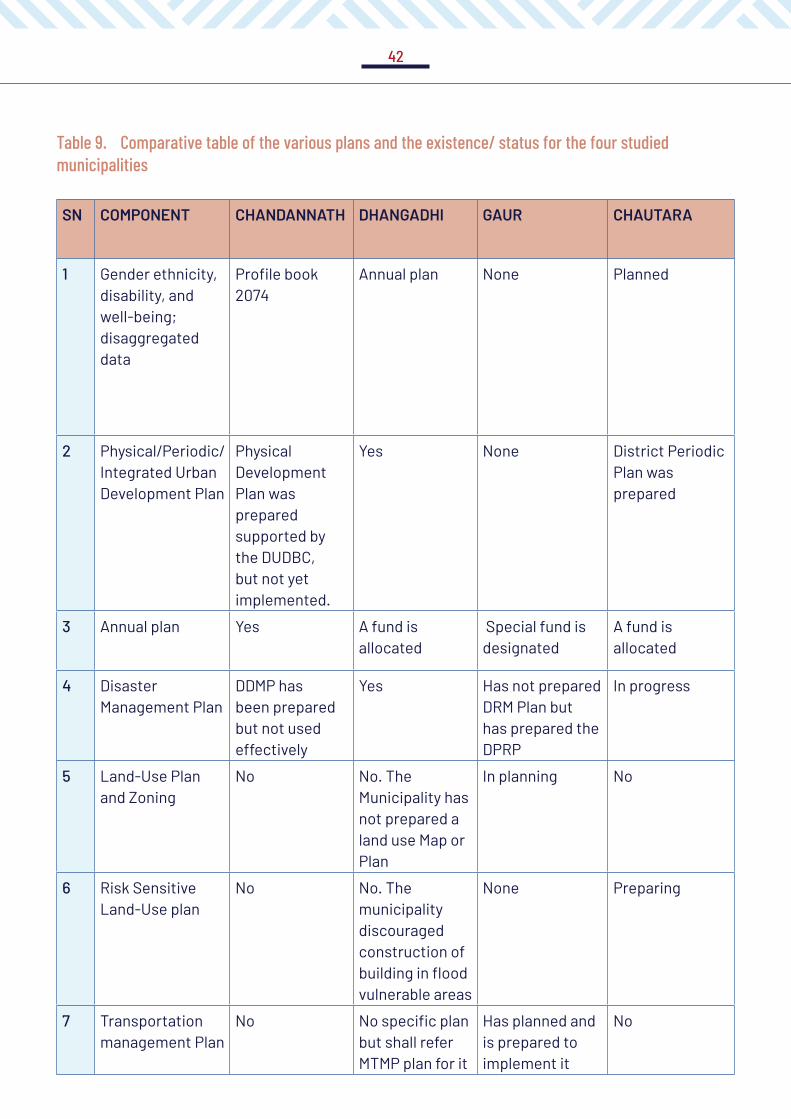
42
Table 9. Comparative table of the various plans and the existence/ status for the four studied municipalities
SN COMPONENT CHANDANNATH DHANGADHI GAUR CHAUTARA
1 Gender ethnicity, disability, and well-being; disaggregated data
Profile book 2074
Annual plan None Planned
2 Physical/Periodic/ Integrated Urban Development Plan
Physical Development Plan was prepared supported by the DUDBC, but not yet implemented.
Yes None District Periodic Plan was prepared
3 Annual plan Yes A fund is allocated
Special fund is designated
A fund is allocated
4 Disaster Management Plan
DDMP has been prepared but not used effectively
Yes Has not prepared DRM Plan but has prepared the DPRP
In progress
5 Land-Use Plan and Zoning
No No. The Municipality has not prepared a land use Map or Plan
In planning No
6 Risk Sensitive Land-Use plan
No No. The municipality discouraged construction of building in flood vulnerable areas
None Preparing
7 Transportation management Plan
No No specific plan but shall refer MTMP plan for it
Has planned and is prepared to implement it
No
43
8 Municipal drainage (storm) management Plan
No This was made in 2017, but not yet initiated
Has planned to prepare and implement one
No
9 Building bye-laws No
It uses other municipality’s byelaws
Implementing Followed Following byelaws with some necessary amendment
10 Planning byelaws No Being implemented
Following Guidelines for Township
Following Fundamental Guidelines for Township Development, Urban Planning and Building Construction
11 Status of National Building Codes
Initiation NBC is in practice
Planned to implement NBC to new construction and has called to register old houses for record keeping. The Municipality has mentioned ‘One House, Two Trees’ program for new construction but is having difficulties in implementation
Following NBC. The municipality has planned to implement NBC to new construction and has called to register old houses for record keeping

44
12 Enforcement status of NBC
No penalty Became conscious about the construction techniques and byelaws.
Municipality has requested everyone to follow the byelaws.
Nepal Reconstruction Authorities (NRA) has made own byelaw called MR (minimum requirement) for both masonry and RC structure building
Disaster Management (including response) Plan
Yes, DCC with DAO has just prepared a DDRM Plan
DPRP report, 2073 is at final stage, DRM plan 2070 is under implementation
Not specific Disaster management plan is in process
Future Plans and Programs with Urban DRR
Trying to mainstream DRR in Development works but does not seem effective
Trying to mainstream DRR in Development works but does not seem effective
Trying to mainstream DRR in Development works but does not seem effective
Until now there are no targeted future plans or programs with urban DRR
45
Development activities
Road construction in core areas. The drainage system is being reconstructed; NCCSP program From DCC is Implementing LAPA in the whole district
Master plan for drainage, annual plans separately focusing on women and marginalized groups
Environment Friendly Local Governance, Children Friendly Local Governance, Open Discrete Free Municipality in progress, Solid Waste Management and Landfill sites, awareness program on how to be safe during cold wave as well as mosquito infestation, alert and good conditioning of fire brigades, proper management and maintenance
Rehabilitation of water supply
Annual, periodic, DRR, etc.) in the context of changed a) Municipal boundary, b) Governance system
Allocated budget to each Ward
Municipality plans to work with integrated development
Local representatives and municipality officials are dedicated to adopt various plans
After the municipality boundary formation and new local representatives selected, an annual plan has been made which has addressed all new added Wards
Open spaces Playground
4000
Approximate 100000 m2
School ground 35000 m2
10000 m2
Government declared open spaces within municipality
Tudikhel No No Tudikhel, all activities in the time of earthquake.
46
Building Bylaws and Building Code: Chautara Sanga Chowk Gadi Municipality is applying building byelaws and the Building code in core areas, but this municipality has many rural areas. Due to the lack of awareness and inaccessibility to information and knowledge, people are unaware of building byelaws and building code, especially in rural areas. However, after the 2015 earthquake, the reconstruction phase has been ongoing throughout the municipality. Building permit issue has been very slow, thus to help the house owners to speed up their house building, the municipality has allowed them to construct earthquake-resistant buildings without pre-permission, but they must register and seek permission afterwards. Usually, engineers from NRA are required to prepare drawings and also supervise constructions in the field for checking. But with the support from UNDP and Institute of Engineering (IOE), the Department of Architecture prepared designs of several hundreds of houses for poor people who could not spend large sums for the design of their buildings following building byelaws and the Building code. The Nepal Reconstruction Authorities (NRA) made their own byelaws calling for ‘MR’ (Minimum Requirement) for both masonry and RC structure building. It has created prototype structure plans for buildings and is encouraging people to follow them, or get the construction checked by the NRA engineers to get grant money for reconstruction of houses. People who are reconstructing buildings are now following Mandatory Rules of Thumb widely. In the Gaur Municipality, due to lack of education, and poverty, people are unaware of building bylaws and official building codes and so are not following these rules and regulations in the rural areas. In the Dhangadi Sub-Metropolitan City, after the 2015 Gorkha earthquake, people have become conscious about using building codes and byelaws, but are not sure whether they are following the bylaws properly for building construction in urban periphery. In the Chandannath Municipality in Jumla, people in core areas are starting to follow codes or practice, but this is not yet implemented universally.
Roads: Road projects have been considered as fundamental development projects by all the municipalities. The major sources of funds for road are internal revenue of each municipality and the grants from the Road Board Nepal (RBN) and other agencies. Each municipality has been allotting funds for the construction, upgrade and maintenance of the road services as a priority. The RBN has been coordinating with the Gaur Municipality for the upgrade of existing road services. Similarly, the Chautara Sanga Chowk Gadi Municipality has been receiving several indirect funding (conditional grants) for the infrastructural development including road construction (Table 10).
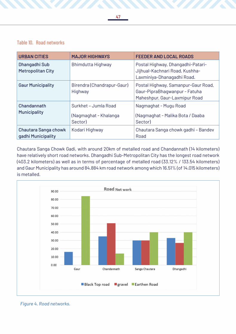
47
Table 10. Road networks
URBAN CITIES MAJOR HIGHWAYS FEEDER AND LOCAL ROADS
Dhangadhi Sub Metropolitan City
Bhimdutta Highway Postal Highway, Dhangadhi-Patari-Jijhual-Kachnari Road, Kushha-Laxminiya-Dhanagadhi Road.
Gaur Municipality Birendra (Chandrapur-Gaur) Highway
Postal Highway, Samanpur-Gaur Road, Gaur-PipraBhagwanpur - Fatuha Maheshpur, Gaur-Laxmipur Road
Chandannath Municipality
Surkhet – Jumla Road
(Nagmaghat - Khalanga Sector)
Nagmaghat - Mugu Road
(Nagmaghat - Malika Bota / Daaba Sector)
Chautara Sanga chowk gadhi Municipality
Kodari Highway Chautara Sanga chowk gadhi – Bandev Road
Chautara Sanga Chowk Gadi, with around 20km of metalled road and Chandannath (14 kilometers) have relatively short road networks. Dhangadhi Sub-Metropolitan City has the longest road network (403.2 kilometers) as well as in terms of percentage of metalled road (33.12% / 133.54 kilometers) and Gaur Municipality has around 84.884 km road network among which 16.51% (of 14.015 kilometers) is metalled.
Figure 4. Road networks.
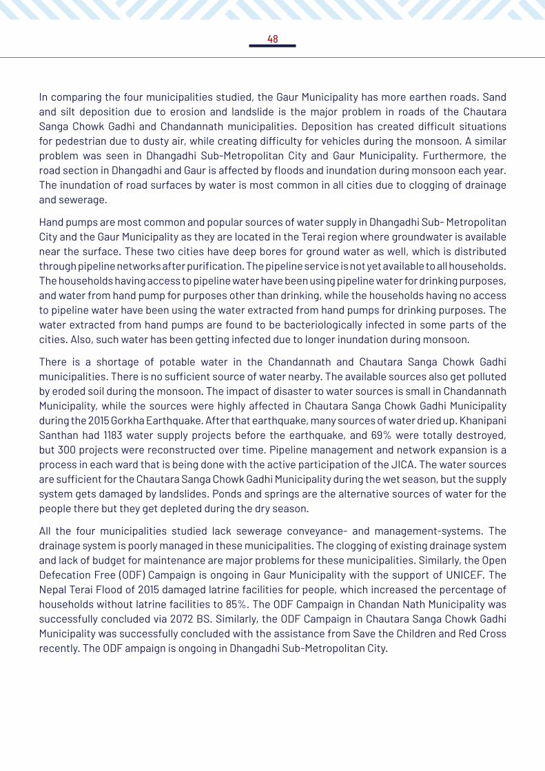
48
In comparing the four municipalities studied, the Gaur Municipality has more earthen roads. Sand and silt deposition due to erosion and landslide is the major problem in roads of the Chautara Sanga Chowk Gadhi and Chandannath municipalities. Deposition has created difficult situations for pedestrian due to dusty air, while creating difficulty for vehicles during the monsoon. A similar problem was seen in Dhangadhi Sub-Metropolitan City and Gaur Municipality. Furthermore, the road section in Dhangadhi and Gaur is affected by floods and inundation during monsoon each year. The inundation of road surfaces by water is most common in all cities due to clogging of drainage and sewerage.
Hand pumps are most common and popular sources of water supply in Dhangadhi Sub- Metropolitan City and the Gaur Municipality as they are located in the Terai region where groundwater is available near the surface. These two cities have deep bores for ground water as well, which is distributed through pipeline networks after purification. The pipeline service is not yet available to all households. The households having access to pipeline water have been using pipeline water for drinking purposes, and water from hand pump for purposes other than drinking, while the households having no access to pipeline water have been using the water extracted from hand pumps for drinking purposes. The water extracted from hand pumps are found to be bacteriologically infected in some parts of the cities. Also, such water has been getting infected due to longer inundation during monsoon.
There is a shortage of potable water in the Chandannath and Chautara Sanga Chowk Gadhi municipalities. There is no sufficient source of water nearby. The available sources also get polluted by eroded soil during the monsoon. The impact of disaster to water sources is small in Chandannath Municipality, while the sources were highly affected in Chautara Sanga Chowk Gadhi Municipality during the 2015 Gorkha Earthquake. After that earthquake, many sources of water dried up. Khanipani Santhan had 1183 water supply projects before the earthquake, and 69% were totally destroyed, but 300 projects were reconstructed over time. Pipeline management and network expansion is a process in each ward that is being done with the active participation of the JICA. The water sources are sufficient for the Chautara Sanga Chowk Gadhi Municipality during the wet season, but the supply system gets damaged by landslides. Ponds and springs are the alternative sources of water for the people there but they get depleted during the dry season.
All the four municipalities studied lack sewerage conveyance- and management-systems. The drainage system is poorly managed in these municipalities. The clogging of existing drainage system and lack of budget for maintenance are major problems for these municipalities. Similarly, the Open Defecation Free (ODF) Campaign is ongoing in Gaur Municipality with the support of UNICEF. The Nepal Terai Flood of 2015 damaged latrine facilities for people, which increased the percentage of households without latrine facilities to 85%. The ODF Campaign in Chandan Nath Municipality was successfully concluded via 2072 BS. Similarly, the ODF Campaign in Chautara Sanga Chowk Gadhi Municipality was successfully concluded with the assistance from Save the Children and Red Cross recently. The ODF ampaign is ongoing in Dhangadhi Sub-Metropolitan City.
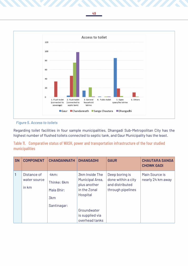
49
Figure 5. Access to toilets
Regarding toilet facilities in four sample municipalities, Dhangadi Sub-Metropolitan City has the highest number of flushed toilets connected to septic tank, and Gaur Municipality has the least.
Table 11. Comparative status of WASH, power and transportation infrastructure of the four studied municipalities
SN COMPONENT CHANDANNATH DHANGADHI GAUR CHAUTARA SANGA CHOWK GADI
1 Distance of water source
in km
4km:
Thinke: 6km
Mala Bhir:
3km
Santinagar:
3km Inside The Municipal Area, plus another in the Zonal Hospital
Groundwater is supplied via overhead tanks
Deep boring is done within a city and distributed through pipelines
Main Source is nearly 24 km away
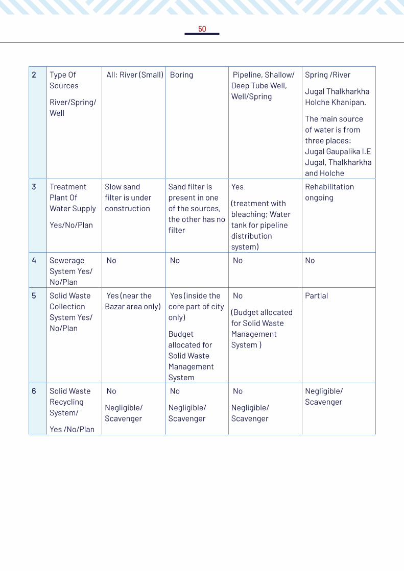
50
2 Type Of Sources
River/Spring/Well
All: River (Small) Boring Pipeline, Shallow/Deep Tube Well, Well/Spring
Spring /River
Jugal Thalkharkha Holche Khanipan.
The main source of water is from three places: Jugal Gaupalika I.E Jugal, Thalkharkha and Holche
3 Treatment Plant Of Water Supply
Yes/No/Plan
Slow sand filter is under construction
Sand filter is present in one of the sources, the other has no filter
Yes
(treatment with bleaching; Water tank for pipeline distribution system)
Rehabilitation ongoing
4 Sewerage System Yes/No/Plan
No No No No
5 Solid Waste Collection System Yes/No/Plan
Yes (near the Bazar area only)
Yes (inside the core part of city only)
Budget allocated for Solid Waste Management System
No
(Budget allocated for Solid Waste Management System )
Partial
6 Solid Waste Recycling System/
Yes /No/Plan
No
Negligible/Scavenger
No
Negligible/Scavenger
No
Negligible/Scavenger
Negligible/Scavenger

51
7 Landfill Site Yes/No
/Plan
Yes
(Present-day landfill site is close to proposed bus station (about 300m from the Tila River).
A proposed dumping site is 3km north-east of the Airport (about 2km from the Tila River)
Landfill site is under construction.
At present solid waste is placed in lowland areas or the bank cut by the river.
No Site is 2km away (Pokhare) Funding is being sought.
8 Electric Power 133 Kv Yes/No/Plan
NO (Local Hydropower)
Yes
Substation is closest to the core part of the municipality, 133 KV Station is at the NEA Office in Chauraha, I.E. Around 2.5 Km away from the Municipality office
132KV Station is at Attariya,
Yes
Substation In Gaur Municipality 133 KV Line in Chandranigahapur (40 Km away)
No
133KV Transmission Line. 11KV The transmission Line has been sub-stationed at the boundary of Chautara Sanga Chowk Gadhi Municipality. Sunkoshi Hydropower at 10.05 MW is the main source of supply
9 Cooking Energy Major source: Firewood/LPG/Other
Mainly Firewood and LPG
Mainly Firewood and LPG
Mainly Firewood and LPG
Mainly Firewood and LPG
10 Road % Tarmac (metalled) /Gravel/Earthen
45% metalled, 55% Earthen
16% metalled, 84% Earthen
16% metalled, 84% Earthen
40% metalled, 30% Earthen/30% Gravel
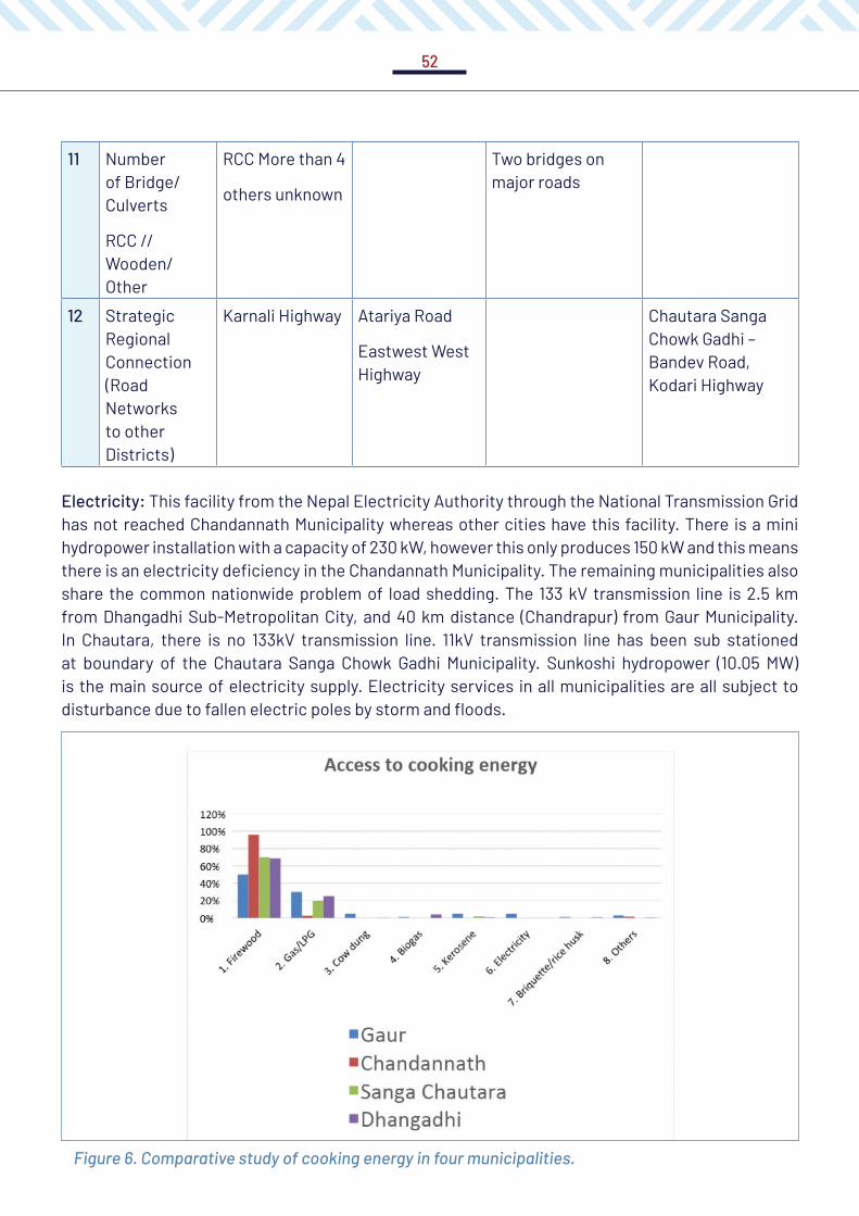
52
11 Number of Bridge/Culverts
RCC //Wooden/Other
RCC More than 4
others unknown
Two bridges on major roads
12 Strategic Regional Connection (Road Networks to other Districts)
Karnali Highway Atariya Road
Eastwest West Highway
Chautara Sanga Chowk Gadhi – Bandev Road, Kodari Highway
Electricity: This facility from the Nepal Electricity Authority through the National Transmission Grid has not reached Chandannath Municipality whereas other cities have this facility. There is a mini hydropower installation with a capacity of 230 kW, however this only produces 150 kW and this means there is an electricity deficiency in the Chandannath Municipality. The remaining municipalities also share the common nationwide problem of load shedding. The 133 kV transmission line is 2.5 km from Dhangadhi Sub-Metropolitan City, and 40 km distance (Chandrapur) from Gaur Municipality. In Chautara, there is no 133kV transmission line. 11kV transmission line has been sub stationed at boundary of the Chautara Sanga Chowk Gadhi Municipality. Sunkoshi hydropower (10.05 MW) is the main source of electricity supply. Electricity services in all municipalities are all subject to disturbance due to fallen electric poles by storm and floods.
Figure 6. Comparative study of cooking energy in four municipalities.
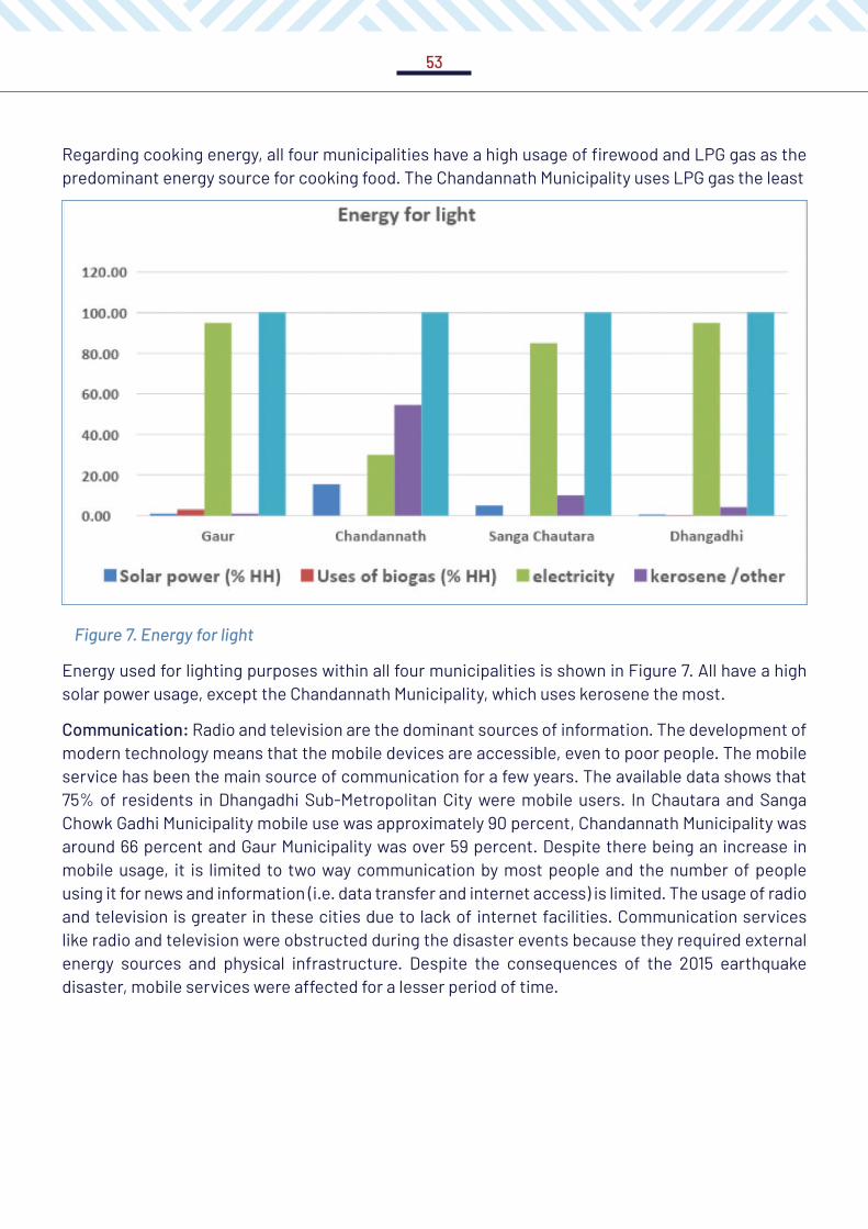
53
Regarding cooking energy, all four municipalities have a high usage of firewood and LPG gas as the predominant energy source for cooking food. The Chandannath Municipality uses LPG gas the least
Figure 7. Energy for light
Energy used for lighting purposes within all four municipalities is shown in Figure 7. All have a high solar power usage, except the Chandannath Municipality, which uses kerosene the most.
Communication: Radio and television are the dominant sources of information. The development of modern technology means that the mobile devices are accessible, even to poor people. The mobile service has been the main source of communication for a few years. The available data shows that 75% of residents in Dhangadhi Sub-Metropolitan City were mobile users. In Chautara and Sanga Chowk Gadhi Municipality mobile use was approximately 90 percent, Chandannath Municipality was around 66 percent and Gaur Municipality was over 59 percent. Despite there being an increase in mobile usage, it is limited to two way communication by most people and the number of people using it for news and information (i.e. data transfer and internet access) is limited. The usage of radio and television is greater in these cities due to lack of internet facilities. Communication services like radio and television were obstructed during the disaster events because they required external energy sources and physical infrastructure. Despite the consequences of the 2015 earthquake disaster, mobile services were affected for a lesser period of time.
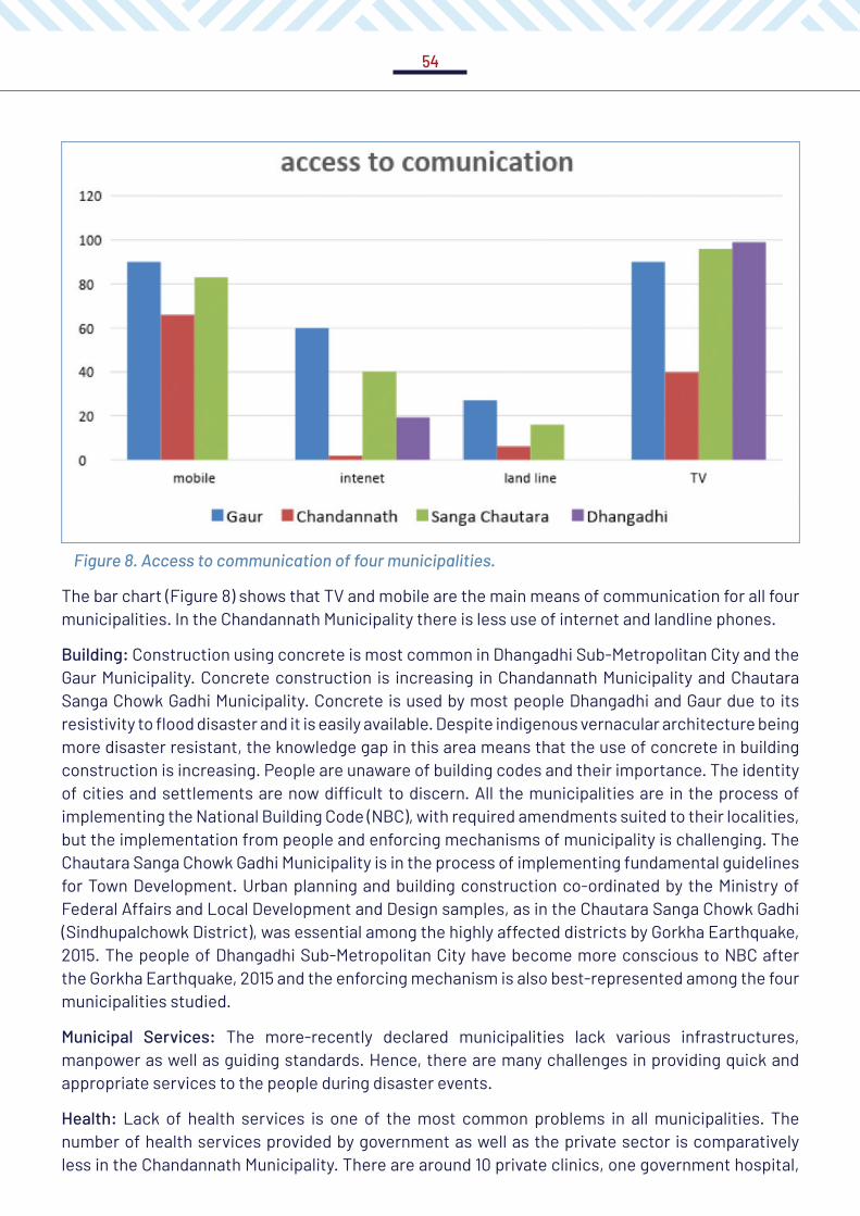
54
Figure 8. Access to communication of four municipalities.
The bar chart (Figure 8) shows that TV and mobile are the main means of communication for all four municipalities. In the Chandannath Municipality there is less use of internet and landline phones.
Building: Construction using concrete is most common in Dhangadhi Sub-Metropolitan City and the Gaur Municipality. Concrete construction is increasing in Chandannath Municipality and Chautara Sanga Chowk Gadhi Municipality. Concrete is used by most people Dhangadhi and Gaur due to its resistivity to flood disaster and it is easily available. Despite indigenous vernacular architecture being more disaster resistant, the knowledge gap in this area means that the use of concrete in building construction is increasing. People are unaware of building codes and their importance. The identity of cities and settlements are now difficult to discern. All the municipalities are in the process of implementing the National Building Code (NBC), with required amendments suited to their localities, but the implementation from people and enforcing mechanisms of municipality is challenging. The Chautara Sanga Chowk Gadhi Municipality is in the process of implementing fundamental guidelines for Town Development. Urban planning and building construction co-ordinated by the Ministry of Federal Affairs and Local Development and Design samples, as in the Chautara Sanga Chowk Gadhi (Sindhupalchowk District), was essential among the highly affected districts by Gorkha Earthquake, 2015. The people of Dhangadhi Sub-Metropolitan City have become more conscious to NBC after the Gorkha Earthquake, 2015 and the enforcing mechanism is also best-represented among the four municipalities studied.
Municipal Services: The more-recently declared municipalities lack various infrastructures, manpower as well as guiding standards. Hence, there are many challenges in providing quick and appropriate services to the people during disaster events.
Health: Lack of health services is one of the most common problems in all municipalities. The number of health services provided by government as well as the private sector is comparatively less in the Chandannath Municipality. There are around 10 private clinics, one government hospital,
55
three health posts, one academy of health science and few temporary health-service clinics. There is one government hospital recognized as a District Health Office, two Ayurvedic health centers and nine health posts in different governmental Wards. Similarly, there are 12 health facilities including two government hospitals and two health clinics while the remainder are private health services. Whereas, Dhangadhi Sub-Metropolitan City has largest number of health services. There are 16 health facilities including zonal hospital of Nepal Government, nine health posts and private hospitals. Health facilities do not seem to be sufficient in the cities. The government and private hospitals have been participating in disaster scenarios and actual situations. Hospitals of the Chautara Sanga Chowk Gadhi Municipality participated in response and relief during the 2015 Gorkha Earthquake and other disaster events in Sindhupalchowk District, whereas hospitals from the Gaur Municipality participated in response and relief during flood disasters occurring every year in Terai region. There was always shortage of medicines during response and relief activities.
Education: Dhangadhi Sub-Metropolitan City is a large city and also has the highest population among the four municipalities studied. It also has the highest number of academic institutions. There are more than 57 secondary level schools, of which 26 schools are government schools educating more than 13,000 students. The remaining private boarding schools have more students than the government schools. Similarly, there are around 5,000 students in seven schools (three government, one trust and three private) in the Gaur Municipality. There are eight secondary and higher level schools (six government and two private) in the Chandannath Municipality and 13 schools (12 government and one private) in the Chautara Sanga Chowk Gadi Municipality.
NGOs and the Private Sector: There are many sectors contributing to DRR in the four municipalities that were studied. They have been working in different phases of DRR cycle, such as mitigation, preparedness, response and recovery. The Non-Government Organizations (NGOs) namely FAYA, the Nepal Red Cross, Merci Corps, World Vision, Care Nepal, Sewak Nepal and CCS are active in Dhangadhi Sub-Metropolitan City. WFP, UNICEF, PAF, Nepal Red Cross, RDC-Nepal, Nepal Scout, OXFAM, Helpline Nepal, READ-Nepal are working in the Gaur Municipality. Rural Reconstruction Nepal, PACE Nepal and some other government organizations have been working in the Chandannath Municipality. And, WHO, UNICEF, WFP, USAID, World Vision, M.D.M. France are active in the Chautara Sanga Chowk Gadi Municipality. Apart from these organizations there are several programs from Government of Nepal in the field of health, hygiene and disaster resilient infrastructure construction. These organizations have been working in epidemic reduction, health, hygiene, food security, vaccination, skill development, capacity building, Water Sanitation and Hygiene, mason training and infrastructure development, education sector development, poverty alleviation, women and children development, gender and social sectors, human rights and assisting sectoral agencies for policy and planning.
After the local government elections, the initial decision made by the local bodies was that the agencies working on their territory should coordinate with the local bodies. Since then, the organizations have been seeking permission from local bodies and coordination with local bodies and report to them whenever they seek for information. Local bodies are lacking data and proper mapping, and technical capacity. NUDS, 2017 also highlighted that municipal database are very poor in Nepal and a system of regular updating and monitoring database needs to be institutionalized. Not only database administrators, but also local bodies need to be more empowered to coordinate planning, infrastructure and DRR, but this is currently challenging due to newly designated municipality and again newly reformed provincial government yet to be stabilized.◗
CHAPTER 7 : Conclusion
7.1 ConclusionEarthquakes, landslides, floods, climatic hot and cold waves and river inundations are major natural disasters in Nepalese Municipalities. Geo-hazards (landslide, debris flow and erosion) and human induced disaster (fire) are most frequent. Disasters related to hydrology and meteorology (drought, flood, cold waves and inundation) are very common. The impacts of those disasters are not just human losses, but also induce high economic and infrastructural losses. Organizations working in the area have been preparing maps for use in their projects. Amongst the several development activities, road construction, maintenance and upgrade, water supply and electric transmission have been main focuses. However, the mainstreaming of DRR into development activities has not been evident. The projects relating to sanitation and health are highlighted, but due to lack of public awareness and lack of regular maintenance, the success has been hard to achieve. DUDBC has been implementing the Integrated Urban Development Strategy in many municipalities. The Chautara Sanga Chowk Gadhi Municipality has been following Fundamental Guidelines for Settlement Development, Urban Planning and Building Construction Guidelines prepared by Ministry of Urban Development.
Some municipalities have some basic infrastructure to cope with environmental risks such as flood and waste disposal, whereas some are still preparing their plan for DRR mainstreaming. Lack of awareness, knowledge of risk-sensitive land-use planning, implementation of government plan and policies, and building code implementation are still major challenges. However, there are some positive DRR initiatives aimed at reducing environmental risk, such as safe community housing during floods, raised hand pump platforms, SAR training and the preparation of DDRMP and DDPRP. Involvement of youth, implementation of indigenous knowledge, fire brigades and DRR mainstreaming are important steps taken by the municipalities to reduce the effect of disasters, such as flood inundation, house-damage, water supply disruption and domestic violence.
Gender Equality and Social Inclusion (GESI) has become a consideration during planning and budgeting process Municipalities. For example, within two areas, the Gaur Municipality, a predominant Muslim community and the Dhangadhi Sub-Metropolitan City in which the Tharu community are more dominant, a specific plan has been implemented. Programs targeting specific groups (women, children, elderly people, disabled people, and marginalized communities) have been launched across many cities to support capacity development, income generation and public awareness. Although these programs are relaunched annually, the effectiveness of such programs is not yet evident. National Building Codes and Building by-laws are starting to gain weight in recent days. Many municipalities do not have up-to-date Building bylaws. Most who are implementing and enforcing Building bylaws are only operating in core areas. Currently, Building bylaws and Building Codes are not being followed because of the lack of awareness and poverty challenges. Since the local elections, there is hope for incorporating resilience in development activities.
7.2 Recommendations for ‘Entry Points’ to NURP1. Preparation of urban risk-sensitive land-use planning is a very important tool for urban
resilience, however few municipalities have such plans. Municipalities across Nepal are at different stages in terms of their awareness and understanding of DRR and that implementing risk-sensitive, land-use planning will need to be an incremental process. Some municipalities like Chautara Sanga Chowk Gadi are adopting more-advanced tools, whereas other municipalities may need to start off with data collection and awareness raising.

57
2. Earthquake training and mock drills can enhance institutional capacity for National Building Code implementation: Some municipalities such as Dhangadi have a clear vision about the National Building Code implementation and a commitment to implementing in urban areas. However, many municipalities are not able to effectively implement the National Building Code. For example, Chautara Sanga Chowk Gadi municipality was badly affected by the 2015 earthquake and did not manage to effectively enforce the National Building Code and Building bylaws in peripheral areas.
3. Municipalities should prepare bylaws suitable to their local context and conduct orientation programmes to raise awareness on the importance of following Building bylaws and the National Building Codes as well as planning bylaws. Municipalities need to provide some incentives for those who apply and implement these laws and codes. Specifically, municipalities located in the rural areas where women and poor marginalized groups who are socially excluded are densely located. When disaster hits, these groups of people are the most affected.
4. Multi-hazard risk assessment, that is probabilistic seismic-hazard assessment, flood-risk assessment, and landslide-risk assessment. Some hazard assessments have been sampled in the municipalities, however, they often neglect the links between different hazards which are highlighted in multi-hazard risk assessments. Risk assessment initiatives are very important in reducing the impact of disasters, their cascaded effects and likelihood.
5. Prevention and mitigation of frequent hazards, i.e. floods and landslides. There are very few initiatives or programmes which focus on the prevention and mitigation of different hazards, despite their high levels of impact. In the case of the Gaur Municipality, there are cases of international issues that require coordination between governments.
6. Preparation of Vulnerability and Capacity Assessment (VCA) of the municipality: VCA is always an important tool to understand the basic status of urban resilience in the municipality. None of the sampled municipalities have a VCA report. It is therefore important to understand those capacities and weakness within the municipality to formulate the urban resilience projects. Awareness and trainings on DRR and urban resilience are important steps for making cities more resilient.
7. Future DRR projects implementation should have proper and systematic mechanisms to disseminate information including the DRM Act so that the staff in the municipalities have an adequate understanding of such legislative/regulatory frameworks and the importance of mainstreaming GESI in DDR. Priority needs to be given to addressing the issues of women, children, PLWDs, the elderly people, the poor, the marginalized, and the Dalits during disasters.
8. Based on the analysis about vulnerability mapping in the four districts, it was revealed the three studied municipalities have an idea of their vulnerable populations but they have never carried out a vulnerability assessment and do not have data on vulnerability. The Dhangadhi Sub-Metropolitan City has started with the support of the Red Cross to conduct an Urban Vulnerability Assessment. Thus, it is highly recommended that future DRR projects carry out vulnerability assessments and develop a vulnerability database.
9. Future projects should give priority towards ensuring the infrastructures in the four municipalities are gender, PLWD and elderly friendly. This would require technical support
58
either centrally or externally including formation of simple guidelines as municipalities may not have technical capacity.
10. Except for Chandan Nath Municipality, the rest of the three Municipalities could not give specific details on the documentation of indigenous coping mechanisms. None of the Municipalities have a systematic documentation of indigenous coping mechanisms. Therefore, in the future, when implementing DRR programmes, priority should be given to documenting indigenous coping mechanisms in each of the Municipalities.
11. Every settlement must have traditional indigenous construction techniques which they have used to minimizise the disaster risk in the past, for example, the Chandannath Municipality used to tie lintels and joists as a single unit and build mud houses which design enhances resistance to earthquakes and snowfall. Similarly, the Gaur people construct wooden houses, raising the plinth so that when the area is flooded, it does not encroach on the living space. Thus to conserve vernacular buildings in different ecological regions, technical persons and local people need to be aware of simple retrofitting technology and measures that are needed to ensure adaptation to climate risks.
12. None of the four municipalities that were studied have a separate Section or Unit that deals with disasters. There is need for a separate Unit or Section, or at least one official with the knowledge on disaster who can handle activities related to DRM and DRR in the Municipalities. The focal person will on collect and disseminate information on disaster mainstream all the legislative and regulatory frameworks on disaster and build in a mechanism and institutional capacity to mainstream. The focal person will require training on DRR and DRM so that he or she can deal with disaster related issues in the municipality.
13. Include GESI in DRR and focus on addressing the issues of women, children, elderly people, PLWD, and the poor during times of disaster.
14. Mainstreaming GESI in DRR is a complex task, which requires all the organizations working in DRR to work in close coordination and learn from each other. With the above information collected in linkage/coordination, it seems that there is some level of coordination between the municipalities and the organizations working on DRR, however there is room for improvement and strengthening the coordination between them and different organizations working in DRR.
15. Municipalities require strategic intervention in DRR, to provide conceptual clarity on the importance of gender equality and social inclusion in DRR and the effects of disasters on women, children, elderly people, PLWD, the poor and the marginalized and how collective and coordinated efforts could address the issues of the vulnerable groups in times of disaster.
16. Although there seems to be some mechanism to disseminate information on disaster in municipalities, they do not have a systematic disaster information-management system. So, future DRR projects should give priority in developing a disaster information management system.
17. Municipal Plans should make provisions for DRR projects. Municipalities also should have a Municipal Transportation Management Plan, a Municipal Drainage Management Plan, building bylaws and planning bylaws incorporating also DRM and GESI components.

59
18. Support municipalities in urban planning to meet current and future needs of increasing urban population suiting to the likely demands of land and resources.
19. Map human resources in municipalities and consider what is missing to deliver resilient infrastructure, planning and service delivery.
20. Raise awareness and incentivize retrofitting of to abide by the Building code for non-compliant buildings.
21. Participation in planning process (such as community land use and risk mapping) to build links between communities and government as well as build capacity.
22. Consider the best means of collaboration between different stakeholders at local, regional and national scale in urban resilience, and how to support municipalities in their role in coordinating relevant projects and initiatives.
23. GESI indicators for each of the municipalities should be developed with proper mechanisms to monitor these indicators in resilience activities.
24. There is a need for thorough orientation on gender equality and social inclusion in disaster situations in Municipalities, not only to change the patriarchal mind-set of both the women and men in the Government structures, but also to create a more gender friendly working environment.◗