Embed Size (px)
Citation preview
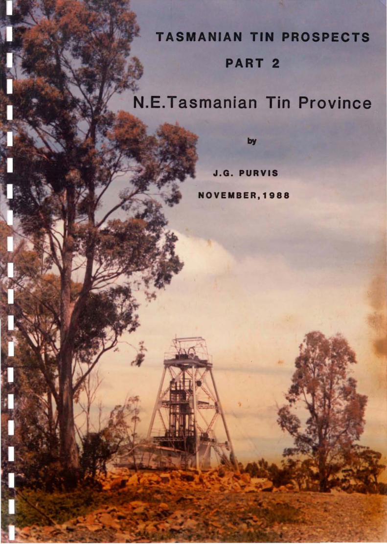
TASMANI
PART 2
N.E.Tasmanian Tin Province
J.G. PURVIS
NOVEIIBER.1 gaa

Cover: Headframe of Aberfoyle's Storeys Creek Mine.
TASMANIAN TIN PROSPECTS
PART 2 - N.E. TASMANIAN TIN PROVINCE
• PURVISJ. PURVIS & ASSOCIATESNOVEMBER 1988.
Submitted to:D. B. Wallace
DISTRIBUTION
Aberfoyle - Burnie (2 copies)Aberfoyle - Hawthorn (2 copies)
IIIIII·1IIIIIIIIIIIIII

CONTENTS
1. SUMMARY
2. INTROOO CTION
3. GEOL<X; I CAL SETTI&;
4
3
34
PlGE
1
5
6
7
AREAS 9
91518222832
LIST OF TABLES
NE Tasmanian Al~uvialTin Resources
Known Resources of the NE Tasmanian Tin Province
Production from NE Tasmanian Tin Province '
5.1 Anchor (and Blue Tier Tinfield)5 .2 Royal George5.3 Great Pyramid5.4 Aberfoyle - Storeys Creek5.5 Mt. Paris Mass5.6 Alluvials
5. DETAILS OF INDIVIIXJ AL PROSPECTS AND PROSPECTIVE
TABLE 2
TABLE 1
TABLE 3
4. TIN MINERALISATION
II.1III
"1.'
>' I
IIIIIIIIIIIII

IIIIIIIIIIIIIIIIIIIII
Figure 1
Figure 2
Figure 3
Figure 4
Figure 5
Figure 6
Figure 7
Figure 8
Figure 9
Figure 10
Figure 11
Figure 12
Figure 13
Figure 14
Figure 15
Figure 16
Figure 17
Figure 18
Figure 19
LIST OF FIGURES
Pre-Carboniferous Geology & Known Tin Potential, NE Tasman"a
Exploration Tenements N.E. Tasmania as at 2/12/88
Two Types of Alkali Granite Settings
Blue Tier Tin Occurrences
Anchor Mine Mineralisation, Alteration & Roof Structure
Blue Tier Area Geological Cross Sections
Cream Creek Area Blue Tier
Ben Lomond Granite Royal George & Other Old Mines &Prospects.
Royal George Mine - Cross Section
Royal George Mine - 4 Level showing Banded Nature of theOre Zone
Scamander District - Bedrock geology and mineralisationand zonal arrangement of mineral occurrences.
Great Pyramid Geology
Rossarden Area Geology
Aberfoyle Mine Area
Cross Section of the Aberfoyle Mine
Interpreted Cross-Section of the Ben Lomond Granite &Assoc. Contact Aureole along Storeys Creek to Aberfoyle& Lutwyche.
Geology Mt. Paris Mass
Mt. Paris Tin Workings - Diagrammatic Interpretation ofMineralisation Styles.
The Main Alluvial Tin Deposits of North-Eastern Tasmania.
III
II
-.:.··1_.
~I
IIIIIIIIIIIII
1.
1. SJMMAI«
The NE Tasmanian Tin Province has produced approximately 70,000 tonnesof tin - 46,500t from alluvials and 23,500t from hard-rock deposits.There is no current production.
In-situ identified resources, of varying reliability, total 39,500tonnes of tin. Total known potential resources (including theidentified resources) are put at 97,000 tonnes of tin. Although allidentified and potential resources are held by various Companies underRetention Licences or ELs, there is little activity at the presenttime.
The largest potential resource and what seems to be the best prospect,is at Aberfoyle (Rossarden) where large-scale open-cut bulk mining of themineralised Aberfoyle and Lutwyche vein swarms appears feasible. Thetotal potential resource here is estimated at a minimum of 40,000 tonnesof contained tin (+W03), with an indicated grade up to 0.25% Sn + W03and accessory Cu, Zn and Ag.
Another large open-cuttable resource is at the Great Pyramid depositwhere although the in-situ identified resource is only 3.13 milliontonnes @0.22% Sn (6,900t Sn), the potential resource has been estimatedby Aberfoyle (Young 1982) at up to 12 million tonnes @ 0.25% Sn (30,000tonnes of contained tin). This grade is understated by an unknownamount due to core losses during drilling and the true grade may be inexcess of 0.3% Sn.
Over 10,000 tonnes of tin is contained in identified alluvial resources,but no deposits individuallr exceed 2,000t Sn. A dredgeable potentialresource of 76.5 million m grading 103g Sn/m3 (7880t of contained tin),is estimated by Santos to exist in the Great Northern Plain area of theRingarooma valley. However, there are environmental and mineral tenureproblems associated with this area and the offshore deposit located onthe floor of Ringarooma Bay appears to be more attractive. Here
jthe
potential resource is estimated by eRA at a minimum 21 million mgrading 175g Sn/m3 (3700t Sn), but the deposit has not been fullydefined and may be much larger.
Other in-situ identified resources include the Anchor deposit at 3.51million tonnes @ 0.28% Sn (9700t Sn), including 634,000 tonnes @ 0.49%Sn (Renison figures). A small mining operation is planned at the Anchorby Spectrum Resources Ltd. commencing in early 1989. Spectrum have alsorecently taken up the Royal George deposit where there is an identifiedresource of 590,000 tonnes grading 0.41% Sn (CRA figures). Spectrumappear likely to try and acquire more tin properties in NE Tasmania.
The stanniferous alkali-granite intrusion known as the Mt. Paris Masshas excellent grassroots tin potential. Although the numerous workingson the mass have produced little tin, eroded mineralisation hascontributed over 27,000t Sn to the alluvial deposits in the Ringaroomasystem, making the Mt. Paris Mass the most productive tinfield in NETasmania. This fact has apparently not been appreciated by explorers todate - the area is under-explored and is not held under explorationtitle at the present time. The mineralised roof zone of the granite is

~~ ~~---- -~-~ ~~------------------------,------...,
2.
only partially exposed and eroded, with the southern half of theintrusion still covered by Paleozoic sediments. The inference from themassive amounts of tin shed from the eroded northern portion is thatextensive tin mineralisation should be present beneath this cover.Areas of thin cover are therefore prospective.
Tin mineralisation in NE Tasmania is genetically related to Devonianalkali-granite intrusions. Deposits are of three principal types :
1. Disseminated cassiterite in endogranitic greisen sheets and veins,associated with the roof zones of the alkali-granites.
2. Cassiterite in vein and fracture swarms in the SilUl:o-DevonianMathinna Beds sediments overlying the granites.
3. Alluvials derived from the erosion of the above.
The tin mineralisation in types 1 and 2 is often accompanied by tungsten(generally wolframite) and sulphides of Cu, Zn, Ag and As. Gangueminerals include quartz, topaz and fluorite.
The Mathinna Beds appear totally devoid of carbonates and there is noknown skarn-type tin mineralisation in NE Tasmania. There is somedevelopment of disseminated magnetite in the Mathinna Beds at the GreatPyramid deposit, which although minor is sufficient to cause a detectablemagnetic anomaly.
All deposit types are characterised by low overall tin grades, whichmakes them very dependent on the tin price for viability. This featureis to some extent offset by the simple metallurgy and bulk open-cutmining possibilities of most of the deposits.

liE. TASMANIATIN PROVf<olCE
LOCALITY MAP
Only resources in excess of2000 t Sn shown
GREAT NORTHERN PLAIN (Alluvial)Potential Resource' 7880 t Sn(76'5rnm 3 d) 103gm Sn/m 3 )
t. William
RINGAROOMA BAY· OFFSHORE (Alluvial)Potential Resource' 3700 t Sn(21-27 mm' <D 174 om Sn 1m3 )
, ,,, ,, ,,,,
Lomond Granite
ROYAL GEORGEIdentified Resource: 2400 t Sn(0'59 mmt 0:> 0·41 % 5n)Potential Resource: 3750tSn(O'75mmt 0:>0'5%5n)
BLU E TIERBATHOLITH
Little Mt. Horror
41 0 00' 5, , ,, , , , , ,.. , ,, , , , ,, , ,, , , , , ANCHOR,
Identified Resource: 9700t Sn,(3·51 mmt d) 0·28 % Sn J,
, , , Blue Tier Anchor Granite /.. Lattch Sheets), , , ,.. , ,. , , ,, , , , , ,, , , , , ,, , , ,GREAT PYRAMID, , , , ,Identified Resource: 6900tSn, , ,(3·13mmt d) 0'22%5n, ,, , , Potential Resource: 3O,()(X)tSn,.
Consta bles(J2mmt Ii) 0·25% Sn)
,. creek Scamonder
A8ERFOYlEIdentified Resource' 10,400t Sn tWO,(I·OBITITlT a) 0'9°/0 Sn +'NO,)" (0'223 romt cD 0·31'%,5n, 0·29% WO,)Potential Resource: 40,000 t Sn tWO,(I2mmt wO·lS%. Sn +WO,) .. ( 1·08 rom' d) 0-9% Sn+ WO, )
o () 20KmlI!'!!!!!!!!!!!!!!!!=__I
p~~.::=":} Alkali GraritB ('Tin Granite')
D Adamellite a Granodiorite
~ Mathinna Beds
.1
1
Aberfoyle Resources LimitedEXPLORATION DIVISION
NORTH EAST TASMAN IAPRE-CARBONIFEROUS GEOLOGY
KNOWN TIN POTENTIAL
REVISIONStnil. Dall Inil.
t location Code'
Dilli
As shown Decemtler, 1988
Compilld JG P
ofter liner,Drawn: a de Groof 1983
Tracld: RJE
Plall No. FIG.

PRomCTION FROM N.E. TASMANAN TIN PROVINCE(tonnes of tin metal)
HARD ROCK
TABLE 1
N.E. Alluvial Depositsa) Ringarooma River systemb) St. Helens area
3.
340
500
3,260
1,000
TOTAL
70,270
18,670
46,500
160
ALLUVIAL
44,5002,000
46,660
500
340
2,500600
1,000
23,610
17,800870
Anchor depositOthers
Aberfoyle/StoreysCreek DepositsOthersb)
a)b)
a)
Blue Tier Tinfield
Royal George Deposit.
Mt. Paris Tinfield
Rossarden Area
Totals
Great Pyramid Deposit
(Various Sources)
IIIIII
<IIIIIIIIIIIIIII

4.
TABLE 2
. KNOWN REsaJRCES OF THE H.E. TASMANIAN TIN PROVINCE(tonnes of contained tin metal)
HARD ROCK
IdentifiedResources
Great Northern PlainDelta/DugardsRingarooma Bay-offshoreArba Deep LeadCascade Deep LeadPioneer Deep LeadEndurance Deep LeadMonarch Deep Lead
7,8801,9303,725
13 ,535
TotalIdentified+ PotentiaResources
ALLUVIAL
1,9101,2351,0001,120
510
'4,190110
IdentifiedResources
10,075
Nil
9,700
3,750
30,000
83,450
40,000*
TotalIdentified+ PotentialResources
Nil
2,400
9,700
6,900
10,400*
29,400
Anchor deposit
Aberfoyle/LutwycheDeposits
a)
*Sn + W03
a)
Mt. Paris Tinfield
Blue Tier Tinfield
N.E. Alluvial Deposits
Royal George Deposit
Rossarden Area
a)b)c)d)e)f)g)h)
Totals
Great Pyramid Deposit
(Various Sources)
II
.oil~,.
:1
IIIIIIIIIIIII

Compiled: RJE
Drawn: RJE
Traced:
Checked JGP
Plate No FIG. 20".. December, 1988As shown
Aberfoyle Resources LimitedEXPLORATION DIVISION
NB. CORRECT AS AT 2/12/88
LOCALITY MAP
NORTH EAST TASMANIA
EXPLORATION TENEMENTSN. E. TAS MANIA AS AT 2/12/88
Scale
o 10 20 30 40 50 Kms
'l;;;;;;;......iI!'!!!!!!!!!!!!!!!!!!Ii.........ii!'!!!!!!!!!!!!!!!!li'......iiiiiiiiI'
Init. Date tnil. DateREVISIONS
location Code:
ROYAL GEORGE DEPOSIT
RingaraomaBoy
RINGAROOMA BAYOFFSHORE ALLWIALD£POSIT
'"•oooo::
N
E.L.NO. AREA Km 2 LICENCE HOLDER RENEWAL DATE
34/86 226 PLACECO (Au,l.) PL. 28/1/89
~ 43/87 200 8ACH HOLDINGS PL. a MINPROC P.L. 21/3/89
" r'48/87 94 TOTTENY PL. 21/1/89
i 31/88 i76/87 145 P. F. MINING SHELF (No.16) P. L. 21/5/8992/87 72 MINERAL HOLDINGS AUST. P. L. 28/10/89
. I 4/88 14 V. THREADER 18/8/89
I ' 5/ 88 4 SPECTRUM RESOURCES P.L. 11/ 7/89
L.._J 31/88 59 GOLDSEARCH LTD. 21/10/8942/88 25 NARGUN P. L. 7/ 11/8952/88 A LCASTON MINING N.L. PENDING
RL871 7 TRIAKO MINES N.L. a 8UKA MINERALS N.L. 8/3/91RL872 8 TRIAKO MINES N.L. a 8UKA MINERALS N.L. 8/ 3/91
RL8713 4 SPECTRUM RESOURCES P.L. 23/12190RL 8714 4 8HP CO. LTD. 8/3/91RL8715 6 HELLYER MG. a EXP. P. L. 30/5/93RL 8723 7 HELL YER MG. a EXP P.L. 30/5/93RL8808 3 . WHEAL LUTWYCHE PL. 25/11/91
5400 000 "'N
54~OOO,.N
,1

This report fulfills part of a commission to outline current tinprospects in Tasmania. Part 1 dealt with the Western Tasmanian TinProvince. This volume deals with prospects in the NE Tasmanian TinProvince.
11
<I
11
2. lNTRom CTlON
5.
I
1II11IIIII111
All the known unworked deposits, occurrences and geological environmentswith significant identifiable potential are listed. The report is notan exhaustive catalogue of all tin occurrences or prospects in NETasmania. Nor is there any attempt to assess the tin potential from anovertly geological or conceptual viewpoint.
The largest of the P?st producers not detailed in Section 5 are the St.Helens alluvial deposits (2000t Sn~and the Rex Hill Mine west ofRossarden (a greisen pipe in granite - 750t Sn, see Figure 8). Theformer have been well tested and shown to have little potential, whilethe latter appears worked out although there is no modern data on whichto base an informed opinion.
Considerable research has been undertaken in compiling the report inorder to get as an accurate a picture as possible, and to try andresolve the numerous inconsistencies and errors in some existing data.
Sections 3 and 4 of the report draw on data contained in the open filereport by L. de Graaf of the Shell Company's Research Group, entitled 'APreliminary Regional Assessment of the Granites and Tin Potential ofN.E. Tasmania' (1983). This is an excellent synthesis of the importantgeological aspects of the tin mineralisation.
The author has also drawn on various data, both published andunpublished, by N.J. Turner and P.L.F. Collins of the Tasmanian MinesDept.

The extent of the NE Tasmanian Tin Province is shown in Figure 1. Itswestern limit is defined by the NW-trending Tamar Fracture Zone whichdivides it from the Western Tasmanian Tin Province.
II111
3. GKOLa; leAL SKTTllC
6.
I
"·111II11I111I1I
The geology of NE Tasmania is dominated by Siluro-Devonian micaceousquartzwackes and mudstones of the Mathinna Beds, intruded by large UpperDevonian granite complexes. These rocks are unconformaly overlain byflat-lying Upper Carboniferous to Triassic sediments intruded by verylarge Triassic dolerite sheets. These rocks are in turn unconformablyoverlain by Tertiary and Quaternary fluvial terrestrial and marinesediments, particulaJly in the northern part of the area.
The principal granite complexes are the Blue Tier and ScottsdaleBatholiths. These are separated by a NW-trending belt of foldedMathinna Beds sediments. Both batholiths contain three main graniticphases - granodiorites, adamellites and alkali-granites. These are ofmulti-intrusive character and have been divided into a series of plutonsand sheets. The alkali-granites, with which the tin mineralisation isassociated, are the youngest of the granitic intrusives and have beendated at 364-374 my.
There are three principal intrusions of stanniferous alkali-granites:
the Lottah Sheets at Blue Tierthe Mt. Paris Massthe Ben Lomond Granite in the Rossarden-Royal George area.
The location of all alkali-granites is shown in Figure 1. These tingranites are confined to the upper levels in the batholiths and occupyabout 10% of their surface (Young 1979). Groves (1971) considered theyrepresent the low-volume residual liquids of the primary graniticmagmas.
The regional structural grain of both the Mathinna Beds and granites isNNW or NW and probably reflects deep-seated Paleozoic structurallineaments essentially parallel to the Tamar Fracture. This structuralgrain has influenced some control over the distribution of the tinmineralisation, both regionally and locally.

I
·,·,1"
III
IIIIIIIIIIIIII
7.
4 . TIN MINERALISATION
Tin mineralisation is associated with the alkali-granites and has beenattributed to the development, through extensive fractionation, of ahydrothermal fluid in which Sn, F and other incompatible elements wereconcentrated. Greisenisation occurred when this late melt, located nearthe roof zone of the granite body, lost equilibrium with earlier formed(higher temperature) minerals (Taylor 1980 - see Bibliography 5.1).
These hydrothermal fluids tended to 'pond' in 'traps' at or close to theflat-lying upper contact of the alkali-granite intrusion, particularlyin cupolas or other structural highs and irregularities. Here theyformed flat-lying sheets or steeply-dipping veins and loaes ofendogranitic mineraLised greisen. Some greisens formed at the contactof alkali-granite and Mathinna Beds sediments (as in the Mt. ParisMass), others at the contact of alkali-granite and barren earliergranitic phases (as in the Blue Tier Tinfield). See Figure 3.
Clearly, the shape of the alkali-granite roof zone was a major control onthe tin mineralisation. Definition of the original granite topographyis an important part of exploration for greisen-style mineralisation.
In NE Tasmania the greisens are markedly limited in depth, and generallythe bulk of alteration and mineralisation lies within 50 metres of theupper alkali-granite contact. The steeply-dipping structure-hostedgreisen body at the Royal George Mine is a notable exception, with thegreisen extending to a depth of over 200m. Generally greisenisationextends to greater depth than the tin mineralisation.
This depth-dependence of the tin mineralisation also has importantexploration connotations. Once the alkali-granites are unroofed thehigher grade tin mineralisation risks being quickly eroded. The mostprospective zones are obviously those close to, or still shallowlycovered by, the overlying Mathinna Beds or barren earlier granites.
The greisens are characterised by granular-textured quartz-muscovitetourmaline-topaz-fluorite-sulphides-cassiterite. The principalalteration types being silicification and sericitisation. In thestrongest greisen zones some secondary carbonate is often present generally siderite or ankerite.,
The greisens have elevated Si02 and Fe contents. Elevated traceelements include F, Li, Rb, Nb, Sn, W, Cu, As, Zn and Ag. Of these, Sn,W, Cu, Zn and Ag are likely to be of economic significance. Greisensare depleted in Ba, Sr, Zr and Y. U levels average around 23 ppm whichis anomalous but not unusual for tin granites.
From an exploration viewpoint, areas with tin potential within thealkali-granites can be recognised by low Ba/Rb «0.2) and high Rb/Sr (>20) ratios, distinctly elevated F and Li contents, and anomalous totalgamma radiation. At the Anchor Mine, Renison (Cartwright 1983 - seeBibliography 5.1), showed that Ga and Rb are significantly enriched andCa depleted, in the barren adamellite within 100m of mineralisation in
III'III
-I"1IIIIIIIIIIIII
8.
the underlying alkali-granite. Occurrences of accessory topaz and/ortourmaline are also important indicators of differentiated/mineralisedgranites.
The styles of tin mineralisation can be summarised as follows :
1. Endogranitic flat-lying or steeply-dipping tabular sheets ofgreisen with disseminated cassiterite and sulphides, occurring inthe roof zones of alkali-granites.
2. Quartz or quartz-greisen veins, generally thin and steeply-dipping,hosted by alkali-granite and containing coarse-grained cassiterite,sulphides + wolframite.
3. Quartz-cassiterite-sulphide ~wolframite vein swarms in MathinnaBeds sediments overlying alkali-granite.
4. Alluvial and elluvial cassiterite deposits in Tertiary andQuaternary sediments.
The various styles of tin mineralisation are well illustrated in thefigures in Section 5. See also Figure 3.
The greisenised zones in the alkali-granites are often surrounded byhaloes of argillic alteration containing tin values in the range of 1001000 ppm Sn. This soft argillised granite was extensively sluiced bythe old miners. It also readily decomposed to form 'elluvial' deposits.Much of the so-called nard-rock' mining on the Blue Tier and Mt. Paristinfields was of this type.
No sulphide-hosted tin mineralisation of the type found in the WesternTasmanian Tin Province occurs in NE Tasmania. The Mathinna Beds aredevoid of carbonate lithologies and no skarn development is known.Minor disseminated magnetite, sufficient to cause a detectable magneticanomaly, is present in the Mathinna Beds hosting the Great Pyramiddeposit and is considered due to metasomatic alterat'ion around thepostulated underlying granite.

= TYPES OF l\LKALI GRANITE SEl'I'INGS
fa) Contact of roof zone alkali::::qran.ite withsedi..Irents .
Volatile bUild up in cupola causes hydraulicfracturing of sediments •
.. .... +
..•
+•.. •
•.. +
.., •
..• 1.
Sn mineralisation fontlS in veins in overlyingsediments; and in greisen sheets and veins/lodes,in the host granite.
Pegmatitelenses
••
+• ,
..•
,•
++
L_.:.'__.:.'__''--_.:.''--_-'.'----' 2 .
,'.x X X X X
.< X X X X(b) Contact of roof zone alkali:<rranite with older
barren granite.
x
•,
,
•
x
,
x
,
x
x
,
x
+
x
,
x
x
•,
x
..x
1.
Roof zones of granite rocks frequently fonn avery tight seal. Volatile build-up willextensively alter the fractionated top ofalkali-granite as it will "stew" in a mixtureof water, HF, HCI, etc. for a protractedperiod of time, resulting in extensivegreisenisation. Sn-mineralisation is mainlyconfined to these "sheets" of greisens.
.. .. .. .. ~ ...
Pegmatitelenses
2.
M:xlified fran de Graaf(1983)
B SEDIMENTARY' ROCKS
B UNDIFFERENTIATED GRANITES
S ALKALI GRANITES
1-.":::·::1 VOLATILES AND GREISENS
Aberfoyle Resources LimitedEXPLORATION DIVISION
AEV1SIoIIISIIlil. Dill 1.11. 0111
TWO TYPES OF ALKALI 0,1•• : after de Groof,l9B3
GRANITE SETTINGS YIn": RJE
Sull : NTS 0111 : Decembe r, 1988
Chell": JGP
II
:::1~> .';
IIII
",I
IIIIII
····1..
IIIIII
9.
5 • DETAILS OF INDIVIllJ AI. PROSPECTS AND PROSPECTIVE AREAS
Areas and deposits considered to have significant tin potential aredetailed in this section. They are not presented in order of merit.Figures relating to each prospect are located at the end of therespective sub-section.
5.1 ANCHOR(and Blue Tier Tinfield)
LOCATION: The Anchor tin deposit is located 22 km NW of St. Helens,near the east coast of Tasmania. It lies in steeply dissected forestedcountry 4 km from tae Tasman Highway linking Launceston and St. Helens.
TENORE: The deposit is covered by a 4 sq km Retention Licence (No.8713) held by Spectrum Resources Pty. Ltd., whose stated intention is tocommence m1n1ng the deposit early in 1989. The surrounding area,comprising most of the old Blue Tier Tinfield, is vacant ground atpresent.
STYLE OF MINERALISATION: Cassiterite is irregularly distributed asfine-medium grained erratic disseminations (no veins), within the roofzone of an alkali-granite sheet where it contacts an overlying older,barren porphyritic adamellite. The mineralisation is associated withpervasive alteration (greisenisation) of the alkali-granite caused bythe 'ponding' of late-magmatic and hydrothermal fluids beneathstructural irregularities in the roof zone. The intensity ofmineralisation and greisenation decreases with depth and is largelyconfined to the upper 30-40 m of the roof zone. Not all the greisencarries tin. Very minor amounts of sulphides are present (cp, sp,molybdenite) as well as wolframite and silver.
The mineralisation is located in a flat-lying zone 750m long and 100200m wide, trending NE from the old open cut. Using a cut-off of 0.2% Snthe mineralisation resolves itself into two lenses : A Lens lies NE ofthe old open cut, in the apical region of the alkali-granite roof (seeFigure 5). It is accompanied by intense alteration and the host granitehas been converted to a granular quartz-topaz-muscovite greisen. B Lensmineralisation lies slightly below A Lens, adjacent to a structurallycomplex area of the granite roof in the east face of the old open cut.B Lens is hosted by less intensely altered greisenised granite.
Overall, the key elements of the mineralisation are its low grade anderratic distribution.
GEOLOGY: The Anchor deposit is part of the Blue Tier Tinfield, a seriesof tin occurrences within granites of the Upper Devonian Blue TierBatholith. Two granite phases are present : an older coarse grained,porphyritic biotite adamellite (the Poimena Pluton), which is intruded

IIIIII
IIIIIIIIIIIIII
10.
and underlain by flat-lying sheets of medium grained, equigranularmuscovite-biotite alkali-granite (the Lottah Sheets). At the Anchor,tin mineralisation occurs in the roof zones of the younger intrusive,known locally as the Anchor Granite.
In the deposit area a microgranitic phase associated with the PoimenaAdamellite is present in places along the contact with the alkaligranite. The contact itself is marked by the sporadic development of" aflat-lying thin pegmatite zone (see Figure 6). The adamellite andmicrogranite are strongly oxidised to depths of 20m+. The Anchordeposit is cut by the major NW-trending Crystal Creek Lineament whichappears to have been a control on mineralisation and structure, both atthe Anchor and elsewhere in the Blue Tier Tinfield (Roberts 1982).
EXPLORATION AND MINING HISTORY: The Blue Tier Tinfield has a historyof intermittent alluvial and lode tin production, mainly in the period1870-1920. The Anchor deposit was discovered in 1881 and recordedproduction from 1890-1942 is 2360 tonnes of tin from open-cutoperations, mostly by the Anchor Tin Mining Company which produced 2590tonnes of tin concentrates from 1.32 million tonnes of ore (a recoveredgrade of 0.14% Sn). The old open cut covers 5 ha, measures 380m NE-SEand averages 120m in width. The Anchor accounted for an estimated 80% oftotal lode tin production from the Blue Tier Tinfield.
Since mining stopped in 1942, significant exploration at the Anchor hasbeen carried out by Aberfoyle Tin Development Partnership (1963-66), andRenison-Goldfields (1977-84). Aberfoyle drilled 39 diamond drill holesand delineated four flat-lying zones of mineralisation. They calculatedthe resource at 1.99 million tonnes @ 0.32% Sn.
Renisons work was continuous and comprehensive. They set out to definea large-tonnage low-grade open-cut table deposit at the Anchor. BetweenOctober 1977 and June 1981 Renison conducted five diamond drillingprogrammes totalling 81 holes. They also carried out metallurgicaltesting, geochemical and petrological studies, resource calculations andfeasibility studies.
Initially, the Renison programme was successful. In January 1980 anIndicative Feasibility Study showed that reserves of 2.5 million [email protected]% Sn would support a viable mining operation. This figure wasachieved by further drilling during 1980 when 'possible ore reserves'were calculated at 2.5 million tonnes @ 0.4% Sn using a 0.2% Sn cut-off.
However, a programme of in-fill drilling and bulk sampling formetallurgical testing, conducted between November 1980 and June 1981,demonstrated a lack of continuity of the mineralisation in key areas andsignificant differences between (higher) grade estimates based ondrilling, and those (lower) based on metallurgical bulk samples from thesame locations. The metallurgical testing itself indicated tinrecoveries of +80% were feasible.

II
····1..
11.
The severely-downgraded resource calculation at the completion of thein-fill drilling (634,000 tonnes @ 0.49% Sn, at 0.2% Sn cut-off), didnot approach the objective of the Definitive Feasibility Study soRenison suspended work on the Anchor and switched the emphasis totesting other prospects on the Blue Tier Tinfield. Here, their bestresult from 43 holes on at least 8 prospect areas was definition of anestimated 110,000 tonnes @ 0.4% Sn at the Moon prospect, 3 km north ofthe Anchor. Renison ceased exploration in 1984.
"POSSIBLE ORE' -
IIII
REswaCE:as follows
1.
Renisons final resource calculations (Ross 1981), were
at 0.2% Sn cut-off:
IA LensB Lens
425,500 tonnes @0.51% Sn208,500 tonnes @0.45% Sn
I Total: 634,000 tonnes @ 0.49% Sn(3100 tonnes of
contained tin)
I 2. 'ADDITIONAL ORE POTENTIAL' (mineralisation peripheral to abovelenses) at 0.1% Sn cut-off:
I2.88 million tonnes @ 0.23% Sn (6600 tonnes of contained tin).
I3. 'TOTAL POSSIBLE & POTENTIAL ORE': 3.51 million tonnes @0.28%Sn
(9700 tonnes of contained tin)
Although not specified, the resource also contains approximately 8 g/tAg, 100 ppm Cu, 200 ppm Zn and 17 ppm U.
POTENTIAL: The apparent lack of continuity of the mineralisation asoutlined by Renisons infill drilling, and the marked decrease in gradein the PQ metallurgical holes as against the NQ-BQ exploration holes,raises concerns as to the reliability of Renisons quoted resourcefigures.
Assuming production prior to 1943 of 2500 tonnes of tin and recoveriesof about 70%, the total ore mined from the Anchor to date can beestimated at around 1.6 million tonnes grading 0.23% Sn. Combining thiswith Renison's "Possible and Potential Ore' figure at 0.1% Sn cut-off,gives an ORIGINAL RESOURCE ESTIMATE of 5 MILLION TONNES @0.26% SN(13,500 tonnes of contained tin).
8.8 million tonnes @ 0.18% Sn (15,800 tonnes of contained tin).
at 0.05% Sn cut-off:'TOTAL POTENTIAL RESOURCE'4.
I
I
II
II
II
There is a clear inference that the quoted grade figures may beoverstated and that closer-spaced and larger-diameter drilling could seea reduction in the overall resource grade.
I
IIIIII
·:1IIIII
12.
Certainly, the early drilling seems to have been too small diameter (BQ)and the holes too widely spaced, to be really reliable. The drillingwas not systematic with the spacing between holes after the infilldrilling varying between 15 and 60m with most around 30-40m. In someareas there is an obvious need for the pattern to be closed up.
Because of the open drill pattern, there is undoubtedly some limitedpotential for additional tonnage of economic mineralisation in theimmediate Anchor area - as acknowledged by Ross (1981).
While the indicated resource at the Anchor may be sufficient for aviable small open-cut operation at the current tin price(A$ll,OOO/tonne), the erratic distribution and overall lo~ grade of themineralisatibn means- careful grade control and selective mining will berequired.
NOTES ON THE BillE TIER TINFIELD
When the Anchor is excluded, the Blue Tier Tinfield was a very smallproducer with total recorded production from hard-rock sources of around600 tonnes of tin (Ross 1978). However, the numerous tin prospects inmany cases represent the eroded remnants of originally more-extensivemineralisation (see below), and the detrital cassiterite so-formed hascontributed at least 13,000 tonnes of tin to the extensive alluvialdeposits in the Ringarooma River system to the north of the Blue Tier(see Section 5.6).
The mineralisation within the tinfield (in every case, cassiterite withminor sulphides and wolframite), falls into three main styles:I
III
1.
2.
3.
Floor (or Roof) deposits: flat-lying greisens of Anchor Type. (e.g.Moon, Michael).
Vein deposits: quartz or quartz-greisens veins, which occur mainlyin the stanniferous alkali~granite but can also occur as ~eakage'
in the older adamellite where it overlies mineralised alkaligranite (e.g. Lottah Tunnels, FB Lode).
Dyke deposits: erratic, steeply-dipping mineralised bodies inalkali-granite dykes. (e.g. Southern Cross).
IIIII
Only the floor deposits are attractive exploration targets and offer thepossibility for the development of large-tonnage low-grade deposits.
From 1978-84, Renison carried out mapping, geochemical surveys anddrilling on the Blue Tier Tinfield. They also made use oflithogeochemistry to define prospective areas following orientationsurveys at the Anchor which showed that Ga and Rb are significantlyenriched, and Ca depleted, in the Poimena Adamellite within 100m ofmineralised alkali-granite (Cartwright 1983). They also made use of thepattern of enrichment of Rb, Sn and Cu within the upper and marginalareas of the alkali-granite (Cartwright 1982).
II
III
IIIIIIIII
13.
Renison were able to construct structural contours which showed that thestanniferous alkali-granite intrusive underlying the tinfield has theform of an irregularly-shaped, steep-sided ovoid body with a flattishbut highly irregular upper surface. Mineralised greisens formed beneathcupolas, domes and ridges, on the upper surfaces and steep flanks of theintrusion. The Anchor deposit and Moon prospect are examples of flanksituated greisens.
However, the Renison work also showed that at the present exposure levelmost of the upper-surface traps and their greisens have been erodedaway, leaving only remnants. Cartwright (1982) concluded that thepossibility of uneroded or buried greisens at the top of ~he intrusionwould appear to have been exhausted by Renisons work, and thatshallowly-buried flank-traps in the more geochemically anomalous Eastand North-east areas of the alkali-granite were the most promisingremaining targets.
It was beyond the scope of Renison's exploration programme toexhaustively test the potential for buried greisens on the Blue Tier.Although their work has restricted the prospective area, possibilitiesfor flank-trap deposits of Anchor style remain.
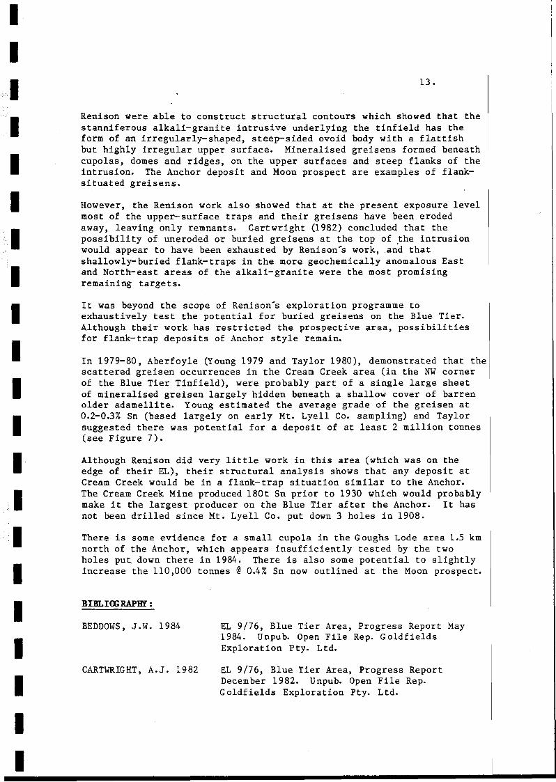
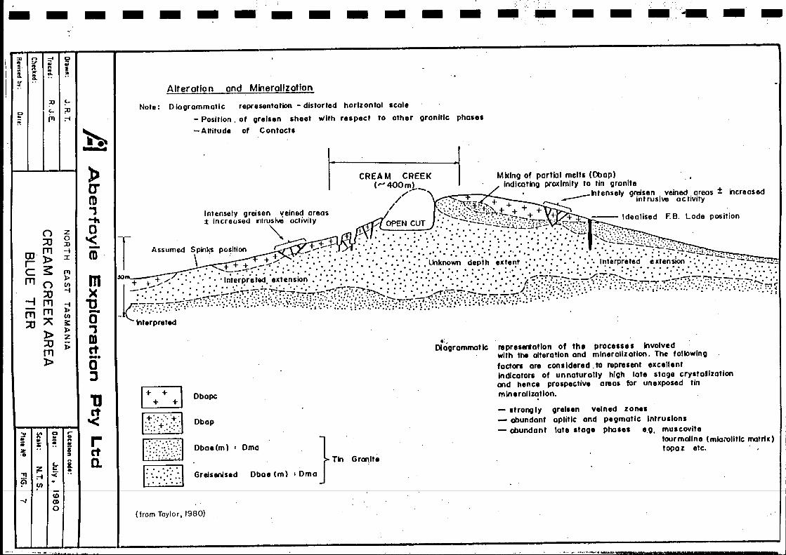
In 1979-80, Aberfoyle (Young 1979 and Taylor 1980), demonstrated that thescattered greisen occurrences in the Cream Creek area (in the NW cornerof the Blue Tier Tinfield), were probably part of a single large sheetof mineralised greisen largely hidden beneath a shallow cover of barrenolder adamellite. Young estimated the average grade of the greisen at0.2-0.3% Sn (based largely on early Mt. Lyell Co. sampling) and Taylorsuggested there was potential for a deposit of at least 2 million tonnes(see Figure 7).
Although Renison did very little work in this area (which was on theedge of their EL), their structural analysis shows that any deposit atCream Creek would be in a flank-trap situation similar to the Anchor.The Cream Creek Mine produced 180t Sn prior to 1930 which would probablymake it the largest producer on the Blue Tier after the Anchor. It hasnot been drilled since Mt. Lyell Co. put down 3 holes in 1908.
There is some evidence for a small cupola in the Goughs Lode area 1.5 kmnorth of the Anchor, which appears insufficiently tested by the twoholes put down there in 1984. There is also some potential to slightlyincrease the 110,000 tonnes @0.4% Sn now outlined at the Moon prospect.
IIIII
BIBLI<x; RAPHl :
BEDDOWS, J.W. 1984
CARTWRIGHT, A.J. 1982
EL 9/76, Blue Tier Area, Progress Report May1984. Unpub. Open File Rep. GoldfieldsExploration Pty. Ltd.
EL 9/76, Blue Tier Area, Progress ReportDecem ber 1982. Unpub. Open File Rep.Goldfields Exploration Pty. Ltd.

II
·1IIIIIIIIII1IIIIIII
CARTWRIGHT, A.J. 1983
GROVES, D. 1. 1977COCKER, J.D.JENNIN:;S, D.J.
NEWNHAM, L.A. 1977
NEWNHAM, L.A. 1980
ROBERTS, P.A. 1982
ROSS, A. 1978
ROSS, A. 1980
ROSS, A. 1980
ROSS, A. 1981
ROSS, A. 1981
TAYLOR, J.R. 1980
YOUN:;, C.H. 1979
14.
EL 9/76, Blue Tier Area, Progress ReportDecember 1983. Unpub. Open File Rep.Goldfields Exploration Pty. Ltd.
The Blue Tier Batholith.Geol. Survey Bull. No. 55, Tas. Dept. of Mines.
Summary Report on Blue Tier Tin Prospect, EL9/76. Unpub. Open File Rep. Renison Ltd.
Proposal for the Further Evaluation of EL 9/76,Blue Tier, Tasmania.Unpub. Open File Rep. Renison Ltd.
EL 9/76, Blue Tier Area, Progress Report.Unpub. Open File Rep. Renison Ltd.
EL 9/76, Blue Tier Area, Annual Report 1977-78.Unpub. Open File Rep. Renison Ltd.
EL 9/76, Blue Tier Area, Eastern Tasmania, 1979Annual Report. Unpub. Open File Rep. RenisonLtd.
EL 9/76, Blue Tier Area, Eastern Tasmania,Progress Report. Unpub. Open File Rep. RenisonLtd.
EL 9/76, Blue Tier Area, North East Tasmania.Geological Report on Bulk Sampling at theAnchor Deposit. Unpub. Open File Rep. RenisonLtd.
EL 9/76, Blue Tier Area, North East Tasmania.Geological Report on the Anchor Tin Deposit atthe Completion of Infill Diamond Drilling.Unpub. Open File Rep. Renison Ltd.
Weldborough EL 19/78, Report for the Year EndedAugust 9th, 1980. Unpub. Open File Rep.Aberfoyle Exploration Pty. Ltd.
Progress Report, EL 19/78 Weldborough, August20th, 1979. Unpub. Open File Rep. AberfoyleExploration Pty. Ltd.
-- .. _ ..
. .
..
.' .
. . .. .Tin Occurrltlc.
Adom.lIiteD·. ...
"- >. -.'.." '.0,
. . . . . . . . . ....... . . . . . . . . . . . . . . ."+'" • • • . . • . • . . • . . • •.... I' . • • • • • • • • • • • • ...... .• ,oJ • • ,_~ •• •••••• ,
• • • • • • • • • • • • • .. I .. . • • . . . . . . • . • . \ + . . •· :-:-:-:-:-:-:-:-:-:-:-:-:·:-t + + ) ••••••.•••.••••••••••••••••.•••.'. '0". ",' ',. ,"+ + l. :-:-:-:-:-:-: -: -:':-:-:- ......•·.. '. . j + ~.' ••••••••••••••••••••••••••••••••••••••••• '. •..~ 1····'++ -"' .• .Creom Cr••k • • • , '/ ;,. ••••••••••••••••••••••••• r ••• '1+ +"', + + .
• • •• • • • • • • • • J' + '. . • . • • • . • • • • . • . . • . . • •• • \ fI ••••••••• ., + .. ·.·f + + \ ••••••••••••••••••••••••••• .. ••.••••••• + \ • • • . . • • • . . • . . • • • • . • • .• • )J• ••••••••• 1+ " + + ~r.·.·.·.·.·.· .• • • . • • • • • . • • .• + +l·. + + + ..•....•••••.••••••. ....." .
•·.·.·.·.·.·.·.·.·.·.·.·.·.f++\.• ' ++.1 ..••....•....•....•.•.••••••.•••.....•....••.••••..•...····· ······l +"+ 1 ,••••• &-.'i'(. •••••• + .' + + ._ •.••••••••••••••••••••.••••••••.•••• ~ -~ •••• \+,......L+\\+..0i I ,• ......+ + I:>t ••• '..l ... :"' .... ~. • Michael •••••••••••• • • • • • • • • • •• • •••••••• • • •• \ + ~...., +... :-. • 't- , '. • • • • • • • • • • • • • • • • • • • • • • •••...... , t~·····"" ,\ , .
•••.••.•••.••' + ·.h·.·.·.· ,{ + - J' io.. + + 1 .• ••••• \ ~ 16' •••• ,+ +. 1.·1..~ + ., •••••••••••••••••••••••••••••••••••• •••..• \ \...... + '+ " + + ••••••••••••••••••••••••• • • • • • •• • ••• '."":: ".... ..._ ...." •••••••••••• T •••••••••• , •• T ;_ ......· .qj . . .. ":'",+"'1 •• •\+, •••••••.•••••••••••••• , •.~ + " •
:::::::::::::::~:.:::::::::::::.:.:.:.:.:.~l.:.~........ :::::::::::::::::::::::::::::::;~ -+ ++ + + ~.\• • • • • • • • • • • • • • '.~'.'.'.'.' ~.' • Moon ••••••••••• •••• / + + + + t··:-:-:-:-:-:-:-:-:·:-:·.:-:.v "t).·.·.·:\ I~ .•..... :-',:-:-:-:-:««-:-:-:-:'4- + + +f•. . . . . . . . . . . . .\ (' . . .,. _ ~ I + + + f• • • • • •• • • • • •• '1 " •••• ',' ... T __ ••••••• " ' •
• • • • • • • • • ~ +("'" . • •••,'. I'.. + + -_.•••• tr + + + + ~ .•••••••••• "' + )........~......:. '~Southern Cross.;...,;.. + + "".·.·.·.f + + + ... +(.'••••••••••• " + + +... ,. 'Th'. , X _ ... _ ....1 ••• + + + + +~ ..•...•• \ _ •.. +++;,.-:.: -: -:·:-:i +-+ + + +~+":-. :-:-:~ LoUoh Tunnels 1:-.·.·.·.: + + + + 1:-:-
• •••• ~ + + oS! T • •••••••••••••••••• T + + + + 1.·r • • • • • • • • • • • • • • • • • • • .,·....••... ' + + + I. . ., " . . . • • . . . . 1 + + + + + I·.· .• • •1 r. ,J •••••••• , + + + + •· •.. '. . • + + + ••.•••••••••••••••.• "y-· •..••, + + + .....•••••.•..•• '.' .. , + + + + + \• • • • • • /Of' • •• ....• •• '. + ,o,.1. •••••4'l.j.. 'OI ••••••• f + + + + +,..
, •• '01 ...... - I········,· ..' ... ' .•.• \ +. + ',.'. Gough, Lodes.................... + + + + + ~.'• •• , iO'o + •••• , ••••••••••.1 + + + +_ + I .
, • • • •• '01 •••••••••• ,+ + "+ + I" ......· .. , .,+ + + '.' ... ••••••••• /. J • ~. ,,..... I' +.- ........ •.. ~+ ++-t".;.+/.... ... •• I~ /., •••••••••• "'; ... + + ( ...... ::t.- + i' . • -: '~=-.( •· "* '~~;'.' ~~• • • • • • • • • • ....... • ..... T
• • • • • • • I. ....• , Cr sial. Hill ""./ + +•. '. • . . • • ..•.... . . I + + +
. • • • • • • •• Anchor· "/ + + + +.•....•. '.\+++++
...............• \.++++. . . . . . . .\ +........-t++++
.............. ,+ + + + + +.•••••••••.••. ~ + + + + + + r.· ....•......... r- + + + + + -fI,•••••..... -/+++++'+""' ••
• • • • • ·f + + +, + + + + \.•.••••:-:-:-:-: ~\.+ + + + of + + ++-lo.-+.-./-:- ...••..• • . . • , '(" + .+ +... "."l'"................. ..' .. ~-"",-."":'"'.'.'.'.'.'.'.'.'.'.'.'.,.. . . .. '~.; ..
. '. ~..
Arias with occurrences of alkali grOtli'l
Aberfoyle Resources LimitedEXPLORATION DIVISION
1~~t'R"'VCISI'jO.N"s~~~l c"c"~:N:O:R;T:H~E~A:s:T~"T~Ais;M~A:N:';A==C" J:cl·~m~P1i1~·d~'"~G.. ,P;"""~;~'~3~,l 1.i1 0'" 1.i1 0'" TJNB~~~u~~:NCES ::::.:,.....G'"'fl981
lilutilln Call.: SuI. 1:75000 D.", Noysmber, 1988 Pbfl Nil.' FIG 4

•
"."
•
•
1
•
•..•~
:::,~
• ~
"'"••E~
"
\•
- "--.- \\\
/ {I~II
" I JI I r
( \
•
" " , ,- ," ,,
" \
•
z~
Q. >-o "o u~
o
.j:
'1/
· i~ -.· /.
'. 1. / ..'j'
. I '
•
-'. ;- .~.---. ". -.-.--
~J
I .1'. / J./
/. j•-j' /,'. I: /
<'7'>::-.. "1'--+.~...:/•· /.' r r. ' . .j" /
II
• •
--.,, ,,···
•
•
•
",'.•
z•o••
•
--
'io~;:: '"Q?tu~l!i~ 0:., .,
--~ ~0/ ~ § ~
/ .......... _ "~ C)\/'/ 'VI\
/ //./ \ ~ g \/ //,.- '<{~ \
.- ....-<.;/'.,. \ lJj -' \--- ././'}' ••••• :>, Q:~
,Y./, 1" ••• '" \.. i/~Vl-.., \-/.. /y \,
:./"/" ...•... 1 :'" 1\'./ I . . . . . .. - :':" \ I \........ '. .. Y·. \ I '.l . T"
.\. 'J' ....\ "./. " \ -. . i" '>.1. . ..........
"
Aberfoyle Resources LimitedEXPLORATION DIVISION
•
•
" ," " "",,,
"
•
• / • ",I I
~~I'I •/
I II IIr \\
,• ",
" ~
•
REVISIONSInil, D.u lnil. Oil'
NORTH EAST TASMANIA Compil.c1 : J. G. Purvis
ANCHOR MINEMINERALISATION, ALTERATION a ROOF
STRUCTURE
O"wn 'after Ross I 1981
Trine! ,
Chlehd :
1 loution Cod, ' Sui. , I: 1400 0.1. : November, 1988 PI.I. No.: FIG 5

.•
W ESCHEMATIC SECTION THROUGH THE ALKALI GRANITE
SHOWING STYLES AND POSITIONS OF TIN MINERALISATION,
ridges prOducing windowsand dykes
~VEINSTYLE 9
ALKALI GRANITENOT TO SCALE
e.g.ANCHORDEPOSI
ofter Cartwrioht, 1982
NW ,• SE
•o
.+++
+
+
++
+
, .. . ' .'';:."::''';''':''":..'::.,.:+,.: +"
.. ' .'. : .. ' . '(9:" '+' "::~':'.'.. +': :.~'.'." :":+' .~~<
T' •• •... . . '. . . ....... , '... . ..o
'. +VEIN-:' .HINXL •.
+.f.POIHENA ADAHELLfTE
2.HICROGRANITE
3-ANCHOR GRANITE
4"HIN£RALlS£D ALT~RED ZONE
s:s:.E. STANNIFEROf/S ZON£
I
~... -...~. •. ·w.. +'+ •..'.. '., . .
+
ofter Ross, 1981CONCEPTUAL DIAGRAMMATIC SECTIONTHROUGH ANCHOR MINE AREA
Aberfoyle Resources LimitedEXPLORATION DIVISION
A1VlSlOHSI"il. 0.11 I"il. Du.
NORTH EAST TASMANIA
BLUE TIE.R AREA
GEOLOGICAL CROSS SECTIONS
O"WII:
S~II. ; not to scole 0.11 ,November, 1988 PI," /Ilo. : FIG 6
- - - - - - _. - - - - - - - - - - •..~- - -:D
gl~la..a· ~ ~ u.. ... .. I... .. ... ..!f
Q. .. o.
I;:0 ~
~I I~;u;-i
b......
Alteration and Mineralization
Note: Oloorommotic representation - distorted horizontal scale
- Position. of orelsen sheet with respect to other granItic phases
-Altitude of Contacts
CREAM CREEK I Mbclng or partlol meltl (Dbap)(""400mj..-. Indicating proxlmitv to tin granite .•//. __kltensely g~sen . veined. qreos ± increased
/ :.;'.::':,,:,:\:;0::;: :>. + + ~ intruSive actIVItyIntensely greisen ,!eined areas 'S-~.::::::-: -:t~A.+ + + +T"M--.-"'"± Increased I1lrusi\.ta activity / OPEN CUT .:. ~~"':::".:::;~·~·:.:~I?::?~~.•: . ..,.~,...,. --- Idealised F.B. Lode position
T"" + + :-. :...... '. ::.~ ...:::.::-:-:-:.::~.~:~:~.~::::/?~~~ ;~t:~.::::~>~~:.:.::::.:: ..
Assumed Spinks position ~ +_ .....~ '. : .••• '" .. " ••• ' .' •. ' •• '.:.' '. -'-'':'':''~:':':.,::,'.. + ~ .:.7':. ::: .: :':. ': : :.:. :.:. -:" ..,:.: :. ':.. .:.: :'.' :':" ::::'.: ~. :-'. : ::....: .. :- .:.... :·:::'~:fY.f/;';:,:,:",f":":":::":~"" .
\. + + + . '" '. . . '. ..' '.. . ... lXlknown depth extent '. •••• • Interpreted extension·'· •...~jQ •• : •••• ::.~-;-;'"-::-::::.;": '::.':.:': '., •• :.:: ••••• :.:.:.:•• :.: ••:.:.;.:•••••••~::.;.:••• ::..';. •• :: •• : ••• ::::.:.:•••• :.:.::•.••••• : •• : •••• -:::-:
+ +"!:-~ '. Interpreted extensIOn. '. ••••• •• '., • '.' •• ' •• .'. ~~ .. ";--.-._-:'/' ... 1'7-~' .' • '-"-":':'1- " '.'
J2i;:.:;:.:.:;.;,:.~~Hf,t!t;i;'.t:0hixidIj.;2;~{0:t&M;;;~.;:;18;:j;si[.;i,~;::j?:{)iiY<·,\:\';':.;'.' r';,.:.;;;; ,;:;;,Y)'::/'·:;y.·;·:C'!;:.T'i:i. ;:.;.~klt.rpreted
Oboe 1m ) lOrna
(from Taylo r, 1980)
n1presentatlon of the procelSes Involvedwith the olteratlon ond mlnerallz arion. The followingradors are conlldered. to reprelent excellentIndicators of unnaturallv high late stage crystallzatlonand hence prospective area5 for unexposed tinmineralization.
grelsen veined zoneloplitlc and peomaflc Intrullonslate Itooe phales e.o. muscovite
tourmaline I mloiOlltic matrix)topaz etc.
- Itronglv- abundant- abundant
_:
OIogrammot Ie
Gr~lt.
}
Tin
Oboe 1m) lOrna
Obap
Grelunlsed
Dbapcr++I~
EBJt:.,'.>:-t:·..... +","..... : .' ...
~~
E2J." '.-....... ".' .....
net'<retc.
»0"m,....o'<-mm)(
1]-a.,mct-.a:J
n z0::u :n
rn -itD» :r
~~ rtl):.
rnn l/)
::u -i
-I rn -i- rn»rn " ~:0 »» z
:0 »rn»
~I~a r-.. a.. .. :; n. .- !tz .. ii.. ..
z 1:- i,.. I' -< •_ ;-i
(i) (I)
-./I~0
............. ,.,.._....'t'~,
.,.1
1
.111111111111111I11
15 .
5.2 ROYAL GEOlGE
LOCATION: The Royal George tin deposit is located 15 km ESE ofAvoca in eastern Tasmania. Access is excellent, with the deposit lyingon a low sparsely-forested hill about 1 km from the Avoca-Swansea road.
TENURE: The deposit is covered by recently-granted EL 5/88 of 4 sq. kmbelonging to Spectrum Resources Ltd., a small New Zealand-basedexplorer. About 30% of the known deposit, and its possible NWextensions, lie on private land where there is disagreement between theDepartment of Mines and the landowner regarding mineral rights. However,the landowner has a~ways supported exploration of the property.
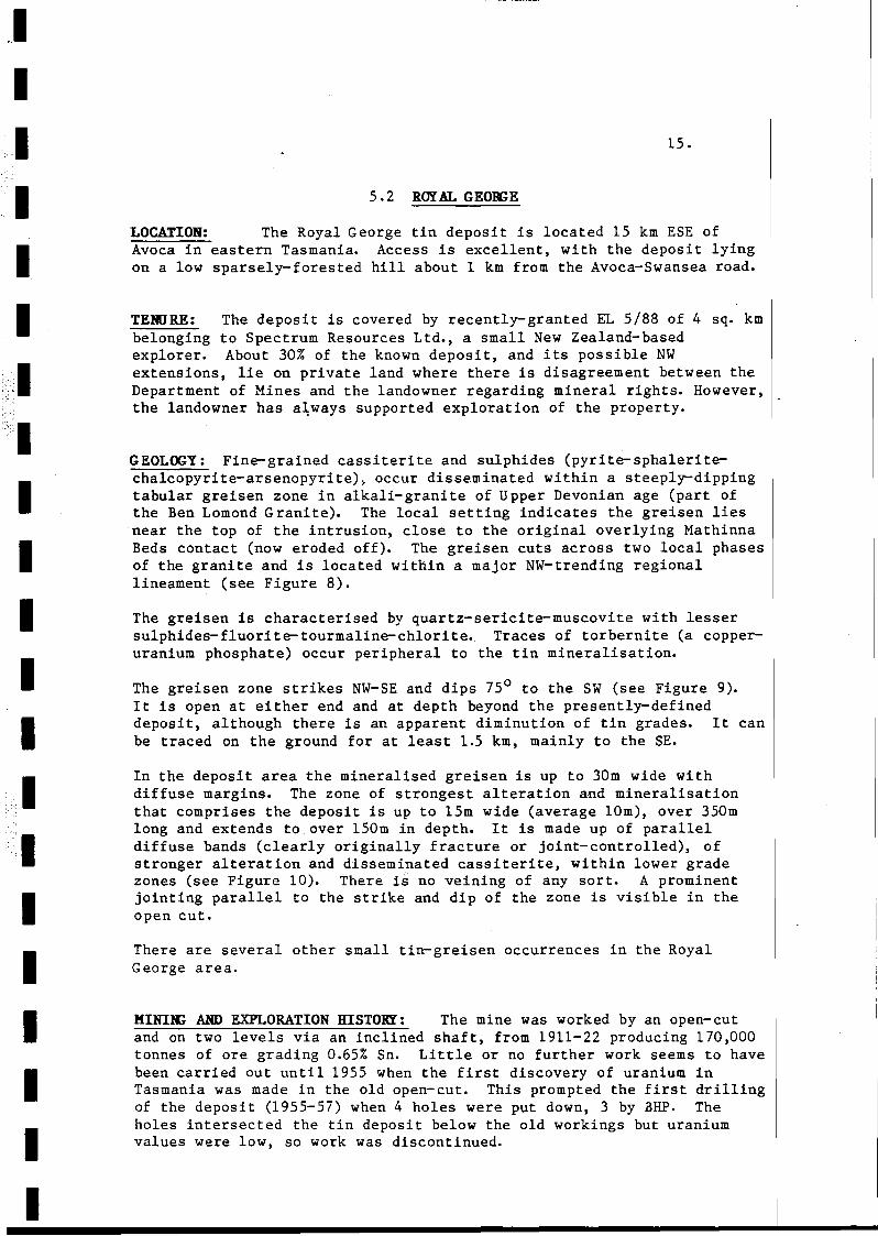
GEOLOGY: Fine-grained cassiterite and sulphides (pyrite-sphaleritechalcopyrite-arsenopyrite), occur disseminated within a steeply-dippingtabular greisen zone in alkali-granite of Upper Devonian age (part ofthe Ben Lomond Granite). The local setting indicates the greisen liesnear the top of the intrusion, close to the original overlying MathinnaBeds contact (now eroded off). The greisen cuts across two local phasesof the granite and is located within a major NW-trending regionallineament (see Figure 8).
The greisen is characterised by quartz-sericite-muscovite with lessersulphides-fluorite-tourmaline-chlorite. Traces of torbernite (a copperuranium phosphate) occur peripheral to the tin mineralisation.
The greisen zone strikes NW-SE and dips 75 0 to the SW (see Figure 9).It is open at either end and at depth beyond the presently-defineddeposit, although there is an apparent diminution of tin grades. It canbe traced on the ground for at least 1.5 km, mainly to the SEe
In the deposit area the mineralised greisen is up to 30m wide withdiffuse margins. The zone of strongest alteration and mineralisationthat comprises the deposit is up to 15m wide (average 10m), over 350mlong and extends to over 150m in depth. It is made up of paralleldiffuse bands (clearly originally fracture or joint-controlled), ofstronger alteration and disseminated cassiterite, within lower gradezones (see Figure 10). There is no veining of any sort. A prominentjointing parallel to the strike and dip of the zone is visible in theopen cut.
There are several other small tin-greisen occurrences in the RoyalGeorge area.
KINIle AND EXPLORATION HISTORY: The mine was worked by an open-cutand on two levels via an inclined shaft, from 1911-22 producing 170,000tonnes of ore grading 0.65% Sn. Little or no further work seems to havebeen carried out until 1955 when the first discovery of uranium inTasmania was made in the old open-cut. This prompted the first drillingof the deposit (1955-57) when 4 holes were put down, 3 by BHP. Theholes intersected the tin deposit below the old workings but uraniumvalues were low, so work was discontinued.
II
IIIIIIIIIIIIIIIII
----------------------...,......-----
16.
From 1965-71 the Cornwall Coal Co. conducted a systematic explorationprogramme aimed at proving up the deposit. They drilled 13 new diamonddrill holes, deepened the inclined shaft and drove No. 3 and 4 levels.They took underground channel and bulk samples, did preliminarymetallurgical testing and established the grade of the old tailings.
From 1979-82 CRA, in a JV with Cornwall Coal thoroughly evaluated the.property, resampled the old drill core and redefined the resource. Theydrilled one hole to test the depth extent of the deposit which showedthat although the greisen zone extended below 200m from surface the tinvalues declined markedly. CRA conducted metallurgical tests on the ore,did surface exploration along the trend of the Royal George greisenbearing structure an~ examined the smaller prospects in the area.
After CRAs withdrawal Cornwall Coal Joint Ventured the deposit andsurrounding area to Amax (1983), and Shell (1984-85). Neither of theseparties did any work at Royal George itself. Cornwall Coal finallyrelinquished the area in 1986. Spectrums recent pegging signalsrenewed interest in the deposit.
RESOURCE: In 1967, the Tasmanian Mines Department (Noldart 1967),calculated 'indicated and probable reserves' on the basis of theCornwall Coal and earlier drilling, at 161,600 tonnes @0.61% Sn.
On the basis of the resampling of the 18 drill holes and undergroundchannel sampling, CRA (Purvis 1979) calculated 'reserves' using a 0.25%Sn cut-off, as 590,000 tonnes @ 0.41% Sn, 12 g/t Ag and 0.21% Zn (2400tonnes of contained tin). The resource lies in a 350m long zone between30m and 170m below surface.
Because of the small core size (Ax and Ex) and core losses in the morefriable mineralised zones, Purvis considered the resource could beunderstated by as much as 25% in both tonnage and grade, giving apotential resource of 750,000 tonnes @ 0.5% Sn (3750' tonnes of containedtin).
Combining mined ore with the calculated resource, gives an ORIGINALRESOURCE ESTIMATE of 760,000 TONNES @ 0.46% SN (3500 tonnes of containedtin). .-
POTENTIAL: Royal George is one of the strongest of the NE Tasmaniantin greisen systems and probably ranks second only to the Anchor Mine.The mineralised greisen is remarkable for its regularity, strength anddepth extent. The Royal George greisen marks a major regional lineamentwhich undoubtedly has further potential for tin mineralisation.
The deposit itself and its immediate environs have never been properlytested and there is some scope for the discovery of additional ore. Aspointed out by Purvis (1979 & 1981), the small diameter of the existingdrill holes and the substantial core losses within the mineralisedintersections, mean the present resource grades are wholly unreliableand probably considerably understated. Because of the banded highgrade/ low-grade/high-grade nature of the mineralised zone, any increasein grade of individual bands would also lead to an increase in tonnes asperipheral bands became economic and the mineable width increased.

II.1IIIIIIIIIIIIIIIIII
17.
While the indicated deposit size «1 million tonnes), and grade (0.40.5% Sn), is modest, the good rock conditions and simple metallurgy ofthe ore are factors which suggest a profitable small-scale miningoperation may be feasible at Royal George at current tin prices($A11,000/tonne).
BIBLla;RAPHY :
de GRAAF, L. 1983 Regional Study of the Ben Lomond Granite.Unpub. Open File Rep. Shell Co. of Aust.
NOLDART, A.J. 1967 Royal George Tin Mine, Cornwall Coal Company.~as. Department of Mines, Tech. Report No. 12. p24-27.
PURVIS, J.G. 1979 Initial Exploration at the Royal George Tin Mine,EL7/78, N.E. Tasmania.Unpub. Open File Rep. CRAE.
PURVIS, J.G. 1981 Final Report on Exploration at the Old Royal GeorgeTin Mine, EL7/78, N.E. Tasmania.
Unpub. Open File Rep. CRAE.
VIVIAN, R.M. 1983 Final Report on Exploration Activities within EL7/78, Royal George, Amax/Cornwall Coal Joint Venture.Unpub. Open File Rep. Amax Aust.
WHITAKER, A. 1985 EL 7/78 - Royal George. Progress Report onExploration for the Period 14/7/84 to 14/7/85.Unpub. Open File Rep. BilUton Australia.
WHITAKER, A. 1985 EL 7/78 - Royal George. Progress Report onExploration for the Period 14/7/84 to 13/12/85.Final Report. Unpub. Open File Rep. BillitonAustralia.

- ... Faull (and 11"0_)
//
//
/
/
Rall_oy
Ben Lomond Granll',
Matl'llnna B.d'
B'n lDmond Sn'Gt. R,p"blic
Main road
Main Sn Pra,pectl
Abondon,dMin'
REVISIONSInit. 0," Init. n,11
Aberfoyle Resources LimitedEXPLORATION DIVISION
NORTH EAST TASMANIA Campillll :J.G.Purvis
BEN LOMOND GRANITE
OVAL GEORGEaOTHER OLD MINES a PROSPECTS!-"",''':::''-'--------lCIMckl4 :
Sull : A, shown 0'11 : November. 19BB

LEGEt~D
Altered ~jo it, ,ranit,with tourrn lint
Mi neroliltd tr"dvrClor '9rtl"n' "n4'
'G . J'r,ilt",It" 3Dn, Dr
oecDI/ion,,1 ',reiStn' b"nd'.. ithin tht 9r"nit,
Traced:
Drawn: after Purvis, 1981
Clmpilld: J 3P
+
+
G
//
//
IU./(1(10'
,..V,4WES
IIII
Aberfoyle Resources LimitedEXPLORATION DIVISION
N.E
NORTH EAST TASMA NIA
I II II II II I
• I II II I/
II II /
I 0 N'lUYELI/ II II I/ II ZONE OF I
/ I/ BEST rlN II // I
II//I/
,~'I /, I I'+r '
, ~O II I ~ I I
" I, • + I C
,i.j I I ,~ I1 • I c,;.. I1,9, -:.. ,
I, 1++ N'~~lFY(L "I ~ + ~ II Ol~~ ~ /' GI ~~ + J ,I + /'l1i
II ~\O JI II , ~,. \I ,)\"' I !~O
I 1 / £.0.11.35'I / A~/>roI. Zj' C.
I I
G
DateREVISIONS
Init. Date In it.
G
-------
ROYAL GEORGE MINE
CROSS SECTION1 t--+--+---+----t Clleckld :11---'---....L...--.....L...---+-------------,-----------+-------+-----11 Location Code: Scale : I" = 50' I DatI: Decerrber, 1988 Plate No.: FIG 9
11,1I1IIIIII1IIIIIII·1
uo
lOa' .sOUTH x CuT
$0' :lOUTH X CUT
II\I •\ .\\I\\\\\\II\\\\\
\\\\\\\
\\\I
11!)· (N/,..)
111111,.pr.S"
I, I, \" .. \" 0 \, \
""'~'~~"~~~'~'''':''~--r~''-----7---'----'''''.....im- hi"\ \\ \I I\ \\ I\ I\ \\ \\ \\\\\\\III\\II\\I
""',.•i ....tt .
".prt. IiJ.ti'"r ........... ,G"t. . hi!' '" .
••••••• St.... ,I'::1 'ulpoh"liC ~9,t; .."·
•• "hJI~<ltll~ ·9'11111.".<1' ,"1~Jo,,;;c yo".tl
39 C..Q.J..E. fOtn,rC tit prliiua ':"50
............... CIl_.1 ,,,..,It
TO'" Ti....Iu• ;., ,p"', (JU",!' 10,- .LooJ.I)
li S.,••~ lU''';
\\\,,
\\\
Aberfoyle Resources LimitedEXPLORATION DIVISION
NORTH EAST TASMANIAREYISIONS
III't. 011. lllit. 0.11
ROYAL GEORGE MINECllm,il.. , JGP
011.11 'after Purvis, 19BI
4 LEVEL
SClr, ; I, 200
SHOWING BANDED NATURETHE ORE ZONE
011., December, 1968
OF Tru'" ,
PI," N•. , FIG 10

II
IIIIIIIIII
IIIIII
18.
5 .3 GHEAT PYRAMID
LOCATION: The Great Pyramid tin deposit outcrops in hilly forestedcountry 7 km NW of Scamander, on the east coast of Tasmania. Forestrytracks provide good access.
TENORE: The property is held by BHP under Retention Licence RL8714 of 4 sq km, valid until March 1991.
STYLE OF MINERALISATION: In the deposit, tin occurs as cassiteritein close-spaced parallel joints or fractures only 1-5 mm wide, withincompetent quartzites of the Siluro-Devonian Mathinna Beds. There is aclose correlation between fracture density (at )90/m) and the bettergrade mineralisation, which averages around 0.2-0.25% Sn. The fracturesdip steeply and are oriented normal to a local NW - trending fold axis.They are lined with quartz, cassiterite, siderite or sulphides(principally arsenopyrite-pyrite-chalcopyrite). The cassiterite isgenerally )100 microns in size. The deposit is oxidised to depths of70m and the tenor of the mineralisation decreases below this depth.
GEOLOGY: The host Mathinna Beds silicified quartzose sandstones("quartzites") and shales are folded but essentially unmetamorphosed.The fractures and mineralisation are almost entirely restricted to thesteeply-dipping quartzites. A major NW - trending fault with steepnortherly dip transects the prospect. The deposit lies 4 km SE ofadamellites and granodiorites of the Upper Devonian Mt. Pierson Plutonwhich marks the southernmost extension of the Blue Tier Batholith.
The mineralisation is apparently genetically linked to the intrusion ofMt. Pierson Pluton. There are numerous small mineralised occurrencesfor W, Mo, Sn, .Bi, Pb, Zn, Cu, Ag in the Scamander district around theGreat Pyramid deposit, which reflect mineral zoning around the pluton(see Figure 11). Magnetic anomalies in the Mathinna Beds in the depositarea are due to disseminated magnetite, considered related to themetasomatic aureole about a postulated high level granite intrusivebeneath.
EXPLORATION HISTORY: The deposit was discovered in 1909.Exploratory driving and shaft sinking was undertaken up to 1914, andfrom 1925-36 3 tonnes of tin was produced from 336 tonnes of ore(equivalent to a head grade of 1.5% Sn) - the only production to datefrom the deposit.
Since 1964 the property has been the subject of several systematicexploration programmes, involving the drilling of 163 percussion and23 diamond drill holes, by BHP (1964-65); Aberfoyle Tin DevelopmentPartnership (1969-74); Tasmanian Mines Department (1976-80); and BHP(1980-81). The property has been inactive since Shell withdrew from aJV with BHP in 1986.
II
I
19.
Great Pyramid was evaluated by C. H. Young andK. G. Palmer of Aberfoylein 1979 and again by Young in 1982. The author evaluated the propertyfor CRA in 1979.
RESOURCE: Several calculations have been made of the tin resourceat Great Pyramid by various parties using differing methods. Most ofthese calculations involve depth limits of 70m below surface (150m RL)and cut-offs of 0.1%Sn. The figures can be categorized as "In-SituIndicated Resources' and their reliability is questionable due tosampling problems (discussed in the next section - see below) •
The calculations are :...1~I ::
"
::'1 Assessment By In-Situ Indicated Resource(@ 0.1% cut-off, to 70m depth)
Contained Tin
I1I
Paringa/Aberfoyle(1969-74) 4.1 mmt @0.31% Sn 12,700 tBHP (1981) 4.1 mmt @0.22% Sn 9,000 tBHP (1981) 3.3 mmt @0.26% Sn 8,600 tShell (1983) 2.8 mmt @0.225% Sn 6,300 tShell (1984) 3.13 mmt @0.22% Sn 6,900 t
(@ 0.2% cut-off, to 70m depth):Shell (1984 ) 0.306 mmt @0.46% Sn (South Block) 1,400 t
(The resource also contains 2-6 g/t Ag).
The North and South blocks are essentially the one mineralised zoneslightly offset by the major fault.
The Shell calculations by Wright & Hall (1984) are the most detailed andcomprehensive. They separated the resource into 3 blocks (see Figure12):
1I
;::1I1
NORTH BLOCK. SaJ TH BLOCK
BROCKS BLOCK
TOTAL
897,300t @0.19% Sn1,980,200t @0.24% Sn252,700t @0.17% Sn
3,130,200t @0.22% Sn
IIIII
POTENTIAL: The feature that most affects the potential of the GreatPyramid deposit is the general absence of zones of high grademineralisation. Using a 0.2% Sn cut-off to try and assess the potentialfor higher grade zones, the best Shell could do was 306,000 t @ 0.46% Snin South Block close to a cross-cutting diorite dyke where there isincreased fracturing and mineralisation (Wright & Hall 1984). Selectivemining appears impossible ~oung 1982), and ore sorting tests initiated

II
IIIIIIIIIIIIII
20.
by Aberfoyle in 1979 were a failure. On the positive side, the depositoutcrops on ridges and the steep topography would assist open cutmining.
A second feature that impinges on the potential of the deposit is thethe unreliability of the drilling results. Although much of thedrilling was at spacings of only 20-30m, almost all assessments of theproperty agree the drill results are probably significantly understated.
Wright & Hall (1984) state : "From investig~tions made by BHP on sludgeassays from diamond drilling, it is apparent that diamond drillingundervalues the grade, but this cannot be quantified". The BHP studyindicated that the tin values in core were undervalued by up to 30% dueto losses to sludge,from poor recoveries, but Craigie (1983) in astatistical study showed that "grades from the percussion holes are 4050% higher than for the diamond holes". There is also no correlationbetween tin grades in percussion holes and adjacent diamond holes.
Young (1982), considered the mineralisation had not been adequatelytested because none of the drill holes and adits had tested at rightangles to the mineralised fractures. In fact, some holes were orientedparallel to the fractures. Young states : "There is reasonable optimismfor grade improvement should adequate testing be done normal to thefracture direction. However, it is unlikely that a major change ingrade would eventuate".
All the above suggest the present calculations understate the grade ofthe deposit and that its true grade may be in excess of 0.3% Sn.
There is also potential to increase the tonneage. BHP (1981) estimatedthere was at least 4.2 mmt grading 0.16% Sn of 'potential ore' adjacentto the outlined resource. Young (1982) estimated 'total potentialreserves' to 140 m below surface at 12 mmt @ 0.2 - 0.25% Sn (cut-offunknown). This suggests the deposit could contain up to 30,000 tonnes oftin.
There is potential for buried tin deposits in the vicinity of GreatPyramid and these could be of sheeted greisen type similar to the Anchordeposit, or further occurrences of fracture-controlled Great Pyramidstyle mineralisation, as postulated by BHP. The grade of such targetswill only be economic if they are close to surface, and the indicationsfrom BHPs exploration of the surrounding area are that this is not thecase. There also appears to be a lack of suitable criteria by whichtarget areas for such buried deposits might be selected. Young gavethis reason for declining BHP's JV invitation on the property in 1982,
BIBLI<X;RAPHf :
IIII
CRAIG IE R. C. 1983 Great Pyramid Tin Prospect.1. Statistical Study of Drill hole Data.2. Estimation of Ore Reserves.Unpub. Rep. Shell Australia Metals Div.

II
IIIIIIIIIIIIIIII
GROVES D. r. 1972
JACK R. 1963
PALMER K.G. 1979
WRIGHT D. 1984HALL D.B.
Y<lH{; C.H. 1982
21.
The Zoned Mineral Deposits of the Scamander St. Helens District. GeoL Surv. Bull. No. 53.
Great Pyramid Tin Mine, Upper Scamander.Tas. Dept. of Mines Tech. Reps No.8. pp25-45.
Great Pyramid "Ore Reserves". Unpub. AberfoyleMemo, 11th October, 1979.
Great Pyramid, NE Tasmania. PreliminaryResource Calculation 1983-84.Unpub. Rep. Shell Australia Meta~s Div.
Great Pyramid, North East Tasmania. Unpub.Aberfoyle Exploration Property Examination Rep.plus attachments.

,:••<
!•,••
I••
••e~~•
·i j•
•··i
•~,,~•
)~• .<· .- < •••
•
•t•••,•;;•<e•
\
•-~e••• •
~ OJ
:! ::• ,• •i,E
+
+
+
+
+
+
+
+
+
+
+
++
+
•,--i-----t_~_.
+
+
++
++
a:woz<::!<U111
..ua:..111oo
z<
'"Uoa:owIII
zo'<NoJ<a:wz::!
>..,ooJoW..,
D.O.WI.Trfeld :
Cheeked'
PI.II No.: FIG II
D"wn :otter Ol.Gfo¥es 1975
COlllpild : J.G. Purvis
DUI: NovtrTlber, 1988
DISTRICTmineralisation andmineral occurrences
Aberfoyle Resources LimitedEXPLORATION DIVISION
NORTH EAST TASMANIA
SCAMANDERBedrock geology andzonol arrangemenf of
Sea!.: As shown."'-__.c..:.;,;;_---'-.;:.:...:,.---'-'----'----'--'-__......J
REVISIONShlil. Oil' tllil. DIU
1 LOtll;on Code:
"•.!!"0~•c'f
o
enQ)...-Q)
Eoo
Claeck.d :
Trac.d :
Cempil.d: J. G Purvis
Drawn : ofter Shell
NORTH EAST TASMANIA
GREAT PYRAMIDGEOLOGY
Aberfoyle Resources LimitedEXPLORATION DIVISION
DaleREVISIONS
10it. Date Inll
1 i---~-I------!----15 i---'---L----''-11 ..... .••.,__,.L<;.;a:.:-~~, _:~_~~~n Da_te_:_N_o_ve_rn_b_e_r,_19_88 ......PI_It._N_e._:_~__-'
IIIIIIIIIIIIIIIIIIIII

II
IIII
IIIIIIIIIIIII
22.
5 .4 ABERFOYLE - STOREY S CREEK
LOCATION: The old Aberfoyle and Storeys Creek mines lie 13 and 16kms respectively north of Avoca in eastern Tasmania. The mines wereserviced by the township of Rossarden - now in decline.
TENURE: The immediate Aberfoyle Mine area is covered by a RetentionLicence of 3 sq. km. held by Wheal Lutwyche Pty. Ltd. (RL 8808). The Sto eysCreek Mine and the ground around Aberfoyle is currently up for tender.The area SW of the Aberfoyle Mine is the subject of an EL application byAlcaston Mining NL (ELA 52/88).
MINIM; HISTORY: The Storeys Creek Mine operated intermittently for100 years - from 1881 to 1981. The Aberfoyle Mine was worked from 1931to 1982. Together, the mines produced approximately 17,800 tonnes oftin metal and 13,000 tonnes of W03• Ninety percent of the tinproduction was from the Aberfoyle Mine.
The mines were operated by Aberfoyle Tin Limited, who sold them in May1981 to Rossarden Mines Ltd. (a member of the Bond Group of Companies),with the economic mine reserves exhausted at Storeys Creek and rapidlyapproaching exhaustion at the Aberfoyle Mine. Operations ceased inApril 1982 when the Aberfoyle Mine finally ran out of viable reserves.Rossarden Mines carried out a very limited programme of ineffectiveexploration before quitting the area in late 1982.
GEOLOGY: The mineralised vein systems are hosted by quartzosesandstones (quartzites), siltstones and shales of the Siluro-DevonianMathinna Beds. The sediments have been subjected to weak regionalmetamorphism, strike NW and are tightly folded.
The Mathinna Beds are intruded by the Upper Devonian Ben Lomond Granite- a porphyritic alkali-granite. The granite roof is gently E-dippingand is pierced by several late-stage aplitic apophyses which project upto 100m above the granite as a series of flat-topped, steep-sided domesor cupolas elongated N to NW (see Figures 15 & 16). These apliticapophyses are genetically resporisible for the mineralised vein systemsin the sediments directly above.
The granite was unroofed in the mid Carboniferous to early Permian andflat-lying Permian shallow fresh-water conglomerate, siltstone and shalewas deposited on both granite and Mathinna Beds. In the Aberfoyle Minearea these sediments cover the southern part of the mineralised veinsystem and are up to 18m thick.
MINERALISATION: Three major cassiterite-wolframite-sulphide quartzvein systems were worked: the Aberfoyle and Lutwyche veins (the latterwith only 15,OOOt mined) at Rossarden, and the Storeys Creek vein at

II,I
IIII
t:~r,-'i
IIIIIIIIIIIIII
23.
Storeys Creek. Another mineralised vein system - the Kookaburra-occursbetween the Aberfoyle and Lutwyche systems, but was not mined (seeFigure 14).
The mineralised veins formed from late-stage hydrothermal fluids derivedfrom the Ben Lomond Granite. The fluids filled hydraulic fractures andfaults in the Mathinna Beds, formed at sites of concentrated stressabove the western edges of the apliticcupolas projecting above thegranite roof. The mined veins are large systems of anastomosing, subparallel and planar quartz veins. Each system comprises 2 or 3 majorveins (up to 3m wide at Storeys Creek and 105m at Aberfoyle), in a swarmof smaller veins (over 60m wide in the Aberfoyle system).- The veinsstrike N or NW, parallel to the direction of elongation of the apliticcupolas directly ben~ath. They dip 30 0 - 60 0 W, tangential to thecupolas, which they intersect (see Figure 15). The veins cut all thetectonic trends of the region (Hells ten 1979).
The veins contain coarse-grained cassiterite, wolframite and sulphides(sphalerite, chalcopyrite, arsenopyrite and pyrite with minortetrahedrite, stannite, molybdenite and galena). The mineralisation iszoned, with cassiterite and sulphides tending to concentrate in theupper levels of the veins and wolfram in the lower levels.
Typical grades of the vein systems and the zoning, are demonstrated bythe following figures from Hellsten (1979):
Vein System Depth W0 3(%) Sn(%)
Aberfoyle 2L 0.2 0.59L 0.4 0.5
Storeys Creek 3L 0.8 0.058L 1.0 0.02
Lutwyche 13L 0.7 0.2
The mineralised veins only occur in.the Mathinna Beds within the 600mwide weak contact aureole around the granite. The Aberfoyle vein systemwas worked down to 336 m below surface and within 50m of the aplite.The vein system is at least 550m long and the veins occupy a zone from60m wide at surface to over 150m wide at depth, although the individualveins at depth are fewer and thicker.
The aplitic cupolas under the mineralised veins are strongly greisenisedand mineralised, with disseminations and veinlets of sulphides(arsenopyrite-chalcopyrite-sphalerite-molybdenite) as well aswolframite, cassiterite, scheelite, apatite and fluorite (Hellsten(1979).
RESaJRCES:
II
III
1.
2.
24.
Identified resources include :
lliTWYCHE VEIN. "'rotal ore potential' (Bogg 1980): 1.08 mmt at anin-situ grade of 0.9% Sn + W03 (9700 tonnes of contained tin +W03 ) •
TAILINGS. Accumulated jig tailings, heavy media float, andsand/slime residues from mining operations at both Storeys Creekand Aberfoyle are estimated as follows (Bogg 1980) :
IIIIII
Jig tailings and float : 875,000 tonnes @0.12% Sn + W03 +sulphides.
Sand/slime residues: 223,000 tonnes @0.31% Sn + 0.29% W03 +sulphides (700t of contained Sn).
Bogg (1980) estimated that the Cu, Zn and Ag contents of thetailing and float material would have provided 63% of the revenuein any recovery project but actual grades for these metals werenot quoted.
POTENTIAL: The fact that Aberfoyle Tin sold out with the Lutwychevein system unmined and the nearby Kookaburra vein system largelyunexplored, is clear testimony to the unattractiveness of lowproduction, high-cost narrow vein mining operations under moderneconomic conditions. In any assessment of the areas' potential thesetypes of deposits can be disregarded.
Assessing the remaining potential of the mineralised systems in theAberfoyle-Storeys Creek area is not straightforward. There is a lack ofinformation on critical aspects. The important features of the resourcepotential are
IIIIIIIII
1.
2.
3.
4.
1.
The vein systems actually comprise wide vein swarms that havepossibilities for bulk low grade mining.
Insufficient attention has been paid to the significant sulphidecontents of the systems, particularly the more-strongly sulphidicunmined Lutwyche system. cThe metals involved are Cu, Zn and Ag.
The highly greisenised and mineralised aplitic cupolas beneath theveins have potential for signifiant dispersed Sn-W-Cu-Zn-Ag-Momineralisation. The possibility exists for shallowly-buriedmineralised cupolas in areas where the Mathinna Beds have beenlargely eroded off.
The overall style of mineralisation is similar to the Foley Zone atCleveland.
The Vein Swarms
In geological terms, the vein systems are in fact mineralised veinswarms of substantial width (the Aberfoyle system is over 60m wide

II
IIIIIIIIIIIIIIIIII
25.
and the Lutwyche system 75m wide). If the systems were discoveredtoday they would undoubtedly be looked at as bulk miningpropositions, taking the entire vein swarm and not just the two orthree major veins within it.
Assessing the potential for bulk mining in the remainingmineralisation is difficult, due to the fact that previousexploration and mining so concentrated on the major veins thatthere is a lack of information on the swarm of smaller veins aroundthem. A good example of this is the unmined Lutwyche system forwhich reserves are known for the main vein, but almost nothing isreported on the rest of the 75m wide vein swarm. It can only beassumed that tqe bulk mining potential of Lutwyche was notassessed.
In 1982 Rossarden Mines put a hole through the upper part of theLutwyche system. Summons (1983) describes it as "an intenselyveined zone of quartz stringers typically <100mm and averaging 510mm in width", the whole zone having an approximate true width of75m. As the Lutwyche system is known over a length of 500m and todepths of over 300m, the potential bulk mineable tonnage here isconsiderable.
In 1980, a 1895 tonne parcel of supposedly unmineralised 'mullock'from the Brandon Shaft at the southern end of the Aberfoyle veinsystem was found to contain 0.92% Sn and 0.16% W03 (Mc:Gushin &Keyes 1980). This development material came from a 245m long driveon 4 level (120m below surface) between Brandon Shaft and SpiersShaft to the north. This led to investigations of the zone southof Brandon Shaft where the Aberfoyle vein system was found toconsist of an intense, tightly sheeted swarm of mineralised 50100mm wide quartz veins, in an unmined zone 200m long by 60m wideand extending to at least 120m depth. This zone was estimated tocontain up to 12,900 tonnes of contained tin + W03 in 5.16 milliontonnes of potentially open-cuttable ore with a 'grade of between0.15-0.25% Sn+W03 (Mc:Gushin and Keyes 1980).
Subsequent calculations by M.L. Houston and KeG. Palmer ofAberfoyle (Houston 1980), suggested that a larger opencut centredon the Brandon Shaft and containing 12 million tonnes of ore with ahead grade of 0.25% Sn~ (30 t OOO tonnes of contained tin +WO~ was feasible and would be economically viable at the thenpresent tin price of A$13 t OOO.
Seven percussion drillholes were subsequently put down into thepotential ore block to test the validity of the tonnage and gradeassumptions. Although the author could find no statement of theresults of this drilling, percussion drilling would be a totallyinadequate test of a low-grade vein swarm, which calls for largediameter diamond drilling using special methods of core recoveryand careful sampling. The 16 diamond drillholes recommended byMaGushin and Keyes (1980) were not drilled.

III 26.
Three additional factors which affect the economics of this bulklow-grade concept are worth noting :
IIIII
a.
b.
c.
The veins contain CUt Zn and Ag mineralisation as well as Snand W. (This was not taken into account by Houston & Palmer)or McGushin & Keyes).
The quartz veins often have micaceous selvages and partreasonably readily from the sedimentary wall rock suggestingore-sorting prior to milling may be feasible. Sorting bysizing alone was effectively used in the Aberfoyle mill toupgrade the ore (the wallrocks forming larger lumps than thefractured ~uartz veins), but photometric sorting could also bepossible. (Sorting was taken into account by Houston & Palmerand McGushin & Keyes, in their feasibility calculations).
There is up to 18m thickness of Permian sediments overlyingthe southern end of the Aberfoyle vein system.
IIII
IIIIII
2.
3.
Apart from the Lutwyche and Aberfoyle vein systems the poorlyexplored Kookaburra vein system which lies between the other two,is also a potential target for a bulk low-grade deposit. All theveins lie in a corridor 1300m long and up to 600m wide.
Sulphide Potential (Cu, Zn, Ag)
Bogg (1980) of Aberfoyle Tin Ltd. comments: "It is clear thatinsufficient study has been given to maximum sulphides extractionin the past and with the further information gained from the trialmilling of 1000t of Lutwyche ore in 1979, viz: that it was twice asrich in sulphides as normal Aberfoyle/Storeys Creek ore, increasedstudy is essential. There is a lack of factual data on sulphidemetallurgy at Aberfoyle".
The author co'uld find no data on the Cu, Zn and Ag contents of theraw ore, and these metals were not mentioned in ore reservecalculations. However, in the final decade of mining 425t ofmixed sulphide concentrates was produced annually, grading 4% Cu,13% Zn, 466 g/t Ag and 0.6% Pb.
Mineralised Aplitic Cupolas
From the description by Hellsten (1979) it is obvious the apliticbodies beneath the vein systems are highly altered andsignificantly mineralised. The main veins apparently becomeuneconomic as they approach and enter the aplite, but whether thebulk grade of mineralisation within the aplite has ever beenseriously assessed is open to doubt. Apart from Hellstensdescription that the highly greisenised aplite hosts widespreaddisseminations and veins containing As-Mo-W-Sn-Zn-Cp, there is noinformation on which to accurately judge the tenor of themineralisation.
IIIIII
·.·.:.;.:.·1..-,....~~~:1
27.
The bottom levels of Spiers Shaft (Levels 11 and 13) cut throughthe aplite beneath the Aberfoyle vein system, so there should besome relevant data on the old level plans. Some of the undergrounddrillholes also intersected the aplite - possibly the core stillexists. Some research into the grade of mineralisation in theaplite is certainly warranted.
While the aplite below the Aberfoyle system may be too deep (it isover 300m below surface) to be an exploration target, suchmineralised cupolas may exist closer to surface. The Ben LomondGranite outcrops only 1.5 km SW of the Aberfoyle Mine. Areas ofshallowly-buried granite still roofed by a thin cover of MathinnaBeds would be the places to look at, particularly those with veinsystems even if these appear only weakly mineralised.
III1I;1IIIIIII
BIBLla;RAPHI :
BLISSETT A.H. 1959
B<X;G A. S. 1980
HELLSTEN K.J. 1979
HOOSTON M.L. 1980
IN;RAM J .A. 1976
McGU SHIN P.J. 1980& KEYES I.W.
SUMMONS T.G. 1983
VARIOOS
The Geology of the Rossarden-Storeys CreekDistrict. Geol. Surv. Bull. No. 46. Tas.Dept. of Mines.
Aberfoyle Tin Limited. Property Report as atApril 1980. Unpub. Rep. Aberfoyle Tin Ltd.
The Emplacement and Geometry of the MineralisedQuartz Veins of the Rossarden-Storeys CreekArea, Tasmania.BSc (Hons) Thesis, Monash University.
Aberfoyle Open Cut. 22nd September, 1980.Unpub. Internal Memo, Aberfoyle Ltd.
Australian Tin Deposits.BMR Min. Res. Rep. No.7.
Ore Potential of the Aberfoyle Vein SystemSouth of Brandon Shaft.Unpub. Rep. Aberfoyle Tin Ltd.
EL 28/78, Rossarden Mines Ltd. Final Report.Unpub. Open File Rep. Rossarden Mines Ltd.
Aberfoyle Limited Annual Reports 1976-81.

Road ::
,.
" ",
E;:TI Quaternary Dolerite talus
~ Tertiary Grovels
~ Jurassic Dolerite
1:-::.:;·':1 Permian Sediments
~ Siluro-Oevonian' Mathinna Beds Sediments
~ Del/onian: Ben Lomond Granite, ~.,
.. '.' ": .:. ",- '::".-:. :'..','. ".": ".. .., ..",' ::..:~.:.:::/::. :<:~<"':". ..... : : .. ",', ',. . ::.: .. ;"';"'...,,"'1
. . . . ..... ..... " ..:.' . :. ":-:'. ' ... ':'" ::: : ::":::":': .:::.': '; ..: :":.:..
~~~......•'.".:'..:;-.:..:..•.:.:.:.:., ::.: '
.~ : .. ' " .. ::;::--....,,,, ::' ..
+ + ++ +
+ ++ + +
++
++
++
+ ++
+ + ,.+ .. '.+ " . '.
". '... ,
+ ++
So
!560000mE~
Aberfoyle Resources LimitedEXPLORATION DIVISION
+
+
+
+
+
++
+
+
+
+
N
.' + +.'
.' + + ++ +.'
+ + +
+"'>.:,::C +/:::: -::. +" +::: .... :.. - + .:.'.~.:- + +
II(VISIONSJ.'l. Oil. Init. Oil.
NORTH EAST TASMANIA
ROSSARDEN AREA
CUI,il.d: JG P
0,..", : after Blisset. 1956
t loc.lion Cod, ' SCilI. As shown
GEOLOGY
0111: December. 1988
Cheek.d: JGP
Pial' No.: FIG 13
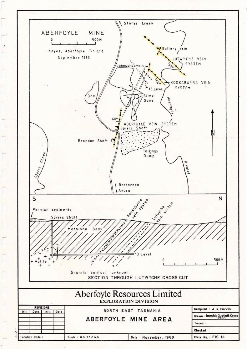
\ Storys (ret,,"
ABERFOYLEoI
MINE500/",
I
V Ej~
•o-
. BaTtery vein
(lUiWHHE VEIN
S'rSTEHJOl'\nson{..:eln,-:-~ So.. "'..,;'~ .
,'I ".~"<,, ...",:..... s.
" ".,.. 0 0 KOOKA9UtlRA" " "' SYS TEM
,~ Oems"
~""""600 ;-
, ABERFOYLE VEIN SyS1EMSpiers Shott /.'________ I
,... 0 " '. 0 • ~ .. : II' .,., '.. - '., I,'. " ',: .....,', .. ' , ' : . : ,,,,,""t- , ,0•• ;...: ..... -
" . - -- loi,llngs........ /Dump
"'eyes, AClerfoyle Tin lto
September 1981)
Brondon Shcft
..•,¢
\
Rossorden
Avo (0
5
PermIan
IseCllments
Spiers Shaft
o• I
N
500 HI
GronlTe contact unkno ... n
SECTION THROUGH LUTWYCHE CROSS CUT
Aberfoyle Resources LimitedEXPLORATION DIVISION
REVISIONSInil. Dati Inil. Dill NORTH EAST TASMANIA Com pi I,d : J.G. Purvis
ABERFOYLE MINE AREADrum :fromMcGushin8Ke)'l!s
Tflu~ :
C~ltkd :
1 locilion Cod,: SCII,: As shown Dill: November, 1988 PIIII No. : FIG 14

SPIER'S Sl-iAFl
R.L1000
" " ., ...
Drawn : a 1fe r Aberfoy Ie
Traced:
Compiled: J.G Purvis
-+ + + -+ + -+ . '+ -t
Aplite ~DEVONIAN
MATHINNA Sub-greywacke DShales SILURIAN
GROUPQuartzites
NORTH EAST TASMANIA
CROSS SECTIONOF THE ABERFOYLE MINE
Aberfoyle Resources LimitedEXPLORATION DIVISION
,/
_______ Rock Boundary
-- Fault•......... Inferred Foul t
.••••••• Quartz Vein
-r.-- Diamond Drill Holl!
REVISIONS
~-------''''F .
··V .. /
I ;:::: ~" ... /. "'~r ?nn,
:2 /..: 0
.' , ..... '/'/-.: ~•• '" / ." I
.' ,'\ :l -+ ~ -+ + -+ + + + J + -I -+ +..... )r :,. : ,. • + + + + + + 12+ + + -+. :. ''\.. -;- :. -+ c::
. -;-.... '/_:.'---:"'-.'--:.,.:.,.,,:....-cj;:~::=.+:::;::~'=';.~=+'=.="=~:\=1fI;==:=:===:==:=:===:====:=:~~~+ : : +~- I ." 13
.... + -+ + -+ .,/+ + + -+ + + + + + U + +~ -+ + + ,. +' + + +
o SCALE 100m Mudstone §§PERMIAN....1 ~I
Init. Date Inil. Date
~ Checked:1t---'----'----L----1I--------------rI------------I-----l----~1 Location Code: Scale: As shown Dale: November, 1988 Plate No,: FI<: 15
II,IIIIIIIIIIIIIIIII,I

Pllte No.: F I 16
Compiled' J. G. Purvis
+
+
+
+
+
+
+
+
+
+
+
+
/
+
+
+
+,•
Dlte : Nove mber, 1988
+
+
+.
+
+
,+- i.::,
I
I/
+
+
Aberfoyle Resources LimitedEXPLORATION DIVISION
NORTH EAST TASMANIA
,,I,- , / -.
,,' / +, /
I
I
~I
.:: ,II
,+ +,I
II
I +I
I.:: I
Scale: As shown
1+I
II,1/
':E~ /--
r
I
"'-,--53
REVISIONSIn it. Date Init. Date
1------+---+--+------11 nterpreted Cross - Section of the Ben Lomond Drawn: from H listen 1979
J---,---+-_-I----1_---iGran Ite a Assoc. Contact Aureole along Traced:
1 J---,---+---I----1----i Storey's Creek to Aberfoyle a Lutwyche ""'C-he-ck-ed-'-~---t51----'--...........-...L.---1r-----------r-----------+----+-------t11 Location Code:
II
IIIIIIIIIIIIIIIII
.1

IIIIIIIII
28.
5.5 Mr. PARIS MASS
LOCATION: The Mt. Paris Tinfield lies to the south of the smalltowns of Branxholm and Derby in N.E. Tasmania, and immediately west ofthe Blue Tier Tinfield. The area is rugged, extending to just over 900melevation at Rattler Hill. It is traversed by numerous forestry tra~ks.
TENURE: The area is currently vacant ground. Some of the known tinoccurrences are covered by small inactive Mineral Leases held byindividuals.
STYLE OF MINERALISATION: Mineralisation is basically of the sameendogranitic styles as found in the adjacent Blue Tier Tinfield. Thenumerous tin occurrences are of three principal types :
1. Quartz-greisen veins.
I 2. Steeply-dipping greisen lodes surrounded by weakly stanniferousargillised granite.
IIIIIIIIIII
3. Flat lying greisen sheets.
All mineralisation is associated with the undulating roof of the graniteintrusion at or close to the contact with overlying Mathinna Bedssediments. The intensity of mineralisation and greisenisation withinthe granite declines rapidly with depth and the bulk of it lies within afew tens of metres of the contact.
The quartz-greisen veins contain coarse cassiterite with sulphides (cp,sp, py, aspy), silver and traces of wolframite and uranium.Occasionally, thin veins occur in the Mathinna Beds directly abovegranite. At RATTLER HILL, a quartz-greisen vein swarm exists in thegranite over an area of 300m x 100m (Young 1981).
The near-vertical quartz-muscovite greisen lodes w~th their surroundingargillised granite halo are the most common style of mineralisationpresent. The argillised (kaolihised) material contains tin gradesbetween 0.025 - 0.1% and was extensively sluiced by the old miners. Thesiliceous lodes are better, if erratically, mineralised but being harderrequired crushing before treatment and thus were largely ignored by theminers. These lodes are generally <2m wide, comprise granular greisenor greisenised granite, and formed when mineralised fluids werechannelled into late-stage fractures at the margins of the graniteintrusion, the fractures being essentially normal to thegranite/sediment contact. There is a noticeable lack of true veiningassociated with this style of mineralisation (Taylor & Rubenach 1981).See Figure 18.
Flat-lying quartz-muscovite greisen sheets, formed by ponding ofmineralised fluids in cupolas beneath the Mathinna Bed contact at theroof of the granite intrusion (as at the Anchor Mine on the Blue Tier),
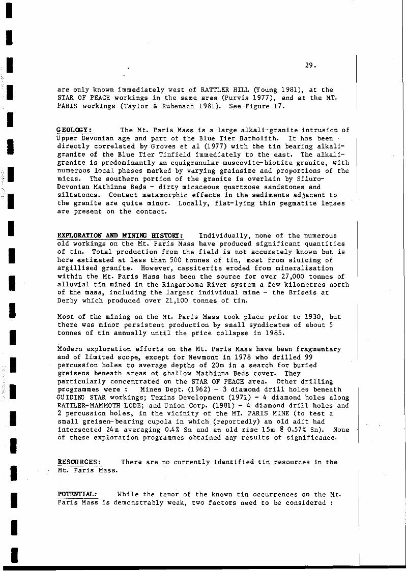
II
,·.1IIIIIIIIIIIIIIIIII
29.
are only known immediately west of RATTLER HILL (Young 1981), at theSTAR OF PEACE workings in the same area (Purvis 1977), and at the MT.PARIS workings (Taylor & Rubenach 1981). See Figure 17.
GEOLOGY: The Mt. Paris Mass is a large alkali-granite intrusion ofUpper Devonian age and part of the Blue Tier Batholith. It has been·directly correlated by Groves et al (1977) with the tin bearing alkaligranite of the Blue Tier Tinfield immediately to the east. The alkaligranite is predominantly an equigranular muscovite-biotite granite, withnumerous local phases marked by varying grainsize and proportions of themicas. The southern portion of the granite is overlain by SiluroDevonian Mathinna Be~s - dirty micaceous quartzose sandstones andsiltstones. Contact metamorphic effects in the sediments adjacent tothe granite are quite minor. Locally, flat-lying thin pegmatite lensesare present on the contact.
EXPLORATION AND HINING HISTORY: Individually, none of the numerousold workings on the Mt. Paris Mass have produced significant quantitiesof tin. Total production from the field is not accurately known but ishere estimated at less than 500 tonnes of tin, most from sluicing ofargillised granite. However, cassiterite eroded from mineralisationwithin the Mt. Paris Mass has been the source for over 27,000 tonnes ofalluvial tin mined in the Ringarooma River system a few kilometres northof the mass, including the largest individual mine - the Briseis atDerby which produced over 21,100 tonnes of tin.
Most of the mining on the Mt. Paris Mass took place prior to 1930, butthere was minor persistent production by small syndicates of about 5tonnes of tin annually until the price collapse in 1985.
Modern exploration efforts on the Mt. Paris Mass have been fragmentaryand of limited scope, except for Newmont in 1978 who drilled 99percussion holes to average depths of 20m in a search for buriedgreisens beneath areas of shallow Mathinna Beds cover. Theyparticularly concentrated on the STAR OF PEACE area. Other drillingprogrammes were: Mines Dept. (1962) - 3 diamond drill holes beneathGUIDING STAR workings; Texins Development (1971) - 4 diamond holes alongRATTLER-MAMMOTH LODE; and Union Corp. (1981) - 4 diamond drill holes and2 percussion holes, in the vicinity of the MT. PARIS MINE (to test asmall greisen- bearing cupola in which (reportedly) an old adit hadintersected 24m averaging 0.4% Sn and an old rise 15m @ 0.57% Sn). Noneof these exploration programmes obtained any results of significance.
RESOURCES: There are no currently identified tin resources in theMt. Paris Mass.
POTENTIAL: While the tenor of the known tin occurrences on the Mt.Paris Mass is demonstrably weak, two factors need to be considered
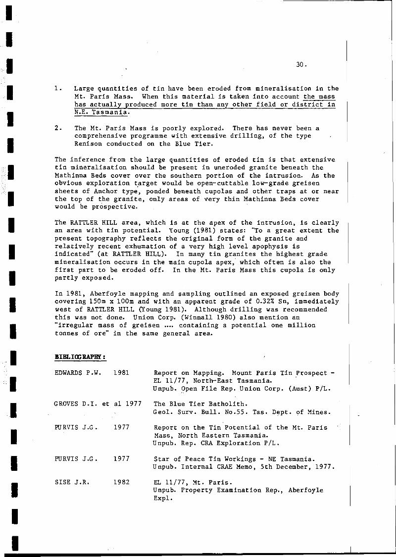
IIIIII
1.
2.
30.
Large quantities of tin have been eroded from mineralisation in theMt. Paris Mass. When this material is taken into account the masshas actually produced more tin than any other field or district inN.E. Tasmania.
The Mt. Paris Mass is poorly explored. There has never been acomprehensive programme with extensive drilling, of the typeRenison conducted on the Blue Tier.
IIIIIII
The inference from the large quantities of eroded tin is that extensivetin mineralisation should be present in uneroded granite beneath theMathinna Beds cover over the southern portion of the intrusion. As theobvious exploration ~arget would be open-cut table low-grade greisensheets of Anchor type, ponded beneath cupolas and other traps at or nearthe top of the granite, only areas of very thin Mathinna Beds coverwould be prospective.
The RATTLER HILL area, which is at the apex of the intrusion, is clearlyan area with tin potential. Young (1981) states: "To a great extent thepresent topography reflects the original form of the granite andrelatively recent exhumation of a very high level apophysis isindicated" (at RATTLER HILL). In many tin granites the highest grademineralisation occurs in the main cupola apex, which often is also thefirst part to be eroded off. In the Mt. Paris Mass this cupola is onlypartly exposed.
In 1981, Aberfoyle mapping and sampling outlined an exposed greisen bodycovering 150m x 100m and with an apparent grade of 0.32% Sn, immediatelywest of RATTLER HILL (Young 1981). Although drilling was recommendedthis was not done. Union Corp. (Winnall 1980) also mention an"irregular mass of greisen ••.• containing a potential one milliontonnes of ore" in the same general area.
,III
BIBLI<J;RAPBI :
EDWARDS P.W. 1981
GROVES D.I. et al 1977
Report on Mapping. Mount Paris Tin ~rospect EL 11/77, North-East Tasmania.Unpub. 9pen File Rep. Union Corp. (Aust) PILe
The Blue Tier Batholith.Geol. Surv. Bull. No.55. Tas. Dept. of Mines.
IIIII
PURVIS J.G.
PURVIS J.G.
SISE J.R.
1977
1977
1982
Report on the Tin Potential of the Mt. ParisMass, North Eastern Tasmania.Unpub. Rep. CRA Exploration PILe
Star of Peace Tin Workings - NE Tasmania.Unpub. Internal CRAE Memo, 5th December, 1977.
EL 11/77, Mt. Paris.Unpub. Property Examination Rep., AberfoyleExpl.

I::1::::1
IIIIIIIIIIIIIIIIII
TAYLOR R.G. & 1981RUBENACH M.J.
WINNALL N. J • 1980
WINNALL N. J • 1981
WINNALL N. J • 1982
YOON; C.H. 1981
31.
Some Observations Upon the Mt. Paris TinPros pee to Unpub. Rep. to Union Corp. (Aus t)P/L.
Preliminary Report - EL 11/77.Unpub. Open File Rep. Union Corp. (Aust) P/L.
Six Monthly Report - EL 11/77.Unpub. Open File Rep. Union Corp. (Aust) P/L.
Final Report - EL 11/77.Unpub. Open File Rep. Union Corp. (Aust) P /L.
Rattler Hill ML 77M/77.Unpub. Property Examination Rep. Aberfoyle Expl.

Tertiary - Quaternary sediments a basalts
Mad.. oroined biotite gran'lte (muscovite), greisenised granite 8 greisenIlOftah Sheets J Mt. Paris Mass, Mt. Wilham Mass, MI. cameron SheeTs IPorphyritic biotite· adamellite
N) . i
~. ( ;,I / Ii
I .. f\
V////lI· ]: ".: '. ';: :.
I· + + 1I,- - -I,,, .': .1 Sm I
Sm
Biotite hornblende granodiorite
Mathinna Beds
veins.
& So Lodes
+
+
+
+
Aberfoyle Resources LimitedEXPLORATION DIVISION
NORTH EAST TASMANIA
GEOLOGYMT. PARIS MASS
REVISIONSInil. Dal. Inil. 00111
1 lO~'l1ion Coil. : Sui. : As shown OU.: December. 19BB
Compil.d : J. G. Purvis
Urn"," : aft. Groves 19n
Tlnlll: RJE
Chuhl! :
Plall Mo.: FIG 17
- - - - - - - - - - - - - - - - - - .-. - -
Porphyritic granitefine grained t cavities,some section. albitised,some grel8enlsecf
............01......
ITIIIII~o'
gl"III~~i~ z;:: '"
CO
;1 I I N~ II I II
enn..~ , . >:x:. 0 ~CIt» \JCIt G> 3: ~if ::tJ -t ~;l» ~:> ~~:1J ty10z ~ » z ~"<-n 0 ~
rn» ~:u ~~::tJ "'""i (J) -; 0 ""r'1»() :I::;l:l ~r fTI ~ ~
-z::1 ~ jen~"'""i Z -; 00
~I"'""irn -; Z ~.. _::tJ <: l> tj~
0"'0 < CJ)-nz z::O 0 3: <",o rn l> - , ..~ (J)"'""i::O z ~en3 "'""i» " i: 0 ........ Mathina Bed Sediments:i ~ "'""i - Z l (Stoped blocks)~... r 0 z a~' Siliceous' mudstones etc.iD (J)fT1 Z Ci) Andalusite grade contact(J) (J) ,.... metamorphIsm.(J) 0 f"""+
""Tl ~
0..
MT TERRORCUPOLA
?
Greil"n sheet (Quartz -muscovite:!: Sn 02)
Ar ill ic A !tera t ioncontains tin 300-500ppm)(Possibly overpointingearlyalbitisation,· also postdatedgreisen formation)
+
+
s
+
/+ +",.; ::.. '>.;:.":.::..+':-:-..'.::.:.::.",
Fresh granite( Equ)granular,med.grained)
~ ('1 ::;4 co ~ . • •Oi .... .. 0;; .. .. :E :In .. ~... ... ~
z .. .. .-~
... .. ..."rlG) After Taylor a Rubenach, 19BI
(J)I I I
IIIIIIIIIIIIII-IIIIIII
32.
5 .6 ALIDVIAL PROSPECTS
LOCATION: Alluvial tin deposits occur in the drainage basin of theRingarooma River in the NE corner of Tasmania, between the town ofBranxholm and the sea at Ringarooma Bay. The area is low-lying andincludes farmland and marshes.
TENURE: The on-shore areas of best large-scale dredging potential, inthe lower reaches of the Ringarooma River system, are held under aseries of Retention Licences by Triako Mines NL (RL 872 at GreatNorthern Plain), and Hellyer Mining & Exploration - a division of Santos(RL's 8715 and 8723 at Fosters Marshes). Adjacent areas . with potentialin this northern area are held under EL's (see Figure 2).
The off-shore area with potential, the eastern half of Ringarooma Bay,is held by Mineral Holdings Pty. Ltd. under EL 92/87. The upper half ofthe Ringarooma River system which historically was the best producingarea, is free of title except for Retention Licence 871 held by Triakoover the Pioneer workings. This picture is clouded by numerous smallML's situated over old workings.
MINING HISTORY: Approximately 44,500 tonnes of tin have beenproduced from the Ringarooma system since mining began in the 18705.Working has been by sluicing and dredging. The bulk ofproduction occurred prior to 1930 and there has been a steady declinesince. The last major mines (Pioneer and Endurance) closed in 1982-83and production has since ceased completely.
The fields major producer was the Briseis Mine at Derby which produced21,140t Sn, followed by the Pioneer Mine at Pioneer (9750t Sn),Endurance Mine at South Mt. Cameron (3,500t Sn), the Dorset dredge(2,300t Sn), and the Arba Mine at Branxholm (2,300t Sn). Although therewere countless smaller producers none of them produced )1000t Sn.
GEOLOGY: The Ringarooma River system drains northwards from the tin-bearing Devonian alkali-granites of the Mt. Paris Mass and Blue TierTinfield. During Tertiary times, subsidence formed a land-lockedlacustrine basin in the upper part of the Ringarooma River system southof the granitic Mt. Cameron Massif. At the same time, erosion exposedthe mineralised roof zones of the alkali-granites immediately south ofthe basin.
Tributary rivers entering the basin along its south-eastern marginformed fluvial cones of the cassiterite-bearing granite-deriveddetritus, at the break in slope between their steeper upper courses andthe flatter gradient in the basin. These rich tin deposits were buriedbeneath later detritus and, in places, sheets of Tertiary basalt. Thedeep leads were later exhumed by the present river and each lead formedthe basis of the more-important mines (see Figure 19).

IIIIIIIIIIIIIII
33.
To the north of Mt. Cameron several major basins formed during the earlyTertiary, the most important being in the lower reaches of theRingarooma River (the Great Northern Plains Basin) and in the lowerreaches of the Boobyalla River (the Boobyalla Basin). These basinsfilled with fluvial, estuarine and shallow marine sediments, mainlyderived from tin-bearing granitic detritus as well as some gold-bearingMathinna Beds detritus, brought down by the Ringarooma and Boobyallarivers.
Subsidence in the basins ceased in the Late Tertiary and was followed byextrusion of basalt sheets. Uplift in the Quaternary led to erosion ofthe basalt and reworking of some of the Tertiary alluvial tin intoyounger deposits along the present drainage channels.
The northern basin deposits are more extensive but much lower grade,than those in the upper basin where the vast bulk of production has beento date.
RECENT EXPLORATION HISTORY: Although there has been almost noexploration activity on the N.E. alluvials since the tin price collapsein 1985, the previous 20 years had seen extensive evaluation anddrilling. This included programmes by many major companies who mainlytargetted the Great Northern Plain area for its large-scale dredgingpotential. Programmes here were conducted by Dorset Tin, RTAE, Utah,BHP, Mines Dept., Wanex, Preussaq and Santos. The Santos programme(1981-83) was particularly comprehensive and provides the bestassessment of this area.
In the upper basin, much work was carried out by Amdex (a division ofTriako Mines NL and owners of the now-closed Pioneer and Endurancemines), especially in the period 1978-1985. Amdex were joined in JV byAnglo American from 1981-85.
The offshore tin potential in Ringarooma Bay was tested by Ocean MiningAG in 1965-66, who drilled 138 shallow holes into the sea floor afterbathymetric and seismic surveys had indicated the presence of a drownedchannel of the Ringarooma River. Although the offshore area has beenheld under EL -s by several parties since (including CRAE 1980-83), nofurther drilling has been carried out.
I RESaJRCES: See Table 3.
IIIII
ACCESSORY MINERALS There were significant amounts of ilmenite, zircon,monazite, gold, and to a lesser extent rutile, in some of the workeddeposits although these were largely ignored by the tin miners. Thereis almost no data on which to judge the average grade of such mineralsin the deposits.
The Dorset dredge reportedly produced 6935 oz of gold (Bowen 1980), andthe Pioneer and Endurance mines together produced about 30 oz of goldannually. There is more gold in the younger river channel depositsthan in the Tertiary deep leads.
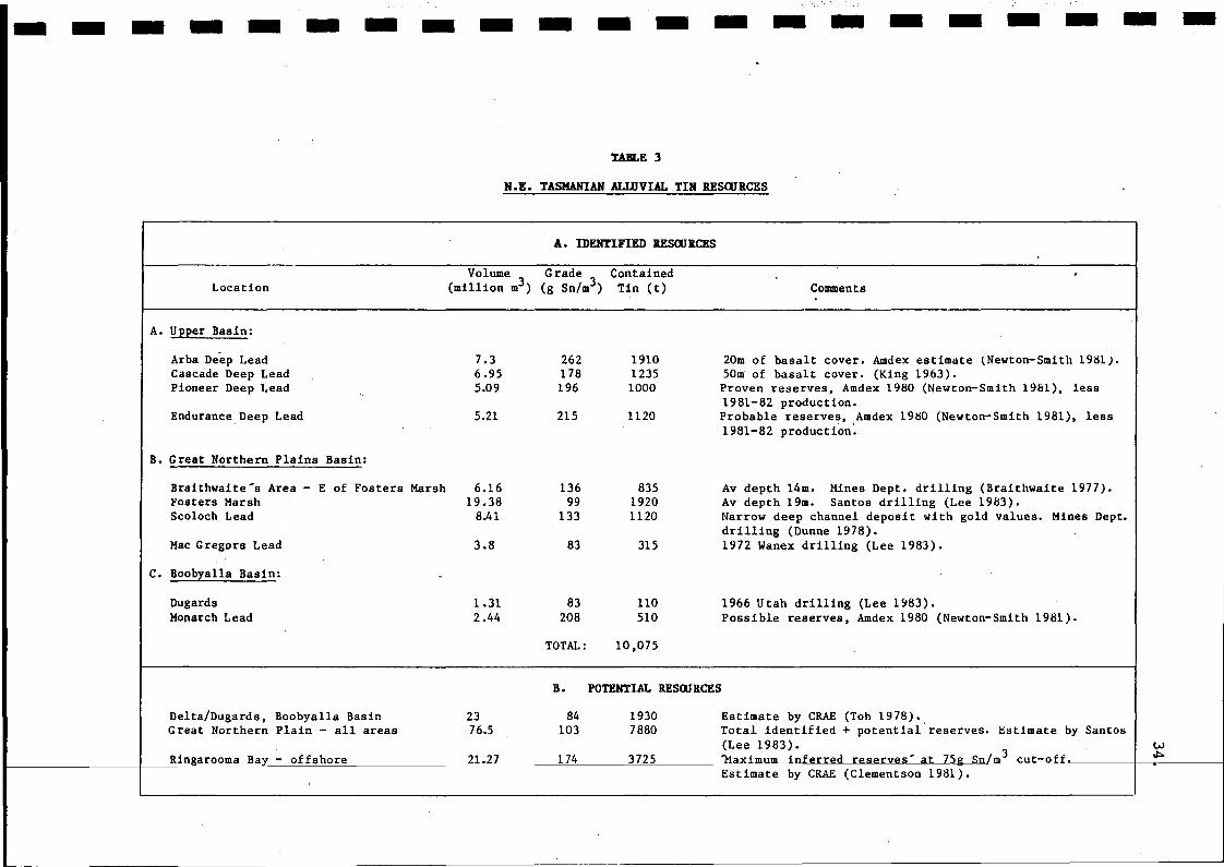
- - - - - - - - - - - - - - - - - - - - -
Location
TABLE 3
H.E. TASHAHIAH ALWVIAL TIH RESaJRCES
A. IDENTIFIED RESaJRCES
Volume Grade Contained(million m3) (g Sn/m3) Tin (t) Comments
A. Upper Basin:
Arba De-ep LeadCascade Deep LeadPioneer Deep Lead
Endurance,Deep Lead
B. Great Northern Plains Basin:
Braithwaite's Area - E of Fosters MarshFosters MarshScoloch Lead
Mac Gregors Lead
C. Boobyalla Basin:
DugardsHoparch Lead
7.36.955.09
5.21
6.1619.38
8.41
3.8
1.312.44
262178196
215
13699
133
83
83208
191012351000
1120
83519201120
315
110510
20m of basalt cover. Amdex estimate (Newton-Smith 1981).50m of basalt cover. (King 1963).Proven reserves, Amdex 1980 (Newton-Smith 1961), less1981-82 production.Probable reserves, Amdex 1980 (Newton-Smith 1981), less1981-82 production~
Av depth 14m. Mines Dept. drilling (Braithwaite 1977).Av depth 19m. Santos drilling (Lee 1983).Narrow deep channel deposit with gold values. Mines Dept.drilling (Dunne 1978).1972 Wanex drilling (Lee 1983).
1966 Utah drilling (Lee 1983).Possible reserves, Amdex 1980 (Newton-Smith 1981).
TOTAL: 10,075
B. POTENTIAL RESaJRCES
Delta/Dugards, Boobyalla BasinGreat Northern Plain - all areas
Ringarooma Bay - offshore
2376.5
21.27
84103
174
19307880
3725
Estimate by CRAE (Toh 1978).Total identified + potential'reserves. Estimate by Santos(Lee 1983). w'Maximum inferred reserve,,'.<It 7'ig~-",--m3----,c,-"u,-,----t'-~O~f'~f ---I_~~ -----j
Estimate by CRAE(Clementson 1981).
IIIIIIIIIIIIIIIIIIIII
35.
There is abundant ilmenite and monazite in some of the upper basin deepleads. Morrison (1981) found monazite comprises 6% of the HM content atPionee~ with ilmenite 28% and zircon 3.4%. He noted monazite was most ab ndantin the Endurance-Pioneer area, and each produced some 30-40t of monaziteduring World War II. There are no mentions of monazite in the GreatNorthern Plain deposits although ilmenite, gold, zircon and rutile arepresent.
POTENTIAL: The volume of data on the N.E. Tasmanian tin alluvials isenormous and a comprehensive evaluation of the potential is beyond thescope of this report. The broad outline of the situation is readilyapparent.
On-shore there are low-grade potentially-dredgeable tin deposits in theGreat Northern Plains and Boobyalla basins. The indic~tions are thatthese deposit~ are individually less than 25 million m , a~gregate up to100 million m , and have an average grade around 100g Sn/m. Thepotential here thus totals around 10,000 tonnes of contained tin. Thedeposits contain minor, but economically important, amounts of gold,ilmenite, zircon and rutile.
Santos (Lee 1983), in their excellent summary report on the GreatNorthern Plains area, estima~ed the total potential resource at 76.5million m3 grading 103g Sn/m. This resource occurs in several separateblocks on a single blanket-like Quaternary gravel layer containingirregularly-distributed cassiterite concentrations. It extends northwest along the eastern side of the Ringarooma River from Mac Gregorsworkings to Bowlers Lagoon - a distance of 6 km. Santos concluded "theprospect represents an excellent dredging proposition if adequatereserves can be located" (Lee 1983). The tin price at that time was$A13 ,000 /tonne.
However, there are problems relating to land use and tenure in thesenorthern Tertiary basins. Much of the Great Northern Plain is listed inthe Register of the National Estate and a substantial portion of thepotential dredging zone is privately owned land with mineral rightsvested in the owner. It was as much for these reasons, as for thefalling tin price, that Santos stopped exploration in 1983 and acceptedthe Government's offer of a Retention Licence over the deposits.
In the upper basin south of Mt. Cameron the deposits are smaller buthigher grade. Problems here related to depth of overburden (whichstopped the old mines), and the fact that some of the resources lieunder private farmland. Over 5000 tonnes of contained tin have beenidentified by drilling in the known extensions of the Arba, Cascade,Pioneer and Endurance deep leads. Monazite would be an economicallyimportant accessory, along with ilmenite, zircon and gold.

II
IIIIII
36.
For the combination of both potential resource size and absence ofenvironmental/land use problems, the drowned channel deposit on the seafloor in the eastern part of Ringarooma Bay appears to be the mostattractive alluvial tin deposit in NE Tasmania.
The indicated grade at IS0-17Sg Sn/m3 is significantly higher than inthe dredgeab1e on-shore areas. The indicated volume figure (21-23million m3) is highly unreliable and probably much too low. It islimited by the reconnaissance nature of the drilling (only 15 holesintersected the deposit over an area of 11.5 km2), the fact that thedrill holes only penetrated S-6m into the seabed, and the fact thatdrilling was limited to a maximum water depth of 33m with the depositbeing left open to the north. The value of the likely accessoryminerals (ilmenite, .zircon, rutile and gold) has also not been assessed.
The Ringarooma Bay deposit has not been tested since the initialdrilling in 1965-66. Of all the NE alluvial tin deposits it appears tomost warrant further investigation.
BIBLI<x;RAPBY :
CLEMENTSON LM. 1981
BRAITHWAITE J.B. 1977
IIIIII
ANON
BOWEN E.A.
BROWN A.V.
1967
1980
1978
Proposed T.O.E.C. III Programme, RingaroomaBay. Tasmania.Unpub. Open File Rep. Ocean Mining AG.
Ringarooma Tin : Assessment of ExplorationPotential.Unpub. Open File Rep. Amax.
Great Northern Plain : A possible dredgingarea.Tas. Dept. of Mines Tech. Reps No. 20. pp62-67.
Tertiary Leads and Basin in the Winna1eah - Mt.Cameron Area. Appendix 1 in Geol. Surv. Bull61, pp 170-173.
Notes on Ringarooma Bay Offshore TinPotential. Internal CRAE memo, in Dickson1983.
III
CLEMENTSON LM. Undated
COLLINS P.L.F. 1982JENNIN:; S D.J .
Notes on the Alluvial Tin Potential of theRingarooma Bay Area and CRAE EL 48/80, NETasmania.Unpub. Open File CRAE memo.
A Review of Tasmanias Tin Resources and theirMineralogy. Unpub. Rep. No. 1982/23, Tas.Dept. of Mines.
III
DICKSON T.W. 1983 EL48/80 - Ringarooma Bay, Tasmania.Relinquishment Report 17th January, 1983.Unpub. Open File Rep. CRAE.

OONNE W.T. 1978
TOH E. 1978
JENNIN; S D.J. 1975
WESTHOFF J.B. 1981
Great Northern Plain. Geological SummaryReport.Unpub. Open File Rep. Santos Ltd.
Ringarooma Joint Venture, Northern Tasmania.Assessment of the Project Area andRecommendations for Stage 1 Exploration andDrilling.Unpub. Open File Rep. Preussaq Aust. Pty. Ltd.
Great Northern Plains Alluvial Tin Prospect.Introductory Report. Unpub. Open File Rep.
Alluvial Tin Deposits of Tasmania. In Econ.GeoL of Aust. & PNG VoL 1. Aus IMM Monograph5, pp 1053-54.
Report on the Tin Resources of Tftsmania.Unpub. Open File Rep. Utah Development Co.
South Mount Cameron EL2/77. Report for the SixMonths Ending 7th March, 1981.Unpub. Open File Rep. Amdex Mining Ltd.
A Preliminary Review of the Alluvial TinPotential of the Ringarooma Valley.Unpub. Open File Rep. Aust. Anglo American Ltd.
37.
EL19177. Great Northern Plain. QuarterlyExploration Progress Report for Period Ending11th July, 1982.Unpub. Open File Rep. Hellyer Mining & Expl. p/L.
Notes on the Great Northern Plains Alluvial TinProspect, Tasmania.Appendix to Hellyer Min. & Expl. Monthly Rep.Jan., 1981. EL19/77.
Prospects for Alluvial Tin Dredging In andAround Eastern Marshes, Ringarooma District,N.E. Tasmania.Unpub. CRAE Rep.(Not sighted - quoted inClementson, undated).
Review of Prospects, Ringarooma Permits, N.E.Tasmania.Unpub. Open File Rep. RTAE.
Ringarooma Joint Venture, ELZ/77. SurrenderReport For the Dept. of Mines, Tasmania, to 7thMarch, 1985.Unpub. Open File Rep. Aust. Anglo American Ltd.
1982
1963
1981
1983
MORRISON K.
KIN; D.
LEE S.
NEWTON-SMITH J. 1981
RATTIGAN J.H. 1958
WELLS K. 1978
SHAW R.W.L. 1985
LEE S.
IIIIIIIIIIIIIII
II
·1III

,.
•~
" ...4, RJE
C...,il,4, JG P
Chc.,4, JGP
'I.,. ""i' FIG III
r A .... " ,.
Jurenlc dolorllo
Tributary deep Ilod
Worhd olluvlCII lin ""POOIIl
QUClIrncry a Ten"'')'..di","nTl "~h locol baso" """or
D.vonkln G,anl'.
Silurlon ~cl"lnno B,d,..dl...... '".
x
LEADS
I22J8".....,
Dlumb." 1'811D." ,
,, ,K ,,
",, , LOCALITY MAP
, ,, , ,,< ,
, , ,
, <
';.'
NORTH EAST TASMANIA
MAIN ALLUVIAL TIN OEPOSITSNO RTH - EASTERN TASM A NIA
l Modilled Itom JonninQ', 197' I
Ao .1>0....
,O~ ,,!5 I(mo; ;
OFTHE
Aberfoyle Resources LimitedEXPLORATION DIVISION
$..1. ,
D.,.RIVI$IDNS1.1.. D.,. ,.i•.
Io"H.. c.4. ,
Allu."'1 lin "epodIn <lro"""" c!I<lr"rnol
_/ of Rlnooroomc/~; RI••t.
",
-"/ l21-23~lon ",'lDl~O'17!l, ~Sn/m')
,.
..;.
. ....::.::": . ' .
.~0tf:;
' .
N
L
L
L
[ ..•. /> ,.~y / ), .
L


![IJ 1 - mrt.tas.gov.au · i"-~ i~-~ i~! oj i] ij ij iii.. ij iii 1 1-'i i . i 489001 tin - tungsten - base metal mineralization associated with the ben lomond granite batholith 111](https://img.pdfslide.net/doc/110x75/5b55a34f7f8b9ac5358bc907/ij-1-mrttasgovau-i-i-i-oj-i-ij-ij-iii-ij-iii-1-1-i-i-i.jpg)