Embed Size (px)
Citation preview

Technical Workshops |
Esri International User ConferenceSan Diego, California
NetCDF and HDF Data in ArcGISNawajish Noman
Kevin Butler
July 25, 2012

• NetCDF and HDF in ArcGIS- Demo 1
• Visualization and Analysis- Demo 2
• Customization using Python- Demo 3
• Future Directions
Outline

• Direct support - NetCDF and HDF• THREDDS/OPeNDAP – a framework for scientific data
networking, integrated use by our customers• Examples using Esri technology
- National Climate Data Center- National Weather Service- National Center for
Atmospheric Research- U. S. Navy (NAVO)- Air Force Weather- Australian Navy- Australian Bur.of Met.- UK Met Office
Scientific Data and Esri

• ArcGIS reads/writes netCDF since version 9.2
• An array based data structure for storing multidimensional data.
• N-dimensional coordinates systems• X, Y, Z, time, and other dimensions
• Variables – support for multiple variables• Temperature, humidity, pressure, salinity, etc
• Geometry – implicit or explicit• Regular grid (implicit)• Irregular grid• Points
X
Z
T
Y
NetCDF Support in ArcGIS

Regular Grid
Irregular Grid
Gridded Data

• NetCDF data is accessed as• Raster• Feature• Table
• Direct read• Exports GIS data to netCDF
Reading netCDF data in ArcGIS

Climate and Forecast (CF) Conventionhttp://cf-pcmdi.llnl.gov/
Initially developed for• Climate and forecast data• Atmosphere, surface and ocean model-generated data• Also for observational datasets
• The CF conventions generalize and extend the COARDS (Cooperative Ocean/Atmosphere Research Data Service) convention.
• CF is now the most widely used conventions for geospatial netCDFdata. It has the best coordinate system handling.
CF Convention

• Geographic Coordinate Systems (GCS)• X dimension units: degrees_east• Y dimension units: degrees_north
• Projected Coordinate Systems (PCS)• X dimension standard_name: projection_x_coordinate• Y dimension standard_name: projection_y_coordinate• Variable has a grid_mapping attribute. • CF 1.6 conventions currently supports thirteen predefined coordinate
systems (Appendix F: Grid Mappings)
• Undefined • If not GCS or PCS
• ArcGIS writes (and recognizes) PE String as a variable attribute.
NetCDF and Coordinate Systems

Toolbox: Multidimension Tools• Make NetCDF Raster Layer• Make NetCDF Feature Layer• Make NetCDF Table View
• Raster to NetCDF• Feature to NetCDF• Table to NetCDF
• Select by Dimension
NetCDF Tools

RasterRaster
FeatureFeature
TableTable
NetCDF Layer/Table Properties

Time = 1
Changing Time Slice

Reading HDF in ArcGIS

• Raster Format (e.g. img, tif, etc.)- driver level support / storage format and layout / read/write of pixels and metadata
• Raster Type (e.g. GeoEye-1)- implies Raster Format support and are format and sensor specific- intelligent use of metadata and other sensor specific parameters- defines georeferencing and well known processing chains
• Raster Product (e.g. Panchromatic, Multispectral, Pansharpened )- templates which make it easy to work with well defined end user products- multiple per sensor- e.g. Panchromatic, Multispectral, Pansharpened
• Raster Product Definition (e.g. Natural Color, False Color)- defines “how you want your Mosaic Dataset to look” regardless of multiple source sensors and band
combinations- uses metadata such as wavelength information to map bands
Raster Concepts

Raster Concept ArcGIS 10.1 SupportRaster Format HDF4
• read: open a HDF subdataset as a Raster Dataset • write: APIs available but not exposed in UI
HDF5• read: open a HDF subdataset as a Raster Dataset• write: not supported at this time
Raster Type HDF4, HDF5• direct ingest of one or many HDF subdatasets into a
Mosaic Dataset using the Raster Dataset Raster Type or the Table Raster Type
* Esri interested in discussing other Raster TypesRaster Product * Esri interested in discussing other Raster Products
Raster Product Definition * Esri interested in discussing other Raster Product Definitions
HDF Raster Support

• 10.1 Raster Format and Raster Type support implies…- ArcGIS Desktop
- direct use as a Raster Dataset or Mosaic Dataset- use via conversion (i.e. convert to another format)- feature rich use in the applications
- Visualization and Mapping
- Geoprocessing
- ArcGIS Server- publishing as dynamic image services- caching and publishing as tile services (i.e. basemaps)- OGC (WCS, WMS, WMTS)
HDF Raster Support
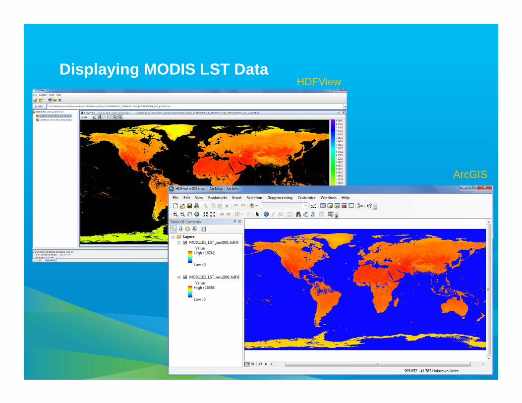
HDFView
ArcGIS
Displaying MODIS LST Data
Demo: Reading netCDF and HDF data

Behaves the same as any layer or table • Display
• Same display tools for raster and feature layers will work on netCDFraster and netCDF feature layers.
• Graphing• Driven by the table just like any other chart.
• Animation• Multidimensional data can be animated through a dimension (e.g. time,
pressure, elevation)
• Analysis Tools• A netCDF layer or table will work just like any other raster layer, feature
layer, or table. (e.g. create buffers around netCDF points, reprojectrasters, query tables, etc.)
Using netCDF Data
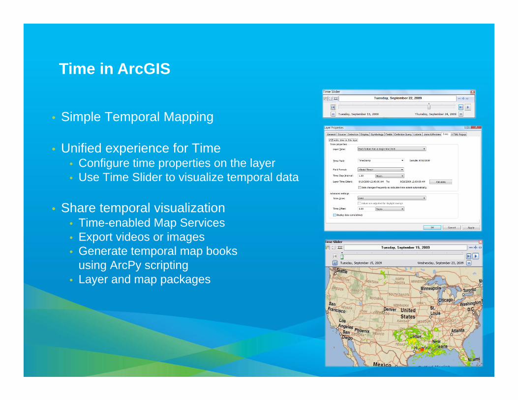
• Simple Temporal Mapping
• Unified experience for Time• Configure time properties on the layer• Use Time Slider to visualize temporal data
• Share temporal visualization• Time-enabled Map Services• Export videos or images• Generate temporal map books
using ArcPy scripting• Layer and map packages
Time in ArcGIS

1979
Animation Examples

• Several hundreds analytical tools available for raster, features, and table
• Temporal Modeling• Looping and iteration in ModelBuilder and Python
Spatial and Temporal Analysis

• Calculates specified statistics for all time steps• Outputs a raster catalog• Optionally outputs a netCDF file
Generate Rainfall Statistics

• Calculates statistics for all time steps• Outputs a table• Optionally creates a graph
Generate Rainfall Statistics Table

Demo: Animation and Analysis

• Geoprocessing Resource Centerhttp://resources.arcgis.com/geoprocessing/
• Marine Geospatial Ecology Tools (MGET)
• Developed at Duke Univ.• Over 180 tools for import
management, and analysis of marine data
• Australian Navy tools(not publicly available)
Community Developed Tools

• Python is used to build custom tools for specific tasks or datasets
Script Tools

Reading Features from a netCDF File

• Download NetCDF File (OPeNDAP, WCS)• Clip
• Extract By Variable• Extract By Dimension• Append By Dimension
• Variable Statistics• Temporal Statistics
New NetCDF Tools (under development)

Download NetCDF File (WCS/OPeNDAP)

• netcdf4-python • This module can read and write files in both the new netCDF 4 and the
old netCDF 3 format, and can create files that are readable by HDF5 clients.
• Pydap• Pydap is a pure Python library implementing the Data Access Protocol,
also known as DODS or OPeNDAP. OWSLib
• OWSLib (OGC Web Service utility library)• Package for working with OGC map, feature, and coverage services.
OWSLib provides a common API for accessing service metadata and wrappers for GetCapabilities, GetMap, and GetFeature requests.
Dependencies on 3rd Party Utilities

Demo: Workflow and Customization

HDF and Swath

• Esri hosted a workshop in February 2012• To understand the future need for scientific data support in ArcGIS• Ongoing efforts - require close collaboration with all of you
• Some of the future initiatives are:• Continue to support netCDF classic and netCDF4• Provide better support for HDF5• Provide tool to consume data served using THREDDS/OPeNDAP• Continue to support the evolving CF convention• Support a strong developer experience for netCDF and HDF using Python
• What else?
Scientific Data Workshop and Future Initiatives…

• Embrace the Common Data Model (netCDF, HDF etc.)• Use Data and metadata standards (OGC, CF etc)
• Provide “mechanism” so that we can access scientific data using a single set of APIs….
• and can expect data to be CF complainant
• Make your data “spatial” (by specifying geographic or a projected coordinate system)
• Clearly define workflow and requirements• Create sample tools where possible
Things to Consider…

Steps to evaluate UC sessions
• My UC Homepage > “Evaluate Sessions”
• Choose session from plannerOR
• Search for session
www.esri.com/ucsessionsurveys

• Thank you for attending
• Have fun at UC2012
• Open for Questions
• Please fill out the evaluation:
www.esri.com/ucsessionsurveys
First Offering ID: 756