Embed Size (px)
Citation preview

Laser-Scan and GML
• UK company - member of the Yeoman Group– in digital mapping since 1974
• Long-time members of OpenGIS consortium– Provided primary author of GML-1 spec (AC)– Took part in WMT1 and 2, OWS1.1, 1.2
• Implemented SOTF to prototype next generation GML with Change-Only Update and topology
• Primary supplier of spatial technology to OSGB who are using GML as basis of new MasterMap
• Contributing topology expertise to GML-3

GML 2.0 in actionOS MasterMap
OrdnanceSurveyCrownCopyright

Example of data from GML in
LAMPS2Data courtesy ofTopografische Dienst

GML Relay 2002 Data (Gothic LAMPS2)

LSL Approach to Relay
• Now using 3rd party tools– to let us focus on our key technologies
• Emphasis of this demo is on– interoperability– topological structure
• Looking forward to GML-3

GML Relay 2002 Data (MapInfo/Oracle/Radius)

Topology
• Mathematical concept of spatial structure: “Characteristics of geometry which do not change when the coordinate space is deformed”
• Express explicit geometric relationships– connects to, touches, adjacent to, within
• Topology Primitives– Node, Edge, Face, Solid
• Should be present in most GIS data– Shared edges between land polygons– connected networks of roads

Shared Edges, Shared Nodes

Radius Topology
• Enterprises and agencies want to hold business and spatial data in one database
• Radius Topology is the server-side topology manager for Oracle9i
• Enhances spatial data quality and query performance.
• Calculates and stores the topology in tables, using standard ISO 19107 model.
• Based on proven topology engine from Laser-Scan Gothic object database and toolkit

Today’s LSL Relay
RadiusTables
RadiusTriggers
RadiusTopology
Engine
Businessdata
Spatialdata
Oracle9i
SQL
OC
I
IntergraphGeoMedia
SnowflakeGo Loader
GMLGML MapInfo

Go Loader

Radius Topology Configuration Manager

Radius TopologyClasses and Priorities

Most GIS data is Spaghetti
gaps slivers
under-shoots
overshoots
… data faults affect query quality

Snapping and Topology
...or...

Rules: Node Formation
Edge Split EdgeShare Node Node Split Edge

Priorities: Gold Standard Data
- High priority feature
- Low priority feature
Before
After

Face Topology - Containment
Need to find all features on the lake

Face Encoding
<gml:Face id="f1">
<gml:posEdge xlink:href="#e1"/>
<gml:posEdge xlink:href="#e2"/>
<gml:negEdge xlink:href="#e2"/>
<gml:posEdge xlink:href="#e3"/>
<gml:negEdge xlink:href="#e3"/>
<gml:isolated xlink:href="#n3"/>
</gml:Face>
Face records all adjacency and containment through encoding for boundary and isolated

GML 2.0 and 3.0 Geometry
• GML 2.0 provides for:– Simple geometry types
• Point/MultiPoint• LineString/MultiLineString• Polygon/MultiPolygon
– Boundary Types• LinearRing
– Simple linear interpolation
– Coordinates up to 3D
• GML 3.0 geometry– from ISO 19107– superset of GML 2.0– Geometric primitives up
to 3D volumetric solids– composites (line/arc)– splines, conics, tins– curves and surfaces.
• Topology model
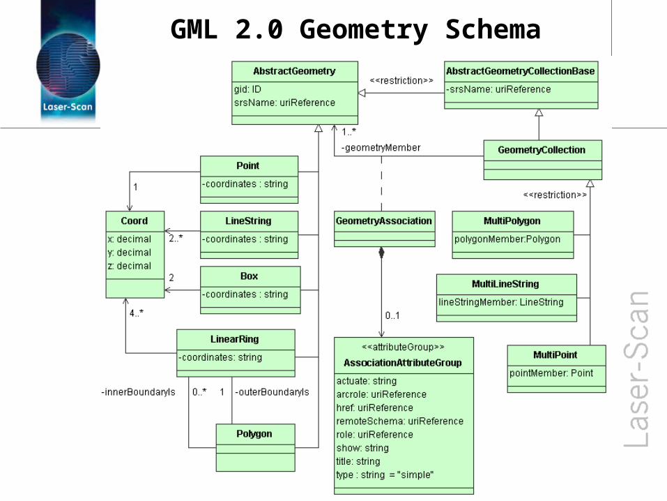
GML 2.0 Geometry Schema

AS Topic 1/ISO 19107 Geometry
GML 2.0
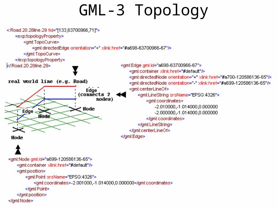
GML-3 Topology
Edge
Edge

Spatial Query Performance“Find all districts which touch or are covered by the county of Cambridgeshire (UK)”

Spatial Query Comparison
0.048 0.22
91
0102030405060708090
100
Oracle Spatial Oracle SpatialOptimised
Radius Topologyinside
Oracle Spatial
Features found per second
At Least 400 times faster !

Error in Topology

Edges & Nodes

Edit of Edge modifies both polygonsEdges & Nodes created dynamically

Export to GML via GeoMedia

Resultant XML (in MSIE)

Resultant XSD Schema

Round trip the exported GML(with faulty projection!)