Embed Size (px)
Citation preview

NEW BUSINESS CALENDAR
CITY PLANNING COMMISSION AGENDA
ITEM NO(S): 4.A – 4.G
STAFF: RYAN TEFERTILLER
FILE NO(S):
A. - CPC CP 04-00127-A2MJ11 – QUASI-JUDICIAL B. - CPC ZC 11-00015 – QUASI-JUDICIAL C. - CPC ZC 11-00016 – QUASI-JUDICIAL D. - CPC ZC 11-00017 – QUASI-JUDICIAL
E. - CPC V 11-00018 – LEGISLATIVE F. - CPC DP 11-00019 – QUASI-JUDICIAL G. - CPC NV 11-00232 - QUASI-JUDICIAL
PROJECT: GOLD HILL MESA FILING NO. 3 APPLICANT: N.E.S. INC. OWNER: GOLD HILL MESA PARTNERS, LLC / GOLDEN CYCLE INVESTMENTS, LLC /
VILLA DE MESA HOMEOWNERS ASSOCIATION
CPC Agenda July 21, 2011 Page 33

PROJECT SUMMARY:
1. Project Description: Approval of this project accomplishes a number of goals within the Gold Hill Mesa development area: the construction of 20 new single-family homes; the vacation and realignment of Villa De Mesa Dr.; modifying the concept plan’s land use pattern and road network; and modifying the boundaries of the three prominent zone districts. Specifically, Planning Commission must act on eight land use applications: a major amendment to the Gold Hill Mesa concept plan; three zone changes; a vacation of right-of-way; the Gold Hill Mesa Filing No. 3 development plan; and four non-use variance requests. A ninth application, the Gold Hill Mesa Filing No. 3 subdivision plat, is being processed administratively.
2. Applicant’s Project Statements: (FIGURE 1)
3. Planning and Development Team’s Recommendation: Approval of the applications, subject to conditions.
BACKGROUND:
1. Site Address: Numerous – the site includes many properties generally located south of US-24, east of S. 21st St., north of Lower Gold Camp Road, and west of the developed and undeveloped properties access from Gold Hill Terrace, Cherokee St., and Garner St.
2. Existing Zoning/Land Use: TND (Traditional Neighborhood Development), PUD (Planned Unit Development), and PBC (Planned Business Center) / single-family, multi-family, commercial and vacant (FIGURE 2)
3. Surrounding Zoning/Land Use: North: M-1 (Light Industrial) and R2 (Two-Family Residential) / US-24 right-of-way, industrial and residential land uses South: R5 (Multi-Family Residential), PUD (Planned Unit Development), PK (Public Parks), and R-1-6000 (Single-Family Residential) / residential land uses and Gold Camp Park East: R (Estate, Single-Family Residential) and PUD (Planned Unit Development) / single-family residential and mobile home park West: M-1 (Light Industrial), C-5 (Intermediate Business), and C-6 (General Business) / light industrial and commercial
4. Comprehensive Plan/Designated 2020 Land Use: Mature Redevelopment Corridor 5. Annexation: Chimney Mesa Addition – April, 1966 6. Master Plan/Designated Master Plan Land Use: Westside Master Plan (1980) and the Gold Hill
Urban Renewal Plan (2004) / Commercial, Residential, and Urban Renewal 7. Subdivision: Villa De Mesa Filing 1 (1968); Gold Hill Mesa Filing No. 1A (2006); Gold Hill Mesa
Filing No. 1B (2009); Gold Hill Mesa Filing No. 2 (2010); and multiple Heirloom at Gold Hill Mesa plats (2010 and 2011)
8. Zoning Enforcement Action: None 9. Physical Characteristics: Much of the site is developed with single-family and multi-family
residential land uses. The undeveloped portions of the site were once used for mining purposes and have been rough-graded for future development. There is roughly 250 feet of topographical change from the site’s high point near Lower Gold Camp Road and S. 21st St. to the low point at the northeastern corner of the property.
STAKEHOLDER PROCESS AND INVOLVEMENT: The standard City notification and posting process was used with 117 entities owning property within 500 feet of the project being notified at the time of submittal. There has also been considerable coordination between the applicant, the owner, the Villa De Mesa Homeowner Association (VDMHA), and the City. The VDMHA expressed a number of concerns regarding the initial submittal (FIGURE 3), most of which were addressed on the revised plans (FIGURE 4). Staff also received one email (FIGURE 5) and two phone calls from individuals that live within the Villa De Mesa neighborhood; these communications expressed a number of concerns including the realigned access, traffic, view impacts, and overall density. All applicable City agencies and departments were asked to review and comment; all major issues
CPC Agenda July 21, 2011 Page 34
identified on the original submittal have been resolved leaving only a few minor technical issues left to be resolved. Prior to the City Planning Commission hearing, the site will be posted and postcards mailed once again. ANALYSIS OF REVIEW CRITERIA/MAJOR ISSUES/COMPREHENSIVE PLAN & MASTER PLAN CONFORMANCE: 1. Review Criteria / Design & Development Issues:
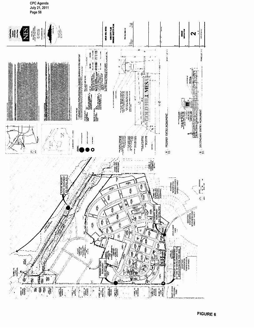
The development of Gold Hill Mesa Filing No. 3 requires Planning Commission approval of seven development applications. Each application, the specific review criteria, and other development issues are described below: Major Amendment to the Gold Hill Mesa Concept Plan (CPC CP 04-00127-A2MJ11) – The Gold Hill Mesa concept plan was originally adopted in 2004. The plan illustrates the project’s land uses, access points, and circulation. It also includes numerous notes regarding: the project’s physical and environmental conditions; the principles of traditional neighborhood development; ownership and maintenance responsibilities; traffic and access; and the phasing of required public improvements. The concept plan serves as a tool to guide the development of the site and evaluate individual development plans when submitted. There are numerous changes to the previously approved concept plan that are reflected on the proposed plan (FIGURE 6). The following paragraphs describe the major types of changes: land use, access/circulation, and notes/obligations. Land Use Changes – Land use designations for multiple areas of the plan were modified to reflect the evolving real estate market.
• A significant area of the TND-zoned residential neighborhood area along Fountain Creek has been changed to PBC-zoned “village commercial mixed use.” This change will allow for the presence of a transitional land use between the US-24 right-of-way and the single-family homes to the south.
• Roughly 3.6 acres of PBC-zoned “village commercial mixed use” northeast of S. 21st Street and Villa De Mesa Dr. has been changed to TND-zoned “townhome attached” housing. This change will provide a better transition from the existing Villa De Mesa neighborhood to the S. 21st Street right-of-way and the commercial uses to the west.
• Some areas of townhomes were changed into single-family residences, while in other areas the opposite occurred. These changes reflect the evolving real estate market while maintaining an appropriate mix of residential land use types required by the TND zone.
Access/Circulation Changes – The plan has been updated to reflect improved access and better circulation.
• Villa De Mesa area – a few changes have been illustrated in the area of Villa De Mesa Road and S. 21st Street. While the previous plan illustrated the realignment of Villa De Mesa Road, the new plan uses shading to clarify that the existing Villa De Mesa Road is being vacated. The access point to S. 21st Street remains the same, but the new alignment will be more direct into Gold Hill Mesa (the westward continuation of Gold Hill Mesa Drive), creating a four-way intersection roughly 300 feet east of S. 21st Street where the new Villa De Mesa Drive will begin and extend north and east into the existing community. The existing concept plan also illustrated a future road extending northward from Villa De Mesa down the hill and connecting into the future commercial area. This vehicular connection has been eliminated (a pedestrian trail remains) due to physical constraints and the desire to minimize conflicts with the Villa De Mesa neighborhood.
• US-24 access – The previously approved plan illustrated a “proposed access” to US-24 aligned with S. 14th St. to the north. There were also two notes on the approved plan regarding the need to coordinate with the Colorado Department of Transportation (CDOT) for approval of the access and the possible need to modify the plan’s circulation should CDOT deny access to US-24. The proposed plan shifts the access point westward to S. 15th Street; this is consistent with the draft US-24 West Environmental
CPC Agenda July 21, 2011 Page 35

Assessment. The new plan also modifies the notes regarding this issue; specifically, a new note is added that clarifies access to US-24 is via a right-in/right-out access, and that once an interchange is constructed at S. 21st Street, the right-in portion of the access must be closed. These changes were reviewed and accepted by CDOT during the project’s internal review stage.
• General circulation - The revised plan illustrates a number of minor changes to the internal circulation plan including a new TND street extending down the slope and through the project’s eastern and northern sections. A new connection is also illustrated just north of the Villa De Mesa neighborhood connecting the Gold Hill Mesa residences to the commercial area to the north.
Notes and Obligations – The plan includes a significant number of notes, tables and phasing plans. A number of changes have been made to these sections of the concept plan:
• The plan’s Public Improvement Phasing Plan has been updated to add a map layer illustrating the extent of each filing to help understand when each public improvement is required.
• The Public Improvement Phasing Plan has been modified to break the obligations for Filing 2 into three sub-categories: Filing 2, Filing 2A, and Filing 2B to recognize how the land within the Filing 2 area has been platted.
• The plan’s phasing maps have been improved, breaking the previously approved map into two unique maps – one for the TND zone and one for the PBC zone.
• The actual obligations have been modified to reflect decisions and agreements that were made since 2004 during the review of individual development plans and plats.
• Notes were added to reflect CDOT’s input on access to US-24. • A few notes that have been fully completed and/or resolved have been retained, but are
now shown with strikethrough and labeled as “completed.” • The TND Land Use Chart has been modified to reflect the same categories that are used
in the City’s TND Design Manual. An application for a major amendment to an approved concept plan must be evaluated using the concept plan review criteria found in section 7.5.501.D. of the City Code. Broad categories to be considered include the project’s effect on general health, welfare and safety of persons in the area; adequacy of light and air; positive land use relationships; adequate public facilities; and adequate transportation network. Additionally, concept plans for TND zoned areas must be evaluated using the criteria found in section 7.3.102.I.5.b. which require the evaluation of the plan’s land use mix, design standard compliance, circulation system, utility distribution, light/signage, statement of overall philosophy, and lastly the project’s phasing. Staff finds that the proposed concept plan amendment is consistent with all of the required criteria and recommends approval with the modifications described at the conclusion of this report.
Zone Change from PBC and PUD to TND (CPC ZC 11-00015) – Three separate zone change applications are necessary in order to implement the proposed land use changes on the concept plan and to rectify the current ownership configuration with zone district designation (FIGURE 7). The first application (CPC ZC 11-00015) changes the zoning of three individual parcels to TND (Traditional Neighborhood Development) so that they can be developed consistently with the rest of the Gold Hill Mesa residential area. The largest and most significant parcel that is proposed to gain the TND zone district is a 3.21-acre piece between the S. 21st Street right-of-way and the Villa De Mesa neighborhood, which was previously zoned PBC (Planned Business Center). The proposed townhome-type development area will serve as a better transitional land use than a commercial PBC land use. A proposed TND zone is evaluated two ways, the standard zone change criteria found in section 7.5.603.B. of the City Code, and using the TND concept plan review criteria found in section 7.3.102.I.5.b. of City Code. Staff finds that the proposed zone change is consistent with the required criteria and recommends approval of the application.
CPC Agenda July 21, 2011 Page 36

Zone Change from PBC/SS, PUD and TND to PBC/SS (CPC ZC 11-00016) – The second zone change application (CPC ZC 11-00016) changes the zoning of roughly 82.15 acres of the site to a new PBC/SS (Planned Business Center with the Streamside Overlay) zone. Much of the subject area is already zoned PBC/SS, but there are two unique areas that are planned as commercial and currently are zoned either TND or PUD. The larger of the two areas is TND zoned and is located at the project’s northeastern corner. The smaller area is a 0.15–acre, PUD-zoned parcel that was previously owned by the Villa De Mesa neighborhood. Over the last few years, Golden Cycle Investments, LLC and the Villa De Mesa Homeowners Association have exchanged numerous properties to correlate ownership with the extent of the Villa De Mesa wall; some of these small parcels must be rezoned to be consistent with the ownership and planned land uses on the larger, adjacent lands. While the proposed PBC/SS zone is fairly large at 82.15 acres, it should be noted that the only land directly impacted by the Streamside Overlay is along the site’s northern edge adjacent to Fountain Creek. The proposed PBC/SS zone is evaluated using the zone change criteria found in section 7.5.603.B. of the City Code. Staff finds that the proposed zone change is consistent with the required criteria and recommends approval of the application.
Zone Change from PBC and TND to PUD (CPC ZC 11-00017) – The third zone change application (CPC ZC 11-00017) is solely to address the current ownership pattern that resulted from recent land swaps between Golden Cycle Investments, LLC, Gold Hill Mesa Partners, LLC, and the Villa De Mesa Homeowners Association. The proposed PUD (Planned Unit Development) zone encompasses 1.23 acres of Villa De Mesa Homeowners Association owned land and is located entirely within the existing/future Villa De Mesa privacy wall. The land use type, height and density of the PUD is described as matching that of the existing Villa De Mesa neighborhood. The proposed PUD zone is evaluated using the standard zone change criteria found in section 7.5.603.B. of the City Code. Staff finds that the proposed zone change is consistent with the required criteria and recommends approval of the application. Vacation of Public Right-of-Way (CPC V 11-00018) – The 1968 Villa De Mesa Filing No. 1 subdivision plat created and conveyed the 80-foot wide public street (Villa De Mesa Drive) that runs east/west just over a 500-foot distance and connects S. 21st Street to the private roads within the Villa De Mesa neighborhood (FIGURE 8). The existing right-of-way does not meet current standards because public rights-of-way must terminate with a cul-de-sac or similar feature to allow the public user to turn around. The concurrent concept plan, development plan and subdivision plat illustrate the creation and conveyance of a new public street (Gold Hill Mesa Drive) that will utilize the same access point to S. 21st Street but will bend southward from the existing Villa De Mesa Drive alignment. A four-way intersection planned roughly 300 feet east of S. 21st Street will provide access into the Villa De Mesa neighborhood via a new private drive, as well as the rest of the Gold Hill Mesa project, to the east and south. Existing utilities within the Villa De Mesa right-of-way will be relocated at Gold Hill Mesa’s expense. The vacation and ultimate realignment of the access into the Villa De Mesa neighborhood is one of the issues that a few of the Villa De Mesa residents object to. Some residents feel that the existing access alignment is best for their residents and that the indirect access may confuse visitors and delay emergency responders. These residents believe that if Gold Hill Mesa residents need access to S. 21st Street, the existing right-of-way and alignment should be used. The City’s traffic engineers have looked closely at this proposal and have concluded that the proposed alignment is the safest and most effective for both Villa De Mesa and Gold Hill Mesa residents.
CPC Agenda July 21, 2011 Page 37

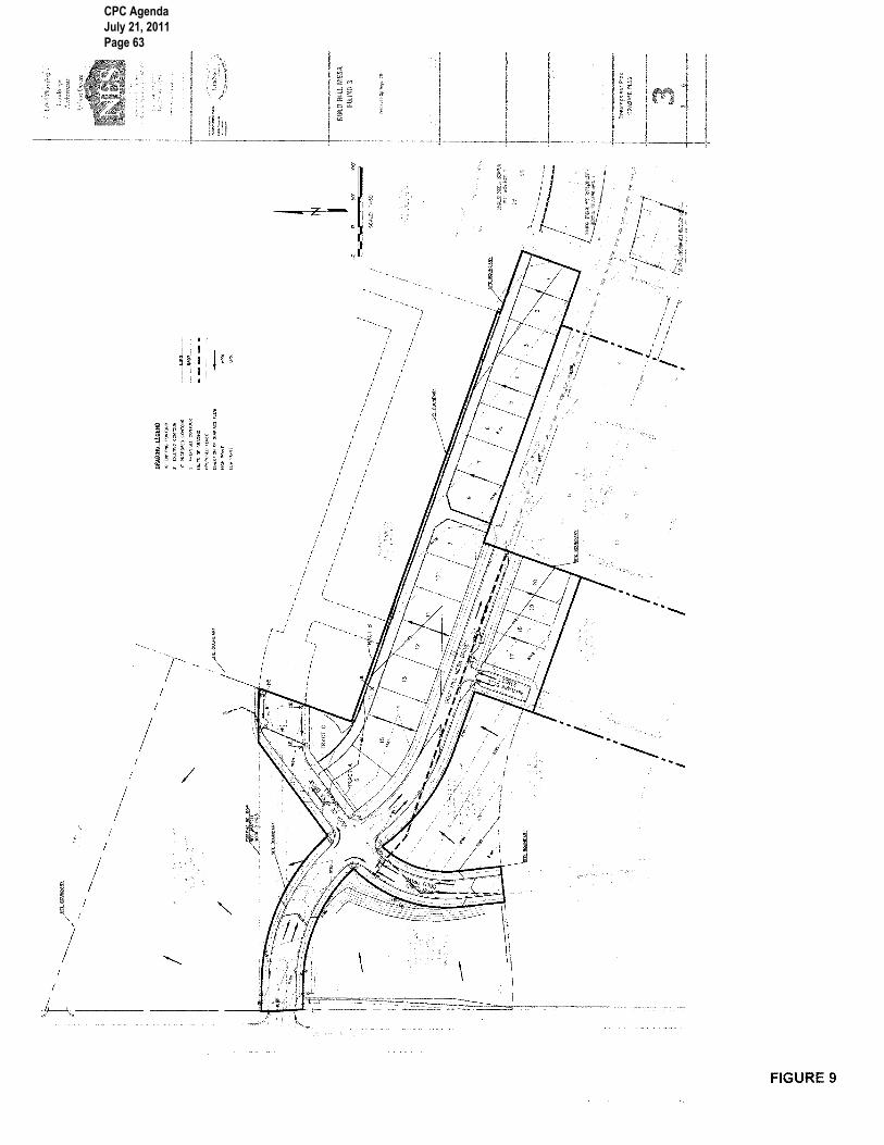
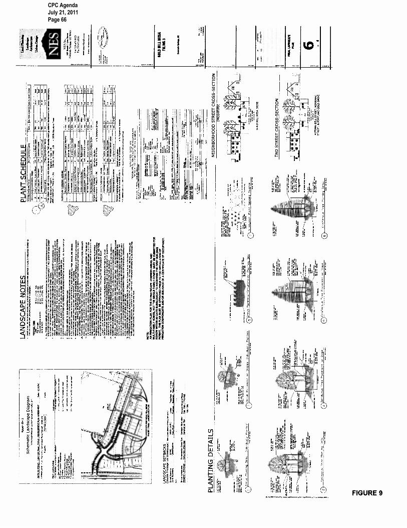
Any request to vacate public right-of-way must be evaluated using the criteria found in Section 7.7.402.C of City Codes. Staff concludes that the required criteria are met and recommends approval of the proposed right-of-way vacation with the modifications described at the conclusion of this report. Gold Hill Mesa Filing No. 3 Development Plan (CPC DP 11-00019) – The development plan for this project is fairly limited compared to the concurrent concept plan. The plan illustrates 20 single-family homes along the north and south sides of Gold Hill Mesa Drive. The plan provides details on the proposed street alignment and width, building envelopes and setbacks on each single-family lot, and includes a landscape plan, utility plan and grading plan. The plan also illustrates three future multi-family development areas with a plan note requiring development plan submittal prior to development of those areas (FIGURE 9). The proposed development plan is relatively straightforward. There were only two significant concerns that arose during review. The original submittal included a 21st lot located on the realigned Villa De Mesa Drive just northeast of the new public alley. The creation of that lot was found by staff to be out of character with the rest of the project and to conflict with the principles of the TND Manual. Furthermore, the creation of the lot was strongly opposed by the Villa De Mesa neighborhood. The applicant resolved this issue by replacing the lot with an open space tract on their revised plans. The second issue is the proposed grading plan and the likely height of the single-family homes on the north side of Gold Hill Mesa Drive. The applicant had previously agreed to limit the impact on the existing southward views from the Villa De Mesa residences. However, when Gold Hill Mesa Drive was constructed, it established a baseline height to which the adjacent lots must drain down to. The result is that a standard two-story home on the north side of the street may have an unacceptable view impact on adjacent properties. In response, the applicant has agreed to restrict at least five of the lots that back up to Villa De Mesa to single story homes. The Villa De Mesa Homeowners Association has accepted this compromise. A TND development plan must be evaluated using the TND development plan criteria found in Section 7.3.102.I.5.d. as well as the standard development plan criteria found in Section 7.5.502.E. of the City Code. Upon careful consideration, staff has determined that the proposed development plan adequately addresses the required review criteria. Staff recommends approval of the proposed development plan with the modifications described at the conclusion of this report. Non-Use Variance (CPC NV 11-00232) – As individual submittals for the development of Gold Hill Mesa have been processed, a few non-use variances have been approved granting relief from a few TND standards. In 2004, a non-use variance was granted allowing single-story homes to have as much as 70% lot coverage where 60% is the limit. In 2007, three non-use variances were granted that allowed: 1) more flexible “build to zones” on individual lots; 2) second-story decks, above a front porch and within the build-to zone, to be enclosed; and 3) accessory dwelling units to be as large as 750 square feet. In reviewing the proposed development plan, Staff realized that the record of decision for these variances included a statement that they only applied to Gold Hill Mesa’s Phase 1. Therefore, new variances must be granted for the proposed phase as well as future phases. The applicant agreed, and submitted a new non-use variance request to address all four design issues. Staff is unaware of any problems associated with the implementation of the previously approved variances; there is reason to think that the TND code could be amended to reflect these issues. A proposed non-use variance must be evaluated using the criteria found in Section 7.5.802.B of the City Code. The criteria require that the site have exceptional or extraordinary conditions that do not apply on surrounding properties, that those properties will not allow reasonable use of the property without relief, and that the granting of relief will not adversely impact surrounding properties. The property is unique in that it is the City’s only TND zoned project, and therefore, has served as a test of the TND standards. While the proposed lots could probably be developed
CPC Agenda July 21, 2011 Page 38

without the requested flexibility, market factors have caused the applicant to determine that the requested relief is necessary; staff does not disagree with this assertion. Lastly, the proposed relief will have no negative impact on surrounding properties. Staff finds that that the request is consistent with the required criteria and recommends approval of all four variances.
2. Conformance with the City Comprehensive Plan: This project is extremely consistent with the City’s Comprehensive Plan objectives, policies and strategies. Those statements that support the proposed project include: Objective LU 2: Develop A Land Use Pattern That Preserves the City's Natural Environment,
Livability, And Sense of Community Strategy LU 203a: Locate the Places that People Use for Their Daily Needs and Activities Close
to Each Other Objective LU 3: Develop A Mix of Interdependent, Compatible, and Mutually Supportive Land
Uses Policy LU 301: Promote a Mixed Land Use Pattern Policy LU 302: Encourage Development of Mixed-use Activity Centers Strategy LU 302b: Promote Pedestrian Orientation of New Activity Centers to the Public Right-of-
Way and Public Spaces Strategy LU 302c: Promote Compatibility between Land Uses of Differing Intensities Objective LU 4: Encourage Infill and Redevelopment Policy LU 401: Encourage Appropriate Uses and Designs for Redevelopment and Infill Projects Strategy LU 502c: Plan Community Activity Centers to Serve Residential Areas Strategy LU 601b: Support a Mixture of Housing Densities Policy LU 602: Integrate Housing with Other Supportive Land Uses Objective LU 7: Develop Shopping and Service Areas to be Convenient to Use and Compatible
with Their Surroundings Strategy LU 702b: Redevelop and Infill Commercial Uses in Mature/Development Corridors to
Form Activity Centers Objective N 2: Enhance Neighborhoods Policy N 201: Protect Established and Stable Neighborhoods Strategy N 203b: Achieve Balanced Mix of Land Uses Strategy N 203c: Support a Mix of Housing Types and Densities Strategy N 203f: Develop Gathering Places Objective N 3: Vary Neighborhood Patterns Policy N 301: Identify and Develop Mutually Supportive Mixed Uses Policy CCA 301: Foster the Character of Individual Areas and Elements within the Community Policy CCA 302: Protect Historical and Cultural Resources Objective CCA 4: Integrate Different Land Uses
3. Conformance with the Area’s Master Plan: The proposed project falls within two master plans: the
1980 Westside Master Plan and the 2004 Gold Hill Urban Renewal Plan. Neither plan provide significant detail or direction for the site. The 1980 Westside Plan pre-dated serious redevelopment efforts and focused on utilizing the site as commercial and high-density residential that takes advantage of the site’s topography, orientation and access to downtown. The 2004 Gold Hill Urban Renewal Plan was also vague as it largely deferred to the Gold Hill Mesa Concept Plan that was utilized to justify and support the TND zone. Ultimately, Staff concludes that the proposed project is consistent with both master plans.
CPC Agenda July 21, 2011 Page 39

STAFF RECOMMENDATIONS: Item No: 4.A CPC CP 04-00127-A2MJ11 – Major Amendment to a Concept Plan Approve the major amendment to the Gold Hill Mesa Concept Plan, based upon the finding that the amendment complies with the concept plan review criteria in City Code Sections 7.5.501.D and 7.3.102I.5.b, and is subject to compliance with the following technical and informational plan modifications:
Technical and Informational Modifications to the Concept Plan: 1. Provide a comprehensive legal description for the extent of the concept plan. 2. Add “clouding” to notes six and 23 to clarify that it has been modified from the previously
approved concept plan. 3. Add “clouding” to clarify the proposed changes to the plan’s tables, charts, and sub-maps. 4. Address the need for alternative compliance relative to the required amount of “civic use and/or
commercial” land use within the TND zone.
Item No: 4.B CPC ZC 11-00015 – Zone Change Approve the proposed TND (Traditional Neighborhood Development) zone for 5.18 acres based upon the finding that the zone complies with the review criteria in City Code Sections 7.5.603.B and 7.3.102.I.5.b.
Item No: 4.C CPC ZC 11-00016 – Zone Change Approve the proposed PBC/SS (Planned Business Center with the Streamside Overlay) zone for 82.15 acres based upon the finding that the zone complies with the review criteria in City Code Section 7.5.603.B.
Item No: 4.D CPC ZC 11-00017 – Zone Change Approve the proposed PUD (type, height and density to match the existing Villa De Mesa PUD) zone, based upon the finding that the zone complies with the review criteria in City Code Section 7.5.603.B.
Item No: 4.E CPC V 11-00018 – Vacation of Public Right-of-Way Approve the vacation of Villa De Mesa Drive based upon the finding that the request complies with the review criteria in City Code Section 7.7.402.C, and is subject to compliance with the following technical and/or informational plan modifications:
Technical and Informational Modifications to the Vacation: 1. Provide a separate legal description of the area to be vacated. 2. Show and label the 80-foot wide area to be retained as public utility easement. 3. Provide a recorded public access easement to verify that access into Villa De Mesa is guaranteed
once the right-of-way is vacated.
CPC Agenda July 21, 2011 Page 40
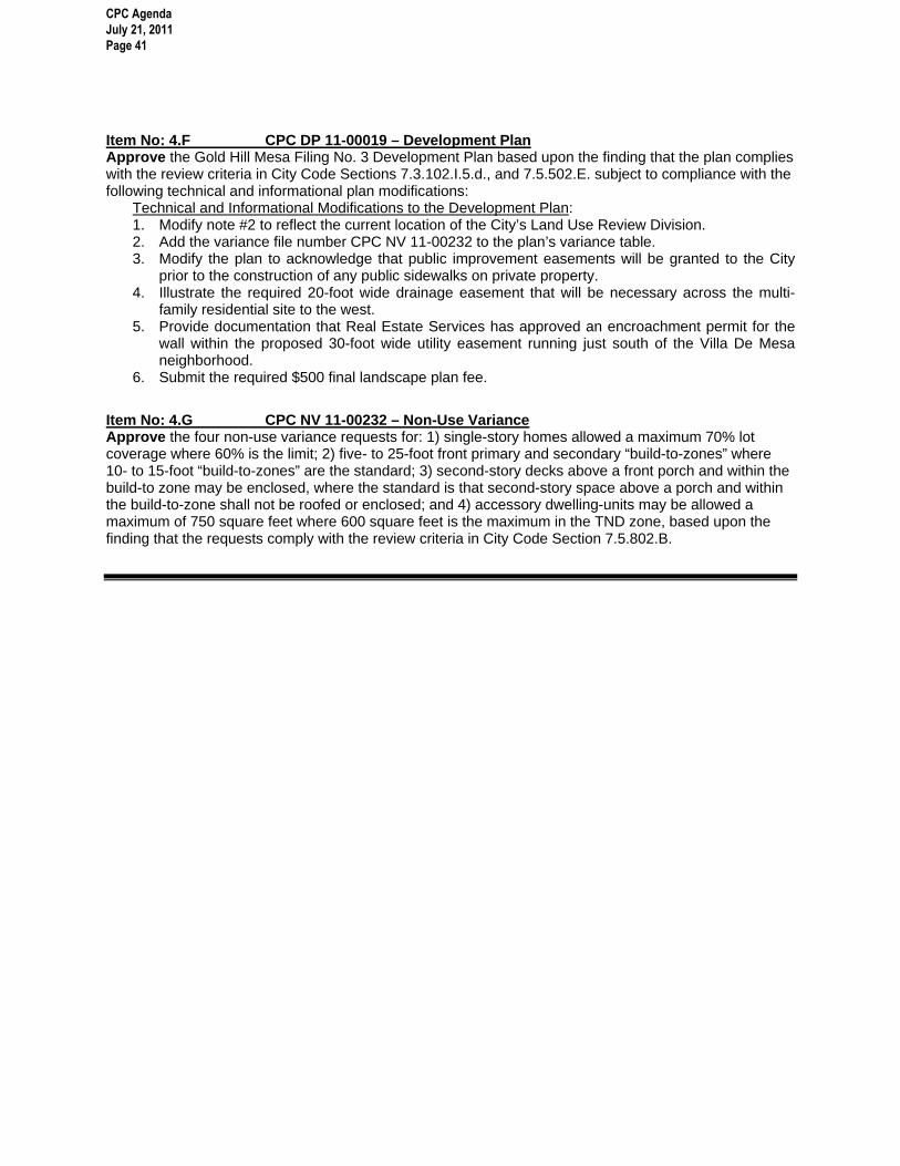
Item No: 4.F CPC DP 11-00019 – Development Plan Approve the Gold Hill Mesa Filing No. 3 Development Plan based upon the finding that the plan complies with the review criteria in City Code Sections 7.3.102.I.5.d., and 7.5.502.E. subject to compliance with the following technical and informational plan modifications:
Technical and Informational Modifications to the Development Plan: 1. Modify note #2 to reflect the current location of the City’s Land Use Review Division. 2. Add the variance file number CPC NV 11-00232 to the plan’s variance table. 3. Modify the plan to acknowledge that public improvement easements will be granted to the City
prior to the construction of any public sidewalks on private property. 4. Illustrate the required 20-foot wide drainage easement that will be necessary across the multi-
family residential site to the west. 5. Provide documentation that Real Estate Services has approved an encroachment permit for the
wall within the proposed 30-foot wide utility easement running just south of the Villa De Mesa neighborhood.
6. Submit the required $500 final landscape plan fee.
Item No: 4.G CPC NV 11-00232 – Non-Use Variance Approve the four non-use variance requests for: 1) single-story homes allowed a maximum 70% lot coverage where 60% is the limit; 2) five- to 25-foot front primary and secondary “build-to-zones” where 10- to 15-foot “build-to-zones” are the standard; 3) second-story decks above a front porch and within the build-to zone may be enclosed, where the standard is that second-story space above a porch and within the build-to-zone shall not be roofed or enclosed; and 4) accessory dwelling-units may be allowed a maximum of 750 square feet where 600 square feet is the maximum in the TND zone, based upon the finding that the requests comply with the review criteria in City Code Section 7.5.802.B.
CPC Agenda July 21, 2011 Page 41

CPC Agenda July 21, 2011 Page 42

CPC Agenda July 21, 2011 Page 43

CPC Agenda July 21, 2011 Page 44

CPC Agenda July 21, 2011 Page 45

CPC Agenda July 21, 2011 Page 46

CPC Agenda July 21, 2011 Page 47

CPC Agenda July 21, 2011 Page 48

CPC Agenda July 21, 2011 Page 49

CPC Agenda July 21, 2011 Page 50

CPC Agenda July 21, 2011 Page 51

CPC Agenda July 21, 2011 Page 52

CPC Agenda July 21, 2011 Page 53

CPC Agenda July 21, 2011 Page 54

CPC Agenda July 21, 2011 Page 55

CPC Agenda July 21, 2011 Page 56

CPC Agenda July 21, 2011 Page 57
CPC Agenda July 21, 2011 Page 58

CPC Agenda July 21, 2011 Page 59

CPC Agenda July 21, 2011 Page 60

CPC Agenda July 21, 2011 Page 61

CPC Agenda July 21, 2011 Page 62
CPC Agenda July 21, 2011 Page 63

CPC Agenda July 21, 2011 Page 64

CPC Agenda July 21, 2011 Page 65
CPC Agenda July 21, 2011 Page 66