Embed Size (px)
Citation preview

Chapter 5.0 Environmental Impacts
CHAPTER 5.0 ENVIRONMENTAL IMPACTS

Draft Environmental Impact Report Oroville Facilities Relicensing—FERC Project No. 2100
This page intentionally left blank.

Chapter 5.0 Environmental Impacts
Page 5.0-1 May 2007
5.0 ENVIRONMENTAL IMPACTS
This chapter of the DEIR identifies potential environmental effects of the alternatives and the associated mitigation measures that avoid, reduce, or compensate for significant impacts. This introduction is intended to provide an overview of the impact methodology and terminology used in the following sections. Specific methodologies for identifying and describing impacts are included in the subsections for the following resource areas:
Geology, Soils, and Paleontological Resources;
Surface Water Quantity and Quality;
Groundwater Quantity and Quality;
Aquatic Resources;
Terrestrial Resources (wildlife and botanical resources);
Land Use;
Recreational Resources;
Cultural Resources;
Population and Public Services (population and housing and public services);
Environmental Justice;
Aesthetic Resources (visual resources and noise);
Air Quality;
Agricultural Resources;
Transportation and Traffic; and
Public Health and Safety (hazardous waste, emergency response, wildland fire).
5.0.1 Program Level versus Project Level
This DEIR evaluates actions included in the Proposed Project and the FERC Staff Alternative at both a program level and project level of impact analysis. Program-level evaluations are conducted on actions that either are more “global” in scale and may occur areawide, or are those actions that were specified in the SA to be developed to a fuller level of detail through the new license implementation period and therefore lack sufficient detail regarding the location, method, or timing of action to support a project-level of analysis. The program-level analyses are intended to fully disclose and

Draft Environmental Impact Report Oroville Facilities Relicensing—FERC Project No. 2100
May 2007 Page 5.0-2
evaluate what is currently known regarding the Proposed Project and FERC Staff Alternative for these actions. Program-level evaluated actions would also be subject to subsequent project-level environmental analysis prior to implementation or construction. As an example, although several potential future facilities modifications are identified and described in the SA, the SA specifies that these (and potentially other future identified alternative facilities modifications) would be further refined and developed in a future Feasibility Study. This DEIR evaluates the general characteristics of the potential future facilities modifications (as they are currently described in the SA) and their potential effects on environmental resources. Because the detailed design and operational characteristics of these (and potentially other) facilities are not yet defined, the analysis of these potential project actions were evaluated at a program level.Further, since the characteristics of these potential facilities modifications are not yet sufficient to support detailed modeling comparisons, scenarios that would include potential future facilities modifications are not included in the DEIR. Some limited modeling and comparisons of the initial new license operating period were conducted, but these alternatives comparisons were conducted at a program level of analysis (see Appendix E).
Many of the actions included in the SA (and therefore, in the Proposed Project and FERC Staff Alternative) would be further developed and refined in the course of the initial new license implementation period, in consultation with appropriate agencies and stakeholders. Most of these actions designed to further protect and enhance environmental resource conditions were evaluated in the DEIR at a program level unless details were included in the SA descriptions. Some of the articles included in the SA describe the development of plans and programs. Plan and program development do not, in and of themselves, typically result in environmental effects. Therefore, those plan and program development activities are not evaluated in this DEIR. See Table 5.0-1 for a list of SA articles and sections included in the Proposed Project and the FERC Staff Alternative that are not evaluated in the DEIR because they have no potential to affect on environmental resources.
5.0.2 Thresholds of Significance and Levels of Significance of Impacts
For each resource area, thresholds of significance are identified; these thresholds, based on the State CEQA Guidelines, are used to determine whether the alternatives would have a significant effect on that resource as compared to the Existing Conditions presented in Chapter 4.0.

Chapter 5.0 Environmental Impacts
Page 5.0-3 May 2007
Table 5.0-1. Settlement Agreement Articles and Sections included in the Proposed Project and/or the FERC Staff Alternative that are not evaluated
in this Draft Environmental Impact Report. SA Article or Section # SA Article/Section Title
APPENDIX A A100 Ecological Committee A101 Lower Feather River Habitat Improvement Plan A109 Reservation of Section 18 Authority A115 Oroville Wildlife Area Management Plan A116 Oroville Wildlife Area Access A130 Flood Control A131 Early Warning System A133 Project Boundary Modifications A134 Expenditures A135 Procedural Requirements APPENDIX B B100 Project Supplemental Benefits Fund
B101 Feather River Whitewater Boating Opportunity Feasibility Study
B104 Feather River Fish Hatchery Funding B105 Gravel Supplementation—Permitting related to A102 B106 Oroville Wildlife Management Plan B108 Flow/Temperature to Support Anadromous Fish B109 Riparian/Floodplain Screening Level Analysis B110 Analysis of Non-Motorized Water Trail Shoreline Access B111 Oroville Wildlife Area Funding APPENDIX C Appendix C Ecological Committee APPENDIX D Appendix D SWRCB Participation Statement APPENDIX E Appendix E Forest Service Draft 4(e) Conditions
Source: Settlement Agreement for Licensing of the Oroville Facilities FERC Project No. 2100,March 2006

Draft Environmental Impact Report Oroville Facilities Relicensing—FERC Project No. 2100
May 2007 Page 5.0-4
In this DEIR, all impacts were evaluated based on the following categories:
No impact indicates that the construction, operation, and maintenance of the project would not have any direct or indirect effects on the environment. It means no change from Existing Conditions. This impact level does not need mitigation.
A beneficial effect is an impact that is considered to cause a positive change or improvement in the environment and for which no mitigation measures are required.
A less-than-significant impact is an adverse impact that would not result in a substantial or potentially substantial adverse change in the physical environment.This impact level does not require mitigation, even if feasible, under CEQA.
A less-than-significant impact with mitigation is a potentially significant adverse impact that would be reduced to less than significant levels with implementation of the identified mitigation measure.
A potentially significant impact is an adverse impact that, if it were to occur, would be considered a significant impact as described above; however, the occurrence of the impact cannot be immediately determined with certainty. For CEQA purposes, a potentially significant impact is treated as if it were a significant impact.
A significant impact is defined by State CEQA Guidelines Section 15382 as an adverse impact that would cause “a substantial, or potentially substantial, adverse change in any of the physical conditions within the area affected by the project.” Under CEQA, mitigation measures or alternatives to the proposed project must be provided, where feasible, to reduce the magnitude of significant impacts.
A significant and unavoidable impact is an impact that would result in a substantial or potentially substantial adverse effect on the environment, and that could not be reduced to a less-than-significant level even with any feasible mitigation. Under CEQA, a project with significant and unavoidable impacts could proceed, but the lead agency would be required to prepare a “statement of overriding considerations” in accordance with State CEQA Guidelines Section 15093, explaining why the lead agency would proceed with the project in spite of the potential for significant impacts.
5.0.3 Mitigation
CEQA requires that feasible mitigation measures be discussed for all significant impacts to avoid or reduce significant adverse effects. Protection, mitigation, and enhancement (PM&E) measures are included in the SA as proposed license articles for FERC’s consideration. As a result of the comprehensive scoping and stakeholder ALP

Chapter 5.0 Environmental Impacts
Page 5.0-5 May 2007
collaborative used for relicensing that included responsible agencies, the majority of SA articles are designed to address the environmental impacts of continued Oroville Facilities operations. The majority of identified impacts associated with implementation of the SA are short-term, construction related, and mitigated through the use of standard Best Management Practices described in Appendix D that are currently standard construction practices followed by DWR during routine operations and maintenance at the Oroville Facilities.

Draft Environmental Impact Report Oroville Facilities Relicensing—FERC Project No. 2100
May 2007 Page 5.0-6
This page intentionally left blank.

Chapter 5.0 Environmental Impacts
Page 5.1-1 May 2007
5.1 GEOLOGY, SOILS, AND PALEONTOLOGICAL RESOURCES
5.1.1 Regulatory Setting
5.1.1.1 Federal Plans, Policies, Regulations, and Laws
Earthquake Hazards Reduction Act
In October 1977, the U.S. Congress passed the Earthquake Hazards Reduction Act to “reduce the risks to life and property from future earthquakes in the United States through the establishment and maintenance of an effective earthquake hazards and reduction program.” To accomplish this, the Act established the National Earthquake Hazards Reduction Program (NEHRP). The National Earthquake Hazards Reduction Program Act (NEHRPA) significantly amended this program in November 1990 by refining the description of agency responsibilities, program goals, and objectives. The NEHRPA designates the Federal Emergency Management Agency as the lead agency of the program and assigns it several planning, coordinating, and reporting responsibilities. Other NEHRPA agencies include the National Institute of Standards and Technology, the National Science Foundation, and the U.S. Geological Survey (USGS).
Erosion and Water Quality
SWRCB and regional water quality control boards (RWQCBs) regulate discharges of waste to water through National Pollutant Discharge Elimination System (NPDES) permits, which are authorized under Section 402 of the federal Clean Water Act (CWA). The permits are issued for discharges to surface waters from such sources as stormwater runoff from general construction activities. The NPDES Construction Activities Storm Water General Permit applies to stormwater discharges associated with construction activity, including clearing, grading, excavation, and reconstruction of existing facilities that could disturb at least 1 acre of land. The NPDES permitting process and other regulatory requirements for the protection of water quality are described in Section 5.2.2.1, Surface Water Quality Regulatory Setting.
Erosion from construction activity would be regulated under the CWA.
Antiquities Act of 1906
Federal protection for significant paleontological resources would apply to the project if any construction or other related project impacts occurred on federally owned or managed lands. Federal legislative protection for paleontological resources stems from the Antiquities Act of 1906 (Public Law 59-209; 16 United States Code 431 et seq.; 34 Stat. 225), which calls for protection of historic landmarks, historic and prehistoric structures, and other objects of historic or scientific interest on federal land.

Draft Environmental Impact Report Oroville Facilities Relicensing—FERC Project No. 2100
May 2007 Page 5.1-2
5.1.1.2 State Plans, Policies, Regulations, and Laws
California Seismic Hazards Mapping Act
The California Seismic Hazards Mapping Act of 1990 (Public Resources Code Sections 2690–2699.6) addresses seismic hazards other than surface rupture, such as liquefaction and induced landslides. The Seismic Hazards Mapping Act specifies that the lead agency for a project may withhold development permits until geologic or soils investigations are conducted for specific sites and mitigation measures are incorporated into plans to reduce hazards associated with seismicity and unstable soils.
Alquist-Priolo Earthquake Fault Zoning Act
The Alquist-Priolo Earthquake Fault Zoning Act (Public Resources Code Section 2621 et seq.) was passed by the California Legislature to mitigate the hazard of surface faulting to structures. The act’s main purpose is to prevent the construction of buildings used for human occupancy on the surface trace of active faults. The act addresses only the hazard of surface fault rupture and is not directed toward other earthquake hazards. Local agencies must regulate most development in fault zones established by the State Geologist. Before a project can be permitted in a designated Alquist-Priolo Earthquake Fault Zone, cities and counties must require a geologic investigation to demonstrate that proposed buildings would not be constructed across active faults.
California Public Resources Code—Archaeological, Paleontological, and Historical Sites
No State or local agency requires a paleontological collecting permit to allow for the recovery of fossil remains discovered as a result of construction-related earthmoving on State or private land in a project site. California Public Resources Code Chapter 1.7 (Archaeological, Paleontological, and Historical Sites), Section 5097.3, specifies that State agencies may undertake surveys, excavations, or other operations as necessary on State lands to preserve or record paleontological resources.
5.1.1.3 Local Plans, Policies, Regulations, and Laws
Butte County General Plan
The Butte County General Plan contains eleven separate documents or elements.Each element sets forth the County's adopted goals, objectives, policies and standards for various issues affecting Butte County. Together these elements make up the ButteCounty General Plan.
The Seismic Safety Element of the General Plan for Butte County carries with it the assumption that available data on seismic risk is described or referenced within the General Plan, and that new information will be added as it becomes known.

Chapter 5.0 Environmental Impacts
Page 5.1-3 May 2007
5.1.2 Impact Thresholds
The following thresholds are used to determine whether the alternatives would have a significant effect on geology, soils, or paleontological resources. There would be a significant impact if the alternatives would:
5.1-a: Result in substantial soil erosion or loss of topsoil, degradation of soils or farmland, or changes in the rate of siltation, deposition, or erosion that could modify channel morphology or habitat use;
5.1-b: Expose people or structures to potential substantial adverse effects, including the risk of loss, injury, or death involving fault rupture, strong seismic ground shaking, seismic-related ground failure including liquefaction, or landslides related to a known earthquake fault as delineated on the most recent Alquist-Priolo Earthquake Fault Zoning Map issued by the State Geologist;
5.1-c: Be located on a geologic unit or soil that is unstable, or that would become unstable as a result of the project, and potentially result in on- or off-site landslide, lateral spreading, subsidence, liquefaction, or collapse;
5.1-d: Be located on expansive soil, as defined in the Uniform Building Code, creating substantial risks to life or property;
5.1-e: Result in the placement of septic tanks or alternative wastewater disposal systems on soils incapable of adequately supporting these systems where sewers are not available for the disposal of wastewater;
5.1-f: Result in the loss of a known mineral resource of value to the region and the residents of the State;
5.1-g: Result in the loss of availability of a locally important mineral resource recovery site delineated on a local general plan, specific plan, or other land use plan; or
5.1-h: Directly or indirectly degrade a unique paleontological resource or site or compromise a significant paleontological site’s scientific and educational values.
5.1.3 Method of Analysis
5.1.3.1 Geomorphic Processes Upstream of Oroville Dam
Potential impacts from the continued operation of the Oroville Facilities upstream of Oroville Dam were analyzed as part of the Environmental Work Group’s Study Plan G-1 (SP-G1). The two primary tasks of SP-G1 were to assess channel resources (both above Lake Oroville and within the Fluctuation Zone) and determine the total sediment in storage by resurveying the existing reservoir cross sections and assessing other geomorphic conditions around the reservoir, such as slope stability, landslides, and bank erosion.

Draft Environmental Impact Report Oroville Facilities Relicensing—FERC Project No. 2100
May 2007 Page 5.1-4
5.1.3.2 Geomorphic Processes Downstream of Oroville Dam
Effects of continued operations of the Oroville Facilities downstream of Oroville Dam were analyzed through the Environmental Work Group’s SP-G2 reports.
The SP-G2 Task 2 report entitled Spawning Riffle Characteristics includes the methodology, results, and conclusions of a Chinook salmon spawning riffle quality evaluation. The riffle sampling and testing was performed by DWR Northern District Geology staff during the fall of 2002 and 2003. Riffle sampling data collected included surface and subsurface bed material, temperature, permeability, and dissolved oxygen. Riffles were sampled in the lower Feather River between Oroville and Honcut Creek.
Results from this study were used to identify ongoing channel changes and develop a comprehensive sediment management plan for the purposes of protection, mitigation, and enhancement measures to improve form and function in the Feather River. The study results were used by other studies to help assess the project’s ongoing effects on downstream water quality, aquatic and riparian resources, and protection of private lands and public trust resources. (SP-G2 Task 3)
The first half of the SP-G2 Task 5 report focused on collecting existing survey, topographic, and photographic data. It also plotted channel locations for the years available on the atlas and the Geographic Information System (GIS). Changes in channel location, islands, multiple channel areas, levees, and riprap were delineated. The second half of the report focused on determining the effect of project operations on channel geomorphology. This was done by using geologic maps in conjunction with aerial photo interpretation to identify structural controls on river erosion and plan form.These aerial photos and old survey maps were used to establish the location of historic river channels and used to establish the extents of the meander belt. Available past cross-sectional data was also compared to those surveyed in Task 3 to determine changes in channel shape, form, and function caused by the dam. Finally, changes in depth, width, hydraulic radius, roughness, gradient, pool-riffle-run ratio, and other hydraulic parameters were determined. (SP-G2 Task 5)
The SP-G2 Task 6 geomorphic report compares historic and current conditions to help identify ongoing project effects to channel meander and bank erosion in the downstream reach defined in this study. This information was used by other studies to help assess the project’s effects on plant, fish, animal, and riparian resources. This data, together with other study results, provided boundary conditions for assessing potential management actions.
Project-related structures and operations alter flow regimes, which can affect the occurrence of geomorphically significant flows. The Task 6 report addresses potential adverse effects from these flows, including changes in the rate of channel meander and bank erosion. (SP-G2 Task 6)
The SP-G2 Task 7 report contains information describing the modeling effort undertaken to determine ongoing and future changes in stream geomorphology and

Chapter 5.0 Environmental Impacts
Page 5.1-5 May 2007
sediment transport. Major items that required calibration included the roughness coefficient, sediment transport equation, and the bank erodibility factor. The model was run using a number of different sediment transport equations. The Engelund-Hansen equation was selected because the results most closely resembled sediment transport data measured by USGS (1978). The model was calibrated by comparing changes in surveyed cross sections between 1972 and 1997, and by comparing observed and calculated water-surface profiles. Hydrologic data from 1972 to 1997 were used for calibration. The model was then run to predict conditions 50 years in the future.Hydrologic data from 1997 to 2002, followed by 1967 to 2002, and 1967 to 1977, were used to model the 50-year changes. (SP-G2 Task 7)
5.1.3.3 Soils
The data for the Feather River soils within the 100-year floodplain, below Thermalito Diversion Dam, were gathered from various resources. Data for Yuba and Sutter Counties were collected form the Natural Resources Conservation Service, and the partial coverage of Butte County was supplied by the DWR Northern District wetlands survey project.
5.1.3.4 Paleontological Resources
Information presented in this section was derived primarily from Paleontological Resources in the Vicinity of FERC Project 2100 [Oroville Reservoir and Lower Feather River]: Literature-based Inventory and Significance Assessment (Hanson 2003). As the study title indicates, this is a primarily literature-based inventory prepared for the Oroville Facilities Relicensing. The presence of fossils and fossil-bearing geological formations within the study area was assessed in this study through professional examination of published and unpublished literature, examination of museum collections and associated records of fossil finds, and interviews with persons familiar with the geology and paleontology of the study area. Known fossil locations within the study area are documented in the study. The study also identifies geological formations that have produced fossils elsewhere, but for which there have not yet been any documented fossil finds within the project area.
General potential impacts were assessed on the basis of potential impact areas (identified on the basis of erosion modeling, areas with other sorts of project operational impacts, and plans for recreational development) and general sensitivity areas in terms of potentially important geological formations.
5.1.4 Impacts and Mitigation Measures
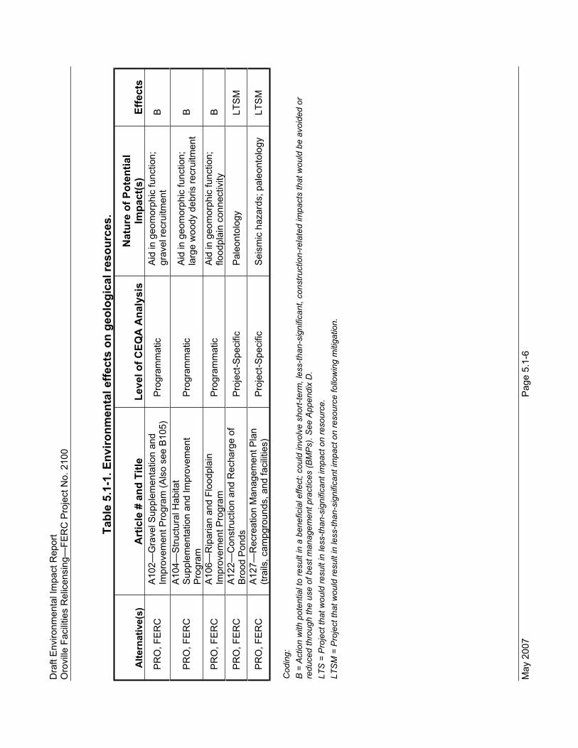
This DEIR analyzes the No-Project Alternative, the Proposed Project, and the FERC Staff Alternative including both programmatic and project-level analyses. Table 5.1-1 indicates the actions that could have an effect on geological resources, and whether these effects are expected to be beneficial, less-than-significant, or would be less-than-significant following implementation of recommended mitigation measures. Impacts on
Dra
ft E
nviro
nmen
tal I
mpa
ct R
epor
t O
rovi
lle F
acilit
ies
Rel
icen
sing
—FE
RC
Pro
ject
No.
210
0
May
200
7 P
age
5.1-
6
Tabl
e 5.
1-1.
Env
ironm
enta
l effe
cts
on g
eolo
gica
l res
ourc
es.
Alte
rnat
ive(
s)A
rtic
le #
and
Titl
e Le
vel o
f CEQ
A A
naly
sis
Nat
ure
of P
oten
tial
Impa
ct(s
) Ef
fect
s
PR
O, F
ER
C
A10
2—G
rave
l Sup
plem
enta
tion
and
Impr
ovem
ent P
rogr
am (A
lso
see
B10
5)
Pro
gram
mat
ic
Aid
in g
eom
orph
ic fu
nctio
n;
grav
el re
crui
tmen
t B
PR
O, F
ER
C
A10
4—S
truct
ural
Hab
itat
Sup
plem
enta
tion
and
Impr
ovem
ent
Pro
gram
Pro
gram
mat
ic
Aid
in g
eom
orph
ic fu
nctio
n;
larg
e w
oody
deb
ris re
crui
tmen
t B
PR
O, F
ER
C
A10
6—R
ipar
ian
and
Floo
dpla
in
Impr
ovem
ent P
rogr
am
Pro
gram
mat
ic
Aid
in g
eom
orph
ic fu
nctio
n;
flood
plai
n co
nnec
tivity
B
PR
O, F
ER
C
A12
2—C
onst
ruct
ion
and
Rec
harg
e of
B
rood
Pon
ds
Pro
ject
-Spe
cific
P
aleo
ntol
ogy
LTS
M
PR
O, F
ER
C
A12
7—R
ecre
atio
n M
anag
emen
t Pla
n (tr
ails
, cam
pgro
unds
, and
faci
litie
s)
Pro
ject
-Spe
cific
S
eism
ic h
azar
ds; p
aleo
ntol
ogy
LTS
M
Cod
ing:
B
= A
ctio
n w
ith p
oten
tial t
o re
sult
in a
ben
efic
ial e
ffect
; cou
ld in
volv
e sh
ort-t
erm
, les
s-th
an-s
igni
fican
t, co
nstru
ctio
n-re
late
d im
pact
s th
at w
ould
be
avoi
ded
or
redu
ced
thro
ugh
the
use
of b
est m
anag
emen
t pra
ctic
es (B
MP
s). S
ee A
ppen
dix
D.
LTS
= P
roje
ct th
at w
ould
resu
lt in
less
-than
-sig
nific
ant i
mpa
ct o
n re
sour
ce.
LTS
M =
Pro
ject
that
wou
ld re
sult
in le
ss-th
an-s
igni
fican
t im
pact
on
reso
urce
follo
win
g m
itiga
tion.

Chapter 5.0 Environmental Impacts
Page 5.1-7 May 2007
geologic resources from implementing the FERC Staff Alternative are similar to those anticipated from implementation of the Proposed Project, unless noted. Potential impacts are identified as follows: NO (No-Project), PRO (Proposed Project), and FERC (FERC Staff Alternative).
The Proposed Project includes programs and agreements that would result in beneficial effects on the channel-forming geomorphic processes present in the dynamic Feather River system such as gravel supplementation and large woody debris (LWD) and boulder placement to increase channel complexity. The Habitat Expansion Agreement (SA Appendix F) could include restoration activities within river channels that could also help restore functionality.
DWR performed a reconnaissance study of potential future facility modifications as described in the Proposed Project (SA Section B108) designed to study ways to provide colder water to the lower Feather River for even greater protection and enhancement of beneficial uses. The reconnaissance study, conducted to address water temperature habitat needs for anadromous fisheries in the Low Flow Channel (LFC) and the High Flow Channel (HFC), was completed in December 2006 and identified a number of conceptual actions that would be further studied for feasibility, individually or in concert with one another. Any measures recommended for potential implementation as a result of the feasibility study would be subject to future CEQA analysis.
With the exception of the No-Project Alternative, alternatives analyzed would result in less-than-significant impacts on geologic resources with the implementation of best management practices (BMPs) included in both the Proposed Project and the FERC Staff Alternative and as described in Appendix D, to address short-term, construction-related impacts and no further mitigation would be required.
5.1.4.1 Program-Level Impacts and Mitigation Measures
With implementation of the No-Project Alternative, baseline conditions identified in Section 4.1.2, Environmental Setting, would continue into the future. In general, existing Oroville Facilities operations and maintenance activities would remain the same as under Existing Conditions. There would be, however, some effects on geologic, geomorphic, and soils-related resources within the study area due to continued existing operational activities. These include effects on flood damage reduction, channel morphology, and geomorphic function.
Several of the baseline incremental effects identified in the No-Project Alternative are addressed under the Proposed Project. These consist of various aspects of channel morphology and geomorphic function, including gravel recruitment, sediment transport, LWD recruitment, and channel complexity. The Proposed Project also addresses channel habitat abundance and diversity.

Draft Environmental Impact Report Oroville Facilities Relicensing—FERC Project No. 2100
May 2007 Page 5.1-8
Impact 5.1-a: Result in substantial soil erosion or loss of topsoil, degradation of soils or farmland, or changes in the rate of siltation, deposition, or erosion that could modify channel morphology or habitat use.
NO Regular intermediate flood flushing flows to maintain geomorphic function of the river and replenish fish and riparian habitats are generally rare. With implementation of the No-Project Alternative, there would continue to be an effect on the natural geomorphic processes (channel migration, floodplain renewal/interconnectivity, and point bar development) of the Feather River below Oroville Dam and this would be considered potentially significant.
Upstream gravel recruitment contribution continues to be blocked and results in continued changes to substrate quality and streambed armoring. This includes the incremental loss of sediment (particularly coarse sands and gravels) in the lower Feather River as a result of the continued blockage by the Oroville Facilities and other Upper Feather River hydroelectric projects, as indicated in the FLUVIAL-12 Sediment Transport Modeling (SP-G2, Task 7) and would be considered potentially significant.
Continued transport blockage to the lower Feather River of LWD contributed upstream of Oroville Dam results in continued incremental reduction in habitat quality and complexity in the lower Feather River described in Existing Conditions. LWD recruitment, which plays an important role in gravel retention and channel morphology, is limited in the LFC by the Oroville Facilities under the No-Project Alternative resulting in a potentially significantimpact.
With the implementation of the No-Project Alternative, there would continue to be a beneficial effect because the reduction in natural, high-volume flow events (e.g., spring snowmelt runoff, winter flooding) has caused a significant reduction in channel erosion and property loss along the lower Feather River below Oroville Dam.
One of the primary functions of the Oroville Dam is to store winter and spring runoff, which has in turn altered the natural flow regime in the river below the dam. One of the results of a regulated flow regime is that there has been an increase in development and urbanization within the river’s natural floodplain (both outside and inside levees). The attenuation of peak flood flows, which in the northern Sierra Nevada Geomorphic Province are typically associated with winter storms and spring snowmelt, has generally resulted in decreased rates of bank erosion and a reduction on the rate of channel migration. (SP-G2, Tasks 5 and 7) While there has continued to be incremental sediment loss in the lower

Chapter 5.0 Environmental Impacts
Page 5.1-9 May 2007
Feather River (discussed above), the results of the operation of the Oroville Facilities have reduced the average rates of erosion, and therefore reduced overall property losses along the river. This is a beneficial effect.
PRO, FERC The Structural Habitat Supplementation and Improvement Program (SA Article A104) would provide some floodplain renewal/interconnectivity and placement of LWD and boulders. With the Gravel Supplementation and Improvement Program (SA Article A102), placement of gravel within the Feather River system downstream of Oroville Dam would address loss of geomorphic function resulting from the ongoing presence of the Oroville Facilities and would be beneficial.
With implementation of the Proposed Project, there would be beneficial effects on the natural geomorphic processes on the Feather River below Oroville Dam. These include increased gravel recruitment and sediment transport with the implementation of the Gravel Supplementation and Improvement Program.
The Proposed Project would improve LFC complexity and provide long-term beneficial effects through the Structural Habitat Supplementation and Improvement Program and the Riparian and Floodplain Improvement Program (SA Articles A104 and A106).
With respect to soil erosion and property loss, the Proposed Project and FERC Staff alternative are the same as the No Project.
Impacts of the Proposed Project Relative to Existing Conditions
The Gravel Supplementation and Improvement Program (SA Article A102) is designed to mitigate the effects of sediment trapping and flow management caused by Oroville Dam. The program proposes to directly place appropriate-sized spawning gravel directly on riffles that have become coarsened and armored.
The riffles in the LFC from the Fish Barrier Dam to Thermalito Afterbay Outlet can be accessed from DWR-owned land except for Bedrock Park Riffle in downtown Oroville.Access would be from levees and roadways that remain from activities that occurred during construction of Oroville Dam. Any undisturbed areas remaining after the extensive previous construction disturbance can be avoided. Sensitive areas of riparian vegetation, including elderberry shrubs, would also be avoided to the extent feasible.
Instream gravel placement would occur only during the approved timing windows for performing instream work to minimize disturbance to anadromous fish. Instream work would be performed using rubber-tired equipment to minimize the amount of

Draft Environmental Impact Report Oroville Facilities Relicensing—FERC Project No. 2100
May 2007 Page 5.1-10
disturbance. Gravel would be washed to reduce the occurrence of fines. BMPs would be used to reduce the potential occurrence of hydrocarbon leaks and spills. See Appendix D for descriptions of BMPs that are included in the Proposed Project.
5.1.4.2 Project-Level Impacts and Mitigation Measures
This section addresses those specific proposed projects that would have geologic impacts as defined by the thresholds of significance section as required by CEQA.
Impact 5.1-a: Result in substantial soil erosion or loss of topsoil, degradation of soils or farmland, or changes in the rate of siltation, deposition, or erosion that could modify channel morphology or habitat use.
PRO, FERC Specific projects that involve earth-moving actions would be susceptible to increased erosion. Areas that could be particularly susceptible to increased erosion are the Middle Fork and South Fork arms of Lake Oroville where soils developed on the underlying granitic bedrock; however, few activities are planned in these areas. Since these soils can be highly erodible, BMPs as described in Appendix D and part of both the Proposed Projectand the FERC Staff Alternative, would be implemented to prevent or reduce:
Erosion, removal, disturbance, and compaction or shifting of gravels in the Feather River channel downstream of the Fish Barrier Dam, except as appropriate for protection or improvement of fish habitat;
Discharge of silt, petroleum hydrocarbons, and other harmful substances or debris into the Feather River;
Construction of new facilities on or near areas prone to landsliding or highly erodible soils; and
Changes to Oroville Facilities borrow areas (e.g., historic, current, and/or future gravel mining areas) that cause them to become sources of silt or other fines during floods or to dissipate stream maintenance flows or trap anadromous fish.
With the BMPs identified as part of the both the Proposed Project and the FERC Staff Alternative, the impacts from increased erosion would be less-than-significant.
Impact 5.1-b: Expose people or structures to potential substantial adverse effects, including the risk of loss, injury, or death involving fault rupture, strong seismic ground shaking, seismic-related ground failure including liquefaction, or landslides related to a

Chapter 5.0 Environmental Impacts
Page 5.1-11 May 2007
known earthquake fault as delineated on the most recent Alquist-Priolo Earthquake Fault Zoning Map issued by the State Geologist.
NO, PRO, FERC The 1975 Oroville Earthquake occurred on the Cleveland Hills Fault. The surface rupture on this fault extended to about 3 miles south of Lake Oroville and is mapped under the Alquist-Priolo Act on the Bangor 7.5’ Quadrangle. The linement along which the rupture occurred is mapped to the south end of the cove containing the Bidwell Marina. Although this area did not experience surface rupture, existing facilities and any facilities proposed under the Proposed Project and the FERC Staff Alternative in this area could be subject to earthquake-generated rupture. This would be considered potentially significant.
Mitigation measure 5.1-b:
PRO, FERC Perform geologic investigation of any facilities proposed in the Bidwell Marina (SA Article A127) area to ensure adequate setback from possible lineaments associated with the active Cleveland Hills Fault. Implementation of Mitigation Measure 5.1-b would reduce the impact to less-than-significant.
Impact 5.1-c: Be located on a geologic unit or soil that is unstable, or that would become unstable as a result of the project, and potentially result in on- or off-site landslide, lateral spreading, subsidence, liquefaction, or collapse.
PRO, FERC The map of proposed facilities locations was superimposed with the landslide map prepared under the Environmental Work Group’s SP-G1. None of the currently proposed facilities conflict with any known landslides. There should be no impact from landsliding.
Impact 5.1-d: Be located on expansive soil, as defined in the Uniform Building Code, creating substantial risks to life or property.
NO, PRO, FERC Expansive soils have not been identified in the project area.
Impact 5.1-e: Result in the placement of septic tanks or alternative wastewater disposal systems on soils incapable of adequately supporting these systems where sewers are not available for the disposal of wastewater.
NO,PRO, FERC No septic systems are proposed. There should be no impact from septic systems.
Impact 5.1-f: Result in the loss of a known mineral resource of value to the region and the residents of the State.

Draft Environmental Impact Report Oroville Facilities Relicensing—FERC Project No. 2100
May 2007 Page 5.1-12
PRO, FERC The Gravel Supplementation and Improvement Program (SA Article A102) includes provisions for potential utilization of gravel/aggregate resources. There should be no impact onmineral resources statewide.
Impact 5.1-g: Result in the loss of availability of a locally important mineral resource recovery site delineated on a local general plan, specific plan, or other land use plan.
PRO, FERC The Gravel Supplementation and Improvement Program (SA Article A102) includes provisions for potential utilization of gravel/aggregate resources. There should be no impact on the Mineral Resource Local Plan.
Impact 5.1-h: Directly or indirectly degrade a unique paleontological resource or site or compromise a significant paleontological site’s scientific and educational values.
PRO, FERC There are three areas that could be sensitive to disturbance to paleontological resources. These are in the vicinity of Lime Saddle where the blocks of Calaveras Limestone in the mélange sequence are known to contain fossils; an area about halfway along the Diversion Pool that is crossed by an outcrop of the Monte del Oro Formation that is known to contain fossils; and the vicinity of Thermalito Forebay and Thermalito Afterbay that overlie the Laguna Formation that in other places is known to contain vertebrate fossils. Actions in the Proposed Project and the FERC Staff Alternative that are proposed for these areas (i.e. SA Article A122 and Article A127) could involve earth-moving activities with the potential to disturb paleontological resources and could result in a potentially significant impact.
Mitigation measure 5.1-h:
PRO, FERC Screen for the presence of fossils as plans are finalized for actions near known paleontological resources. If avoidance is not possible, have plans in place for the recovery/preservation of any fossils encountered. With screening and a recovery/preservation plan as described, any impacts would be reduced to less-than-significant.
Chapter 5.0 Environmental Impacts
Page 5.2-1 May 2007
5.2 SURFACE WATER
5.2.1 Surface Water Quantity
5.2.1.1 Regulatory Setting
As part of the relicensing process, DWR must comply with federal and State laws that are relevant to the relicensing of the Oroville Facilities. A summary of potentially relevant federal and State laws and regulations relating to surface water quantity is provided below.
Federal Plans, Policies, Regulations, and Laws
U.S. Army Corps of Engineers Flood Storage Requirements under the Flood Control Act of 1958 (Act of Congress, Public Law 85-500, 72 Stats. 297)
During fall, winter, and spring, the Oroville Facilities are operated under flood control requirements specified by the U.S. Army Corps of Engineers (USACE) in accordance with the provisions of the Flood Control Act of 1958. Under these requirements, Lake Oroville is operated to maintain up to 750,000 acre-feet (af) of flood storage space to allow for the capture of significant flood inflows.
Fish and Wildlife Coordination Act (16 United States Code 661 et seq.)
The purpose of this act is to recognize the contribution of fish and wildlife resources to the nation. The goal is to ensure that fish and wildlife conservation receives equal consideration and is coordinated with other features of water resources development programs. The statute provides that whenever the waters of any stream or other body of water are proposed to be impounded or diverted, or the channel deepened or otherwise controlled or modified, the responsible federal agency shall consult with USFWS and/or NMFS, as appropriate. DFG comments are also incorporated into the Fish and Wildlife Coordination Act report, which is then forwarded to the responsible agency.
Federal Power Act Section 10(j)
Under the provisions of Section 10(j) of the Federal Power Act (FPA), each hydroelectric license issued by FERC is required to include conditions for the protection, mitigation, and enhancement of fish and wildlife resources affected by the project as may be recommended by NMFS, USFWS, and DFG, to the extent that FERC determines that such recommendations are not inconsistent with the FPA. Compliance with the Fish and Wildlife Coordination Act is coordinated through the 10(j) recommendations.

Draft Environmental Impact Report Oroville Facilities Relicensing—FERC Project No. 2100
May 2007 Page 5.2-2
Federal Endangered Species Act
Section 7 of the federal Endangered Species Act requires federal agencies to ensure that their actions are not likely to jeopardize the continued existence of endangered and threatened species or to cause destruction or adverse modification of the critical habitat of such species. FERC must consult with USFWS and NMFS under Section 7.
State Plans, Policies, Regulations, and Laws
California Fish and Game Code Section 1602 (Streambed Alteration)
Section 1602 of the California Fish and Game Code states that any entity proposing to substantially divert or obstruct the natural flow or alter streambed materials, channel, or bank in any river, stream, or lake must obtain a Lake and Streambed Alteration Agreement from DFG. The application requires a detailed description of the proposed project location and map, name and description of the river, stream, or lake affected by streamflow diversions, and copies of applicable local, State, or federal permits and/or other documents already issued.
California Fish and Game Code Section 5937 (Flows Below Dams)
Section 5937 of the California Fish and Game Code states that the owner of any dam must provide sufficient water at all times through a fishway, or in the absence of a fishway, allow sufficient water to pass over, around or through the dam, to keep any fish below the dam “in good condition.”
State Water Code
The Davis-Dolwig Act, California Water Code Section 11900, states that it is necessary for the general public health and welfare that preservation of fish and wildlife be provided for in connection with the construction of State water projects. It further declares that State facilities for the storage, conservation, or regulation of water must be constructed in a manner consistent with the full utilization of their potential for the enhancement of fish and wildlife and to meet recreational needs.
Water Code Section 1375 et seq. authorizes the SWRCB to issue water rights permits and licenses. The SWRCB has issued four water rights permits to DWR covering the operation of the Oroville Facilities: (a) Two permits, P-16477 and P-16480, allow the use of up to 11,000 cubic feet per second (cfs) of direct diversion and up to 3,880,000 acre-feet per year diversion to storage for power generation at the Oroville Facilities, including incidental recreation and fish and wildlife enhancement; and (b) two permits, P-16478 and P-16479, allow the use of the same quantities of water for consumptive use purposes.
State Water Project Statutes
Central Valley Project Act. In 1933, the California Legislature enacted, and the voters approved in a referendum, the State CVP Act (Water Code Section 11100 et seq.). The

Chapter 5.0 Environmental Impacts
Page 5.2-3 May 2007
State CVP Act provided for the implementation of a statewide water project in California’s Central Valley. However, due to lack of funds available to the State during the Depression of the 1930s, the United States government built the federal CVP, which is operated by the U.S. Bureau of Reclamation. The State CVP Act, however, now governs the construction, operation, and administration of the subsequently constructed SWP, which gained its impetus from voter approval of the Burns-Porter Bond Act, discussed below.
Burns-Porter Bond Act. In the 1950s, the Legislature authorized construction of initial facilities of the SWP, commencing with construction of facilities in the Oroville area in 1957. However, it was the enactment by the Legislature and approval by the voters in 1960 of the Burns-Porter Bond Act (entitled the California Water Resources Development Bond Act, Water Code Sections 12930–12944) that provided major funding through the authorization of $1.75 million in general obligation bonds for construction of the initial features of the SWP. Since the late 1960s, DWR has also issued revenue bonds pursuant to authority contained in the State CVP Act to finance construction of additional SWP facilities. Both the Burns-Porter general obligation bonds and the CVP revenue bonds are repaid through SWP revenues.
5.2.1.2 Impact Thresholds
The following thresholds are used to determine whether the alternatives would have a significant effect on surface water quantity. There would be a significant impact if the alternatives would:
5.2.1-a: Substantially alter an existing drainage pattern of the site or area, including alteration of the course of a stream or river, or a substantial increase in the rate or amount of surface runoff in a manner that would result in flooding on- or off-site; or
5.2.1-b: Create or contribute to runoff water exceeding the capacity of existing or planned stormwater drainage systems or provision of substantial additional sources of polluted runoff.
5.2.1.3 Method of Analysis
During the course of the environmental studies for relicensing, extensive computer-based operations simulation modeling was performed. The models developed and methodologies used to simulate existing and future operations under a wide variety of assumed conditions are detailed in Volume III, Appendix C, of the PDEA. That appendix describes the analytical modeling tools and evaluation procedures that were used to support the PDEA and characterize project-related effects on reservoir and river hydrology, as well as other selected modeling tools that were used to assess environmental impacts. Since there would be no changes in net releases from the facilities or changes to future allocation patterns, the modeling results utilized in the PDEA are equally applicable to the No-Project, Proposed Project, and FERC Staff Alternatives; therefore, no additional comparison is necessary. The hydrologic results

Draft Environmental Impact Report Oroville Facilities Relicensing—FERC Project No. 2100
May 2007 Page 5.2-4
also served as important information for the evaluation of power production, flood management, water quality, fisheries, recreation, and economic impacts.
The following operation, temperature, and sediment models were used to perform the environmental analysis of the various alternatives included in the PDEA:
CALSIM II: Modeled the SWP and CVP using a monthly time step. Allowed for assessment of water supply impacts and provides operational constraints for the other operations models.
Local Operations (HYDROPSTM): Modeled Oroville Facilities operations at an hourly time step with the goal of maximizing hydroelectric power production given input constraints.
Reservoir–River Temperature (WQRRS): Modeled temperatures in the Oroville–Thermalito Complex and in the Feather River, from the base of Oroville Dam extending downstream to its confluence with the Sacramento River.
Flow-Stage (HEC-RAS): Modeled channel geometry and flow resistance to develop flow-stage relationships along the Feather River from the base of Oroville Dam extending downstream to its confluence with the Sacramento River.
FLUVIAL-12: Modeled sediment movement in the Feather River to provide input to the analysis of scour and erosion within the river.
5.2.1.4 Impacts and Mitigation Measures
As stated in Chapter 3.0 of the PDEA that accompanied the FERC License Application, no modifications to project operations related to surface water flow ramping rates, water supply, or flood management were proposed for any of the alternatives evaluated (DWR 2005). The SA includes provisions for future increases in minimum flows and potential greater increases in flows for water temperature management in the Low Flow Channel (LFC) to support anadromous fish and other beneficial uses; however, it would not increase net facility releases in the Proposed Project. The No-Project Alternative and FERC Staff Alternative are consistent with future water supply allocations. The only changes to net facility releases are in response to future changes in allocations or release timing. These changes apply equally to the No-Project, Proposed Project, and FERC Staff Alternatives evaluated in the DEIR.
In addition to the Proposed Project, this DEIR analyzes the No-Project Alternative and the FERC Staff Alternative. All alternatives analyzed result in no impacts on surface water quantity.

Chapter 5.0 Environmental Impacts
Page 5.2-5 May 2007
Impact 5.2.1-a: Substantially Alter an Existing Drainage Pattern of the Site or Area, Including Alteration of the Course of a Stream or River, or a Substantial Increase in the Rate or Amount of Surface Runoff in a Manner that Would Result in Flooding On- or Off-Site.
There are no measures that have the potential to substantially alter an existing drainage pattern of the site or area, including alteration of the course of a stream or river, or a substantial increase in the rate or amount of surface runoff in a manner that would result in flooding on- or off-site, with the exception of the possibility for planned flooding of previously disconnected floodplain during implementation of the Riparian and Floodplain Improvement Program. However, no specific actions or locations have been identified for consideration for inclusion in this program.
Impact 5.2.1-b: Create or Contribute to Runoff Water Exceeding the Capacity of Existing or Planned Stormwater Drainage Systems or Provision of Substantial Additional Sources of Polluted Runoff.
There are no measures that have the potential to create or contribute to runoff water exceeding the capacity of existing or planned stormwater drainage systems or provision of substantial additional sources of polluted runoff. Most construction activities would occur at previously developed locations with adequate stormwater runoff drainage systems in place and would include Best Management Practices (BMPs) to control and contain construction-related runoff. New facilities to be built in previously undisturbed locations would include stormwater drainage systems consistent with State building standards. Trails would be planned to consider drainage and include stormwater drainage systems as necessary to avoid exceeding drainage system capacities and prevent substantial additional polluted runoff.
Draft Environmental Impact Report Oroville Facilities Relicensing—FERC Project No. 2100
May 2007 Page 5.2-6
5.2.2 Surface Water Quality
5.2.2.1 Regulatory Setting
The quality of surface water resources in California is protected under various federal and State laws, including the federal Clean Water Act (CWA) and the State Porter-Cologne Water Quality Control Act (Porter-Cologne Act). The U.S. Environmental Protection Agency (USEPA) has authorized the SWRCB and the nine associated regional water quality control boards (RWQCBs) to administer all surface water quality regulations in California. Both USEPA and the SWRCB provide oversight, while the RWQCBs have primary responsibility for implementation and enforcement. The Central Valley RWQCB is responsible for enforcing these regulations in Butte County.
Federal Plans, Policies, Regulations, and Laws
Clean Water Act Section 303(d) Total Maximum Daily Load
Section 303(d) of the CWA establishes requirements for states to identify and prioritize water bodies that do not meet water quality standards. For these water quality–limited water bodies, states must calculate the total maximum daily load for the contaminants of concern, set an allowable mass loading level to achieve water quality standards, and adopt a plan of implementation within the applicable water quality management plan (40 Code of Federal Regulations [CFR] Sections 130.2 and 130.7).
Clean Water Act Section 402 NPDES Permit Compliance
The National Pollutant Discharge Elimination System (NDPES) permit system under Section 402 of the CWA applies to discharges of wastes to surface waters of the United States. Under California’s Porter-Cologne Act, the SWRCB and associated RWQCBs regulate discharges of wastes to all waters of the State and land to protect both surface and groundwater. The most applicable NPDES permit for the anticipated activities associated with the Oroville Facilities is the Statewide stormwater permit for general construction activity (SWRCB Order 99-08-DWQ, as amended) that applies to all construction projects that disturb greater than 1 acre of land.
Clean Water Act Section 404 Dredge and Fill
Section 404 of the CWA requires a permit from the U.S. Army Corps of Engineers (USACE) before any activity that involves any discharge of dredged or fill material into “waters of the United States,” including wetlands. Waters of the United States include navigable waters, interstate waters, all other waters where the use or degradation or destruction of the waters could affect interstate or foreign commerce, tributaries to any of these waters, and wetlands that meet any of these criteria or that are adjacent to any of these waters or their tributaries.

Chapter 5.0 Environmental Impacts
Page 5.2-7 May 2007
State Plans, Policies, Regulations, and Laws
Water Quality Certification
California Water Code Section 13160 authorizes the SWRCB to act as the State water pollution control agency for purposes of compliance with Section 401 of the federal CWA. Section 401 requires an applicant for a federal license or permit for an activity that may result in any discharge into navigable waters to provide to the licensing or permitting agency a certification from the State in which the discharge originates that any such discharge will comply with state water quality standards and other appropriate requirements. The SWRCB administers the Section 401 program for the purpose of obtaining a FERC hydroelectric license. Section 401 requires the SWRCB to find that there is a reasonable assurance that an activity will be conducted in a manner that will not violate applicable water quality standards and other appropriate requirements.“Water quality standards and other appropriate requirements" means the applicable provisions of CWA and any other appropriate requirements of State law. Water quality standards consist primarily of designated beneficial uses and the narrative and numerical water quality objectives that are necessary for attainment of the beneficial uses. Certification may be conditioned with other limitations to assure compliance with various CWA provisions.
Water Quality Control Plan and Applicable Water Quality Criteria
Pursuant to the Porter-Cologne Act, each RWQCB prepares and updates a water quality control plan (Basin Plan) every 3 years that identifies water quality protection policies and procedures. The Basin Plan describes the officially designated beneficial uses for specific surface water and groundwater resources and the enforceable water quality objectives necessary to protect those beneficial uses. The Basin Plan includes numerical and narrative water quality objectives for physical and chemical water quality constituents. Numerical objectives are set for temperature; dissolved oxygen (DO); turbidity; pH (i.e., acidity); total dissolved solids (TDS); electrical conductivity (EC); bacterial content; and various specific ions, trace metals, and synthetic organic compounds. Narrative objectives are set for parameters such as suspended solids, biostimulatory substances (e.g., nitrogen and phosphorus), oils and grease, color, taste, odor, and aquatic toxicity.
In addition, the California Toxics Rule (CTR) is a separate regulatory instrument that prescribes criteria for trace metals and organic compounds for the protection of aquatic life and human health. Federal and state drinking-water quality standards regulate the quality of treated municipal drinking-water supplies delivered to users.
Basin Plan Objectives
In issuing its water quality certification, the SWRCB certifies that the project will comply with specified provisions of the CWA, including water quality standards that are developed pursuant to state law and in satisfaction of Section 303 of the Act (33 United States Code [USC] Section 1313). The Central Valley RWQCB has adopted, and the

Draft Environmental Impact Report Oroville Facilities Relicensing—FERC Project No. 2100
May 2007 Page 5.2-8
SWRCB has approved, a Basin Plan for the Sacramento River and San Joaquin River Basins pursuant to State law and in satisfaction of Section 303 of the Clean Water Act (33 USC Section 1313), which requires the State to establish water quality standards (California Regional Water Quality Control Board, Water Quality Control Plan for the Sacramento and San Joaquin River Basins, Fourth Edition, September 1998, as amended). The Basin Plan consists of a designation or establishment for the waters within a specified area of beneficial uses to be protected, establishes water quality objectives to protect those uses, and sets forth an implementation program for achieving the objectives. The numeric and narrative water quality objectives are presented in Section 4.2.2, Table 4.2-3.
Operation of the Oroville Facilities also must reasonably comply with the San Francisco Bay/Sacramento–San Joaquin Delta Estuary Basin Plan (Bay-Delta Estuary Plan). The watershed of the San Francisco Bay/Sacramento–San Joaquin Delta (Bay-Delta) Estuary provides drinking water to two-thirds of California's population and water for a multitude of urban and other beneficial uses. Additionally, it supplies some of California's most productive agricultural areas, both inside and outside of the estuary.The Bay-Delta Estuary itself is one of the largest ecosystems for fish and wildlife habitat and production in the United States. However, historical and current human activities (e.g., water development, land use including Delta land reclamation for agriculture, wastewater discharges, introduced species, and harvesting), exacerbated by variations in natural conditions, have degraded the beneficial uses of the Bay-Delta Estuary, as evidenced by declines in populations of many biological resources of the estuary (Central Valley RWQCB 1998).
The Bay-Delta Estuary Plan provides one component of a comprehensive management package for the protection of the Estuary's beneficial uses that involves salinity (from saltwater intrusion and agricultural drainage) and water project operations (flows and diversions), as well as a dissolved oxygen objective. This plan supplements other water quality control plans adopted by the SWRCB and RWQCBs, and State policies for water quality control adopted by the SWRCB, relevant to the Bay-Delta Estuary watershed.These other plans and policies establish water quality standards and requirements for parameters such as toxic chemicals, bacterial contamination, and other factors with the potential to impair beneficial uses or cause nuisance.
State Water Resources Control Board Decision 1641
The Bay-Delta Estuary Plan contains the current water quality objectives for the Bay-Delta Estuary. SWRCB Decision 1641 (D-1641) outlines the current water right requirements to implement the Bay-Delta water quality objectives. In D-1641, the SWRCB assigned responsibilities to the Bureau of Reclamation and DWR for meeting these requirements on an interim basis. These responsibilities required that the CVP and SWP be operated to meet water quality objectives in the Delta, pending a water rights hearing to allocate the obligation to meet the water quality and flow-dependent objectives among all users of the Sacramento and San Joaquin River Basin waters with water rights assigned after 1914. The San Joaquin River Agreement and SacramentoValley Water Management Agreement (Phase 8) are settlements between DWR and

Chapter 5.0 Environmental Impacts
Page 5.2-9 May 2007
the U.S. Bureau of Reclamation with water users upstream of the Delta in which the CVP and SWP will continue to meet the D-1641 water quality requirements. Therefore, the water rights hearing to allocate that responsibility was no longer needed and the hearing was dismissed.
Basin Plan Beneficial Uses
The beneficial uses included within the Basin Plan for the Sacramento and San Joaquin River Basins for Lake Oroville are municipal and domestic supply, irrigation, power, contact recreation, non-contact recreation, warmwater habitat, coldwater habitat1,warmwater spawning habitat, coldwater spawning habitat, and wildlife habitat. The beneficial uses for the Feather River from the Fish Barrier Dam to the Sacramento River are municipal and domestic supply, irrigation, contact recreation, canoeing and rafting, non-contact recreation, warmwater habitat, coldwater habitat, warmwater migration, coldwater migration, warmwater spawning habitat, coldwater spawning habitat, and wildlife habitat. Descriptions of these beneficial uses are provided in Section 4.2.2.
The Basin Plan states that the natural receiving water temperature of intrastate waters shall not be altered unless it can be demonstrated to the satisfaction of the Regional Water Board that such alteration in temperature does not adversely affect beneficial uses. Further, at no time or place shall the temperature of cold or warm intrastate waters be increased more than 5oF above natural receiving water temperature.
Regulatory Guidance for Quality of Aquatic Sediment
There are no regulatory criteria pertaining to ambient concentrations of chemical constituents in aquatic sediments. However, if a project results in the removal of sediment, the material is subject to federal and State hazardous waste regulations, the RWQCB-designated waste classification program (Central Valley Regional Water Quality Control Board 1989), and applicable waste classification regulations described in California Code of Regulations (CCR) Title 22. The California Department of Health Services (DHS) administers the hazardous waste regulations pursuant to CCR Title 22.Title 22 (Division 4, Chapter 30) describes classification protocols, including lists of known compounds and waste testing requirements based on numerical concentration criteria.
The RWQCB administers the reuse of contaminated “nonhazardous” sediment for creation, enhancement, and restoration of wetlands. The wetland reuse criteria were developed in part based on Effects Range–Low (ER-L) and Effects Range–Median (ER-M) criteria originally developed by the National Oceanic and Atmospheric Administration (NOAA) (DWR 1995). The ER-L and ER-M criteria reflect the concentrations below which adverse biological effects may be expected to occur less than 10 percent of the time and less than 50 percent of the time, respectively. The RWQCB also considers disposal options with respect to USEPA’s established preliminary remediation goals
1 Segments with both warmwater and coldwater beneficial use designations are considered cold water bodies for the application of water quality objectives.

Draft Environmental Impact Report Oroville Facilities Relicensing—FERC Project No. 2100
May 2007 Page 5.2-10
(PRGs). PRGs are concentration values that have been established based on the risks to human health of wastes in soil material, using specific assumptions about receptor exposure. PRGs are guidance values only for acceptable constituent concentrations at industrial and residential sites; they are not legally binding enforcement criteria.
The RWQCB criteria specify allowable uses based on two categories:
Use for wetland non-cover where exposure to the aquatic environment would be limited; and
Use for wetland cover or levee construction where sediments would be exposed to the water.
Local Plans, Policies, Regulations, and Laws
The Butte County General Plan (1971, as amended) states “In the future, the agencies charged with the responsibility of reviewing the development of the County should review proposals on the basis of their potential for water use and wastewater disposal.Those projects which do not conform to the standards set by the SWRCB should not be approved until assurance can be given that the development will not have a detrimental effect on the water quality of the County. The County should adopt local ordinances consistent with existing State and Federal regulations for water quality and which relate to local land use policies.”
5.2.2.2 Impact Thresholds
The following thresholds are used to determine whether the alternatives would have a significant effect on surface water quality. There would be a significant impact if the alternatives would:
5.2.2-a: Violate any water quality standards or waste discharge requirements;
5.2.2-b: Substantially alter an existing drainage pattern of the site or area, including alteration of the course of a stream or river, in a manner that would result in substantial erosion, siltation on- or off-site; or
5.2.2-c: Otherwise substantially degrade water quality.
5.2.2.3 Method of Analysis
Potential impacts on water resources were assessed using both qualitative and quantitative methods. Baseline data for this assessment were collected during Oroville Facilities relicensing studies. These studies were developed in coordination with stakeholders, including the regulatory agencies. Detailed field investigations were conducted in accordance with standard methodologies recommended by the resource agencies, pertinent jurisdictions, or affiliations with oversight for the individual resource area. For detailed descriptions of Study Plan methodologies, please refer to each study

Chapter 5.0 Environmental Impacts
Page 5.2-11 May 2007
plan report. The following technical studies were conducted to address the specific water resource issues identified during relicensing scoping:
Study Plan W1 (SP-W1), Project Effects on Water Quality Designated Beneficial Uses for Surface Waters;
SP-W2, Contaminant Accumulation in Fish, Sediments, and the Aquatic Food Chain;
SP-W3, Recreational Facilities and Operations Effects on Water Quality;
SP-W5, Project Effects on Groundwater;
SP-W6, Project Effects on Temperature Regime;
SP-W7, Land and Watershed Management Effects on Water Quality; and
SP-W9, Project Effects on Natural Protective Processes.
Extensive modeling of the Oroville Facilities operations was performed for the PDEA to evaluate effects on energy generation, Lake Oroville water levels, Feather River flows and water temperatures. The PDEA modeling analyses indicated that the PDEA Proposed Action would result in cooler water temperatures that would increase the protection and enhancement of beneficial aquatic uses over the Existing Conditions. The following analysis in Sections 5.2.2.6 and 5.2.2.7 demonstrates that the CEQA Proposed Project, when compared to the PDEA Proposed Action, is more protective and enhances water quality beneficial uses and aquatic resources. For a more in-depth discussion of the comparison between the PDEA Proposed Action, the CEQA Proposed Project, and the CEQA No-Project, see Appendix E.
As discussed in Section 4.2.2, Surface Water Quality Environmental Setting, current facility operations are reasonably protective of Basin Plan objectives. Section 5.2.2.5, Comparison of Alternatives to Basin Plan Beneficial Uses, provides a qualitative evaluation of the Proposed Project actions on each of the Basin Plan beneficial uses, both for the initial new license operating period and the post facilities modifications period.
DWR performed a reconnaissance study of potential future facility modifications as described in the Proposed Project (SA Section B108) designed to study ways to provide colder water to the lower Feather River for even greater protection and enhancement of beneficial uses. The reconnaissance study, conducted to address water temperature habitat needs for anadromous fisheries in the Low Flow Channel (LFC) and the High Flow Channel (HFC), was completed in December 2006 and identified a number of conceptual actions that would be further studied for feasibility, individually or in concert with one another. Any measures recommended for potential implementation as a result of the feasibility study would be subject to future CEQA analysis. Given the limitations of the specificity of the current descriptions of the potential facilities modifications in the SA and lack of design specifics or knowledge of the operational characteristics of any future

Draft Environmental Impact Report Oroville Facilities Relicensing—FERC Project No. 2100
May 2007 Page 5.2-12
facilities modifications that would be required to support a modeling comparison, this EIR only evaluates what is currently known regarding these potential facilities modifications. The evaluation utilizes a qualitative approach to assess the general nature and relative magnitude of expected effects on surface water temperatures.
Because the FERC Staff Alternative has the same operating characteristics as the CEQA Proposed Project, the effects on water quality from the Proposed Project operations would be similar for the FERC Staff Alternative. The Proposed Project and FERC Staff Alternative were compared to the No-Project Alternative to determine the effect on water quality and beneficial uses.
The water quality analysis includes evaluation of the water quality impacts of implementing the programmatic and project-level provisions of the SA and compared the effects to the Existing Conditions. For each Proposed Project action, potential water quality impacts were identified. Impacts on surface water quality from implementing the FERC Staff Alternative are similar to those anticipated from implementation of the Proposed Project unless otherwise noted.
5.2.2.4 Overview of Operations Modeling
The following section provides an overview of the operations modeling conducted for analysis of environmental impacts. Technical details regarding modeling comparisons are documented in Appendix E. The PDEA analysis found that, in comparison to the Existing Conditions, the PDEA Proposed Action benefited coldwater beneficial uses and coldwater fisheries (see PDEA Chapter 5.4, Water Quality, and Chapter 5.5, Aquatic Resources). Since previous modeling analyses showed that the PDEA Proposed Action would result in increased beneficial effects over Existing Conditions, and the CEQA Proposed Project provides additional protection, no further quantitative analyses of modeling comparisons is necessary. The CEQA Proposed Project specifically protects and enhances beneficial uses of coldwater habitat; migration (cold and warmwater species); and spawning, identified as beneficial uses for Project waters in the Central Valley RWQCB Basin Plan objectives (see Section 4.2.2).
The CEQA Proposed Project water temperature targets at the Feather River Fish Hatchery (SA Article A107) and Robinson Riffle (SA Article A108) were developed to protect and enhance coldwater beneficial uses. They are either the same as or colder than those for the PDEA Proposed Action. The more protective water temperature targets at Robinson Riffle also would result in increased protection and enhancement of cold freshwater habitat conditions at the Project’s lower Project Boundary relative to the Existing Conditions/No-Project Alternative as well as the Proposed Action from the PDEA. Construction and testing of the potential future facilities modifications may provide improved access to coldwater pool volume in Lake Oroville or improve “plumbing” of the Thermalito Complex to reduce water warming, thereby providing more protective water temperatures. After the future facilities modification testing period, Feather River Fish Hatchery water temperature requirements also may be revised to further protect coldwater resources. The potential effects of the selected facilities

Chapter 5.0 Environmental Impacts
Page 5.2-13 May 2007
modifications would be subject to detailed evaluation in a subsequent environmental document prior to construction.
Proposed Project Coldwater Pool Availability
The ability of the project to meet the initial new license period water temperature targets was analyzed by evaluating changes in two water temperature management factors.During those years when additional coldwater pool volume is accessible by the current facilities, the more protective water temperature targets of the Proposed Project during the initial new license period would result in additional coldwater fisheries benefits.During those years where no additional coldwater resources are available, the conditions achieved would still be enhanced compared to the Existing Conditions/No-Project Alternative due to the increased efficiency of use of the limited coldwater pool through improved coldwater pool conservation water temperature control actions (TCAs) included in the Proposed Project.
For the purposes of this analysis, the end of November concludes the water temperature management season because (1) water temperature exceedances have historically occurred in November but not December; (2) significant inflows resulting from precipitation events typically do not occur by the end of November; and (3) reservoir turnover typically occurs in December or later. Therefore, the month of November is most representative of the coldwater pool resource available to manage water temperatures downstream of Oroville Reservoir.
Qualitative evaluations of the nature of the potential surface water temperature effects of the alternatives are presented in Sections 5.2.2.6 and 5.2.2.7. Sections 5.4, Aquatic Resources, 5.5, Terrestrial Resources, 5.7, Recreational Resources, and 5.13, Agricultural Resources, utilize these qualitative evaluations of the nature of the effect of potential future facilities modifications on surface water temperatures in the LFC, HFC, and Thermalito Afterbay for their impact assessments.
5.2.2.5 Comparison of Alternatives to Existing Conditions and Basin Plan Beneficial Uses
Section 4.2.2.1 includes a description of Existing Conditions relative to designated Basin Plan beneficial uses. There would be no substantive difference between the Existing Conditions and the No-Project Alternative relative to Basin Plan beneficial uses.
The following section compares the Proposed Project with the designated Basin Plan beneficial uses for Lake Oroville and the downstream Feather River and describes how the Proposed Project would protect, enhance, or otherwise affect the beneficial uses.Impacts on Basin Plan beneficial uses resulting from implementation of the FERC Staff Alternative would be similar to those anticipated with implementation of the Proposed Project. This analysis assumes that the beneficial uses for the Diversion Pool, Thermalito Forebay and Thermalito Afterbay are consistent with those specified for “Lake Oroville” in the Basin Plan.

Draft Environmental Impact Report Oroville Facilities Relicensing—FERC Project No. 2100
May 2007 Page 5.2-14
Lake Oroville, Diversion Pool, and Thermalito Forebay and Thermalito Afterbay
Municipal and Domestic Water Supply. One of the key provisions of the SA is to protect existing water supply uses. The SA was structured so as not to affect the SWP’s ability to meet future water supply needs. That is, the Proposed Project would be capable of delivering (at the downstream FERC boundary) the same amount of water to the FRSA and the SWP that it can presently supply under its existing FERC License. Lake Oroville would continue to be used for the storage and release of water. Therefore the water supply beneficial use is protected by the Proposed Project.
Irrigation—Agriculture. The irrigation use of water stored in Lake Oroville and re-regulated in Thermalito Afterbay would continue to be protected through the Proposed Project. The Feasibility Study defined in the SA would consider the effects of implementing a potential future facility modification on the water temperatures in the LFC and HFC as well as Thermalito Afterbay. Potential effects on water temperature at the agricultural diversion points within Thermalito Afterbay would also be evaluated in this future study. These potential future facilities modifications would be subject to a subsequent environmental analysis and approval by FERC.
During the initial new license operating period and the post-facilities modification operating period, DWR would increase minimum instream flows below Thermalito Diversion Dam and make operational changes relative to Existing Conditions to manage water temperatures in the LFC to meet revised temperature targets at Robinson Riffle.Operational changes with the implementation of the new license actions affect water temperatures in the LFC and Thermalito Afterbay during the agricultural analysis period (May through July). Operational changes that would occur with the implementation of the initial new license operating actions that could affect water temperatures in the LFC and Thermalito Afterbay are (1) curtailing pumpback, (2) removing shutters at Hyatt, and (3) increasing flows in the LFC up to 1,500 cfs or the total flows into the HFC, whichever is less.
Based on SA Article A108, Table 1 water temperature targets, water temperature reductions of 2°F could occur at Robinson Riffle during portions of the agricultural analytical period (May through July). Specifically, Table 1 water temperature targets would be 2°F cooler than under Existing Conditions from June 1 through July 31.However, no water temperature targets exist under Existing Conditions for May. The Table 1 target under the Proposed Project for May 1 through May 15 increases from 56°F to 63°F, while the target for the remainder of May is the same as for June (i.e., 63°F). As such, it is likely that water temperatures at Robinson Riffle under the Proposed Project would be somewhat lower than under Existing Conditions during May.However, water temperature reductions at Robinson Riffle do not necessarily directly equate to water temperature changes of the same magnitude at the agricultural diversions within Thermalito Afterbay.
Under approximately 75 percent of conditions that occurred from May through July in 2001–2006, water temperatures at Robinson Riffle were more than 2oF cooler than the current water temperature requirements, as shown in Appendix E. These conditions

Chapter 5.0 Environmental Impacts
Page 5.2-15 May 2007
would also occur in the same proportions under the Proposed Project, with no water temperature changes needed to meet the Proposed Project water temperature objectives at Robinson Riffle relative to the Existing Conditions. Therefore, under these conditions no change in the source water temperatures for Thermalito Afterbay would occur. For almost all conditions, water temperatures under the Existing Condition at Robinson Riffle are somewhat cooler than the current water temperature requirements.These conditions would also occur in the Proposed Project with probable water temperature reductions of less than 2oF, resulting in less than a 2oF reduction in the source water temperatures for Thermalito Afterbay during May through July.
Increases in minimum flows in the LFC from 600 cubic feet per second (cfs) to 700 cfs during the rice water temperature analytical period with the implementation of the new license would increase the distance downstream that the same water temperatures are propagated as compared to the lower minimum flows under the Existing Condition.However, there would be no flow changes in the HFC under the new license period of the Proposed Project. To maintain the same net facilities releases in the HFC with increased flows in the LFC, Thermalito Afterbay release to the lower Feather River would be reduced accordingly. Therefore, the effective residence time of water in Thermalito Afterbay and the opportunity for water warming prior to diversion for agricultural uses would increase slightly from Existing Conditions, which would result in a contribution to increased water temperatures at the agricultural diversions. The increased minimum flows in the LFC also result in a reduction of the number and magnitude of TCAs required to meet Robinson Riffle Table 1 water temperature targets.Additionally, increased flows of up to 1,500 cfs or the total flows into the HFC, whichever is less, in the LFC for water temperature management are implemented with the initial new license operating period. Increasing LFC flows under the Proposed Project for Robinson Riffle water temperature management response, as opposed to the pulling of Hyatt intake stop logs as are utilized in the TCA sequence under the Existing Condition and No-Project, would lower the frequency and magnitude of source water temperature reductions for Thermalito Afterbay and subsequently Thermalito Afterbay agricultural diversions.
Reductions in water temperature targets of 2°F at Robinson Riffle would likely result in either no water temperature change or in the worst case scenario a less than 2°Freduction in water temperature at the agricultural diversions during the rice analytical period under the initial new license operating period as compared to the Existing Condition.
Operations associated with meeting the targets could differ between the initial new license period and after the completion of facilities modifications (see Section 3.3.2, Proposed Project, for a description of potential operational changes to meet water temperature objectives between the initial new license period and after potential future facilities modifications have been completed). Meeting new water temperature objectives at the Feather River Fish Hatchery or the southern FERC Project boundary (Table 2) could alter the temperature of water entering Thermalito Afterbay, the frequency, magnitude, and duration of water temperature changes would depend on which of the potential facility modification(s) (or potential combination of facilities) that
Draft Environmental Impact Report Oroville Facilities Relicensing—FERC Project No. 2100
May 2007 Page 5.2-16
are selected for construction as well as the resulting water temperature objectives that are set after testing period of the potential new facilities. Any facilities modifications proposed for implementation would be subject to a subsequent environmental analysis and approval by FERC.
The exact nature of potential agricultural impacts associated with the future potential facilities modifications are currently unknown, but some potential impacts could be anticipated based upon the current descriptions of the potential facilities modifications.Following is a qualitative evaluation of the general characteristics of the potential facilities modifications as they are currently defined. This discussion of the potential future facilities modification as they are currently defined is intended to describe what is currently known about these potential future facility modifications included in the Proposed Project and provides a qualitative description of the general nature of the potential effects on agricultural beneficial uses. The details of the nature and interactions of these potential future facilities modifications would be evaluated and refined through the Feasibility study process described in SA Article A108 and would be subject to a subsequent environmental analysis. Each measure studied would have the potential to further enhance water temperatures in the LFC and/or HFC for coldwater fisheries management (i.e., reducing water temperatures during the spring and summer), which also could potentially affect water temperatures in Thermalito Afterbay and at the agricultural diversions during the rice analytical period (May through July).
Of the potential future facilities modifications described in Section 3.3, the Palermo Canal improvements, Hyatt Intake extension, and river valve replacement are designed to improve coldwater access. Under the Palermo Canal improvements, up to 500 cfs of deep, coldwater pool water would be released into the LFC. Because up to 500 cfs of colder water would be delivered directly to the LFC without significant mixing with the Hyatt releases, the water temperature of the Hyatt releases could remain the same or under some conditions even be increased while meeting the coldwater temperature objectives in the LFC and HFC. The releases from Hyatt would be the source water for Thermalito Afterbay and therefore, the implementation of a potential Palermo Canal facilities modification may result in either no change or potentially a beneficial change in water temperatures at Thermalito Afterbay agricultural diversions with respect to beneficial use water temperatures for agricultural irrigation for rice production. The Hyatt Intake Extension and river valve replacement facilities modifications are also designed to allow more cold water to be released from Lake Oroville to meet downstream water temperature targets. Implementation of either of these potential future facilities modifications likely would result in cooler source water temperatures for Thermalito Afterbay and therefore, a reduction in the water temperatures at the agricultural diversions. However, for every 1°F reduction in Lake Oroville release water temperature, a less than 1°F change in Thermalito Afterbay water temperatures at the agricultural diversion would occur due to atmospheric warming and mixing within Thermalito Afterbay. As the difference between the water temperature and the ambient air temperature increases, the rate of heat gain in water temperature increases so, each incremental reduction in water temperature of 1°F, results in a less than 1°F reduction downstream.

Chapter 5.0 Environmental Impacts
Page 5.2-17 May 2007
Potential future Thermalito Afterbay modifications as defined in the SA include (1) constructing a bypass canal around the Thermalito Afterbay initiating downstream of the Thermalito Power Plant; (2) constructing a channel structure within the Thermalito Afterbay; (3) an alternate Thermalito Afterbay Channel and outlet; and (4) constructing a water temperature curtain structure to restrict inflow mixing until it nears Thermalito Afterbay Outlet. A complete description of each of the potential Thermalito Afterbay modifications and the conditions under which one of the modifications would be implemented is provided in Section 3.3.
Construction of a bypass canal would result in reduced volumes of water being released into Thermalito Afterbay under normal operating conditions. The only water released into Thermalito Afterbay would consist of peak flows above the bypass canal capacity or water required to meet the agricultural diversion demands. Construction of a bypass canal would result in an increase in the effective residence time of water within the Thermalito Afterbay, which would result in some increase in water temperatures in Thermalito Afterbay and at the agricultural diversions.
Construction of any channel structure within the Thermalito Afterbay Outlet or a water temperature curtain structure to limit inflow mixing until it nears the Afterbay Outlet would potentially increase the water temperatures at the agricultural diversions at the northern end of Thermalito Afterbay (i.e., Western Canal and Richvale Canal and Western Lateral) by channeling cold water from the power canal directly past these agricultural diversions. Thus, the northern agricultural diversions would be drawing water that had been residing in Thermalito Afterbay for substantially longer than water entering Thermalito Afterbay from the Thermalito Afterbay powerhouse tailrace.However, slightly colder water temperatures could occur at the agricultural diversion located in the southern portion of Thermalito Afterbay (i.e., Sutter Butte Main Canal) with construction of a channel structure in Thermalito Afterbay. A channel allowing water entering Thermalito Afterbay to move directly to the southern portion of Thermalito Afterbay would not allow as much warming opportunity prior to reaching the southern agricultural diversions, as with Existing Conditions or under the Proposed Project initial operating period.
Construction of an alternate Thermalito Afterbay Channel and Outlet would not affect the effective residence time of water within Thermalito Afterbay, and would therefore not affect water temperatures in Thermalito Afterbay or at the agricultural diversions.
Construction of a water temperature curtain structure or canal through Thermalito Afterbay could potentially increase water temperatures at the northern diversions under most conditions, but may decrease water temperatures at the southern diversions under some conditions and operations.
Regardless of which potential future facility modification involving Thermalito Afterbay is implemented by DWR in the future, these water temperature changes in Thermalito Afterbay could potentially improve water temperature conditions for the majority of rice acreage grown in the FRSA under most conditions. If the alternate Thermalito Afterbay

Draft Environmental Impact Report Oroville Facilities Relicensing—FERC Project No. 2100
May 2007 Page 5.2-18
Outlet and channel is selected for implementation, it likely would not appreciably change water temperatures at the agricultural diversions in Thermalito Afterbay.
During the Proposed Project initial new license operating period, water temperature reductions of less than 2°F at the agricultural diversions in the worst case conditions (and no water temperature changes under other conditions) would not be expected to substantially decrease rice yield attributable to coldwater exposure, relative to Existing Conditions. The potential rice yield loss attributable to the reduction in water temperatures at Thermalito Afterbay agricultural diversions under the initial new license operating period would not be expected to result in any conversion of agricultural land.Additionally, the existing water supply reliability benefit to the FRSA, that would continue to accrue with implementation of the Proposed Project initial new license operating period, would have no adverse effect on agricultural beneficial uses or result in the conversion of farmland to other uses.
Implementation of the potential future facilities modifications under the Proposed Project may result in either beneficial or less-than-significant effects on agricultural—irrigation Basin Plan beneficial uses. These potential future facilities modifications would be subject to subsequent CEQA and NEPA environmental analysis to determine the relative benefits and impacts on agricultural resources and to develop appropriate mitigation measures prior to selection and approval by DWR and FERC.
Industry—Power. The Proposed Project would preserve most of the project’s annual energy production. However, it would reduce the amount of energy historically produced by Thermalito Pumping-Generating Plant, and could reduce the amount produced at Hyatt Pumping-Generating Plant if cold water is released from Lake Oroville in a manner that bypasses Hyatt generating facilities.
In order to protect and improve coldwater habitat, coldwater migration, and coldwater spawning beneficial uses in the LFC and potentially farther downstream in the Feather River, DWR, under the Proposed Project, would release more water down the LFC relative to Existing Conditions. The increase in minimum LFC flows is more than can be used by the Diversion Dam Powerplant to generate power. The minimum flow increment above the Diversion Dam generation capacity represents a foregone power generation opportunity impact from the Proposed Project. Additionally, the incremental amount of water volume that can be passed through the Diversion Dam turbine has a smaller hydraulic drop than the Thermalito power plant, so there is an additional increment of power generation opportunity cost associated with the increase in minimum LFC flows from rerouting water that would have passed through the Thermalito power plant through the Diversion Dam power plant. The calculated power generation opportunity cost from the increased LFC minimum flows is approximately 11,000 megawatt-hours (MWh) per year on average. Potential future facilities modifications would be evaluated in a subsequent environmental document to determine the potential power generation effects prior to construction of any selected facilities modifications. Water released through the river valves represents a foregone power generation opportunity for the Hyatt power plant.

Chapter 5.0 Environmental Impacts
Page 5.2-19 May 2007
Recreation—Contact. The Proposed Project includes recreation facilities that would enhance water contact recreation opportunities at Lake Oroville, Thermalito Forebay, and Thermalito Afterbay. DWR would conduct a feasibility study of new swim facility options at the Loafer Creek Complex and other locations within the FERC Project boundary (e.g., Lime Saddle Complex, North Thermalito Forebay, see Table A-1 of SA Recreation Management Plan). The Loafer Creek site would receive priority, given existing swim opportunities at this location. If a feasible and cost-effective option is identified at this site by DWR, compared to other locations within the FERC Project boundary, it would be constructed and then operated during the swimming season.DWR would construct a new sandy beach and a new swimming buoy line at the Larkin Road car top boat ramp. DWR would operate and maintain project recreation features as specified in Section 7.2 of the SA Recreation Management Plan.
Under the Proposed Project, DWR would monitor water quality at key water contact recreation sites. SA Article A113 requires DWR to monitor fecal coliform, enterococcus bacteria, or other bacterial indicators as specified by the Basin Plan. Specific locations within the project boundary to be monitored include the North Thermalito Forebay recreation area, South Thermalito Forebay recreation area, Loafer Creek recreation area, Monument Hill recreation area, Lime Saddle recreation area, Foreman Creek boat launch area, Stringtown boat launch area, and Mile Long Pond. Should bacterial indicators as required by the Basin Plan exceed state standards for water contact recreation, DWR, in cooperation with State and local health officials would place notices informing the public that unsafe levels of bacteria are present in the water and educating the public on sanitary measures designed to prevent or minimize contamination of water. Should unsafe levels of bacteria persist, DWR, in coordination with California Department of Health Services and Butte County, would follow accepted practices for closure to protect the public.
As part of the Proposed Project, DWR in consultation with the Office of Environmental Health Hazard Assessment (OEHHA), SWRCB, Central Valley RWQCB, and Butte County Health Department would post notices at all boat ramps and any other location specified by OEHHA within the FERC Project boundary about health issues associated with consuming fish taken from within FERC Project waters (SA Article A114).
Also as part of the Proposed Project, DWR would implement a Comprehensive Water Quality Monitoring Program to monitor water quality parameters throughout the Project area including specific monitoring protocols for metals at 18–22 locations four times per year (SA Article 112).
Recreation—Other Non-contact. The Proposed Project would improve non-contact recreation opportunities at Lake Oroville through construction and operation of additional campgrounds, boat-in campgrounds and floating campsites, day use areas, boat ramps, and trails and trailheads. A complete description of the recreation improvements can be found in the SA RMP. The Proposed Project protects this beneficial use.

Draft Environmental Impact Report Oroville Facilities Relicensing—FERC Project No. 2100
May 2007 Page 5.2-20
Freshwater Habitat—Warm Water.2 The Proposed Project would continue to enhance aquatic habitats, riparian vegetation, and wildlife in and around Lake Oroville. SA Article A110 describes the Lake Oroville Warm Water Fishery Habitat Improvement Program. The Program is primarily directed at benefiting spawning and rearing of warmwater fishes in Lake Oroville.
Freshwater Habitat—Cold Water. The Proposed Project would enhance the coldwater fishery through expansion of existing habitat via construction of habitat structures and continued coldwater fish stocking. SA Article A111 describes the Lake Oroville Cold Water Fishery Improvement Program. DWR would provide for the stocking of 170,000 yearling salmon or equivalents per year, plus or minus 10 percent.
As discussed above under Irrigation—Agriculture, the SA identified potential future facility modifications. All of the potential future facilities modifications are designed to reduce water temperatures in the LFC and HFC of the lower Feather River and would benefit coldwater fisheries, particularly anadromous salmonids.
The Palermo Canal improvements, Hyatt Intake extension, and river valve improvement measures are each conceptualized to increase access to coldwater pool reserves in Lake Oroville. These measures for increased coldwater pool access are primarily designed to improve water temperatures at the Feather River Fish Hatchery and in the LFC from the Fish Barrier Dam downstream to Robinson Riffle. The volume of suitable cold water fisheries habitat that exists in the boundary layer between the epilimnion and the hypolimnion would not be expected to substantively change with increased utilization of cold water pool volume from the facility modifications. These measures also are intended to reduce water temperatures below Robinson Riffle in the LFC and to improve water temperature conditions in the HFC from the Thermalito Afterbay Outlet downstream to the lower Project Boundary. Both the river valve and the Hyatt intake extension measures would enable DWR to release cold water below the Oroville Dam into the Diversion Pool and reduce the water temperatures of the entire volume of water released from Lake Oroville. Cooling the entire volume of water released from Lake Oroville would reduce water temperatures in the Diversion Pool and Thermalito Forebay, benefiting those coldwater fisheries resources, and the Feather River Fish Hatchery water intake. The Palermo Canal improvements would release cold water at the intake for the Diversion Dam and minimize the mixing of the coldwater release with the water volume in the Diversion Pool prior to discharge to the lower Feather River.Therefore, the Palermo Canal improvements would not benefit the coldwater fisheries in the Diversion Pool or the Thermalito Forebay, but also would not reduce the quantity or quality of warmwater fisheries in the Thermalito Afterbay. The Feather River Fish Hatchery water supply intake would be provided by a portion of the Palermo Canal improvement facilities releases to blend with the Diversion Pool supplies to meet the hatchery water temperature requirements. The upper portion of the LFC would benefit from the release of cold water from the Palermo Canal as a result of improved water temperature suitability for coldwater fisheries. The remainder of the Palermo Canal
2 Segments with both warmwater and coldwater beneficial use designations are considered cold water bodies for the application of water quality objectives.

Chapter 5.0 Environmental Impacts
Page 5.2-21 May 2007
improvement releases would be transported via pipeline for release at a location farther down the LFC to further enhance the quantity and quality of available coldwater fisheries habitat.
The Thermalito Afterbay measures included as potential future facility modifications are intended to complement the selected upstream coldwater pool access measure and primarily benefit water temperatures in the Feather River below the Thermalito Afterbay Outlet downstream to the lower Project Boundary, which is the Table 2 water temperature target location. The potential Thermalito Afterbay future facilities modifications would only affect the water temperature distribution of Thermalito Afterbay and not the other water bodies covered under the “Lake Oroville” designation of beneficial uses in the Basin Plan.
Of the potential Thermalito Afterbay future facilities modifications, the canal around the Thermalito Afterbay, canal through Thermalito Afterbay and Thermalito Afterbay water temperature curtain may result in warmer water temperatures in Thermalito Afterbay.The curtain measure would utilize a baffle (temperature curtain) to direct cold water through Thermalito Afterbay, thus allowing colder water to flow through the eastern portion of the Afterbay faster while increasing the residence time of warmer water utilized for agricultural diversions from the western side, which would result in some localized water temperature improvements in Thermalito Afterbay for coldwater fisheries. The alternative Thermalito Afterbay Outlet would not alter water temperatures directly in Thermalito Afterbay; therefore, implementation of this potential future facilities modification would not affect reservoir coldwater fisheries beneficial uses.
These potential future facilities modifications would be subject to subsequent CEQA environmental analyses, which would include a detailed analysis to determine the relative benefits and impacts on aquatic resources and to develop appropriate mitigation measures prior to selection and approval by DWR and FERC.
Spawning—Warm Water. The Proposed Project would enhance warmwater spawning and nursery area in Lake Oroville through the creation of habitat structures. The habitat structures are described in SA Article A110.
Of the potential Thermalito Afterbay future facilities modification measures, the canal around the Thermalito Afterbay, canal through the Thermalito Afterbay and the Thermalito Afterbay water temperature curtain may result in warmer water temperatures in Thermalito Afterbay. The canal in Thermalito Afterbay may reduce the water temperatures along the northern shore, depending on the specific facilities design, which would result in a water temperature reduction in the locations of the majority of the black bass spawning in Thermalito Afterbay which could potentially affect the sustainability of the Thermalito Afterbay warmwater fishery. These potential future facilities modifications would be subject to a subsequent environmental analysis and documentation, which would include a detailed analysis of potential effects on reservoir warmwater fisheries beneficial uses or prior to construction.

Draft Environmental Impact Report Oroville Facilities Relicensing—FERC Project No. 2100
May 2007 Page 5.2-22
Spawning—Cold Water. Lake Oroville does not support salmonid spawning; therefore there would not likely be any change in coldwater fisheries spawning in Lake Oroville with the Proposed Project.
Wildlife Habitat. The Proposed Project would enhance wildlife habitat around Lake Oroville through a number of measures including an Invasive Plant Management Plan (SA Article A126) and actions such as SA Article A118, which would minimize disturbances to nesting bald eagles In the vicinity of Thermalito Afterbay and OWA, DWR would implement the following enhancements: Riparian and Floodplain Improvement Program (SA Article A106), Oroville Wildlife Area Management Plan (SA Article A115), Protection of Vernal Pools (SA Article A117), Construction of and Recharge of Brood Ponds (SA Article A122), Provision of Upland Food for Nesting Waterfowl (SA Article A123), Provision of Nest Cover for Upland Waterfowl (SA Article 124), and Installation of Wildlife Nesting Boxes (SA Article A125).
Feather River from Fish Barrier Dam to Sacramento River
Municipal and Domestic Water Supply. The Proposed Project would not result in any reduction in the protection of the municipal and domestic water supply beneficial uses in the Feather River between the Fish Barrier dam and the Sacramento River since there would be no changes to the volume of Feather River flows downstream of Thermalito Afterbay Outlet with the Proposed Project versus Existing Conditions.
Irrigation—Agriculture. Under the Proposed Project, water in the Feather River downstream of the Fish Barrier Dam would be colder than under Existing Conditions.Water temperatures in the lower Feather River warm progressively from Thermalito Afterbay Outlet downstream until the water temperature reaches a point of equilibrium with the ambient temperature conditions. The point of water temperature equilibrium moves upstream or downstream depending on the facility release water temperatures, flows, and the ambient temperature conditions. As a result of the water warming in the river and the distance from Thermalito Afterbay Outlet, very little water temperature change would be expected at Sunset Pumps even after implementation of any of the potential future facilities modifications. Therefore, little or no water temperature-related effects on agricultural irrigation beneficial uses for rice production would be expected to occur with the implementation of the Proposed Project initial new license operating period or after the potential future facilities modifications. These potential future facilities modifications would be subject to a subsequent environmental analysis to determine the relative benefits and impacts on agricultural resources and to develop appropriate mitigation measures prior to selection and approval by DWR and FERC.
Recreation—Contact. The Proposed Project would enhance contact recreation along the lower Feather River by providing additional facilities in this portion of the FERC Project Boundary. The SA RMP (SA Article A127) includes a fish-cleaning station at North Thermalito Forebay, new sandy beach at South Thermalito Forebay, swim buoys at Thermalito Afterbay, OWA improvements for overnight and day use, and Americans with Disabilities Act (ADA)-accessible fishing piers at the Diversion Pool and Thermalito Forebay, all of which are consistent with contact recreation Basin Plan objectives.

Chapter 5.0 Environmental Impacts
Page 5.2-23 May 2007
Recreation—Canoeing and Rafting. The Proposed Project would not affect flows downstream of Thermalito Afterbay Outlet. Therefore, rafting and canoeing opportunities would not be affected by the Proposed Project in the HFC. In the LFC, future monitoring and segregation weirs could affect canoeing and rafting; however, the design of the monitoring and segregation weirs is anticipated to minimize effects on canoeing and rafting. The higher flows in the LFC under SA Article A108 for temperature enhancements and during the Chinook spawning period may enhance canoeing and rafting during these periods.
Recreation—Other Non-contact. The Proposed Project would enhance non-contact recreation along the lower Feather River. DWR would provide funding to construct new non-motorized boater put-in/take-outs pending completion of an analysis of non-motorized water trail shoreline access (SA Section B110). Additionally, DWR would construct new developed tent and RV campsites within the OWA adjacent to the northern parking area and day use area.
Freshwater Habitat—Warm Water. The Proposed Project does not include improvements specific for warmwater species in the lower Feather River. However, elements of the Lower Feather River Habitat Improvement Program, as described in SA Article A103, would also benefit warmwater species (e.g. channel improvement, structural habitat supplementation and improvement, and riparian and floodplain improvement programs). Providing colder water in the LFC and downstream of the Thermalito Afterbay Outlet as described in SA Article A108 would likely have an adverse effect on the quality and quantity of suitable warmwater fisheries habitat. Even though it is anticipated that the Proposed Project water temperature improvements to benefit coldwater fish species would be expected to reduce the quantity and quality of warmwater fish species in the LFC and the upper portion of the HFC, the majority of the rest of the lower Feather River would continue to be suitable warmwater fisheries habitat. The reduction in warmwater fisheries habitat attributable to the implementation of the Proposed Project would not result in a substantial reduction in the overall amount of available and suitable habitat; therefore, the Proposed Project would continue to be reasonably protective of this beneficial use as designated by the Basin Plan.
Freshwater Habitat—Cold Water. The Proposed Project would have a substantial beneficial effect on coldwater habitat for Chinook salmon and steelhead in the lower Feather River. Coldwater habitat would be enhanced through increases in the minimum flow in the LFC from a current 600 cfs to a minimum flow of 800 cfs from September 9 through March 31 and 700 cfs during the remainder of the year. One of the key coldwater temperature enhancements would be to provide colder water in both the LFC and HFC. Per SA Article A108, DWR would implement TCAs to provide colder water in the LFC, such as curtailing pumpback operations, removing shutters on the Hyatt intake, and increasing flows in the LFC up to 1,500 cfs or the total flows into the HFC, whichever is less.
The potential future facilities modifications included in the Proposed Project are designed to reduce water temperatures even more in the LFC and HFC of the lower Feather River and will benefit coldwater fisheries, particularly anadromous salmonids.

Draft Environmental Impact Report Oroville Facilities Relicensing—FERC Project No. 2100
May 2007 Page 5.2-24
The Palermo Canal improvements, Hyatt Intake extension, and river valve improvement measures are each conceptualized to increase access to coldwater pool reserves in Lake Oroville. These measures for increased coldwater pool access are primarily designed to improve water temperatures at the Feather River Fish Hatchery and in the LFC from the Fish Barrier Dam downstream to Robinson Riffle. These measures also are intended to reduce water temperatures below Robinson Riffle in the LFC and to improve water temperature conditions in the HFC from Thermalito Afterbay Outlet downstream to the FERC Project boundary. Both the river valve and the Hyatt intake extension measures would enable DWR to release cold water below Oroville Dam into the Diversion Pool and reduce the water temperatures of the entire volume of water released from Lake Oroville. Cooling the entire volume of water released from Lake Oroville would reduce water temperatures in the Diversion Pool, Thermalito Forebay, and the Feather River Fish Hatchery water intake, benefiting the coldwater fisheries resources in the lower Feather River downstream from the Fish Barrier Dam.
The Palermo Canal improvements would release cold water at the intake for the Diversion Dam and minimize the mixing of the coldwater release with the water volume in the Diversion Pool prior to discharge to the lower Feather River. The Feather River Fish Hatchery water supply intake would be fed by a blend of water released from the Palermo Canal improvement facilities and the Diversion Pool supplies to meet the hatchery water temperature requirements. The upper portion of the LFC would benefit from the Palermo Canal releases as a result of improved water temperature suitability for coldwater fisheries. The remainder of the Palermo Canal improvement releases would be transported via pipeline for release at a location farther down the LFC to further enhance the quantity and quality of available coldwater fisheries habitat. Palermo Canal release locations would be evaluated as part of future feasibility studies and subject to review and comment by the Ecological Committee. The increased biological benefits of these potential release locations are (1) increased spawning habitat suitability for the spawning areas at and immediately downstream of Robinson riffle, (2) the opportunity to utilize release water to create a side channel designed to benefit steelhead spawning and rearing (the most limited type of habitat in the lower Feather River), and (3) the ability to reduce localized high fishing pressure and poaching potential that could result from the creation of a coldwater refugium that could serve to prolong spring-run Chinook salmon holding. All of these improvements would result in power losses as water bypasses the turbines.
Of the potential Thermalito Afterbay facility modification measures, the canal around Thermalito Afterbay, canal through Thermalito Afterbay and the Thermalito Afterbay water temperature curtain may provide cooler water temperatures in the HFC during the spring and early summer but could under some conditions, occasionally result in warmer lower Feather River water temperatures in the late summer and fall. However, the Thermalito Afterbay Outlet extension releases water from Thermalito Afterbay downstream of the majority of coldwater fisheries spawning habitat in the HFC. By introducing the water from Thermalito Afterbay farther downstream, the water temperature reduction effect in the LFC would be allowed to continue further downstream before the Thermalito Afterbay discharge would be mixed with the cooler LFC water.

Chapter 5.0 Environmental Impacts
Page 5.2-25 May 2007
These potential future facilities modifications would be subject to a subsequent environmental analysis prior to implementation, which would include a subsequent analysis to determine the relative benefits and impacts on freshwater habitat resources and to develop appropriate mitigation measures prior to selection and approval by DWR and FERC.
Additional lower Feather River coldwater fisheries habitat improvements include a Gravel Supplementation and Improvement Program (SA Article A102), a Channel Improvement Program (SA Article A103), a Structural Habitat Supplementation and Improvement Program (SA Article A104), a Riparian and Floodplain Improvement Program (SA Article A106), and a Feather River Fish Hatchery Improvement Program (SA Article A107).
Migration—Warm Water.3 The cooler waters in the upper portions of the lower Feather River could have some adverse impact on the migrations of warmwater species.Potential effects of the Proposed Project on “Freshwater Habitat—Warm Water” designated beneficial uses is discussed under “Migration—Warm Water” for the initial new license operating period. None of the Proposed Project potential future facilities modifications would be expected to result in the creation of a coldwater thermal barrier to warmwater fish species migration. The potential future facilities modifications would be subject to a subsequent environmental analysis prior to implementation, which would include a subsequent analysis to determine the relative benefits and impacts on warmwater migration and to develop appropriate mitigation measures prior to selection and approval by DWR and FERC.
Migration—Cold Water.4 The water temperature management actions (see Freshwater Habitat—Cold Water above) under the Proposed Project would have a beneficial effect on the migration of steelhead and Chinook salmon. Steelhead immigrate and reside in the Feather River from September through about mid-April, with peak immigration occurring in October and November. Spring-run Chinook salmon immigrate and hold in the Feather River from March through October while fall-run Chinook salmon immigrate in the Feather River from about mid-July though September, with peak immigration occurring late October through early December. The Proposed Project would result in cooler lower Feather River water temperatures than under Existing Conditions during Chinook salmon immigration period and therefore provides greater enhancement and protection of Migration—Cold Water beneficial uses than the currently reasonably protective Existing Condition. Potential future structural modifications under SA Article A108 designed to further reduce water temperatures would likely further enhance the migration of Chinook salmon by enhancing the suitability of coldwater fisheries immigration water temperatures farther downstream in the lower Feather River. These potential future facilities modifications would be subject to a subsequent environmental analysis to determine the relative benefits and impacts on coldwater migration and to develop appropriate mitigation measures prior to selection and approval by DWR and FERC.
3 Striped bass, sturgeon, and shad. 4 Salmon and steelhead.

Draft Environmental Impact Report Oroville Facilities Relicensing—FERC Project No. 2100
May 2007 Page 5.2-26
The Structural Habitat Supplementation and Improvement Program would enhance immigration and holding habitat quality for steelhead and Chinook salmon. The Structural Habitat Supplementation and Improvement Program and the Riparian Floodplain Improvement Program would both enhance habitat for emigrating juvenile steelhead and Chinook salmon.
Spawning—Warm Water. The cooler waters in the upper portions of the lower Feather River could have some adverse impact on the spawning of warmwater species. Discussion of potential effects of the Proposed Project on Freshwater Habitat—Warm Water beneficial uses encompasses the discussions for Spawning—Warm Water for the initial new license operating period. The potential future facilities modifications included in the Proposed Project would be subject to a subsequent environmental analysis to determine the relative benefits and impacts on warmwater spawning and to develop appropriate mitigation measures prior to selection and approval by DWR and FERC.
Spawning—Cold Water. Cooler waters in the lower Feather River that would result from the implementation of the Proposed Project would have beneficial effects on the spawning of coldwater fisheries species. The water temperature management actions and the increased flows during the spawning period of Chinook salmon and steelhead would improve spawning success for these species. Discussion of potential effects of the Proposed Project on Freshwater Habitat—Cold Water beneficial uses encompasses the discussions for Spawning—Cold Water for the initial new license operating period as well as for the potential future facilities modifications. The potential future facilities modifications included in the Proposed Project would be subject to a subsequent environmental analysis to determine the relative benefits and impacts on coldwater spawning and to develop appropriate mitigation measures prior to selection and approval by DWR and FERC.
The Gravel Supplementation and Improvement Program included in the Proposed Project would result in an enhancement of the quantity and quality of available suitable coldwater fisheries spawning habitat. Hence the Proposed Project would benefit salmon and steelhead spawning.
Wildlife Habitat. The Proposed Project is designed to benefit wildlife habitat along the Feather River. This would be accomplished through the Riparian and Floodplain Improvement Program (SA Article A106).
5.2.2.6 Program-Level Impacts and Mitigation Measures
The following section describes the beneficial effects and potentially adverse impacts of the Proposed Project, including both programmatic and project-level analyses. Table 5.2-1 indicates the SA articles or actions that could have an effect on surface water quality, and whether these effects are expected to be beneficial or less-than-significant following continued use of standard Best Management Practices (BMPs) as described in Appendix D.

Cha
pter
5.0
E
nviro
nmen
tal I
mpa
cts
Pag
e 5.
2-27
M
ay 2
007
Tabl
e 5.
2-1.
Env
ironm
enta
l effe
cts
on s
urfa
ce w
ater
qua
lity.
Alte
rnat
ive(
s)
Art
icle
# a
nd T
itle
Leve
l of
CEQ
A A
naly
sis
Nat
ure
of P
oten
tial I
mpa
ct(s
) Ef
fect
PR
O, F
ER
C
A10
2—G
rave
l Sup
plem
enta
tion
and
Impr
ovem
ent P
rogr
am
Pro
gram
mat
ic
Pot
entia
l dis
turb
ance
of s
tream
ban
k an
d st
ream
bot
tom
with
pot
entia
l to
adve
rsel
y af
fect
wat
er q
ualit
y du
ring
cons
truct
ion
B/LT
S
PR
O, F
ER
C
A10
3—C
hann
el Im
prov
emen
t P
rogr
amP
rogr
amm
atic
with
Pr
ojec
t-spe
cific
act
ions
Pot
entia
l dis
turb
ance
of s
tream
ban
k an
d st
ream
bot
tom
with
pot
entia
l to
adve
rsel
y af
fect
wat
er q
ualit
y du
ring
cons
truct
ion
B/LT
S
PR
O, F
ER
C
A10
4—S
truct
ural
Hab
itat
Sup
plem
enta
tion
and
Impr
ovem
ent
Pro
gram
Pro
gram
mat
ic
Pot
entia
l dis
turb
ance
of s
tream
ban
k an
d st
ream
bot
tom
with
pot
entia
l to
adve
rsel
y af
fect
wat
er q
ualit
y du
ring
cons
truct
ion
B/LT
S
PR
O, F
ER
C
A10
5—Fi
sh W
eir P
rogr
am
Pro
gram
mat
ic
Pot
entia
l dis
turb
ance
of s
tream
ban
k an
d st
ream
bot
tom
with
pot
entia
l to
adve
rsel
y af
fect
wat
er q
ualit
y du
ring
cons
truct
ion
B/LT
S
PR
OA
106—
Rip
aria
n an
d Fl
oodp
lain
Im
prov
emen
t Pro
gram
P
rogr
amm
atic
Pot
entia
l dis
turb
ance
of f
lood
plai
n an
d st
ream
ban
k w
ith p
oten
tial t
o ad
vers
ely
affe
ct w
ater
qua
lity
durin
g co
nstru
ctio
n
B/LT
S
FER
C
A10
6—R
ipar
ian
and
Floo
dpla
in
Impr
ovem
ent P
rogr
am (a
s re
vise
d by
FE
RC
Sta
ff to
acc
eler
ate
sche
dule
)
Pro
gram
mat
ic
Pot
entia
l dis
turb
ance
of f
lood
plai
n an
d st
ream
ban
k w
ith p
oten
tial t
o ad
vers
ely
affe
ct w
ater
qua
lity
durin
g co
nstru
ctio
n
B/LT
S
PR
O, F
ER
C
A10
7—Fe
athe
r Riv
er F
ish
Hat
cher
y Im
prov
emen
t Pro
gram
P
rogr
amm
atic
with
Pr
ojec
t-spe
cific
act
ions
Wat
er te
mpe
ratu
re d
ecre
ases
in th
e LF
C w
ould
enh
ance
col
dwat
er h
abita
t be
nefic
ial u
ses,
but
cou
ld a
dver
sely
af
fect
war
mw
ater
hab
itat a
nd
recr
eatio
nal b
enef
icia
l use
s
B/LT
S
PR
O, F
ER
C
A10
8—Fl
ow/T
empe
ratu
re to
Sup
port
Ana
drom
ous
Fish
P
rogr
amm
atic
with
Pr
ojec
t-spe
cific
act
ions
Incr
ease
in fl
ow a
nd w
ater
te
mpe
ratu
re d
ecre
ases
in th
e LF
C
wou
ld e
nhan
ce c
oldw
ater
hab
itat
bene
ficia
l use
s, b
ut c
ould
adv
erse
ly
affe
ct w
arm
wat
er h
abita
t, ric
e pr
oduc
tion,
and
recr
eatio
nal b
enef
icia
l
B/LT
S

Dra
ft E
nviro
nmen
tal I
mpa
ct R
epor
t O
rovi
lle F
acilit
ies
Rel
icen
sing
—FE
RC
Pro
ject
No.
210
0
May
200
7 P
age
5.2-
28
Tabl
e 5.
2-1.
Env
ironm
enta
l effe
cts
on s
urfa
ce w
ater
qua
lity.
Alte
rnat
ive(
s)
Art
icle
# a
nd T
itle
Leve
l of
CEQ
A A
naly
sis
Nat
ure
of P
oten
tial I
mpa
ct(s
) Ef
fect
uses
PR
O, F
ER
C
A11
0—La
ke O
rovi
lle W
arm
Wat
er
Fish
ery
Hab
itat I
mpr
ovem
ent
Pro
gram
Pro
gram
mat
ic
Pot
entia
l dis
turb
ance
of f
luct
uatio
n zo
ne s
edim
ents
dur
ing
cons
truct
ion
B/LT
S
PR
OA
122—
Con
stru
ctio
n an
d R
echa
rge
of B
rood
Pon
ds
Pro
ject
P
oten
tial d
istu
rban
ce o
f flu
ctua
tion
zone
sed
imen
ts d
urin
g co
nstru
ctio
n LT
S
PR
O
A12
7—R
ecre
atio
n M
anag
emen
t P
lan
-Tra
ils-E
ques
trian
faci
litie
s -D
UA
impr
ovem
ents
-D
ocks
, boa
t ram
ps
-Cam
pgro
unds
Pro
gram
mat
ic w
ith s
ome
Proj
ect-s
peci
fic a
ctio
ns
Act
ions
incl
uded
in th
e S
A R
MP
hav
e po
tent
ial t
o in
crea
se s
edim
ent
trans
port
durin
g th
e w
inte
r; in
crea
se
turb
idity
leve
ls; i
ncre
ase
bact
eria
l le
vels
; inc
reas
e oi
l and
gre
ase
rele
ases
and
oth
er fl
oatin
g m
ater
ials
in
to p
roje
ct w
ater
s
LTS
FER
C
A12
7—M
odifi
ed R
ecre
atio
n M
anag
emen
t Pla
n S
ame
as A
127
Rec
reat
ion
Man
agem
ent P
lan
with
: D
evel
op a
pla
n to
inst
all f
acilit
y up
grad
es a
t For
eman
Cre
ek;
Rec
onst
ruct
boa
t-in
cam
pgro
unds
.
Pro
gram
mat
ic w
ith s
ome
Proj
ect-s
peci
fic a
ctio
ns
SA
RM
P h
ave
pote
ntia
l to
incr
ease
se
dim
ent t
rans
port
durin
g th
e w
inte
r; in
crea
se tu
rbid
ity le
vels
; inc
reas
e ba
cter
ial l
evel
s; in
crea
se o
il an
d gr
ease
rele
ases
and
oth
er fl
oatin
g m
ater
ials
into
pro
ject
wat
ers.
LTS
PR
O
A12
9 –
Impr
ove
and
Red
irect
R
ecre
atio
n U
sage
to S
peci
fic A
reas
at
For
eman
Cre
ek (P
lan
deve
lopm
ent)
Pro
ject
Im
plem
enta
tion
coul
d re
sult
in s
hort-
term
con
stru
ctio
n-re
late
d im
pact
s to
w
ater
qua
lity
LTS

Cha
pter
5.0
E
nviro
nmen
tal I
mpa
cts
Pag
e 5.
2-29
M
ay 2
007
Tabl
e 5.
2-1.
Env
ironm
enta
l effe
cts
on s
urfa
ce w
ater
qua
lity.
Alte
rnat
ive(
s)
Art
icle
# a
nd T
itle
Leve
l of
CEQ
A A
naly
sis
Nat
ure
of P
oten
tial I
mpa
ct(s
) Ef
fect
FER
C
A12
9 (re
vise
d by
FE
RC
sta
ff to
in
clud
e te
mpo
rary
clo
sure
) –
Impr
ove
and
Red
irect
Rec
reat
ion
Usa
ge to
Spe
cific
Are
as a
t For
eman
C
reek
(Pla
n de
velo
pmen
t)
Pro
ject
Impl
emen
tatio
n co
uld
resu
lt in
sho
rt-te
rm c
onst
ruct
ion-
rela
ted
impa
cts
to
wat
er q
ualit
y ho
wev
er, c
losu
re o
f Fo
rem
an C
reek
cou
ld re
sult
in le
ss
wat
er-c
onta
ct re
crea
tion
and
thus
be
nefit
wat
er q
ualit
y.
B/LT
S
Cod
ing:
B =
Act
ion
with
pot
entia
l to
resu
lt in
a b
enef
icia
l effe
ct; c
ould
invo
lve
shor
t-ter
m, l
ess-
than
-sig
nific
ant,
cons
truct
ion
rela
ted
impa
cts
that
wou
ld b
e av
oide
d or
re
duce
d th
roug
h th
e us
e of
Bes
t Man
agem
ent P
ract
ices
(BM
Ps)
. See
App
endi
x D
.
LTS
= A
ctio
n th
at w
ould
resu
lt in
less
-than
-sig
nific
ant i
mpa
ct o
n re
sour
ce.

Draft Environmental Impact Report Oroville Facilities Relicensing—FERC Project No. 2100
May 2007 Page 5.2-30
In addition to the Proposed Project, this DEIR analyzes the No-Project Alternative and the FERC Staff Alternative. Impacts on surface water quality from implementation of the FERC Staff Alternative are similar to those anticipated with implementation of the Proposed Project, unless noted. Potential impacts are identified for each of the following alternatives: NO (No-Project), PRO (Proposed Project), and FERC (FERC Staff Alternative). All alternatives analyzed would result in less-than-significant impacts on surface water quality and quantity, with the continued use of standard BMPs as described in Appendix D to address short-term, construction-related impacts, and no further mitigation would be required.
All programs described in the Proposed Project would be implemented to continue and enhance the reasonable protection of the designated beneficial uses in the Central Valley RWQCB’s Basin Plan and in accordance with the 401 water quality certification for the new FERC license and future permit conditions including any new DFG 1602 streambed alteration agreements and USACE CWA Section 404 permits.
The Proposed Project also includes a future feasibility study that would evaluate potential future facility modifications to address additional temperature enhancements for anadromous fish in the LFC and the HFC of the Feather River. Potential future facility modifications and resultant operational changes resulting from this study would be subject to additional CEQA and NEPA review and analysis.
Impact 5.2.2-a: Violate any water quality standards or waste discharge requirements; or Impact 5.2.2-c: Otherwise substantially degrade surface water quality.
NO Under the No-Project Alternative, the Oroville Facilities would continue to be operated as they are now under the terms and conditions of the existing FERC license. Gravel supplementation would only occur if requested by DFG per the 1983 Agreement. Current facility operations are reasonably protective of Basin Plan objectives and include standard BMPs to protect water quality (see Appendix D for detailed descriptions of BMPs). Therefore, there would continue to be less-than-significant impacts on surface water quality from continuing operations.
PRO Gravel Supplementation and Improvement Program (SA Article A102). A Gravel Supplementation and Improvement Program would be developed and implemented to increase the quantity and improve the quality of spawning habitat for spring-run Chinook salmon and steelhead in the LFC, from the Fish Barrier Dam downstream to Thermalito Afterbay Outlet, and in the HFC within the Project Boundary. This program includes gravel supplementation at up to 15 locations in the lower Feather River with initial placement of at least 8,300 cubic yards of spawning gravel. The program would allow for development of a strategy to augment existing gravel recruitment beyond the initial 8,300 cubic yards. The actions would result in long-term beneficial effects on

Chapter 5.0 Environmental Impacts
Page 5.2-31 May 2007
beneficial uses. Construction-related impacts on surface water quality would be short-term and less-than-significant with use of standard BMPs described in Appendix D.
Channel Improvement Program (SA Article A103). This Program includes habitat improvement measures to increase the quality and complexity of salmonid spawning and rearing habitat in Moe’s Ditch and Hatchery Ditch. The Proposed Project also includes the creation of 5 additional side channel riffle/glide complexes over a 5-year period, which would provide no less than a cumulative total of 2,460 additional feet of new spawning and rearing habitat for Chinook salmon and steelhead. Construction of the side channels would disturb the streambank and streambed and likely result in temporary elevated turbidity and sediment levels.
The actions would result in long-term beneficial effects on beneficial uses. Construction-related impacts on surface water quality would be short-term and less-than-significant with use of standard BMPs described in Appendix D.
Structural Habitat Supplementation and Improvement Program (SA Article A104). This Program is designed to provide habitat complexity in the lower Feather River, particularly in the LFC. The Proposed Project would create additional cover, edge, and channel complexity through the addition of large woody debris, boulders, and other native objects. Placement of these materials would disturb the streambank and streambed and likely result in temporary elevated turbidity and sediment levels.
The actions would result in long-term beneficial effects on beneficial uses. Construction-related impacts on surface water quality would be short-term and less-than-significant with use of standard -BMPs described in Appendix D.
Fish Weir Program (SA Article A105). This Program includes the phased installation of two fish weirs and an egg taking station if necessary, in support of spring- and fall-run Chinook salmon segregation.
The actions would result in long-term beneficial effects on coldwater beneficial uses. Construction-related impacts on surface water quality would be short-term and less-than-significant with use of standard BMPs described in Appendix D.
Riparian and Floodplain Improvement Program (SA Article A106). This Program includes a phased, 25-year effort to identify, screen, and implement riparian/floodplain improvement projects.

Draft Environmental Impact Report Oroville Facilities Relicensing—FERC Project No. 2100
May 2007 Page 5.2-32
The actions would result in long-term beneficial effects on beneficial uses. Construction-related impacts on surface water quality would be short-term and less-than-significant with use of standard BMPs described in Appendix D.
Feather River Fish Hatchery Improvement Program (SA Article A107). This Program includes the use of existing operational measures and potential increases to minimum instream flows in the LFC to meet water temperature targets set forth in SA Table 107A.
The long-term effects on coldwater beneficial uses with implementation of the Feather River Fish Hatchery Water Temperature element (SA Article A107.2) would be beneficial.Impacts on surface water quality from operational measures included in this program would be considered less-than-significant because the operational measures are within the range of current operations.
Flow/Temperature to Support Anadromous Fish (SA Article A108). This program is designed to meet Table 1 water temperature targets to benefit anadromous fish through the increase of minimum flow into the LFC during the initial new license operating period prior to potential facility modifications. During the initial new license operating period, if Table 1 water temperatures are not achieved through increased LFC minimum flows, DWR would singularly or in combination curtail pumpback operation, remove shutters on Hyatt intake, and increase flow releases in the LFC up to 1,500 cfs or the total flows into the HFC, which ever is less.After the initial new license operating period, additional measures may include potential future facility modifications as described in Section 5.2.2.5.
The long-term effects on coldwater beneficial uses with implementation of this article would be beneficial. Impacts on surface water quality from implementation of curtailing pumpback operation, removing shutters on Hyatt intake, and increasing flow releases in the LFC up to 1,500 cfs, cfs or the total flows into the HFC, which ever is less, would be beneficial to the Basin Plan objectives. Colder water may affect warmwater fish species, water temperatures for agriculture—irrigation beneficial uses, and some contact water recreational opportunities; however, this effect is considered less-than-significant due to warmwater habitat availability downstream and the minor magnitude of expected water temperature changes at the agricultural diversions and the availability of other recreational swimming opportunities. Any potential future facility modifications would be subject to project-

Chapter 5.0 Environmental Impacts
Page 5.2-33 May 2007
specific CEQA analysis prior to implementation of a selected alternative. Any alternative selected would be expected to further protect and enhance beneficial uses as described in the Basin Plan.
Lake Oroville Warm Water Fishery Habitat Improvement Program (SA Article A110). This program would be a continuation of the existing program designed to improve the warmwater fish habitat in Lake Oroville that supports warmwater game fish. The Program would increase and/or improve the structural complexity in the Lake Oroville fluctuation zone by constructing habitat with materials such as boulders, weighted pipes, riprap, and artificial structures designed to increase warmwater fish spawning habitat.
The actions would result in long-term beneficial effects on warmwater beneficial uses. Construction-related impacts on surface water quality would be short-term and less-than-significant with use of standard BMPs described in Appendix D.
FERC Gravel Supplementation and Improvement Program (SA Article A102). This program is the same as the Proposed Project with the addition of a provision for DWR to monitor at least 10 riffles every 5 years or after a high flow event. If monitoring shows that criteria are not being met, DWR would assess all 15 sites and replace gravel as necessary. Construction-related impacts on surface water quality would be similar but more frequent than for the Proposed Project. Construction-related impacts on surface water quality would be less-than-significant with use of standard BMPs described in Appendix D.
Channel Improvement Program (SA Article A103); Structural Habitat Supplementation and Improvement Program (SA Article A104); Fish Weir Program (SA Article A105); Feather River Fish Hatchery Improvement Program (SA Article A107); Lake Oroville Warm Water Fishery Habitat Improvement Program (SA Article A110). All of these programs within the FERC Staff Alternative are the same as for the Proposed Project, and construction-related impacts on surface water quality would be less-than-significantwith use of standard BMPs described in Appendix D.
Riparian and Floodplain Improvement Program (SA Article A106).This program is the same as the Proposed Project but with an accelerated schedule that calls for implementation of 50 percent of the selected alternatives within 10 years and the remainder within 12 years of license issuance. Acceleration may reduce program effectiveness by reducing long-term gravel extraction partnering opportunities and by creating the potential for less than optimal

Draft Environmental Impact Report Oroville Facilities Relicensing—FERC Project No. 2100
May 2007 Page 5.2-34
floodplain connectivity. A shortened schedule also would result in the loss of the benefit of knowledge gained through monitoring the early years of the implementation program. Construction-relatedimpacts on surface water quality would occur earlier in the license term than for the Proposed Project. However, construction-related impacts on surface water quality would be less-than-significantwith use of standard BMPs described in Appendix D.
Flow/Temperature to Support Anadromous Fish (SA Article A108).This Article included in the FERC Staff Alternative is the same as the Proposed Project, with the addition of a notification requirement relative to changes in minimum in-stream flow rates.No additional effects to surface water quality would result from this addition when compared to the Proposed Project. The long-term effects of implementation of this article on coldwater beneficial uses would be beneficial. Surface water quality impacts from the initial new license operating period actions included in this article would be beneficial to Basin Plan objectives. Any post-license facility modifications would be subject to project-specific CEQA analysis prior to implementation of a selected alternative. Any alternative selected would be expected to further protect and enhance beneficial uses as described in the Basin Plan.
Mitigation measures 5.2.2-a and 5.2.2-c: No mitigation is required.
Impact 5.2.2-b: Substantially Alter an Existing Drainage Pattern of the Site or Area, Including Alteration of the Course of a Stream or River, in a Manner that Would Result in Substantial Erosion, Siltation On- or Off-Site, or Otherwise Substantially Degrade Water Quality.
NO Under the No-Project Alternative, the Oroville Facilities would continue to be operated as they are now under the terms and conditions of the existing FERC license and a channel improvement program would not be implemented. Current facility operations are reasonably protective of Basin Plan objectives and include standard BMPs to protect water quality (see Appendix D for detailed descriptions of BMPs). Therefore, there would continue to be less-than-significant water quality impacts from continuing operations resulting from alteration of existing drainage patterns or stream courses in the project area.
PRO Channel Improvement Program (SA Article A103). This Program includes the creation of 5 additional side channel riffle/glide complexes within the OWA over a 5-year period. Construction of the side channels would alter existing stream drainage patterns within the lower Feather River in the area where channels are developed. These channels would be located to avoid or minimize

Chapter 5.0 Environmental Impacts
Page 5.2-35 May 2007
impacts on surface water quality. Temporary disturbance of riparian and/or floodplain habitat and redirection of flow into newly created channels would likely result in short-term, temporary elevated turbidity and sediment levels. This action would result in long-term beneficial effects on beneficial uses. Construction-related impacts on surface water quality would be short-term and less-than-significant with use of standard BMPs described in Appendix D.
Riparian and Floodplain Improvement Program (SA Article A106). This Program includes a phased, 25-year effort to identify, screen, and implement riparian/floodplain improvement projects. While details on specific projects that may be included are unknown at this time, individual projects included in this program may alter existing stream drainage patterns within the lower Feather River where constructed. Riparian habitat and floodplain systems improve water quality by trapping sediments and providing nutrients to the system, thus providing beneficial effects on surface water quality. Nutrients, metals, and minerals deposited on riparian floodplains can be taken up by plants and sequestered, thus reducing the overall contaminant load in the water (SP-W9, DWR 2004). This action would result in long-term beneficial effects on beneficial uses. Construction-related impacts on surface water quality would be short-term and less-than-significant with use of standard BMPs described in Appendix D.
Flow/Temperature to Support Anadromous Fish (SA Article A108).This program could include future facility modifications that could alter surface drainage patterns around and through Thermalito Afterbay. Any post-license facility modifications would be subject to project-specific CEQA analysis prior to implementation of a selected alternative. Any alternative selected would be expected to further protect and enhance beneficial uses as described in the Basin Plan.
FERC Channel Improvement Program (SA Article A103); Flow/Temperature to Support Anadromous Fish (SA Article A108); Riparian and Floodplain Improvement Program (SA Article A106). All of these programs within the FERC Staff Alternative are the same as for the Proposed Project and would result in long-term beneficial effects on beneficial uses. Construction-related impacts on surface water quality would be short-term and less-than-significant with use of standard BMPs described in Appendix D.
Mitigation measure 5.2.2-b: No mitigation is required.

Draft Environmental Impact Report Oroville Facilities Relicensing—FERC Project No. 2100
May 2007 Page 5.2-36
5.2.2.7 Project-Level Impacts and Mitigation Measures
Table 5.2-1 identifies actions with the potential to adversely affect surface water quality or beneficial uses. The impact of each action is assessed and appropriate mitigation identified in this section. Assessments are combined for similar facility types (e.g., trails; equestrian trails; parking and picnicking facilities; boat docks, floating campsites, and boat ramps; campsites; fishing access; and swimming areas). All project-level actions described in the Proposed Project would be implemented to reasonably protect the designated beneficial uses in the Central Valley RWQCB’s Basin Plan (including agricultural production) and in accordance with future permit conditions, including any new DFG 1602 streambed alteration agreement, USACE CWA Section 404 permit, and SWRCB CWA Section 401 water quality certification.
Impact 5.2.2-a: Violate Any Water Quality Standards or Waste Discharge Requirements or
Impact 5.2.2-c: Substantially Degrade Surface Water Quality
NO No new PM&E measures would be implemented, other than those arising from existing legal obligations and agreements. DWR would continue existing maintenance practices needed to maintain the Oroville Facilities. Current facility operations are reasonably protective of Basin Plan objectives and include standard BMPs to protect water quality (see Appendix D for detailed descriptions of BMPs). Because DWR would implement activity-specific BMPs as appropriate, impacts would remain at less-than-significant levels.
PRO Channel Improvement Program (SA Article A103). This Program includes habitat improvement measures to increase the quality and complexity of salmonid spawning and rearing habitat in Moe’s Ditch and Hatchery Ditch. Construction within the existing ditches would disturb the streambank and streambed and likely result in temporary elevated turbidity and sediment levels. Construction-related impacts on surface water quality would be short-term and less-than-significant with use of standard BMPs described in Appendix D.
Construction and Recharge of Brood Ponds (SA Article A122).Brood ponds are designed to maintain a more stable water surface elevation than Thermalito Afterbay to provide waterfowl and giant garter snake cover adjacent to aquatic habitats. The Proposed Project includes construction and operation of four new brood ponds. DWR would construct a total of 4 new brood ponds over a 20-year period, with one new pond being built at least every 5 years.
The construction of the new brood ponds could temporarily affect turbidity of Thermalito Afterbay. Construction-related impacts on

Chapter 5.0 Environmental Impacts
Page 5.2-37 May 2007
surface water quality would be short-term and less-than-significant with use of standard BMPs described in Appendix D.
Recreation Management Plan (RMP) (SA Article A127). These actions includes construction of:
Trails;
Equestrian facilities;
DUA improvements;
Docks, boat ramps; and
Campgrounds, including new floating campsites.
These construction activities have the potential to increase soil disturbance during construction, thereby increasing sediment transport. Construction-related impacts on surface water quality would be short-term and less-than-significant with use of standard BMPs described in Appendix D.
Storm events would likely transport the sediments to adjacent streams, wetland areas, and other bodies of water resulting in elevated levels of turbidity and suspended sediments. Sediment transport during storm events would be less-than-significant with use of standard BMPs described in Appendix D.
These facilities may increase recreational use, which may in turn increase bacterial levels (increased horse manure on trails, in parking lots, and equestrian campsites), oil and grease releases from increased boating and bicycling, and releases of other incidental floating materials into project waters. These impacts are considered less-than-significant due to the inclusion in the Proposed Project of Article A113, which would develop a monitoring and public education program related to bacteria, contact recreation, and public noticing of conditions.
Flow/Temperature to Support Anadromous Fish (SA Article A108).This project-specific action to be implemented upon issuance of the new FERC license is designed to meet Table 1 water temperature targets to benefit anadromous fish through the increase of minimum flow into the LFC and other operational changes, during a post-license issuance operating period prior to potential future facility modifications. During this period, if Table 1 water temperatures are not achieved through increased minimum releases, DWR would singularly or in combination curtail pumpback, remove shutters at Hyatt Intake, and increase flow releases in the LFC up to 1,500 cfs or the total flows into the HFC,

Draft Environmental Impact Report Oroville Facilities Relicensing—FERC Project No. 2100
May 2007 Page 5.2-38
whichever is less.
The long-term effects on coldwater beneficial uses resulting from implementation of this flow/temperature aspect of SA Article A108 would be beneficial. Impacts on Basin Plan surface water quality objectives from post-license issuance operating period actions would be beneficial. While colder water may affect warmwater species and some contact water recreational opportunities, this affect is considered less-than-significant due to warmwater habitat availability downstream and the availability of other recreational swimming opportunities.
Improve and Redirect Recreation Usage at Foreman Creek (SA Article A129). This action would result in a plan that would restrict the usage of the existing car-top boat ramp and develop facility improvements to direct recreational use to designated areas, protecting cultural resources. Construction-related impacts on surface water quality would be short-term and less-than-significant with use of standard BMPs described in Appendix D.
FERC The FERC Staff Alternative revises the SA RMP to include rehabilitation of the boat-in campgrounds. This activity could result in construction-related impacts similar to the Proposed Project. Construction-related impacts on surface water quality would be less-than-significant with use of standard BMPs described in Appendix D.
The FERC Staff Alternative alters SA Article A129 by closing the Foreman Creek boat launch to recreational use while DWR, in consultation with the Tribes, develops a plan for protecting cultural resources. Implementation could result in short-term, less-than-significant construction-related impacts to water quality. However, closure of Foreman Creek could result in less water-contact recreation and thus be beneficial to water quality.
Mitigation measures 5.2.2-a and 5.2.2-c: No mitigation is required.
Impact 5.2.2-b: Substantially Alter an Existing Drainage Pattern of the Site or Area, Including Alteration of the Course of a Stream or River, in a Manner that Would Result in Substantial Erosion, Siltation On- or Off-Site, or Otherwise Substantially Degrade Water Quality.
NO Under the No-Project Alternative, the Oroville Facilities would continue to be operated as they are now and no new facilities would be constructed and no existing trails would be extended.Therefore, there would be no impact to surface water quality under the No-Project Alternative.

Chapter 5.0 Environmental Impacts
Page 5.2-39 May 2007
PRO, FERC Construction and Recharge of Brood Ponds (SA Article A122).Brood ponds are designed to maintain a more stable water surface elevation than Thermalito Afterbay to provide waterfowl and giant garter snake cover adjacent to aquatic habitats. The Proposed Project includes construction and operation of four new brood ponds. DWR would construct a total of 4 new brood ponds over a 20-year period, with at least one new pond being built every 5 years.
The construction of the new brood ponds could temporarily affect turbidity of Thermalito Afterbay and would be potentially significant. Construction-related impacts on surface water quality would be short-term and less-than-significant with use of standard BMPs described in Appendix D.
Mitigation measure 5.2.2-b: No mitigation is required.

Draft Environmental Impact Report Oroville Facilities Relicensing—FERC Project No. 2100
May 2007 Page 5.2-40
This page intentionally left blank.

Chapter 5.0 Environmental Impacts
Page 5.3-1 May 2007
5.3 GROUNDWATER QUALITY AND QUANTITY
5.3.1 Regulatory Setting
This subsection describes the current responsibilities of primarily one State agency, the SWRCB, acting under both its own mandate and as authorized to act by the U.S. Environmental Protection Agency (USEPA), as related to the regulation of groundwater quality and quantity. Groundwater resources in California are protected under the federal Clean Water Act (CWA) and the State Porter-Cologne Water Quality Control Act (Porter-Cologne Act). USEPA has generally authorized the SWRCB and the nine associated regional water quality control boards (RWQCBs) to administer all federal CWA water quality regulations in California. Both USEPA and the SWRCB generally provide oversight, while the RWQCBs have primary responsibility for implementation and enforcement. The Central Valley RWQCB is responsible for enforcing these regulations in the project area watershed.
The State does not have a comprehensive groundwater permit process to regulate groundwater withdrawal. Butte County has several chapters in the Butte County Code that pertain to groundwater resources, primarily regulating water extraction, which is not at issue in the Oroville Facilities Relicensing.
5.3.1.1 Federal Plans, Policies, Regulations, and Laws
CWA Section 401 requires an applicant for a federal license or permit for an activity that may result in any discharge into navigable waters to provide to the licensing or permitting agency a certification from the state in which the discharge originates that any such discharge will comply with state water quality standards and other appropriate requirements.
5.3.1.2 State Plans, Policies, Regulations, and Laws
Water Quality Certification
California Water Code Section 13160 authorizes the SWRCB to act as the State water pollution control agency for purposes of compliance with Section 401 of the federal CWA. The SWRCB administers the Section 401 program through a water quality certification process. Water quality certification is required prior to obtaining a FERC hydroelectric license. Section 401 requires the SWRCB to find that there is a reasonable assurance that an activity will be conducted in a manner that will not violate applicable water quality standards and other appropriate requirements. SWRCB certification may be conditioned with measures to assure compliance with various CWA and State water quality objectives.
Basin Plan and Applicable Water Quality Criteria
The Porter-Cologne Act defines water quality objectives as "...the limits or levels of water quality constituents or characteristics which are established for the reasonable

Draft Environmental Impact Report Oroville Facilities Relicensing—FERC Project No. 2100
May 2007 Page 5.3-2
protection of beneficial uses of water or the prevention of nuisance within a specific area" (Water Code Section 1305(h)). The Porter-Cologne Act also requires the RWQCB to “establish water quality objectives, while acknowledging that it is possible for water quality to be changed to some degree without unreasonably affecting beneficial uses.”
Water quality standards, developed by the RWQCB pursuant to State law and in satisfaction of Section 303 of the CWA (33 United States Code (USC) Section 1313), consist primarily of designated beneficial uses for specific surface water and groundwater resources along with the narrative or numerical water quality objectives that are considered necessary for attainment of the designated beneficial uses. The water quality objectives collectively comprise the Basin Plan. Pursuant to the Porter-Cologne Act, each RWQCB prepares and updates the Basin Plan every 3 years.
The Central Valley Region Basin Plan includes numerical and narrative water quality objectives for groundwater: numerical objectives are set for bacteria, chemical constituents including toxicity, and radioactivity while narrative objectives are set for tastes and odors. Unless otherwise designated by the RWQCB, all groundwater in the Central Valley Region is considered as suitable or potentially suitable, at a minimum, for municipal and domestic water supply, agricultural supply, industrial service supply, and industrial process supply.
California Toxics Rule
In addition, the California Toxics Rule is a separate regulatory instrument that prescribes criteria for trace metals and organic compounds for the protection of aquatic life and human health. Federal and state drinking-water quality standards regulate the quality of treated municipal drinking-water supplies delivered to users.
5.3.1.3 Local Plans, Policies, Regulations, and Laws
Butte County has several chapters in the Butte County Code that pertain to groundwater and related resources and activities. Butte County Code Chapter 23B pertains to regulations on the installation of groundwater wells. Chapter 33, entitled “Groundwater Conservation,” establishes and regulates the mechanism by which water purveyors within Butte County can utilize groundwater as part of a water transfer agreement. The ordinance requires a permit for all groundwater extractions that are to be transferred outside the county, directly or indirectly, via groundwater substitution. Chapter 33 also mandates groundwater level and quality measurements be done by the County to assess the quantity and quality of the groundwater resources underlying the County.Chapter 33A defines the mechanism by which the Basin Management Objectives program within Butte County is to be established and maintained.
5.3.2 Impact Thresholds
The following thresholds were used to determine whether the alternatives would have a significant effect on groundwater quality or quantity. There would be a significant impact if the alternatives would:

Chapter 5.0 Environmental Impacts
Page 5.3-3 May 2007
5.3-a: Violate any groundwater quality standards for factors controllable by the Oroville Facilities as set forth in the Basin Plan;
5.3-b: Substantially degrade groundwater quality; or
5.3-c: Substantially deplete groundwater supplies or cause substantial interference with groundwater recharge, such that there would be a net deficit in aquifer volume or a lowering of the local groundwater table level.
5.3.3 Method of Analysis
Groundwater resources in the Project area were evaluated and reported in Oroville Facilities Relicensing Study Plan W-5 (SP-W5), Project Effects on Groundwater. This study plan consisted of two phases. During Phase 1, existing groundwater quality was evaluated. A review of this data indicated that there was insufficient information to provide an adequate evaluation of the project on area groundwater quality. Therefore, Phase 2 was initiated. During this phase additional groundwater quality data were collected in the vicinity of both Thermalito Forebay and Thermalito Afterbay.
The groundwater quality monitoring program included wells currently monitored semi-annually and monthly for groundwater levels and several additional wells to enhance areal coverage. Groundwater quality was measured during the spring and fall from the existing monitoring wells and additional wells included in the study. Groundwater samples were analyzed for general mineral composition, aluminum, mercury, and physical parameters, including pH, conductivity, and temperature, at the time of sampling. The general mineral and physical parameter analyses enabled the ionic composition and physical characteristics of the groundwater to be compared with those from the lower depths of Thermalito Forebay and Thermalito Afterbay collected in SP-W1, Project Effects on Water Quality Designated Beneficial Uses for Surface Waters, to provide an indication of connectivity. Analytical results from the lower depths of the project waters were used to compare to groundwater quality. This comparison was made because the water at the interface between the water and the soil at the bottom of the reservoirs is most likely to be influencing groundwater quality.
An inventory of wells was made utilizing records maintained at the DWR office in Red Bluff. Data for well location, surface elevation, depth, design, and use were entered into a Geographic Information System (GIS) database. After reviewing existing well log records, approximately 162 wells were identified as being within a 2-mile radius downgradient from the Thermalito Afterbay. This information, along with data obtained from existing DWR Northern District current and historical water level monitoring data, was used to evaluate potential project impacts.
5.3.4 Impacts and Mitigation Measures
In addition to the Proposed Project, this DEIR analyzes the No-Project Alternative and the FERC Staff Alternative. No impacts on groundwater resources (quality or quantity) result from the implementation of any of the alternatives evaluated. Beneficial uses

Draft Environmental Impact Report Oroville Facilities Relicensing—FERC Project No. 2100
May 2007 Page 5.3-4
identified in the Central Valley Region Basin Plan related to groundwater (municipal and domestic water supply, irrigation–agricultural supply, and industrial service and process supply) are not affected by any of the alternatives. Potential effects resulting from short-term, construction-related impacts would be avoided through the use of Best Management Practices as described in Appendix D.
5.3.4.1 Program Level Impacts and Mitigation Measures
The program level actions contained within all alternatives analyzed against the thresholds of significant result in no impacts on groundwater quantity.
5.3.4.2 Project Level Impacts and Mitigation Measures
The project level actions contained within all alternatives analyzed result in no impactson groundwater quantity.
Impact 5.3-a: Violate any Groundwater Quality Standards for Factors Controllable by the Oroville Facilities as Set Forth in the Basin Plan.
There are no actions in the Proposed Project or the FERC Staff Alternative that have the potential to violate any groundwater quality standards for factors controllable by the Oroville Facilities as set forth in the Basin Plan.
Impact 5.3-b: Substantially Degrade Groundwater Quality.
There are no actions in the Proposed Project or the FERC Staff Alternative that have the potential to substantially degrade groundwater quality.
Impact 5.3-c: Substantially Deplete Groundwater Supplies or Cause Substantial Interference with Groundwater Recharge, Such that There Would Be a Net Deficit in Aquifer Volume or a Lowering of the Local Groundwater Table Level.
There are no actions in the Proposed Project or the FERC Staff Alternative that have the potential to substantially deplete groundwater supplies or cause substantial interference with groundwater recharge, such that there would be a net deficit in aquifer volume or a lowering of the local groundwater table level.

Chapter 5.0 Environmental Impacts
Page 5.4-1 May 2007
5.4 AQUATIC RESOURCES
5.4.1 Regulatory Setting
Aquatic resources in the Oroville Facilities study area are managed by State and federal agencies. Only a few of the government agencies, however, have regulatory authority over topics related to aquatic resources. These agencies derive their respective mandates from an often diverse collection of statutes, legislative policies, executive branch directives, and regulations.
The Oroville Facilities are regulated through a federal license issued by FERC. FERC has broad authority over almost all aspects of non-federal hydroelectric projects. There are two other areas related to aquatic resources where the State of California has regulatory authority. The first is compliance with the water quality certification requirements of Section 401 of the federal Clean Water Act (CWA). The SWRCB implements this regulatory program pursuant to federal and State law. Second, the California Fish and Game Commission sets State angling regulations.
The California Fish and Game Commission adopts policies for the aquatic resources of lakes and streams on State lands, with implementation and enforcement responsibility through DFG. When federal lands are involved, the federal land management agency is responsible for habitat management and DFG is responsible for management of fish and wildlife populations and has enforcement authority (California Fish and Game Commission, Management and Utilization of Fish and Wildlife on Federal Lands 1999 in CPUC 2000a; CPUC 2000b).
Given this jurisdictional context, the following narrative summarizes the regulations, standards, agreements, policies, and programs with a direct bearing on the management of aquatic resources and their habitats at the Oroville Facilities. The agencies responsible for implementation are also identified.
5.4.1.1 Plans, Policies, and Management Objectives
The following plans and policies are pertinent to the management of fish and aquatic resources at the Oroville Facilities. Other applicable plans and policies are discussed in Chapter 7.0.
1978 Oroville Wildlife Area Management Plan
The Oroville Wildlife Area Management Plan provides policy direction and management guidance on OWA lands and serves as the official planning document for the OWA (Hodson 1978). The plan’s purpose is to provide “for the preservation and enhancement of the fish and wildlife resources of the Oroville Wildlife Area and for reasonable use and enjoyment by the public.” Recommendations for fisheries include maintaining the warmwater fishery resources and habitat and developing additional warmwater fisheries.

Draft Environmental Impact Report Oroville Facilities Relicensing—FERC Project No. 2100
May 2007 Page 5.4-2
Key Fish and Game Commission Policies and Management Objectives Related to Fish and Aquatic Resources
The California Fish and Game Commission formally adopted the following policies related to aquatic resources (California Fish and Game Commission Website):
Commission Designated Wild Trout Waters—It is the policy of the Fish and Game Commission to designate certain State waters to be managed exclusively for wild trout. The Fish and Game Commission established the California Wild Trout Program in 1971, with an objective of protecting and enhancing fisheries sustained by wild strains of trout. The waters managed by the Fish and Game Commission include lakes and streams, which are designated as either Catch-and-Release and/or Wild Trout. The Fish and Game Commission set forth a policy that states: “All necessary actions, consistent with State law, shall be taken to prevent adverse effect by land or water development projects affecting designated wild trout rivers.” It is the responsibility of DFG, through the Wild Trout Program, to implement the Trout and Steelhead Conservation and Management Planning Act of 1979, which requires annual statewide inventories of trout streams and lakes, evaluations of catch-and-release regulations, and to recommend waters for catch-and-release angling regulations. The Middle Fork Feather River is one of the original streams included in the Wild Trout Program, and is designated as a Wild Trout River. Trout that are managed in the Middle Fork Feather River include rainbow and brown trout.
Salmon Management Objectives—It is the policy of the Fish and Game Commission that salmon is managed to protect, restore, and maintain the populations and genetic integrity of all identifiable stocks. Salmon streams shall be inventoried for quantity and quality of habitat, including instream flow requirements. Restoration plans shall identify habitats for restoration and acquisition and opportunities to protect or guarantee future instream flows.Existing salmon habitat shall not be diminished further without offsetting the effects of the lost habitat. All available steps shall be taken to prevent loss of habitat, and DFG shall oppose any development or project that will result in irreplaceable loss of fish. Artificial production shall not be considered as appropriate mitigation for loss of wild fish or their habitat.
Steelhead/Rainbow Trout Management Objectives—It is the policy of the Fish and Game Commission that steelhead be managed to protect and maintain the populations and genetic integrity of all identifiable stocks. The remainder of this policy is similar to the policy for salmon.
Trout Management Objectives—It is the policy of the Fish and Game Commission that natural reproduction and rearing of trout will be encouraged to the greatest extent possible by protecting and improving habitat and by affording protection from disease, predators, and competing fish species. Artificial propagation and rearing of trout will be utilized only when necessary to augment natural production. Catchable-sized trout shall be stocked only in lakes,

Chapter 5.0 Environmental Impacts
Page 5.4-3 May 2007
reservoirs, and streams where natural reproduction and growth are inadequate to maintain populations capable of supporting fishing.
Warmwater Game Fish Stocking—It is the policy of the Fish and Game Commission that maintenance stocking of warmwater game fish is not recommended because satisfactory populations are usually sustained by natural reproduction. The policy describes the circumstances under which stocking is permitted.
Land Use Planning—This policy articulates the Fish and Game Commission’s desire to have DFG coordinate closely with other State, federal, and local planning agencies in the formulation and implementation of any plans that may affect fish and wildlife resources.
Management and Utilization of Fish and Wildlife on Federal Lands—It is the policy of the Fish and Game Commission that DFG will manage and protect all fish and wildlife and threatened or endangered native plants on lands administered by the federal government. This policy will not affect the right of the federal government to manage habitat and control access on its property. Management and protection of migratory fish and wildlife will be coordinated between DFG and the federal government on all lands under federal jurisdiction.
Management and Utilization of Fish and Wildlife on Private Lands—It is the policy of the Fish and Game Commission that the owners or tenants of privately owned lands shall be actively encouraged to propagate, conserve, and promote the wise use of fish and wildlife populations on their lands, consistent with other reasonable uses. This policy describes the procedures for setting up Private Lands Wildlife Habitat Enhancement and Management Areas with DFG.
Water—It is the policy of the Fish and Game Commission that the quantity and quality of the waters of California should be apportioned and maintained so as to produce and sustain the maximum numbers of fish and wildlife. DFG is directed to review and comment on proposed water development projects, on applications for licenses or permits for water use, water development, and on projects affecting aquatic habitat. It is also directed to recommend and seek the adoption of proposals necessary or appropriate for the protection and enhancement of fish and wildlife and their habitat, and to oppose the issuance of permits or licenses that have not prevented or adequately compensated for damage to fish and wildlife resources.
1996 DFG Steelhead Restoration and Management Plan for California
Goals for steelhead restoration and management are outlined in DFG’s 1996 SteelheadRestoration and Management Plan for California. The two goals are: (1) to increase natural production, as mandated by The Salmon, Steelhead Trout, and Anadromous Fisheries Program Act of 1988, in an attempt to create self-sustaining steelhead

Draft Environmental Impact Report Oroville Facilities Relicensing—FERC Project No. 2100
May 2007 Page 5.4-4
populations and maintain them in good condition; and (2) to enhance opportunities for angling and non-consumptive uses.
The plan focuses on the restoration of native and wild stocks, as these stocks have the greatest value insofar as maintaining genetic and biological diversity. Suggested strategies to accomplish these two goals include restoring degraded habitat; restoring access to historic habitat that is currently blocked; reviewing angling regulations to ensure that steelhead adults and juveniles are not over-harvested; maintaining and improving hatchery runs, where appropriate; and developing and facilitating research to address deficiencies in information on fresh water and ocean life history, behavior, habitat requirements, and other aspects of steelhead biology.
5.4.1.2 Regional Regulations and Policies
CALFED
The California Water Policy Council and the Federal Ecosystem Directorate united in June 1994 to form CALFED. In June 1995, CALFED issued its Bay-Delta Program to develop a long-term, comprehensive solution to environmental issues in the Sacramento–San Joaquin Delta (Delta) and San Francisco Bay. The CALFED Bay-Delta Program is a collaborative effort of 23 federal and State agencies focusing on restoring the ecological health of the Bay-Delta estuary while ensuring water quality improvements and water supply reliability to all users of the Bay-Delta water resources.The CALFED Bay-Delta Program includes a range of balanced actions that can be taken forward to a comprehensive, multi-agency approach to managing Bay-Delta resources. The Bay-Delta watershed includes the Sacramento and San Joaquin rivers and their tributaries, including the Feather River.
The Framework Agreement for CALFED states that the State and federal agencies will work together in three areas of Bay-Delta management:
Water quality standards formulation;
Coordination of SWP and CVP operations with regulatory requirements; and
Long-term solutions to problems in the Bay-Delta Estuary.
In the August 28, 2000, CALFED Record of Decision (ROD), State and federal agencies committed to implementing a long-term plan to restore the Bay-Delta. This plan consists of many activities associated with eight separate elements: the Ecosystem Restoration Program, Water Quality Program, Levee System Integrity Program, Water Use Efficiency Program, Water Transfer Program, Watershed Program, Storage Program, and Conveyance Program.
CALFED Ecosystem Restoration Program
The CALFED Ecosystem Restoration Program (ERP) is an unprecedented collaboration among local partners and governmental agencies to improve ecosystem processes and

Chapter 5.0 Environmental Impacts
Page 5.4-5 May 2007
diverse habitats for species in the Bay-Delta watershed. The ERP is designed to maintain, improve, and increase aquatic and terrestrial habitats, and improve ecological functions in the Bay-Delta. The ERP works to support sustainable populations of diverse and valuable plant and animal species, and support recovery of at-risk species in the Bay-Delta watershed. The Feather River is included in the ERP and 26 potential programmatic restoration actions are identified. The actions include improving a variety of aquatic and terrestrial habitats for at-risk species, improving water quality conditions (e.g., flow and temperature regimes), maintaining or improving coarse sediment supply to the lower Feather River, and improving natural floodplain/river interactions and connectivity (CALFED 2000).
Central Valley Project Improvement Act (Public Law 102-575, Title 34)
The Central Valley Project Improvement Act (CVPIA) was signed into law on October 30, 1992, and is designated as Title 34 of the Reclamation Projects Authorization and Adjustment Act of 1992. Subsection 3406(a) of the CVPIA amends the authorization of the U.S. Department of the Interior’s CVP to include fish and wildlife protection, restoration, and mitigation as project purposes having equal priority with irrigation and domestic water uses and power generation. Subsection 3406(e) of the CVPIA requires that not later than 5 years after the date of enactment of the Act, the Secretary of the Interior shall provide Congress with specifically identified supporting investigations related to the restoration and enhancement of anadromous fishes affected by the CVP.Most of these investigations have been completed and reports submitted. Successful implementation of the CVPIA in concert with the activities of CALFED requires the cooperation of DWR in fishery restoration efforts.
The CVPIA identifies several goals to meet the new fish and wildlife purposes. Significant among these is the broad goal of restoring populations of anadromous fish (Chinook salmon, steelhead, green and white sturgeon, American shad, and striped bass) in Central Valley rivers and streams and to double their recent average population levels (see discussion below regarding the Anadromous Fish Restoration Program (AFRP)).
Anadromous Fish Restoration Program
The AFRP was developed to comply with Section 3406(b)(1) of the CVPIA. The Secretary of the Interior was directed to:
“…develop within three years of enactment and implement a program which makes all reasonable efforts to ensure that, by the year 2002, natural production of anadromous fish in Central Valley rivers and streams will be sustainable, on a long-term basis, at levels not less than twice the average levels attained during the period of 1967–1991 ...”
The responsibilities of implementing the CVPIA, and in particular Section 3406(b)(1), were jointly imparted to USFWS and the U.S. Bureau of Reclamation (USBR), although USFWS has assumed the lead role in development of the AFRP. The Final Restoration

Draft Environmental Impact Report Oroville Facilities Relicensing—FERC Project No. 2100
May 2007 Page 5.4-6
Plan for the AFRP was adopted on January 9, 2001, and will be used to guide the long-term development of the AFRP.
Coordinated Operations Agreement
The CVP and SWP use the Sacramento River and the Delta as common conveyance facilities. Reservoir releases and Delta exports must be coordinated to ensure that the projects operate in accordance with water rights decisions, biological opinions, and agreed upon procedures.
The Coordinated Operations Agreement (COA) between the United States of America and DWR to operate the CVP and SWP was signed in November 1986. Under the COA, USBR and DWR agree to operate the CVP and SWP in a manner to meet Sacramento Valley and Delta needs while maintaining their respective annual water supplies as identified in the agreement. Implementing an accounting procedure based on the sharing principles outlined in the COA facilitates coordination between the two projects. Although the principles were intended to cover a broad range of conditions, changes introduced by past NMFS and USFWS biological opinions (BOs), by SWRCB Decision 1641 (D-1641), and by the CVPIA were not specifically addressed by the COA. However, these new requirements have been addressed by USBR and DWR through mutual informal agreements. When water must be withdrawn from storage to meet Sacramento Valley and Delta requirements, 75 percent of the responsibility is borne by the CVP and 25 percent by the SWP. The COA also provides that when unstored water is available for export, 55 percent of the sum of stored water and the unstored export water is allocated to the CVP and 45 percent is allocated to the SWP.
Basin Plans
The California Water Code (Section 13240) and the federal CWA requires the preparation and adoption of Basin Plans. Section 303 of the CWA requires states to adopt water quality standards, which "consist of the designated uses of the navigable waters involved and the water quality criteria for such waters based upon such uses." According to Section 13050 of the California Water Code, Basin Plans consist of a designation or establishment for the waters within a specified area of beneficial uses to be protected, water quality objectives to protect those uses, and a program of implementation needed for achieving the objectives.
The Oroville Facilities are located within the Basin Plan area for the Central Valley Regional Water Quality Control Board (RWQCB), which includes the Sacramento and San Joaquin River basins and involves an area bounded by the crests of the Sierra Nevada on the east and the Coast Range and Klamath Mountains on the west. The area covered in this Basin Plan extends some 400 miles, from the California–Oregon border southward to the headwaters of the San Joaquin River.
Operation of the Oroville Facilities also must reasonably comply with the San Francisco Bay/Sacramento–San Joaquin Delta Estuary Basin Plan (Bay-Delta Estuary Plan). The watershed of the Bay-Delta Estuary provides drinking water to two-thirds of California's

Chapter 5.0 Environmental Impacts
Page 5.4-7 May 2007
population and water for a multitude of urban and other beneficial uses. Additionally, it supplies some of California's most productive agricultural areas, both inside and outside of the estuary. The Bay-Delta Estuary itself is one of the largest ecosystems for fish and wildlife habitat and production in the United States. However, historical and current human activities (e.g., water development, land use including Delta land reclamation for agriculture, wastewater discharges, introduced species, and harvesting), exacerbated by variations in natural conditions, have degraded the beneficial uses of the Bay-Delta Estuary, as evidenced by declines in populations of many biological resources of the estuary (Central Valley RWQCB 1998).
The Bay-Delta Estuary Plan provides the component of a comprehensive management package for the protection of the estuary's beneficial uses that involves salinity (from saltwater intrusion and agricultural drainage) and water project operations (flows and diversions), as well as a dissolved oxygen objective. This plan supplements other water quality control plans adopted by the SWRCB and RWQCBs, and State policies for water quality control adopted by the SWRCB, relevant to the Bay-Delta Estuary watershed.These other plans and policies establish water quality standards and requirements for parameters such as toxic chemicals, bacterial contamination, and other factors with the potential to impair beneficial uses or cause nuisance.
State Water Resources Control Board Decision 1641
The Water Quality Control Plan for the Bay-Delta Estuary contains the current water quality objectives. SWRCB D-1641 contains the current water right requirements to implement the Bay-Delta water quality objectives. In D-1641, the SWRCB assigned responsibilities to USBR and DWR for meeting these requirements on an interim basis.These responsibilities require that the CVP and SWP be operated to meet water quality objectives in the Delta, pending a water rights hearing to allocate the obligation to meet the water quality and flow-dependent objectives among all users of the Sacramento and San Joaquin River Basin waters with water rights assigned after 1914. The San Joaquin River Agreement and Sacramento Valley Water Management Agreement(Phase 8) are settlements between DWR and USBR with water users upstream of the Delta in which the CVP and SWP will continue to meet the D-1641 water quality requirements. Therefore, the water rights hearing to allocate that responsibility was no longer needed and the hearing was dismissed.
5.4.1.3 Flow Standards and Agreements
1983 Oroville Operating Agreement Between DWR and DFG
Minimum flows in the lower Feather River were established by a 1983 agreement between DWR and DFG (DWR 1983). The agreement Concerning the Operation of the Oroville Division of the State Water Project for Management of Fish and Wildlife establishes criteria for flow and water temperature for the Low Flow Channel (LFC) and the reach of the Feather River below the Thermalito Afterbay Outlet to the confluence with the Sacramento River for preservation of salmon spawning and rearing habitat.The agreement specifies that DWR release a minimum of 600 cubic feet per second

Draft Environmental Impact Report Oroville Facilities Relicensing—FERC Project No. 2100
May 2007 Page 5.4-8
(cfs) into the Feather River from Thermalito Diversion Dam for fisheries purposes. This is the total volume of flows from the Thermalito Diversion Dam outlet, the Thermalito Diversion Dam Power Plant, and the Feather River Fish Hatchery pipeline.
For a Lake Oroville surface elevation greater than 733 feet above mean sea level, the minimum instream flow requirements for the Feather River below the Thermalito Afterbay Outlet are listed in Table 5.4-1 (DWR 1983).
Table 5.4-1. Minimum instream flow requirements for the Feather River. Percent of Normal1
Runoff (%)
October– February
(cfs) March(cfs)
April–September
(cfs) > 55 1,700 1,700 1,000 < 55 1,200 1,000 1,000
1 Normal runoff is defined as 1,942,000 acre-feet, which is the mean (1911–1960) April-through-July unimpaired runoff near Oroville.
Source: DWR 2001
The agreement includes a requirement that if during October 15 through November 30 the hourly flow is greater than 2,500 cfs, then the flow minus 500 cfs must be maintained until the following March unless the high flow was due to flood management operations or mechanical problems. This requirement is to protect any spawning that could occur in overbank areas during the higher flow rate by maintaining flow levels high enough to keep the overbank areas submerged. In practice, the flows are maintained below 2,500 cfs from October 15 to November 30 to prevent spawning in the overbank areas.
The agreement also specifies a narrative objective for water temperature below the Thermalito Afterbay Outlet and a numerical objective for temperatures of water provided to the Feather River Fish Hatchery. Below the Thermalito Afterbay Outlet, water temperatures must be suitable for fall-run salmon during fall months (after September 15). From May through August, water temperatures must be suitable for shad, striped bass, and other warmwater fish. Under the agreement, the water supply for the Feather River Fish Hatchery must adhere to the water temperature objectives (a deviation of plus or minus 4 degrees Fahrenheit (°F) is allowed between April 1 and November 30) listed in Table 5.4-2.
Table 5.4-2. Water temperature objectives. Period Temperature (+/- 4°F)
April 1–May 15 51° May 16–May 31 55° June 1–June 15 56° June 16–August 15 60° August 16–August 31 58° September 1–September 30 52° October 1–November 30 51° December 1–March 31 no greater than 55°
Source: DWR 2001

Chapter 5.0 Environmental Impacts
Page 5.4-9 May 2007
Meeting the water temperature criteria is facilitated by a shutter-controlled intake gate system at Oroville Dam that selects water for release from various reservoir depths, depending on the desired water temperature.
1969 Agreement Between DWR and Joint Water Districts
In May 1969, DWR entered into agreements with several water districts to provide them with water based upon prior rights (DWR 1969). The agreement among Richvale Irrigation District, Biggs-West Gridley Water District, Butte Water District, Sutter Extension Water District (i.e., the Joint Water District), and DWR includes terms describing the amounts of water that the State is required to make available to the districts. The agreement with Western Canal Water District is similar. The agreements do not have specific requirements for water quality.
Water temperatures at the agricultural diversion points within the Thermalito Complex are influenced by Oroville Facilities operations. Water temperatures within Thermalito Afterbay are influenced by the temperature and quantity of water released from Oroville Dam. The amount of water released affects its residence time in the afterbay; the longer the residence time, the more opportunity the water has to warm. Other factors influencing water temperatures in the Thermalito Complex include stage elevations and pumpback operations within Thermalito Afterbay.
The Oroville Facilities are operated to meet water temperature objectives for the Feather River Fish Hatchery water supply and for the Feather River downstream of the Thermalito Afterbay Outlet. These water temperature objectives sometimes conflict with temperatures desired by agricultural diverters. DWR accommodates these agricultural diverters by releasing water that is as close as possible to the maximum temperature allowable under the DFG–DWR agreement (i.e., 4°F higher than the objectives stated above).
5.4.1.4 Biological Opinions
In 2002, NMFS issued a BO on the effects of interim operations of the CVP and SWP on federally listed threatened Central Valley spring-run Chinook salmon and Central Valley steelhead (NMFS 2002). This BO established quantitative water temperature criteria for the lower Feather River between the Fish Barrier Dam and River Mile (RM) 61.6 (near Robinson Riffle). The BO stipulates that from June 1 through September 30, DWR shall to the extent possible and consistent with SWP requirements control water temperatures to a daily average water temperature of less than or equal to 65°F to protect over-summering steelhead from thermal stress and from warmwater predator species. The requirement is not intended to preclude pumpback operations at the Oroville Facilities needed to assist the State of California with supplying energy during periods when the California Independent System Operator (ISO) anticipates a Stage 2 or higher alert.
In addition, the 2002 NMFS BO established ramping rates to minimize adverse effects of flow fluctuations associated with upstream reservoir operations on incubating eggs,

Draft Environmental Impact Report Oroville Facilities Relicensing—FERC Project No. 2100
May 2007 Page 5.4-10
fry, and juvenile spring-run Chinook salmon and steelhead. The NMFS BO stipulates that during periods outside of flood management operations, and to the extent controllable during flood management operations, DWR shall ramp down releases to the LFC, as presented in Table 5.4-3.
Table 5.4-3. NMFS 2002 Biological Opinion required ramping rates.
Feather River Low Flow Channel Releases
(cfs) Rate of Decrease
(cfs) 5,000 to 3,501 1,000 per 24 hours 3,500 to 2,501 500 per 24 hours 2,500 to 600 200 per 24 hours
Source: NMFS 2002
In February 2004, NMFS issued a supplemental BO to the 2002 BO on the interim operations of the CVP and SWP on federally listed threatened Central Valley spring-run Chinook salmon and Central Valley steelhead (NMFS 2004b). The supplemental BO was issued to assess the 2-year extension of the BO and to assess changes in operations of the Trinity Division of the CVP. No changes in operations of the Oroville Facilities were proposed during the time period analyzed by NMFS, and thus, the supplemental BO did not provide additional reasonable and prudent measures or additional terms and conditions for operation of the Oroville Facilities and did not change its opinion that the CVP and SWP, as proposed, were not likely to affect the continued existence of Central Valley spring-run Chinook salmon and Central Valley steelhead (NMFS 2004b). However, NMFS did require DWR to work with NMFS Fisheries engineers to assist the Feather Water District in the design of a fish screen for their diversion on the Feather River.
In October 2004, NMFS issued a BO on the effects of the long-term CVP and SWP Operations Criteria and Plan (OCAP) on federally listed endangered Sacramento River winter-run Chinook salmon, threatened Central Valley spring-run Chinook salmon, threatened Central Valley steelhead, threatened southern Oregon/northern California coast Coho salmon, and threatened central California coast steelhead and their habitat (NMFS 2004a). The October 2004 BO superseded all previous BOs regarding the CVP and SWP OCAP. Water temperature objectives prescribed in the October 2004 OCAP BO at RM 61.6 near Robinson Riffle remained 65°F from June 1 through September 30 to protect over-summering steelhead. However, ramping rates were altered slightly from the 2002 OCAP BO and are presented in Table 5.4-4.
In July 2004, USFWS issued a BO for the coordinated operations of the CVP and SWP and the OCAP on the federally threatened delta smelt (USBR 2004). Because delta smelt are not present in the Feather River and because the CVP and SWP OCAP is not likely to jeopardize the continued existence of delta smelt, no specific operational terms and conditions were provided by USFWS for the Oroville Facilities.

Chapter 5.0 Environmental Impacts
Page 5.4-11 May 2007
Table 5.4-4. NMFS 2004 Biological Opinion required ramping rates.
Feather River Low Flow Channel Releases
(cfs) Rate of Decrease
(cfs) 5,000 to 3,501 1,000 per 24 hours 3,500 to 2,501 500 per 24 hours 2,500 to 600 300 per 24 hours
Source: NMFS 2004a
Pursuant to informal consultation with NMFS, DWR prepared a project-specificFisheries Biological Assessment (FBA) that analyzed the effects of relicensing the Oroville Facilities on threatened and endangered species, their critical habitat, and Essential Fish Habitat. This FBA, along with FERC’s DEIS dated September 2006, provides the basis for NMFS to issue a BO in accordance with the provisions of the Endangered Species Act. FERC formally requested NMFS’s BO for this project by letter dated October 24, 2006 (FERC letter to Rodney McInnis, 2006).
5.4.1.5 Stocking and Habitat Enhancement Programs
Federal Energy Regulatory Commission Order 2100-054
On September 22, 1994, FERC approved the revised recreation plan, OrovilleRecreation Plan Oroville Reservoir, Thermalito Forebay, and Afterbay Recreation Report, submitted by DWR. Included in this plan are requirements regarding recreation and fishery-related issues. FERC ordered DWR to formulate and implement a fisheries management plan that would “promote a multi-species warmwater and coldwater fishery with the general goal of benefiting a diverse angling community.” DWR conducted fish stocking and habitat improvements programs at Lake Oroville in accordance with the FERC order and filed reports on an annual basis from 1994 until 1999 regarding: (1) Lake Oroville fish stocking and fish habitat improvements, (2) the DFG Chinook salmon recommendations, and (3) a discussion of DWR’s role in fisheries management at Lake Oroville (FERC 2004).
Prior to 2000, Chinook salmon and brown trout were stocked in Lake Oroville. An infectious hematopoetic necrosis (IHN) outbreak in 2000 at the Feather River Fish Hatchery resulted in DFG issuing a moratorium on stocking salmonids in Lake Oroville until testing of the susceptibility of other salmonid stocks was completed. DFG concluded that Coho salmon were the only salmonid that could be stocked in Lake Oroville due to their resistance to IHN (FERC 2004). Beginning in 2002, Coho salmon were stocked in Lake Oroville. Current stocking goals for Coho salmon are outlined in the 2003–January 31, 2007 Salmonid Stocking Strategy. The stocking plan is in effect through the end of the current FERC license.
Feather River Fish Hatchery Management
DWR constructed the Feather River Fish Hatchery to compensate for salmonid spawning habitat lost due to the construction and operation of the Oroville Facilities.

Draft Environmental Impact Report Oroville Facilities Relicensing—FERC Project No. 2100
May 2007 Page 5.4-12
The hatchery has been operated by DFG since the late 1960s, releasing millions of spring- and fall-run Chinook salmon fry, fingerlings, smolts, and yearlings, and steelhead yearlings to fulfill DWR’s existing Oroville FERC license conditions. Goals for the hatchery are defined in terms of numbers of eggs taken each year for rearing and the number of fish to be released as smolts or yearlings. DFG operates the hatchery under contract to DWR, and DWR pays for most hatchery-associated expenses. Hatchery operations are conducted as part of DWR and DFG obligations pursuant to provisions of the federal Endangered Species Act (DWR 2002).
5.4.2 Impact Thresholds
The following thresholds are used to determine whether the alternatives would have a significant effect on fisheries resources or on threatened or endangered aquatic species. There would be a significant impact on fisheries resources if the alternatives would:
• 5.4-a: Interfere substantially with the movement of native resident or migratory fish, substantially reduce the habitat of a fish species, or cause a fish population to drop below self-sustaining levels;5.4-b: Cause a substantial decrease in the prey base for any species identified as a candidate, sensitive, or special-status species; 5.4-c: Result in substantial habitat degradation for fisheries or aquatic species identified by DFG, NMFS, or USFWS as a candidate, sensitive, or special-status species; or 5.4-d: Substantially conflict with any local policies, ordinances, adopted Habitat Conservation Plans, Natural Community Conservation Plan, or other approved plans protecting fishery resources within the FERC Project boundary.
5.4.3 Method of Analysis
Appendix G-AQUA1 in the PDEA (2005) for the Oroville Facilities relicensing provides a detailed discussion regarding the methods, processes, and basis used to evaluate the No-Action Alternative, the Proposed Action, and Alternative 2, and their potential effects on aquatic and fisheries resources. Implementation of any of the alternatives is anticipated to produce two distinct types of effects: (1) direct effects related to new development or construction activities or changes to existing Oroville Facilities operations; and (2) indirect effects related to changes in flow releases and/or water levels.
Both quantitative and qualitative assessments were completed to evaluate potential effects on aquatic resources (Appendix C). Qualitative analyses were conducted based on a combination of literature reviews, study plan report results, and the best professional judgment and experience of qualified individuals. These qualitative analyses examined potential effects associated with all of the following:

Chapter 5.0 Environmental Impacts
Page 5.4-13 May 2007
Fish interactions (e.g., competition for food or habitat, genetic introgression, predation);Fisheries resources management (stocking programs and disease management); and Potential effects on Chinook salmon spawning segregation, upstream passage, macroinvertebrate populations, woody debris distribution, gravel recruitment, channel complexity, riparian and floodplain improvement program, and water quality criteria for aquatic life in relationship to aquatic resources and habitat quality.
5.4.4 Impacts and Mitigation Measures
The following section describes the beneficial effects and potentially adverse impacts of the Proposed Project, including both programmatic and project-level analyses. Table 5.4-5 indicates the SA articles or actions that could have an effect on aquatic resources, and whether these effects are expected to be beneficial, less-than-significant, or would be less-than-significant following implementation of recommended mitigation measures.
In addition to the Proposed Project, this DEIR analyzes the No-Project Alternative and the FERC Staff Alternative. Impacts on aquatic resources from implementing the FERC Staff Alternative are the same as those anticipated from implementation of the Proposed Project unless noted. Detailed analyses of potential impacts of the Oroville Facilities on habitat components, warmwater and coldwater reservoir fish species, and lower Feather River fish species under the No-Project, Proposed Project, and FERC
Table 5.4-5. Environmental effects on aquatic resources. Alternative(s) Article # and Title Level of CEQA
Analysis Nature of Potential Impact(s) Effect
PRO, FERC A102—Gravel Supplementation Program
Programmatic
Increase salmonid spawning habitat quantity and quality/short-term construction related effects.
B/LTS
PRO, FERC A103—Channel Improvement Program
Programmatic with some project-specific elements
Increase salmonid habitat quantity and quality/short-term construction related effects.
B/LTS
PRO, FERCA104—Structural Habitat Supplementation and Improvement Program
Programmatic
Increase juvenile salmonid rearing habitat quantity and quality/short-term construction related effects.
B/LTS
PRO, FERC A105—Fish Weir Program Programmatic
Segregation of adult spring- and fall-run Chinook salmon spawning
B
PROA106— Riparian and Floodplain Improvement Program
Programmatic
Increase salmonid habitat quality and potential slight increase in quantity/short-term construction related effects.
B/LTS
FERC A106— Riparian and Floodplain Improvement Programmatic Increase salmonid habitat
quality and potential slight B/LTS

Draft Environmental Impact Report Oroville Facilities Relicensing—FERC Project No. 2100
May 2007 Page 5.4-14
Table 5.4-5. Environmental effects on aquatic resources. Alternative(s) Article # and Title Level of CEQA
Analysis Nature of Potential Impact(s) Effect
Program increase in quantity/short-term construction related effects.
PRO, FERC
A107—Feather River Fish Hatchery Water Temperature and Feather River Fish Hatchery Adaptive Management Program
Programmatic Increase salmonid habitat quality and potential slight increase in quantity
B
PRO, FERC A108—Minimum Flow and other Measures
Project-specific (108.1); Programmatic (108.2 and 108.3)
Increase salmonid habitat quantity and quality Reduced habitat quality for warmwater species
B
LTS
NO, PRO, FERC
A110—Lake Oroville Warm water Fishery Habitat Improvement Program
Programmatic Increase habitat quantity and quality of warm water fish habitat in Lake Oroville
B
NO, PRO, FERC
A111—Lake Oroville Cold Water Fishery Habitat Improvement Program
Programmatic Increase habitat quantity and quality of cold water fish habitat in Lake Oroville
B
PRO Appendix F— Habitat Expansion Agreement Programmatic
Fully mitigates for the loss of access to historic anadromous salmonid habitat due to the continued existence of the Oroville Facilities
B
Coding:
B = Action with potential to result in a beneficial effect; could involve short-term, less-than-significant, construction- related impacts that would be avoided or reduced through the use of Best Management Practices (BMPs). See Appendix D.
LTS = Action that would result in less-than-significant impact on resource.
Staff Alternative are provided in Appendices C2 (Existing Conditions vs. No-Project), C3 (Existing Conditions vs. Proposed Project), and C4 (No-Project vs. Proposed Project).
Potential impacts are identified as follows: NO (No-Project), PRO (Proposed Project), FERC (FERC Staff Alternative). All alternatives analyzed result in beneficial or less-than-significant impacts on aquatic resources.
5.4.4.1 Program-Level Impacts and Mitigation Measures
Continuation of Oroville Facilities operations, construction of new or improved facilities, and implementation of the Proposed Project would result in beneficial effects on aquatic resources. These include supplementing and improving gravel salmonid spawning substrate in the lower Feather River, improving existing and creating new side-channel fish habitat, supplementing and improving large woody debris (LWD) in the lower Feather River, installation of fish segregation weirs for the segregation of spring-run Chinook salmon spawning, implementation of a Hatchery Adaptive Management Program, implementation of Lake Oroville warm water and cold water fishery habitat

Chapter 5.0 Environmental Impacts
Page 5.4-15 May 2007
improvement programs, and implementation of a habitat expansion program for spring-run Chinook salmon (Proposed Project only). Additionally, under both the Proposed Project and the FERC Staff Alternative, after the potential facility modification(s) are in place and after the testing period is completed, a revised set of water temperature objectives may be developed for SA Article A108, Table 2.
Establishment of water temperature targets as noted above would result in modifications to minimum instream flows in the LFC, and other operational changes, that would all be beneficial to coldwater aquatic resources because they would result in lower water temperatures to improve aquatic habitat conditions. These improvements would be made immediately upon issuance of the new FERC license, and would be in place during the period referred to as the initial new license period. Potential impacts on aquatic resources as a result of these near-term actions are evaluated at a project-specific level of analysis in this EIR.
In addition to these flow/temperature actions, potential future facility modifications to further enhance water temperature management for coldwater fish species may be constructed post-licensing. Potential future facilities modifications that are being considered by DWR for water temperature management in the LFC include Palermo Canal improvements, a Hyatt Intake extension, and river valve improvements. Potential future modifications being considered to further improve temperature management for coldwater fish in the HFC include a canal around Thermalito Afterbay, a canal through Thermalito Afterbay, and an alternate Thermalito Afterbay outlet and channel. Potential impacts on aquatic resources as a result of any of the above long-term actions are evaluated at a program level of analysis because the actions currently do not have a sufficient level of detail regarding design, operational characteristics, location, implementation timing and phasing, or methods of implementation to adequately support a project level of analysis sufficient to satisfy permitting requirements. As such, prior to their implementation, any future action selected by DWR and approved by FERC would be subject to subsequent environmental analysis and documentation when additional specificity of the actions becomes available and after they have undergone the Ecological Committee (EC) review and comment process specified by the SA and described in Section 3.3.2.
Implementation of some of the actions in the Proposed Project may involve instream construction activities or construction activities within areas adjacent to waterbodies in the project area. Utilization of specific design elements, construction techniques, and aquatic conservation measures are incorporated in the proposed actions to minimize and avoid construction related effects on species of management concern within the immediate vicinity of and downstream from the construction area. Construction activities would be scheduled to avoid impacts during critical life stages when those life stages would be unable to volitionally avoid the construction area (e.g., during salmonid embryo incubation). Additionally, construction-related effects on aquatic resources would be reduced through the implementation of standard construction Best Management Practices (BMPs) as described in Appendix D, a Storm Water Pollution Prevention Plan (SWPPP), and, if necessary, Erosion and Sediment Control Plans.

Draft Environmental Impact Report Oroville Facilities Relicensing—FERC Project No. 2100
May 2007 Page 5.4-16
Impact 5.4-a: Interfere substantially with the movement of native resident or migratory fish, substantially reduce the habitat of a fish species, or cause a fish population to drop below self-sustaining levels.
NO Warm water fisheries - Continued dewatering of bass nests in Lake Oroville during spawning season would occur, although the impact is not great enough to change the self-sustaining nature of the bass fishery. Increased nesting success attributable to the Lake Oroville Warm Water Fishery Habitat Improvement Program instituted in 1994 would continue to occur under the No-Project Alternative. This impact is considered less-than-significant.Cold water fisheries - Implementation of the stocking program begun in 1994 would continue. This is considered a beneficialeffect.American shad - No impact on the quality, quantity, or distribution of habitat relative to Existing Conditions would occur. Black bass – Continuation of the black bass program would result in beneficial effects on the quality, quantity, or distribution of habitat relative to Existing Conditions. Hardhead - No impact on the quality, quantity, or distribution of habitat as compared to Existing Conditions would occur. River lamprey - Continued incremental degradation of spawning gravel would occur. This impact is considered less-than-significant when compared to Existing Conditions. Sacramento splittail - No impact on the quality, quantity, or distribution of habitat as compared to Existing Conditions would occur.Striped bass - No impact on the quality, quantity, or distribution of habitat as compared to Existing Conditions would occur.
PRO, FERC Warmwater fisheries - This impact would be the same as under the No-Project Alternative in Lake Oroville with implementation of SA Article A110. Increased nesting success attributable to the Lake Oroville Warm Water Fishery Habitat Improvement Program instituted in 1994 would continue to occur under the both the Proposed Project and the FERC Staff Alternative and is considered beneficial.Potential future facilities modifications (SA Article A108) may have an adverse impact on warmwater fisheries habitat quality in Thermalito Afterbay. This potential impact would be fully evaluated in subsequent project-specific CEQA analysis. This impact is considered less-than-significant based on the SA descriptions of future facilities modifications.

Chapter 5.0 Environmental Impacts
Page 5.4-17 May 2007
Construction-related impacts on warmwater fisheries would be short-term and less-than-significant with use of standard BMPs described in Appendix D. Coldwater reservoir fisheries - The Lake Oroville Cold Water Fishery Improvement Program (SA Article A111) would continue the existing program with the addition of actions to identify alternative sources of fish, provide additional monitoring, address disease concerns, and analyze the feasibility of providing hatchery water disinfection. This impact would be similar to that under the No-Project Alternative in Lake Oroville; this effect is considered beneficial.American shad – No impact on the quality, quantity, or distribution of habitat relative to Existing Conditions would occur. Black Bass - This impact would be the same as under the No-Project Alternative in Lake Oroville with implementation of SA Article A110. Increased nesting success attributable to the Lake Oroville Warm Water Fishery Habitat Improvement Program instituted in 1994 would continue to occur under both the Proposed Project and the FERC Staff Alternative and is considered beneficial.Potential future facilities modifications (SA Article A108) may have an adverse impact on black bass habitat quality in Thermalito Afterbay. This potential impact would be fully evaluated in subsequent project-specific CEQA analysis. This impact is considered less-than-significant based on the SA descriptions of future facilities modifications. Construction-related impacts on aquatic resources for black bass would be short-term and less-than-significant with use of standard BMPs described in Appendix D. Hardhead – No impact on the quality, quantity, or distribution of habitat as compared to Existing Conditions would occur. River Lamprey - Implementation of the Gravel Supplementation Program and Channel Improvement Program would result in beneficial effects for river lamprey. Additionally, initial new license period operational modifications would result in beneficialeffects on the habitat quantity and quality for river lamprey through water temperature enhancements in the lower Feather River. Sacramento splittail – No impact on the quality, quantity, or distribution of habitat as compared to Existing Conditions would occur.Striped bass – No impact on the quality, quantity, or distribution of habitat as compared to Existing Conditions would occur.

Draft Environmental Impact Report Oroville Facilities Relicensing—FERC Project No. 2100
May 2007 Page 5.4-18
Mitigation measure 5.4-a: No mitigation is required.
Impact 5.4-b: Cause a substantial decrease in the prey base for any species identified as a candidate, sensitive, or special-status species.
NO There would be no changes in macroinvertebrate conditions from Existing Conditions that would result in continued reduced productivity and species diversity. This impact is considered less-than-significant.
PRO, FERC Implementation of the Large Woody Debris (SA Article A104), Riparian Habitat (SA Article A106), Gravel Supplementation (SA Article A102), and Channel Improvement (SA Article A103) programs would increase habitat quality and habitat diversity, resulting in beneficial impacts on macroinvertebrates. Construction-related impacts on macroinvertebrates would be short-term and less-than-significant with use of standard BMPs described in Appendix D.
Mitigation measure 5.4-b: No mitigation is required.
Impact 5.4-c: Result in substantial habitat degradation for fisheries or aquatic species identified by DFG, NMFS, or USFWS as a candidate, sensitive, or special-status species.
NO Continuation of Oroville Facilities operations could potentially result in impacts on large woody debris, gravel recruitment, channel complexity, and water quality for aquatic life. This impact is considered less-than-significant.Woody Debris Recruitment (SA Article A104) - Continued deprivation of LWD upstream contribution and a small incremental reduction in habitat quality and complexity in the lower Feather River would occur. This impact is considered less-than-significant.Gravel Recruitment (SA Article A102) - Continued blockage of upstream gravel recruitment contribution and ongoing incremental degradation of substrate quality and continued streambed armoring would occur when compared to Existing Conditions.This impact is considered less-than-significant.Channel Complexity (SA Article A103) - Continued incremental decrease in channel complexity and habitat diversity downstream of Oroville Dam would occur when compared to Existing Conditions. This impact is considered less-than-significant.Water Quality for Aquatic life - No changes in water quality criteria for aquatic life from Existing Conditions would occur. This impact

Chapter 5.0 Environmental Impacts
Page 5.4-19 May 2007
is considered less-than-significant.Fall-run Chinook salmon - Continued incremental degradation of spawning gravel, LWD cover, and habitat complexity would occur as compared to Existing Conditions. This impact is considered less-than-significant.`Green sturgeon - No impact on the quality, quantity, or distribution of habitat would occur. Spring-run Chinook salmon - Incremental degradation of spawning substrate and habitat quality from continuing loss of LWD and redd superimposition when compared to Existing Conditions would occur. This impact is considered less-than-significant.Steelhead - Incremental degradation of spawning substrate and habitat quality from continuing loss of LWD as compared to Existing Conditions would occur. This impact is considered less-than-significant.
PRO Implementation of the gravel recruitment (SA Article A102), large woody debris (SA Article A104), riparian habitat, channel improvement (SA Article A103), water quality for aquatic life, spatial segregation of spring-run Chinook salmon (SA Article A105), and temperature improvement programs (SA Article A108) would result in beneficial impacts. Construction-related impacts on aquatic resources would be short-term and less-than-significant with use of standard BMPs described in Appendix D. Gravel Recruitment (SA Article A102) - Lower Feather River gravel supplementation would address the blockage of upstream gravel contribution. Implementation of the Gravel Supplementation Program and Channel Improvement Program would result in beneficial effects.Channel Complexity (SA Article A103) - Enhancement of existing and creation of new side channels (SA Article A103) and implementation of the Large Woody Debris (SA Article A104), Gravel Supplementation (SA Article A102), and Riparian Habitat (SA Article A106) programs would result in beneficial effects.Water Quality for Aquatic life - No changes in water quality criteria for aquatic life from Existing Conditions would occur with either the Proposed Project or the FERC Staff Alternative and therefore either alternative would have a less-than-significant effect. See Section 5.2.2 for a discussion of surface water quality. Implementation of the fish segregation weirs (SA Article A105) addresses genetic introgression between spring- and fall-run Chinook salmon caused by the continued existence of the Oroville Facilities and the resultant loss in spatial and temporal segregation

Draft Environmental Impact Report Oroville Facilities Relicensing—FERC Project No. 2100
May 2007 Page 5.4-20
of the two runs due to the blocking of upstream adult migration.Thus, installation of fish segregation weirs and implementation of the Hatchery Adaptive Management Program and the Habitat Expansion Agreement (SA Appendix F) would result in beneficialeffects on aquatic resources.Fall-run Chinook salmon - Implementation of the Hatchery Adaptive Management Program (SA Article A107), Habitat Expansion Agreement (SA Appendix F), Fish Weir Program (SA Article A105), Large Woody Debris (A 104) and Gravel Supplementation (SA Article 102), Riparian and Floodplain Improvement Program (SA Article A106), and Channel Improvement Program (SA Article A103) would result in beneficialeffects. Additionally, initial new license period operational modifications would result in beneficial effects on the habitat quantity and quality for Chinook salmon through water temperature enhancements in the lower Feather River. Implementation of the fish segregation weirs would reduce the currently available spawning habitat for fall-run Chinook salmon; however, this impact would be more than offset by the Lower Feather River Habitat Improvement Plan through gravel supplementation and side channel creation. Potential future facilities modifications (SA Article A108) by design would result in further beneficial effects on the habitat quantity and quality for Chinook salmon through additional enhancementsto water temperatures in the lower Feather River. Construction-related impacts on Chinook salmon would be short-term and less-than-significant with use of standard BMPs described in Appendix D. Green sturgeon - Initial new license period operational modifications would result in beneficial effects on the habitat quantity and quality for green sturgeon through water temperature enhancements in the lower Feather River. Potential future facilities modifications (SA Article A108) by design would result in further beneficial effects on the habitat quantity and quality for green sturgeon through additional enhancements to water temperatures in the lower Feather River.Construction-related impacts on green sturgeon would be short-term and less-than-significant with use of standard BMPs described in Appendix D. Spring-run Chinook salmon - Implementation of the Feather River Hatchery Improvement Program (SA Article A107), Habitat Expansion Agreement (SA Appendix F), Fish Weir Program (SA Article A105), Large Woody Debris (SA Article A104) and Gravel

Chapter 5.0 Environmental Impacts
Page 5.4-21 May 2007
Supplementation (SA Article A102), Riparian and Floodplain Improvement Program (SA Article A106), and Channel Improvement Program (SA Article A103) would result in beneficialeffects.Implementation of the fish segregation weirs (SA Article A105) would reduce the competition for currently available spawning habitat. Additionally, initial new license period operational modifications would result in beneficial effects on the habitat quantity and quality for spring-run Chinook salmon through water temperature enhancements in the lower Feather River. Potential future facilities modifications (SA Article A108) by design would result in further beneficial effects on the habitat quantity and quality for spring-run Chinook salmon through additional enhancements to water temperatures in the lower Feather River. Construction-related impacts on spring-run Chinook salmon would be short-term and less-than-significant with use of standard BMPs described in Appendix D. Steelhead - Implementation of the Channel Improvement Program (SA Article A103), Feather River Fish Hatchery Improvement Program (SA Article A107), and Large Woody Debris (SA Article A104), Riparian Habitat (SA Article A106), and Gravel Supplementation and Improvement programs (SA Article A102) would result in beneficial effects. Additionally, the Habitat Expansion Agreement (SA Appendix F) mitigates for the loss of anadromous salmonid habitat upstream of the Oroville Facilities, resulting in a beneficial effect. Potential future facilities modifications (SA Article A108) by design would result in further beneficial effects on the habitat quantity and quality for steelhead through additional enhancements to water temperatures in the lower Feather River.Construction-related impacts on steelhead would be short-term and less-than-significant with use of standard BMPs described in Appendix D.
FERC Same as Proposed Project with the exception of:
• gravel recruitment (SA Article A102) – additional monitoring
• riparian and floodplain (SA Article A106) – accelerated implementation
The FERC Staff Alternative does not include the Habitat Expansion Agreement. However, installation of fish segregation weirs (SA Article A105), enhancement of existing side channels (SA Article A103), and implementation of the Feather River Hatchery Improvement Program (SA Article A107), Large Woody

Draft Environmental Impact Report Oroville Facilities Relicensing—FERC Project No. 2100
May 2007 Page 5.4-22
Debris (SA Article A104), Gravel Supplementation (SA Article A102), and Channel Improvement Programs (SA Article A103) would result in beneficial effects for aquatic resources. Although the FERC Staff Alternative is modified from the Proposed Project, the construction-related impacts on aquatic resources would be short-term and less-than-significant with use of standard BMPs described in Appendix D.
Mitigation measure 5.4-c: No mitigation is required.
Impact 5.4-d: Substantially conflict with any local policies, ordinances, adopted Habitat Conservation Plans, Natural Community Conservation Plan, or other approved plans protecting fishery resources within the FERC Project boundary. The Proposed Project did not identify any program that would conflict with local policies, ordinances, adopted Habitat Conservation Plans, Natural Community Conservation Plan, or other approved plans protecting fishery resources within the FERC Project boundary.Mitigation measure 5.4-d: No mitigation is required.
5.4.4.2 Project-Level Impacts and Mitigation Measures Continuation of Oroville Facilities operations, construction of new or improved facilities, and implementation of new projects would result in both ongoing beneficial effects as well as potential impacts on aquatic resources. A project-level action, under both the Proposed Project and the FERC Staff Alternative that could potentially affect aquatic resources is the increase in minimum flows in the LFC from 600 cfs year round to 700 cfs from April 1 through September 14 and to 800 cfs from September 15 through March 31. This change would be made immediately upon issuance and acceptance of the new FERC license. The potential impacts on aquatic resources from this action are evaluated at a project level of analysis because a sufficient level of detail exists regarding operational characteristics, location and implementation timing. A detailed analysis of flow effects associated with each of the alternatives studied for the DEIR is presented in Appendices C3 and C4. Increased flows associated with implementation of the Proposed Project or FERC Staff Alternative would only occur in the LFC. However, because the LFC would be contributing a higher proportion of overall flow in the lower Feather River, the benefits associated with decreases in water temperature are anticipated to extend into the HFC, downstream of the Thermalito Afterbay Outlet. Impact 5.4-a: Interfere substantially with the movement of native resident or migratory fish, substantially reduce the habitat of a fish species, or cause a fish population to drop below self-sustaining levels.
NO No impact on the quality, quantity, or distribution of habitat as compared to Existing Conditions would occur.
Chapter 5.0 Environmental Impacts
Page 5.4-23 May 2007
PRO, FERC American shad – Following implementation of flow changes as a component of SA Article A108, water temperatures would be reduced, but these fish tolerate a broad range of water temperatures and therefore this impact would be similar to that of the No-Project Alternative. Black bass - Following implementation of flow changes as a component of SA Article A108, water temperatures would be reduced and result in a small reduction in the quality and quantity of suitable black bass habitat. This impact is considered less-than-significant due to the availability of suitable habitat downstream.Hardhead, River Lamprey, Striped bass, and Sacramento Splittail – No impact on the quality, quantity, or distribution of habitat for these species when compared to Existing Conditions would occur.
Mitigation measure 5.4-a: No mitigation is required.
Impact 5.4-b: Cause a substantial decrease in the prey base for any species identified as a candidate, sensitive, or special-status species.
NO There would be no changes in macroinvertebrate conditions from Existing Conditions that would result in continued reduced productivity and species diversity. This impact is considered less-than-significant.
PRO, FERC Construction-related impacts on macroinvertebrates would be short-term and less-than-significant with use of standard BMPs described in Appendix D.
Mitigation measure 5.4-b: No mitigation is required.
Impact 5.4-c: Result in substantial habitat degradation for fisheries or aquatic species identified by DFG, NMFS, or USFWS as a candidate, sensitive, or special-status species.
NO No impact on the quality, quantity, or distribution of habitat as compared to Existing Conditions would occur.
PRO, FERC Fall-run Chinook salmon Increased flows and resultant lowering of water temperatures in the LFC would result in increased quantity and quality of habitat. This effect would be beneficial.Green sturgeon - Implementation of new minimum flow standards in the LFC would likely result in cooler water temperatures extending downstream from the Thermalito Afterbay Outlet and increase the quantity and quality of green sturgeon habitat

Draft Environmental Impact Report Oroville Facilities Relicensing—FERC Project No. 2100
May 2007 Page 5.4-24
resulting in beneficial effects. Spring-run Chinook salmon - Increases in minimum flows in the LFC would result in increased quantity and quality of habitat. This effect would be beneficial.Steelhead - Increases in minimum flows in the LFC would result in increased quantity and quality of habitat. This effect would be beneficial.
Mitigation measure 5.4-c: No mitigation is required.
Impact 5.4-d: Substantially conflict with any local policies, ordinances, adopted Habitat Conservation Plans, Natural Community Conservation Plan, or other approved plans protecting fishery resources within the FERC Project boundary. The Proposed Project did not identify any project that would conflict with local policies, ordinances, adopted Habitat Conservation Plans, Natural Community Conservation Plan, or other approved plans protecting fishery resources within the FERC Project boundary.Mitigation measure 5.4-d: No mitigation is required.

Chapter 5.0 Environmental Impacts
Page 5.5-1 May 2007
5.5 TERRESTRIAL RESOURCES
The following section discusses the environmental impact analysis for botanical and wildlife terrestrial resources. The Regulatory Setting and Thresholds of Significance discussions are relevant to both botanical and wildlife terrestrial resources.
5.5.1 Regulatory Setting
5.5.1.1 Federal Plans, Policies, Regulations, and Laws
Federal Endangered Species Act
USFWS and NMFS oversee the federal Endangered Species Act (FESA). Sections 9 and 4(d) of FESA prohibit the “take” of any fish or wildlife species listed as endangered or threatened, including the destruction of habitat that could hinder species recovery.The Section 9 take prohibition of FESA applies only to wildlife and fish species. Section 9 prohibits the removal, possession, damage, or destruction of any endangered plant from federal land. Section 9 further prohibits acts to remove, cut, dig up, damage, or destroy an endangered plant species in nonfederal areas in knowing violation of any state law or in the course of criminal trespass. Candidate species and species that are proposed for listing receive no protection under FESA. USFWS has jurisdiction over plants, wildlife, and resident fish.
Section 7 of FESA mandates that all federal agencies consult with USFWS to ensure that federal agencies’ actions do not jeopardize the continued existence of a listed species or adversely modify critical habitat for listed species.
Section 404 of the Clean Water Act
Section 404 of the Clean Water Act (CWA) establishes a requirement to obtain a permit from the U.S. Army Corps of Engineers (USACE) prior to any activity that involves any discharge of dredged or fill material into “waters of the United States,” including wetlands. Waters of the United States include navigable waters of the United States, interstate waters, all other waters where the use or degradation or destruction of the waters could affect interstate or foreign commerce, tributaries to any of these waters, and wetlands that meet any of these criteria or that are adjacent to any of these waters or their tributaries. Wetlands are defined by USACE as those areas that are inundated or saturated by surface water or groundwater at a frequency and duration sufficient to support, and that under normal circumstances do support, a prevalence of vegetation typically adapted for life in saturated soil conditions. The majority of jurisdictional wetlands meet three wetland delineation criteria: hydrophytic vegetation, hydric soil types, and wetland hydrology. Many surface waters and wetlands in California meet the criteria for waters of the United States, including intermittent streams and seasonal lakes and wetlands.

Draft Environmental Impact Report Oroville Facilities Relicensing—FERC Project No. 2100
May 2007 Page 5.5-2
Executive Order 11990 (Protection of Wetlands)
Executive Order 11990 (1977) requires each agency having jurisdiction to minimize the destruction, loss, or degradation of wetlands, and to preserve and enhance the natural and beneficial values of wetlands. Further, the agencies are directed to avoid undertaking or providing assistance for any new construction located in wetlands unless the head of the agency finds that there is no practicable alternative to such construction and that the proposed action includes all practicable measures to minimize harm to the affected wetlands.
5.5.1.2 State Plans, Policies, Regulations, and Laws
California Endangered Species Act
The California Legislature enacted the California Endangered Species Act (CESA) (Fish and Game Code Sections 2050 et seq.) in 1984. Similar to FESA both in process and substance, CESA does not supersede FESA, but operates in conjunction with it.Species may be listed under both acts (both State and federal laws would apply) or under only one act. Section 2080 of the Fish and Game Code prohibits the take of any plant or animal listed or proposed as threatened, endangered, or rare (rare applies only to plants). DFG administers the Act and authorizes take through Section 2081 incidental take permits. CESA allows for take incidental to otherwise lawful development projects. CESA emphasizes early consultation to avoid potential impacts to rare, endangered, and threatened species and to develop appropriate mitigation planning to offset project caused losses of listed species populations and their essential habitats.
California Native Plant Protection Act
The California Native Plant Protection Act (CNPPA) of 1977 (Fish and Game Code Sections 1900-1913) directed the Department of Fish and Game (DFG) to carry out the Legislature's intent to "preserve, protect and enhance rare and endangered plants in this State." The CNPPA gave the California Fish and Game Commission the power to designate native plants as "endangered" or "rare" and protected endangered and rare plants from take. CESA expanded upon the original CNPPA and enhanced legal protection for plants, but the CNPPA remains part of the Fish and Game Code. To align with Federal regulations, CESA created the categories of "threatened" and "endangered" species. It converted all "rare" animals into the Act as threatened species, but did not do so for rare plants. Thus, there are three listing categories for plants in California: rare, threatened, and endangered. DFG requires a CESA Section 2081 (a) permit for take of candidate or listed threatened and endangered plants for scientific, educational, or management purposes, and a CESA Section 2081 (b) permit for incidental take of listed threatened and endangered plants from all activities, except those specifically authorized by the CNPPA.
California Fish and Game Code for Riparian Communities
The California Riparian Habitat Conservation Program, administered by the Wildlife Conservation Board (WCB), is to protect, preserve, and restore riparian habitats by

Chapter 5.0 Environmental Impacts
Page 5.5-3 May 2007
acquisition of interests and rights in real property and waters (Section 1387). Preservation and enhancement of riparian habitat shall be a primary concern of the WCB, DFG, and State agencies whose activities impact riparian habitat (Section 1389).
Oak Woodland Conservation Act
Section 21083.4 was recently added to the California Public Resources Code. This statute requires counties to review potential impacts on oak woodlands as part of their CEQA process and outlines specific options for mitigation should the project have potential significant impacts on oak woodlands. The statute exempts agricultural lands that “produce or process plant and animal products for commercial purposes”.
California Native Plant Society Species Designations
CNPS is a statewide non-profit organization that seeks to increase understanding of California’s native flora and to preserve this rich resource for future generations. CNPS has developed and maintains lists of vascular plants of special concern in California as described in Section 4.5.2.2, Listed Botanical Species. While CNPS-listed species have no formal legal protection, the values and importance of these lists are widely recognized. CNPS considers species included on List 1 and 2 as rare plants. This DEIR considers impacts on these plants.
5.5.1.3 Local Plans, Policies, Regulations, and Laws
The Butte County General Plan is broken into elements. Elements relevant to natural resources are discussed under Conservation Planning (Butte County 1971) and Open Space (Butte County 1976). Riparian habitat is acknowledged for its value as habitat and for its scenic quality, where the Feather River is described as having the greatest resource value to be protected. Soil resources are addressed in order to reduce erosion. The Open Space Element (Butte County 1976) addresses preservation of timberlands for their economic, wildlife, scenic, watershed protection, and other values.
5.5.2 Impact Thresholds
The following thresholds are used to determine whether the alternatives would have a significant effect on terrestrial wildlife resources, including listed species. There would be a significant impact on terrestrial wildlife resources if the alternatives would:
5.5.1-a: Have a substantial adverse effect, either directly or through habitat modifications, on any species identified as a candidate, sensitive, or special-status species in local or regional plans, policies, or regulations, or by DFG or USFWS;
5.5.1-b: Interfere substantially with the movement of any native resident or migratory wildlife species or with established native resident or migratory wildlife corridors, or impede the use of native wildlife nursery sites;

Draft Environmental Impact Report Oroville Facilities Relicensing—FERC Project No. 2100
May 2007 Page 5.5-4
5.5.1-c: Directly disturb or create long-term effects on wildlife population dynamics and cause a substantial reduction in wildlife use of established habitats within the Project Area;
5.5.1-d: Conflict with any local policies or ordinances protecting biological resources, such as a tree preservation policy or ordinance;
5.5.1-e: Have a substantial adverse effect on any riparian habitat or other sensitive natural community identified in local or regional plans, policies, regulations, or by the DFG or USFWS;
5.5.1-f: Substantial Habitat Degradation for Wildlife Species Identified by USFWS or DFG as Threatened or Endangered Species;
5.5.1-g: Result in a Substantial Impact on a Wildlife Species that is Listed by DFG or USFWS as a Candidate, Sensitive, or Special-Status Species, or on its Designated Habitat; or
5.5.1-h: Conflict with the provisions of an adopted Habitat Conservation Plan (HCP), Natural Community Conservation Plan (NCCP), or other approved local, regional, or State HCP.
The following thresholds are used to determine whether the alternatives would have a significant effect on botanical resources, including listed species. There would be a significant impact on botanical resources if the alternatives would:
• 5.5.2-a: Have a substantial adverse effect, either directly or through habitat modifications, on any species identified as a candidate, sensitive, or special-status species in local or regional plans, policies, or regulations, or by DFG or USFWS;
• 5.5.2-b: Effects on Natural Upland Plant Communities (Excluding Riparian/Wetlands and Sensitive Plant Habitats);
• 5.5.2-c: Have a substantial adverse effect on federally protected wetlands as defined by Section 404 of the CWA (including but not limited to marsh, vernal pool, coastal, etc.) through direct removal, filling, or hydrological interruptions, or other means;
• 5.5.2-d: Have a substantial adverse effect on any riparian habitat or other sensitive natural community identified in local or regional plans, policies, regulations, or by the DFG or USFWS; or
5.5.2-e: Effects on Natural Communities, Wildlife Habitat, and Special-Status Species and Their Habitats from Invasive Plant Species.

Chapter 5.0 Environmental Impacts
Page 5.5-5 May 2007
5.5.3 Method of Analysis
Potential impacts on terrestrial resources were assessed by both qualitative and quantitative methods. Baseline data for this assessment were collected during Oroville Facilities relicensing studies. These studies were developed in coordination with stakeholders, including the regulatory agencies. Detailed field investigations were conducted in accordance with standard methodologies recommended by the resource agencies, pertinent jurisdictions, or affiliations with oversight for the individual resource area. Studies included vegetation mapping, invasive weed surveys, surveys for special-status species, and riparian and wetland resource studies. Surveys were conducted during 2002, 2003, and 2004. For detailed descriptions of Study Plan methodologies, please refer to each Study Plan Report. The following technical studies were conducted to address the specific terrestrial resource issues identified during relicensing scoping:
Study Plan T-1 (SP-T1), Effects on Project Operations and Features on Wildlife and Wildlife Habitat;
SP-T2 (two reports), Project Effects on Special Status Wildlife Species and Project Effects on Special Status Plant Species;
SP-T3/5, Project Effects on Riparian Resources, Wetlands, and Associated Floodplains;
SP-T4, Biodiversity, Vegetation Communities, and Wildlife Habitat Mapping;
SP-T6, Interagency Wildlife Management Coordination and Wildlife Management Plan Development;
SP-T7, Project Effects on Noxious Terrestrial and Aquatic Plant Species;
SP-T8, Project Effects on Non-Native Wildlife;
SP-T9, Recreation and Wildlife;
SP-T10, Effects of Project Features, Operations, and Maintenance on Upland Plant Communities; and
SP-T11, Effects of Fuel Load Management and Fire Prevention on Wildlife and Plant Communities.
Draft Environmental Impact Report Oroville Facilities Relicensing—FERC Project No. 2100
April 2007 Page 5.5-6
5.5.4 Impacts and Mitigation Measures
5.5.4.1 Wildlife Impacts and Mitigation Measures
The following section describes the beneficial effects and potentially adverse impacts of the Proposed Project, including both programmatic and project-level analyses. Table 5.5-1 indicates the SA articles or actions that could have an effect on wildlife resources, and whether these effects are expected to be beneficial, less than significant, or would be less than significant following implementation of recommended mitigation measures.
In addition to the Proposed Project, this DEIR analyzes the No-Project Alternative and the FERC Staff Alternative. Impacts on wildlife resources from implementing the FERC Staff Alternative are similar to those anticipated from implementation of the Proposed Project unless noted. Potential impacts are identified as follows: NO (No-Project), PRO (Proposed Project), and FERC (FERC Staff Alternative). All alternatives analyzed result in beneficial or less-than-significant impacts on wildlife resources with implementation of mitigation.
Continuation of Oroville Facilities operations, construction of new or improved facilities, and implementation of new programs could result in impacts on wildlife resources. Potential impacts on wildlife resources as a result of these actions are evaluated at a program level of analysis whenever these actions currently do not have a sufficient level of detail to analyze the action on a project level. Information on specific design, operational characteristics, location, implementation timing and phasing, or methods of implementation are needed to adequately support a project level of analysis sufficient to satisfy permitting requirements. As such, prior to their implementation, these project actions will be subject to subsequent environmental analysis and documentation when additional specificity of the actions becomes available and after they have undergone the Ecological Committee (EC) review and comment process as described in the SA. Where adequate level of detail is available to reliably predict project impacts on wildlife resources, a project level of analysis is performed.
Actions associated with the No-Project Alternative are described in Chapter 3.0 and generally include interim recreation projects and Riverbend Park recreational improvements, and endangered species habitat conservation measures associated with informal consultation and identified for early implementation within the Terrestrial Biological Assessment (Terrestrial BA) (DWR 2003). Ongoing existing project operational effects on wildlife resources identified in Chapter 3.0 would continue under the No-Project Alternative.
Actions associated with the Proposed Project include those actions identified within the No-Project Alternative as well as all articles included within Appendix A and B of the SA that are described in Chapter 3.0. The Proposed Project also addresses ongoing operational effects identified under Existing Project Conditions.

C
hapt
er 5
.0
E
nviro
nmen
tal C
onse
quen
ces
P
age
5.5-
7 M
ay 2
007
Tabl
e 5.
5-1.
Env
ironm
enta
l effe
cts
on w
ildlif
e re
sour
ces.
Alte
rnat
ive(
s)
Art
icle
# a
nd T
itle
Leve
l of C
EQA
Ana
lysi
s N
atur
e of
Pot
entia
l Im
pact
(s)
Effe
cts
PR
OA
106—
Rip
aria
n an
d Fl
oodp
lain
Im
prov
emen
t Pro
gram
P
rogr
amm
atic
Long
-term
ben
efic
ial e
ffect
on
wild
life
reso
urce
s. P
oten
tial f
or
tem
pora
ry m
inor
impa
cts
on
wild
life
habi
tats
and
spe
cial
-st
atus
spe
cies
from
co
nstru
ctio
n ac
tiviti
es.
B
FER
C
A10
6—R
ipar
ian
and
Floo
dpla
in
Impr
ovem
ent P
rogr
am a
s re
vise
d by
FE
RC
sta
ff to
acc
eler
ate
mon
itorin
g an
d im
plem
enta
tion
plan
Pro
gram
mat
ic
Long
-term
ben
efic
ial e
ffect
on
wild
life
reso
urce
s. P
oten
tial f
or
tem
pora
ry m
inor
impa
cts
on
wild
life
habi
tats
and
spe
cial
-st
atus
spe
cies
from
co
nstru
ctio
n ac
tiviti
es.
B
PR
O, F
ER
C
A11
0—La
ke O
rovi
lle W
arm
Wat
er
Fish
ery
Hab
itat I
mpr
ovem
ent P
rogr
am
Pro
gram
mat
ic
Ben
efic
ial e
ffect
s by
cre
atin
g ad
ditio
nal r
ipar
ian
habi
tat a
nd
conc
entra
ting
prey
spe
cies
. B
PR
O, F
ER
C
A11
1—La
ke O
rovi
lle C
old
Wat
er F
ishe
ry
Hab
itat I
mpr
ovem
ent P
rogr
am
Pro
gram
mat
ic
Ben
efic
ial e
ffect
by
incr
easi
ng
dens
ity o
f pre
y sp
ecie
s fo
r fis
h-ea
ting
spec
ies.
B
PR
O, F
ER
C
A10
2—G
rave
l Sup
plem
enta
tion
and
Impr
ovem
ent P
rogr
ams
P
rogr
amm
atic
Pot
entia
l for
min
or im
pact
s on
w
ildlif
e re
sour
ces,
incl
udin
g sp
ecia
l-sta
tus
spec
ies
from
co
nstru
ctio
n ac
tiviti
es.
LTS
/LT
SM
PR
O
B10
3—A
dditi
onal
Gag
ing
Pro
gram
mat
ic
Pot
entia
l for
min
or im
pact
s on
w
ildlif
e re
sour
ces,
incl
udin
g sp
ecia
l-sta
tus
spec
ies
from
co
nstru
ctio
n ac
tiviti
es.
LTS
PR
O, F
ER
C
A12
8—H
isto
ric P
rope
rties
Man
agem
ent
Pla
nP
rogr
amm
atic
S
hort-
term
and
min
or im
pact
s du
e to
rest
orat
ion
of c
ultu
ral
site
s.
LTS
PR
O, F
ER
C
A10
3—C
hann
el Im
prov
emen
t Pro
gram
. Th
is a
ctio
n is
pro
gram
mat
ic; h
owev
er,
Moe
’s a
nd H
atch
ery
Ditc
h ac
tiviti
es a
re
proj
ect l
evel
Pro
gram
mat
ic w
ith s
ome
Pro
ject
ele
men
ts
Pot
entia
l for
min
or im
pact
s on
w
ildlif
e re
sour
ces,
incl
udin
g sp
ecia
l-sta
tus
spec
ies
from
co
nstru
ctio
n ac
tiviti
es.
LTS
/LT
SM

Dra
ft E
nviro
nmen
tal I
mpa
ct R
epor
t
Oro
ville
Fac
ilitie
s R
elic
ensi
ng—
FER
C P
roje
ct N
o. 2
100
May
200
7 P
age
5.5-
8
Tabl
e 5.
5-1.
Env
ironm
enta
l effe
cts
on w
ildlif
e re
sour
ces.
Alte
rnat
ive(
s)
Art
icle
# a
nd T
itle
Leve
l of C
EQA
Ana
lysi
s N
atur
e of
Pot
entia
l Im
pact
(s)
Effe
cts
PR
O, F
ER
C
A10
4—S
truct
ural
Hab
itat
Sup
plem
enta
tion
and
Impr
ovem
ent
Pro
gram
Pro
gram
mat
ic
Pot
entia
l for
min
or im
pact
s on
w
ildlif
e re
sour
ces,
incl
udin
g sp
ecia
l-sta
tus
spec
ies
from
co
nstru
ctio
n ac
tiviti
es.
LTS
/LT
SM
PR
O, F
ER
C
A10
5—Fi
sh W
eir P
rogr
am
Pro
gram
mat
ic
Pot
entia
l for
min
or im
pact
s on
w
ildlif
e re
sour
ces,
incl
udin
g sp
ecia
l-sta
tus
spec
ies
from
co
nstru
ctio
n ac
tiviti
es.
LTS
/LT
SM
PR
O
A12
7—R
ecre
atio
n M
anag
emen
t Pla
n
Trai
ls
Equ
estri
an fa
cilit
ies
Day
use
are
a (D
UA)
impr
ovem
ents
D
ocks
, boa
t ram
ps
Cam
pgro
unds
Pro
gram
mat
ic w
ith s
ome
Pro
ject
ele
men
ts
Pot
entia
l for
min
or im
pact
s on
w
ildlif
e re
sour
ces,
incl
udin
g sp
ecia
l-sta
tus
spec
ies
from
co
nstru
ctio
n ac
tiviti
es.
LTS
M
FER
C
A12
7—S
A R
ecre
atio
n M
anag
emen
t Pla
n (R
MP)
(Rev
ised
by
FER
C s
taff
to in
clud
e m
odifi
catio
ns to
trai
ls
deve
lopm
ent/i
mpl
emen
tatio
n;
reco
nstru
ctio
n of
boa
t-in
cam
psite
s;
dela
y of
DU
A at
For
eman
Cre
ek)
Pro
gram
mat
ic w
ith s
ome
Pro
ject
ele
men
ts
Pot
entia
l for
min
or im
pact
s on
w
ildlif
e re
sour
ces,
incl
udin
g sp
ecia
l-sta
tus
spec
ies
from
co
nstru
ctio
n ac
tiviti
es.
LTS
M
NO
, PR
O,
FER
CA
117—
Ver
nal P
ools
P
roje
ct
Pro
vide
s pr
otec
tion
for s
peci
al-
stat
us w
ildlif
e sp
ecie
s an
d as
soci
ated
hab
itats
. B
NO
, PR
O,
FER
CA
118—
Min
imiz
atio
n of
Dis
turb
ance
s to
N
estin
g B
ald
Eag
les
Pro
ject
P
rovi
des
prot
ectio
n fo
r spe
cial
-st
atus
wild
life
spec
ies
and
asso
ciat
ed h
abita
ts.
B
PR
O, F
ER
C
A11
9—G
iant
Gar
ter S
nake
P
roje
ct
Pro
vide
s pr
otec
tion
for s
peci
al-
stat
us w
ildlif
e sp
ecie
s an
d as
soci
ated
hab
itats
. B
PR
O, F
ER
C
A12
0—P
rote
ctio
n of
Val
ley
Eld
erbe
rry
Long
horn
Bee
tle
Pro
ject
P
rovi
des
prot
ectio
n fo
r spe
cial
-st
atus
wild
life
spec
ies
and
asso
ciat
ed h
abita
ts.
B
PR
O, F
ER
C
A12
1—R
ed-L
egge
d Fr
og P
rote
ctio
n P
roje
ct
Pro
vide
s pr
otec
tion
for s
peci
al-
stat
us w
ildlif
e sp
ecie
s an
d as
soci
ated
hab
itats
. B
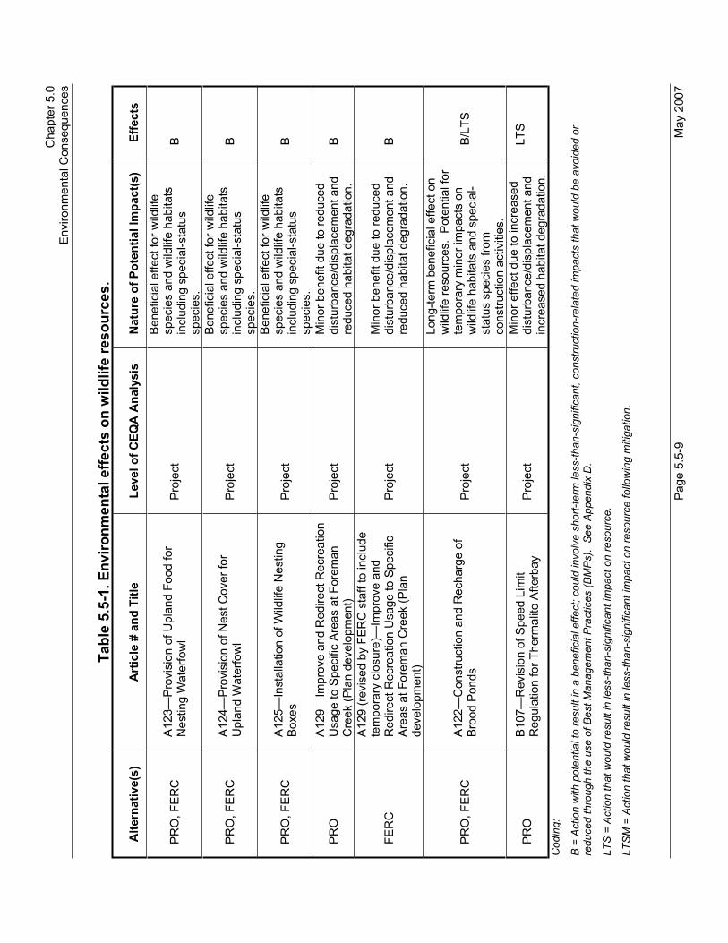
C
hapt
er 5
.0
E
nviro
nmen
tal C
onse
quen
ces
P
age
5.5-
9 M
ay 2
007
Tabl
e 5.
5-1.
Env
ironm
enta
l effe
cts
on w
ildlif
e re
sour
ces.
Alte
rnat
ive(
s)
Art
icle
# a
nd T
itle
Leve
l of C
EQA
Ana
lysi
s N
atur
e of
Pot
entia
l Im
pact
(s)
Effe
cts
PR
O, F
ER
C
A12
3—P
rovi
sion
of U
plan
d Fo
od fo
r N
estin
g W
ater
fow
l P
roje
ct
Ben
efic
ial e
ffect
for w
ildlif
e sp
ecie
s an
d w
ildlif
e ha
bita
ts
incl
udin
g sp
ecia
l-sta
tus
spec
ies.
B
PR
O, F
ER
C
A12
4—P
rovi
sion
of N
est C
over
for
Upl
and
Wat
erfo
wl
Pro
ject
Ben
efic
ial e
ffect
for w
ildlif
e sp
ecie
s an
d w
ildlif
e ha
bita
ts
incl
udin
g sp
ecia
l-sta
tus
spec
ies.
B
PR
O, F
ER
C
A12
5—In
stal
latio
n of
Wild
life
Nes
ting
Box
es
Pro
ject
Ben
efic
ial e
ffect
for w
ildlif
e sp
ecie
s an
d w
ildlif
e ha
bita
ts
incl
udin
g sp
ecia
l-sta
tus
spec
ies.
B
PR
OA
129—
Impr
ove
and
Red
irect
Rec
reat
ion
Usa
ge to
Spe
cific
Are
as a
t For
eman
C
reek
(Pla
n de
velo
pmen
t) P
roje
ct
Min
or b
enef
it du
e to
redu
ced
dist
urba
nce/
disp
lace
men
t and
re
duce
d ha
bita
t deg
rada
tion.
B
FER
C
A12
9 (r
evis
ed b
y FE
RC
sta
ff to
incl
ude
tem
pora
ry c
losu
re)—
Impr
ove
and
Red
irect
Rec
reat
ion
Usa
ge to
Spe
cific
A
reas
at F
orem
an C
reek
(Pla
n de
velo
pmen
t)
Pro
ject
M
inor
ben
efit
due
to re
duce
d di
stur
banc
e/di
spla
cem
ent a
nd
redu
ced
habi
tat d
egra
datio
n.
B
PR
O, F
ER
C
A12
2—C
onst
ruct
ion
and
Rec
harg
e of
B
rood
Pon
ds
Pro
ject
Long
-term
ben
efic
ial e
ffect
on
wild
life
reso
urce
s. P
oten
tial f
or
tem
pora
ry m
inor
impa
cts
on
wild
life
habi
tats
and
spe
cial
-st
atus
spe
cies
from
co
nstru
ctio
n ac
tiviti
es.
B/LT
S
PR
OB
107—
Rev
isio
n of
Spe
ed L
imit
Reg
ulat
ion
for T
herm
alito
Afte
rbay
P
roje
ct
Min
or e
ffect
due
to in
crea
sed
dist
urba
nce/
disp
lace
men
t and
in
crea
sed
habi
tat d
egra
datio
n.
LTS
Cod
ing:
B =
Act
ion
with
pot
entia
l to
resu
lt in
a b
enef
icia
l effe
ct; c
ould
invo
lve
shor
t-ter
m le
ss-th
an-s
igni
fican
t, co
nstru
ctio
n-re
late
d im
pact
s th
at w
ould
be
avoi
ded
or
redu
ced
thro
ugh
the
use
of B
est M
anag
emen
t Pra
ctic
es (B
MP
s).
See
App
endi
x D
.
LTS
= A
ctio
n th
at w
ould
resu
lt in
less
-than
-sig
nific
ant i
mpa
ct o
n re
sour
ce.
LTS
M =
Act
ion
that
wou
ld re
sult
in le
ss-th
an-s
igni
fican
t im
pact
on
reso
urce
follo
win
g m
itiga
tion.

Draft Environmental Impact Report Oroville Facilities Relicensing—FERC Project No. 2100
May 2007 Page 5.5-10
Program-Level Impacts and Mitigation Measures
Impact 5.5.4.1-a: Have a substantial adverse effect, either directly or through habitat modifications, on any species identified as a candidate, sensitive, or special-status species in local or regional plans, policies, or regulations, or by DFG or USFWS.
NO The Riverbend Park project, initiated by the Feather River Recreation and Park District (FRRPD) and partially funded by DWR as an Interim Project, was evaluated in a separate CEQA document (FRRPD 2003). No other interim recreation projects required CEQA documentation and were designed to avoid or minimize soil and vegetation disturbances and generally involved only minor modification of existing facilities within areas of previous disturbance. No significant wildlife habitat impacts occurred due to implementation of other interim recreation projects.
Potential ongoing project effects on nesting bank swallows were mitigated in consultation with DFG through habitat protection on the lower Feather River. DWR acquired a conservation easement that allows a geomorphically active portion of the river to continue to erode and provide high-quality bank swallow nesting habitat.
Endangered Species Act (ESA) conservation measures associated with informal consultation for the Terrestrial BA and that were implemented early were designed in consultation with USFWS to avoid and minimize selected ongoing impacts on nesting bald eagles and vernal pool habitats. None of the actions associated with these conservation measures would result in loss or degradation of wildlife habitat. Additionally, conservation measures designed to protect nesting bald eagle habitat would also protect valley/foothill riparian habitat, blue oak/foothill pine, and montane conifer habitats from habitat manipulation or recreational development impacts. Likewise, conservation measures designed to protect vernal pool habitats serve to protect annual grassland and wetland habitats from loss and degradation associated with off-highway vehicle (OHV) damage. The habitat impacts associated with implementation of these conservation measures are beneficial.
Several of the interim recreation projects involved actions adjacent to federally listed wildlife species habitats, including vernal pool invertebrate habitat and valley elderberry longhorn beetle habitat.USFWS-prescribed buffers were incorporated into the interim recreation projects design to avoid impacts, including a 100-foot buffer around elderberry shrubs and 200-foot buffer around vernal

Chapter 5.0 Environmental Impacts
Page 5.5-11 May 2007
pools.
PRO, FERC The majority of the remaining programs included within the Proposed Project involve at least minor modification, degradation, or loss of existing wildlife habitat. Actions expected to result in less than 1 acre of direct habitat loss include activities described under SA Articles A104 and A105, and selected elements in Article A127. Individually, none of these projects represent a significant wildlife habitat loss; however, total loss of wildlife habitat from these programs associated with the combined implementation area of these actions could be a potentially significant impact on wildlife habitat.
No program-level actions included within the Proposed Project have the potential to affect greater sandhill crane, bank swallow, peregrine falcon, or yellow-billed cuckoo. However, staging areas and river access improvements required for The Gravel Supplementation and Improvement Program could have a potentially significant impact on Swainson’s hawk and bald eagle nesting habitats as well as giant garter snake habitat.
Several programmatic actions included within this alternative are designed to protect State-listed species/habitats or will incidentally result in a beneficial effect on these species. These actions include activities described under SA Articles A110 and A111.
Programmatic actions that have at least some potential to adversely affect State-listed species or their habitats are SA Articles A102, A103, A104, A105, and A127. These programs have the potential to significantly impact bald eagles, Swainson’s hawks, and giant garter snake habitat.
Programmatic actions that could occur within or adjacent to giant garter snake habitat with the potential to adversely affect this species include activities described under SA Articles A102, A103, A104, A105, A122, A123, A124, trails, ADA improvements, upgrades, or new day use areas (DUAs) (including watchable wildlife sites), upgrades to boat ramps, and installation of a new sandy beach. These actions could result in potentially significant impacts.
Implementation of SA Articles A102, A103, A104, and A105 may have the potential for minor impacts on wildlife resources, including special-status species, which may include nesting bald eagles, valley elderberry longhorn beetles, giant garter snakes, and California red-legged frogs, and their associated habitats from construction activities. However, early implementation of the Draft

Draft Environmental Impact Report Oroville Facilities Relicensing—FERC Project No. 2100
May 2007 Page 5.5-12
Terrestrial BA and implementation of conditions contained in the Final Terrestrial BO would result in less-than-significant impacts on special-status species.
Staging areas and river access improvements required for the Gravel Supplementation and Improvement Program could impact valley elderberry longhorn beetle, giant garter snake habitat, and bald eagle nesting habitat. These projects would be designed or constructed to avoid significant habitat degradation for federally listed threatened or endangered wildlife species consistent with the Final Terrestrial BO and would result in less-than-significantimpacts.
During implementation of Feather River fisheries enhancements, DWR would abide by USFWS BO terms and conditions designed to avoid impacts to listed species including bald eagle, valley elderberry longhorn beetle, and giant garter snake. These terms and conditions would reduce impacts to less-than-significant.
As described in the SA RMP, the Potter Ravine trail extends an existing trail an additional 2.2 miles and ends immediately outside the secondary protection zone for a bald eagle nest territory. The existing Potter’s Ravine trail is subject to administrative closure from January 1 through August 31 during years that a nearby bald eagle nest territory is active. With continued seasonal closures, extension of the trail as described in SA Article A127 would result in less-than-significant impacts on nesting eagles. Termination of the trail before entering the protection zone would avoid impacts on nesting bald eagles in compliance with the Bald Eagle Nest Territory Management Plan and no mitigation would be required.
Wildlife habitat enhancements and recreational developments at the Thermalito Complex can be designed and implemented to avoid and buffer vernal pool invertebrate habitat, which would reduce any impacts to less-than-significant. No mitigation would be required.
Giant garter snake habitat losses may be associated with North Forebay fishing access improvements and the creation of a sandy beach at Larkin Road. These habitat losses can be minimized through project design and construction. These projects would be designed or constructed to avoid significant habitat degradation for federally listed threatened or endangered wildlife species consistent with the Final Terrestrial BO and would result in less-than-significant impacts.

Chapter 5.0 Environmental Impacts
Page 5.5-13 May 2007
Mitigation measure 5.5.4.1-a: Have a substantial adverse effect, either directly or through habitat modifications, on any species identified as a candidate, sensitive, or special-status species in local or regional plans, policies, or regulations, or by DFG or USFWS.
PRO, FERC The following actions can be implemented to reduce the impact as a result of habitat losses under the Proposed Project.
Minimize direct habitat loss or disturbance through project design and construction timing. Retain screening vegetation to limit indirect habitat loss and wildlife disruption/displacement. Retain key wildlife habitat elements to the extent possible including snags, woody dead and down material, live trees containing cavities, and shrub cover. Retain mature trees and minimize use of non-native landscaping. Minimize recreational development in riparian or wetland habitats. Revegetate areas of disturbed soil.Implementation of these mitigation and avoidance measures would reduce direct habitat loss and reduce potential impacts toless-than-significant.
Spatial and/or temporal avoidance of species identified as a candidate, sensitive, or special-status species by DFG or USFWS would reduce the impact to a less-than-significant level.
Impact 5.5.4.1-b: Interfere substantially with the movement of any native resident or migratory wildlife species or with established native resident or migratory wildlife corridors, or impede the use of native wildlife nursery sites.
NO None of the interim recreation projects or conservation measures associated with informal consultation for the Terrestrial BA, and that were implemented early prior to new license issuance, have the potential to create barriers to wildlife dispersal or movement. No impact is anticipated.
PRO, FERC The Fish Weir Program (SA Article A105) has the potential to create a barrier to wildlife dispersal and movement. The Fish Weir Program may impede upstream movement of the highly aquatic western pond turtle, a State Species of Special Concern. This passage issue is a potentially significant impact.
Mitigation measure 5.5.4.1-b: Interfere substantially with the movement of any native resident or migratory wildlife species or with established native resident or migratory wildlife corridors, or impede the use of native wildlife nursery sites.
PRO, FERC Modify weir design and operation to allow turtles passage without allowing salmon passage. Allow shoreline/shallow-water passage during periods of stable flow. Implementation of these mitigation

Draft Environmental Impact Report Oroville Facilities Relicensing—FERC Project No. 2100
May 2007 Page 5.5-14
and avoidance measures would reduce direct habitat loss and reduce potential impacts to a less-than-significant level.
Impact 5.5.4.1-c: Directly Disturb or Create Long-Term Effects on Wildlife Population Dynamics and Cause a Substantial Reduction in Wildlife Use of Established Habitats Within the Project Area.
NO None of the interim recreation projects or conservation measures associated with informal consultation for the Draft Terrestrial BA and that were implemented early, prior to new license issuance, have the potential to substantially reduce wildlife habitat use or negatively affect long-term wildlife population dynamics. Nosignificant impact is anticipated.
PRO, FERC Several programmatic actions within the Proposed Project are designed to benefit specific wildlife species or groups of species.These actions will benefit individual animals but are probably insignificant at the population level. Examples of these beneficialactions include activities described under SA Articles A110 (Lake Oroville Warm Water Fishery Habitat Improvement Program) and A111 (Lake Oroville Cold Water Fishery Habitat Improvement Program).
The Gravel Supplementation and Improvement Program (SA Article A102) could provide more productive wildlife habitats. If gravel is sourced from barren gravel tailings, then additional wildlife habitat values could be created at these sites. Installation of additional vehicular barriers within the Oroville Wildlife Area (OWA) could serve to reduce habitat degradation and vehicle-related mortality of sedentary wildlife and reduce wildlife disturbance or displacement. Restrictions on motorized wheeled vehicle use within the drawdown zone of Lake Oroville could serve to reduce disturbance or displacement of both lacustrine and terrestrial wildlife species. These actions would result in less-than-significant effects for wildlife therefore no mitigation is necessary.
Mitigation measure 5.5.4.1-c: No mitigation is required.
Impact 5.5.4.1-d: Substantially Conflict with Any Local Policies, Ordinances, Adopted HCPs, NCCPs, or Other Approved Plans Protecting Wildlife Resources Within the Project Boundary.
NO None of the actions in the No-Project Alternative, including interim recreation projects or conservation measures associated with informal consultation for the Draft Terrestrial BA and that were implemented early, have the potential to substantially conflict with

Chapter 5.0 Environmental Impacts
Page 5.5-15 May 2007
any local policies, ordinances, adopted HCPs, NCCPs, or other approved plans protecting wildlife resources within the project boundary. No impact is anticipated.
PRO, FERC None of the actions in the Proposed Project have the potential to substantially conflict with any local policies, ordinances, adopted HCPs, NCCPs, or other approved plans protecting wildlife resources within the project boundary. No impact therefore no mitigation is necessary.
Mitigation measure: 5.5.4.1-d: No mitigation is required.
Impact 5.5.4.1-e: Have a substantial adverse effect on any riparian habitat or other sensitive natural community identified in local or regional plans, policies, regulations, or by the DFG or USFWS.
NO None of the interim recreation projects or conservation measures associated with informal consultation for the Draft Terrestrial BA and that were implemented early has the potential to substantially impede the use of wildlife nursery areas.
PRO, FERC Programmatic actions where specific project locations are not currently known have the potential to significantly affect wildlife nursery areas. The Gravel Supplementation and Improvement Program (SA Article A102) has the potential to result in short-term,potentially significant impacts on heron/egret rookeries through direct habitat loss and disturbance associated with construction access, staging, and in-water construction.
Over the long term, the Gravel Supplementation and Improvement Program (SA Article A102) and the Riparian and Floodplain Improvement Program (SA Article A106) could provide more productive wildlife habitats. If gravel is sourced from barren gravel tailings, then additional wildlife habitat values could be created at these sites. Installation of additional vehicular barriers within the OWA could serve to reduce vehicle-related mortality of sedentary wildlife and reduce wildlife disturbance or displacement.Restrictions on motorized wheeled vehicle use within the drawdown zone of Lake Oroville could serve to reduce disturbance or displacement of both lacustrine and terrestrial wildlife species. These actions would result in less-than-significant impacts.
Actions to enhance Feather River fisheries habitats through SA Articles A103, A104, and A105 would have a less-than-significant effect on rookeries with implementation of Best Management Practices (BMPs) implemented as part of either the Proposed Project or the FERC Staff Alternative.

Draft Environmental Impact Report Oroville Facilities Relicensing—FERC Project No. 2100
May 2007 Page 5.5-16
Mitigation measure 5.5.4.1-e: Have a substantial adverse effect on any riparian habitat or other sensitive natural community identified in local or regional plans, policies, regulations, or by the DFG or USFWS.
PRO, FERC During construction activities, avoid wildlife nursery areas during critical nesting periods. Implementation of this mitigation measure would reduce the impact to less-than-significant.
Impact 5.5.4.1-f: Substantial Habitat Degradation for Wildlife Species Identified by USFWS as Threatened or Endangered Species.
NO Several of the interim recreation projects involved actions adjacent to federally listed wildlife species habitats, including vernal pool invertebrate habitat and valley elderberry longhorn beetle habitat.USFWS-prescribed buffers were incorporated into the interim recreation projects design to avoid impacts, including a 100-foot buffer around elderberry shrubs and 200-foot buffer around vernal pools.
Conservation measures associated with informal consultation for the Draft Terrestrial BA and that were implemented early, prior to issuance of the new license, were designed in consultation with USFWS to avoid potential ongoing impacts on both nesting bald eagle habitat and vernal pool invertebrate habitat.
Riverbend Park improvements generally avoided impacts on federally listed wildlife species through facilities siting and project design (FRRPD 2003). Loss of any USFWS threatened or endangered species was addressed in a separate EIR (FRRPD 2003) and Biological Opinion (BO) (USACE, 2004).
PRO, FERC Implementation of SA Articles A102, A103, A104, and A105 may have the potential for minor impacts on wildlife resources, including special-status species, which may include nesting bald eagles, valley elderberry longhorn beetles, giant garter snakes, and California red-legged frogs, and their associated habitats from construction activities. However, early implementation of the Draft Terrestrial BA and implementation of conditions contained in the Final Terrestrial BO would result in less-than-significant impacts on special-status species.
Staging areas and river access improvements required for the Gravel Supplementation and Improvement Program could impact valley elderberry longhorn beetle, giant garter snake habitat, and bald eagle nesting habitat. These projects would be designed or constructed to avoid significant habitat degradation for federally listed threatened or endangered wildlife species consistent with

Chapter 5.0 Environmental Impacts
Page 5.5-17 May 2007
the Final Terrestrial BO and would result in less-than-significantimpacts. No mitigation would be required.
During implementation of Feather River fisheries enhancements, DWR would abide by USFWS BO terms and conditions designed to avoid impacts to listed species including bald eagle, valley elderberry longhorn beetle, and giant garter snake. These terms and conditions would reduce impacts to less-than-significant.
As described in the SA RMP, the Potter Ravine trail extends an existing trail an additional 2.2 miles and ends immediately outside the secondary protection zone for a bald eagle nest territory. The existing Potter’s Ravine trail is subject to administrative closure from January 1 through August 31 during years that a nearby bald eagle nest territory is active. With continued seasonal closures, extension of the trail as described in SA Article A127 would result in less-than-significant impacts on nesting eagles. Termination of the trail before entering the protection zone would avoid impacts on nesting bald eagles in compliance with the Bald Eagle Nest Territory Management Plan and no mitigation would be required.
Wildlife habitat enhancements and recreational developments at the Thermalito Complex can be designed and implemented to avoid and buffer vernal pool invertebrate habitat, which would reduce any impacts to less-than-significant. No mitigation would be required.
Giant garter snake habitat losses may be associated with North Forebay fishing access improvements and the creation of a sandy beach at Larkin Road. These habitat losses can be minimized through project design and construction. These projects would be designed or constructed to avoid significant habitat degradation for federally listed threatened or endangered wildlife species consistent with the Final Terrestrial BO and would result in less-than-significant impacts.
Mitigation measure 5.5.4.1-f: No mitigation is required.
Impact 5.5.4.1-g: Result in a Substantial Impact on a Wildlife Species that is Listed by DFG or USFWS as a Candidate, Sensitive, or Special-Status Species, or on its Designated Habitat.
NO The interim recreation projects or conservation measures associated with informal consultation for the Draft Terrestrial BA that were implemented early would have no impact on candidate, sensitive, or special-status species/habitat.
Potential impacts from the Riverbend Park recreational

Draft Environmental Impact Report Oroville Facilities Relicensing—FERC Project No. 2100
May 2007 Page 5.5-18
development were addressed under a separate EIR (FRRPD 2003); these actions resulted in less-than-significant impacts.
PRO, FERC Actions specifically designed in consultation with USFWS to protect and enhance federally listed species habitats will also provide benefits to a variety of special-status species. Wildlife and fisheries habitat enhancement actions such as brood pond construction/recharge, Lake Oroville warm and coldwater fisheries enhancements, and waterfowl nest cover and forage enhancements will also benefit special-status species. Special-status species that could potentially benefit from these actions include American bittern, American white pelican, Bell’s sage sparrow, black tern, black-crowned night heron, California gull, California thrasher, Cooper’s hawk, double-crested cormorant, long-eared owl, merlin, northern harrier, osprey, short-eared owl, tricolored blackbird, western burrowing owl, least bittern, yellow warbler, white-tailed kite, yellow-breasted chat, and western pond turtle.
However, some programs or actions have the potential to affect one or more special-status wildlife species. Feather River fisheries enhancement actions (activities described under SA Articles A102, A103, A104, and A105) would result in short-term habitat loss degradation to several special-status riverside species including river otter, pond turtle, double-crested cormorant, American white pelican, black tern, California gull, and osprey. No substantial long-term effects on these species are predicted and these actions would have less-than-significant impacts.
The Gravel Supplementation and Improvement Program has the potential to result in short-term adverse impacts on riparian and riverine habitats and species associated with these habitats through direct habitat loss and disturbance associated with construction access, staging, and in-water construction. These species could include American bittern, American white pelican, Barrow’s goldeneye, black tern, California gull, California thrasher, Cooper’s hawk, double-crested cormorant, osprey, yellow warbler, yellow-breasted chat, western pond turtle, and river otter. However, over the long term, and with implementation of included BMPs, these effects would be less-than-significant and no mitigation would be required.
The Fish Weir Program has the potential to result in a substantial impact on western pond turtle by impairing upstream movement as discussed in Section 5.5.4.1-b above. This could result in a significant impact.
Chapter 5.0 Environmental Impacts
Page 5.5-19 May 2007
Mitigation measure 5.5.4.1-g: Result in a Substantial Impact on a Wildlife Species that is Listed by DFG or USFWS as a Candidate, Sensitive, or Special-Status Species, or on its Designated Habitat.
PRO, FERC Modify weir design to allow turtle passage. Allow shoreline/shallow water passage during periods of stable flow.Implementation of this mitigation measure would reduce the impact to turtle passage to less-than-significant levels.
Project-Level Impacts and Mitigation Measures
Impact 5.5.4.1-a: Have a substantial adverse effect, either directly or through habitat modifications, on any species identified as a candidate, sensitive, or special-status species in local or regional plans, policies, or regulations, or by DFG or USFWS.
NO The Riverbend Park project, initiated as an interim recreation project, was evaluated in a separate CEQA document (FRRPD 2003). Other interim recreational improvements were screened to avoid the need for CEQA documentation and were designed to avoid or minimize soil and vegetation disturbances and generally involved only minor modification of existing facilities within areas of previous disturbance. No significant wildlife habitat impacts occurred due to implementation of other interim recreation projects.
ESA conservation measures associated with informal consultation for the Terrestrial BA, and which were implemented early, were designed in consultation with USFWS to avoid and minimize selected ongoing impacts on nesting bald eagles and vernal pool habitats. None of the actions associated with these conservation measures would result in loss or degradation of wildlife habitat. Additionally, conservation measures designed to protect nesting bald eagle habitat would also protect valley/foothill riparian habitat, blue oak/foothill pine, and montane conifer habitats from habitat manipulation or recreational development impacts. Likewise, conservation measures designed to protect vernal pool habitats serve to protect annual grassland and wetland habitats from loss and degradation associated with OHV damage. The habitat impacts associated with implementation of these conservation measures are beneficial and have a less-than-significant impact.
PRO, FERC Several of the project-level actions included in the Proposed Project are designed to protect existing fish or wildlife habitats.These habitat protection actions described in the Terrestrial BA (DWR 2003) include 36 conservation measures developed in consultation with USFWS to protect/preserve habitat for species protected under ESA and generally reserve these lands from

Draft Environmental Impact Report Oroville Facilities Relicensing—FERC Project No. 2100
May 2007 Page 5.5-20
development or disturbance. These protection measures include conservation measures related to nesting bald eagle, giant garter snake, California red-legged frog, valley elderberry longhorn beetle, and vernal pool tadpole and fairy shrimp. Descriptions of these conservation measures are included in the Terrestrial BA (DWR 2003). While these conservation measures are designed to protect ESA-listed species habitats, they also serve to protect co-occurring wildlife species dependent upon mature coniferous forest, blue oak/foothill pine, freshwater emergent wetlands, riparian, annual grassland, and vernal pool habitats. Actions designed to protect/enhance wildlife habitats include activities described under SA Articles A117, A118, A119, A120, A121, A123, A124, and A125. These actions are designed to have beneficial effects on wildlife habitat.
Actions within the Proposed Project described in the Recreation Management Plan (RMP), SA Article A127, are estimated to involve habitat losses of 1 acre or more and would be apotentially significant impact on wildlife habitat. These actions, as described in SA Article A127, may include building of campgrounds, replacements, upgrades and/or new day-use areas, trail improvements, or new parking areas. However, with implementation of BMPs included as part of both the Proposed Project and the FERC Staff Alternative the impacts would be less-than-significant.
Mitigation measure 5.5.4.1-a: No mitigation is required.
Impact 5.5.4.1-b: Interfere substantially with the movement of any native resident or migratory wildlife species or with established native resident or migratory wildlife corridors, or impede the use of native wildlife nursery sites.
NO None of the interim recreation projects or conservation measures associated with informal consultation for the Terrestrial BA, and that were implemented early prior to new license issuance, have the potential to create barriers to wildlife dispersal or movement. No significant impact is anticipated.
None of the interim recreation projects or conservation measures associated with informal consultation for the Draft Terrestrial BA and that were implemented early have the potential to substantially impede the use of wildlife nursery areas. No impactis anticipated.

Chapter 5.0 Environmental Impacts
Page 5.5-21 May 2007
PRO, FERC The Fish Weir Program (SA Article A105) has the potential to create a barrier to wildlife dispersal and movement. The fish weir program may impede upstream movement of the highly aquatic western pond turtle, a State Species of Special Concern. This passage issue is a potentially significant impact.
Projects such as new construction at Lime Saddle, additional campsites, and new marina parking as described in SA Article A127, could significantly affect a rookery located near the boat ramp access road. These actions could result in adverse impacts on wildlife however, with implementation of BMPs included as part of both the Proposed Project and the FERC Staff Alternative the impacts would be less-than-significant.
The Gravel Supplementation and Improvement Program has the potential to result in short-term impacts; however, these impacts are less-than-significant to heron/egret rookeries through direct habitat loss and disturbance associated with construction access, staging, and in-water construction and no mitigation is necessary.
Mitigation measure 5.5.4.1-b: Interfere substantially with the movement of any native resident or migratory wildlife species or with established native resident or migratory wildlife corridors, or impede the use of native wildlife nursery sites.
PRO, FERC The weir would be designed to allow turtles passage without allowing salmon passage and allow shoreline/shallow water passage during periods of stable flow. Modification of operation and design of the fish weir would reduce this impact to less-than-significant.
Impact 5.5.4.1-c: Directly Disturb or Create Long-Term Effects on Wildlife Population Dynamics and Cause a Substantial Reduction in Wildlife Use of Established Habitats within the Project Area.
NO None of the interim recreation projects or conservation measures associated with informal consultation for the Terrestrial BA and that were implemented early, prior to new license issuance, have the potential to substantially reduce wildlife habitat use or negatively affect long-term wildlife population dynamics. Noimpact.
PRO, FERC SA Article A127 may affect wildlife species through the development of trails or major new recreational developments.Wildlife species may be adversely affected by indirect habitat loss associated with disturbance or displacement resulting from short-term construction-related activities or long-term increases in

Draft Environmental Impact Report Oroville Facilities Relicensing—FERC Project No. 2100
May 2007 Page 5.5-22
recreational use. Actions with the potential to result in either short-term reduction in wildlife use due to increased human disturbance include construction-related activities. Long-term increases in wildlife disturbance/displacement are likely to be associated with those measures that serve to increase recreational use, extend the period of recreational use, or expand the area of recreational use. These potential indirect effects are less-than-significantimpacts.
Several project-level actions within the Proposed Project are designed to benefit specific wildlife species or groups of species.These actions will benefit individual animals but are probably insignificant at the population level. Examples of these beneficialactions include activities described under SA Articles A117, A118, A119, A120, A121, A122, A123, A124, and A125.
Thirty-six conservation measures were developed in consultation with USFWS for the protection of federally listed species. Cumulatively, these measures place severe restrictions on future habitat disturbance on over 8,000 acres within the project area and preserve riparian, annual grassland (including vernal pools), freshwater emergent wetland, blue oak/foothill pine, and mature coniferous forest habitats. Wildlife habitat improvement measures (construction of waterfowl brood ponds, installation of wildlife boxes, recharge of waterfowl brood ponds, and waterfowl nest cover and forage enhancements) are designed to benefit selected wildlife species within portions of the project area. These species include waterfowl, small mammals, raptors, secondary cavity nesters, aquatic reptiles and amphibians, and ground nesting or seed/grain eating birds. Increased patrol and enforcement on project lands could reduce wildlife disturbance and losses associated with OHV use, illegal hunting, arson, illegal dumping of trash and hazardous materials, trespass, and violation of seasonal or area recreational closures. In addition to construction-related direct habitat loss, native wildlife species could be affected in other ways by implementation of the Proposed Project, including increased recreational or construction-related disturbance/displacement, improved habitat conditions for non-native competitors, and construction-related wildlife mortality as well as increases in traffic-related wildlife mortality during operations. These impacts are short-term and less-than-significant.
Modification of the Thermalito Afterbay speed limit (SA Section B107) to allow boat speeds greater than 5 mph would appear to result in increased disturbance displacement of wildlife, including migratory waterfowl, in the portion of the Afterbay south of State

Chapter 5.0 Environmental Impacts
Page 5.5-23 May 2007
Route 162. However, as a practical matter the 5-mph speed limit has never been enforced, so enforcement provided through actions under SA Section B111 may serve to reduce boating related wildlife disturbance and/or displacement in the future over historic levels; therefore, the effects of Section B111 are less-than-significant.
Mitigation measure 5.5.4.1-c: No mitigation is required.
Impact 5.5.4.1-f: Substantial Habitat Degradation for Wildlife Species Identified by DFG as Threatened or Endangered Species.
NO None of the interim recreation projects or conservation measures associated with informal consultation for the Draft Terrestrial BA, and that were implemented early prior to issuance of the new license, involved actions within or adjacent to State-listed wildlife species habitats. Likewise, Riverbend Park improvements avoided impacts on State-listed species habitats. Potential ongoing project effects on nesting bank swallows are being mitigated in consultation with DFG through habitat protection on the lower Feather River. DWR is acquiring a conservation easement, which allows a geomorphically active portion of the river to continue to erode and provide high-quality bank swallow nesting habitat.
No take of any State Fully Protected Species would occur as defined in the Fish and Game Code.
PRO, FERC No project-level actions included within the Proposed Project have the potential to affect greater sandhill crane, bank swallow, peregrine falcon, or yellow-billed cuckoo. However, staging areas and river access improvements required for the Gravel Supplementation and Improvement Program could have potentially significant impacts on Swainson’s hawk and bald eagle nesting habitats as well as giant garter snake habitat. Projects in this program would be designed or constructed to avoid significant habitat degradation for State protected species and would result in less-than-significant impacts. In addition, implementation of BMPs included in both the Proposed Project and the FERC Staff Alternative would reduce these to less-than-significant levels and no additional mitigation is necessary.
No take of any State Fully Protected Species would occur as defined in the Fish and Game Code.
Several project actions included within these alternatives are designed to protect State-listed species/habitats or will incidentally result in a beneficial effect on these species. These actions include activities described under SA Articles A117, A118, A119,

Draft Environmental Impact Report Oroville Facilities Relicensing—FERC Project No. 2100
May 2007 Page 5.5-24
A120, A121, A122, A123, and A124.
Mitigation measure 5.5.4.1-f: No mitigation is required.
Impact 5.5.4.1-f: Substantial Habitat Degradation for Wildlife Species Identified by USFWS as Threatened or Endangered Species.
NO Several of the interim recreation projects involved actions adjacent to federally listed wildlife species habitats including vernal pool invertebrate habitat and valley elderberry longhorn beetle habitat.USFWS-prescribed buffers were incorporated into the interim recreation projects design to avoid impacts including a 100-foot buffer around elderberry shrubs and 200-foot buffer around vernal pools.
Conservation measures associated with informal consultation for the Draft Terrestrial BA and that were implemented early, prior to issuance of the new license, were designed in consultation with USFWS to avoid potential ongoing impacts on both nesting bald eagle habitat and vernal pool invertebrate habitat.
Riverbend Park improvements generally avoided impacts on federally listed wildlife species through facilities siting and project design (FRRPD 2003). Loss of any USFWS threatened or endangered species were addressed in a separate EIR and BO.
PRO, FERC Several of the Proposed Project project-level actions included within this alternative were developed in consultation with USFWS specifically to protect or enhance habitats for federally listed wildlife species. These conservation measures include activities described under SA Articles A117, A118, A119, A120, A121, A122, A123, and A124. Implementation of these articles would result in a beneficial effect for wildlife species and wildlife habitats including special-status species.
Staging areas and river access improvements required for the Gravel Supplementation and Improvement Program could impact valley elderberry longhorn beetle, giant garter snake habitat, and bald eagle nesting habitat. These projects would be designed or constructed to avoid significant habitat degradation for federally listed threatened or endangered wildlife species consistent with the Final Terrestrial BO and would result in less-than-significantimpacts. No additional mitigation would be necessary.
The existing Potter’s Ravine trail is subject to administrative closure by DPR from January 1 through August 31 during years that the bald eagle nest territory is active. Extension of the trail as described in SA Article A127 would result in less-than-significant
Chapter 5.0 Environmental Impacts
Page 5.5-25 May 2007
impacts on nesting eagles if seasonal closures continue to be implemented and the trail terminates outside of the bald eagle nest territory protection zone.
Recreational developments, such as trails, at the Thermalito Complex would be designed and implemented to avoid and buffer vernal pool invertebrate habitat consistent with the Final terrestrial BO, which would reduce any impacts to less-than-significant.Potential impacts on valley elderberry longhorn beetle habitat would be minimized through the incorporation of avoidance into project design of recreational improvement projects consistent with the Final Terrestrial BO, which would reduce any impacts to less-than-significant.
Potential impacts on giant garter snake habitat would be minimized and reduced to less-than-significant through incorporation of avoidance measures consistent with the Final Terrestrial BO and BMPs described in Appendix D for recreational improvement projects.
Giant garter snake habitat losses may be associated with North Forebay fishing access improvements and the creation of a sandy beach at Larkin Road. These habitat losses can be minimized through project design and construction consistent with the Final Terrestrial BO to minimize the effects to less-than-significant.
Mitigation measure 5.5.4.1-f: No mitigation is required.
Impact 5.5.4.1-g: Result in a Substantial Impact on a Wildlife Species that is Listed by DFG or USFWS as a Candidate, Sensitive, or Special-Status Species, or on its Designated Habitat.
NO The interim recreation projects or conservation measures associated with informal consultation for the Draft Terrestrial BA that were implemented early would have no impacts on candidate, sensitive, or special-status species/habitat.
Potential impacts from the Riverbend Park recreational development were addressed under a separate EIR; these actions resulted in less-than-significant impacts (FRRPD 2003).

Draft Environmental Impact Report Oroville Facilities Relicensing—FERC Project No. 2100
May 2007 Page 5.5-26
PRO, FERC Actions specifically designed in consultation with USFWS to protect and enhance federally listed species habitats will also provide benefits to a variety of special-status species. Wildlife and fisheries habitat enhancement actions such as brood pond construction/recharge, Lake Oroville warm and coldwater fisheries enhancements, and waterfowl nest cover and forage enhancements will also benefit special-status species. Special-status species that could potentially benefit from these actions include American bittern, American white pelican, Bell’s sage sparrow, black tern, black-crowned night heron, California gull, California thrasher, Cooper’s hawk, double-crested cormorant, long-eared owl, merlin, northern harrier, osprey, short-eared owl, tricolored blackbird, western burrowing owl, least bittern, yellow warbler, white-tailed kite, yellow-breasted chat, and western pond turtle.
The Gravel Supplementation and Improvement Program has the potential to result in short-term impacts on riparian and riverine habitats and species associated with these habitats through direct habitat loss and disturbance associated with construction access, staging, and in-water construction. These species could include American bittern, American white pelican, Barrow’s goldeneye, black tern, California gull, California thrasher, Cooper’s hawk, double-crested cormorant, osprey, yellow warbler, yellow-breasted chat, western pond turtle, and river otter. With implementation of the BMPs described in Appendix D, these effects are not expected to result in long-term impacts and would be less-than-significant.
Recreational developments including trail, road, campground, boat ramp, DUA, and parking lot construction would result in potential short-term impacts on forest and grassland special-status species through disturbance displacement. The effects are not expected to result in substantial long-term impacts on certain special-status wildlife species and would result in less-than-significant impacts on these species. No mitigation would be required.
Mitigation measure: 5.5.4.1-g: No mitigation is required.
Impact 5.5.4.1-h: Substantially Conflict with Any Local Policies, Ordinances, Adopted HCPs, NCCPs, or Other Approved Plans Protecting Wildlife Resources Within the Project Boundary.
NO, PRO, FERC None of the actions in the No-Project, Proposed Project, or FERC Staff Alternative, including interim recreation projects or conservation measures associated with informal consultation for the Draft Terrestrial BA and that were implemented early, have the potential to substantially conflict with any local policies,

Chapter 5.0 Environmental Impacts
Page 5.5-27 May 2007
ordinances, adopted HCPs, NCCPs, or other approved plans protecting wildlife resources within the project boundary. Noimpact is anticipated and therefore, no mitigation is required.
Mitigation measure 5.5.4.1-h: No mitigation is required.

Draft Environmental Impact Report Oroville Facilities Relicensing—FERC Project No. 2100
May 2007 Page 5.5-28
This page intentionally left blank.

Chapter 5.0 Environmental Impacts
Page 5.5-29 May 2007
5.5.4.2 Botanical Impacts and Mitigation Measures
This section describes the potential effects of the alternatives on terrestrial resources, including natural riparian habitat and other sensitive natural terrestrial communities, federally protected wetlands, special-status species and habitats, and non-native invasive species.
Under the No-Project Alternative, existing project operations, land management practices, and project-related recreation activities that may affect botanical resources include Lake Oroville water level fluctuations, Thermalito Complex operations, flow releases from Lake Oroville to both the Low Flow Channel (LFC) and High Flow Channel (HFC) of the Feather River, ground/soil disturbance from operations and maintenance activities, disturbance from project-related recreation including facilities maintenance and recreational use, and wildlife habitat and vegetation management. (See Section 4.5.2.1 for more detail on baseline effects on botanical resources.) The No-Project Alternative also includes a number of other actions that may affect botanical resources. These include Interim recreation projects that DWR agreed to implement prior to license issuance, including Riverbend Park recreational improvements and conservation measures that were developed in coordination with USFWS under the Section 7 ESA informal consultation process and discussed in detail in the draft Programmatic BA.
In addition to No-Project, this DEIR analyzes the Proposed Project and the FERC Staff Alternative. These alternatives include a number of plans and programs to enhance, protect, mitigate, restore, and/or create habitat within the project area as described in the SA. The SA proposes the development of two plans (Invasive Species Management Plan (Article A126) and Fuel Load Management Plan (Article B102)) that are expected to include measures that would be beneficial to terrestrial botanical resources. Development of these plans would not result in environmental effects on resources and therefore are not evaluated in this DEIR. Once developed, the plans would be subject to additional CEQA review. Potential impacts are identified as follows:NO (No-Project), PRO (Proposed Project), FERC (FERC Staff Alternative). All alternatives analyzed result in beneficial or less-than-significant impacts on botanical resources with implementation of mitigation.
Potential impacts on botanical resources are evaluated at a program level of analysis whenever the proposed actions do not have a sufficient level of detail regarding design, operational characteristics, location, implementation timing, or methods of implementation to adequately support a project level of analysis. As such, prior to their implementation, these actions would also be subject to subsequent environmental analysis and documentation when additional specificity of the actions becomes available and after they have undergone the Ecological Committee (EC) review and comment process as described in the SA. Where adequate level of detail is available to assess project impacts on botanical resources, project-level analyses were performed.

Dra
ft E
nviro
nmen
tal I
mpa
ct R
epor
t O
rovi
lle F
acilit
ies
Rel
icen
sing
—FE
RC
Pro
ject
No.
210
0
May
200
7 P
age
5.5-
30
Tabl
e 5.
5-2.
Env
ironm
enta
l effe
cts
on b
otan
ical
reso
urce
s.
Alte
rnat
ive(
s)
Art
icle
# a
nd T
itle
Leve
l of C
EQA
Ana
lysi
s N
atur
e of
Pot
entia
l Im
pact
(s)
Effe
cts
PR
O, F
ER
C
A10
2—G
rave
l Sup
plem
enta
tion
and
Impr
ovem
ent P
rogr
am
Pro
gram
mat
ic
Pot
entia
l for
min
or im
pact
s on
pl
ant c
omm
uniti
es, w
etla
nds,
se
nsiti
ve p
lant
spe
cies
hab
itats
, an
d pr
omot
ion
of in
vasi
ve
spec
ies
esta
blis
hmen
t fro
m
cons
truct
ion
activ
ities
.
B/LT
S/LT
SM
PR
O, F
ER
C
A10
3—C
hann
el Im
prov
emen
t Pro
gram
(T
his
actio
n is
pro
gram
mat
ic; h
owev
er,
Moe
’s a
nd H
atch
ery
Ditc
h ac
tiviti
es a
re
proj
ect-l
evel
)
Pro
gram
mat
ic w
ith s
ome
Pro
ject
ele
men
ts
Pot
entia
l for
min
or im
pact
s on
pl
ant c
omm
uniti
es, w
etla
nds,
se
nsiti
ve p
lant
spe
cies
hab
itats
, an
d pr
omot
ion
of in
vasi
ve
spec
ies
esta
blis
hmen
t fro
m
cons
truct
ion
activ
ities
.
B/LT
S/LT
SM
PR
O, F
ER
C
A10
4—S
truct
ural
Hab
itat
Sup
plem
enta
tion
and
Impr
ovem
ent
Pro
gram
Pro
gram
mat
ic
Pot
entia
l for
min
or im
pact
s on
pl
ant c
omm
uniti
es, w
etla
nds,
se
nsiti
ve p
lant
spe
cies
hab
itats
, an
d pr
omot
ion
of in
vasi
ve
spec
ies
esta
blis
hmen
t fro
m
cons
truct
ion
activ
ities
.
B/LT
S/LT
SM
PR
O, F
ER
C
A10
5—Fi
sh W
eir P
rogr
am
Pro
gram
mat
ic
Pot
entia
l for
min
or im
pact
s on
pl
ant c
omm
uniti
es, w
etla
nds,
se
nsiti
ve p
lant
spe
cies
/hab
itats
, an
d pr
omot
ion
of in
vasi
ve
spec
ies
esta
blis
hmen
t fro
m
cons
truct
ion
activ
ities
.
B/LT
S/LT
SM
PR
OA
106—
Rip
aria
n an
d Fl
oodp
lain
Im
prov
emen
t Pro
gram
P
rogr
amm
atic
Long
-term
ben
efic
ial e
ffect
on
bota
nica
l res
ourc
es.
Pot
entia
l fo
r tem
pora
ry m
inor
impa
cts
on
plan
t com
mun
ities
, wet
land
s,
and
sens
itive
pla
nt s
peci
es
habi
tats
from
con
stru
ctio
n ac
tiviti
es.
B/L
TSM
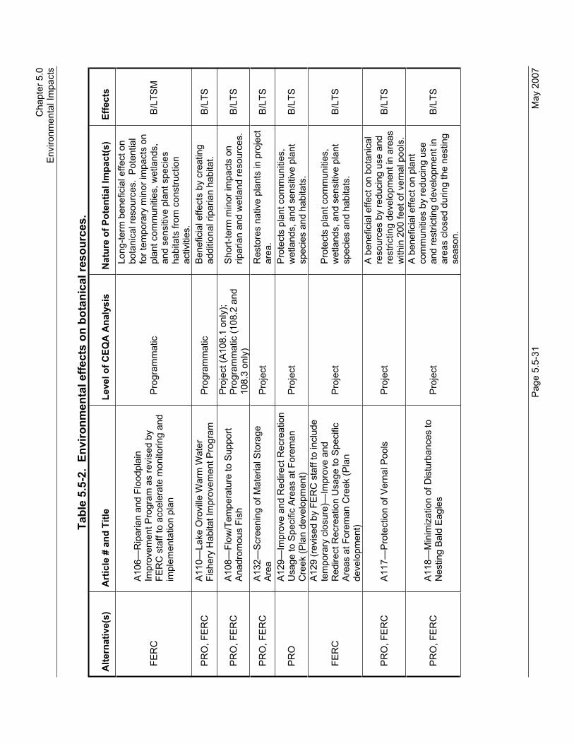
Cha
pter
5.0
Env
ironm
enta
l Im
pact
s
P
age
5.5-
31
May
200
7
Tabl
e 5.
5-2.
Env
ironm
enta
l effe
cts
on b
otan
ical
reso
urce
s.
Alte
rnat
ive(
s)
Art
icle
# a
nd T
itle
Leve
l of C
EQA
Ana
lysi
s N
atur
e of
Pot
entia
l Im
pact
(s)
Effe
cts
FER
C
A10
6—R
ipar
ian
and
Floo
dpla
in
Impr
ovem
ent P
rogr
am a
s re
vise
d by
FE
RC
sta
ff to
acc
eler
ate
mon
itorin
g an
d im
plem
enta
tion
plan
Pro
gram
mat
ic
Long
-term
ben
efic
ial e
ffect
on
bota
nica
l res
ourc
es.
Pot
entia
l fo
r tem
pora
ry m
inor
impa
cts
on
plan
t com
mun
ities
, wet
land
s,
and
sens
itive
pla
nt s
peci
es
habi
tats
from
con
stru
ctio
n ac
tiviti
es.
B/L
TSM
PR
O, F
ER
C
A11
0—La
ke O
rovi
lle W
arm
Wat
er
Fish
ery
Hab
itat I
mpr
ovem
ent P
rogr
am
Pro
gram
mat
ic
Ben
efic
ial e
ffect
s by
cre
atin
g ad
ditio
nal r
ipar
ian
habi
tat.
B/LT
S
PR
O, F
ER
C
A10
8—Fl
ow/T
empe
ratu
re to
Sup
port
Ana
drom
ous
Fish
Pro
ject
(A10
8.1
only
); P
rogr
amm
atic
(108
.2 a
nd
108.
3 on
ly)
Sho
rt-te
rm m
inor
impa
cts
on
ripar
ian
and
wet
land
reso
urce
s.
B/LT
S
PR
O, F
ER
C
A13
2—Sc
reen
ing
of M
ater
ial S
tora
ge
Are
aP
roje
ct
Res
tore
s na
tive
plan
ts in
pro
ject
ar
ea.
B/LT
S
PR
OA
129—
Impr
ove
and
Red
irect
Rec
reat
ion
Usa
ge to
Spe
cific
Are
as a
t For
eman
C
reek
(Pla
n de
velo
pmen
t) P
roje
ct
Pro
tect
s pl
ant c
omm
uniti
es,
wet
land
s, a
nd s
ensi
tive
plan
t sp
ecie
s an
d ha
bita
ts.
B/LT
S
FER
C
A12
9 (r
evis
ed b
y FE
RC
sta
ff to
incl
ude
tem
pora
ry c
losu
re)—
Impr
ove
and
Red
irect
Rec
reat
ion
Usa
ge to
Spe
cific
A
reas
at F
orem
an C
reek
(Pla
n de
velo
pmen
t)
Pro
ject
P
rote
cts
plan
t com
mun
ities
, w
etla
nds,
and
sen
sitiv
e pl
ant
spec
ies
and
habi
tats
. B/
LTS
PR
O, F
ER
C
A11
7—P
rote
ctio
n of
Ver
nal P
ools
P
roje
ct
A b
enef
icia
l effe
ct o
n bo
tani
cal
reso
urce
s by
redu
cing
use
and
re
stric
ting
deve
lopm
ent i
n ar
eas
with
in 2
00 fe
et o
f ver
nal p
ools
.
B/LT
S
PR
O, F
ER
C
A11
8—M
inim
izat
ion
of D
istu
rban
ces
to
Nes
ting
Bal
d E
agle
s P
roje
ct
A b
enef
icia
l effe
ct o
n pl
ant
com
mun
ities
by
redu
cing
use
an
d re
stric
ting
deve
lopm
ent i
n ar
eas
clos
ed d
urin
g th
e ne
stin
g se
ason
.
B/LT
S

Dra
ft E
nviro
nmen
tal I
mpa
ct R
epor
t O
rovi
lle F
acilit
ies
Rel
icen
sing
—FE
RC
Pro
ject
No.
210
0
May
200
7 P
age
5.5-
32
Tabl
e 5.
5-2.
Env
ironm
enta
l effe
cts
on b
otan
ical
reso
urce
s.
Alte
rnat
ive(
s)
Art
icle
# a
nd T
itle
Leve
l of C
EQA
Ana
lysi
s N
atur
e of
Pot
entia
l Im
pact
(s)
Effe
cts
PR
O, F
ER
C
A11
9—G
iant
Gar
ter S
nake
P
roje
ct
A b
enef
icia
l effe
ct o
n bo
tani
cal
reso
urce
s by
redu
cing
use
and
re
stric
ting
deve
lopm
ent i
n ar
eas
with
in 2
00 fe
et o
f gia
nt g
arte
r sn
ake
habi
tat.
B/N
I/LTS
PR
O, F
ER
C
A12
0—P
rote
ctio
n of
Val
ley
Eld
erbe
rry
Long
horn
Bee
tle
Pro
ject
A b
enef
icia
l effe
ct o
n pl
ant
com
mun
ities
by
redu
cing
use
an
d re
stric
ting
deve
lopm
ent i
n ar
eas
with
in 1
00 fe
et o
f el
derb
erry
shr
ubs.
B/N
I/LTS
PR
O, F
ER
C
A12
1—P
rote
ctio
n of
Red
-legg
ed F
rog
Pro
ject
A b
enef
icia
l effe
ct o
n bo
tani
cal
reso
urce
s by
redu
cing
use
and
re
stric
ting
deve
lopm
ent i
n ar
eas
with
in 2
00 fe
et o
f Cal
iforn
ia re
d-le
gged
frog
hab
itat.
B/N
I/LTS
PR
O, F
ER
C
A11
2—C
ompr
ehen
sive
Wat
er Q
ualit
y M
onito
ring
Pro
gram
P
roje
ct
Sho
rt-te
rm m
inor
impa
cts
on
ripar
ian
and
wet
land
reso
urce
s N
I/LTS
PR
O, F
ER
C
A12
2—C
onst
ruct
ion
and
Rec
harg
e of
B
rood
Pon
ds
Pro
ject
Im
plem
enta
tion
coul
d re
sult
in
tem
pora
ry c
onst
ruct
ion-
rela
ted
impa
cts
on b
otan
ical
reso
urce
s.
B/LT
S
PR
O, F
ER
C
A12
3—P
rovi
sion
of U
plan
d Fo
od fo
r N
estin
g W
ater
fow
l P
roje
ct
Min
or im
pact
s on
bot
anic
al
reso
urce
s th
roug
h ha
bita
t m
odifi
catio
n an
d in
trodu
ctio
n of
no
n-na
tive
plan
t spe
cies
.
B/LT
S
PR
O, F
ER
C
A12
4—P
rovi
sion
of N
est C
over
for
Upl
and
Wat
erfo
wl
Pro
ject
Min
or im
pact
s on
bot
anic
al
reso
urce
s th
roug
h ha
bita
t m
odifi
catio
n an
d in
trodu
ctio
n of
no
n-na
tive
plan
t spe
cies
.
B/LT
S
PR
O
A12
7—R
ecre
atio
n M
anag
emen
t Pla
n
Trai
ls
Equ
estri
an fa
cilit
ies
DU
A im
prov
emen
ts
Doc
ks, b
oat r
amps
C
ampg
roun
ds
Pro
gram
mat
ic w
ith s
ome
Pro
ject
ele
men
ts
Min
or im
pact
s on
pla
nt
com
mun
ities
, wet
land
s, a
nd
sens
itive
pla
nt s
peci
es/h
abita
ts
from
incr
ease
d re
crea
tiona
l use
an
d co
nstru
ctio
n ac
tiviti
es.
LTS
M

Cha
pter
5.0
Env
ironm
enta
l Im
pact
s
P
age
5.5-
33
May
200
7
Tabl
e 5.
5-2.
Env
ironm
enta
l effe
cts
on b
otan
ical
reso
urce
s.
Alte
rnat
ive(
s)
Art
icle
# a
nd T
itle
Leve
l of C
EQA
Ana
lysi
s N
atur
e of
Pot
entia
l Im
pact
(s)
Effe
cts
FER
C
A12
7—S
A R
MP
(Rev
ised
by
FER
C S
taff
to in
clud
e m
odifi
catio
ns to
trai
ls
deve
lopm
ent/i
mpl
emen
tatio
n;
reco
nstru
ctio
n of
boa
t-in
cam
psite
s;
dela
y of
DU
A at
For
eman
Cre
ek)
Pro
gram
mat
ic w
ith s
ome
Pro
ject
ele
men
ts
Min
or im
pact
s on
pla
nt
com
mun
ities
, wet
land
s, a
nd
sens
itive
pla
nt s
peci
es/h
abita
ts
from
incr
ease
d re
crea
tiona
l use
an
d co
nstru
ctio
n ac
tiviti
es.
LTS
M
Cod
ing:
B =
Act
ion
with
pot
entia
l to
resu
lt in
a b
enef
icia
l effe
ct; c
ould
invo
lve
shor
t-ter
m le
ss-th
an-s
igni
fican
t, co
nstru
ctio
n-re
late
d im
pact
s th
at w
ould
be
avoi
ded
or
redu
ced
thro
ugh
the
use
of B
est M
anag
emen
t Pra
ctic
es (B
MP
s).
See
App
endi
x D
.
LTS
= A
ctio
n th
at w
ould
resu
lt in
less
-than
-sig
nific
ant i
mpa
ct o
n re
sour
ce.
LTS
M =
Act
ion
that
wou
ld re
sult
in le
ss-th
an-s
igni
fican
t im
pact
on
reso
urce
follo
win
g m
itiga
tion.
NI =
Act
ion
that
wou
ld re
sult
in n
o im
pact
.

Draft Environmental Impact Report Oroville Facilities Relicensing—FERC Project No. 2100
May 2007 Page 5.5-34
Program-Level Impacts and Mitigation Measures
Effects that would occur under each alternative are identified and summarized below as follows: NO (No-Project), PRO (Proposed Project), and FERC (FERC Staff Alternative). Implementation of SA Articles A102, A103, A104, A105, A106, and A108 under the Proposed Project would have a beneficial effect and less-than-significant adverseimpacts on botanical resources. The Proposed Project also includes SA Article A127 that has the potential to adversely affect botanical resources; however, with implementation of appropriate mitigation, the impacts are reduced to less-than-significant.
Impact 5.5.4.2-a: Have a substantial adverse effect on any riparian habitat or other sensitive natural community identified in local or regional plans, policies, regulations, or by the DFG or USFWS.
NO Continuing operation and maintenance activities under the No-Project Alternative could result in disturbance and/or loss of sensitive habitats, including riparian habitat and sensitive plant habitat.
PRO The Proposed Project includes a number of actions relating to environmental and recreational improvements that may affect riparian/wetland resources and special plant habitats.
Implementation of the Gravel Supplementation and Improvement Program (SA Article A102), the Channel Improvement Program (SA Article A103), the Structural Habitat Supplementation and Improvement Program (SA Article A104), the Fish Weir Program (SA Article A105), the Riparian and Floodplain Improvement Program (SA Article A106), Flow/Temperature To Support Anadromous Fisheries (SA Article A108.2), and the Lake Oroville Warm Water Fishery Habitat Improvement Program (SA Article A110) would disturb the streambed, stream bank, and adjacent riparian/wetland areas. These projects would have short-term significant impacts on sensitive riparian/wetland habitats. These short-term impacts would be considered significant due to direct loss of these resources; however, these impacts are designed to be self-mitigating since they would be ultimately designed to improve these resources through restoration, creation, rehabilitation, and enhancement. The long-term effects of these actions would be considered beneficial and no mitigation would be required.
Implementation of the SA RMP provides for future construction of recreational facilities. The SA RMP identifies that Loafer Creek would provide additional RV campsites if unable to accommodate the proposed RV campsites at Bidwell Campground. This action

Chapter 5.0 Environmental Impacts
Page 5.5-35 May 2007
has the potential to affect riparian or sensitive habitat by direct disturbance. This action could have a significant impact on riparian resources as well as sensitive plant habitats. With implementation of mitigation measure 5.5.4.2-a, these potential impacts would be reduced to less-than-significant.
Implement Best Management Practices (BMPs) such as fencing to prevent access/disturbance to adjacent wetland/sensitive areas from construction/maintenance vehicles. Use erosion control and stabilization devices to prevent sediment from entering wetland and riparian habitats. Wetland/sensitive areas that cannot be avoided, will be revegetated with appropriate native species. These measures would reduce the impacts to less-than-significant.
FERC Impacts on riparian habitat under the FERC Staff Alternative would be similar to those under the Proposed Project. The FERC Staff Alternative includes more robust monitoring of the Gravel Supplementation and Improvement Program (SA Article A102) and earlier implementation of the Riparian and Floodplain Improvement Program (SA Article A106).
Implement Best Management Practices (BMPs) such as fencing to prevent access/disturbance to adjacent wetland/sensitive areas from construction/maintenance vehicles. Use erosion control and stabilization devices to prevent sediment from entering wetland and riparian habitats. Wetland/sensitive areas that cannot be avoided will be revegetated with appropriate native species. These measures would reduce the impacts to less-than-significant.
Mitigation measure 5.5.4.2-a: Minimize Loss and Impacts on Natural Resources.
PRO, FERC Avoid ground-disturbing activities whenever possible, lessen areas of disturbance during project construction, and revegetate disturbed area with native species. Stockpile soil for reuse in areas of special resources to reinoculate the soils and seed bank.These actions would reduce the impacts to less-than-significant.
Impact 5.5.4.2-b: Effects on Natural Upland Plant Communities (Excluding Riparian/Wetlands and Sensitive Plant Habitats).
NO Continuing operation and maintenance activities under the No-Project Alternative may have minor adverse effects on plant communities through direct removal, herbicide usage, and/or by disturbance activities that tend to promote establishment of non-native plant species. These invasive species potentially impact

Draft Environmental Impact Report Oroville Facilities Relicensing—FERC Project No. 2100
May 2007 Page 5.5-36
adjacent native communities. Minor temporary adverse effects could occur to these plant communities and are considered less-than-significant.
Recreational use and facilities maintenance activities may adversely affect plant communities by trampling, direct removal, and other forms of disturbance. These plant communities could experience minor adverse effects and are considered less-than-significant.
PRO Implementation of the Gravel Supplementation and Improvement Program (SA Article A102), the Channel Improvement Program (SA Article A103), the Structural Habitat Supplementation and Improvement Program (SA Article A104), the Fish Weir Program (SA Article A105), and the Riparian and Floodplain Improvement Program (SA Article A106) have the potential for minor impacts on upland plant communities from disturbance associated with access and staging areas. These impacts would be considered less-than-significant and no mitigation would be required. Implementation of the Riparian and Floodplain Improvement Program (SA Article A106) results in a beneficial effect on upland plant communities.
Implementation of the SA RMP provides for future construction of recreational facilities. The SA RMP identifies that Loafer Creek would provide additional recreational vehicle (RV) campsites if unable to accommodate the proposed RV campsites at Bidwell Campground. This action has the potential to affect upland woodland and grassland communities by direct disturbance.However, because these plant communities are both locally and regionally abundant; and with implementation of Best Management Practices (BMPs) described in Appendix D, these impacts would be considered less-than-significant and no mitigation would be required.
FERC Impacts on botanical resources under the FERC Staff Alternative would be similar to those under the Proposed Project. The FERC Staff Alternative includes more robust monitoring of the Gravel Supplementation and Improvement Program (SA Article A102) and earlier implementation of the Riparian and Floodplain Improvement Program (SA Article A106). As such, these impacts would be considered beneficial or less-than-significant and no mitigation would be required.
Mitigation measure 5.5.4.2-b: No mitigation is required.

Chapter 5.0 Environmental Impacts
Page 5.5-37 May 2007
Impact 5.5.4.2-c: Have a substantial adverse effect on federally protected wetlands as defined by Section 404 of the CWA (including but not limited to marsh, vernal pool, coastal, etc.) through direct removal, filling, or hydrological interruptions, or other means.
NO Continuing operation and maintenance activities under the No-Project Alternative could result in disturbance and/or loss of jurisdictional wetlands. DWR implements mitigation measure 5.5.4.2-a; hence, work associated with these projects result in less-than-significant impacts.
PRO The Proposed Project includes a number of actions relating to environmental and recreational improvements that may affect jurisdictional waters.
Implementation of the Gravel Supplementation and Improvement Program (SA Article A102), the Channel Improvement Program (SA Article A103), the Structural Habitat Supplementation and Improvement Program (SA Article A104), the Fish Weir Program (SA Article A105), the Riparian and Floodplain Improvement Program (SA Article A106), Flow/Temperature To Support Anadromous Fisheries (SA Article A108.2), and the Lake Oroville Warm Water Fishery Habitat Improvement Program (SA Article A110) would disturb the streambed, stream bank, and adjacent riparian/wetland areas. These projects would have short-term significant impacts on jurisdictional waters of the United States.These short-term impacts would be considered significant due to direct loss of these resources; however, these impacts are designed to be self-mitigating since they would be ultimately designed to improve these resources through restoration, creation, rehabilitation, and enhancement. The long-term effects of these actions would be considered beneficial and no mitigation would be required.
Implementation of the SA RMP provides for future construction of recreational facilities. The SA RMP identifies that Loafer Creek would provide additional RV campsites if unable to accommodate the proposed RV campsites at Bidwell Campground. This action has the potential to affect jurisdictional wetlands by direct disturbance. This action could have a significant impact on jurisdictional waters.
Implement Best Management Practices (BMPs) such as fencing to prevent access/disturbance to adjacent wetland areas from construction/maintenance vehicles. Use erosion control and stabilization devices to prevent sediment from entering wetland.Wetland areas that cannot be avoided will be revegetated with

Draft Environmental Impact Report Oroville Facilities Relicensing—FERC Project No. 2100
May 2007 Page 5.5-38
appropriate native species. These measures would reduce the impacts to less-than-significant.
FERC Impacts on wetlands under the FERC Staff Alternative would be similar to those under the Proposed Project. The FERC Staff Alternative includes more robust monitoring of the Gravel Supplementation and Improvement Program (SA Article A102) and earlier implementation of the Riparian and Floodplain Improvement Program (SA Article A106). As such, these impacts would be considered beneficial.
Mitigation measure 5.5.4.2-c: No mitigation is required.
Impact 5.5.4.2-d: Have a substantial adverse effect, either directly or through habitat modifications, on any species identified as a candidate, sensitive, or special-status species in local or regional plans, policies, or regulations, or by DFG or USFWS.
NO Continuing operation and maintenance activities under the No-Project Alternative may have adverse effects on special-status plant species if they are present at the site.
PRO The Proposed Project includes a number of actions relating to environmental and recreational improvements that may affect special plant species.
Implementation of the Gravel Supplementation and Improvement Program (SA Article A102), the Channel Improvement Program (SA Article A103), the Structural Habitat Supplementation and Improvement Program (SA Article A104), and the Fish Weir Program (SA Article A105) have the potential for minor impacts on special plant species from disturbance associated with access and staging areas. Implementation of Best Management Practices (BMPs) would reduce the short-term construction impacts to less-than-significant. The long-term effects of these actions would be considered beneficial.
Implementation of the SA RMP provides for future construction of recreational facilities. The SA RMP identifies that Loafer Creek would provide additional RV campsites if unable to accommodate the proposed RV campsites at Bidwell Campground. This action has the potential to affect special plant species by direct disturbance. Implementation of Best Management Practices (BMPs) would reduce the impacts to less-than-significant.
FERC Impacts on special plant species under the FERC Staff Alternative would be similar to those under the Proposed Project. The FERC Staff Alternative includes more robust monitoring of the Gravel Supplementation and Improvement Program (SA Article A102)

Chapter 5.0 Environmental Impacts
Page 5.5-39 May 2007
and earlier implementation of the Riparian and Floodplain Improvement Program (SA Article A106). Implementation of Best Management Practices (BMPs) would reduce the short-term construction impacts to less-than-significant. The long-term effects of these actions would be considered beneficial.
Mitigation measure 5.5.4.2-d: No mitigation is required.
Impact 5.5.4.2-e: Effects on Natural Communities, Wildlife Habitat, and Special-Status Species and Their Habitats from Invasive Plant Species.
NO Continuing operation and maintenance activities under the No-Project Alternative may have adverse effects on natural communities, wildlife habitat, and special-status species and their habitats from invasive plant species. DWR implements mitigation measure 5.5.4.2-e; hence, work associated with these projects result in less-than-significant impacts.
PRO Project-level impacts identified under the No-Project Alternative would also occur under the Proposed Project. In addition, a number of articles relating to environmental and recreation improvements may promote the establishment of invasive plant species.
Implementation of the Gravel Supplementation and Improvement Program (SA Article A102), the Channel Improvement Program (SA Article A103), the Structural Habitat Supplementation and Improvement Program (SA Article A104), the Fish Weir Program (SA Article A105), and the Riparian and Floodplain Improvement Program (SA Article A106) would disturb the streambed, stream bank, and adjacent riparian/wetland areas and may potentially promote the establishment of invasive species by ground disturbance activities. With implementation of mitigation measure 5.5.4.2-e, these potential impacts would be reduced to less-than-significant. The long-term effects of these actions would be considered beneficial.
Implementation of the SA RMP provides for future construction of recreational facilities. The SA RMP identifies that Loafer Creek would provide additional RV campsites if unable to accommodate the proposed RV campsites at Bidwell Campground. Areas disturbed by construction activities and future recreational use have potential to facilitate the spread of invasive plant species. Implementation of mitigation measure 5.5.4.2-e would reduce impacts to less-than-significant.
FERC Impacts on natural plant communities, wildlife habitat, and special-

Draft Environmental Impact Report Oroville Facilities Relicensing—FERC Project No. 2100
May 2007 Page 5.5-40
status species and their habitats from invasive plant species under the FERC Staff Alternative would be similar to those under the Proposed Project. The FERC Staff Alternative includes more robust monitoring of the Gravel Supplementation and Improvement Program (SA Article A102) and earlier implementation of the Riparian and Floodplain Improvement Program (SA Article A106). With implementation of mitigation measure 5.5.4.2-e, potential impacts would be reduced to less-than-significant.
Mitigation measure 5.5.4.2-e: Minimize Loss and Impacts on Natural Resources from Invasive Plant Species.
PRO, FERC Avoid ground-disturbing activities whenever possible, lessen areas of disturbance during project construction, and revegetate disturbed area with native species. Stockpile soil for reuse in areas of special resources to reinoculate the soils and seed bank.These actions would reduce the impacts to less-than-significant.
Project-Level Impacts and Mitigation Measures
Effects that would occur under each alternative are identified and summarized below as follows: NO (No-Project), PRO (Proposed Project), and FERC (FERC Staff Alternative). Implementation of SA Articles A103, A117, A118, A119, A120, A121, A122, A123, A124, A129, and A132 under the Proposed Project would have a beneficial effect and less-than-significant adverse impacts on botanical resources.
The Proposed Project also includes SA RMP (SA Article A127), which has the potential to adversely affect botanical resources; however, with implementation of appropriate mitigation, the impacts are reduced to less-than-significant.
Impact 5.5.4.2-a: Have a substantial adverse effect, either directly or through habitat modifications, on any species identified as a candidate, sensitive, or special-status species in local or regional plans, policies, or regulations, or by DFG or USFWS.
NO Continuing operation and maintenance activities under the No-Project Alternative may have adverse effects on special-status plant species if they are present at the site.
Threatened and endangered species habitat conservation measures associated with informal consultation and identified for early implementation in the Terrestrial BA were designed in consultation with USFWS to avoid and minimize ongoing impacts on nesting bald eagles and vernal pool habitats. None of these measures would result in loss of or degradation of special plant habitats or natural plant communities. Measures associated with vernal pool invertebrates protect vernal pool habitats (SA Article A117) in the project area and have a beneficial effect by

Chapter 5.0 Environmental Impacts
Page 5.5-41 May 2007
protecting listed plant species habitats.
Interim recreation projects as described in Section 3.2 were designed to avoid or minimize soil and vegetation disturbances and generally involved only minor modification of existing facilities within areas of previous disturbance. No significant impacts on these resources occurred due to implementation of interim recreation projects.
In addition, the Riverbend Park Project EIR reduced significant impacts on botanical resources to less-than-significant with implementation of mitigation.
PRO Project-level impacts identified under the No-Project Alternative would also occur under the Proposed Project. In addition, a number of Articles relating to environmental and recreation improvements may affect special plant species.
Implementation of actions for Protection of Giant Garter Snake (SA Article A119), Protection of Valley Elderberry Longhorn Beetle (SA Article A120), and Protection of Red-Legged Frog (SA Article A121) would provide beneficial effects for special-status plant species by protecting habitat for those species that occur along wetland margins.
Construction and Recharge Brood Ponds (SA Article A122) would convert open water habitats to emergent wetland habitats. This measure would have a beneficial effect on special-status plant species by creating additional wetlands for those species associated with wetland habitats.
Flow/Temperature to Support Anadromous Fish (SA Article A108.1) establishes a new minimum flow for the LFC. The new minimum flow in the LFC as described in the SA would have noimpact on special-status plant species.
The Comprehensive Water Quality Monitoring Program (SA Article A112d–l) establishes a program that includes a number of elements relating to water quality and monitoring. It includes a comprehensive water quality monitoring program; fish tissue bioaccumulation, recreational site water quality, water temperature, water quality bioassay, aquatic macroinvertebrate, and bacterial monitoring. Additionally, a public education element relating to bacterial levels (SA Article A113) and risks associated with fish consumption (SA Article A114) would be implemented.Implementation of these programs would have no impact on special-status plant species.
Draft Environmental Impact Report Oroville Facilities Relicensing—FERC Project No. 2100
May 2007 Page 5.5-42
The SA RMP (SA Article A127) includes a number of improvements that have the potential to affect wetlands/waters of the United States:
Trails;
Equestrian facilities;
DUA improvements;
Docks, boat ramps; and
Campgrounds.
Some of the boat ramp extensions included in the SA RMP may involve significant fill material to be placed within water; however, this activity would be limited to areas that have been previously disturbed and inundated. The SA RMP actions could also cross drainages and, therefore, have potential to affect special-status plant species. Although when considered individually the acreage loss is small, the total loss could be potentially significant.Implementation of mitigation measure 5.5.4.2-a would reduce these impacts to less-than-significant.
Trail improvements—Some of the trail enhancements/additions proposed have the potential to affect drainages; therefore, they have the potential to affect special-status plant species. Implementation of mitigation measure 5.5.4.2-a would reduce these impacts to less-than-significant.
Lake Oroville Recreation Facilities: A number of new actions relating to facilities around Lake Oroville could result in impacts on special-status plant species. These impacts may be relatively small per site; however, the total loss could be potentially significant. These impacts would occur on a small scale and would be less-than-significant with implementation of mitigation measure 5.5.4.2-a.
Implementation of the SA RMP provides for future construction of recreational facilities. The SA RMP identifies that Loafer Creek would provide additional RV campsites if unable to accommodate the proposed RV campsites at Bidwell Campground. This action has the potential to affect special-status plant species by direct disturbance. These impacts would occur on a small scale and would be less-than-significant with implementation of mitigation measure 5.5.4.2-a.
Chapter 5.0 Environmental Impacts
Page 5.5-43 May 2007
Flow/Temperature to Support Anadromous Fish (SA Article A108.1) establishes a new minimum flow for the LFC. Implementation of this program in the LFC may affect special-status plant species when the minimum flow is increased. However, the flows identified in the SA would not increase water levels significantly and vegetation should reestablish naturally at the water’s edge. This impact would be considered less-than-significant.
FERC The FERC Staff Alternative generally incorporates the programs considered under the Proposed Project. The FERC Staff Alternative includes modifications to trails development and implementation; reconstruction of boat-in campsites; and temporary closure of Foreman Creek. Impacts on special-status plant species under the FERC Staff Alternative would be similar to those under the Proposed Project. As such, with implementation of mitigation measure 5.5.4.2-a, these potential impacts would be reduced to less-than-significant.
Mitigation measure 5.5.4.2-a: Have a substantial adverse effect, either directly or through habitat modifications, on any species identified as a candidate, sensitive, or special-status species in local or regional plans, policies, or regulations, or by DFG or USFWS.
PRO, FERC To reduce impacts to less-than-significant, avoid ground disturbing activities in areas with known populations of special-status species. For new development, conduct surveys if not already completed. Avoid and/or minimize disturbance footprint.Implement invasive species management and revegetate with appropriate native species. Stockpile soil if avoidance is not possible.
Impact 5.5.4.2-b: Effects on Natural Upland Plant Communities (Excluding Riparian/Wetlands and Sensitive Plant Habitats).
NO Continuing operation and maintenance activities under the No-Project Alternative may have minor adverse effects on natural plant communities through direct removal, herbicide usage, and/or by disturbance activities that tend to promote establishment of non-native plant species. These invasive species potentially impact adjacent native communities. Minor adverse effects could occur to these plant communities. However, these communities are locally and regionally abundant; thus, the impacts as a result of these activities would be considered less-than-significant.
Threatened and endangered species habitat conservation
Draft Environmental Impact Report Oroville Facilities Relicensing—FERC Project No. 2100
May 2007 Page 5.5-44
measures associated with informal consultation and identified for early implementation in the Terrestrial BA were designed in consultation with USFWS to avoid and minimize ongoing impacts on nesting bald eagles and vernal pool habitats. None of these measures would result in loss of or degradation of natural plant communities. Measures relating to nesting bald eagles (SA Article A118) may have a beneficial effect on plant communities by reducing future development and recreational use in areas closed during the nesting season.
Interim projects as described in Section 3.2 were designed to avoid or minimize soil and vegetation disturbances and generally involved only minor modification of existing facilities within areas of previous disturbance. No impacts on native upland plant communities occurred due to implementation of any interim projects. In addition, an EIR for Riverbend Park, the largest of the Interim Projects, was prepared by FRRPD as lead agency. This site was mostly riparian/wetland vegetation, barren/cobble, or disturbed annual grassland. The Riverbend Park Project EIR reduced significant impacts on botanical resources to less-than-significant with implementation of mitigation (FRRPD 2003).
PRO Project-level impacts identified under the No-Project Alternative would also occur under the Proposed Project. In addition, a number of programs and actions contained in the SA relating to environmental and recreational improvements may affect upland plant communities.
Implementation of actions for Protection of Giant Garter Snake (SA Article A119), Protection of Valley Elderberry Longhorn Beetle (SA Article A120), and Protection of Red-Legged Frog (SA Article A121) would provide beneficial effects on botanical resources and would result in no impact on upland native plant communities.
Construction and Recharge Brood Ponds (SA Article A122) would convert open water habitats to emergent wetland habitats. In addition, Provision of Upland Food for Nesting Waterfowl (SA Article A123) and Provision of Nest Cover for Upland Waterfowl (SA Article A124) have potential to introduce new invasive non-native plant species into the surrounding grasslands. While not analyzed at a project-specific level in this document, SA Article A126, Invasive Plant Management, is expected to provide direction to address this potential effect and would be evaluated once developed. Upland native plant communities are locally and regionally abundant; therefore, impacts would be considered less-than-significant and no mitigation would be required.

Chapter 5.0 Environmental Impacts
Page 5.5-45 May 2007
The Flow/Temperature to Support Anadromous Fish (SA Article A108.1) establishes a new minimum flow for the LFC. The new minimum flow in the LFC as described in the SA would have noimpact on natural upland plant communities.
The Comprehensive Water Quality Monitoring Program (SA Article A112d–l) establishes a program that includes a number of elements relating to water quality and monitoring. It includes a comprehensive water quality monitoring program; fish tissue bioaccumulation, recreational site water quality, water temperature, water quality bioassay, aquatic macroinvertebrate, and bacterial monitoring. Additionally, a public education element relating to bacterial levels (SA Article A113) and risks associated with fish consumption (SA Article A114) would be implemented.Implementation of these programs would have no impact on natural upland plant communities.
Screening of Material Storage Area (SA Article A132) requires planting vegetation around the material storage area downstream of Lake Oroville. This article would have a beneficial effect on native plant communities.
The SA RMP (SA Article A127) includes a number of improvements that have the potential to affect upland plant communities:
Trails;
Equestrian facilities;
DUA improvements;
Docks, boat ramps; and
Campgrounds.
The SA RMP actions would affect a variety of woodland plant communities through direct removal of vegetation and potential for invasive species to establish. Although individually, the acreage loss is small, the total loss could be potentially significant.Implementation of mitigation measure 5.5.4.2-b would reduce these impacts to less-than-significant.
Trail improvements—A number of trail enhancements/additions are proposed that have potential to affect upland plant communities around Lake Oroville, the Diversion Dam, and the Thermalito Forebay could have significant impacts on blue oak,

Draft Environmental Impact Report Oroville Facilities Relicensing—FERC Project No. 2100
May 2007 Page 5.5-46
mixed oak, foothill pine, chaparral, and annual grassland communities. Impacts on these communities may result from disturbance from increased recreational use and removal of vegetation and disturbance during construction activities.Implementation of mitigation measure 5.5.4.2-b would reduce these impacts to less-than-significant.
Lake Oroville Recreation Facilities: A number of new actions relating to facilities around Lake Oroville may result in impacts on upland plant communities. Although most of these would result in minor amounts of plant community loss of less than 1 acre, enhancements at the Bidwell Canyon and Loafer Creek recreation areas could result in loss of >5 and >10 acres of woodland/grassland communities, respectively. A loss of more than 5 acres of oak woodland community may be potentiallysignificant.
FERC The FERC Staff Alternative generally incorporates the programs considered under the Proposed Project. The FERC Staff Alternative includes modifications to trails development and implementation; reconstruction of boat-in campsites; and temporary closure of Foreman Creek. Impacts on botanical resources under the FERC Staff Alternative would be similar to those under the Proposed Project. As such, with implementation of mitigation measure 5.5.4.2-b, these potential impacts would be reduced to less-than-significant.
Mitigation measure 5.5.4.2-b: Effects on Natural Upland Plant Communities (Excluding Riparian/Wetlands and Sensitive Plant Habitats).
PRO, FERC To reduce impacts on woodland communities, design new recreational features and improvements to minimize loss of large trees and special resource areas within the woodland communities. Retain native vegetation where possible and use native species in landscaping. Revegetate areas of disturbed soil with native species. Implementation of these mitigation and avoidance measures would help reduce direct loss of mature trees and reduce potential effects to less-than-significant.
Avoid ground-disturbing activities whenever possible, lessen areas of disturbance during project construction, and revegetate disturbed area with native species. Stockpile soil for reuse in areas of special resources to reinoculate the soils and seed bank.Implementation of mitigation measure 5.5.4.2-b would reduce these impacts to less-than-significant.
Chapter 5.0 Environmental Impacts
Page 5.5-47 May 2007
Impact 5.5.4.2-c: Have a substantial adverse effect on federally protected wetlands as defined by Section 404 of the CWA (including but not limited to marsh, vernal pool, coastal, etc.) through direct removal, filling, or hydrological interruptions, or other means.
NO Continuing operation and maintenance activities under the No-Project Alternative could result in loss of jurisdictional wetland habitat.
Threatened and endangered species habitat conservation measures associated with informal consultation and identified for early implementation in the Terrestrial BA were designed in consultation with USFWS to avoid and minimize ongoing impacts on nesting bald eagles and vernal pool habitats. None of these measures would result in loss of or degradation of jurisdictional wetlands. Measures associated with vernal pool invertebrates protect vernal pool habitats (SA Article A117) in the project area and have a beneficial effect by protecting listed plant species habitats and federally protected.
Interim recreation projects as described in Section 3.2 were designed to avoid or minimize soil and vegetation disturbances and generally involved only minor modification of existing facilities within areas of previous disturbance. No impacts on jurisdictional wetlands occurred due to implementation of any interim recreation projects.
In addition, an EIR for Riverbend Park, the largest of the interim recreation projects, was prepared by FRRPD as lead agency.This site was mostly riparian/wetland vegetation, barren/cobble, or disturbed annual grassland. The Riverbend Park Project EIR reduced significant impacts on botanical resources to less-than-significant with implementation of mitigation. It was determined that impacts on jurisdictional wetlands that could not be avoided would be significant. Although the Riverbend Park Project EIR identified some riparian vegetation would be removed, an additional 23 acres of riparian forest would be restored after removing invasive non-native species. The Riverbend Park Project EIR reduced significant impacts on riparian/wetland resources to less-than-significant with implementation of mitigation.
PRO Project-level impacts identified under the No-Project Alternative would also occur under the Proposed Project. In addition, a number of programs and actions contained in the SA relating to environmental and recreational improvements may affect jurisdictional wetlands.

Draft Environmental Impact Report Oroville Facilities Relicensing—FERC Project No. 2100
May 2007 Page 5.5-48
Implementation of the Gravel Supplementation and Improvement Program (SA Article A102), the Channel Improvement Program (SA Article A103), the Structural Habitat Supplementation and Improvement Program (SA Article A104), and the Fish Weir Program (SA Article A105) have the potential for minor impacts on jurisdictional wetlands from disturbance associated with access and staging areas. These impacts would be considered less-than-significant.
Implementation of actions for Protection of Giant Garter Snake (SA Article A119), Protection of Valley Elderberry Longhorn Beetle (SA Article A120), and Protection of Red-Legged Frog (SA Article A121) would provide beneficial effects on riparian resources through habitat protection.
Construction and Recharge Brood Ponds (SA Article A122) would convert open water habitats to emergent wetland habitats. This measure would have a beneficial effect on riparian resources by creating additional habitat.
Flow/Temperature to Support Anadromous Fish (SA Article A108.1) establishes a new minimum flow for the LFC. Implementation of this program in the LFC may affect riparian vegetation when the minimum flow is increased. However, the flows identified in the SA would not increase water levels significantly and vegetation should reestablish naturally at the water’s edge. This impact would be considered less-than-significant.
Comprehensive Water Quality Monitoring Program (SA Article A112d–l). The proposed project includes a number of elements relating to water quality and monitoring. It includes a comprehensive water quality monitoring program; fish tissue bioaccumulation, recreational site water quality, water temperature, water quality bioassay, aquatic macroinvertebrate, and bacterial monitoring. The construction of permanent water temperature monitoring stations would occur on a small scale and would be less-than-significant.
The SA RMP (SA Article A127) includes a number of improvements that have the potential to affect riparian resources:
Trails;
Equestrian facilities;
DUA improvements;

Chapter 5.0 Environmental Impacts
Page 5.5-49 May 2007
Docks, boat ramps; and
Campgrounds.
The SA RMP actions would affect a variety of riparian resources because they may cross drainages and have potential to affect wetland/waters of the United States. Although individually, the acreage loss is small, the total loss could be potentially significant. Implementation of mitigation measure 5.5.4.2-c would reduce these impacts to less-than-significant.
Trail improvements—Some of the trail enhancements/additions proposed have the potential to affect drainages; therefore, they have the potential to affect riparian resources. Implementation of mitigation measure 5.5.4.2-c would reduce these impacts to less-than-significant.
Lake Oroville Recreation Facilities: A number of new actions relating to facilities around Lake Oroville could result in impacts on wetland resources. These impacts may be relatively small per site; however, the total loss could be potentially significant.These impacts would occur on a small scale and would be less-than-significant with implementation of mitigation measure 5.5.4.2-c.
FERC The FERC Staff Alternative generally incorporates the programs considered under the Proposed Project. The FERC Staff Alternative includes modifications to trails development and implementation; reconstruction of boat-in campsites; and temporary closure of Foreman Creek. Impacts on riparian resources under the FERC Staff Alternative would be similar to those under the Proposed Project. As such, with implementation of mitigation measure 5.5.4.2-c, these potential impacts would be reduced to less-than-significant.
Mitigation measure 5.5.4.2-c: Have a substantial adverse effect on federally protected wetlands as defined by Section 404 of the CWA (including but not limited to marsh, vernal pool, coastal, etc.) through direct removal, filling, or hydrological interruptions, or other means.
PRO, FERC To reduce impacts to jurisdictional wetlands from recreational improvement, construction, and maintenance activities, features would be designed to avoid and minimize direct loss to these habitats to the extent possible. Implement protective actions such as fencing to prevent access/disturbance to adjacent sensitive areas from construction/maintenance vehicles. Use erosion control and stabilization devices to prevent sediment from entering wetland and riparian habitats. Sensitive areas that cannot be

Draft Environmental Impact Report Oroville Facilities Relicensing—FERC Project No. 2100
May 2007 Page 5.5-50
avoided will be revegetated with appropriate native species. These measures would reduce the impacts to less-than-significant.
Impact 5.5.4.2-d: Have a substantial adverse effect on any riparian habitat or other sensitive natural community identified in local or regional plans, policies, regulations, or by the DFG or USFWS.
NO Continuing operation and maintenance activities under the No-Project Alternative could result in disturbance and/or loss of riparian habitat, and sensitive plant habitat.
Threatened and endangered species habitat conservation measures associated with informal consultation and identified for early implementation in the Terrestrial BA were designed in consultation with USFWS to avoid and minimize ongoing impacts on nesting bald eagles and vernal pool habitats. None of these measures would result in loss of or degradation of special plant habitats or natural plant communities. Measures associated with vernal pool invertebrates protect vernal pool habitats (SA Article A117) in the project area and have a beneficial effect by protecting listed plant species habitats and federally protected.
Interim recreation projects as described in Section 3.2 were designed to avoid or minimize soil and vegetation disturbances and generally involved only minor modification of existing facilities within areas of previous disturbance. No impacts on riparian resources and special plant habitats occurred due to implementation of any interim recreation projects.
In addition, an EIR for Riverbend Park, the largest of the interim recreation projects, was prepared by FRRPD as lead agency.This site was mostly riparian/wetland vegetation, barren/cobble, or disturbed annual grassland. The Riverbend Park Project EIR reduced significant impacts on botanical resources to less-than-significant with implementation of mitigation. It was determined that impacts on jurisdictional wetlands that could not be avoided would be significant. Although the Riverbend Park Project EIR identified some riparian vegetation would be removed, an additional 23 acres of riparian forest would be restored after removing invasive non-native species. The Riverbend Park Project EIR reduced significant impacts on riparian/wetland resources to less-than-significant with implementation of mitigation.
PRO Project-level impacts identified under the No-Project Alternative would also occur under the Proposed Project. In addition, a

Chapter 5.0 Environmental Impacts
Page 5.5-51 May 2007
number of programs and actions contained in the SA relating to environmental and recreational improvements may affect riparian resources and special plant habitats.
Implementation of the Gravel Supplementation and Improvement Program (SA Article A102), the Channel Improvement Program (SA Article A103), the Structural Habitat Supplementation and Improvement Program (SA Article A104), and the Fish Weir Program (SA Article A105) have the potential for minor impacts on upland plant communities from disturbance associated with access and staging areas. These impacts would be considered less-than-significant. Implementation of the Riparian and Floodplain Improvement Program (SA Article A106) results in a beneficial effect on upland plant communities.
Implementation of the SA RMP provides for future construction of recreational facilities. The SA RMP identifies that Loafer Creek would provide additional RV campsites if unable to accommodate the proposed RV campsites at Bidwell Campground. This action has the potential to affect upland woodland and grassland communities by direct disturbance. However, these plant communities are both locally and regionally abundant, therefore, impacts would be considered less-than-significant.
Implementation of actions for Protection of Giant Garter Snake (SA Article A119), Protection of Valley Elderberry Longhorn Beetle (SA Article A120), and Protection of Red-Legged Frog (SA Article A121) would provide beneficial effects on riparian resources through habitat protection.
Construction and Recharge Brood Ponds (SA Article A122) would convert open water habitats to emergent wetland habitats. This measure would have a beneficial effect on riparian resources by creating additional habitat.
Flow/Temperature to Support Anadromous Fish (SA Article A108.1) establishes a new minimum flow for the LFC. Implementation of this program in the LFC may affect riparian vegetation when the minimum flow is increased. However, the flows identified in the SA would not increase water levels significantly and vegetation should reestablish naturally at the water’s edge. This impact would be considered less-than-significant.
Comprehensive Water Quality Monitoring Program (SA Article A112d–l). The proposed project includes a number of elements relating to water quality and monitoring. It includes a comprehensive water quality monitoring program; fish tissue

Draft Environmental Impact Report Oroville Facilities Relicensing—FERC Project No. 2100
May 2007 Page 5.5-52
bioaccumulation, recreational site water quality, water temperature, water quality bioassay, aquatic macroinvertebrate, and bacterial monitoring. The construction of permanent water temperature monitoring stations could create minor impacts on riparian resources or waters of the United States. These impacts would occur on a small scale and would be less-than-significant.
The SA RMP (SA Article A127) includes a number of improvements that have the potential to affect riparian resources:
Trails;
Equestrian facilities;
DUA improvements;
Docks, boat ramps; and
Campgrounds.
The SA RMP actions would affect a variety of riparian resources because they may cross drainages and have potential to affect wetland/waters of the United States. Although individually, the acreage loss is small, the total loss could be potentially significant. Implementation of mitigation measure 5.5.4.2-d would reduce these impacts to less-than-significant.
Trail improvements—Some of the trail enhancements/additions proposed have the potential to affect drainages; therefore, they have the potential to affect riparian resources of the United States. Implementation of mitigation measure 5.5.4.2-d would reduce these impacts to less-than-significant.
Lake Oroville Recreation Facilities: A number of new actions relating to facilities around Lake Oroville could result in impacts on riparian/wetland resources. These impacts may be relatively small per site; however, the total loss could be potentially significant.These impacts would occur on a small scale and would be less-than-significant.
FERC The FERC Staff Alternative generally incorporates the programs considered under the Proposed Project. The FERC Staff Alternative includes modifications to trails development and implementation; reconstruction of boat-in campsites; and temporary closure of Foreman Creek. Impacts on riparian resources under the FERC Staff Alternative would be similar to those under the Proposed Project. As such, with implementation of mitigation measure 5.5.4.2-d, these potential impacts would be reduced to less-than-significant.

Chapter 5.0 Environmental Impacts
Page 5.5-53 May 2007
Mitigation measure 5.5.4.2-d: Have a substantial adverse effect on any riparian habitat or other sensitive natural community identified in local or regional plans, policies, regulations, or by the DFG or USFWS.
PRO, FERC Use measures such as fencing to prevent access/disturbance into adjacent sensitive areas from construction/maintenance vehicles. Use erosion control and stabilization devices to prevent sediment from entering riparian habitats. Use appropriate native species when revegetating adjacent riparian areas. These measures would reduce the impacts to less-than-significant.
To reduce impacts to riparian and special plant habitats from recreational improvement, features would be designed to avoid and minimize direct loss to these habitats to the extent possible.Implement protective actions such as fencing to prevent access/disturbance to adjacent sensitive areas from construction/maintenance vehicles. Use erosion control and stabilization devices to prevent sediment from entering wetland and riparian habitats. Sensitive areas that cannot be avoided, will be revegetated with appropriate native species. These measures would reduce the impacts to less-than-significant.
Impact 5.5.4.2-e: Effects on Natural Communities, Wildlife Habitat, and Special-Status Species and Their Habitats from Invasive Plant Species.
NO Continuing operation and maintenance activities under the No-Project Alternative may have adverse effects on natural communities, wildlife habitat, and special-status species and their habitats from invasive plant species.
Threatened and endangered species habitat conservation measures associated with informal consultation and identified for early implementation in the Terrestrial BA were designed in consultation with USFWS to avoid and minimize ongoing impacts on nesting bald eagles and vernal pool habitats. These measures would not promote the establishment of invasive plant species and would be beneficial.
Interim recreation projects as described in Section 3.2 were designed to avoid or minimize soil and vegetation disturbances and generally involved only minor modification of existing facilities within areas of previous disturbance. No impacts on these resources occurred due to implementation of interim recreation projects.
Invasive species removal and restoration with native riparian species is included as part of the Riverbend Park Project EIR.

Draft Environmental Impact Report Oroville Facilities Relicensing—FERC Project No. 2100
May 2007 Page 5.5-54
Overall, this project would be beneficial to native plant and wildlife habitats.
PRO Project-level impacts identified under the No-Project Alternative would also occur under the Proposed Project. In addition, a number of Articles relating to environmental and recreation improvements may promote the establishment of invasive plant species.
Implementation of actions for Protection of Giant Garter Snake (SA Article A119), Protection of Valley Elderberry Longhorn Beetle (SA Article A120), and Protection of Red-Legged Frog (SA Article A121 should have no impact on the establishment of invasive species wetland margins.
Construction and Recharge Brood Ponds (SA Article A122) would convert open water habitats to emergent wetland habitats. In addition, Provision of Upland Food for Nesting Waterfowl (SA Article A123) and Provision of Nest Cover for Upland Waterfowl (SA Article A124) have potential to introduce new invasive non-native plant species into the surrounding grasslands. With implementation of mitigation measure 5.5.4.2-e, the potential impacts would be reduced to less-than-significant.
The Comprehensive Water Quality Monitoring Program (SA Article A112d-l) would establish a program that includes a number of elements relating to water quality and monitoring. It includes a comprehensive water quality monitoring program; fish tissue bioaccumulation, recreational site water quality, water temperature, water quality bioassay, aquatic macroinvertebrate, and bacterial monitoring. Additionally, a public education element relating to bacterial levels (SA Article A113) and risks associated with fish consumption (SA Article A114) would be implemented.Implementation of these programs would have no impact on the spread of invasive species.
The SA RMP (SA Article A127) includes a number of improvements that have the potential to affect the spread of invasive species:
Trails;Equestrian facilities; DUA improvements; Docks, boat ramps; and Campgrounds.

Chapter 5.0 Environmental Impacts
Page 5.5-55 May 2007
Trail improvements—Some of the trail enhancements/additions that are proposed could promote the establishment of invasive species through ground disturbance. Implementation of mitigation measure 5.5.4.2-e would reduce these impacts to less-than-significant. While not analyzed in this document, SA Article A126, Invasive Plant Management, is expected to provide direction to address this potential effect and would be evaluated once developed. These impacts would be relatively small per site; however, the total disturbance could be potentially significant. These impacts would occur on a small scale and would be less-than-significant with implementation of mitigation measure 5.5.4.2-e.
FERC The FERC Staff Alternative generally incorporates the programs considered under the Proposed Project. The FERC Staff Alternative includes modifications to trails development and implementation; reconstruction of boat-in campsites; and temporary closure of Foreman Creek. Impacts related to invasive species under the FERC Staff Alternative would be similar to those under the Proposed Project. As such, with implementation of mitigation measure 5.5.4.2-e, these potential impacts would be reduced to less-than-significant.
Mitigation measure 5.5.4.2-e: Effects on Natural Communities, Wildlife Habitat, and Special-Status Species and Their Habitats from Invasive Plant Species.
PRO, FERC Avoid ground-disturbing activities whenever possible, lessen areas of disturbance during project construction, and revegetate disturbed area with native species. Stockpile soil for reuse in areas of special resources to reinoculate the soils and seed bank.These actions would reduce the impacts to less-than-significant.

Draft Environmental Impact Report Oroville Facilities Relicensing—FERC Project No. 2100
May 2007 Page 5.5-56
This page is intentionally left blank.

Chapter 5.0 Environmental Impacts
Page 5.6-1 May 2007
5.6 LAND USE AND LAND MANAGEMENT PLANS
5.6.1 Regulatory Setting
Relevant comprehensive land use and resource management plans in the Oroville Facilities Project area are listed in Table 5.6-1. A more detailed description of the plans is included in Oroville Facilities Relicensing Study Plan SP-L-3 (SP-L3).
5.6.1.1 Federal Plans, Policies, Regulations, and Laws
The federal government does not have extensive land holdings in the FERC Project boundary. For a more detailed discussion related to the management of lands in the FERC Project boundary, refer to Oroville Facilities Relicensing SP-L2, Land Management Report. Federal lands that are in the FERC Project area are managed by USFS and BLM.
Federal Power Act Section 4(e)
Section 4(e) of the Federal Power Act (FPA) provides that any license issued by FERC for a project located within a federal reservation shall be subject to and contain such conditions as the Secretary of the responsible federal land management agency deems necessary for the adequate protection and use of the reservation. BLM and USFS have authority over some lands occupied by the Oroville Facilities. It has not been established at this time that the BLM lands are “reservation” lands subject to Section 4(e) and BLM has not filed any 4(e) conditions with FERC.
Federal Land Policy and Management Act of 1976
The Federal Land Policy and Management Act describes how federal lands shall be managed on the basis of multiple use and sustained yield unless otherwise specified by law. It requires that the public lands be managed in a manner that will protect the quality of scientific, scenic, historical, ecological, environmental, air and atmospheric, water resource, and archaeological values and that where appropriate, certain public lands will be preserved and protected in their natural condition to provide food and habitat for fish, wildlife, and domestic animals, and also to provide for outdoor recreation and human occupancy and use.

Draft Environmental Impact Report Oroville Facilities Relicensing—FERC Project No. 2100
May 2007 Page 5.6-2
Table 5.6-1. Relevant comprehensive land use and resource management plans in the Oroville Facilities area.
Agency Document Title Date FERC
IdentifiedPlan
FEDERAL
USFS Plumas National Forest Land and Resource Management Plan (LRMP) 1988 No
USFS Sierra Nevada Forest Plan Amendment (SNFPA) 2004 No
BLM Redding Resource Management Plan and Record of Decision (ROD) 1993 No
USFWS Final Restoration Plan for the Anadromous Fish Restoration Program 2001 No
CALFED California’s Water Future: A Framework for Action 2000 No STATE DPR California Outdoor Recreation Plan (CORP) 2002 Yes
DPR Public Opinions and Attitudes on Outdoor Recreation in California 1997 Yes
DPR Lake Oroville State Recreation Area Resource Management Plan and General Development Plan 1973 No
DPR Lake Oroville State Recreation Area Resource Management Plan Amendment—Lime Saddle Area 1988 No
DPR Office of Historic Preservation. Comprehensive Statewide Historic Preservation Plan for California, 2000–2005 2001 No
DWR The California Water Plan Update, Bulletin 160 Series 1994 Yes DWR Lake Oroville Fisheries Habitat Improvement Plan 1995 No DFG Oroville Wildlife Area (OWA) Management Plan 1978 No
DFG California Regulations on Hunting and Other Public Uses on State and Federal Areas 2002 No
CaliforniaDepartment of Forestry and Fire Protection (CDF) and State Board of Forestry (SBF)
The California Fire Plan 1996 No
CDF Butte Unit Fire Management Plan 2002 No SWRCB Basin Plan 2006 No LOCAL Butte County General Plan 1996 No City of Oroville General Plan 1995 No City of Oroville Bicycle Transportation Plan 1998 No Butte County Association of Governments (BCAG)
Butte County 2001 Regional Transportation Plan (RTP) 2001 No
BCAG Countywide Bikeway Master Plan 1998 No Source: DWR 2004
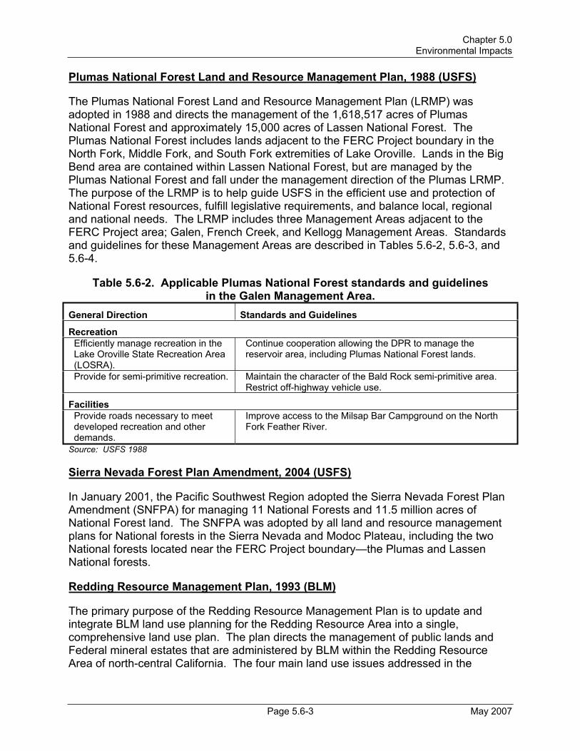
Chapter 5.0 Environmental Impacts
Page 5.6-3 May 2007
Plumas National Forest Land and Resource Management Plan, 1988 (USFS)
The Plumas National Forest Land and Resource Management Plan (LRMP) was adopted in 1988 and directs the management of the 1,618,517 acres of Plumas National Forest and approximately 15,000 acres of Lassen National Forest. The Plumas National Forest includes lands adjacent to the FERC Project boundary in the North Fork, Middle Fork, and South Fork extremities of Lake Oroville. Lands in the Big Bend area are contained within Lassen National Forest, but are managed by the Plumas National Forest and fall under the management direction of the Plumas LRMP. The purpose of the LRMP is to help guide USFS in the efficient use and protection of National Forest resources, fulfill legislative requirements, and balance local, regional and national needs. The LRMP includes three Management Areas adjacent to the FERC Project area; Galen, French Creek, and Kellogg Management Areas. Standards and guidelines for these Management Areas are described in Tables 5.6-2, 5.6-3, and 5.6-4.
Table 5.6-2. Applicable Plumas National Forest standards and guidelinesin the Galen Management Area.
General Direction Standards and Guidelines
Recreation Efficiently manage recreation in the Lake Oroville State Recreation Area (LOSRA).
Continue cooperation allowing the DPR to manage the reservoir area, including Plumas National Forest lands.
Provide for semi-primitive recreation. Maintain the character of the Bald Rock semi-primitive area. Restrict off-highway vehicle use.
FacilitiesProvide roads necessary to meet developed recreation and other demands.
Improve access to the Milsap Bar Campground on the North Fork Feather River.
Source: USFS 1988
Sierra Nevada Forest Plan Amendment, 2004 (USFS)
In January 2001, the Pacific Southwest Region adopted the Sierra Nevada Forest Plan Amendment (SNFPA) for managing 11 National Forests and 11.5 million acres of National Forest land. The SNFPA was adopted by all land and resource management plans for National forests in the Sierra Nevada and Modoc Plateau, including the two National forests located near the FERC Project boundary—the Plumas and Lassen National forests.
Redding Resource Management Plan, 1993 (BLM)
The primary purpose of the Redding Resource Management Plan is to update and integrate BLM land use planning for the Redding Resource Area into a single, comprehensive land use plan. The plan directs the management of public lands and Federal mineral estates that are administered by BLM within the Redding Resource Area of north-central California. The four main land use issues addressed in the

Draft Environmental Impact Report Oroville Facilities Relicensing—FERC Project No. 2100
May 2007 Page 5.6-4
Table 5.6-3. Applicable Plumas National Forest standards and guidelinesin the French Creek Management Area.
General Direction Standards and Guidelines
Recreation Efficiently manage recreation in the Lake Oroville State Recreation Area (LOSRA).
Continue cooperation allowing DPR to manage the reservoir area, including Plumas National Forest lands.
Provide developed recreation facilities/programs to meet demand while reducing unit costs.
Maintain Rogers Cow Camp Campground, but operate as a self-service facility with no developed water supply. Close when major expenditure is required.
Visual Resources Maintain pleasing visual corridors. Minimize the visual impact of transmission lines and
hydroelectric facilities.
WildlifeMaintain species viability. Provide suitable bald eagle foraging habitat along the North
Fork upstream from Lake Oroville.
Water Protect and where necessary, improve water quality.
Maintain and construct additional erosion control works when needed to control excessive erosion and sedimentation from the French Creek basin.
FacilitiesUpgrade forest arterials and collectors.
Reconstruct the Oroville-Quincy Highway as part of the Forest Highway System. Reconstruct the Stanwood Saddle Road in cooperation with Butte County.
Source: USFS 1988
Redding Resource Management Plan are land tenure adjustment, recreation management, access, and forest management.
Final Restoration Plan for the Anadromous Fish Restoration Program, 2001 (USFWS)
The Final Restoration Plan for the Anadromous Fish Restoration Program (AFRP) was established by USFWS to increase the natural production of anadromous fish in the Central Valley of California under authority of the Central Valley Project Improvement Act. The restoration plan is a programmatic-level description of the AFRP in broad and general terms, and will be used to guide the long-term development of the AFRP. The AFRP coordinates restoration efforts with those used by other groups, such as DFG and the CALFED Bay-Delta Program.

Chapter 5.0 Environmental Impacts
Page 5.6-5 May 2007
Table 5.6-4. Applicable Plumas National Forest standards and guidelinesin the Kellogg Management Area.
General Direction Standards and Guidelines
Recreation Protect and enhance recreation use of the Middle Fork of the Feather River.
Manage Wildlife Scenic Zones consistent with the Wild and Scenic Rivers Act.
Provide for semi-primitive recreation. Maintain the semi-primitive character of the Middle Fork and Bald Rock areas without roads.
Expand and improve the trail system.
Nominate Hartman Bar Trail as a National Recreation Trail when right-of-way is secured; improve facilities to meet planned uses.
WildlifeProtect and improve emphasis species habitat.
Coordinate projects affecting wild trout streams with DFG. Provide suitable peregrine falcon habitat in the Bald Rock Dome area.
FacilitiesUpgrade forest arterials and collectors.
Improve the Milsap Bar Campground access road as use studies show need to meet demand.
Special AreasProtect unique scenic values. Continue special management of Feather Falls Scenic Area;
recommend designation of Feather Falls as a National Natural Landmark.
Protect unique scenic and botanic values.
Preserve the champion ponderosa pine adjacent to the Hartman Bar Trail.
Source: USFS 1988
California’s Water Future: A Framework for Action, 2000 (CALFED Bay-Delta Program Agencies)
In 1994, the State of California and the federal government signed a Framework Agreement pledging cooperation on a long-term plan to address chronic water supply and environmental problems in the Bay-Delta. The CALFED Bay-Delta Program is a collaborative effort among 23 State and federal agencies (CALFED Agencies) to improve water supplies in California and the health of the Bay-Delta watershed.
5.6.1.2 State Plans, Policies, Regulations, and Laws
The State of California owns and manages a significant amount of land in the Project area. Several agencies are responsible for the management of State land and have developed management plans for guidance. State agencies that have management responsibilities for State lands in the Project area include DWR, DPR, and DFG. In addition to these three State agencies, the California Department of Forestry and Fire Protection (CDF) has developed management plans that influence land and resource management activities in the Project area.

Draft Environmental Impact Report Oroville Facilities Relicensing—FERC Project No. 2100
May 2007 Page 5.6-6
California Outdoor Recreation Plan, 2002 (DPR)
The California Outdoor Recreation Plan (CORP) was designed to meet the specific program responsibilities of the Federal Land and Water Conservation Fund Act, whose concerns are outdoor recreation, land acquisition, facility development, redevelopment, and rehabilitation. The primary objective of the CORP is to determine the outdoor recreation issues that are most critical in California, and to explore the most appropriate actions by which public agencies—State, federal, and local—might best address them.This plan is comprehensive in its scope, considering the full range of outdoor recreation issues throughout the entire State.
Lake Oroville State Recreation Area Resource Management Plan and General Development Plan, 1973 (DPR)
The current Lake Oroville State Recreation Area (LOSRA) General Development Plan, as amended, was developed by DPR in 1973. DPR released a public draft of a new General Plan in 2005, but it has not yet undergone the CEQA review process and has not been adopted by the Parks and Recreation Commission. The Development Plan describes allowable recreational uses and intensities for various areas around Lake Oroville. Recreational use intensities described in the Development Plan are primarily tied to slope and resource protection constraints.
Lake Oroville State Recreation Area General Development Plan Amendment—Lime Saddle Area, 1988 (DPR)
The LOSRA General Development Plan Amendment—Lime Saddle Area was approved by the State Park Commission in 1988. The Plan was intended to specifically address the changes needed at the Lime Saddle Marina.
Comprehensive Statewide Historic Preservation Plan for California, 2000–2005 (2001) (DPR Office of Historic Preservation)
The Comprehensive Statewide Historic Preservation Plan for California (HPP) was developed over the course of several years based upon input from both conservation professionals and the public. The HPP describes the vision for historic preservation and provides guidance on planning procedures for the identification, registration, protection, and preservation of important historical resources. Provisions for the periodic review and revision of the HPP every 5 years intend to ensure that changing needs and preservation priorities are being met.
The California Water Plan Update, Bulletin 160 Series (DWR)
The Bulletin 160 series assesses California’s water needs and evaluates water supplies to quantify the gap between future water demands and water supplies. The series presents a statewide overview of current water management activities and provides water managers with a framework for making decisions. Bulletins 160-93, 160-98, and 160-05 are the latest in the series and evaluate water management options that could improve California’s water supply reliability.

Chapter 5.0 Environmental Impacts
Page 5.6-7 May 2007
Lake Oroville Fisheries Habitat Improvement Plan, 1995 (DWR)
In response to the September 22, 1994, FERC Order, DWR adopted the Lake Oroville Fisheries Habitat Improvement Plan in 1995 to improve fish habitat and establish a schedule for implementation. A major plan objective includes increasing the productivity of fisheries within specific areas and the entire lake.
Oroville Wildlife Area Management Plan, 1978 (DFG)
In 1962, the Director of DWR declared that public interest and necessity required the acquisition of the Oroville Borrow Area (the clay source for the construction of the Lake Oroville Dam) for fish and wildlife enhancement and recreation. In total, 5,500 acres were transferred from DWR to DFG for creation of the Oroville Wildlife Area (OWA) on August 12, 1968. In 1978, DFG developed the Oroville Wildlife Area Management Plan. The purpose of the management plan was to provide for the preservation and enhancement of the OWA and for the reasonable use and enjoyment by the public.
California Regulations on Hunting and Other Public Uses on State and Federal Areas, 2002 (DFG)
The California Regulations on Hunting and Other Public Uses on State and Federal Areas is not a comprehensive plan per se, but it does govern hunting on State and federally owned lands and includes specific management direction for the OWA. Included in the regulations are hunting license provisions and requirements; application and fee information; a listing of all hunting areas throughout the state, including wildlife areas, recreation areas, and national forests; and detailed information regarding area locations and boundaries, hunting practices and regulations, permit requirements, and firearms and archery equipment regulations in each hunting area.
California Fire Plan: A Framework for Minimizing Costs and Losses From Wildland Fire, 1996 (CDF and State Board of Forestry)
In 1996, the State Board of Forestry (SBF) and CDF adopted the California Fire Plan, a comprehensive strategy for wildland fire protection in California. The fire plan is the State’s management guidance for identifying and working to reduce the risk and devastation caused by wildfire. The fire plan, updated most recently in 1999, targets pre-fire management measures geared at reducing fire fighting costs and property losses, increasing firefighter safety, and contributing to ecosystem health. The fire plan is a cooperative effort between the SBF and CDF.
Fire Management Plan, 2002 (CDF Butte Unit)
The Butte Unit Fire Management Plan documents the assessment of fire management within the Butte Unit (Butte County and a portion of Plumas County) and identifies strategic areas for pre-fire planning and fuel treatment to reduce destruction and costs associated with wildfire. The plan systematically assesses the existing level of wildland fire protection service, identifies high-risk and high-value areas where potential exists

Draft Environmental Impact Report Oroville Facilities Relicensing—FERC Project No. 2100
May 2007 Page 5.6-8
for costly and damaging wildfires, ranks these areas in terms of priority needs, and prescribes methods to reduce future costs and losses.
California Regional Water Quality Control Board, Central Valley Region, Water Quality Control Plan, Fourth Edition, 2006
The California Regional Water Quality Control Board, Central Valley Region, first adopted a Basin Plan in 1975 for the entire Sacramento and San Joaquin River Basins. Several editions have been adopted since then, with the current, fourth edition dated 2006. Basin Plan objectives relevant to the Oroville Facilities are described in Section 4.2.
5.6.1.3 Local Plans, Policies, Regulations, and Laws
There are three local entities in the Oroville Facilities Project area that have land planning and/or management responsibilities. The Butte County Association of Governments (BCAG) is the Metropolitan Planning Organization and Regional Transportation Planning Agency and is responsible for the preparation of all federal and State transportation plans and programs for securing transportation funds. BCAG is an association of local governments formed by Butte County and the cities of Biggs, Chico, Gridley, and Oroville and the Town of Paradise. In addition to BCAG, Butte County and the City of Oroville also have comprehensive and/or management plans for lands in the Project area.
Although the majority of land in the Project area is managed by State agencies, there are considerable city and county lands within the relicensing study area.
County Plans
Butte County General Plan, 1971, as amended (County of Butte)
Local governments have been directed by the State of California to prepare and adopt a general plan per Section 65302(a) of the California Government Code. In compliance with California Law, the Butte County General Plan was adopted in 1971 by the County of Butte and the BCAG. The purpose of this document is to provide a complete statement of the policies and intentions regarding future development of land over a planning horizon of 20 years, which extends to the year 2016. Table 5.6-5 describes the policies included within the Butte County General Plan that relate to the Oroville Facilities.
Butte County 2001 Regional Transportation Plan 2001
The Butte County Regional Transportation Plan (RTP) is a 20-year long-range plan that is intended to attain an efficient and environmentally sound multi-modal transportation system. Land use coordination policies in the RTP are intended to facilitate the development of the most efficient and effective transportation system possible through existing and future land development forms. The RTP makes reference to its support

Chapter 5.0 Environmental Impacts
Page 5.6-9 May 2007
for the general projects included in the Countywide Bikeway Master Plan, as well as support for the 41-mile bicycle trail loop around the Feather River, and trails located within the Lake Oroville State Recreation Area (LOSRA).
Table 5.6-5. Butte County General Plan policies related to the Oroville Facilities.Element Policy Statement
Land Use Biological Habitat: Lake Oroville and Butte County's larger streams are highly valuable habitats for trout, salmon, bass, and other game fish. Several rare and/or endangered plant and animal species are found within the county. Policy 6.5.a. Regulate development in identified winter deer ranges to facilitate the survival of deer herds. Policy 6.5.b. Prevent development and site clearance other than river bank protection of marshes and significant riparian habitats. Policy 6.5.c. Limit development which would increase sediment loads in prime fishing waters. Policy 6.5.d. Regulate development to facilitate survival of identified rare or endangered plants and animals. Geologic Hazards: The risk of landslides is greatest in areas with steep slopes, weak rock, and high rainfall; some areas around Lake Oroville and its branches have very high risk. Erosion potential varies by the same factors but is greatest in granite areas. Findings and policies on these subjects and other geologic hazards are presented in the Safety Element adopted in 1977. Policy 7.4.a. Correlate allowable density of development to potential for landslides, erosion and other types of land instability.
Open Space Open Space for Outdoor Recreation: The DPR manages the extensive recreation facilities around Lake Oroville and the Thermalito Bays. Policy L. Butte County should encourage the DPR to complete their development of recreational facilities in the LOSRA.
Scenic Highways
Eligible State Scenic Highways: Highway 70 north of Highway 149 is eligible as a State Scenic Highway, although not officially designated. Policy 1. Protect valuable scenic areas for enjoyment by residents and visitors. Policy 5. Locate and design utility structures to minimize visual impact, where economically feasible. Policy 6. Encourage compatible land use patterns in scenic corridors. Policy 8. Consider economic impacts on property affected by a scenic highway designation.
Recreation Policy 5. Lake Oroville and Facilities: Proposed development (parking, camp, picnic, boat ramp, comfort station, trailer, food, gasoline, oil, water, observation points and other facilities to serve the recreation minded public) at the following facilities: Lime Saddle, Foreman Creek, Bloomer, Craig, Kelly Ridge, Forebay, Loafer Creek, Goat Ranch, Afterbay, Potter Ravine, Fish Hatchery, etc. Development Agencies: County, Recreation District and DPR.
Source: Butte County 2000

Draft Environmental Impact Report Oroville Facilities Relicensing—FERC Project No. 2100
May 2007 Page 5.6-10
Countywide Bikeway Master Plan, 1998
The primary purpose of the Countywide Bikeway Master Plan is to designate a regional bikeway system for Butte County that focuses on areawide bikeway connections. The Bikeway Plan mentions the Oroville Facilities specifically, as one of its policies is to “emphasize connections to regional recreation centers, such as Lake Oroville and Bidwell Park…”.
Municipal Plans
City of Oroville General Plan, 1995 (City of Oroville)
The City of Oroville General Plan is a statement of Oroville’s vision of its long-term future, focusing on the physical components that comprise the City. The General Plan consists of eight sections: (1) land use; (2) design; (3) circulation; (4) open space, natural resources, and conservation; (5) public facilities and services; (6) safety; (7) noise; and (8) housing goals, objectives, policies, and designations. The objectives and goals outlined in the general plan are intended to be the framework within which the City will make future decisions related to the community. Table 5.6-6 describes the policies included within the general plan for the City of Oroville that relate to the Oroville Facilities.
Bicycle Transportation Plan, 1998 (City of Oroville)
The City of Oroville Bicycle Transportation Plan, adopted in December 1998, provides the most up-to-date policies for bicycle transportation in the City of Oroville. The City of Oroville plans all bikeways within its “Sphere of Influence,” although they are ultimately outside of the city’s jurisdiction. The planning and implementation of bikeways is not a mandated process, but one undertaken by communities at their discretion.
5.6.2 Impact Thresholds
The following thresholds are used to determine whether the alternatives would have a significant effect on land use. There would be a significant impact if the alternatives would:
5.6-a: Physically divide an established community;
5.6-b: Conflict with any applicable land use plan or regulation of an agency with jurisdiction over the project (including but not limited to the general plan, specific plan, and zoning ordinance) adopted for the purpose of avoiding or mitigating an environmental effect; or
5.6-c: Conflict with any applicable Habitat Conservation Plan or Natural Community Conservation Plan.

Chapter 5.0 Environmental Impacts
Page 5.6-11 May 2007
Table 5.6-6. City of Oroville General Plan policies that mention the Oroville Facilities.
Element Policy Statement Policy 4x. Request the State to landscape and develop the Thermalito Afterbay as a destination water recreation park which defines the western boundary of the community in accordance with the State’s original master plan of recreation development associated with the FERC permit.
City Design
Policy 4y. Encourage the efforts of the Feather River Parks and Recreation Department in the North Forebay, Nelson Ballpark expansion, and development of River Bend Park. Policy 6.11s. Coordinate with the DFG to ensure the ongoing operation of the Feather River Fish Hatchery.
Open Space, Natural Resources andConservation
Policy 6.11w. Work with the DFG to ensure the preservation and enhancement of species or resident and anadromous fish along the Feather River, in Lake Oroville, and throughout the Project area. Policy 8.10e. Monitor studies related to induced seismicity; if further studies establish a conclusive relationship between reservoir drawdown, refilling, and seismic activity, encourage the DWR to manage the Oroville Dam water regime to reduce risk (evidence thus far suggests a relationship between reservoir drawdown, refill, and subsequent seismic activity. This was seen in the 1975 Cleveland Hills earthquake, thought to have occurred after unprecedented drawdown and refilling of Lake Oroville).Policy 8.20m. Identify critical facilities in flood hazard areas and within the Oroville Dam inundation area, and seek ways to improve their level of protection, if possible (critical facilities provide fire and emergency services, water, electricity, gas supply, sewage disposal, communications, and transportation).
Safety
Policy 8.20o. In the event of dam failure on the Oroville Dam, implement emergency measures consistent with the city’s Multi-hazard Functional Disaster Plan (Dam failure, while considered unlikely, is among the hazards mentioned in the City’s Multi-hazard Functional Disaster Plan).
Source: City of Oroville 1995
5.6.3 Method of Analysis
The methodology used to evaluate potential land use effects considered baseline information provided in PDEA Section 5.8.1, Land Use Affected Environment, assummarized from SP-L1, Land Use Study, and SP-L2, Land Management.
In addition, the analysis included a review of the alternatives in the context of established local, State, or federal land use and management plans to determine if the alternatives are consistent with such plans. The plan consistency analysis in this section focused on land use and management–related plans only. The consistency of such plans is evaluated in detail in Chapter 9.0, Consistency with Comprehensive Plans. All plan consistency analyses are based on information acquired as part of SP-L3, Comprehensive Plan Consistency.
Other land use and management–related studies were also used, including SP-L4, Aesthetic/Visual Resources; SP-L5, Fuel Load Management Evaluation; and SP-R4,

Draft Environmental Impact Report Oroville Facilities Relicensing—FERC Project No. 2100
May 2007 Page 5.6-12
Assess Relationship of Fish/Wildlife Management and Recreation, to help assess the effects of the alternatives on land use, land management, and planning.
5.6.4 Impacts and Mitigation Measures
In addition to the Proposed Project, this DEIR analyzes the No-Project Alternative and the FERC Staff Alternative. All alternatives analyzed result in no impacts to land use and therefore, no mitigation is required.
Impact 5.6-a: Physically Divide an Established Community.
There are no measures that have the potential to physically divide an established community.
Impact 5.6-b: Conflict with Any Applicable Land Use Plan or Regulation of an Agency with Jurisdiction over the Project (Including but Not Limited to the General Plan, Specific Plan, and Zoning Ordinance) Adopted for the Purpose of Avoiding or Mitigating an Environmental Effect.
There are no measures that have the potential to conflict with any applicable land use plan or regulation of an agency with jurisdiction over the project (including but not limited to the general plan, specific plan, and zoning ordinance) adopted for the purpose of avoiding or mitigating an environmental effect.
Impact 5.6-c: Conflict with Any Applicable Habitat Conservation Plan or Natural Community Conservation Plan.
There are no measures that have the potential to conflict with any applicable Habitat Conservation Plan or Natural Community Conservation Plan.

Chapter 5.0 Environmental Impacts
Page 5.7-1 May 2007
5.7 RECREATIONAL RESOURCES
5.7.1 Regulatory Setting
This subsection describes the current responsibilities and activities of four primary State agencies, and other local and federal agencies, as related to recreation management.
In 1961, the California Legislature passed the Davis-Dolwig Act (California Water Code Sections 11900–11925), which defined responsibilities of four State agencies (DWR, DPR, DFG, and California Department of Boating and Waterways [DBW]) for providing recreational opportunities and fish and wildlife enhancements as part of the SWP, which includes the Oroville Facilities. DWR is charged with planning for public recreation and fish and wildlife preservation and enhancement in connection with the development of SWP facilities. This duty involves acquiring land and locating and constructing all works and project features so as to allow for fish and wildlife enhancement and recreational uses following construction of the project. DPR is authorized to design, construct, operate, and maintain public recreation facilities. DFG is responsible for managing fish and wildlife resources. DBW, in turn, is charged with planning, designing, and constructing boating-related facilities.
Lands, facilities, and recreational interests in the project area are also owned and managed by two federal land management agencies, BLM and USFS, and a local parks agency, the Feather River Recreation and Parks District (FRRPD). The properties and management responsibilities of each agency are detailed in a series of deeds, agreements, and transfers between the agencies involved.
Relevant agency ownership, management responsibilities, and current management practices throughout the project area are presented below by geographic area. Additional detail on organizational structure and budget are provided in the report for Relicensing Study Plan R-5 (SP-R5), Assessment of Recreation Areas Management. Under FERC regulations, DWR is ultimately responsible for public access, recreation opportunities, and associated development within the FERC Project boundary.
5.7.1.1 Management of Lake Oroville State Recreation Area
The Lake Oroville State Recreation Area (LOSRA) contains most of the recreation waters, land, and facilities within the FERC Project boundary, comprising approximately 28,000 of the approximately 41,100 acres within the FERC Project boundary.
California Department of Water Resources
DWR has transferred management responsibilities (“recreational interest”) for most lands, waters, and recreation facilities within the LOSRA to DPR. Although DWR does not manage the majority of the recreational opportunities and facilities in the LOSRA or the project area, it is responsible, under its existing FERC License, for implementing a variety of recreation-related projects and improvements, ensuring funding, operation, development, and management of current and additional recreation facilities within the

Draft Environmental Impact Report Oroville Facilities Relicensing—FERC Project No. 2100
May 2007 Page 5.7-2
project area. Although in many cases DWR is not involved in the direct implementation of recreation improvements and programs at the field level, it is ultimately DWR’s responsibility to ensure that all improvements, maintenance, and studies prescribed in the FERC License are properly carried out. Consistent with its responsibilities, DWR works with DPR, DBW, and DFG to provide for recreational opportunities and funding throughout the Oroville Facilities as required by FERC.
California Department of Parks and Recreation
As the manager of the LOSRA, DPR is the primary provider of recreation opportunities and facilities within the project area. DPR’s Core Programs, linked directly to the agency’s mission, include Resource Protection, Education and Interpretation, Facilities, Public Safety, and Recreation (DPR 2001). Routine tasks performed by DPR staff include collecting fees and monitoring attendance; cleaning and maintaining restrooms and toilet buildings; servicing trash receptacles; maintaining camping and day use areas including launch ramps, courtesy docks, and 47 miles of trails; monitoring and maintaining buoys and vessels; and maintaining recreation area grounds and landscaping. DPR and DWR maintain a floating debris removal program on Lake Oroville whereby boats are used to picked up debris and deliver it to collection points (cove areas with debris containment booms), where it is collected from the shore after the reservoir has receded.
DPR is also responsible for carrying out boat safety inspections and providing safety patrols at Lake Oroville, Thermalito Forebay, and the Diversion Pool. (Patrols are not regularly conducted in the Diversion Pool and Thermalito Forebay due to relatively low levels of boating activity.) Less frequent tasks include road maintenance for approximately 21 miles of road, maintenance of all park utilities (including electrical, water, and wastewater facilities), and capital improvement of all recreational facilities. Under the direction of DPR, two private concessionaires operate and maintain facilities at Bidwell Canyon and Lime Saddle Marinas, subject to DPR contracts and oversight (pers. comm., Feazel 2002).
Utility services in the recreation area are overseen by a water/sewer plant supervisor.In addition to LOSRA staff, DPR’s other Northern Buttes District administrative staff provide additional aid to all units in the DPR District. DPR annually hires additional seasonal support staff in the summer to operate entrance stations and carry out basic facility maintenance tasks.
The Seventh Generation: The Strategic Vision of California State Parks (DPR 2001) outlines the strategies and management practices that DPR follows in managing parks throughout the State. DPR manages interpretive programs, most Lake Oroville Visitors Center activities, special events coordination, and general recreational opportunities with that guiding document in mind. More specific to the project area, DPR is currently updating the General Development Plan for LOSRA. The General Development Plan update establishes a long-range vision for the park and provides guidelines to protect and improve the park's natural, cultural, and recreational values.

Chapter 5.0 Environmental Impacts
Page 5.7-3 May 2007
Although DPR manages the majority of LOSRA’s recreational aspects, as stated, DWR bears the ultimate responsibility under the current FERC License for ensuring funding, development, operation, and management of current and additional recreation facilities at the Oroville Facilities. In addition, the Davis-Dolwig Act requires DWR to plan for and acquire land for recreation in conjunction with all SWP development. Under the Davis-Dolwig Act, DPR has the authority to design, construct, operate, and maintain recreation facilities of the SWP. DPR has a budget that is controlled and appropriated annually by the California Legislature.
California Department of Boating and Waterways
DBW administers a number of programs, including boating and aquatic safety education and training programs, boat and yacht licensing programs, and programs that fund the development of public-access boating facility projects. DBW funds and constructs various projects at the LOSRA and the Oroville Wildlife Area (OWA) related to boating and boating-related facilities, including boat-in facilities, launch ramps and associated parking areas, floating restrooms, other restrooms at boat ramps, and general renovation of boating facilities. Projects pursued by DBW are typically proposed following suggestions from other agencies and from the public through DBW’s public outreach programs. Following construction, the responsibility for operation and maintenance of facilities is turned over to the appropriate land managing agency—in this case it is DPR (LOSRA) or DWR (Thermalito Afterbay). DBW neither owns nor manages any recreational facilities or activities within the study area (pers. comm., DiGiorgio 2003).
DBW has spent $9.4 million since 1995 on constructing and maintaining boating facilities that support boating at LOSRA. When this amount is adjusted (normalized) to 2002 using the Consumer Price Index for California, DBW expenditures for recreation-related projects at the LOSRA total $18 million.
California Department of Fish and Game
DFG management in the LOSRA is limited to the enforcement of hunting and fishing regulations and the California Fish and Game Code, management of the fish stocking program, and participation in biological studies (pers. comm., Atkinson 2003). DFG also participates in some habitat improvement programs, the management of wildlife and special-status species habitat projects, and related issues falling under DFG jurisdiction.
U.S. Bureau of Land Management
BLM is responsible for scattered lands managed under the direction of the 1993 Redding Resource Management Plan discussed below. Within the FERC Project boundary, BLM manages approximately 3,852 acres of land in scattered, noncontiguous parcels along the West Branch and the North, Middle, and South Forks of Lake Oroville.BLM lands within the FERC Project boundary represent 9.4 percent of the total 41,142 acres of the Oroville Facilities. Of the total acres of BLM-administered public lands within the FERC Project boundary, approximately half are submerged under Lake
Draft Environmental Impact Report Oroville Facilities Relicensing—FERC Project No. 2100
May 2007 Page 5.7-4
Oroville. Currently, BLM does not actively manage recreation on any lands within the FERC Project boundary (pers. comm., Williams 2003; pers. comm., Ritter 2002).
U.S. Forest Service
Within the LOSRA boundary, there are 1,811 acres of Plumas National Forest lands, which comprise several fragmented holdings distributed proportionately between the North, Middle, and South Forks of Lake Oroville. There are also 228 acres of Lassen National Forest lands within the LOSRA, located on the North Fork arm of the reservoir, which are administered by the Plumas National Forest (pers. comm., Graham 2004).All National Forest lands within the FERC Project boundary are part of the USFS French Creek, Galen, Kellogg, and Feather Falls Management Areas, where ownership is a checkerboard of private, State, and federally owned parcels (USFS 1988).
The French Creek, Galen, Kellogg, and Feather Falls Management Areas, including those areas that overlap with the area, are managed with a number of specific goals related to resource conservation, provision of high-quality recreational opportunities, and protection of visual resources. The Plumas Land and Resource Management Planspecifically calls for the promotion of efficient recreation management in both the French Creek and Galen Management Areas by allowing DPR to manage recreation on Plumas National Forest lands that fall within the LOSRA boundary, per a 1978 Memorandum of Agreement (MOA) between the two agencies (USFS 1988; USFS and DPR 1978).
5.7.1.2 Management of Oroville Wildlife Area
The OWA consists of 2 informal subunits: the 5,700-acre original management area adjoining the Feather River (including the area formerly known as the Oroville Borrow Area) owned by DFG, and the approximately 6,000 acres of Thermalito Afterbay and surrounding lands managed by DFG under an agreement with DWR. The non-Thermalito Afterbay portion of the OWA is managed primarily for dispersed types of recreation such as hunting, fishing, and bird watching with minimal developed facilities. Waterfowl and upland game hunting are permitted in the OWA, including in Thermalito Afterbay. The area is managed primarily for day use, but primitive camping areas are located near the Larkin Road access point (Thermalito Afterbay Outlet).1 Limited gravel extraction also occurs in a few locations. The Thermalito Afterbay subunit is also managed for dispersed types of recreation and for day use only, but it also has three additional developed boat launching and day use facilities.
California Department of Fish and Game
DFG’s goals in managing the lands and facilities at wildlife areas are to maximize the amount and quality of habitat available for fish and wildlife, while also providing for use and enjoyment of the area by the public (DFG 1978; pers. comm., Atkinson 2003; pers. comm., Rischbieter 2003). Ideally, DFG manages wildlife areas to protect and enhance
1 Primitive camping was allowed at another interior OWA location, One-Mile Pond, until March 2004. The designation of this area for camping was terminated due to the conflicts it presented with adjacent areas of the OWA being closed to nighttime use.

Chapter 5.0 Environmental Impacts
Page 5.7-5 May 2007
fish and wildlife habitats and the populations that depend on them, while allowing compatible recreation in the areas used by the public only to the extent that such uses do not interfere with the primary goals of fish and wildlife management.
DFG manages the OWA under the 1978 Oroville Wildlife Area Management Plan (DFG 1978), the California Fish and Game Commission’s Hunting and Other Public Uses on State and Federal Lands California Regulations (DFG 2002), and the California Fish and Game Code, Sections 1525–1530 (OLC 2003). DFG, with limited assistance from DWR, works to achieve the objectives laid out in these documents through its lands, facilities, and fish and wildlife management strategies and practices. Additionally, as the State agency responsible for enforcement of hunting and fishing regulations on all public and private lands, DFG coordinates with the other management agencies in the area to ensure that regulations are enforced.
DFG management responsibilities at the OWA include facilities management, maintenance (such as solid waste collection and removal), boundary posting, fencing and signage repairs, code enforcement, and patrolling for illegal uses such as dumping and unauthorized off-highway vehicle use. DFG management actions also include habitat enhancement and inventorying and monitoring of vegetation and wildlife, including the monitoring of habitat improvement areas (pers. comm., Atkinson 2003).DFG’s habitat enhancement program includes a wood duck nest-box program and dry land farming for nesting cover and improved wildlife forage. Fish and wildlife-related facilities also include hunting blinds located within the OWA.2
A unique aspect of the OWA, compared with other State Wildlife Areas in California, is the ongoing gravel mining activity. Mining is not typically consistent with the California Fish and Game Code or with any of the management goals set forth by DFG for wildlife areas. Leases providing for gravel extraction from the OWA are allowed due to legal agreements (developed prior to the designation as a wildlife area) that provide for this use, though some are a result of a land exchange between DFG and commercial gravel interests.
California Department of Water Resources
As a result of the 1993 Amended Recreation Plan, new day use facilities were constructed at Thermalito Afterbay by DWR in coordination with DFG (DWR 1993).DWR continues to manage two paved boat ramps and one car-top boat ramp and associated day use facilities on Thermalito Afterbay. The new facilities have led to increased use levels that may not be fully compatible with a designated wildlife area (pers. comm., Atkinson 2003). DWR also funds a contract with the Butte County Sheriff's Department for boat patrol on the Thermalito Afterbay portion of the OWA.
In 1993, an MOA, Development and Management of Thermalito Afterbay Brood Ponds and Surrounding Habitat, was created between DWR, DFG, and the California
2 DFG terminated day-to-day management activities and staffing at the OWA, effective March 1, 2004, owing to State budget shortfalls.

Draft Environmental Impact Report Oroville Facilities Relicensing—FERC Project No. 2100
May 2007 Page 5.7-6
Waterfowl Association to implement a plan for the development, operation, and maintenance of brood ponds and surrounding habitat to enhance wildlife at Thermalito Afterbay as part of the Central Valley Joint Venture Implementation Plan. DWR constructed 3 brood ponds, 1 per year following the MOA dated August 17, 1993 (DWR 2003).
5.7.1.3 Management of Recreation on the Feather River
About 10 miles of the Feather River, including about 5 miles of the Low Flow Channel (LFC), flows adjacent to and through the OWA; thus, recreation management of the river overlaps to a large extent with the OWA management discussed above. However, about 3 miles of the LFC, about half of which is within the FERC Project boundary, is upstream of the OWA and provides additional recreation opportunities.
The first three-quarters of a mile of the LFC below the Thermalito Diversion Dam is occupied by the Fish Barrier Pool, which is accessible to the public by nearby trails but which receives very little use. The Fish Barrier Pool and approximately 1 mile of the river downstream from the Fish Barrier Dam are within the FERC Project boundary. The Feather River Fish Hatchery occupies much of the right riverbank immediately below the Fish Barrier Dam. The remaining 1.5 miles of the river and adjacent riverbanks are outside the FERC Project boundary and are owned or managed by the City of Oroville or FRRPD, or are in private ownership.
Fishing Regulations
The segment of the Feather River in the project area is one of the most popular seasonal fishing destinations in the region, hosting tens of thousands of anglers each year (DWR 2001), most of whom are drawn by the well-known salmon and steelhead fisheries. The most popular location for anglers to congregate is at the Thermalito Afterbay Outlet within the OWA, but anglers also boat, wade, and use the riverbanks in the upstream section. DFG holds primary responsibility for fish and wildlife management within the State and therefore has jurisdiction to enforce DFG laws on all lands within the project area, including all of the Feather River. Most of the Feather River is open to fishing during certain periods each year. Fishing along the Feather River from the Fish Barrier Dam downstream to the Table Mountain bicycle bridge is prohibited year-round. Fishing from the Table Mountain Bridge to the State Route (SR) 70 bridge is permitted from January 1 to July 15 (barbless hooks only). Fishing is permitted throughout the year on the remainder of the river within the project area, but catch limits for trout and salmon vary by season.
5.7.1.4 Feather River Fish Hatchery (California Department of Water Resources and California Department of Fish and Game)
The Feather River Fish Hatchery was built in 1967 to compensate for the loss of salmon and steelhead trout spawning grounds due to the construction of Oroville Dam. The hatchery was designed as a relatively compact facility where a large number of adult salmon and steelhead could be held and artificially spawned.

Chapter 5.0 Environmental Impacts
Page 5.7-7 May 2007
The Feather River Fish Hatchery is funded by DWR and managed by DFG. DWR has assisted DFG with fish rearing and stocking, and with developing management protocols at the hatchery. The Fish Barrier Dam, located immediately upstream of the hatchery, prevents fish from traveling farther upstream. The flow over the Fish Barrier Dam maintains fish habitat in the LFC of the Feather River between the dam and the Thermalito Afterbay Outlet while providing attraction flow for the hatchery. Salmon and trout follow a fish ladder from the base of the Fish Barrier Dam up to the hatchery, where they are artificially spawned. Underwater viewing windows allow visitors to watch the fish as they swim and leap up the ladder. Hatchery facilities have an annual production capacity of 10 million fall-run salmon, 2 million spring-run salmon, and 450,000 steelhead (pers. comm., Kastner 2003).
Feather River Recreation and Park District
FRRPD, established by Butte County in 1952 to provide recreation and park services to the residents of the City of Oroville and surrounding communities, is a special assessment district encompassing 700 square miles of southeastern Butte County (City of Oroville 1995; FRRPD 2002). FRRPD provides a variety of recreation programs to the community and owns or leases several parks and sports facilities, several of which lie near or adjacent to the FERC Project boundary (City of Oroville 1995; FRRPD 2003).Riverbend Park and the adjacent Bedrock Park on the Feather River are important community assets and are linked to the Diversion Pool and the OWA recreation sites within the area by a paved segment of trail (part of the 41-mile Brad Freeman Trail).
5.7.2 Impact Thresholds
The following thresholds are used to determine whether the alternatives would result in significant effects on recreational resources. There would be a significant impact if the alternatives would:
5.7-a: Cause a direct or indirect substantial physical degradation of either public recreation uses or public recreational facilities;
5.7-b: Conflict with local, State, or federal agency recreation management plans; or
5.7-c: Substantially diminish values for which a stream segment is considered eligible for Wild and Scenic River System inclusion.
5.7.3 Method of Analysis
Potential impacts on recreation resources were assessed by qualitative methods. Baseline data for this assessment were collected during Oroville Facilities Relicensing studies. The Recreation and Socioeconomics Work Group developed 17 study plans to guide 17 separate but interrelated recreation studies (2 additional studies investigated socioeconomic issues and related recreation spending). The 17 recreation studies provided a comprehensive source of information to define the affected environment and

Draft Environmental Impact Report Oroville Facilities Relicensing—FERC Project No. 2100
May 2007 Page 5.7-8
also supported assessment of the effects of the No-Project Alternative, the Proposed Project, and the FERC Staff Alternative on recreation resources, as described in Section 5.7.4 below. The 17 studies include the following:
SP-R1, Vehicular Access Study;
SP-R2, Recreation Safety Assessment;
SP-R3, Assessment of the Relationship of Project Operations and Recreation;
SP-R4, Relationship Assessment of Fish/Wildlife Management and Recreation;
SP-R5, Assessment of Recreation Areas Management;
SP-R6, ADA Accessibility Assessment;
SP-R7, Reservoir Boating;
SP-R8, Recreation Carrying Capacity;
SP-R9, Existing Recreation Use Study;
SP-R10, Recreation Facility Inventory and Condition Report;
SP-R11, Recreation and Public Use Impact Assessment;
SP-R12, Projected Recreation Use;
SP-R13, Recreation Surveys;
SP-R14, Assessment of Regional Recreation and Barriers to Recreation;
SP-R15, Recreation Suitability;
SP-R16, Whitewater and River Boating; and
SP-R17, Recreation Needs Analysis.
These relicensing studies provide information on existing and historical recreation conditions. Professional judgment based on thorough familiarity with the recreation resources and issues of the project gained over the course of the collaborative relicensing effort is also an important element in assessing effects on recreation quality or quantity. For detailed descriptions of study plan methodologies, please refer to each study plan report, which can be found at http://orovillerelicensing.water.ca.gov/.

Chapter 5.0 Environmental Impacts
Page 5.7-9 May 2007
5.7.4 Impacts and Mitigation Measures
The following section describes the beneficial effects and potentially adverse impacts of the Proposed Project, including both programmatic and project-level analyses. Table 5.7-1 indicates the SA articles or actions that could have an effect on recreation resources, and whether these effects are expected to be beneficial, less-than-significant, or would be less-than-significant following implementation of recommended mitigation measures.
In addition to the Proposed Project, this DEIR analyzes the No-Project Alternative and the FERC Staff Alternative. Impacts on recreation from implementing the FERC Staff Alternative are similar to those anticipated from implementation of the Proposed Project unless noted. Alternatives are identified as follows: NO (No-Project), PRO (Proposed Project), and FERC (FERC Staff Alternative). Effects are identified as follows: B (beneficial), LTS (less than significant), LTSM (less than significant with mitigation) and SU (significant and unavoidable). All alternatives analyzed result in less-than-significant impacts to recreation with the implementation of best management practices (BMPs), as described in Appendix D and included in both the Proposed Project and the FERC Staff Alternative, to address short-term, construction-related impacts, and no further mitigation would be required.

Dra
ft E
nviro
nmen
tal I
mpa
ct R
epor
t O
rovi
lle F
acilit
ies
Rel
icen
sing
—FE
RC
Pro
ject
No.
210
0
May
200
7 P
age
5.7-
10
Tabl
e 5.
7-1.
Env
ironm
enta
l effe
cts
on re
crea
tiona
l res
ourc
es.
Alte
rnat
ive(
s)
Art
icle
# a
nd T
itle
Leve
l of C
EQA
A
naly
sis
Nat
ure
of P
oten
tial I
mpa
ct(s
) Ef
fect
s
PR
O, F
ER
C
A10
2—G
rave
l Sup
plem
enta
tion
and
Impr
ovem
ent P
rogr
am (A
lso
see
B10
5)
Pro
gram
mat
ic
Aqu
atic
hab
itat i
mpr
ovem
ents
cou
ld
lead
to e
nhan
ced
fish
vigo
r and
nu
mbe
r, th
ereb
y en
hanc
ing
the
qual
ity
of th
e an
glin
g ex
perie
nce
with
in th
e pr
ojec
t are
a du
e to
incr
ease
d ca
tch
rate
s or
cat
chin
g la
rger
fish
.
B
PR
O, F
ER
C
A10
3—C
hann
el Im
prov
emen
t Pro
gram
(T
his
actio
n is
pro
gram
mat
ic; h
owev
er,
Moe
’s a
nd H
atch
ery
Ditc
h ac
tiviti
es a
re
proj
ect-l
evel
)
Pro
gram
mat
ic w
ith
som
e Pr
ojec
t el
emen
ts
Aqu
atic
hab
itat i
mpr
ovem
ents
cou
ld
lead
to e
nhan
ced
fish
vigo
r and
nu
mbe
r, th
ereb
y en
hanc
ing
the
qual
ity
of th
e an
glin
g ex
perie
nce
with
in th
e pr
ojec
t are
a du
e to
incr
ease
d ca
tch
rate
s or
cat
chin
g la
rger
fish
. C
onst
ruct
ion
of s
ever
al m
easu
res
coul
d ca
use
shor
t-ter
m d
isru
ptio
ns to
re
crea
tion
use
and
activ
ities
.
B/LT
S
PR
O, F
ER
C
A10
4—S
truct
ural
Hab
itat S
uppl
emen
tatio
n an
d Im
prov
emen
t Pro
gram
(SH
SI)
P
rogr
amm
atic
Aqu
atic
hab
itat i
mpr
ovem
ents
cou
ld
lead
to e
nhan
ced
fish
vigo
r and
nu
mbe
r, th
ereb
y en
hanc
ing
the
qual
ity
of th
e an
glin
g ex
perie
nce
with
in th
e pr
ojec
t are
a du
e to
incr
ease
d ca
tch
rate
s or
cat
chin
g la
rger
fish
. P
lace
men
t of h
abita
t stru
ctur
es c
ould
re
quire
the
clos
ure
of a
reas
to
recr
eatio
n. L
arge
woo
dy d
ebris
cou
ld
be a
haz
ard
to b
oate
rs a
nd s
wim
mer
s.
B/LT
S
PR
O, F
ER
C
A10
6—R
ipar
ian
and
Floo
dpla
in
Impr
ovem
ent P
rogr
am
Pro
gram
mat
ic
Aqu
atic
hab
itat i
mpr
ovem
ents
cou
ld
lead
to e
nhan
ced
fish
vigo
r and
nu
mbe
r, th
ereb
y en
hanc
ing
the
qual
ity
of th
e an
glin
g ex
perie
nce
with
in th
e pr
ojec
t are
a du
e to
incr
ease
d ca
tch
rate
s or
cat
chin
g la
rger
fish
. C
onst
ruct
ion
of s
ever
al m
easu
res
coul
d ca
use
shor
t-ter
m d
isru
ptio
ns to
re
crea
tion
use
and
activ
ities
.
B/LT
S
PR
O, F
ER
C
A11
0—La
ke O
rovi
lle W
arm
Wat
er F
ishe
ry
Pro
gram
mat
ic
Aqu
atic
hab
itat i
mpr
ovem
ents
cou
ld
B/L
TS

Cha
pter
5.0
E
nviro
nmen
tal I
mpa
cts
P
age
5.7-
11
May
200
7
Tabl
e 5.
7-1.
Env
ironm
enta
l effe
cts
on re
crea
tiona
l res
ourc
es.
Alte
rnat
ive(
s)
Art
icle
# a
nd T
itle
Leve
l of C
EQA
A
naly
sis
Nat
ure
of P
oten
tial I
mpa
ct(s
) Ef
fect
s
Hab
itat I
mpr
ovem
ent P
rogr
am
lead
to e
nhan
ced
fish
vigo
r and
nu
mbe
r, th
ereb
y en
hanc
ing
the
qual
ity
of th
e an
glin
g ex
perie
nce
with
in th
e pr
ojec
t are
a du
e to
incr
ease
d ca
tch
rate
s or
cat
chin
g la
rger
fish
. H
abita
t st
ruct
ures
cou
ld p
rovi
de o
bsta
cles
to
boat
ing,
may
affe
ct s
hore
acc
ess,
and
m
ay a
ffect
the
recr
eatio
n se
tting
.
PR
O, F
ER
C
A10
5—Fi
sh W
eir P
rogr
am
Pro
gram
mat
ic
Con
stru
ctio
n of
wei
rs c
ould
impa
ct
recr
eatio
n. W
eirs
cou
ld b
e im
pedi
men
ts to
boa
ting
and
wou
ld
decr
ease
am
ount
of a
rea
for f
ishi
ng
due
to c
reat
ion
of “N
o Fi
shin
g Zo
nes”
ar
ound
the
wei
rs.
LTS
PR
O, F
ER
C
A12
8—D
raft
His
toric
Pro
perti
es
Man
agem
ent P
lan:
P
oten
tially
Res
trict
Acc
ess
in th
e In
unda
tion
Zone
to S
peci
fic B
oat-i
n C
ampg
roun
ds (B
ICs)
as
App
ropr
iate
D
urin
g P
erio
ds o
f Low
Res
ervo
ir, a
nd
Elim
inat
e W
heel
ed M
otor
ized
Veh
icle
Use
w
ithin
the
Lake
Oro
ville
Flu
ctua
tion
Zone
Pro
gram
mat
ic
Clo
sure
of b
oat-i
n ca
mps
ites
coul
d af
fect
recr
eatio
n us
e. E
limin
atin
g un
auth
oriz
ed v
ehic
ular
acc
ess
coul
d re
duce
veh
icle
use
at s
ome
shor
elin
e ar
eas.
LTS
PR
O, F
ER
C
A11
2—C
ompr
ehen
sive
Wat
er M
onito
ring
Pro
gram
Pro
ject
(all
of A
112
exce
pt A
112[
a–c]
)
Wat
er q
ualit
y m
onito
ring
coul
d in
crea
se s
afet
y an
d en
hanc
e th
e re
crea
tion
expe
rienc
e.
B
PR
O, F
ER
C
A11
3—M
onito
ring
of B
acte
ria L
evel
s an
d P
ublic
Edu
catio
n P
roje
ct
Wat
er q
ualit
y m
onito
ring
and
educ
atio
n co
uld
incr
ease
saf
ety
and
enha
nce
the
recr
eatio
n ex
perie
nce.
B
PR
O, F
ER
C
A11
4—P
ublic
Edu
catio
n R
egar
ding
Ris
ks
of F
ish
Con
sum
ptio
n P
roje
ct
Edu
catio
n co
uld
incr
ease
saf
ety
and
enha
nce
the
recr
eatio
n ex
perie
nce.
B
PR
O, F
ER
C
A12
3—P
rovi
sion
of U
plan
d Fo
od fo
r N
estin
g W
ater
fow
l P
roje
ct
Terr
estri
al h
abita
t im
prov
emen
ts fo
r w
ildlif
e co
uld
impr
ove
wild
life
wat
chin
g op
portu
nitie
s an
d pr
ovid
e ad
ditio
nal
wild
life
for h
untin
g.
B

Dra
ft E
nviro
nmen
tal I
mpa
ct R
epor
t O
rovi
lle F
acilit
ies
Rel
icen
sing
—FE
RC
Pro
ject
No.
210
0
May
200
7 P
age
5.7-
12
Tabl
e 5.
7-1.
Env
ironm
enta
l effe
cts
on re
crea
tiona
l res
ourc
es.
Alte
rnat
ive(
s)
Art
icle
# a
nd T
itle
Leve
l of C
EQA
A
naly
sis
Nat
ure
of P
oten
tial I
mpa
ct(s
) Ef
fect
s
PR
O, F
ER
C
A12
4—P
rovi
sion
of N
est C
over
for U
plan
d W
ater
fow
l P
roje
ct
Terr
estri
al h
abita
t im
prov
emen
ts fo
r w
ildlif
e co
uld
impr
ove
wild
life
wat
chin
g op
portu
nitie
s an
d pr
ovid
e ad
ditio
nal
wild
life
for h
untin
g.
B
PR
O, F
ER
C
A12
5—In
stal
latio
n of
Wild
life
Nes
ting
Box
es
Pro
ject
Terr
estri
al h
abita
t im
prov
emen
ts fo
r w
ildlif
e co
uld
impr
ove
wild
life
wat
chin
g op
portu
nitie
s an
d pr
ovid
e ad
ditio
nal
wild
life
for h
untin
g.
B
PR
O, F
ER
C
A10
8—Fl
ow/T
empe
ratu
re to
Sup
port
Ana
drom
ous
Fish
Pro
ject
(A10
8.1
only
); P
rogr
amm
atic
(1
08.2
and
108
.3
only
)
Flow
and
tem
pera
ture
cha
nges
cou
ld
lead
to e
nhan
ced
fish
vigo
r and
nu
mbe
r, th
ereb
y en
hanc
ing
the
qual
ity
of th
e an
glin
g ex
perie
nce
with
in th
e pr
ojec
t are
a du
e to
incr
ease
d ca
tch
rate
s or
cat
chin
g la
rger
fish
. W
ater
te
mpe
ratu
re c
hang
es w
ould
like
ly b
e un
notic
eabl
e to
ang
lers
and
boa
ters
. P
oten
tial m
easu
res
to a
ddre
ss
tem
pera
ture
goa
ls c
ould
resu
lt in
ad
ditio
nal s
afet
y ris
ks, b
arrie
rs o
r im
pedi
men
ts to
recr
eatio
n, a
nd c
ould
be
nefit
fish
ing.
Fis
hing
cou
ld b
e be
nefit
ed b
y in
crea
sed
spaw
ning
; ho
wev
er, s
ome
angl
ers
may
find
w
adin
g m
ore
diffi
cult
at h
ighe
r wat
er
leve
ls.
Use
by
smal
l mot
oriz
ed fi
shin
g bo
ats
may
slig
htly
incr
ease
at h
ighe
r flo
ws.
B/LT
S
PR
O, F
ER
C
A12
2—C
onst
ruct
ion
and
Rec
harg
e of
B
rood
Pon
ds
Pro
ject
Terr
estri
al h
abita
t im
prov
emen
ts fo
r w
ildlif
e co
uld
impr
ove
wild
life
wat
chin
g op
portu
nitie
s an
d pr
ovid
e ad
ditio
nal
wild
life
for h
untin
g. T
herm
alito
A
fterb
ay w
ater
leve
l dra
wdo
wn
durin
g co
nstru
ctio
n co
uld
impa
ct A
fterb
ay
wat
er s
urfa
ce a
cces
s an
d re
crea
tiona
l an
glin
g at
exi
stin
g br
ood
pond
s.
B/LT
S

Cha
pter
5.0
E
nviro
nmen
tal I
mpa
cts
P
age
5.7-
13
May
200
7
Tabl
e 5.
7-1.
Env
ironm
enta
l effe
cts
on re
crea
tiona
l res
ourc
es.
Alte
rnat
ive(
s)
Art
icle
# a
nd T
itle
Leve
l of C
EQA
A
naly
sis
Nat
ure
of P
oten
tial I
mpa
ct(s
) Ef
fect
s
PR
O
A12
7—R
ecre
atio
n M
anag
emen
t Pla
n:
Con
stru
ctio
n of
Rec
reat
ion
Faci
litie
s,
Pro
vide
Add
ition
al A
llow
able
Use
s on
S
ome
Trai
ls, a
nd
Dep
loy
Two
New
Flo
atin
g C
amps
ites
in
the
Lim
e S
addl
e A
rea
and
Dep
loy
One
N
ew F
loat
ing
Cam
psite
in th
e W
est o
r N
orth
For
k A
reas
of t
he R
eser
voir
Pro
gram
mat
ic/
Pro
ject
Pro
visi
on o
f new
recr
eatio
n fa
cilit
ies
such
as
new
trai
ls, p
arki
ng a
reas
, re
stro
oms,
fish
cle
anin
g st
atio
ns,
beac
h, s
wim
min
g ar
eas,
sig
nage
, im
prov
ed v
ehic
ular
acc
ess
and
prov
isio
n of
boa
ting,
day
use
, ca
mpi
ng, t
he A
mer
ican
s w
ith
Dis
abili
ties
Act,
and
eque
stria
n an
d w
ildlif
e-w
atch
ing
faci
litie
s co
uld
incr
ease
recr
eatio
n us
e an
d en
hanc
e th
e re
crea
tion
expe
rienc
e by
offe
ring
impr
oved
recr
eatio
n op
portu
nitie
s, n
ew
recr
eatio
n op
portu
nitie
s at
som
e si
tes,
an
d su
ppor
t use
of t
he p
roje
ct a
rea
by
crea
ting
a w
ider
rang
e of
use
rs.
Con
stru
ctio
n of
sev
eral
mea
sure
s co
uld
caus
e sh
ort-t
erm
dis
rupt
ions
to
recr
eatio
n us
e an
d ac
tiviti
es.
Cha
ngin
g al
low
able
use
s m
ay d
ispl
ace
som
e us
ers,
but
wou
ld a
lso
prov
ide
addi
tiona
l tra
il op
portu
nitie
s.
Add
ition
al fl
oatin
g ca
mps
ites
may
sl
ight
ly d
ecre
ase
acre
age
avai
labl
e fo
r hi
gh s
peed
boa
t cru
isin
g.
B/LT
S
PR
O, F
ER
C
A10
7—Fe
athe
r Riv
er F
ish
Hat
cher
y w
ater
te
mpe
ratu
reP
roje
ct (1
07.2
) W
ater
tem
pera
ture
cha
nges
wou
ld
likel
y be
unn
otic
eabl
e to
ang
lers
and
bo
ater
s w
ithin
the
Feat
her R
iver
. LT
S
PR
O, F
ER
C
A11
7—P
rote
ctio
n of
Ver
nal P
ools
P
roje
ct
Ver
nal p
ool p
rote
ctio
n m
ay in
fluen
ce
loca
tion
of re
crea
tion
site
exp
ansi
on a
t S
outh
For
ebay
Boa
t Ram
p/D
ay U
se
Are
a. R
eveg
etat
ion
of ro
ads
coul
d af
fect
recr
eatio
n ac
cess
.
LTS
PR
O, F
ER
C
A11
8—M
inim
izat
ion
of D
istu
rban
ces
to
Nes
ting
Bal
d E
agle
s P
roje
ct
Trai
ls n
ear t
he a
ctiv
e ne
st s
ites
may
di
stur
b ne
stin
g ba
ld e
agle
s.
LTS

Dra
ft E
nviro
nmen
tal I
mpa
ct R
epor
t O
rovi
lle F
acilit
ies
Rel
icen
sing
—FE
RC
Pro
ject
No.
210
0
May
200
7 P
age
5.7-
14
Tabl
e 5.
7-1.
Env
ironm
enta
l effe
cts
on re
crea
tiona
l res
ourc
es.
Alte
rnat
ive(
s)
Art
icle
# a
nd T
itle
Leve
l of C
EQA
A
naly
sis
Nat
ure
of P
oten
tial I
mpa
ct(s
) Ef
fect
s
PR
O, F
ER
C
A11
9—P
rote
ctio
n of
Gia
nt G
arte
r Sna
ke
Pro
ject
P
rote
ctio
n of
gia
nt g
arte
r sna
ke h
abita
t m
ay a
ffect
recr
eatio
n ac
tiviti
es a
t the
Th
erm
alito
Afte
rbay
com
plex
. LT
S
PR
O, F
ER
C
A12
0—P
rote
ctio
n of
Val
ley
Eld
erbe
rry
Long
horn
Bee
tle
Pro
ject
Pro
tect
ion
of b
eetle
hab
itat m
ay
influ
ence
the
loca
tion
of p
ropo
sed
recr
eatio
n fa
cilit
ies
at th
e Th
erm
alito
A
fterb
ay O
utle
t.
LTS
PR
O, F
ER
C
A12
1—P
rote
ctio
n of
Red
-Leg
ged
Frog
P
roje
ct
Pro
tect
ion
of re
d-le
gged
frog
hab
itat
may
affe
ct re
crea
tion
activ
ities
at t
he
Ther
mal
ito A
fterb
ay c
ompl
ex.
LTS
FER
C
A12
7—M
odifi
ed R
ecre
atio
n M
anag
emen
t P
lan
Sam
e as
A12
7 R
ecre
atio
n M
anag
emen
t P
lan
with
: A
dditi
onal
trai
l stu
dies
requ
ired
prio
r to
chan
ging
trai
l use
des
igna
tions
Pro
gram
mat
ic
Con
duct
ing
addi
tiona
l stu
dies
wou
ld
dela
y ex
pans
ion
of tr
ail o
ppor
tuni
ties
for b
oth
eque
stria
ns a
nd b
ike
rider
s fo
r se
vera
l yea
rs.
LTS
FER
C
A12
7—M
odifi
ed R
ecre
atio
n M
anag
emen
t P
lan
Sam
e as
A12
7 R
ecre
atio
n M
anag
emen
t P
lan
with
: R
econ
stru
ctio
n of
Boa
t-in
Cam
ps a
t B
loom
er, G
oat R
anch
, and
Cra
ig S
addl
e
Pro
ject
R
econ
stru
ctio
n w
ould
resu
lt in
te
mpo
rary
loss
of u
se o
f the
se fa
cilit
ies
by c
ampe
rs.
B/LT
S
FER
C
A12
9 (r
evis
ed b
y FE
RC
sta
ff to
incl
ude
tem
pora
ry c
losu
re)—
Impr
ove
and
Red
irect
R
ecre
atio
n U
sage
to S
peci
fic A
reas
at
Fore
man
Cre
ek (P
lan
deve
lopm
ent)
Boa
t R
amp
whi
le P
lan
is D
evel
oped
to P
rote
ct
Cul
tura
l Res
ourc
es
Pro
ject
Tem
pora
ry c
losu
re d
urin
g pl
an
deve
lopm
ent w
ould
dec
reas
e la
ke
acce
ss a
nd re
crea
tion
oppo
rtuni
ties
for
loca
l res
iden
ts.
LTS
Cod
ing:
B =
Act
ion
with
pot
entia
l to
resu
lt in
a b
enef
icia
l effe
ct; c
ould
invo
lve
shor
t-ter
m, l
ess-
than
-sig
nific
ant,
cons
truct
ion
rela
ted
impa
cts
that
wou
ld b
e av
oide
d or
re
duce
d th
roug
h th
e us
e of
Bes
t Man
agem
ent P
ract
ices
(BM
Ps)
. See
App
endi
x D
.
LTS
= A
ctio
n th
at w
ould
resu
lt in
less
-than
-sig
nific
ant i
mpa
ct o
n re
sour
ce.

Chapter 5.0 Environmental Impacts
Page 5.7-15 May 2007
Program-Level Impacts and Mitigation Measures
The Proposed Project would provide many beneficial impacts to recreation. Aquatic habitat improvements as well as flow and temperature changes could lead to enhanced fish vigor and number, thereby enhancing the quality of the angling experience within the project area due to increased catch rates or catching larger fish (Please refer to Table 5.7-1 for description of beneficial effects). Provision of new recreation facilities such as new trails, parking areas, restrooms, fish cleaning stations, beach, swimming areas, signage, improved vehicular access and the provision of boating, day use, camping, the Americans with Disabilities Act (ADA), and equestrian and wildlife-watching facilities could increase recreation use and enhance the recreation experience by offering improved recreation opportunities, new recreation opportunities at some sites, and support use of the project area by creating a wider range of users.
Impact 5.7-a: Cause a direct or indirect substantial physical degradation of either public recreation uses or public recreational facilities.
NO Under the No-Project Alternative, routine operations and maintenance activities would continue. Therefore, substantial physical degradation of public recreation uses and facilities would not occur, and there would be a less-than-significant impact as compared to existing conditions. The existing conditions of the No-Project Alternative are discussed in the Affected Environment section (Section 4.7.1).
PRO AquaticStructural Habitat Supplementation and Improvement Program and Instream Structural Placement Plan (SA Article A104). Thismeasure would include placement of large woody debris (LWD) and boulders in the Feather River to improve habitat for fish.During placement of LWD and boulders, areas would be closed to recreation, creating a short-term less-than-significant impact as long as boaters could still travel down the Feather River. Once placed, LWD could be a hazard to boats (hulls, anchor lines, and propellers) and could be a drowning hazard to swimmers and waders. Within the Structural Habitat Program, safety issues would be addressed to minimize risk to human safety. The Instream Structural Placement Plan would include an analysis of safety issues to avoid unreasonable risk to the safety of river users. Implementation of specific measures designed to avoid such risk would reduce impacts to less-than-significant levels.
Fish Weir Program (SA Article A105). This measure includes the installation of two fish barrier weirs within the Feather River in two phases. Construction of the two weirs would likely cause short-term impacts on recreation; however, the level of impact cannot be

Draft Environmental Impact Report Oroville Facilities Relicensing—FERC Project No. 2100
May 2007 Page 5.7-16
identified without further details on weir construction. The weirs would have provisions for manually passing boats over the weirs, and therefore the weirs would not prevent boating, although they would be impediments, the severity of which would be based on final location and design. Most boat anglers focus on the Thermalito Afterbay Outlet, but some boaters travel the Feather River from Riverbend Park south toward the Thermalito Afterbay Outlet. Use of this section of the river may also increase due to the enhanced and now publicly accessible boat ramp at Riverbend Park. A boating compatibility analysis is also part of this measure and would identify impacts and ways to minimize impacts on boating from the two weirs. Installation of two fish weirs would also lead to a “No Fishing Zone” immediately above and below the weirs, which would decrease available fishing area. However, this would be a small decrease compared to the amount of area available for fishing along the Feather River both within and outside of the FERC Project boundary. Therefore, this measure is expected to have a less-than-significant impact on boating and fishing.
Lake Oroville Warm Water Fishery Habitat Improvement Program (SA Article A110). This measure would create additional habitat for fish, primarily within the fluctuation zone of Lake Oroville.Construction of new habitat could provide obstacles to boating (boulders, weighted pipes, etc.) and may affect shore access from the water, depending on where enhancements are located around the reservoir. Some conflict with informal shoreline swimming locations may occur, given that areas of gradually sloping shoreline are favorable for both swimming and habitat enhancement. Riprap and other materials placed in the fluctuation zone may also affect the recreation setting, as the reservoir draws down and habitat enhancements become visible within the fluctuation zone. However, enhanced warm water fish habitat would benefit recreational angling opportunities in Lake Oroville, and the percentage of the fluctuation zone affected would be small. Thus, overall, impacts on recreation from this measure are expected to be less-than-significant.
Temperature, Flows, Operations
Flow/Temperature to Support Anadromous Fish (SA Article A108). Proposed water temperature targets would likely be unnoticeable to anglers and boaters within the Feather River. The river is not commonly used for body water contact recreation, but is mainly used by boaters and shoreline anglers wearing waders. Water temperatures are already cold and a change of a few degrees colder would likely not be noticeable to most recreationists.

Chapter 5.0 Environmental Impacts
Page 5.7-17 May 2007
Therefore, this measure would have a less-than-significantimpact on recreation.
The Proposed Project also includes future studies that would evaluate different ways to address temperature habitat needs for anadromous fish in the LFC and the High Flow Channel of the Feather River. Potential future facility modifications and operational changes resulting from this study would be subject to additional CEQA review and analysis.
General
Recreation Management Plan (SA Article A127), Channel Improvement Program (SA Article A103), and Riparian and Floodplain Improvement Program (SA Article A106). Constructionof many proposed recreation facilities and habitat improvements could cause short-term disruptions to recreation use and activities.Disruptions would likely only last during construction/implementation and would not continue once construction/implementation was completed (except for programs and specifics mentioned above and in the project-level impact section). Therefore, construction/implementation would have less-than-significant impacts on recreation.
Draft HPMP (SA Article A128)
Potentially Restrict Access in the Inundation Zone to Specific Boat-in Campgrounds (BICs) as Appropriate during Periods of Low Reservoir Levels.
This measure, which is among potential actions to be proposed in the draft HPMP, could include periodic closure of BICs such as Bloomer BIC (four BICs) and Goat Ranch BIC at low pool levels when cultural resources are exposed; however, restrictions could be limited to signage. This measure would have a less-than-significant impact on recreation because signage would not directly affect use of the campsites (only of the inundation zone) and any closures would occur during low water periods when the boat-in campgrounds receive very little use.
Eliminate Wheeled Motorized Vehicle Use within the Lake Oroville Fluctuation Zone.
This measure would eliminate all motorized vehicle access in the fluctuation zone, with the exception of designated areas mostly at developed and car-top boat ramps. The purpose of this action is to prevent damage to cultural resources in the inundation zone.

Draft Environmental Impact Report Oroville Facilities Relicensing—FERC Project No. 2100
May 2007 Page 5.7-18
Most motorized use outside designated areas (beyond access roads, ramps, and parking areas) is illegal, although such use occurs near some car-top ramps where this prohibition is not posted. These actions would have less-than-significant impacts on recreation by eliminating unauthorized vehicular access to some shoreline areas.
FERC The following describes a measure under the FERC Staff Alternative that may have effects on recreation in addition to those associated with the Proposed Project:
Revision of Recreation Management Plan to require additional inventory of trail conditions, expanded monitoring, and measurement of trail demand and user needs, prior to development of recommendations and a schedule for changing trail use designations.
This measure would likely delay by several years the implementation of the non-motorized trails program contained in the SA Recreation Management Plan (RMP) (Appendix B). The chief consequence would be a delayed expansion of trails opportunities for both equestrians and bike riders that had been negotiated with trails users and other interested stakeholders, and possibly a loss of the settlement coalition that had resulted in the agreement for the proposed shared trails. Because current trail use opportunities would continue to be available during any revision of the RMP and additional studies, the impact of this measure would be less-than-significant and no mitigation would be required.
Impact 5.7-b: Conflict with Local, State, or Federal Agency Recreation Management Plans.
There are no measures that have the potential to conflict with local, State, or federal agency recreation management plans.
Impact 5.7-c: Substantially Diminish Values for a Stream Segment Eligible for Wild and Scenic River System Inclusion.
There are no measures that have the potential to substantially diminish values for a stream segment eligible for inclusion within the Wild and Scenic River system.
Project-Level Impacts and Mitigation Measures
The Proposed Project would provide many beneficial impacts to recreation. Terrestrial habitat improvements for wildlife could improve wildlife watching opportunities and provide additional wildlife for hunting (Please refer to Table 5.7-1 for description of
Chapter 5.0 Environmental Impacts
Page 5.7-19 May 2007
beneficial effects). Water quality monitoring and education could increase safety and enhance the recreation experience.
Impact 5.7-a: Cause a direct or indirect substantial physical degradation of either public recreation uses or public recreational facilities.
NO Under the No-Project Alternative, routine operations and maintenance activities would continue. Therefore, substantial physical degradation of public recreation uses and facilities would not occur, and there would be a less-than-significant impact as compared to existing conditions. Existing conditions of the No-Project Alternative are discussed in the Affected Environment section (Section 4.7.1).
PRO Temperature, Flows, Operations
Flow/Temperature to Support Anadromous Fish (SA Article A108) and Feather River Fish Hatchery Water Temperature (SA Article A107).
Proposed water temperature targets would likely be unnoticeable to anglers and boaters within the Feather River. The Feather River is not commonly used for body contact recreation, but mainly used by boaters and shoreline anglers wearing waders. Water temperatures are already cold and a change of a few degrees colder would likely not be noticeable to most recreationists.Therefore, this measure would have a less-than-significantimpact on recreation.
Minimum Flow and Other Measures in the LFC to Support Anadromous Fish (SA Article A108).
This measure would increase the minimum flow of the LFC by100–200 cubic feet per second (cfs). This would likely not be noticeable to river users and therefore would have a less-than-significant impact on recreation. This measure could have a beneficial impact on recreation by increasing spawning and potentially, in the long term, increasing the number of fish in the Feather River. If temperature targets are not met with the specified minimum flow, then flow releases in the LFC couldincrease to a maximum of 1,500 cfs. Test flows between 1,000 and 1,750 cfs were conducted for 3 days in August 2002.Interviews with river users revealed that some anglers felt the increased flows were beneficial for fishing or would improve the fishery in the longer term. A few anglers commented that it was more difficult to wade in the river with the higher flows. Increased flows up to 1,500 cfs may increase use by small motorized fishing

Draft Environmental Impact Report Oroville Facilities Relicensing—FERC Project No. 2100
May 2007 Page 5.7-20
boats, but this use would likely not increase substantially. Overall, this measure would provide beneficial impacts to recreation and less-than-significant impacts for wading anglers if flows are increased to 1,500 cfs.
Terrestrial
Protection of Vernal Pools (SA Article A117). Measuresprescribed in the Terrestrial Biological Assessment may influence location of recreation site expansion at the South Thermalito Forebay Boat Ramp/Day Use Area and may affect the location of a proposed trail along the south side of North Thermalito Forebay.Though proposed recreation development locations may be altered based on vernal pool locations, pools would not preclude recreation development. A vernal pool protection measure to abandon and revegetate roads that DWR determines are no longer necessary could affect recreation by reducing informal trail access on these roads. Specific roads have not yet been identified; therefore, the specific level and location of impacts on recreation cannot be identified at this time. Level of impact significance to recreation will depend on the location and current use of roads proposed for revegetation. However, prior to abandonment, DWR would assess potential affects and mitigate to less-than-significant levels through avoidance, minimization, or compensation.
Minimization of Disturbances to Nesting Bald Eagles (SA Article A118). DWR is required to develop a management plan to minimize disturbance to nesting bald eagles and submit the plan to USFWS within 30 days of nest discovery. DWR currently has four management plans covering the four active nests within the project area. There are two existing trails that are within or skirt the primary zone for one of these nests near the Diversion Pool; however, the nest has been productive in recent years under the existing level of recreational activity on these trails, and therefore, impacts on this nest are considered less-than-significant. The dynamic nature of bald eagle nesting from year to year and the potential for new nest discovery requires that mitigation measures be developed for individual management plans as bird use is documented and impacts assessed. These management plans contain mitigation measures necessary to reduce disturbance during critical nesting months from recreation to less-than-significant levels. Proposed day use development along Burma Road would likely not be affected by any measures to reduce disturbance to nesting bald eagles at the Diversion Pool, as proposed sites would be outside of the primary and secondary protection zones.

Chapter 5.0 Environmental Impacts
Page 5.7-21 May 2007
Protection of Giant Garter Snake and Red-Legged Frog (SA Articles A119 and A121). The Terrestrial Biological Assessment identifies minimal value giant garter snake habitat and states that potentially suitable habitat is currently not of sufficient quality to support the California red-legged frog. Furthermore, no giant garter snakes or red-legged frogs have been observed within the FERC Project boundary. Thus, existing recreation activities would not likely cause significant impacts on these species. Protection measures to minimize activities that modify habitat within 200 feet of giant garter snake and red-legged frog wetland habitat may result in specific trail alignments for shoreline access to avoid and minimize impacts to less-than-significant levels for these species at North and South Thermalito Forebay.
Additional development of the Larkin Road Car-Top Boat Ramp at the Thermalito Afterbay is proposed and would include five to ten new picnic tables, a beach, and a swimming area. Currently, visitors are informally swimming at the site and have impacted existing vegetation. Placement of the new day use facilities would be located to avoid or minimize impacts to potential giant garter snake habitat. Creation of a beach and associated connecting trail between the picnic area and the new beach designed to impact less than 0.10 acre as specified in the terrestrial biological assessment would be a less-than-significant impact to existing giant garter snake and red-legged frog habitat.
Protection of Valley Elderberry Longhorn Beetle (SA Article A120).Protection measures to maintain the existing amount of habitat and avoid impacts on existing elderberry shrubs may influence the location of proposed day use and camping facilities at the Thermalito Afterbay Outlet and two watchable wildlife sites within the OWA. However, protection measures would not preclude recreation development and therefore would have a less-than-significant impact on recreation.
Construction and Recharge of Brood Ponds (SA Article A122).The Thermalito Afterbay water level would be drawn down for an extended period during construction of waterfowl brood ponds.This drawdown could result in temporarily restricting access to the Thermalito Afterbay water surface for recreational activities and impact angling activity at the existing brood ponds. This is a short-term construction impact and is considered less-than-significantwhen compared to the benefits afforded to recreation by the anticipated increased to waterfowl populations at Thermalito Afterbay.

Draft Environmental Impact Report Oroville Facilities Relicensing—FERC Project No. 2100
May 2007 Page 5.7-22
Recreation Management Plan (SA Article A127)
Provide Additional Allowable Uses on Some Trails.
There are four measures that would change allowable uses on trails. Equestrian use would be allowed on Burma Road, adjacent portions of the Brad Freeman Trail, and on the Bidwell Canyon Trail. Bicycle use would be allowed on the Dan Beebe Trail (except for the Sycamore Hill segment) and on the access road south of the Loafer Creek Equestrian Campground. Changing allowable uses on these trails may make them less attractive to some recreationists who prefer the existing allowable uses on these trails. However, additional trail opportunities would be provided by allowing more types of use on these trails, and substantial opportunities for hiking and equestrian-only use would remain on trails whose use designation would not change.Therefore, changing allowable uses on the five trails would have a less-than-significant impact on recreation.
Deploy Two New Floating Campsites in the Lime Saddle Area and Deploy One New Floating Campsite in the West or North Fork Areas of the Reservoir.
This measure may decrease acreage available for high speed boat cruising due to the restricted speed zones that would be established around the new campsites. However, new floating campsites could be located in existing no-wake zones, and therefore acreage for high-speed boat cruising would not be reduced. In the event that campsites are located outside of existing no-wake zones, minimal surface water acreage would be unavailable for high-speed boat cruising; thus, this measure would have a less-than-significant impact on recreation.
FERC Recreation Management Plan as Amended by FERC
Closure of Foreman Creek Area to Recreation Use while DWR Develops a Plan, in Consultation with Local Native American Tribes, for Protecting Cultural Resources that Considers Redirecting Recreation Use (SA Article A129).
This measure would prevent use of the Foreman Creek area by visitors while a plan to protect cultural resources is developed. The alternative proposes that the plan be developed within 6 months of license issuance, but the period of closure could be longer. Few locations with similar gently sloped shorelines suitable for boat launching and day use exist on this side of the lake. The primary population affected by closure would be a localized group of

Chapter 5.0 Environmental Impacts
Page 5.7-23 May 2007
residents, who have few other nearby day use or boat launching facilities; however, the temporary nature of the closure is considered to result in a less-than-significant impact.
Reconstruction of Boat-in Camps at Bloomer, Goat Ranch, and Craig Saddle.
Reconstruction of these facilities would temporarily preclude use of the facilities while construction was occurring. However, it would be expected that the construction would not occur at all sites simultaneously and that the construction would be scheduled for the low-demand period such as late summer and fall. Recreation visitors would benefit following construction from the improved facilities. Therefore, this measure would have less-than-significant impacts on recreation while reconstruction was occurring. Once reconstruction was completed, the improved facilities would have a beneficial impact on recreation. No mitigation would be required.
Impact 5.7-b: Conflict with Local, State, or Federal Agency Recreation Management Plans.
There are no measures that have the potential to conflict with local, State, or federal agency recreation management plans.
Impact 5.7-c: Substantial Diminishment of Values for a Stream Segment Eligible for Wild and Scenic River System Inclusion.
There are no measures that have the potential to substantially diminish values for a stream segment eligible for inclusion within the Wild and Scenic River system.

Draft Environmental Impact Report Oroville Facilities Relicensing—FERC Project No. 2100
May 2007 Page 5.7-24
This page intentionally left blank.

Chapter 5.0 Environmental Impacts
Page 5.8-1 May 2007
5.8 CULTURAL RESOURCES
5.8.1 Regulatory Setting
CEQA requires public agencies to consider the effects of proposed projects on both “historical resources” and “unique archaeological resources.” Pursuant to Public Resources Code (PRC) Section 21084.1, a “project that may cause a substantial adverse change in the significance of an historical resource is a project that may have a significant effect on the environment.” Section 21083.2 of the PRC also requires agencies to determine whether a proposed project would have a significant effect on “unique archaeological resources.” Section 15064.5 of the State CEQA Guidelines (California Code of Regulations [CCR] Title 14, Chapter 3) provides additional guidance on how agencies are to determine the significance of impacts on historical and archaeological resources. Pending the future evaluation of cultural resources against the criteria noted below, DWR would manage these resources as though they were eligible.
5.8.1.1 Historical Resources
Section 15064.5 of the State CEQA Guidelines defines a “historical resource” as a resource that meets at least one of the following three criteria:
A resource listed in or determined to be eligible by the State Historical Resources Commission, for listing in the California Register of Historical Resources (CRHR), as defined in PRC Section 5024.1 and CCR Section 4850 et seq.;
A resource included in a local register of historical resources, as defined in PRC Section 5020.1(k) or identified as significant in a historical resources survey meeting the requirements of PRC Section 5024.1(g)—unless the preponderance of evidence demonstrates that it is not historically or culturally significant; or
Any object, building, structure, site, area, place, record, or manuscript which a lead agency determines to be historically significant or significant in the architectural, engineering, scientific, economic, agricultural, educational, social, political, military, or cultural annals of California, provided the lead agency’s determination is supported by substantial evidence in light of the whole record.
However, PRC Section 21084.1 and Section 15064.5(a)(4) also acknowledge that even if a resource does not meet the above criteria, this fact shall not preclude a lead agency from determining that the resource may be a historical resource as defined in PRC Sections 5020.1(j) or 5024.1.
The CRHR was created in 1992 and is intended as an authoritative listing of the State’s significant historical and archaeological resources (PRC Section 5024.1 and CCR Section 4852). The criteria for listing in the CRHR (codified in PRC Section 5024.1 and clarified in CCR Section 4852) are intended to serve as the definitive criteria for assessing the significance of historical resources for purposes of CEQA.

Draft Environmental Impact Report Oroville Facilities Relicensing—FERC Project No. 2100
May 2007 Page 5.8-2
By definition, the CRHR includes the following resources:
Listed in the National Register of Historic Places (NRHP);
Formally determined eligible for listing in the NRHP;
California Historical Landmarks beginning with #770; and
California Points of Historical Interest beginning with those designated in January 1998.
The second category of “historical resources” under PRC Section 21084.1 is those “deemed significant pursuant to criteria set forth in subdivision (g) of Section 5024.1.”Subdivision (g) of the statute provides that a resource identified as significant in a historical survey may be listed in the CRHR if the survey meets all of the following criteria:
The survey has been or will be included in the State Historic Resources inventory;
The survey and the survey documentation were prepared in accordance with procedures and requirements of the State Office of Historic Preservation;
The resource is evaluated and determined to have a significance rating of Category 1 to 5 on the DPR Historic Resources Inventory Form; and
If the survey is 5 years or older at the time of its nomination for inclusion in the CRHR, the survey is updated to identify historical resources which have become eligible or ineligible due to changed circumstances, or further documentation is provided on those resources which have been demolished or altered in a manner that substantially diminished the significance of the resource.
A resource is presumed to constitute an “historical resource” if it is included in a “local register of historical resources” meeting the above criteria, unless “the preponderance of evidence demonstrates that it is not historically or culturally significant” (CCR Section 15064.5(a)(2)).
In addition to assessing whether historical resources potentially affected by a proposed project are listed in the CRHR or have been identified in a survey process meeting the requirements of PRC Section 5024.1(g), lead agencies have a responsibility to evaluate resources against the CRHR criteria for eligibility before making a finding as to a proposed project’s impacts on historical resources (PRC Section 21084.1; CCR Section 15064.5(a)(3)). A resource shall be considered historically significant if it is significant at the local, state, or national level under one or more of the following criteria:
(1) Is associated with events that have made a significant contribution to the broad patterns of California’s history and cultural heritage;

Chapter 5.0 Environmental Impacts
Page 5.8-3 May 2007
(2) Is associated with the lives of persons important in our past;
(3) Embodies the distinctive characteristics of a type, period, region, or method of construction, or represents the work of an important creative individual, or possesses high artistic values; or
(4) Has yielded, or may be likely to yield, information important in prehistory or history.
For a resource to be determined eligible for listing in the CRHR, it must be historically significant and retain enough of its historic character or appearance to be recognizable as a historic resource and to convey the reasons of its significance. “Integrity” is defined as the retention of the resource’s physical identity that existed during its period of significance. Integrity is determined by considering the location, design, setting, materials, workmanship, feeling, and association of the resource. Formal evaluations of resources within the Area of Potential Effects established for the Oroville Facilities are currently underway. Pending the results of this evaluation process, DWR would manage resources as though they were eligible for listing in the CRHR.
5.8.1.2 Archaeological Resources
CEQA and the State CEQA Guidelines also require lead agencies to consider whether projects will affect archaeological resources (PRC Section 21083.2 and CCR Section 15064.5(c)). If an archaeological site is a historical resource meeting one of the above criteria, agencies shall follow the provisions of PRC Section 21084.1. However, if an archaeological site does not meet these criteria, but does meet the definition of a “unique archaeological resource” as defined in PRC Section 21083.2(g), the resource must be considered under CEQA in compliance with PRC Section 21080.1. A unique archaeological resource is defined in PRC Section 21083.1(g) as “an archaeological artifact, object, or site about which it can be clearly demonstrated that, without merely adding to the current body of knowledge, there is a high probability that it meets any of the following criteria:
(1) Contains information needed to answer important scientific research questions and that there is a demonstrable public interest in that information;
(2) Has a special and particular quality such as being the oldest of its type or the best available example of its type; or
(3) Is directly associated with a scientifically recognized important prehistoric or historic event or person.”
5.8.1.3 Native American Human Remains
Section 15064.5(d) of the State CEQA Guidelines addresses situations when Native American human remains are known or are likely to occur within a project area. The guidelines require the lead agency to work with appropriate Native Americans as identified by the Native American Heritage Commission (NAHC) as provided in PRC

Draft Environmental Impact Report Oroville Facilities Relicensing—FERC Project No. 2100
May 2007 Page 5.8-4
Section 5097.98. An agreement between the lead agency and the appropriate Native American representatives is encouraged to allow for the appropriate treatment and disposition of human remains and items associated with Native American burials.
CCR Section 15064.5(e) and Section 7050.5(b) of the California Health and Safety Code require that if human remains are accidentally discovered or recognized in a location other than a dedicated cemetery, there shall be no further excavation or disturbance of the site or any nearby area reasonably suspected to overlie adjacent remains until the coroner of the county in which the remains are discovered has determined if an investigation into the cause of death is required. If the county coroner determines that no investigation is required and the remains are those of a Native American, the procedures outlined in Section 5097.98 of the PRC, as amended, must be followed. These procedures require that once the NAHC has been notified pursuant to Section 7050.5(c), of the California Health and Safety Code, the NAHC must identify the person or persons it believes to be the most likely descendant (MLD) of the deceased person. The MLD may inspect the site (with landowner permission) and may make recommendations for treating or disposing of, with appropriate dignity, the human remains and associated grave goods. The MLD shall make recommendations on appropriate treatment within 48 hours of being granted access to the site, and may mutually agree with the landowner to extend the period for discussion about appropriate treatment.
If the NAHC is unable to identify an MLD, if the identified MLD does not make a recommendation, or if the landowner rejects the recommendations of the MLD and mediation described in Section 5097.94(k) of the PRC fails to provide measures acceptable to the landowner, the landowner “shall reinter the human remains and items associated with Native American human remains with appropriate dignity on the property in a location not subject to further and future subsurface disturbance” and shall implement protective measures as described in Section 5097.98(e).
5.8.2 Impact Thresholds
The following thresholds are used to determine whether the alternatives would have a significant effect on cultural resources. There would be a significant impact if the alternatives would:
5.8-a: Cause a substantial adverse change in the significance of a historical resource as defined in State CEQA Guidelines Section 15064.5;
5.8-b: Cause a substantial adverse change in the significance of an archaeological resource pursuant to State CEQA Guidelines Section 15064.5; or
5.8-c: Disturb any human remains, including those interred outside of formal cemeteries.

Chapter 5.0 Environmental Impacts
Page 5.8-5 May 2007
5.8.3 Method of Analysis
The analysis of potential project-related impacts on cultural resources was based on the results of studies conducted between 2002 and 2005. These studies, conducted under Cultural Resources Study Plan C-1 (inventory), which was developed collaboratively during the ALP, provide information on historical resources and archaeological sites, as well as data on locations of ethnographic and ethnohistoric concern. A summary of this information is provided in Section 4.8 of this document.
The Proposed Project described in Chapter 3 includes specific actions (e.g., addition of picnic tables at an existing recreation site) as well as programs with defined objectives but limited detail on the precise nature and location of future activities that could affect cultural resources. Therefore, a two-tiered approach to the impact assessment was conducted to determine whether the Proposed Project or FERC Staff Alternative would result in a significant impact relative to the impact thresholds presented in Section 5.8.2.
First, the programs were reviewed to see whether they were likely to include ground-disturbing activities that could affect prehistoric or historic-era archaeological sites, interfere with access to areas of traditional ethnographic concern, or lead to increased public access that might lead indirectly to adverse effects on these resources. For example, programs such as the Fish Weir Program detailed in Section 5.8.4 were considered to have the potential to significantly impact cultural resources. Mitigation measures provided in Section 5.8.4 indicate that DWR would conduct an assessment of these actions to determine whether these potential impacts would, in fact, occur, once the specific actions of this program are defined.
Programs such as water quality monitoring do not involve ground disturbance or other activities that could lead to a substantial adverse change in historical or archaeological resources, as defined in Section 15064.5(b) of the CCR. As such, this program and similar programs are considered to have no potential to significantly impact cultural resources, and no further evaluation of potential impacts on cultural resources is required.
The second level of impact analysis was conducted for elements of the alternatives that are more clearly defined in terms of location and the nature of the activity. Each of these actions was then considered relative to the above criteria (e.g., involving potential ground disturbance, restricting access to areas of traditional concern, increasing public access to sensitive resources). Project elements that did not include these types of activities (e.g., modifying operations relative to minimum flow conditions) were considered to have no potential to significantly affect cultural resources, and no further analysis was conducted.
For actions with the potential to adversely affect cultural resources through ground disturbance, each action was reviewed through a Geographic Information System (GIS)–based analysis by comparing the locations of known cultural resources (archaeological sites, ethnographic resources, and historic structures) to those of the Proposed Project and FERC Staff Alternative activities. If the location had been

Draft Environmental Impact Report Oroville Facilities Relicensing—FERC Project No. 2100
May 2007 Page 5.8-6
previously surveyed for cultural resources and no CRHR-eligible resources had been found, the action was considered to have no potential to significantly impact cultural resources. If a known cultural resource is present at, or in close proximity to, the location of the proposed activity, a conservative estimate that the action could result in significant impacts was made, and mitigation measures to avoid or reduce those impacts are proposed.
Proposed Project and FERC Staff Alternative activities that would involve increased access (e.g., a new recreation trail) have the potential for both direct impacts (e.g., construction of a trail through an archaeological site) and indirect impacts (e.g., providing increased public access to an area containing sensitive cultural resources).These actions are therefore considered to have a potentially significant impact due to both direct impacts and increased access. Mitigation measures to reduce these potential impacts to a less-than-significant level are proposed.
5.8.4 Impacts and Mitigation Measures
The following section describes the beneficial effects and potentially adverse impacts of the Proposed Project, including both programmatic and project-level analyses. Table 5.8-1 indicates the SA articles that could have an effect on cultural resources, and whether these effects are expected to be beneficial, less than significant, or would be less than significant following implementation of recommended mitigation measures.
The Proposed Project would provide several beneficial impacts on cultural resources as described at the beginning of the following discussions of both program-level and project-level impacts.
In addition to the Proposed Project, this DEIR analyzes the No-Project Alternative and the FERC Staff Alternative. Impacts on cultural resources from implementing the FERC Staff Alternative are similar to those anticipated from implementation of the Proposed Project unless otherwise noted. Potential impacts are identified as follows: NO (No Project), PRO (Proposed Project), and FERC (FERC Staff Alternative). All alternatives analyzed would result in less-than-significant impacts on cultural resources with the implementation of measures incorporated in the draft Historic Properties Management Plan (HPMP) noted below, and no further mitigation would be required.
The Proposed Project also includes future studies that would evaluate different ways to address temperature habitat needs for anadromous fish in the Low Flow Channel and the High Flow Channel of the Feather River. Potential future facility modifications and resultant operational changes resulting from this study would be subject to additional CEQA review and analysis.

C
hapt
er 5
.0
E
nviro
nmen
tal I
mpa
cts
P
age
5.8-
7 M
ay 2
007
Tabl
e 5.
8-1.
Env
ironm
enta
l effe
cts
on c
ultu
ral r
esou
rces
.
Alte
rnat
ive(
s)A
rtic
le #
and
Titl
e Le
vel o
f CEQ
A A
naly
sis
Nat
ure
of P
oten
tial I
mpa
ct(s
)Ef
fect
s
PR
O, F
ER
C
A12
8—H
isto
ric P
rope
rties
Man
agem
ent
Pla
nP
rogr
amm
atic
Aid
in p
rote
ctio
n an
d m
anag
emen
t of
arc
haeo
logi
cal s
ites,
his
toric
al
reso
urce
s, a
nd e
thno
grap
hic
reso
urce
s
B
PR
OA
129—
Impr
ove
and
Red
irect
Rec
reat
ion
Usa
ge to
Spe
cific
Are
as a
t For
eman
Cre
ek
(Pla
n de
velo
pmen
t) P
roje
ct
Aid
in p
rote
ctio
n of
arc
haeo
logi
cal
site
s an
d et
hnog
raph
ic re
sour
ces
at F
orem
an C
reek
B
FER
C
A12
9 (r
evis
ed b
y FE
RC
sta
ff to
incl
ude
tem
pora
ry c
losu
re)—
Impr
ove
and
Red
irect
R
ecre
atio
n U
sage
to S
peci
fic A
reas
at
Fore
man
Cre
ek (P
lan
deve
lopm
ent)
Pro
ject
A
id in
pro
tect
ion
of a
rcha
eolo
gica
l si
tes
and
ethn
ogra
phic
reso
urce
s at
For
eman
Cre
ek
B
PR
O, F
ER
C
A10
2—G
rave
l Sup
plem
enta
tion
and
Impr
ovem
ent P
rogr
am (A
lso
see
B10
5)
Pro
gram
mat
ic
Impl
emen
tatio
n co
uld
resu
lt in
co
nstru
ctio
n-re
late
d im
pact
s on
cu
ltura
l res
ourc
es
LTS
PR
O, F
ER
C
A10
3—C
hann
el Im
prov
emen
t Pro
gram
(T
his
actio
n is
pro
gram
mat
ic; h
owev
er,
Moe
’s a
nd H
atch
ery
Ditc
h ac
tiviti
es a
re
proj
ect-l
evel
)
Pro
gram
mat
ic w
ith s
ome
Pro
ject
ele
men
ts
Impl
emen
tatio
n co
uld
resu
lt in
co
nstru
ctio
n-re
late
d im
pact
s on
cu
ltura
l res
ourc
es
LTS
PR
O, F
ER
C
A10
4—S
truct
ural
Hab
itat S
uppl
emen
tatio
n an
d Im
prov
emen
t Pro
gram
(SH
SI)
P
rogr
amm
atic
Im
plem
enta
tion
coul
d re
sult
in
cons
truct
ion-
rela
ted
impa
cts
on
cultu
ral r
esou
rces
LT
S
PR
O, F
ER
C
A10
5—Fi
sh W
eir P
rogr
am
Pro
gram
mat
ic
Impl
emen
tatio
n co
uld
resu
lt in
co
nstru
ctio
n-re
late
d im
pact
s on
cu
ltura
l res
ourc
es
LTS
PR
O, F
ER
C
A10
6—R
ipar
ian
and
Floo
dpla
in
Impr
ovem
ent P
rogr
am
Pro
gram
mat
ic
Impl
emen
tatio
n co
uld
resu
lt in
co
nstru
ctio
n-re
late
d im
pact
s on
cu
ltura
l res
ourc
es
LTS
PR
O, F
ER
C
A11
0—La
ke O
rovi
lle W
arm
Wat
er F
ishe
ry
Hab
itat I
mpr
ovem
ent P
rogr
am
Pro
gram
mat
ic
Impl
emen
tatio
n co
uld
resu
lt in
co
nstru
ctio
n-re
late
d im
pact
s on
cu
ltura
l res
ourc
es
LTS
PR
O, F
ER
C
A11
8—M
inim
izat
ion
of D
istu
rban
ces
to
Pro
ject
Im
plem
enta
tion
coul
d re
sult
in
LTS

Dra
ft E
nviro
nmen
tal I
mpa
ct R
epor
t O
rovi
lle F
acilit
ies
Rel
icen
sing
—FE
RC
Pro
ject
No.
210
0
May
200
7 P
age
5.8-
8
Tabl
e 5.
8-1.
Env
ironm
enta
l effe
cts
on c
ultu
ral r
esou
rces
.
Alte
rnat
ive(
s)A
rtic
le #
and
Titl
e Le
vel o
f CEQ
A A
naly
sis
Nat
ure
of P
oten
tial I
mpa
ct(s
)Ef
fect
sN
estin
g B
ald
Eag
les
redu
ced
acce
ss to
are
as o
f tra
ditio
nal c
once
rn to
loca
l Nat
ive
Am
eric
ans
PR
O, F
ER
C
A12
0—P
rote
ctio
n of
Val
ley
Eld
erbe
rry
Long
horn
Bee
tle
Pro
ject
Impl
emen
tatio
n co
uld
resu
lt in
re
duce
d ac
cess
to a
reas
of
tradi
tiona
l con
cern
to lo
cal N
ativ
e A
mer
ican
s
LTS
PR
O, F
ER
C
A12
2—C
onst
ruct
ion
and
Rec
harg
e of
B
rood
Pon
ds
Pro
ject
Im
plem
enta
tion
coul
d re
sult
in
cons
truct
ion-
rela
ted
impa
cts
on
cultu
ral r
esou
rces
LT
S
PR
O
A12
7—R
ecre
atio
n M
anag
emen
t Pla
n
Trai
ls
Equ
estri
an fa
cilit
ies
Day
Use
Are
a (D
UA
) im
prov
emen
ts
Doc
ks, b
oat r
amps
C
ampg
roun
ds
Pro
gram
mat
ic w
ith s
ome
Pro
ject
ele
men
ts
Impl
emen
tatio
n of
spe
cific
act
ions
co
uld
resu
lt in
con
stru
ctio
n-re
late
d im
pact
s on
cul
tura
l res
ourc
es, o
r co
uld
prov
ide
incr
ease
d pu
blic
ac
cess
to a
reas
that
cou
ld re
sult
in in
dire
ct a
dver
se im
pact
s
LTS
FER
C
A12
7 S
A R
ecre
atio
n M
anag
emen
t Pla
n (R
evis
ed b
y FE
RC
Sta
ff to
incl
ude
mod
ifica
tions
to tr
ails
de
velo
pmen
t/im
plem
enta
tion;
re
cons
truct
ion
of b
oat-i
n ca
mps
ites;
del
ay
of D
UA
at F
orem
an C
reek
)
Pro
gram
mat
ic w
ith s
ome
Pro
ject
ele
men
ts
Impl
emen
tatio
n of
spe
cific
act
ions
co
uld
resu
lt in
con
stru
ctio
n-re
late
d im
pact
s on
cul
tura
l res
ourc
es, o
r co
uld
prov
ide
incr
ease
d pu
blic
ac
cess
to a
reas
that
cou
ld re
sult
in in
dire
ct a
dver
se im
pact
s
LTS
PR
OA
ppen
dix
F—H
abita
t Exp
ansi
on
Agr
eem
ent
Pro
gram
mat
ic
Impl
emen
tatio
n co
uld
resu
lt in
co
nstru
ctio
n-re
late
d im
pact
s on
cu
ltura
l res
ourc
es, o
r cou
ld a
ffect
ac
cess
to a
reas
of t
radi
tiona
l co
ncer
n to
loca
l Nat
ive
Am
eric
ans
LTS
Cod
ing:
B =
Act
ion
with
pot
entia
l to
resu
lt in
a b
enef
icia
l effe
ct; c
ould
invo
lve
shor
t-ter
m, l
ess-
than
-sig
nific
ant,
cons
truct
ion-
rela
ted
impa
cts
that
wou
ld b
e av
oide
d or
re
duce
d th
roug
h th
e us
e of
Bes
t Man
agem
ent P
ract
ices
(BM
Ps)
. See
App
endi
x D
. LT
S =
Pro
ject
that
wou
ld re
sult
in le
ss-th
an-s
igni
fican
t im
pact
on
reso
urce
.

Chapter 5.0 Environmental Impacts
Page 5.8-9 May 2007
5.8.4.1 Program-Level Impacts and Mitigation Measures
Effects that would occur under each alternative are identified and summarized below as follows: NO (No Project), PRO (Proposed Project), and FERC (FERC Staff Alternative). Implementation of the HPMP (Article A128) under the Proposed Project would have a beneficial impact on cultural resources through enhanced protection of significant cultural resources and measures such as expansion of the Site Stewardship Program, setting aside areas for planting and harvesting of traditionally used plants, establishing a curation facility for housing collections associated with the Oroville Facilities, and providing information for the Interpretive and Educational Program.
The Proposed Project also includes programs that have the potential to adversely affect cultural resources, as noted in Table 5.8-1 and described below.
Impact 5.8-a: Cause a substantial adverse change in the significance of a historical resource as defined in State CEQA Guidelines Section 15064.5.
Impact 5.8-b: Cause a substantial adverse change in the significance of an archaeological resource pursuant to State CEQA Guidelines Section 15064.5.
The continuation of certain operations and maintenance activities, construction of new or improved facilities, implementation of new programs involving ground disturbance, and actions that would increase public access to sensitive locations could result in the loss of or damage to significant archaeological sites, ethnographic resources, and historic structures. These programs are listed in Table 5.8-1.
NO Under the No-Project Alternative, routine operations and maintenance activities (e.g., water quality monitoring, fish hatchery operations, replacement of picnic tables) that have no potential to affect significant cultural resources would continue. These activities are addressed as “exempt actions” in Appendix A of the draft HPMP. There would be no impact from these activities.
However, impacts on archaeological sites, ethnographic resources, and historic structures from reservoir level fluctuations, public use, and operations and maintenance activities would continue to occur under the No-Project Alternative. In addition, elements of the draft Biological Assessment and other mandatory actions (e.g., regulatory permit requirements) could result in construction activities or other programs that would adversely affect significant cultural resources through physical disturbance, increasing the potential for vandalism, or otherwise adversely affecting important resource values. This impact is considered significant.
PRO The Proposed Project includes development and implementation of an HPMP in compliance with Section 106 of the National

Draft Environmental Impact Report Oroville Facilities Relicensing—FERC Project No. 2100
May 2007 Page 5.8-10
Historic Preservation Act and FERC Guidelines. A draft HPMP was prepared and submitted to FERC in April 2006. The draft HPMP includes measures to address ongoing effects (resource monitoring, impact avoidance, site protection, and data recovery), protocols for proposed future actions, programs for future archaeological inventory and evaluation, and procedures for inadvertent discoveries and emergency situations.
Revisions to the draft HPMP to address comments from FERC, Native American tribes, BLM, USFS, and State Historic Preservation Officer are anticipated prior to FERC adoption of a final HPMP. These revisions would include additional management information in appendices to the HPMP, and development of more specific management recommendations for high-priority areas noted in the draft HPMP. However, the basic provisions for the protection of significant cultural resources contained in the draft HPMP referred to in this DEIR are expected to remain unchanged. Implementation of the HPMP is considered a beneficial effect.
Programs that would not involve ground disturbance (e.g., the monitoring of bacteria levels) and would not indirectly affect significant cultural resources (e.g., interfering with the use of traditional cultural properties) would have no impact on significant cultural resources.
Significant archaeological sites, ethnographic resources, and historic structures could be lost or substantially damaged through the construction of new facilities, modifications to the licensed power facilities (e.g., diversion canal around Thermalito Afterbay and Alternate Afterbay Channel and Outlet), and habitat improvement programs and plans (e.g., SA Article A102 Gravel Supplementation and Improvement Program and SA Article A106 Riparian and Floodplain Improvement Program). These programs could involve ground disturbance that would substantially alter resources or could result in indirect impacts such as limiting access to traditionally used plants. However, the protective measures from the draft HPMP described above would be implemented. These measures emphasize planning of new and modified facilities/programs to avoid significant cultural resources where feasible, and provide measures such as data recovery and/or public interpretation to reduce impacts if a significant cultural resource cannot be avoided. With implementation of the measures described in the draft HPMP, this impact would be less-than-significant and no mitigation would be required.
FERC Impacts on significant archaeological sites, ethnographic

Chapter 5.0 Environmental Impacts
Page 5.8-11 May 2007
resources, and historic structures under the FERC Staff Alternative would be similar to those under the Proposed Project.The FERC Staff Alternative includes more robust monitoring of some activities (e.g., the Gravel Supplementation and Improvement Program (SA Article A102)) and earlier implementation of some elements of the Proposed Project (e.g., the Riparian and Floodplain Improvement Program (SA Article A106)). The FERC Staff Alternative also includes temporary closure of the boat launch at Foreman Creek pending development of a plan for protecting cultural resources at this location. Some programs included in the Proposed Project, such as the Flow/Temperature to Support Anadromous Fish program described in Section B108, would not be implemented under this alternative. The FERC Staff Alternative incorporates the HPMP considered under the Proposed Project. As such, this impact would be less-than-significant and no mitigation would be required.
Impact 5.8-c: Disturb any human remains, including those interred outside of formal cemeteries.
The continuation of certain operations and maintenance activities, construction of new or improved facilities, implementation of new programs involving ground disturbance (see Table 5.8-1), and actions that would increase public access to sensitive locations could result in the disturbance of Native American human remains, including those interred in archaeological deposits outside of formal cemeteries. Ongoing erosion, particularly in the fluctuation zone, also has the potential to disturb and expose human remains located within the project area.
NO, PRO, FERC As noted in the draft HPMP, procedures for the treatment and appropriate disposition of Native American human remains encountered during archaeological inventory and excavation efforts would be described in related work plans and implemented accordingly. The plans and procedures would be developed in consultation with the appropriate local Maidu tribes and the MLDs from these tribes.
As described in the draft HPMP, if human remains are discovered in non-archaeological contexts on State or private lands, Sections 7050.2 and 7052 of the California Health and Safety Code and PRC Section 5097 would be followed. If human remains or objects of cultural patrimony are discovered on federal lands, the requirements of the Native American Graves Protection and Repatriation Act would also be followed.
Measures identified in the draft HPMP that address ongoing

Draft Environmental Impact Report Oroville Facilities Relicensing—FERC Project No. 2100
May 2007 Page 5.8-12
effects (e.g., resource monitoring and protection/stabilization), as well as protocols for proposed future actions (e.g., site avoidance, data recovery, public interpretation) would be implemented to avoid or reduce potentially significant impacts on cultural resources eligible for inclusion in the CRHR. In addition, the procedures for inadvertent discoveries provided in the draft HPMP related to human remains would be followed. As such, this impact would be less-than-significant and no mitigation would be required.
5.8.4.2 Project-Level Impacts and Mitigation Measures
The Proposed Project includes a measure to improve and redirect recreational usage to specific areas at Foreman Creek (Article A129). By providing enhanced protection of significant cultural resource values at this location, this action would result in a beneficial impact on cultural resources.
The Proposed Project also includes project-level impacts that could result in adverse impacts on cultural resources, as noted in Table 5.8-1 and described below.
Impact 5.8-a: Cause a substantial adverse change in the significance of a historical resource as defined in State CEQA Guidelines Section 15064.5.
Impact 5.8-b: Cause a substantial adverse change in the significance of an archaeological resource pursuant to State CEQA Guidelines Section 15064.5.
Construction of new or improved facilities in locations containing significant cultural resources and actions that would increase public access to sensitive locations could result in the loss of or damage to significant archaeological sites, ethnographic resources, and historic structures. Projects with the potential to result in the loss of or damage to significant cultural resources are listed in Table 5.8-1. Projects not listed in Table 5.8-1 are located in areas where significant cultural resources do not occur, or would not result in ground disturbance or increased public access (e.g., operational measures related to minimum flows (SA Article A108.1)); therefore, these proposed activities would have no impact on cultural resources eligible for inclusion in the CRHR.
NO No activities of a project-specific nature (i.e., precise action in a specific location) are proposed under the No-Project Alternative.Therefore, there would be no impact on significant cultural resources from specific projects under this alternative (see Impact 5.8-a for a discussion of program-level impacts).
PRO Projects located in areas that do not contain significant cultural resources and those that would not involve ground disturbance (e.g., new trash receptacles) would have no impact on significant cultural resources.
Significant archaeological sites, ethnographic resources, and

Chapter 5.0 Environmental Impacts
Page 5.8-13 May 2007
historic structures could be lost or substantially damaged through the construction of certain new recreation facilities (e.g., improvements at Bidwell Canyon, new trails), modifications to the licensed power facilities (e.g., alterations to the Moe’s and Hatchery ditches), and ground-disturbing actions undertaken to improve wildlife and plant habitat (e.g., construction of brood ponds in the Oroville Wildlife Area). However, the protective measures from the draft HPMP described above would be implemented. These measures emphasize planning of new and modified facilities/programs to avoid significant cultural resources where feasible, and provide measures such as data recovery and/or public interpretation to reduce impacts if a significant cultural resource cannot be avoided. With implementation of the measures described in the draft HPMP, this impact would be less-than-significant and no mitigation would be required.
FERC Impacts on significant archaeological sites, ethnographic resources, and historic structures under the FERC Staff Alternative would be similar to impacts under the Proposed Project. Under the FERC Staff Alternative, the Foreman Creek boat launch would be closed to recreational use while DWR develops a plan to protect significant cultural resource values. The FERC Staff Alternative specifies that this plan be developed within 6 months of license issuance, and that it be prepared in coordination with local Native American tribes. While temporary closure of the Foreman Creek area would minimize potential impacts on cultural resources for a period of time, there would be no substantive, long-term difference in the nature and magnitude of impacts from recreation use at Foreman Creek as compared to the Proposed Project. The FERC Staff Alternative incorporates the HPMP considered under the Proposed Project. As such, this impact would be less-than-significant and no mitigation would be required.
Impact 5.8-c: Disturb any human remains, including those interred outside of formal cemeteries.
The construction of new or improved facilities involving ground disturbance (see Table 5.8-1), and actions that would increase public access to sensitive locations could result in the disturbance of Native American human remains, including those interred in archaeological deposits outside of formal cemeteries. Ongoing erosion, particularly in the fluctuation zone, also has the potential to disturb and expose human remains located within the project area.
NO, PRO, FERC As noted in the draft HPMP, procedures for the treatment and appropriate disposition of Native American human remains

Draft Environmental Impact Report Oroville Facilities Relicensing—FERC Project No. 2100
May 2007 Page 5.8-14
encountered during archaeological inventory and excavation efforts would be described in related work plans and implemented accordingly. The plans and procedures would be developed in consultation with the appropriate local Maidu tribes and the MLDs from these tribes.
As described in the draft HPMP, if human remains are discovered in non-archaeological contexts on State or private lands, Sections 7050.2 and 7052 of the California Health and Safety Code and PRC Section 5097 would be followed. If human remains or objects of cultural patrimony are discovered on federal lands, the requirements of the Native American Graves Protection and Repatriation Act would also be followed.
Measures identified in the draft HPMP that address ongoing effects (e.g., resource monitoring and protection/stabilization), as well as protocols for proposed future actions (e.g., site avoidance, data recovery, public interpretation) would be implemented to avoid or reduce potentially significant impacts on cultural resources eligible for inclusion in the CRHR. In addition, the procedures for inadvertent discoveries provided in the draft HPMP related to human remains would be followed. As such, this impact would be less-than-significant and no mitigation would be required.

Chapter 5.0 Environmental Impacts
Page 5.9-1 May 2007
5.9 POPULATION, HOUSING, AND PUBLIC SERVICES
5.9.1 Population and Housing
5.9.1.1 Regulatory Setting
Although no federal or State plans, policies, or regulations apply to the potential population and housing issues related to implementing the project alternatives, local plans and policies, such as the Butte County General Plan, the City of Oroville General Plan, and housing plans of both jurisdictions, could indirectly guide growth and housing patterns associated with potential project-related growth.
The Butte County Association of Governments (BCAG) is an association of all the local governments within Butte County. Its members include the cities of Biggs, Chico, Gridley, Oroville, the Town of Paradise, and the County of Butte. BCAG works in cooperation with local government, State and federal agencies, and the public to improve transportation in Butte County, as well as to provide a forum for studying and resolving other regional issues. As such, part of BCAG’s function is to develop population and housing projections for its jurisdictional area.
The latest BCAG population projections estimate growth in the Butte County area for the years between 2006 and 2030. BCAG staff collaborated through meetings of the City/Town/County Planning Directors Group and reached consensus with city, town, and county planning staff on the development of the projections. Each jurisdiction integrates the growth projections into its general plan updating efforts, which guide future development rates in those jurisdictions. Proposed development projects are evaluated against whether they would result in a population and housing increase that would exceed projected rates, as identified by BCAG projections.
5.9.1.2 Impact Thresholds
The following thresholds are used to determine whether the alternatives would have a significant effect related to population and housing conditions. There would be a significant impact if the alternatives would:
5.9.1-a: Induce substantial population growth, either directly (for example, by proposing new homes and businesses) or indirectly (for example, through extension of roads or other infrastructure);
5.9.1-b: Cause substantial adverse physical impacts associated with the need for constructing housing;
5.9.1-c: Displace substantial numbers of existing housing, necessitating the construction of replacement housing elsewhere; or
5.9.1-d: Displace substantial numbers of people, necessitating the construction of replacement housing elsewhere.
Draft Environmental Impact Report Oroville Facilities Relicensing—FERC Project No. 2100
May 2007 Page 5.9-2
5.9.1.3 Method of Analysis
The analysis of population and housing effects focuses on population growth potentially supported by the need for workers and population to implement the Proposed Project.(Population-related effects also are discussed in Section 6.1, Growth Inducement.)
The analysis of population and housing effects of the project alternatives was conducted using estimates of population directly and indirectly generated by Oroville Facilities–related visitor and operations and maintenance (O&M) spending. Population estimates for 2002 are included as an existing conditions baseline, and projections are provided for the year 2020 for the No-Project and Proposed Project Alternatives. Although population projections beyond 2020 are not presented, population growth attributable to recreation use and associated visitor spending related to the Oroville Facilities is presumed to increase at similar rates throughout the 50-year term of the anticipated new license.
Project-related population estimates for 2002, which are based on estimates ofspending by out-of-county visitors and for O&M that were developed for the PDEA, were generated by internal calculations of the economic-fiscal model developed for Study Plan R-19 (SP-R19), Fiscal Impacts (DWR 2004), one of the studies conducted for the project’s relicensing process. Based on the 2002 ratio of population to jobs in Butte County and the number of jobs estimated to be generated by Oroville Facilities–related visitor and O&M spending, the model generated estimates of the population that would be supported by this spending.
The project-related population estimates for 2002 of 2,360 persons were then used as a baseline to characterize the relative magnitude of projected changes in population under the project alternatives, which also were calculated using the economic-fiscal model, and to assess the associated effects on local housing conditions, including the significance of these effects. In addition to population effects from visitor and O&M spending, project-related construction activities could affect the countywide population; these effects also are discussed.
5.9.1.4 Impacts and Mitigation Measures
In addition to the Proposed Project, this DEIR analyzes the No-Project Alternative and the FERC Staff Alternative. Impacts on population and housing from implementing the FERC Staff Alternative are similar to those anticipated from implementing the Proposed Project unless noted. Potential impacts are identified as follows: NO (No-Project), PRO (Proposed Project), and FERC (FERC Staff Alternative). All alternatives analyzed result in less-than-significant population and housing effects and no further mitigation would be required.
Program-Level Impacts and Mitigation Measures
Impact 5.9.1-a: Induce Substantial Population Growth, Either Directly (for Example, by Proposing New Homes and Businesses) or Indirectly (for Example, through Extension of Roads or Other Infrastructure).

Chapter 5.0 Environmental Impacts
Page 5.9-3 May 2007
Impact 5.9.1-b: Cause Substantial Adverse Physical Impacts Associated with the Need for Constructing Housing.
Impact 5.9.1-c: Displace Substantial Numbers of Existing Housing, Necessitating the Construction of Replacement Housing Elsewhere.
Impact 5.9.1-d: Displace Substantial Numbers of People, Necessitating the Construction of Replacement Housing Elsewhere.
The program-level actions contained within all alternatives analyzed against the thresholds of significance result in less-than-significant impacts on population and housing.
Project-Level Impacts and Mitigation Measures
Impact 5.9.1-a: Induce Substantial Population Growth, Either Directly (for Example, by Proposing New Homes and Businesses) or Indirectly (for Example, through Extension of Roads or Other Infrastructure).
Impact 5.9.1-b: Cause Substantial Adverse Physical Impacts Associated with the Need for Constructing Housing.
Impact 5.9.1-c: Displace Substantial Numbers of Existing Housing, Necessitating the Construction of Replacement Housing Elsewhere.
Impact 5.9.1-d: Displace Substantial Numbers of People, Necessitating the Construction of Replacement Housing Elsewhere.
The project-level actions contained within all alternatives analyzed against the thresholds of significance would result in no impacts on population and housing.
No-Project Alternative
Under the No-Project Alternative, the Oroville Facilities would continue to be operated as it is now under the terms and conditions in the existing FERC license, and no new protection, mitigation, and enhancement (PM&E) measures would be implemented, other than those arising from existing legal obligations and agreements. In addition, DWR would continue existing maintenance practices needed to maintain the Oroville Facilities. Local population is expected to increase in the future with or without implementation of the Proposed Project in response to regional and statewide population growth trends.
Although no changes in recreation facilities provided by the Oroville Facilities would occur under the No-Project Alternative, regional and statewide growth would result in an increased demand for recreation, generating increased use of the Oroville Facilities and increased visitor and O&M spending in Butte County. This increased spending would directly and indirectly generate new employment opportunities in Butte County, resulting in population growth in the county. Based on population projections developed for the

Draft Environmental Impact Report Oroville Facilities Relicensing—FERC Project No. 2100
May 2007 Page 5.9-4
No-Project Alternative, the population in Butte County supported by the jobs directly and indirectly generated by visitor and O&M spending is estimated to increase from 2,360 in 2002 to 2,770 in 2020 under the No-Project Alternative, representing an increase of 410 persons, or an average annual increase of about 23 persons when spread over the 18-year period. (Growth in recreation use, and resulting growth in visitor-supported population, is presumed to increase at a similar rate throughout the license term.) The 2,770 persons supported by visitor and O&M spending in 2020 would represent 1.0 percent of Butte County’s 2020 population (276,300 persons), as projected by BCAG (BCAG 2006) (see Table 4.9-2 in Section 4.9.1, Population and Housing, for population projections).
Because changes in projected populations are expected to be small (23 persons annually) and gradual over the license period under the No-Project Alternative, population effects would not be substantial, and effects on local housing conditions would be minor. There would be no significant impact on population and housing from implementing the No-Project Alternative.
Proposed Project
Implementation of the Proposed Project could generate population growth in Butte County by attracting additional workers and their families to the county to fill temporary jobs required to construct new and improved project facilities; by attracting workers to fill new permanent jobs required to operate new and improved project facilities; and from increased demand for workers who would be supported by increases in spending by recreational visitors to the Oroville Facilities.
Construction activities under the Proposed Project are expected to support, on average, an estimated 180 construction-related jobs annually over a 10-year period as individual actions to improve and develop recreational and operational facilities are implemented. For several reasons, these construction jobs are unlikely to draw many new permanent residents to Butte County. The construction jobs would be mostly temporary, lasting only as long as needed to construct individual actions, thereby discouraging workers currently residing outside of Butte County from permanently relocating to Oroville or elsewhere in Butte County. Additionally, the size and diversity of the region’s construction sector suggests that most construction activities could be undertaken by construction firms already located within Butte County or in nearby counties, such as Yuba, Placer, and Sacramento. These considerations suggest that most construction workers would commute to job sites from locations in Butte County or from nearby counties, substantially limiting the number of workers who would temporarily or permanently relocate to Butte County to fill construction jobs.
Operations of new and improved recreation facilities developed as part of the Proposed Project’s SA RMP would likely support some permanent new jobs and also attract additional visitors to project facilities, thereby indirectly generating temporary and permanent jobs in local business that provide goods and services to visitors. To the extent that the new employment opportunities attract workers and their families to Butte

Chapter 5.0 Environmental Impacts
Page 5.9-5 May 2007
County, the population of the local area could increase, resulting in an increased demand for public services and housing.
Based on population estimates developed for the Proposed Project, the population supported by jobs generated by visitor and O&M spending under the Proposed Project could increase from 2,360 in 2002 to 3,160 in 2020, with about half of this project-generated growth expected to occur as a result of regional and statewide population growth unrelated to the Proposed Project. (Refer to effects under the No-Project Alternative.) (Although population estimates are not available for the Proposed Project beyond 2020, expected increases in recreation use and resulting growth in visitor-supported population are presumed to increase at a similar rate throughout the remainder of the 50-year term of the anticipated new license.) Using 2002 population as a point of reference, the 800-person increase between 2002 and 2020 would represent average annual growth of 44 persons when spread over the 18-year period.Using the No-Project condition as a point of reference, the 390-person increase would represent an average annual contribution to growth of about 22 persons when spread over the 18-year period. In 2020, the 3,160 persons supported by the project would represent 1.1 percent of Butte County’s total population (276,300 persons), as projected by BCAG. (See Table 4.9-2 in Section 4.9.1, Population and Housing, for population projections.) The effects of this population growth, including the resulting need for housing construction, are considered minor for the following reasons:
The population growth would be gradual and spread over a number of years, limiting the population increase that would be generated by changes in visitor and O&M spending in any given year. This minor, gradual growth would therefore result in minor, gradual increases in the local demand for housing, substantially limiting impacts on the local housing market and the need for constructing new housing.
Many of the new jobs supported by visitor and O&M spending could be filled by unemployed or underemployed persons who already reside within Butte County.This is especially true for visitor-serving jobs, many of which would be in the retail and services sectors. Therefore, not every new job directly or indirectly generated by the Proposed Project would create an increase in population and a resulting increase in the demand for local housing.
Population growth that would be generated by the Proposed Project would be spread across a number of jurisdictions, including the City of Oroville and locations within unincorporated Butte County, and potentially including other nearby communities both within and outside of Butte County, indicating that any increase in the demand for local housing would also be spread across several jurisdictions. This would lessen the impact on the housing market in any one jurisdiction.
Housing vacancy rates in Butte County indicate that adequate housing would be available to meet the anticipated small increase in population caused by any project-related employment. As described in Section 4.9.1, Population and

Draft Environmental Impact Report Oroville Facilities Relicensing—FERC Project No. 2100
May 2007 Page 5.9-6
Housing, vacancy rates in much of Butte County were relatively high in 2004, with a 9.9-percent vacancy rate in Oroville and an 8.7-percent vacancy rate in unincorporated Butte County. These vacancy rates suggest that little, if any, new housing would be required to be constructed to accommodate the demand for housing generated by new workers attracted to the county by project-related employment opportunities.
Because the increase in employment and resulting population growth in Butte County under the Proposed Project is expected to be minor and gradual (i.e., estimated to befewer than 44 new persons per year), many new jobs could be filled by persons already residing in Butte County, project-related population growth could be spread across a number of jurisdictions, and adequate housing appears to be available to meet an increased demand for housing, it is unlikely that the Proposed Project would result in substantial population effects, either directly or indirectly, including effects on the local housing market. Therefore, the population and housing impacts of the Proposed Project would be less-than-significant when compared to Existing Conditions and the No-Project Alternative and no mitigation would be required.
The Proposed Project contains no actions that would displace people or residences.Therefore, there would be no need to construct any replacement housing.
FERC Staff Alternative
The population and housing effects of the FERC Staff Alternative would be similar to those of the Proposed Project because the alternative proposes only minor changes to the actions comprising the Proposed Project’s SA RMP, indicating that changes in visitation levels and resulting population levels would be similar. Additionally, project construction activities and O&M activities under the FERC Staff Alternative would be similar to those under the Proposed Project, indicating that related population and housing effects would be similar. Therefore, the population and housing impacts of the FERC Staff Alternative would be less-than-significant and no mitigation would be required.
The FERC Staff Alternative contains no actions that would displace people or residences. Therefore, there would be no need to construct any replacement housing.

Chapter 5.0 Environmental Impacts
Page 5.9-7 May 2007
5.9.2 Public Services
5.9.2.1 Regulatory Setting
Federal Plans, Policies, Regulations, and Laws
No federal plans, policies, regulations, or laws specifically apply to the potential public services issues related to implementation of the alternatives. As described in Section 4.9.2, USFS is responsible for managing 1,620 acres, or 4.0 percent, of the Oroville Facilities Project area. USFS’s Plumas National Forest manages parcels of land in the eastern portion of the project area. The National Forest has no formalized law enforcement patrols in the project area, but does respond to calls for mutual support. Additionally, USFS has an agreement with DPR (dating back to 1978) that permits DPR, to the extent permissible, to enforce applicable laws and regulations on National Forest lands within the project boundary.
BLM is responsible for managing 4,620 acres, or 11.2 percent, of the project area. BLM collaborates with State agencies (DPR, DWR) and allows them to patrol BLM-managed lands within the project area.
State Plans, Policies, Regulations, and Laws
No State plans, policies, regulations, or laws specifically apply to the potential public services issues related to implementation of the project alternatives. As described in Section 4.9.2, several State agencies, including DPR and the California Department of Forestry and Fire Protection (CDF), provide law enforcement, fire protection, and emergency medical services to the project area and to other areas near the Oroville Facilities. As a major fire protection service provider in the region, CDF has prepared a Fire Management Plan (2002) for the Butte Unit, which includes information on level of service. CDF bases its level of service on initial attack success rates for lands of a similar type. Generally, the goal of CDF is to attain approximately 95–98 percent success rates across planning belts (i.e., grass, brush, interior-timber, woodland, and agricultural or urban).
Local Plans, Policies, Regulations, and Laws
Local agencies, including the City of Oroville and Butte County, also provide public services (and utilities) in the project area. Adopted desired service ratios (i.e., staffing levels relative to population levels) employed by local agencies, particularly for the provision of law enforcement, fire protection, and emergency medical services are described, where relevant, in Section 4.9.2.
5.9.2.2 Impact Thresholds
CEQA does not treat social and economic effects of projects as significant effects on the environment if they do not create, or are not caused by, physical effects. The demand for public services, and a local government’s ability to pay for them, is not itself

Draft Environmental Impact Report Oroville Facilities Relicensing—FERC Project No. 2100
May 2007 Page 5.9-8
a physical effect on the environment, but instead is a socioeconomic issue that could potentially lead to physical effects. For example, the need to build or change existing facilities to accommodate the demand for public services could result in physical effects on the environment. Appendix G of the State CEQA Guidelines therefore focuses on the public services topic with respect to whether an increased demand for public services could lead to a substantial adverse physical impact.
Thus, the following threshold, based on the guidance provided by State CEQA Guidelines Appendix G, is used to determine whether the alternatives would have a significant effect related to public services. There would be a significant impact if an alternative would:
5.9.2-a: Result in substantial, adverse physical impacts associated with the provision of new or physically altered governmental facilities needed to maintain acceptable service ratios, response times, or other performance objectives for any public service, including law enforcement, fire protection, schools, parks, emergency medical services, and other public facilities.
5.9.2.3 Method of Analysis
The analysis of effects on public services focuses on changes in the demand coming from outside of Butte County and from cities within the county on services provided to visitors to the Oroville Facilities, which are located in unincorporated Butte County. (Residents of unincorporated areas of Butte County who recreate at the Oroville Facilities are presumed to not affect the overall demand for public services because they would use public services in the county regardless of whether they recreate at the Oroville Facilities or, alternatively, engage in some other activity in the county.) In addition, the effects of construction and O&M workers who commute to the project area from out-of-county locations and could affect the demand for public services are considered. Finally, the analysis also considers the public services effects of the population in Butte County supported by jobs directly and indirectly generated by visitor and O&M spending under the alternatives. (Traffic and road maintenance impacts are specifically discussed in Section 5.14.4.)
The effects of the Proposed Project and FERC Staff Alternative on recreation conditions and use are characterized in Section 5.7, Recreational Resources. Specific programs and actions that can be expected to affect recreation resources and use are described in Table 5.7-1. The potential effect of these programs and actions on expected recreation use provides the basis for assessing potential recreation-related impacts on service providers and the need for new or modified public service facilities under each alternative.
The analysis of recreation visitor effects on the demand for public services was conducted using estimates and projections of recreation-related visitation to the Oroville Facilities developed for the recreation resources assessment conducted for the PDEA (DWR 2005). As part of the PDEA assessment, visitation estimates were developed for existing (2002) conditions, and projections were developed for 2020 for the No-Action

Chapter 5.0 Environmental Impacts
Page 5.9-9 May 2007
and Proposed Action Alternatives. Visitation numbers in the PDEA reflect estimates developed for SP-R9, Existing Recreation Use (DWR 2004a), and projections for SP-R12, Projected Recreation Use (DWR 2004b), 2 of the 19 recreation-related studies conducted for the Oroville Facilities License Application. The visitation estimates for 2002 were based on recreation use data collected for SP-R9, and the projections for 2020 are based on growth trends and analysis of demand factors described in SP-R12.
Although visitation projections beyond 2020 are not available for this analysis, growth in recreation use is presumed to increase at rates similar to the rate between 2002 and 2020 throughout the 50-year term of the anticipated license. Visitor projections to 2050 were developed as part of early relicensing studies (SP-R12, Projected Recreation Use); however, these projections were made for no-project conditions only (as action alternatives were not developed at that time). Thus, these data were not intended for alternatives impact analysis purposes, such as the assessment of public services effects in this DEIR.
The analysis of effects from commuting O&M workers on the demand for public services was similarly based on estimates and projections of O&M employment conducted for the PDEA. The number of O&M jobs that would be filled by workers commuting from outside of Butte County was estimated based on the commuting patterns of Oroville Facilities–related State employees in 2002-03, which indicated that 4.8 percent of the employees commuted to their jobs from locations outside of Butte County. The analysis of effects from commuting construction workers on public services was based on estimates of the number of construction worker jobs that would be generated by capital spending for non-program-related PM&E measures under the Proposed Project, which were estimated at $134.4 million over the FERC license period. Using this cost estimate, construction employment was estimated through internal calculations using the economic-fiscal model developed for SP-R19, Fiscal Impacts, one of the studies conducted for the project’s relicensing process. The number of construction jobs that would be filled by construction workers commuting from outside of Butte County was then estimated by assuming that 10.8 percent of construction workers would commute from residential locations outside of the county. (This in-commuting rate is approximately twice the in-commuting rate for all jobs in Butte County in 2000, based on data from the U.S. Census and the Bureau of Economic Analysis.)
The analysis of effects on the demand for public services generated by the population in Butte County supported by jobs directly and indirectly generated by visitor and O&M spending was based on population estimates for 2002 and projections for 2020 developed for the PDEA. (Although population projections beyond 2020 are not available for this analysis, the project-supported population is presumed to continue to grow at rates similar to the rate between 2002 and 2020 throughout the 50-year term of the anticipated license.) The sources and methods used to develop the population estimates and projections are described in Section 5.9.1, Population and Housing.
Although estimates of project-related visitation, commuting workers, and project-supported population were not developed specifically for the FERC Staff Alternative,

Draft Environmental Impact Report Oroville Facilities Relicensing—FERC Project No. 2100
May 2007 Page 5.9-10
effects on public services under this alternative are anticipated to be similar to those of the Proposed Project.
5.9.2.4 Impacts and Mitigation Measures
In addition to the Proposed Project, this DEIR analyzes the No-Project Alternative and the FERC Staff Alternative. Impacts on public services from implementing the FERC Staff Alternative are similar to those anticipated from implementing the Proposed Project unless noted. Potential impacts are identified as follows: NO (No-Project), PRO (Proposed Project), and FERC (FERC Staff Alternative). All alternatives analyzed result in less-than-significant impacts on public services.
Program-Level Impacts and Mitigation Measures
Impact 5.9.2-a: Substantial, Adverse Physical Impacts Associated with the Provision of New or Physically Altered Governmental Facilities Needed to Maintain Acceptable Service Ratios, Response Times, or Other Performance Objectives for Any Public Service, Including Law Enforcement, Fire Protection, Schools, Parks, and Emergency Medical Services.
The program-level actions contained within all alternatives analyzed against the threshold of significance result in less-than-significant impacts on public services.
Project-Level Impacts and Mitigation Measures
Impact 5.9.2-a: Substantial, Adverse Physical Impacts Associated with the Provision of New or Physically Altered Governmental Facilities Needed to Maintain Acceptable Service Ratios, Response Times, or Other Performance Objectives for Any Public Service, Including Law Enforcement, Fire Protection, Schools, Parks, and Emergency Medical Services.
The project-level actions contained within all alternatives analyzed against the threshold of significance result in less-than-significant impacts on public services.

Chapter 5.0 Environmental Impacts
Page 5.9-11 May 2007
NO Use of recreation facilities in the project area and the population supported by jobs directly and indirectly generated by visitor and O&M spending would increase in the future with or without implementation of the Proposed Project because of recreation demand generated by regional and statewide population growth.However, because annual changes in projected visitor and project-supported resident populations are expected to be small relative to existing visitor and resident populations, public services effects would be minor. There would be a less-than-significant impactas compared to Existing Conditions.
PRO, FERC Only those programs and actions that would increase the number of recreation visitors or commuting workers to the project area, or that would increase the population supported by jobs directly and indirectly generated by visitor and O&M spending, would have the potential to increase the demand for public services. The proposed actions listed in Tables 5.7-1 and 5.7-2 of Section 5.7, Recreational Resources, and other actions requiring construction and O&M could result in an increase in recreational visits and worker trips to the project area, and an increase in the resident population supported by visitor and O&M spending, and an increase in demand for public services. However, this increase in demand for public services by recreation visitors, commuting workers, and the project-supported resident population would be minor relative to the existing and future demand for public services. The increased demand would be spread among many State and local agencies, minimizing the impact of the increased demand on local service providers. Therefore, this impact would be less-than-significant and therefore no mitigation would be required.
No-Project Alternative
Under the No-Project Alternative, the Oroville Facilities would continue to be operated as it is now under the terms and conditions in the existing FERC license, and no new PM&E measures would be implemented, other than those arising from existing legal obligations and agreements. In addition, DWR would continue existing routine operations and maintenance practices needed for the Oroville Facilities.
Under the No-Project Alternative, use of recreation facilities in the project area would increase in the future because of growth in the demand for recreation opportunities generated by regional and statewide population growth. Because the No-Project Alternative does not include any substantial construction activities or changes in O&M operations, effects on the demand for public services from out-of-county workers are expected to be minimal.

Draft Environmental Impact Report Oroville Facilities Relicensing—FERC Project No. 2100
May 2007 Page 5.9-12
Based on visitation projections prepared for the PDEA, total visitation to the Oroville Facilities generated solely by regional and statewide population growth could increase by about 42 percent between 2002 and 2020, growing at an average rate of 2.3 percent per year over this period. However, only visitation by persons who do not reside in unincorporated Butte County would potentially increase the demand for public services in the county because residents of the unincorporated areas of Butte County likely would generate service calls from other recreation areas or elsewhere in Butte County if they were not recreating at the Oroville Facilities. (Note that residents of incorporated cities in Butte County who recreate at the Oroville Facilities would likely travel into the unincorporated areas of Butte County and impact service providers even if they were not recreating at the Oroville Facilities; therefore, the inclusion of residents of the incorporated areas in the visitor estimates used in this analysis likely overestimates the actual increase in the demand for public services.)
Visitation to the Oroville Facilities by out-of-county residents and residents of cities within the county is projected to potentially increase from about 697,970 visitor-days in 2002 to about 861,070 visitor-days in 2020, representing an average annual increase of about 9,060 visitor-days. In terms of public service demands, this increase in visitor days equates to an average daily population of about 450 additional persons that could require services throughout the year in 2020. Additionally, the population in Butte County supported by jobs directly and indirectly generated by visitor and O&M spending is projected to increase from 2,360 in 2002 to 2,770 in 2020, representing a 410-person increase. Local service providers in Butte County are expected to meet the daily public service needs of a projected 276,000 county residents in 2020. (Growth in recreation use and the project-supported population beyond 2020 is presumed to increase at a similar rate throughout the license term.)
Although regional and statewide population growth would increase visitation to the project area and generate an increase in the resident population supported by visitor and O&M spending, resulting in additional demand for local public services under the No-Project Alternative, the change in the demand for public services is expected to be small (0.3 percent) relative to service demand levels for the countywide resident population in 2020. The change in service demand also is anticipated to be gradual over the 2002-through-2020 period of analysis and would be spread among several State, federal, and local service providers. Therefore, effects on public services are expected to be minor, with no substantial, adverse physical impacts associated with the need for new or physically altered governmental or school facilities to maintain acceptable service ratios, response times, or other performance objectives for any public service. The impact of the No-Project Alternative on public services would be less-than-significant.
Proposed Project
Under the Proposed Project, implementation of SA articles, such as the proposed Lake Oroville Cold Water Fishery Improvement Program and the Lake Oroville Warm Water Fishery Improvement Program, when combined with the project-level actions included in SA Article A127, the SA Recreation Management Plan (RMP), could result in a minor

Chapter 5.0 Environmental Impacts
Page 5.9-13 May 2007
increase in the demand for public services by drawing additional visitors to the project area. In addition, construction and O&M workers who commute to the project area and the resident population supported by jobs directly and indirectly generated by visitor and O&M spending under the Proposed Project would contribute to a minor increase in the local demand for public services.
Although many of the project-level actions in the SA RMP serve to enhance the quality of existing recreation opportunities, several of the actions (see Table 5.7-2), including development of new campsites and improvements to boating facilities, could increase the recreational use of sites within the project area by enhancing the quality and capacity of facilities. To the extent that these improvements attract recreationists who are not local residents already affecting the demand for local public services, the increased use of the Oroville Facilities could result in an increased demand for services, including law enforcement and criminal justice services, fire protection, and emergency medical services.
Based on visitation projections prepared for the PDEA, total visitation to the Oroville Facilities could increase by about 45 percent between 2002 and 2020 under the Proposed Project Alternative, growing at an average rate of 2.5 percent per year over this period. However, as discussed previously, only visitation by persons who do not reside in unincorporated Butte County would increase the demand for public services in the county. Visitation by non-residents of unincorporated Butte County is projected to potentially increase from about 697,970 visitor-days in 2002 to about 1,028,400 visitor-days in 2020, representing an average annual increase of 18,360 visitor-days. In terms of public service demands, this increase in non-resident visitor days equates to an average daily population of about 910 additional persons requiring services throughout the year in 2020. However, about half of this increase would occur as a result of regional and statewide population growth unrelated to project improvements. As previously indicated, local service providers in Butte County are expected to meet the daily public service needs of a projected 276,000 county residents in 2020. (Growth in recreation use is presumed to increase at a similar rate throughout the license term.) .(As noted previously, residents of incorporated cities in Butte County who recreate at the Oroville Facilities would likely travel into the unincorporated areas of Butte County and impact service providers even if they were not recreating at the Oroville Facilities; therefore, the inclusion of residents of the incorporated areas in the visitor estimates used in this analysis likely overestimates the actual increase in the demand for public services.)
Under the Proposed Project, the population directly and indirectly supported by increased visitor and O&M spending would also increase the demand for public services throughout the county. This population, which includes resident O&M workers, is projected to increase from a level of 2,360 in 2002 to 3,160 in 2020, representing an 800-person increase. About half of this growth, however, would be attributable to regional and statewide population growth unrelated to project improvements.
Implementation of the Proposed Project also would entail construction activities and changes in O&M practices at the Oroville Facilities that would likely increase the

Draft Environmental Impact Report Oroville Facilities Relicensing—FERC Project No. 2100
May 2007 Page 5.9-14
number of workers commuting from out-of-county locations. The increased level of worker commuting would affect the local demand for public services. Based on internal calculations from the economic-fiscal model developed for SP-R18, Recreation Activity,Spending, and Associated Economic Impacts, and SP-R19, Fiscal Impacts, the number of additional O&M workers needed to implement the Proposed Action in the PDEA is estimated to be about 65 positions. Of these additional jobs, most are believed to be filled by persons who either currently live in Butte County or would relocate to Butte County. Based on the current commuting patterns of Oroville Facilities–related State workers, fewer than five of the additional O&M jobs are anticipated to be filled by persons commuting from locations outside of Butte County
Construction activities associated with implementing the PM&E measures are estimated to generate a need for the equivalent of about 1,800 jobs over the 50-year FERC license period. These jobs would be mostly temporary, lasting only as long as needed to construct individual actions. As described in Section 5.9.1, Population and Housing, the size and diversity of the region’s construction sector suggests that many if not most construction activities could be undertaken by construction firms and workers already located within Butte County. Assuming that PM&E construction occurs over a 10-year period, construction-related employment would average about 180 jobs annually.Fewer than 20 of these annual jobs would be anticipated to be filled by workers commuting from locations outside of Butte County, assuming that the commuting rate of construction workers is twice the rate for all other workers in the county. The number of construction workers who would need to commute from out-of-county locations is therefore expected to be minimal.
To the extent that facility improvements and enhancements of the Proposed Project contribute to increased demand for local public services, including law enforcement, criminal justice, fire protection, and emergency services, the following factors would serve to alleviate the need for local service providers to construct or substantially alter public services and parks facilities to maintain adequate service levels.
Relative to the demand for public services generated by the countywide population, the potential increase in demand for public services solely attributable to the Proposed Project is anticipated to be minor, with the increase occurring gradually over the 50-year license period as actions in the SA RMP (Article A127) are implemented. Considered together, project visitors, O&M commuters, and the population supported by the project would permanently add about 1,715 persons to the overall service area population of service providers within Butte County in 2020, with about half of this additional population attributable to regional and statewide population growth unrelated to project improvements.This increase would represent about 0.6 percent of the projected countywide population of 276,000 in 2020.
The relatively small increase in calls for law enforcement, fire suppression, and medical emergency services generated by recreation visitors, the population supported by the project, and workers commuting to the Oroville Facilities under the Proposed Project would be spread among many potential responders, as

Chapter 5.0 Environmental Impacts
Page 5.9-15 May 2007
described in 4.9.2, Public Services Setting. For example, within the Lake Oroville State Recreation Area (LOSRA) where most calls are likely to originate, State agencies have the primary responsibility for responding to service calls. DPR is often the first responder for law enforcement and emergency medical service calls in the LOSRA, with backup provided by several agencies, including the California Highway Patrol, Butte County Sheriff’s Department, and the City of Oroville Police Department for law enforcement calls, and Butte County Fire-Rescue Department, the City of Oroville Fire-Rescue Department, and CDF for emergency medical services calls. For law enforcement and emergency service calls outside of the LOSRA, DFG, Butte County Sheriff’s Department, and the City of Oroville Police Department are first responders, depending on the location of an incident. For wildland fire calls surrounding Lake Oroville, CDF is the first responder; near the Oroville Wildlife Area (OWA), Thermalito Forebay, and Thermalito Afterbay, the fire-rescue departments of Butte County and the City of Oroville are the first responders, depending upon the location of the fire. Given that the increase in service calls generated by the Proposed Project would be spread among several agencies, with State agencies likely to respond to the majority of calls, the increased demand on local public service providers attributable to the Proposed Project is anticipated to be minor.
Other conditions of the Proposed Project are expected to further reduce or fully offset negative public services impacts. For example, under SA Section B111, Oroville Wildlife Area Funding, in Appendix B of the SA, DWR agreed to provide funding to DFG to manage the OWA. An interagency agreement between DFG and DWR, signed in accordance with Section B111, provides an estimated $850,000 annually to support 9.5 full-time positions (2 of which are full-time, peace officer positions), in part to provide additional public safety in the OWA.The additional DFG positions are expected to lead to a reduction in the demand for Butte County law enforcement services at the OWA.
Although enhanced recreation facilities and opportunities under the Proposed Project are expected to likely attract more visitors to the Oroville Facilities, thereby generating a larger resident population compared to current and future No-Project visitation and population levels, the increase is not expected to be substantial over the 50-year term of the anticipated new license. Considering the small and gradual increase in the demand for public services that would be generated by implementing the Proposed Project, and the distribution of law enforcement, fire, and emergency medical services calls among several agencies, the need to construct or alter government facilities to provide public services to maintain adequate service levels is considered unlikely under the Proposed Project. Additionally, changes in the project-supported resident population under the Proposed Project would have minor effects on schools because the potential increase in students would be small and spread across several schools and districts. The public services impact of the Proposed Project is therefore considered to be less-than-significant.
Although the impact on local public service providers is considered less-than-significant, DWR offered during settlement discussions to provide funding that it believes would

Draft Environmental Impact Report Oroville Facilities Relicensing—FERC Project No. 2100
May 2007 Page 5.9-16
address the minor public service impacts in the unincorporated portions of Butte County that are generated by visitors to the Oroville Facilities. No official response to the offer was provided by the County of Butte; however, the proposed level of funding is considered sufficient to address these impacts, which would thereby reduce the less-than-significant impact on local public services and no mitigation would be required.
FERC Staff Alternative
Program- and project-level actions that could affect visitation levels and the demand for public services would be the same as under the Proposed Project because the alternative proposes only minor changes to the actions comprising the Proposed Project’s Recreation Management Plan. Therefore, the public service impacts of the FERC Alternative would be less-than-significant and no mitigation would be required.

Chapter 5.0 Environmental Impacts
Page 5.10-1 May 2007
5.10 ENVIRONMENTAL JUSTICE
5.10.1 Regulatory Setting
5.10.1.1 Federal Plans, Policies, Regulations, and Laws
Executive Order 12898, Environmental Justice for Low-Income and Minority Populations
Executive Order 12898 (1994) provides that each federal agency shall make achieving environmental justice part of its mission by identifying and addressing, as appropriate, disproportionately high and adverse human health or environmental effects of its programs, policies, and activities on minority populations and low-income populations.Environmental justice programs promote the protection of human health and the environment, empowerment via public participation, and the dissemination of relevant information to inform and educate affected communities.
5.10.1.2 State Plans, Policies, Regulations, and Laws
California Government Code
Section 65040.12 of the California Government Code defines environmental justice as “the fair treatment of people of all races, cultures, and incomes with respect to the development, adoption, implementation, and enforcement of environmental laws, regulations, and policies.”
State CEQA Guidelines
Under the State CEQA Guidelines, economic or social information may be included in an EIR, or may be presented in whatever form the agency desires. Economic or social effects of a project shall not be treated as significant effects on the environment. (State CEQA Guidelines, Section 15131.)
California Resources Agency
It is the policy of The Resources Agency that the fair treatment of people of all races, cultures, and incomes shall be fully considered during the planning, decision-making, development and implementation of all Resources Agency programs, policies, and activities. The intent of this policy is to ensure that members of the public, including minority and low-income populations, are informed of opportunities to participate in the development and implementation of all Resources Agency programs, policies, and activities; and that they are not discriminated against, treated unfairly, or caused to experience proportionately high and adverse human health or environmental effects from environmental decisions.

Draft Environmental Impact Report Oroville Facilities Relicensing—FERC Project No. 2100
May 2007 Page 5.10-2
5.10.2 Discussion
The following section describes the beneficial effects of the Proposed Project.Table 5.10-1 indicates that SA Articles A127 and A128 could have a beneficial effect on environmental justice.
The Proposed Project includes ongoing operation of the existing Oroville Facilities infrastructure, including meeting the contractual obligation for the Feather River Service Area (FRSA). The Project will continue to provide relatively affordable water to SWP customers. The specific actions contained in the Proposed Project mainly aim to improve upon existing conditions affecting local recreation, environmental, and cultural resources. Because the Proposed Project is generally beneficial and affects all users equally, no adverse effects will occur disproportionately on low-income or minority groups.
Under the Proposed Project, recreation facilities in the FERC Project area would be upgraded and new recreation facilities constructed over the term of the new license to address current needs and future needs (based on monitoring) as described in the Recreation Management Plan. Improvements to recreation facilities and opportunities in the Proposed Project area would provide a benefit to residents of the City of Oroville and Butte County, including the region’s low-income population and its American Indian population, by increasing the region’s access to recreation.
The Proposed Project proposes that DWR draft a Historic Properties Management Plan (HPMP). The basic provisions for the protection of significant cultural resources contained in the draft HPMP are expected to remain unchanged. Implementation of the HPMP would provide a benefit to the American Indian community. The draft HPMP lists a number of tools to address impacts on historic properties, among which are (1) resource monitoring, (2) impact avoidance, (3) protection/stabilization, and (4) data recovery. It also includes a number of supporting or improvement measures such as establishment of a curation facility for prehistoric materials collected during inventory; evaluation and mitigation activities; a public education and information program to increase public awareness of and appreciation for cultural resources and to help reduce intentional and unintentional damage to these resources; and the identification of areas to set aside, improve, or develop traditionally used plants for the local Native American community.
As defined in Section 4.10.4, Identification of Minority and Low-Income Groups for Potentially Analyzing Environmental Justice Impacts, for the purposes of the environmental justice analysis, a low-income population is considered to exist in the FERC Project area (Butte County and the City of Oroville). Furthermore, the American Indian population in Butte County and the City of Oroville is considered a minority population in the project area. These populations are the focus of the environmental justice analysis.

Cha
pter
5.0
Env
ironm
enta
l Im
pact
s
P
age
5.10
-3
May
200
7
Tabl
e 5.
10-1
. En
viro
nmen
tal e
ffect
s on
env
ironm
enta
l jus
tice.
Alte
rnat
ive(
s)
Art
icle
# a
nd T
itle
Leve
l of C
EQA
A
naly
sis
Nat
ure
of P
oten
tial I
mpa
ct(s
) Ef
fect
s
PR
O, F
ER
C
A12
7—R
ecre
atio
n M
anag
emen
t P
lan
Pro
gram
mat
ic
Rec
reat
ion
faci
litie
s w
ould
be
impr
oved
, up
grad
ed, o
r new
recr
eatio
n fa
cilit
ies
cons
truct
ed o
ver t
he te
rm o
f the
new
lic
ense
to a
ddre
ss c
urre
nt n
eeds
and
futu
re
need
s (b
ased
on
mon
itorin
g).
B
PR
O, F
ER
C
A12
8—H
isto
ric P
rope
rties
M
anag
emen
t Pla
n P
rogr
amm
atic
Impl
emen
tatio
n of
mea
sure
s su
ch a
s es
tabl
ishm
ent o
f a c
urat
ion
faci
lity
for
preh
isto
ric m
ater
ials
col
lect
ed d
urin
g in
vent
ory;
eva
luat
ion
and
miti
gatio
n ac
tiviti
es; a
pub
lic e
duca
tion
and
info
rmat
ion
prog
ram
to in
crea
se p
ublic
aw
aren
ess
of a
nd a
ppre
ciat
ion
for c
ultu
ral
reso
urce
s an
d to
hel
p re
duce
inte
ntio
nal
and
unin
tent
iona
l dam
age
to th
ese
reso
urce
s; a
nd th
e id
entif
icat
ion
of a
reas
to
set a
side
, im
prov
e, o
r dev
elop
trad
ition
ally
us
ed p
lant
s fo
r the
loca
l Nat
ive
Am
eric
an
com
mun
ity.
B
Cod
ing:
B =
Act
ion
with
pot
entia
l to
resu
lt in
a b
enef
icia
l effe
ct; c
ould
invo
lve
shor
t-ter
m, l
ess-
than
-sig
nific
ant,
cons
truct
ion-
rela
ted
impa
cts
that
wou
ld b
e av
oide
d or
re
duce
d th
roug
h th
e us
e of
Bes
t Man
agem
ent P
ract
ices
(BM
Ps)
. See
App
endi
x D
.

Draft Environmental Impact Report Oroville Facilities Relicensing—FERC Project No. 2100
May 2007 Page 5.10-4
Under the No-Project Alternative, the Oroville Facilities would continue to be operated under the terms and conditions in the existing FERC license, and no new protection, mitigation, and enhancement (PM&E) measures would be implemented, other than those arising from existing legal obligations and agreements.
The FERC Staff Alternative is similar to the Proposed Project; therefore, in terms of this evaluation of environmental justice, the difference between these alternatives is negligible, thereby providing a benefit to the residents of the City of Oroville and Butte County, including the region’s low-income populations and its American Indian population.
No adverse socioeconomic effects have been identified for any of the alternatives that would disproportionately affect low-income or minority populations; therefore, no environmental justice effects are expected. Consequently, no mitigation measures are identified.

Chapter 5.0 Environmental Impacts
Page 5.11-1 May 2007
5.11 AESTHETIC RESOURCES
5.11.1 Visual Resources
5.11.1.1 Regulatory Setting
Several entities with management responsibilities for lands in the Oroville Facilities project area also have policies, elements, standards, and/or guidelines for aesthetic/visual resources. USFS and BLM have visual resources policies and standards that apply to lands within the project area and FERC Project boundary. The California Department of Transportation (Caltrans) is the State entity with review responsibility (for scenic highways) to ensure compliance with the visual resource components of CEQA. DPR is responsible for managing the Lake Oroville State Recreation Area (LOSRA), but it does not have specific visual regulations. Butte County (County) has a Scenic Highways element in its General Land Use Plan as well as a Scenic Highways zoning designation. Several highways in the project area have a Scenic Highway zoning designation but have not been designated as scenic highways by the County. The report for Study Plan L-4 (SP-L4), Aesthetic/Visual Resources Report (DWR 2004a), contains more detailed information regarding relevant policies, elements, standards, and/or guidelines for visual resources.
Federal Plans, Policies, Regulations, and Laws
U.S. Forest Service
Plumas National Forest and Lassen National Forest have lands adjacent to the project area along the North Fork, Middle Fork, and South Fork branches of Lake Oroville. All USFS lands in the project area are managed by Plumas National Forest and fall under the management direction of the Plumas Land and Resource Management Plan(LRMP) (USFS 1988). In general, the policies for land near the project area emphasize resource conservation, provision of high-quality recreational opportunities, and protection of visual resources.
The LRMP uses the USFS Visual Management System (VMS) to manage the visual resources of Plumas National Forest (USFS 1974). Visual resources throughout Plumas National Forest have been inventoried, and the management direction is reflected in terms of Visual Quality Objectives (VQOs). The VQOs represent a composite rating of the scenic integrity or visual variety of the landscape, combined with a sensitivity level rating that can reflect the number and relative concern of viewers for the scenic quality of the landscape. Landscape variety and sensitivity levels are combined with a distance zone rating, which identifies the distance from which viewers typically experience the landscape. Based on inventory ratings and management direction, lands within Plumas National Forest are assigned one of several VQOs. The USFS VQOs, listed from “most” to “least” aesthetically/visually protective, are Preservation, Retention, Partial Retention, Modification, and Maximum Modification. The following is a description of the VQOs (USFS 1974).

Draft Environmental Impact Report Oroville Facilities Relicensing—FERC Project No. 2100
May 2007 Page 5.11-2
Preservation: This VQO allows ecological changes only.
Retention: This VQO provides for management activities that are not visually evident to the casual National Forest visitor.
Partial Retention: Management activities are visually evident but subordinate to the characteristic landscape when managed according to the partial-retention visual quality objective.
Modification: Under the Modification VQO, management activities may visually dominate the original characteristic landscape.
Maximum Modification: Management activities of vegetative and landform alterations may dominate the characteristic landscape.
Based on the LMRP, USFS lands within the project area have been assigned two of the five possible VQOs: Retention and Partial Retention (USFS 1988). The locations of the VQOs are depicted in the SP-L4 report. The Retention VQO has been applied to the lands of Plumas National Forest that follow corridors along the South Fork Feather River, the Middle Fork Feather River (into the Feather Falls Scenic Area), and the Upper North Fork Feather River. USFS lands in the project area that are outside the areas with VQOs of Retention have been assigned a VQO of Partial Retention.
A National Forest Scenic Byway passes through the FERC Project boundary. The Feather River National Forest Scenic Byway begins at State Route (SR) 70 approximately 10 miles north of the City of Oroville and passes through the FERC Project boundary (via a bridge) near the West Branch on lands that are not part of the National Forest. USFS lands through which the byway passes and that can be seen from the byway are frequently assigned VQOs such as Retention and Partial Retention to protect the scenic qualities of the byway. However, it should be noted that VQO requirements apply only to USFS lands.
U.S. Bureau of Land Management
BLM manages approximately 2,000 acres of land in scattered, noncontiguous parcels along the West Branch and the Lower North, Middle, and South Forks of the Feather River, inside and outside of the FERC Project boundary (see the report for SP-L2, Land Management [DWR 2004b]). BLM is responsible for managing these lands and their resources, including visual resources, under the direction of the 1993 Redding Resource Management Plan (RRMP).
BLM’s management of visual resources is based on the agency’s Visual Resource Management (VRM) system. BLM’s VRM system involves inventorying scenic values and establishing management objectives for those values through the resource management planning process. One component of the VRM is to assign visual resource “Inventory Classes” to parcels of land. There are four classes, each of which has objectives that differ in terms of allowable changes to the visual conditions of those parcels of land. The four VRM classes and their objectives are listed below.

Chapter 5.0 Environmental Impacts
Page 5.11-3 May 2007
Class I Objective: To preserve the existing character of the landscape.
Class II Objective: To retain the existing character of the landscape.
Class III Objective: To partially retain the existing character of the landscape.
Class IV Objective: To provide for management activities which require major modification of the existing character of the landscape.
BLM lands in the project area have been designated as Class II lands. This designation means that BLM is to retain the visual character of lands in the project area until potential transfers of much of the land are complete (see Section 4.6, Land Use).
State Plans, Policies, Regulations, and Laws
The California State Scenic Highway Program is part of the California Streets and Highways Code, which is administered by Caltrans. The goal of the State Scenic Highway Program is to preserve and enhance the natural beauty of California. A highway may be designated a State Scenic Highway based on the extent to which passing motorists see the natural landscape and the extent to which visual intrusions (e.g., buildings, unsightly land uses, noise barriers) affect the “scenic corridor.” The only highway in the project area eligible for the State Scenic Highway designation is a portion of SR 70 north of the main basin of Lake Oroville. Being “eligible” indicates that the route is shown on the Master Plan of State Scenic Highways but does not mean that it is nominated. The segment of SR 70 crossing the project area near Vinton Gulch is not currently protected by a State-approved or County-developed plan.
Local Plans, Policies, Regulations, and Laws
The Butte County General Plan, adopted in 1996, contains a Scenic Highways element. The Scenic Highways Element has the following eight policies:
Policy 1: Protect valuable scenic areas for enjoyment by residents and visitors.
Policy 2: Delineate scenic corridors with careful consideration of all factors.
Policy 3: Consider scenic values in the design and improvement of rights-of-way.
Policy 4: Control access to scenic highways to control safety.
Policy 5: Locate and design utility structures to minimize visual effect, where economically feasible.
Policy 6: Encourage compatible land use patterns in scenic corridors.
Policy 7: Promote the County’s scenic highways program.

Draft Environmental Impact Report Oroville Facilities Relicensing—FERC Project No. 2100
May 2007 Page 5.11-4
Policy 8: Consider economic effects on property affected by a scenic highway designation.
The County has not designated any highway in the project area as a Scenic Highway.The County Zoning Plan has assigned the zoning designation of “Scenic Highway” (S-H) to portions of four roadways within the project area. None of these highway segments have been designated as scenic highways by the County, but they are considered eligible for designation. The four eligible segments are:
Pentz Road (within the study area west of the West Branch);
SR 162 (along the east side of the main basin of Lake Oroville from the Canyon Creek area to south of Bidwell Bar Bridge);
SR 70 (on the south side of the West Branch of Lake Oroville near Vinton Gulch); and
Lumpkin Road (at the east end of the South Fork).
See Figure 5.3-2 in the SP-L4 report (DWR 2004a) for the locations of the segments of the highways zoned Scenic Highway.
5.11.1.2 Impact Thresholds
The following thresholds are used to determine whether the alternatives would have a significant effect on visual resources. There would be a significant impact if the alternatives would:
5.11.1-a: Have a substantial adverse effect on a scenic vista;
5.11.1-b: Substantially damage scenic resources, including but not limited to trees, rock outcroppings, and historic buildings within a state scenic highway;
5.11.1-c: Substantially degrade the existing visual character or quality of the site and its surroundings; or
5.11.1-d: Create a new source of substantial light or glare that would adversely affect views in the area.
5.11.1.3 Method of Analysis
Potential impacts on visual resources were assessed by qualitative methods. Baseline data for this assessment, including representative site area photographs from Key Observation Points (KOPs), were collected during the Oroville Facilities Relicensing studies. These studies were developed in coordination with stakeholders, including the regulatory agencies. Determination of KOPs was made in concert with other relicensing studies work groups. For a detailed description of the study plan methodology, please refer to the study plan report for SP-L4.

Chapter 5.0 Environmental Impacts
Page 5.11-5 May 2007
The following documents were consulted in order to address in this analysis the specific aesthetic resource issues identified during scoping:
SP-L4, Aesthetic/Visual Resources Report; and
Settlement Agreement for Licensing of the Oroville Facilities, March 2006, which includes the SA Recreation Management Plan (RMP).
5.11.1.4 Impacts and Mitigation Measures
The following section describes the beneficial effects and potentially adverse impacts of the Proposed Project, including both programmatic and project-level analyses. Table 5.11-1 indicates the SA articles that could have an effect on aesthetic resources, and whether these effects are expected to be beneficial, less-than-significant, or would be less-than-significant following implementation of recommended mitigation measures.
The Proposed Project would provide several beneficial impacts to aesthetic resources described at the beginning of the following discussions of both program-level and project-level impacts.
In addition to the Proposed Project, this DEIR analyzes the No-Project Alternative and the FERC Staff Alternative. Impacts on aesthetic resources from implementing the FERC Staff Alternative are similar to those anticipated from implementation of the Proposed Project unless noted. Potential impacts are identified as follows: NO (No-Project), PRO (Proposed Project), and FERC (FERC Staff Alternative). All alternatives analyzed result in less-than-significant impacts on aesthetic resources with the implementation of Best Management Practices (BMPs) included in both the Proposed Project and the FERC Staff Alternative and as described in Appendix D to address short-term, construction-related impacts, and no mitigation would be required.
Program-Level Impacts and Mitigation Measures
A number of the program-level activities proposed as part of the project would have visually beneficial impacts. Each is described below and is therefore not included in the discussion of adverse impacts in this section.
Gravel Supplementation and Improvement Program (SA Article A102). Rifflerehabilitation proposed as part of the Gravel Supplementation and Improvement Program would add variety to the visual character observed in views of spawning areas in the lower Feather River. Riffles disrupt river flow, creating turbulence and increasing flow velocity by forming rapids. The rehabilitation of existing riffles would increase these characteristics, thus leading to the increase of visual variety.

Dra
ft E
nviro
nmen
tal I
mpa
ct R
epor
t O
rovi
lle F
acilit
ies
Rel
icen
sing
—FE
RC
Pro
ject
No.
210
0
May
200
7 P
age
5.11
-6
Tabl
e 5.
11-1
. En
viro
nmen
tal e
ffect
s on
vis
ual r
esou
rces
.
Alte
rnat
ive(
s)
Art
icle
# a
nd T
itle
Leve
l of C
EQA
A
naly
sis
Nat
ure
of P
oten
tial I
mpa
ct(s
) Ef
fect
s
PR
O, F
ER
C
A10
3—C
hann
el Im
prov
emen
t Pro
gram
(T
his
actio
n is
pro
gram
mat
ic; h
owev
er,
Moe
’s a
nd H
atch
ery
Ditc
h ac
tiviti
es a
re
proj
ect-l
evel
)
Pro
gram
mat
ic
with
som
e P
roje
ct
elem
ents
The
chan
nel r
iffle
/glid
e co
mpl
exes
wou
ld
incl
ude
cove
r and
veg
etat
ion
as p
art o
f the
ir ha
bita
t and
wou
ld h
ave
a be
nefic
ial e
ffect
on
the
aest
hetic
s of
the
area
.
B
PR
O, F
ER
C
A10
4—S
truct
ural
Hab
itat
Sup
plem
enta
tion
and
Impr
ovem
ent
Pro
gram
(SH
SI)
P
rogr
amm
atic
Add
ition
al c
over
, edg
e, a
nd c
hann
el
com
plex
ity th
roug
h th
e ad
ditio
n of
stru
ctur
al
habi
tat (
incl
udin
g la
rge
woo
dy d
ebris
, bo
ulde
rs, a
nd o
ther
obj
ects
) wou
ld e
nhan
ce
view
s w
ithin
cer
tain
ripa
rian
area
s.
B
PR
O, F
ER
C
A13
2—Sc
reen
ing
of M
ater
ial S
tora
ge
Are
aP
roje
ct
Veg
etat
ion
(usi
ng n
ativ
e pl
ants
, to
the
exte
nt
prac
tical
) wou
ld b
e pl
ante
d to
scr
een
the
stor
age/
stag
ing
area
. B
PR
OA
102—
Gra
vel S
uppl
emen
tatio
n an
d Im
prov
emen
t Pro
gram
(SA
Sec
tion
105)
Pro
gram
mat
ic
with
som
e P
roje
ct
elem
ents
Var
iety
wou
ld a
dd to
the
visu
al c
hara
cter
ob
serv
ed in
vie
ws
of s
paw
ning
are
as in
the
low
er F
eath
er R
iver
. Th
e st
agin
g of
sp
awni
ng g
rave
l sto
ckpi
les
wou
ld re
sult
in th
e de
posi
t upo
n a
flat a
nd e
xpos
ed te
rrai
n of
re
lativ
ely
larg
e m
ound
s of
gra
vel.
Dep
endi
ng
on s
ize
and
plac
emen
t, th
ese
stoc
kpile
s co
uld
be v
isib
le fr
om p
ublic
vie
wpo
ints
with
in
the
surr
ound
ing
area
.
B/LT
S
FER
CA
102—
Gra
vel S
uppl
emen
tatio
n an
d Im
prov
emen
t Pro
gram
Pro
gram
mat
ic
with
som
e P
roje
ct
elem
ents
Var
iety
wou
ld a
dd to
the
visu
al c
hara
cter
ob
serv
ed in
vie
ws
of s
paw
ning
are
as in
the
low
er F
eath
er R
iver
. Th
e st
agin
g of
sp
awni
ng g
rave
l sto
ckpi
les
wou
ld re
sult
in th
e de
posi
t upo
n a
flat a
nd e
xpos
ed te
rrai
n of
re
lativ
ely
larg
e m
ound
s of
gra
vel.
Dep
endi
ng
on s
ize
and
plac
emen
t, th
ese
stoc
kpile
s co
uld
be v
isib
le fr
om p
ublic
vie
wpo
ints
with
in
the
surr
ound
ing
area
.
B/LT
S

C
hapt
er 5
.0
E
nviro
nmen
tal I
mpa
cts
P
age
5.11
-7
May
200
7
Tabl
e 5.
11-1
. En
viro
nmen
tal e
ffect
s on
vis
ual r
esou
rces
.
Alte
rnat
ive(
s)
Art
icle
# a
nd T
itle
Leve
l of C
EQA
A
naly
sis
Nat
ure
of P
oten
tial I
mpa
ct(s
) Ef
fect
s
PR
O, F
ER
C
A10
5—Fi
sh W
eir P
rogr
am
Pro
gram
mat
ic
The
wei
rs w
ould
repr
esen
t a v
isua
l cha
nge;
ho
wev
er, t
hey
wou
ld b
e lo
w p
rofil
e an
d lo
cate
d ne
ar o
ther
wat
er s
truct
ures
. LT
S
PR
O, F
ER
C
A11
0—La
ke O
rovi
lle W
arm
Wat
er
Fish
ery
Hab
itat I
mpr
ovem
ent P
rogr
am
Pro
gram
mat
ic
Con
stru
ctio
n w
ithin
the
fluct
uatio
n zo
ne
wou
ld re
pres
ent a
vis
ual c
hang
e; h
owev
er,
sinc
e th
e pr
ogra
m is
a c
ontin
uatio
n of
an
exis
ting
prog
ram
, the
stru
ctur
es w
ould
be
sim
ilar t
o ex
istin
g st
ruct
ures
in th
e flu
ctua
tion
zone
.
LTS
PR
O, F
ER
C
A11
2 (a
–c)—
Com
preh
ensi
ve W
ater
Q
ualit
y M
onito
ring
Pro
gram
P
rogr
amm
atic
Add
ition
al m
onito
ring
stat
ion
sitin
g w
ould
re
pres
ent a
min
or v
isua
l cha
nge;
how
ever
, ad
ditio
nal s
truct
ures
wou
ld b
e de
sign
ed to
be
cons
iste
nt w
ith e
xist
ing
mon
itorin
g st
atio
ns.
LTS
PR
O, F
ER
C
A12
5—In
stal
latio
n of
Wild
life
Nes
ting
Box
es
Pro
ject
In
stal
latio
n of
nes
ting
boxe
s w
ould
alte
r vi
sual
reso
urce
s in
the
Oro
ville
Wild
life
Are
a.
LTS
PR
OA
129—
Impr
ove
and
Red
irect
Rec
reat
ion
Usa
ge to
Spe
cific
Are
as a
t For
eman
C
reek
P
roje
ct
Faci
lity
impr
ovem
ents
wou
ld a
lter v
isua
l re
sour
ces.
LT
S
FER
CA
129—
Clo
se F
orem
an C
reek
, pen
ding
de
velo
pmen
t of a
pla
n in
coo
rdin
atio
n w
ith N
ativ
e A
mer
ican
trib
es
Pro
ject
Tem
pora
ry c
losu
re w
ould
not
alte
r vis
ual
reso
urce
s; h
owev
er, f
acilit
y im
prov
emen
ts a
s de
scrib
ed in
the
Pro
pose
d P
roje
ct w
ould
alte
r vi
sual
reso
urce
s.
LTS
PR
O, F
ER
C
A11
7—P
rote
ctio
n of
Ver
nal P
ools
P
roje
ct
Min
imiz
atio
n an
d co
nser
vatio
n m
easu
res
for
vern
al p
ools
and
ass
ocia
ted
wild
life
spec
ies
wou
ld in
clud
e th
e ad
ditio
n of
sig
nage
and
gr
avel
cov
erin
g of
see
page
-pum
p ac
cess
ro
ads.
LTS
PR
O, F
ER
C
A12
2—C
onst
ruct
ion
and
Rec
harg
e of
B
rood
Pon
ds
Pro
ject
C
onst
ruct
ion
of b
erm
s re
late
d to
bro
od p
ond
deve
lopm
ent w
ould
alte
r vis
ual r
esou
rces
. LT
S

Dra
ft E
nviro
nmen
tal I
mpa
ct R
epor
t O
rovi
lle F
acilit
ies
Rel
icen
sing
—FE
RC
Pro
ject
No.
210
0
May
200
7 P
age
5.11
-8
Tabl
e 5.
11-1
. En
viro
nmen
tal e
ffect
s on
vis
ual r
esou
rces
.
Alte
rnat
ive(
s)
Art
icle
# a
nd T
itle
Leve
l of C
EQA
A
naly
sis
Nat
ure
of P
oten
tial I
mpa
ct(s
) Ef
fect
s
PR
O
A12
7—R
ecre
atio
n M
anag
emen
t Pla
n A
DA
com
plia
nce
for e
xist
ing
faci
litie
s Tr
ails
R
oads
P
arki
ng
Cam
pgro
unds
D
ocks
and
Boa
t Ram
ps
Oth
er F
acili
ties
Pro
ject
U
pgra
des
and/
or c
onst
ruct
ion
of n
ew
recr
eatio
n fa
cilit
ies
may
impa
ct v
isua
l re
sour
ces.
LT
S
FER
C
A12
7—M
odifi
ed R
ecre
atio
n M
anag
emen
t Pla
n S
ame
as A
127
Rec
reat
ion
Man
agem
ent
Pla
n w
ith:
Dev
elop
a p
lan
to in
stal
l fac
ility
upgr
ades
at
For
eman
Cre
ek, a
nd
Rec
onst
ruct
boa
t-in
cam
pgro
unds
.
Pro
ject
U
pgra
des
and/
or c
onst
ruct
ion
of n
ew
recr
eatio
n fa
cilit
ies
may
impa
ct v
isua
l re
sour
ces.
LT
S
FER
C
A12
9 (r
evis
ed b
y FE
RC
sta
ff to
incl
ude
tem
pora
ry c
losu
re)—
Impr
ove
and
Red
irect
Rec
reat
ion
Usa
ge to
Spe
cific
A
reas
at F
orem
an C
reek
(Pla
n de
velo
pmen
t) B
oat R
amp
whi
le P
lan
is
Dev
elop
ed to
Pro
tect
Cul
tura
l Res
ourc
es
Pro
ject
U
pgra
des
and/
or c
onst
ruct
ion
of n
ew
recr
eatio
n fa
cilit
ies
may
impa
ct v
isua
l re
sour
ces.
LT
S
PR
O
B10
3—A
dditi
onal
Gag
ing
Pro
ject
G
augi
ng s
tatio
ns c
ould
be
plac
ed w
ithin
vi
ews
of s
ceni
c re
sour
ces.
LT
SM
FER
CR
e-se
ed, a
s ne
cess
ary,
the
dow
nstre
am
face
of O
rovi
lle D
am
Pro
ject
W
ould
enh
ance
aes
thet
ic q
ualit
y of
do
wns
tream
dam
face
. N
I
Cod
ing:
B =
Act
ion
with
pot
entia
l to
resu
lt in
a b
enef
icia
l effe
ct; c
ould
invo
lve
shor
t-ter
m, l
ess-
than
-sig
nific
ant,
cons
truct
ion-
rela
ted
impa
cts
that
wou
ld b
e av
oide
d or
re
duce
d th
roug
h th
e us
e of
Bes
t Man
agem
ent P
ract
ices
(BM
Ps)
. S
ee A
ppen
dix
D.
LTS
= A
ctio
n th
at w
ould
resu
lt in
less
-than
-sig
nific
ant i
mpa
ct o
n re
sour
ce.
LTS
M =
Act
ion
that
wou
ld re
sult
in le
ss-th
an-s
igni
fican
t im
pact
on
reso
urce
follo
win
g m
itiga
tion.
NI =
Act
ion
that
wou
ld re
sult
in n
o im
pact
.
Chapter 5.0 Environmental Impacts
Page 5.11-9 May 2007
Structural Habitat Supplementation and Improvement Program (SA Article A104).The additional cover, edge, and channel complexity through the addition of structural habitat (including large woody debris, boulders, and other objects) included in the Structural Habitat Supplementation and Improvement Program would similarly enhance views within certain riparian areas. This would be a beneficial effect on the aesthetics of the area.
Channel Improvement Program (SA Article A103). The program includes five additional side-channel riffle/glide complexes that could be visible from within the vicinity of the Low Flow Channel (LFC). However, these channel riffle/glide complexes would include cover and vegetation as part of their habitat and would therefore have a beneficial effect on the aesthetics of the area.
Impact 5.11.1-a: Have a substantial adverse effect on a scenic vista; or
Impact 5.11.1-b: Substantially damage scenic resources, including but not limited to trees, rock outcroppings, and historic buildings within a state scenic highway; or
Impact 5.11.1-c: Substantially degrade the existing visual character or quality of the site and its surroundings; or
Impact 5.11.1-d: Create a new source of substantial light or glare that would adversely affect views in the area.
NO No changes to the existing visual characteristics would occur.
PRO, FERC Gravel Supplementation and Improvement Program (SA Article A102). The staging of spawning gravel stockpiles would result in the deposit upon a flat and exposed terrain of relatively large mounds of gravel. Depending on their size and placement, which are indefinite at present, these stockpiles could be visible from public viewpoints within the surrounding area. However, as these stockpiles would be temporary and of natural materials common to the area, they would result in a less-than-significant impact on aesthetic resources.
Fish Weir Program (SA Article A105). Activities associated with the Fish Weir Program, Comprehensive Water Monitoring Program, and Flow/Temperature to Support Anadromous Fish Program could alter public views of scenic resources. The weirs would be of a relatively low profile and in an area where other water structures are found and would not create a substantial contrast with the existing scenic views. Thus, this program would have a less-than-significant impact on aesthetic resources.
Lake Oroville Warm Water Fishery Habitat Improvement Program (SA Article A110). Additional structures placed within the

Draft Environmental Impact Report Oroville Facilities Relicensing—FERC Project No. 2100
May 2007 Page 5.11-10
fluctuation zone of Lake Oroville could be visible during low-water conditions. However, because the program is an extension of an existing program, this program would have a less-than-significant impact on aesthetic resources.
Comprehensive Water Quality Monitoring Program (SA Article A112). Additional monitoring stations may be installed under this program, resulting in minor visual changes. However, additional structures would be designed to be consistent with existing monitoring stations and would therefore have a less-than-significant impact on aesthetic resources.
Project-Level Impacts and Mitigation Measures
A number of the project-level activities proposed would have visually beneficialimpacts. Each is described below and is therefore not included in the discussion of adverse impacts in this section.
Channel Improvement Program (SA Article A103). The two existing side channels at the upstream end of the LFC, Moe’s Ditch and Hatchery Ditch, would be modified to provide suitable discharge, velocity, depth, substrate, cover, and riparian vegetation to support salmonid spawning and rearing. This would enhance the variety found within views of these locations, resulting in a beneficial impact to aesthetics.
Screening of Material Storage Area (SA Article A132). Within 1 year following issuance of the license, the Licensee would plant appropriate vegetation (using native plants, to the extent practical) to screen the storage/staging area located northwest of the emergency spillway from view of Oroville Dam Boulevard. This would provide a beneficial impact to aesthetics.
Impact 5.11.1-a: Have a substantial adverse effect on a scenic vista; or
Impact 5.11.1-b: Substantially damage scenic resources, including but not limited to trees, rock outcroppings, and historic buildings within a state scenic highway; or
Impact 5.11.1-c: Substantially degrade the existing visual character or quality of the site and its surroundings; or
Impact 5.11.1-d: Create a new source of substantial light or glare that would adversely affect views in the area.
NO No changes to the existing visual characteristics would occur.
PRO Protection of Vernal Pools (SA Article A117). Vernal pools within the FERC Project boundary are limited primarily to the vicinity of

Chapter 5.0 Environmental Impacts
Page 5.11-11 May 2007
Thermalito Afterbay, North and South Thermalito Forebays, and the Oroville Wildlife Area (OWA). Minimization and conservation measures for vernal pools and associated wildlife species would be implemented in these areas and include the addition of signage and gravel covering of seepage-pump access roads. Because both activities would occur within established roadways, this would not constitute a substantial adverse effect on visual resources within the project area and would thus have a less-than-significant impact on aesthetics.
Construction and Recharge of Brood Ponds (SA Article A122).The waterfowl brood ponds proposed for Thermalito Afterbay would not be considered a substantial adverse effect to visual resources. Although Thermalito Afterbay is adjacent to the OWA, the Thermalito Afterbay shoreline has been modified in many areas and construction of brood ponds would not cause any substantial visual contrast. Therefore, this measure would have a less-than-significant impact on aesthetics.
Installation of Wildlife Nesting Boxes (SA Article A125). The wildlife nesting boxes proposed for the OWA would be constructed and maintained consistent with the existing OWA environment to the extent possible and thus would not be considered a substantial adverse effect on visual resources. This action represents a continuation of the nesting box program that currently exists in the OWA. Therefore, this measure would have a less-than-significant impact on aesthetics.
Gravel Supplementation and Improvement Program (SA Article A102). The gravel supplementation in the LFC or High Flow Channel (HFC) of the Feather River would not be considered a substantial adverse effect on visual resources. Gravel supplementation would be beneath the water surface of the LFC or HFC and would therefore not be prominent in views. Therefore, this measure would have a less-than-significant impact on aesthetics.
Additional Gaging (SA Section B103). After an evaluation of need, gauging stations could be placed within views of scenic resources and therefore could result in a substantial adverse effect. With implementation of Mitigation Measure 5.11.1-b, this impact would be reduced to less-than-significant.
Recreation Management Plan
The RMP (SA Article A127) describes projects that can be categorized for this analysis as pertaining to the following aspects of

Draft Environmental Impact Report Oroville Facilities Relicensing—FERC Project No. 2100
May 2007 Page 5.11-12
the project area: compliance with the Americans with Disabilities Act (ADA), trails, roads, parking, campgrounds, docks and boat ramps, and other facilities.
ADA. Any construction related to ADA compliance would consist of the upgrading of existing facilities (e.g., at the Marina stores, Loafer Creek Equestrian Campground, Lime Saddle Day Use Area, Oroville Dam Day Use Area, Diversion Pool Day Use Area, and Thermalito Forebay). Because this action is limited to the potential upgrade of existing facilities, there would not be substantial adverse visual impacts, and thus a less-than-significant impact on aesthetic resources from such upgrades.
Trails. Most trails proposed to be developed would connect existing facilities, such as the trail proposed to connect Lime Saddle Campground to Lime Saddle Marina. New trails would be designed to avoid potential impacts on and/or loss of wetland and other sensitive habitat, minimizing the visual impact. New trails would be aligned along existing railroad grade/service roads or other existing corridors to the extent possible. As such, there would be a less-than-significant impact on aesthetic resources from trail-related actions.
Roads. Road-related projects primarily include the addition of interpretive and wayfinding signage. An existing road would be re-graveled near the OWA Day Use Area. Vehicular access to the Diversion Pool (south shoreline) from the Lakeland Boulevard Trailhead Access could be constructed along the old railroad grade trail corridor. Because there would be no construction of new roadway alignments, there would be a less-than-significantimpact on aesthetic resources as a result of these actions.
Parking. All proposed parking developments would take place within or adjacent to existing parking areas, with the exception of a new day use facility proposed near the Diversion Pool. The parking for this proposed area would be on an old railroad grade.Because there would be no parking built on undeveloped land, this would constitute a less-than-significant impact.
Campgrounds. New campground facilities are proposed for the Bidwell Canyon Recreation Area (new recreational vehicle [RV]/tent campground loop), Loafer Creek Recreation Area (new group RV campsites); Lime Saddle Recreation Area (additional RV campsites, group RV campsites, and floating campsites); the West Branch or North Fork areas of the reservoir (one new floating campsite); and the OWA (new, primitive RV/tent camping area). However, all proposed facilities are either within or adjacent to existing

Chapter 5.0 Environmental Impacts
Page 5.11-13 May 2007
campgrounds and other developed areas and would therefore have a less-than-significant impact on aesthetic resources.
Docks and Boat Ramps. All new docks or boat ramps are proposed in areas where docks and/or boat ramps already exist. Most of the proposed changes include extension of existing docks and ramps to lower elevations, the provision of new boarding or floating docks, and upgrade of ramp approaches (including the paving of currently graveled areas and the installation of signs near boat ramps). Since these actions would occur at existing docks and boat ramps, the impacts from these additional facilities would be less-than-significant on aesthetic resources.
Other Facilities. A number of actions supplement existing facilities and may include the addition of new vault toilets, fish cleaning stations, horse watering troughs, hand-washing sinks, picnic tables, pole stoves, shade ramadas, parking areas, trash receptacles, and beach areas. All of these actions would be constructed within areas containing existing facilities. Therefore these actions would have a less-than-significant impact on aesthetic resources.
FERC The FERC Staff Alternative would defer recreational facility development at Foreman Creek until a plan is developed in coordination with Native American tribes (SA Article A129).
The FERC Staff Alternative would reconstruct the boat-in campgrounds at Bloomer, Goat Ranch, and Craig Saddle.
These facilities would be constructed within areas containing existing facilities. Therefore, the impacts on aesthetic resources from such actions would be less-than-significant.
The FERC Staff Alternative recommends reseeding the Oroville Dam face. DWR has made previous, unsuccessful attempts to seed the face of Oroville Dam. Based on that experience, California poppies are not considered adequately "self-sustaining" in this location to produce the desired effect. Vegetation (including various native and non-native wildflowers) currently covers the face of Oroville Dam in virtually all areas that are not rock. However, much of the dam face is rock, generally lacking sufficient soil for efficient poppy seed germination. The diversity of wildflowers on the dam was not successfully displaced by the 2003 Interim Project poppies. For these reasons, there would be no impact on aesthetic resources from such an action.
Therefore, with regard to potential substantial adverse effects on

Draft Environmental Impact Report Oroville Facilities Relicensing—FERC Project No. 2100
May 2007 Page 5.11-14
aesthetic resources, there would be no difference between the FERC Staff Alternative and the Proposed Project from project-level activities and no mitigation would be required.
Mitigation measure 5.11.1-d: Screening of Gaging Stations.
NO No mitigation is required.
PRO, FERC If needed, implementation of additional stream gaging could affect some visual characteristics associated with installation of gaging stations. Therefore, measures to avoid, reduce, or compensate for changes to visual resources could include partial screening from public view or planting of other vegetation to reduce potential visual impacts to less-than-significant.
Implementation of this mitigation measure would reduce visual impacts associated with gaging stations to less-than-significant.

Chapter 5.0 Environmental Impacts
Page 5.11-15 May 2007
5.11.2 Noise
5.11.2.1 Regulatory Setting
There are no federal or State noise or vibration regulations applicable to the Oroville Facilities Project area. The Noise Element of the Butte County General Plan was adopted in March 1977. The existing Butte County General Plan Noise Element is based upon recommendations by the California State Office of Noise Control as contained in the Guidelines for the Preparation and Content of Noise Elements of the General Plan (Butte County 2005). According to the Butte County General Plan Noise Element:
The primary objective of the Noise Element is to prescribe policies that lead to the residents of Butte County by securing and maintaining an environment free from hazardous and annoying noise. Secondary objectives of the Noise Element are to provide information concerning the community noise environment to make noise a consideration in the on-going planning process and the development of ordinances relating thereto; abate and control excessive noise; avoid a mix of incompatible noise generating and noise-sensitive activities; protect areas of the community which have "acceptable" or "sensitive" noise environments; provide indoor noise environments that allow undisturbed conversation, sleep, study, work, relaxation and privacy; provide outdoor noise environments that do not significantly interfere with conversation, relaxation, and privacy.
Butte County does not have a noise ordinance.
5.11.2.2 Impact Thresholds
The following thresholds are used to determine whether the alternatives would have a significant effect on noise. There would be a significant impact if the alternatives would:
5.11.2-a: Expose people to noise levels exceeding established standards of the local general plan or noise ordinance, or of other agencies;
5.11.2-b: Result in a substantial temporary or periodic increase in ambient noise levels in the project vicinity above existing levels; or
5.11.2-c: Result in a permanent increase in ambient noise above existing levels.
5.11.2.3 Method of Analysis
Program-Level Analysis
Analysis of impacts relative to applicable standards was not relevant, as there are no applicable standards. Analysis of long-term impacts on ambient noise levels was based on the experience and professional judgment of the noise engineer after review of the program descriptions.

Draft Environmental Impact Report Oroville Facilities Relicensing—FERC Project No. 2100
May 2007 Page 5.11-16
Project-Level Analysis
Analysis of impacts relative to applicable standards was not relevant, as there are no applicable standards. Analysis of long-term impacts on ambient noise levels from direct project activities was based on the experience and professional judgment of the noise engineer after review of the project descriptions. Analysis of the noise impacts from boats on Thermalito Afterbay was based on a review of land use maps, aerial photos, and traffic volume data from Caltrans (Caltrans Website). With respect to long-term noise impacts resulting from vehicle trips associated with the Proposed Project, an assumption was made relative to new vehicle trips that would occur upon completion of the Proposed Project actions. Using the assumption and traffic volume data from Caltrans, the noise increase resulting from the additional traffic was calculated using accepted volume-noise relationships.
5.11.2.4 Impacts and Mitigation Measures
The following section describes the effects of the Proposed Project, including both programmatic and project-level analyses. Table 5.11-2 indicates the SA articles or actions that could have an effect on noise and whether these effects are expected to be beneficial, less-than-significant, or would be less-than-significant following implementation of recommended mitigation measures.
In addition to the Proposed Project, this DEIR analyzes the No-Project Alternative and the FERC Staff Alternative. Impacts on noise from implementing the FERC Staff Alternative are similar to those anticipated from implementation of the Proposed Project unless otherwise noted. Potential impacts are identified as follows: NO (No-Project), PRO (Proposed Project), and FERC (FERC Staff Alternative).
Both the Proposed Project and the FERC Staff Alternative analyzed result in less-than-significant impacts to noise with the implementation of BMPs, as described in Appendix D, to address short-term, construction-related impacts.

C
hapt
er 5
.0
E
nviro
nmen
tal I
mpa
cts
P
age
5.11
-17
May
200
7
Tabl
e 5.
11-2
. En
viro
nmen
tal e
ffect
s on
noi
se.
Alte
rnat
ive(
s)A
rtic
le #
and
Titl
e Le
vel o
f CEQ
A A
naly
sis
Nat
ure
of P
oten
tial
Impa
ct(s
) Ef
fect
s
PR
OA
102—
Gra
vel S
uppl
emen
tatio
n an
d Im
prov
emen
t Pro
gram
(Als
o se
e B
105)
Pro
gram
mat
ic w
ith
som
e Pr
ojec
t ele
men
ts
Sho
rt-te
rm c
onst
ruct
ion
nois
e fro
m v
ehic
les
and
equi
pmen
t hau
ling
and
plac
ing
grav
el.
LTS
M
FER
CA
102—
Gra
vel S
uppl
emen
tatio
n an
d Im
prov
emen
t Pro
gram
P
rogr
amm
atic
with
so
me
Proj
ect e
lem
ents
Sho
rt-te
rm c
onst
ruct
ion
nois
e fro
m v
ehic
les
and
equi
pmen
t hau
ling
and
plac
ing
grav
el.
LTS
M
PR
O, F
ER
C
A10
3—C
hann
el Im
prov
emen
t P
rogr
am (T
his
actio
n is
pr
ogra
mm
atic
; how
ever
, Moe
’s a
nd
Hat
cher
y D
itch
activ
ities
are
pro
ject
-le
vel)
Pro
gram
mat
ic w
ith
som
e Pr
ojec
t ele
men
ts
Sho
rt-te
rm c
onst
ruct
ion
nois
e fro
m v
ehic
les
and
equi
pmen
t dur
ing
grad
ing
and
exca
vatio
n.
Long
-term
noi
se fr
om
vehi
cles
use
d to
sup
port
mon
itorin
g pr
ogra
m.
LTS
M
LTS
PR
O, F
ER
C
A10
4—S
truct
ural
Hab
itat
Sup
plem
enta
tion
and
Impr
ovem
ent
Pro
gram
(SH
SI)
P
rogr
amm
atic
Sho
rt-te
rm c
onst
ruct
ion
nois
e fro
m v
ehic
les
and
equi
pmen
t hau
ling
and
plac
ing
woo
dy d
ebris
, bo
ulde
rs, a
nd o
ther
nat
ive
obje
cts.
LTS
M
PR
OA
106—
Rip
aria
n an
d Fl
oodp
lain
Im
prov
emen
t Pro
gram
P
rogr
amm
atic
S
hort-
term
con
stru
ctio
n no
ise
from
veh
icle
s an
d eq
uipm
ent.
LT
SM
FER
C
A10
6—R
ipar
ian
and
Floo
dpla
in
Impr
ovem
ent P
rogr
am (a
s re
vise
d by
FE
RC
sta
ff to
acc
eler
ate
sche
dule
)
Pro
gram
mat
ic
Sho
rt-te
rm c
onst
ruct
ion
nois
e fro
m v
ehic
les
and
equi
pmen
t. LT
SM
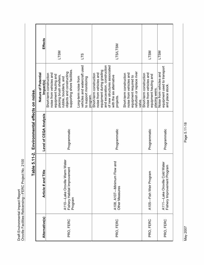
Dra
ft E
nviro
nmen
tal I
mpa
ct R
epor
t
Oro
ville
Fac
ilitie
s R
elic
ensi
ng—
FER
C P
roje
ct N
o. 2
100
May
200
7 P
age
5.11
-18
Tabl
e 5.
11-2
. En
viro
nmen
tal e
ffect
s on
noi
se.
Alte
rnat
ive(
s)A
rtic
le #
and
Titl
e Le
vel o
f CEQ
A A
naly
sis
Nat
ure
of P
oten
tial
Impa
ct(s
) Ef
fect
s
PR
O, F
ER
C
A11
0—La
ke O
rovi
lle W
arm
Wat
er
Fish
ery
Hab
itat I
mpr
ovem
ent
Pro
gram
Pro
gram
mat
ic
Sho
rt-te
rm c
onst
ruct
ion
nois
e fro
m v
ehic
les
and
equi
pmen
t hau
ling
and
plac
ing
brus
h sh
elte
rs,
rubb
le, b
ould
ers,
and
ob
ject
s an
d co
nstru
ctin
g su
ppor
ting
shor
e fa
cilit
ies.
Long
-term
noi
se fr
om
vehi
cles
and
wat
ercr
aft u
sed
to s
uppo
rt m
onito
ring
prog
ram
.
LTS
M
LTS
PR
O, F
ER
C
A10
8, A
107—
Min
imum
Flo
w a
nd
Oth
er M
easu
res
Pro
gram
mat
ic
Sho
rt-te
rm c
onst
ruct
ion
nois
e fro
m v
ehic
les
and
equi
pmen
t dur
ing
grad
ing
and
exca
vatio
n, c
onst
ruct
ion
of n
ew s
truct
ures
ass
ocia
ted
with
the
six
alte
rnat
ive
proj
ects
.
Sho
rt-te
rm c
onst
ruct
ion
nois
e fro
m v
ehic
les
and
equi
pmen
t req
uire
d to
re
furb
ish
or re
plac
e riv
er
valv
e.
LTS
/LTS
M
PR
O, F
ER
C
A10
5—Fi
sh W
eir P
rogr
am
Pro
gram
mat
ic
Sho
rt-te
rm c
onst
ruct
ion
nois
e fro
m v
ehic
les
and
equi
pmen
t hau
ling
and
plac
ing
wei
rs.
LTS
M
PR
O, F
ER
C
A11
1—La
ke O
rovi
lle C
old
Wat
er
Fish
ery
Impr
ovem
ent P
rogr
am
Pro
gram
mat
ic
Noi
se fr
om v
ehic
les
and
equi
pmen
t use
d to
tran
spor
t an
d pl
ace
stoc
k.
LTS
M

C
hapt
er 5
.0
E
nviro
nmen
tal I
mpa
cts
P
age
5.11
-19
May
200
7
Tabl
e 5.
11-2
. En
viro
nmen
tal e
ffect
s on
noi
se.
Alte
rnat
ive(
s)A
rtic
le #
and
Titl
e Le
vel o
f CEQ
A A
naly
sis
Nat
ure
of P
oten
tial
Impa
ct(s
) Ef
fect
s Lo
ng-te
rm n
oise
from
ve
hicl
es a
nd w
ater
craf
t use
d to
sup
port
mon
itorin
g pr
ogra
m.
LTS
PR
O, F
ER
C
A11
2—C
ompr
ehen
sive
Wat
er
Qua
lity
Mon
itorin
g P
rogr
am
Pro
gram
mat
ic
Long
-term
noi
se fr
om
vehi
cles
and
wat
ercr
aft u
sed
to s
uppo
rt m
onito
ring
prog
ram
.
LTS
PR
O, F
ER
C
A12
2—C
onst
ruct
ion
and
Rec
harg
e of
Bro
od P
onds
P
roje
ct
Sho
rt-te
rm c
onst
ruct
ion
nois
e fro
m v
ehic
les
and
equi
pmen
t dur
ing
grad
ing
and
cons
truct
ion
of b
erm
s.
LTS
M
PR
O
A12
7—R
ecre
atio
n M
anag
emen
t P
lan
Am
eric
ans
with
Dis
abilit
ies
Act
(A
DA
) com
plia
nce
at e
xist
ing
faci
litie
sTr
ails
R
oads
P
arki
ng
Cam
pgro
unds
D
ocks
and
Boa
t Ram
ps
Oth
er F
acili
ties
Pro
ject
Sho
rt-te
rm c
onst
ruct
ion
nois
e fro
m v
ehic
les
and
equi
pmen
t dur
ing
grad
ing
and
exca
vatio
n, c
onst
ruct
ion
of n
ew fa
cilit
ies.
Long
-term
incr
ease
in
ambi
ent n
oise
leve
ls a
t re
crea
tion
faci
litie
s.
LTS
M
LTS
FER
C
A12
7—S
A R
ecre
atio
n M
anag
emen
t P
lan
(RM
P) (R
evis
ed b
y FE
RC
sta
ff to
incl
ude
mod
ifica
tions
to tr
ails
de
velo
pmen
t/im
plem
enta
tion;
re
cons
truct
ion
of b
oat-i
n ca
mps
ites;
de
lay
of d
ay u
se a
rea
at F
orem
an
Cre
ek)
Pro
ject
Sho
rt-te
rm c
onst
ruct
ion
nois
e fro
m v
ehic
les
and
equi
pmen
t dur
ing
grad
ing
and
exca
vatio
n, c
onst
ruct
ion
of n
ew fa
cilit
ies.
LT
SM

Dra
ft E
nviro
nmen
tal I
mpa
ct R
epor
t
Oro
ville
Fac
ilitie
s R
elic
ensi
ng—
FER
C P
roje
ct N
o. 2
100
May
200
7 P
age
5.11
-20
Tabl
e 5.
11-2
. En
viro
nmen
tal e
ffect
s on
noi
se.
Alte
rnat
ive(
s)A
rtic
le #
and
Titl
e Le
vel o
f CEQ
A A
naly
sis
Nat
ure
of P
oten
tial
Impa
ct(s
) Ef
fect
s
PR
OB
102—
Fuel
Loa
d M
anag
emen
t Pla
n in
Oro
ville
Wild
life
Are
a (O
WA
) P
rogr
amm
atic
Sho
rt-te
rm c
onst
ruct
ion
nois
e fro
m e
quip
men
t use
d fo
r fue
l tre
atm
ent,
cons
truct
ion
of fi
re ro
ads,
fu
el b
reak
s.
LTS
M
PR
OB
107—
Rev
isio
n of
Spe
ed L
imit
Reg
ulat
ion
for T
herm
alito
Afte
rbay
P
roje
ct
Long
-term
noi
se fr
om
wat
ercr
aft.
LTS
Cod
ing:
B =
Act
ion
with
pot
entia
l to
resu
lt in
a b
enef
icia
l effe
ct; c
ould
invo
lve
shor
t-ter
m, l
ess-
than
-sig
nific
ant,
cons
truct
ion-
rela
ted
impa
cts
that
wou
ld b
e av
oide
d or
re
duce
d th
roug
h th
e us
e of
Bes
t Man
agem
ent P
ract
ices
(BM
Ps)
. See
App
endi
x D
.
LTS
= A
ctio
n th
at w
ould
resu
lt in
less
-than
-sig
nific
ant i
mpa
ct o
n re
sour
ce.
LTS
M =
Act
ion
that
wou
ld re
sult
in le
ss-th
an-s
igni
fican
t im
pact
on
reso
urce
follo
win
g m
itiga
tion.

Chapter 5.0 Environmental Impacts
Page 5.11-21 May 2007
Program-Level Impacts and Mitigation Measures
Continuation of operations, maintenance, and recreation activities, construction of new or improved facilities, and implementation of new programs involving the use of construction equipment and operations of additional vehicles and watercraft would result in noise generation. The proposed programs that may result in noise generation are listed in Table 5.11-2.
Impact 5.11.2-a: Expose people to noise levels exceeding established standards of the local general plan or noise ordinance, or of other agencies.
NO Under the No-Project Alternative, routine operations, maintenance, and recreational activities would continue. The noise levels resulting from these activities would not be anticipated to change from the existing conditions. There would be no impact.
PRO The Butte County General Plan Noise Element has no standards applicable to the proposed programs. Butte County has no noise ordinance. There are no established standards of known to be applicable to the proposed programs. Therefore, there would be no impact.
FERC Impacts associated with noise under the FERC Staff Alternative would be similar to those under the Proposed Project. The FERC Staff Alternative includes more robust monitoring of the Gravel Supplementation and Improvement Program (SA Article A102) and earlier implementation of the Riparian and Floodplain Improvement Program (SA Article A106). These impacts would be considered less-than-significant and no mitigation would be required.
Impact 5.11.2-b: Result in substantial temporary or periodic increase in ambient noise levels in the project vicinity above existing levels
NO Under the No-Project Alternative, routine operations, maintenance, and recreational activities would continue. The noise levels from these activities would not be anticipated to change noticeably from the existing conditions. There would be no impact.
PRO, FERC The programs listed in Table 5.11-2, with the exception of Water Quality Monitoring, would be anticipated to include projects that would include the use of construction equipment for creation of new facilities or improvement of existing facilities. As noted in the table, many of the programs include the transportation and placement of heavy materials, and some programs include elements that would require grading. During construction, the

Draft Environmental Impact Report Oroville Facilities Relicensing—FERC Project No. 2100
May 2007 Page 5.11-22
principal source of noise would be the operation of diesel engine– driven heavy construction equipment and trucks performing the above tasks. Table 5.11-3 shows typical noise levels for construction equipment types that would likely be used on projects developed from the programs listed in Table 5.11-2. It is seen that most equipment has a maximum noise level of 85 A-weighted decibels (dBA) measured at a distance of 50 feet from the piece of equipment, and an acoustic usage of 40 percent, which would result in an hourly average noise level of 81 dBA at 50 feet.
Assuming a hard terrain in an urban setting, developed area, or over water, the noise levels would be reduced over distance at a rate of 6 dBA per doubling of distance. For the typical piece of equipment described above, the maximum noise level would be 79 dBA at 100 feet, 75 dBA at 160 feet, and 65 dBA at 500 feet. With soft terrain, such as agricultural or undeveloped forest land, noise levels would be reduced at an approximate rate of 7.5 dBA per doubling of distance, and the maximum noise level from 1 piece of equipment would be 75 dBA at 125 feet, 65 dBA at 315 feet, and 60 dBA at 500 feet. Hourly average noise levels would be approximately 4 dBA less. With 2 pieces of equipment operating, noise levels would be increased by 3 dBA.
Ambient daytime noise levels in recreational and agricultural areas are typically 50–55 dBA except in areas of powerboat or off-road vehicle use, or near heavily traveled roads. Nighttime noise levels are approximately 10 dBA less than during the daytime. Thus, people within 500 feet of daytime construction work would be likely to experience a substantial increase in the ambient noise level, and there would be periods when normal conversation would be disturbed. If construction were performed at night, the change in nearby noise levels would be severe with a high probability of sleep disturbance.
During the daytime, construction is not an unexpected activity, and while noisy, the operation of 1 or a few pieces of would not be considered a significant impact unless the receptor is within 75 feet of the equipment. While nighttime construction is not a normal occurrence, there are no applicable ordinances prohibiting nighttime work. Nighttime construction noise, with the greater change in noise levels and greater sensitivity of people to noise at night, could be a significant impact at distances up to 1,000 feet or more.
In recreational areas, it is reasonable to assume that persons using the areas on weekdays understand the need for ongoing construction, but on weekends these persons have expectations of

Chapter 5.0 Environmental Impacts
Page 5.11-23 May 2007
a relatively quiet environment.
Based on the above facts and discussion, it is concluded that a the construction noise resulting from the programs listed in Table 5.11-2, if occurring during the daytime on weekdays and requiring the use of diesel engine–driven heavy equipment, would cause a substantial temporary increase in ambient noise levels to receptors within 75 feet of the work area, and the impact would be potentially significant. With implementation of mitigation measures 5.11.2-b1 and 5.11.2-b2 described below, this impact would be reduced to less-than-significant.
Further, construction noise resulting from the programs listed in Table 5.11-2, if occurring during the nighttime or on weekends and requiring the use of diesel engine–driven heavy equipment, would cause a substantial temporary increase in ambient noise levels to receptors within 1,000 feet of the work area, and the impact would be potentially significant. With implementation of mitigation measures 5.11.2-b1 and 5.11.2-b2 described below, this impact would be reduced to less-than-significant.
Table 5.11-3. Construction equipment noise levels.
Equipment Description
Lmax Noise Limit at 50 ft
(dBA) Acoustic Usage
Factor1
Backhoe 80 40% Compactor (ground) 80 20% Concrete Mixer Truck 85 40% Dozer 85 40% Dump Truck 84 40% Excavator 85 40% Front End Loader 80-85 40% Grader 85 40% Paver 85-89 50% Scraper 85-89 40% All other equipment > 5 hp 85 50% Notes: dBA = A-weighted decibels; hp = horsepower; Lmax = maximum noise level (the maximum instantaneous noise level during a specific period) 1 Represents the percent of time that equipment is assumed to be running at full
power while working on site.
Sources: Thalheimer 2000; FTA 2006
Mitigation measure 5.11.2-b1: Implement Noise Abatement Measures for Daytime Heavy Construction Close to Sensitive Receptors.
PRO, FERC If projects developed from the programs listed in Table 5.11-2 require the use of heavy construction equipment closer than 75 feet to residences, campgrounds, or similar recreation or noise-

Draft Environmental Impact Report Oroville Facilities Relicensing—FERC Project No. 2100
May 2007 Page 5.11-24
sensitive areas, the construction manager would either (a) arrange for all persons who would otherwise be within 75 feet of the work area to be moved to a farther distance or prevented from camping or recreating within the 75-foot limit, or, if not feasible, (b) erect temporary barriers of wood, noise abatement blankets, or similar material between the work area and the receptors. The barriers should be at least 8 feet high and solid from the ground to the top, and made of material that would reduce noise through the barrier (transmission loss) by at least 20 dBA. Plywood one-half inch thick would meet this requirement. This mitigation measure would provide protective measures to avoid a substantial temporary increase in ambient noise levels near sensitive receptors due to daytime construction activities. Consequently, this impact would be reduced to a less-than-significant level.
Mitigation measure 5.11.2-b2: Limit the Hours of Construction to Weekday Daytime Hours.
PRO, FERC The project applicant would require construction contractors to limit noise-generating construction activities to the hours of 7 a.m. to 8 p.m., Monday through Friday, with no noise-generating activities on Saturdays, Sundays, or legal holidays. However, this restriction would not be applicable if it would result in operational impacts on the Oroville Facilities or prevent activities to mitigate adverse conditions such as response to emergencies or other unforeseen situations. This measure does not prevent the accomplishment of work that does not generate unusual noise, such as inspections or surveying. This mitigation measure would provide protective measures to avoid a substantial temporary increase in ambient noise levels near sensitive receptors due to nighttime and weekend construction activities. Consequently, this impact would be reduced to a less-than-significant level.
Impact 5.11.2-c: Result in a permanent increase in ambient noise above existing levels.
NO Under the No-Project Alternative, routine operations, maintenance, and recreational activities would continue. The noise levels from these activities would not be anticipated to change noticeably from the existing conditions. There would be no impact.
PRO, FERC Table 5.11-2 shows the programs that would have a continuing potential for noise impacts. Each of these projects includes ongoing monitoring that would entail the use of light vehicles and watercraft. For some of the programs, the monitoring would likely be infrequent, such as once every 3 years or 5 years. Overall, the

Chapter 5.0 Environmental Impacts
Page 5.11-25 May 2007
additional noise generated from the few trips by the light vehicles and watercraft used in these programs would be less-than-significant.
The goals of most of the programs listed in Table 5.11-2 are to improve the aquatic habitat, and these programs would not generate a noticeable increase in use of the recreational facilities.It is presumed that the projects that improve recreation facilities and add campsites would induce more recreational visitors, and would increase the number of vehicle trips to and from the area.Provision of up to 15 new campsites at Loafer Creek could generate additional traffic, but the additional number of trips would be very small when compared with existing traffic. The impact to an increase in noise would be less-than-significant and no mitigation would be required.
Project-Level Impacts and Mitigation Measures
Continuation of operations, maintenance, and recreation activities, construction of new or improved facilities, and implementation of new projects involving the use of construction equipment and operation of additional vehicles and watercraft would result in the generation of noise. The proposed projects that may result in noise generation are listed in Table 5.11-2.
Impact 5.11.2-a: Expose people to noise levels exceeding established standards of the local general plan or noise ordinance, or of other agencies.
NO Under the No-Project Alternative, routine operations, maintenance, and recreational activities would continue. The noise environment would not be anticipated to change from the existing conditions.There would be no impact.
PRO, FERC The Butte County General Plan Noise Element has no standards applicable to the Proposed Project. Butte County has no adopted noise ordinance. There are no established standards of other agencies known to be applicable to the Proposed Project activities. Therefore, there would be no impact and no mitigation would be required.
Impact 5.11.2-b: Result in a substantial temporary or periodic increase in ambient noise levels in the project vicinity above existing levels.
NO Under the No-Project Alternative, routine operations, maintenance, and recreational activities would continue. The noise levels from these activities would not be anticipated to change noticeably from

Draft Environmental Impact Report Oroville Facilities Relicensing—FERC Project No. 2100
May 2007 Page 5.11-26
the existing conditions. There would be no impact.
PRO, FERC The projects listed in Table 5.11-2 would be anticipated to include the use of construction equipment for creation of new facilities or improvement of existing facilities. During construction, the principal source of noise would be the operation of diesel engine–driven heavy construction equipment and trucks performing the above tasks. Table 5.11-3 shows typical noise levels for construction equipment types that would likely be used. It is seen that most equipment has a maximum noise level of 85 dBA measured at a distance of 50 feet from the piece of equipment, and an acoustic usage of 40 percent, which would result in an hourly average noise level of 81 dBA at 50 feet.
Assuming a hard terrain in an urban setting, developed area, or over water, the noise levels would be reduced over distance at a rate of 6 dBA per doubling of distance. For the typical piece of equipment described above, the maximum noise level would be 79 dBA at 100 feet, 75 dBA at 160 feet, and 65 dBA at 500 feet. With soft terrain, such as agricultural or undeveloped forest land, noise levels would be reduced at an approximate rate of 7.5 dBA per doubling of distance, and the maximum noise level from 1 piece of equipment would be 75 dBA at 125 feet, 65 dBA at 315 feet, and 60 dBA at 500 feet. Hourly average noise levels would be approximately 4 dBA less than these levels. With 2 pieces of equipment operating, noise levels would be increased by 3 dBA.
Ambient daytime noise levels in recreational and agricultural areas are typically 50–55 dBA except in areas of powerboat or off-road vehicle use, or near heavily traveled roads. Nighttime noise levels are approximately 10 dBA less than during the daytime. Thus, people within 500 feet of daytime construction work would be likely to experience a substantial increase in the ambient noise level, and there would be periods when normal conversation would be disturbed. If construction were performed at night, the change in nearby noise levels would be severe with a high probability of sleep disturbance.
During the daytime, construction is not an unexpected activity, and while noisy, the operation of 1 or a few pieces of equipment would not be considered a significant impact unless the receptor is within 75 feet of the equipment. While nighttime construction is not a normal occurrence, there are no applicable ordinances prohibiting nighttime work. Nighttime construction noise, with the greater change in noise levels and greater sensitivity of people to noise at night, could be a significant impact at distances up to 1,000 feet or more.

Chapter 5.0 Environmental Impacts
Page 5.11-27 May 2007
In recreational areas, it is reasonable to assume that persons using the areas on weekdays understand the need for ongoing construction, but on weekends these persons have higher expectations of a relatively quiet environment.
Based on the above facts and discussion, it is concluded that a the construction noise resulting from the projects listed in Table 5.11-2, if occurring during the daytime on weekdays and requiring the use of diesel–engine driven heavy equipment, would cause a substantial temporary increase in ambient noise levels toreceptors within 75 feet of the work area, and the impact would be potentially significant. With implementation of mitigation measures 5.11.2-b1 and 5.11.2-b2 described below, this impact would be reduced to less-than-significant.
Further, construction noise resulting from the programs listed in Table 5.11-2, if occurring during the nighttime or on weekends and requiring the use of diesel engine–driven heavy equipment, would cause a substantial temporary increase in ambient noise levels to receptors within 1,000 feet of the work area, and the impact would be potentially significant. With implementation of mitigation measures 5.11.2-b1 and 5.11.2-b2 described below, this impact would be reduced to less-than-significant.
Mitigation measure 5.11.2-b1: Implement Noise Abatement Measures for Daytime Heavy Construction Close to Sensitive Receptors.
PRO, FERC If projects listed in Table 5.11-2 require the use of heavy construction equipment closer than 75 feet to residences, campgrounds, or similar recreation or noise-sensitive areas, the construction manager would either (a) arrange for all persons who would otherwise be within 75 feet of the work area to be moved to a farther distance or prevented from camping or recreating within the 75-foot limit, or, if not feasible, (b) erect temporary barriers of wood, noise abatement blankets, or similar material between the work area and the receptors. The barriers should be at least 8 feet high and solid from the ground to the top, and made of material that would reduce noise through the barrier (transmission loss) by at least 20 dBA. Plywood one-half inch thick would meet this requirement. This mitigation measure would provide protective measures to avoid a substantial temporary increase in ambient noise levels near sensitive receptors due to daytime construction activities. Consequently, this impact would be reduced to a less-than-significant level.

Draft Environmental Impact Report Oroville Facilities Relicensing—FERC Project No. 2100
May 2007 Page 5.11-28
Mitigation measure 5.11.2-b2: Limit the Hours of Construction to Weekday Daytime Hours.
PRO, FERC The project applicant would require construction contractors to limit noise-generating construction activities to the hours of 7 a.m. to 8 p.m., Monday through Friday, with no noise-generating activities on Saturdays, Sundays, or legal holidays. This measure does not prevent the accomplishment of work that does not generate unusual noise, such as inspections or surveying. This mitigation measure would provide protective measures to avoid a substantial temporary increase in ambient noise levels near sensitive receptors due to nighttime and weekend construction activities. Consequently, this impact would be reduced to a less-than-significant level.
Impact 5.11.2-c: Result in a permanent increase in ambient noise above existing levels.
NO Under the No-Project Alternative, routine operations, maintenance, and recreational activities would continue. The long-term ambient noise levels would not be anticipated to change noticeably from the existing conditions. There would be no impact from these activities.
PRO, FERC Table 5.11-2 shows the projects that would have a continuing potential for noise impacts. Each of these projects, except the revision of the speed limit for Thermalito Afterbay, includes ongoing monitoring that would entail the use of light vehicles and watercraft.For some of the programs, the monitoring would be infrequent, such as once every 3 years or 5 years. Overall, the noise generation from the occasional vehicle use would be less-than-significant.
Revision of the speed limit for Thermalito Afterbay (SA Section B107) would include allowing higher legal speeds on the portion of the afterbay south of SR 162, and improving enforcement of the 5 mph speed limit on the remainder of the afterbay. Since current boat operation occurs at higher speeds already, the Proposed Project is not expected to increase ambient noise levels. Nearly all of the land use adjacent to the afterbay south of SR 162 is agricultural. On the west, there are some residences, and the dominant noise to these homes is traffic noise from SR 99, which is between the afterbay and the homes. Scattered residences to the south are further from SR 99, and are closer to another noise source, the Oroville Municipal Airport. At the few residences near the afterbay, the noise increase from boat operations would likely be heard on occasion. However, with the small number of residences and the existing noise environment, the increase would

Chapter 5.0 Environmental Impacts
Page 5.11-29 May 2007
be less-than-significant.
In addition to the projects listed in Table 5.11-2, it is presumed that the projects that improve recreation facilities and add campsites would induce more recreational visitors, and would increase the number of vehicle trips to and from the area. While the number of additional visitors has not been calculated, it was assumed that the improved and additional facilities could add an average of 500 trips per day. These trips would be divided among the various roadways used for access to the recreation areas. Average daily traffic (ADT) volumes on SR 70, SR 99, and SR 162 in the local area range from 1,850 to more than 10,000 ADT, with the lowest volume of 1,850 occurring on SR 162 between Forbestown Road and Loafer Creek Campground (Caltrans Website). If 500 ADT were added to this segment, the traffic noise increase would be 1 dBA, which would be imperceptible. If 500 ADT were added to segments with greater volumes than 1,850, the traffic noise increase would be less than 1 dBA. The impact would be less-than-significant and no mitigation would be required.

Draft Environmental Impact Report Oroville Facilities Relicensing—FERC Project No. 2100
May 2007 Page 5.11-30
This page intentionally left blank.

Chapter 5.0 Environmental Impacts
Page 5.12-1 May 2007
5.12 AIR QUALITY
5.12.1 Regulatory Setting
5.12.1.1 Federal Plans, Policies, Regulations, and Laws
At the federal level, the U.S. Environmental Protection Agency (USEPA) has been charged with implementing national air quality programs. USEPA’s air quality mandates are drawn primarily from the federal Clean Air Act (CAA), which was enacted in 1970.The most recent major amendments made by Congress were in 1990.
The CAA required USEPA to establish national ambient air quality standards (NAAQS). As shown in Table 4.12-1 in Section 4.12, USEPA has established primary and secondary NAAQS for the following criteria air pollutants: ozone, carbon monoxide (CO), nitrogen dioxide (NO2), sulfur dioxide (SO2), respirable particulate matter (PM10), fine particulate matter (PM2.5), and lead. The primary standards protect the public health and the secondary standards protect public welfare. The CAA also required each state to prepare an air quality control plan referred to as a State Implementation Plan (SIP). The SIP is periodically modified to reflect the latest emissions inventories, planning documents, and rules and regulations of the air basins as reported by their jurisdictional agencies. If USEPA determines a SIP to be inadequate, a Federal Implementation Plan (FIP) may be prepared for the nonattainment area that could impose additional control measures.
Federal Hazardous Air Pollutant Programs
USEPA has programs for identifying and regulating Toxic Air Contaminants (TACs), or in federal parlance hazardous air pollutants (HAPs). The emissions standards are promulgated in two phases. HAP statutes and regulations generally require the use of the maximum or best available control technology for toxics (MACT and BACT) to limit emissions. In the first phase (1992–2000), USEPA developed technology-based emission standards designed to produce the maximum emission reduction achievable. In the second phase (2001–2008), USEPA is required to promulgate health risk–based emissions standards where deemed necessary to address risks remaining after implementation of the technology-based standards.
The CAA also required USEPA to promulgate vehicle or fuel standards containing reasonable requirements that control toxic emissions, at a minimum to benzene and formaldehyde. Performance criteria were established to limit mobile-source emissions of toxics, including benzene, formaldehyde, and 1,3-butadiene. In addition, Section 219 required the use of reformulated gasoline in selected areas with the most severe ozone nonattainment conditions to further reduce mobile-source emissions.
5.12.1.2 State Plans, Policies, Regulations, and Laws
The California Air Resources Board (ARB) is the agency responsible for coordination and oversight of State and local air pollution control programs in California and for

Draft Environmental Impact Report Oroville Facilities Relicensing—FERC Project No. 2100
May 2007 Page 5.12-2
implementing the California Clean Air Act (CCAA) (1988). The CCAA, which was adopted in 1988, required ARB to establish California ambient air quality standards (Table 4.12-1). In most cases the California standards are more stringent than national standards. The California standards incorporate a margin of safety to protect sensitive individuals. The CCAA specifies that local air districts should focus particular attention on reducing the emissions from transportation and area-wide emission sources, and provides districts with the authority to regulate indirect sources.
Other ARB responsibilities include, but are not limited to, overseeing local air district compliance with California and federal laws, approving local air quality plans, submitting SIPs to USEPA, monitoring air quality, determining and updating area designations and maps, and setting emissions standards for new mobile sources, consumer products, small utility engines, off-road vehicles, and fuels.
State Toxic Air Contaminant Programs
In California, TACs are primarily regulated through the Tanner Air Toxics Act and the Air Toxics Hot Spots Information and Assessment Act of 1987. Through these laws, ARB can designate substances as TACs. To date, ARB has identified over 21 TACs, and adopted USEPA’s list of HAPs as TACs. Once a TAC is identified, ARB then adopts an Airborne Toxics Control Measure for sources that emit that particular TAC. If there is a safe threshold for a substance at which there is no toxic effect, the control measure must reduce exposure below that threshold. If there is no safe threshold, the measure must incorporate BACT to minimize emissions. Most recently, diesel particulate matter (PM) was added to the ARB list of TACs.
ARB has adopted diesel exhaust control measures and more stringent emission standards for various on-road mobile sources of emissions, including transit buses, and off-road diesel equipment (e.g., tractors, generators). Future control measures include the low-sulfur diesel fuel requirement, and tighter emission standards for heavy-duty diesel trucks (2007) and off-road diesel equipment (2011) nationwide.
ARB recently published the Air Quality and Land Use Handbook: A Community Health Perspective, which provides guidance concerning land use compatibility with TAC sources (ARB 2005). While not a law or adopted policy, the handbook offers advisory recommendations for the siting of sensitive receptors near uses associated with TACs such as freeways and high-traffic roads, commercial distribution centers, rail yards, ports, refineries, dry cleaners, gasoline stations, and industrial facilities to help keep children and other sensitive populations out of harm’s way.
State regulations on asbestos are related to demolition and renovations, and waste deposal of asbestos-containing materials. California also has a statewide regulation covering naturally occurring asbestos (NOA). The Asbestos ATCM for Asbestos-Containing Serpentine, adopted in 1990, prohibited the use of serpentine aggregate for surfacing if the asbestos content was 5% or more, which was lowered to 0.25% in 2000 and modified to include ultramafic rock.

Chapter 5.0 Environmental Impacts
Page 5.12-3 May 2007
In July 2001, ARB adopted an ATCM for construction, grading, quarrying, and surface mining operations that regulates grading and excavation activities in areas of serpentine or ultramafic rocks. In addition, the Governor’s Office of Planning and Research issued a memorandum providing guidance to lead agencies in analyzing the impacts of NOA through the CEQA review process.
Executive Order S-3-05
On June 1, 2005, Governor Arnold Schwarzenegger issued Executive Order S-3-05 establishing greenhouse gas (GHG) emission targets for California and requiring biennial reports on potential climate change effects on several areas, including water resources. A Climate Action Team (CAT) was established by the governor to lead the reporting efforts. The order established the following goals for reducing GHG emissions in the state:
By 2010, reduce emissions to the 2000 level.
By 2020, reduce emissions to the 1990 level.
By 2050, reduce emissions to 80 percent below 1990 emissions.
The Executive Order identifies the agencies involved and coordination expected:
The Secretary of the California Environmental Protection Agency shall coordinate oversight of the efforts to meet the targets with: the Secretary of the Business, Transportation and Housing Agency, Secretary of the Department of Food and Agriculture, Secretary of the Resources Agency, Chairperson of the Air Resources Board, Chairperson of the Energy Commission, and the President of the Public Utilities Commission.
Due to the low GHG emissions from California reservoirs relative to replacement power sources, it is anticipated that under future implementation of the Renewable Portfolio Standards, hydroelectric generation will play a role in meeting these statewide reduction targets by replacing power produced by higher GHG-emitting thermal power sources. (Renewables Portfolio Standard (RPS) Eligibility Guidebook, publication #CEC-300-2006-007-F, adopted April 26, 2006 [CEC Website].)
Assembly Bill 32
In 2006, the California Legislature passed Assembly Bill 32 (also known as the Global Warming Solutions Act of 2006), which establishes a State goal of reducing GHG emissions to 1990 levels by 2020. The bill requires ARB to adopt regulations and develop an enforcement mechanism to ensure compliance. ARB is currently developing policy for GHG reductions in the state.

Draft Environmental Impact Report Oroville Facilities Relicensing—FERC Project No. 2100
May 2007 Page 5.12-4
5.12.1.3 Local Plans, Policies, Regulations, and Laws
Butte County Air Quality Management District
Butte County Air Quality Management District (BCAQMD) is the primary local agency responsible for protecting the people and the environment of Butte County from the effects of air pollution. BCAQMD is responsible for adopting rules that limit pollution, issuing permits to ensure compliance, and inspecting pollution sources. BCAQMD also monitors air quality in the county and prepares plans to demonstrate how compliance with state and federal standards would be attained and maintained.
Air Quality Plans
Federal and State air quality laws also require regions designated as nonattainment to prepare plans that demonstrate how the region will attain the pollutant standard. Air quality planning in the Northern Sacramento Valley Air Basin has been undertaken on a joint basis by the air districts in seven counties, including Butte County. The current plan, the 2003 Air Quality Attainment Plan (2003 AQAP), is an update of plans prepared in 1994, 1997, and 2000. The purpose of the plan is to achieve and maintain healthful air quality throughout the air basin. The 2003 AQAP addresses the progress made in implementing the 2000 plan and proposes modifications to the strategies necessary to attain the California ambient air quality standard for the 1-hour ozone standard at the earliest practicable date. BCAQMD has current air quality plans for ozone and PM10.
Butte County
There is no air quality element in the existing Butte County General Plan. Butte County (County) is in the process of updating its general plan and has produced technical background reports, including one for air quality. This implies that there could be an air quality element when the updated general plan is adopted by the County.
5.12.2 Impact Thresholds
The following thresholds are used to determine whether the alternatives would have a significant effect on air quality. There would be a significant impact if the alternatives would:
5.12-a: Violate any air quality standard or contribute substantially to an existing or projected air quality violation;
5.12-b: Conflict with or obstruct implementation of an applicable air quality plan;
5.12-c: Expose sensitive receptors to substantial pollutant concentrations;
5.12-d: Create objectionable odors affecting a substantial number of people; or

Chapter 5.0 Environmental Impacts
Page 5.12-5 May 2007
5.12-e: Result in a cumulatively considerable net increase of any criteria pollutant for which the Project region of influence is nonattainment under an applicable federal or State ambient air quality standard.
BCAQMD does not have quantitative thresholds. There are currently no regulatory standards for GHG emissions or other scientific data to help define what could constitute a significant impact.
5.12.3 Method of Analysis
5.12.3.1 Quantitative Thresholds
Quantitative thresholds were developed from the USEPA General Conformity Rule governing federal actions. The most recent thresholds were published in the Federal Register on July 17, 2006.
5.12.3.2 Program-Level Analysis
Program-level actions indicate that all of the actions except one would require the use of construction equipment. Based on the review of both the program-level and project-level descriptions, an “example” project was developed. This example would be a 12-month project that includes grading with 3 pieces of heavy equipment working concurrently, followed by construction with 3 pieces of heavy equipment, followed by painting and asphalt paving. The emissions of this “example” were quantified using the URBEMIS 2002 software package, version 8.7 (ARB 2005). URBEMIS is a calculation tool designed to estimate air emissions from land use development and the model contains data that are specific for each California air basin. Although programs might occur over 10 years or more, emission factors for 2008 were used, which is a conservative assumption because emission factors would decrease in later years with the continuing improvement in emission reduction technology for diesel engines.
Post-construction emissions at the program level were not quantified because a review of the programs indicated that the post-construction activities would be minimal. Potential mitigation measures were developed to be consistent with the Rules of the BCAQMD and accepted emission control methods.
The GHG emissions from the Oroville Facilities when compared to Existing Conditions are expected to either remain unchanged or decrease with age of the reservoir under any of the alternatives. No actions in any of the alternatives analyzed would result in a significant increase in GHG emissions from the Oroville Facilities and therefore, there are no impacts.
5.12.3.3 Project-Level Analysis
Although actions are more specifically described at the project level, the detail is not specific enough to assess individual projects quantitatively. For construction impacts, the “example” project analysis developed for the program-level analysis was also used

Draft Environmental Impact Report Oroville Facilities Relicensing—FERC Project No. 2100
May 2007 Page 5.12-6
at the project level. Post-construction emissions associated with some of the actions would be negligible.
5.12.4 Impacts and Mitigation Measures
The following section describes the effects of the No-Project, Proposed Project, and the FERC Staff Alternative. Impacts on air quality from implementing the FERC Staff Alternative are similar to those anticipated from implementation of the Proposed Project.Potential impacts are identified as follows: NO (No-Project), PRO (Proposed Project), and FERC (FERC Staff Alternative). Table 5.12-1 indicates the SA articles or actions that could have an effect on air quality and whether these effects are expected to be beneficial, less-than-significant, or would be less-than-significant following implementation of recommended mitigation measures. All alternatives analyzed result in less-than-significant impacts on air quality with the implementation of best management practices (BMPs) included in both the Proposed Project and the FERC Staff Alternative and as described in Appendix D, and mitigation measures described below to address short-term, construction-related impacts.
5.12.4.1 Program-Level Impacts and Mitigation Measures
Continuation of operations, maintenance, and recreation activities, construction of new or improved facilities, implementation of new programs involving ground disturbance, and the use of construction equipment and operations of additional vehicles and watercraft would result in the emission of air pollutants. The proposed programs that may result in the emission of air pollutants are listed in Table 5.12-1.
Impact 5.12-a: Violate any air quality standard or contribute substantially to an existing or projected air quality violation.
NO Under the No-Project Alternative, routine operations, maintenance, and recreational activities would continue. Emissions of gaseous and particulate pollutants, including GHGs, would not be anticipated to change noticeably from Existing Conditions. There would be no impact from these activities.
PRO BCAQMD does not have quantitative thresholds to define CEQA significance or substantial quantities of emissions. Guidance may be taken from the USEPA General Conformity Rule governing federal actions, which has de minimis levels of 100 tons per year for oxides of nitrogen (NOX), reactive organic gases (ROG), PM10,and PM2.5 in areas where the air quality is better than “serious,” which is the case for Butte County (Federal Register, July 17, 2006; 40 Code of Federal Regulations [CFR] Parts 51 and 93).Projects with emissions less than these de minimis thresholds are presumed to conform with plans for attaining and maintaining ambient air quality standards, and therefore would not have a

C
hapt
er 5
.0
E
nviro
nmen
tal I
mpa
cts
P
age
5.12
-7
May
200
7
Tabl
e 5.
12-1
. En
viro
nmen
tal e
ffect
s on
air
qual
ity.
Alte
rnat
ive(
s)
Art
icle
# a
nd T
itle
Leve
l of C
EQA
Ana
lysi
s N
atur
e of
Pot
entia
l Im
pact
(s)
Effe
cts
PR
OA
102—
Gra
vel S
uppl
emen
tatio
n an
d Im
prov
emen
t Pro
gram
P
rogr
amm
atic
with
som
e P
roje
ct e
lem
ents
Sho
rt-te
rm p
ollu
tant
em
issi
ons
from
veh
icle
s an
d eq
uipm
ent h
aulin
g an
d pl
acin
g gr
avel
LTS
M
FER
CA
102—
Gra
vel S
uppl
emen
tatio
n an
d Im
prov
emen
t Pro
gram
P
rogr
amm
atic
with
som
e P
roje
ct e
lem
ents
Sho
rt-te
rm p
ollu
tant
em
issi
ons
from
veh
icle
s an
d eq
uipm
ent h
aulin
g an
d pl
acin
g gr
avel
LTS
M
PR
O, F
ER
C
A10
3—C
hann
el Im
prov
emen
t P
rogr
am (T
his
actio
n is
pr
ogra
mm
atic
; how
ever
, Moe
’s a
nd
Hat
cher
y D
itch
activ
ities
are
pro
ject
-le
vel)
Pro
gram
mat
ic w
ith s
ome
Pro
ject
ele
men
ts
Sho
rt-te
rm p
ollu
tant
em
issi
ons
from
veh
icle
s an
d eq
uipm
ent d
urin
g gr
adin
g an
d ex
cava
tion
Long
-term
pol
luta
nt
emis
sion
s fro
m v
ehic
les
used
to s
uppo
rt m
onito
ring
prog
ram
LTS
M
LTS
PR
O, F
ER
C
A10
4—S
truct
ural
Hab
itat
Sup
plem
enta
tion
and
Impr
ovem
ent
Pro
gram
(SH
SI)
P
rogr
amm
atic
Sho
rt-te
rm p
ollu
tant
em
issi
ons
from
veh
icle
s an
d eq
uipm
ent h
aulin
g an
d pl
acin
g w
oody
deb
ris,
boul
ders
, and
oth
er n
ativ
e ob
ject
s
LTS
M
PR
OA
106—
Rip
aria
n an
d Fl
oodp
lain
Im
prov
emen
t Pro
gram
P
rogr
amm
atic
Sho
rt-te
rm p
ollu
tant
em
issi
ons
from
veh
icle
s an
d eq
uipm
ent d
urin
g co
nstru
ctio
n
LTS
M

Dra
ft E
nviro
nmen
tal I
mpa
ct R
epor
t O
rovi
lle F
acilit
ies
Rel
icen
sing
—FE
RC
Pro
ject
No.
210
0
May
200
7 P
age
5.12
-8
Tabl
e 5.
12-1
. En
viro
nmen
tal e
ffect
s on
air
qual
ity.
Alte
rnat
ive(
s)
Art
icle
# a
nd T
itle
Leve
l of C
EQA
Ana
lysi
s N
atur
e of
Pot
entia
l Im
pact
(s)
Effe
cts
FER
C
A10
6—R
ipar
ian
and
Floo
dpla
in
Impr
ovem
ent P
rogr
am (a
s re
vise
d by
FE
RC
sta
ff to
acc
eler
ate
sche
dule
)
Pro
gram
mat
ic
Sho
rt-te
rm p
ollu
tant
em
issi
ons
from
veh
icle
s an
d eq
uipm
ent d
urin
g co
nstru
ctio
n
LTS
M
PR
O, F
ER
C
A11
0—La
ke O
rovi
lle W
arm
Wat
er
Fish
ery
Hab
itat I
mpr
ovem
ent
Pro
gram
Pro
gram
mat
ic
Sho
rt-te
rm p
ollu
tant
em
issi
ons
from
veh
icle
s an
d eq
uipm
ent h
aulin
g an
d pl
acin
g br
ush
shel
ters
, ru
bble
, bou
lder
s, a
nd
obje
cts
and
cons
truct
ing
supp
ortin
g sh
ore
faci
litie
s
Long
-term
pol
luta
nt
emis
sion
s fro
m v
ehic
les
and
wat
ercr
aft u
sed
to s
uppo
rt m
onito
ring
prog
ram
LTS
M
LTS
PR
O, F
ER
C
A10
8, A
107—
Min
imum
Flo
w a
nd
Oth
er M
easu
res
Pro
gram
mat
ic
Sho
rt-te
rm c
onst
ruct
ion
pollu
tant
em
issi
ons
from
ve
hicl
es a
nd e
quip
men
t du
ring
grad
ing
and
exca
vatio
n, c
onst
ruct
ion
of
new
stru
ctur
es a
ssoc
iate
d w
ith th
e si
x al
tern
ativ
e pr
ojec
ts
Sho
rt-te
rm c
onst
ruct
ion
pollu
tant
em
issi
ons
from
ve
hicl
es a
nd e
quip
men
t re
quire
d to
refu
rbis
h or
re
plac
e riv
er v
alve
LTS

C
hapt
er 5
.0
E
nviro
nmen
tal I
mpa
cts
P
age
5.12
-9
May
200
7
Tabl
e 5.
12-1
. En
viro
nmen
tal e
ffect
s on
air
qual
ity.
Alte
rnat
ive(
s)
Art
icle
# a
nd T
itle
Leve
l of C
EQA
Ana
lysi
s N
atur
e of
Pot
entia
l Im
pact
(s)
Effe
cts
PR
O, F
ER
C
A10
5—Fi
sh W
eir P
rogr
am
Pro
gram
mat
ic
Sho
rt-te
rm p
ollu
tant
em
issi
ons
from
veh
icle
s an
d eq
uipm
ent h
aulin
g an
d pl
acin
g w
eirs
LTS
M
PR
O, F
ER
C
A11
1—La
ke O
rovi
lle C
old
Wat
er
Fish
ery
Impr
ovem
ent P
rogr
am
Pro
gram
mat
ic
Sho
rt-te
rm p
ollu
tant
em
issi
ons
from
veh
icle
s an
d eq
uipm
ent u
sed
to tr
ansp
ort
and
plac
e st
ock
Long
-term
pol
luta
nt
emis
sion
s fro
m v
ehic
les
and
wat
ercr
aft u
sed
to s
uppo
rt m
onito
ring
prog
ram
LTS
LTS
PR
O, F
ER
C
A11
2—C
ompr
ehen
sive
Wat
er
Qua
lity
Mon
itorin
g P
rogr
am
Pro
gram
mat
ic
Long
-term
pol
luta
nt
emis
sion
s fro
m v
ehic
les
and
wat
ercr
aft u
sed
to s
uppo
rt m
onito
ring
prog
ram
LTS
PR
O, F
ER
C
A12
2—C
onst
ruct
ion
and
Rec
harg
e of
Bro
od P
onds
P
roje
ct
Sho
rt-te
rm p
ollu
tant
em
issi
ons
from
veh
icle
s an
d eq
uipm
ent d
urin
g gr
adin
g an
d co
nstru
ctio
n of
ber
ms
LTS
M
PR
O
A12
7—R
ecre
atio
n M
anag
emen
t P
lan A
DA
com
plia
nce
at e
xist
ing
faci
litie
sTr
ails
R
oads
P
arki
ng
Cam
pgro
unds
D
ocks
and
Boa
t Ram
ps
Oth
er F
acili
ties
Pro
ject
Sho
rt-te
rm p
ollu
tant
em
issi
ons
from
veh
icle
s an
d eq
uipm
ent d
urin
g gr
adin
g an
d ex
cava
tion,
con
stru
ctio
n of
new
faci
litie
s
Long
-term
pol
luta
nt
emis
sion
s fro
m v
ehic
les
and
wat
ercr
aft f
rom
use
of
recr
eatio
n fa
cilit
ies
LTS
M
LTS

Dra
ft E
nviro
nmen
tal I
mpa
ct R
epor
t O
rovi
lle F
acilit
ies
Rel
icen
sing
—FE
RC
Pro
ject
No.
210
0
May
200
7 P
age
5.12
-10
Tabl
e 5.
12-1
. En
viro
nmen
tal e
ffect
s on
air
qual
ity.
Alte
rnat
ive(
s)
Art
icle
# a
nd T
itle
Leve
l of C
EQA
Ana
lysi
s N
atur
e of
Pot
entia
l Im
pact
(s)
Effe
cts
FER
C
A12
7—M
odifi
ed R
ecre
atio
n M
anag
emen
t Pla
n S
ame
as A
127
with
: R
econ
stru
ct b
oat-i
n ca
mpg
roun
ds
Pro
ject
Sho
rt-te
rm p
ollu
tant
em
issi
ons
nois
e fro
m
vehi
cles
and
equ
ipm
ent
durin
g gr
adin
g an
d ex
cava
tion,
con
stru
ctio
n of
ne
w fa
cilit
ies
LTS
M
PR
OB
107—
Rev
isio
n of
Spe
ed L
imit
Reg
ulat
ion
for T
herm
alito
Afte
rbay
P
roje
ct
Long
-term
pol
luta
nt
emis
sion
from
wat
ercr
aft
LTS
Cod
ing:
B =
Act
ion
with
pot
entia
l to
resu
lt in
a b
enef
icia
l effe
ct; c
ould
invo
lve
shor
t-ter
m, l
ess-
than
-sig
nific
ant,
cons
truct
ion-
rela
ted
impa
cts
that
wou
ld b
e av
oide
d or
re
duce
d th
roug
h th
e us
e of
Bes
t Man
agem
ent P
ract
ices
(BM
Ps)
. See
App
endi
x D
.
LTS
= A
ctio
n th
at w
ould
resu
lt in
less
-than
-sig
nific
ant i
mpa
ct o
n re
sour
ce.
LTS
M =
Act
ion
that
wou
ld re
sult
in le
ss-th
an-s
igni
fican
t im
pact
on
reso
urce
follo
win
g m
itiga
tion.

Chapter 5.0 Environmental Impacts
Page 5.12-11 May 2007
significant impact. No increases in GHG emissions are expected from the Proposed Project; therefore, there would be no impactfrom these activities.
Short-Term Construction
The programs listed in Table 5.12-1, with the exception of Water Quality Monitoring, would be anticipated to include projects that would include the use of construction equipment for creation of new facilities or improvement of existing facilities. With respect to air quality standards, the principal pollutant of concern from construction equipment engine exhaust is NOX. Engine exhaust also includes ROG, PM10, PM2.5, and other pollutants. Grading and other ground disturbance activities produce particulates, PM10,and PM2.5. Painting and paving emit ROG.
While specific projects are not defined for some of the programs listed in Table 5.12-1, emissions were calculated for an “example” 12-month project that includes grading with 3 pieces of heavy equipment working concurrently, followed by construction with 3 pieces of heavy equipment, followed by painting and asphalt paving. NOX emissions for this “sample” project would be less than 5 tons per year; ROG emissions would be less than 1 ton per year; PM10 emissions would be less than 2 tons per year. Some of the projects implied by the programs listed in Table 5.12-1 would be of the order of magnitude of the “sample” project described above; many would be of lesser magnitude; some projects could be more intense. (Typical projects are discussed further in Section 5.12.4.2 below.) The projects included in the programs would not all occur in the same year. As the emissions of the “sample” project are less than 5 percent of the de minimis thresholds, it is concluded that the air quality impacts of the programs listed in Table 5.12-1 would be less-than-significant.
One program, the Fuel Load Management Program, would have the potential to violate an air quality standard. Fuel management programs may include prescribed burning. Smoke from fires can be a source of high concentrations of particulates, including PM10and PM2.5. If the fuel management projects were limited to mechanical treatment for fuel removal, the sources of emissions would be construction equipment and ground disturbance, and air quality impacts would be less-than-significant, as described above. If the projects include prescribed burns, the impact would be potentially significant. With implementation of mitigation measure 5.12-a, this impact would be reduced to less-than- significant.

Draft Environmental Impact Report Oroville Facilities Relicensing—FERC Project No. 2100
May 2007 Page 5.12-12
Long-term Operations
Table 5.12-1 shows the programs that would have a continuing potential for air quality impacts. Each of these programs includes ongoing monitoring that would entail the use of light vehicles and watercraft. For some of the programs, the monitoring would likely be infrequent, such as once every 3 years or 5 years. Overall, the emissions from light vehicles and watercraft used in these programs would be very small and less-than-significant.
The goals of most of the programs listed in Table 5.12-1 are to improve the aquatic habitat, and these programs would not generate a noticeable increase in use of the recreational facilities.It is presumed that the projects that improve recreation facilities and add campsites would induce more recreational visitors, and would increase the number of vehicle trips to and from the area.Provision of up to 15 new campsites at Loafer Creek could generate additional traffic, but the additional number of trips would be very small when compared with existing traffic. Therefore, the impact would be less-than-significant.
FERC Impacts on air resources under the FERC Staff Alternative would be similar to those under the Proposed Project. The FERC Staff Alternative includes more robust monitoring of the Gravel Supplementation and Improvement Program (SA Article A102) and earlier implementation of the Riparian and Floodplain Improvement Program (SA Article A106). These impacts would be considered less-than-significant.
Mitigation measure 5.12-a: Conduct Prescribed Burns in Accordance with the Rules of BCAQMD.
PRO, FERC If projects developed under the Fuel Load Management Program include prescribed burns, the burns would be planned and coordinated with the BCAQMD in accordance with their Rule 309—Wildland Vegetation Management Burning. All prescribed burns would be approved by BCAQMD prior to execution. This mitigation measure would ensure that prescribed burns would be designed and conducted to avoid significant PM10 and PM2.5concentrations. Consequently, the impact would be less-than-significant.

Chapter 5.0 Environmental Impacts
Page 5.12-13 May 2007
Impact 5.12-b: Conflict with or obstruct implementation of an applicable air quality plan.
NO Under the No-Project Alternative, routine operations, maintenance, and recreational activities would continue. Emissions of gaseous and particulate pollutants, including GHGs, would not be anticipated to change noticeably from Existing Conditions. There would be no impact from these activities.
PRO, FERC Air quality planning in the Northern Sacramento Valley Air Basin (NSVAB) has been undertaken on a joint basis by the air districts in seven counties, including Butte County. The current plan, the 2003 AQAP, is an update of plans prepared in 1994, 1997, and 2000. The purpose of the plan is to achieve and maintain healthful air quality throughout the air basin. The 2003 AQAP addresses the progress made in implementing the 2000 plan and proposes modifications to the strategies necessary to attain the California ambient air quality standard for the 1-hour ozone standard at the earliest practicable date.
As described in the Impact 5.12-a discussion, actions that are anticipated to emit pollutants at a rate less than the General Conformity Rule de minimis levels are presumed to conform with attainment plans. The proposed programs of Table 5.12-1 would have annual emissions of the ozone precursors, NOX and ROG, less than these de minimis thresholds. Therefore, there would be no conflict with the 2003 AQAP, no impact and no mitigation would be required.
Mitigation measure 5.12-b: No mitigation is required.
Impact 5.12-c: Expose sensitive receptors to substantial pollutant concentrations.
NO Under the No-Project Alternative, routine operations, maintenance, and recreational activities would continue. Emissions of gaseous and particulate pollutants would not be anticipated to change noticeably from Existing Conditions. Some of these activities may expose residents or persons involved in recreational activities to pollutants, such as dust and the exhaust from watercraft engines and maintenance vehicles and equipment. The quantity of pollutants would not be substantial and the impact would be less-than-significant.
PRO Each of the proposed programs of Table 5.12-1, with the exception of the Lake Oroville Cold Water Fishery Improvement and Comprehensive Water Quality Monitoring Programs, could

Draft Environmental Impact Report Oroville Facilities Relicensing—FERC Project No. 2100
May 2007 Page 5.12-14
include projects with the potential for the generation of dust from grading activities or diesel engine exhaust from construction equipment, or both. If the grading work was performed in close proximity to sensitive receptors, there would be a potential for exposure to substantial concentrations of pollutants. Therefore, there would be a potentially significant impact. Withimplementation of mitigation measure 5.12-c, this impact would be reduced to less-than-significant.
Particulate exhaust emissions from diesel-fueled engines (diesel PM) were identified as a TAC by ARB in 1998. Implementation of some projects would result in the generation of diesel PM emissions from the use of off-road diesel equipment required for site grading and excavation, paving, and other construction activities. According to ARB, the potential cancer risk from the inhalation of diesel PM outweighs the potential non-cancer health impacts (ARB 2003).
The dose to which receptors are exposed is the primary factor used to determine health risk (i.e., potential exposure to TAC emission levels that exceed applicable standards). Dose is a function of the concentration of a substance or substances in the environment and the duration of exposure to the substance. Dose is positively correlated with time, meaning that a longer exposure period would result in a higher exposure level for the maximally exposed individual. Thus, the risks estimated for a maximally exposed individual are higher if a fixed exposure occurs over a longer period of time.
For the projects anticipated from the programs listed in Table 5.12-1, the use of mobile equipment would be temporary and project construction activities would not be atypical in comparison to similar development-type projects (i.e., no excessive material transport or unique operations requiring concentrated equipment groups), short-term construction activities would not result expose sensitive receptors to substantial TAC concentrations. This would be a less-than-significant impact.
NOA was identified as a TAC by ARB in 1986. Exposure to soil dust containing asbestos can occur from dust raised from unpaved roads and driveways covered with crushed serpentine, and construction and grading activities. As shown in Figure 5.12-1, there are several unpaved project access roads located in areas that are more likely to contain NOA. These include Bardee’s Bar Road, a portion of Poe Powerhouse Road immediately north of the Poe Powerhouse, and another portion of Poe Powerhouse Road near the Big Bend 4-Wheel Drive Access. The Proposed Project

Sour
ce:
DW
RG
IS20
03/
US
GS
DE
M30
m/E
DA
W20
03
Sca
le1
:63,
360
1"=
1m
ile
162
Nel
son
Bar
CT
BR
Goa
tRan
chBo
at-in
Cam
pgro
und
Big
Ben
d*
4-W
heel
Driv
eA
cces
s
Bloo
mer
Boat
-inC
ampg
roun
ds(C
ove,
Kno
ll,P
oint
,G
roup
)
Vint
onG
ulch
CT
BR
UpperNorthFork
West
Branch
Lower
North
Fork
70
Lim
eSa
ddle
Cam
pgro
und
DU
ABR
Dar
kC
anyo
nC
TBR
Condor Rd
Cherokee Rd
VintonGulch
Rd
Pentz-Ma
galiaHwy
LuntRd
Nelson
Bar
Rd
Pinkston
CanyonRd
Dark C a
nyonRd
BigBendRdBa
rdee's
B
arRd
Bloomer
Hill Rd
BerryCreek Rd
Encin
a Gra n
deRd
Bell R
an
c hRd
BaldRockRd
FrenchCr
eekR
d
4MileRidgeRd
PoePowerhouseRd
Roc
kafeller Rd
Paradise
FER
CB
ound
ary
Are
aD
evel
oped
/Bui
lt-up
Are
a
Land
Sta
tus
PoePowerh
ouse
Rd
PoePowerhouseRd
Poe
Powerhouse
ToSR99
&SR199
PentzRd
TippyTopRd
RockyTopRd
Lime S
addle
R d
Truex Rd
P:\2
000\
0s01
6.gi
s\ar
cmap
\se
rpso
il_ac
c_63
k_re
s_n.
mxd
PJ--
ED
AW,
Inc.
Dat
ePr
epar
edby
:4/10/07
Area
sof
Ser
pent
inite
and
near
byPr
ojec
tAcc
ess
Roa
ds
FIG
UR
E5.
12-1
STA
TEO
FC
ALIF
OR
NIA
DEP
ARTM
EN
TO
FW
ATE
RR
ESO
UR
CE
S
Oro
ville
Faci
litie
sR
elic
ensi
ngFE
RC
Proj
ectN
o.21
00
10
12
0.5
Mile
s
Rec
reat
ion
Site
Use
Leve
l
Roa
dAc
cess
Des
igna
tions
Leve
l1--
Clo
sed
Leve
l2--
Four
-whe
elD
rive
Leve
l3--
Poo
rQua
lity,
Unp
aved
Leve
l4--
Unp
aved
Leve
l5--
Pav
ed
Sta
teH
ighw
ays
Und
esig
nate
dR
oads
/Stre
ets
Trai
ls/4
-WD
Acc
ess
Site
sar
ein
form
al,u
ndev
elop
edac
cess
poin
ts.
*
Hig
hA
vera
geLo
w
Para
dise
Oro
ville
Lake
Oroville Oro
ville
Proj
ectA
rea
Mile
s4
04
2
Lege
nd Lith
olog
y=
Ser
pent
ine
Sour
ce:
DW
RG
IS20
03fro
mC
AD
ivis
ion
ofM
ines
&G
eolo
gy
[Ser
pent
inite
from
Ulta
maf
icR
ock
]

Draft Environmental Impact Report Oroville Facilities Relicensing—FERC Project No. 2100
May 2007 Page 5.12-16
This page intentionally left blank.

Chapter 5.0 Environmental Impacts
Page 5.12-17 May 2007
does not include any construction or improvement activities (e.g., resurfacing) on these roadways. With respect to long-term operations, any such activities that would occur as part of roadway maintenance would comply with ARB’s Asbestos ACTMs (Title 17, California Code of Regulations Sections 93105 and 93106) and BCAQMD Rule 1000, as required by law. Section 93106, which took effect in November 2001, prohibits the sale or use of restricted material for unpaved surfacing unless it has been tested and found to have an asbestos content that is less than 0.25%. .In addition, implementation of the Proposed Project would not be anticipated to result in a substantial increase in vehicle travel on these roadways segments. Thus, long-term operations would not expose sensitive receptors to substantial TAC concentrations.This would be a less-than-significant impact.
FERC Impacts on air resources under the FERC Staff Alternative would be similar to those under the Proposed Project. The FERC Staff Alternative includes an earlier implementation of the Riparian and Floodplain Improvement Program (SA Article A106). These impacts would be considered less-than-significant.
Mitigation measure 5.12-c: Include Dust Control Measures in Project Specifications.
PRO, FERC If projects developed under the programs included in Table 5.12-1 include grading, the dumping of soil or gravel, or similar dust-generating actions, the following requirements shall be included in project specifications:
Persons performing grading, excavation, or similar dust-generating activities shall take every reasonable precaution not to cause or allow the emissions of fugitive dust to be airborne into areas occupied by residents or persons visiting the areas adjacent to the work site. Reasonable precautions shall include, but are not limited to:
The use of water or chemicals for control of dust in active grading areas or on stockpiles;
The suspension of activities during periods of high winds; and
The temporary closing of use areas downwind of the grading site.

Draft Environmental Impact Report Oroville Facilities Relicensing—FERC Project No. 2100
May 2007 Page 5.12-18
Implementation of this mitigation measure would ensure that sensitive receptors would not be exposed to substantial pollutant concentrations and the impact would be less-than-significant.
Impact 5.12-d: Create objectionable odors affecting a substantial number of people.
NO Under the No-Project Alternative, routine operations, maintenance, and recreational activities would continue. Emissions of substances with objectionable odors would not be anticipated to change noticeably from Existing Conditions. There would be noimpact from continuation of these activities.
PRO Some of the proposed programs of Table 5.12-1 may have the potential for the short-term generation of odors if soil from lake or channel bottoms were disturbed. Asphalt paving on some projects may generate odors for a few hours. It is unlikely that there would be a substantial number of people in the area during these occasional occurrences. Because of the short period of odors and the small number of people affected, the impact would be less-than-significant and no mitigation would be required.
FERC Impacts on air resources under the FERC Staff Alternative would be similar to those under the Proposed Project. The FERC Staff Alternative includes more robust monitoring of the Gravel Supplementation and Improvement Program (SA Article A102) and earlier implementation of the Riparian and Floodplain Improvement Program (SA Article A106). These impacts would be considered less-than-significant and no mitigation would be required.
Impact 5.12-e: Result in a cumulatively considerable net increase of any criteria pollutant for which the Project region of influence is nonattainment under an applicable federal or State ambient air quality standard.
NO Under the No-Project Alternative, routine operations, maintenance, and recreational activities would continue. Emissions of gaseous and particulate pollutants, including GHGs, would not be anticipated to change noticeably from Existing Conditions. There would be no impact from these activities.
PRO The region is nonattainment relative to a federal or state standard for ozone and PM10. NOX and ROG are the precursor pollutants for ozone. As described for Impact 5.12-a, NOX emissions for a “sample” project would be less than 6 tons per year; ROG emissions would be less than 1 ton per year; PM10 emissions would be less than 2 tons per year. With a number of projects occurring concurrently, the total emissions would remain less than

Chapter 5.0 Environmental Impacts
Page 5.12-19 May 2007
the 100 tons-per-year levels where emissions are considered de minimis. Therefore, the cumulative emissions of the programs would not be considerable and the impact would be less-than-significant and no mitigation would be required.
FERC Impacts on air resources under the FERC Staff Alternative would be similar to those under the Proposed Project. The FERC Staff Alternative includes more robust monitoring of the Gravel Supplementation and Improvement Program (SA Article A102) and earlier implementation of the Riparian and Floodplain Improvement Program (SA Article A106). These impacts would be considered less-than-significant and no mitigation would be required.
5.12.4.2 Project-Level Impacts and Mitigation Measures
Continuation of operations, maintenance, and recreation activities, construction of new or improved facilities, implementation of new projects involving ground disturbance and the use of construction equipment, and operations of additional vehicles and watercraft would result in the emission of air pollutants.
Impact 5.12-a: Violate any air quality standard or contribute substantially to an existing or projected air quality violation.
NO Under the No-Project Alternative, routine operations, maintenance, and recreational activities would continue. Emissions of gaseous and particulate pollutants would not be anticipated to change noticeably from the existing conditions. There would be noimpact from these activities.
PRO BCAQMD does not have quantitative thresholds to define CEQA significance or substantial quantities of emissions. Guidance may be taken from the USEPA General Conformity Rule governing federal actions, which has de minimis levels of 100 tons per year for NOX, ROG, PM10, and PM2.5 in areas where the air quality is better than “serious,” which is the case for Butte County (Federal Register, July 17, 2006; 40 CFR Parts 51 and 93). Projects with emissions less than the de minimis thresholds are presumed to conform with plans for attaining and maintaining ambient air quality standards, and therefore would have no impact and no mitigation would be required.
Short-term Construction
The actions listed in Table 5.12-1 would likely use diesel engine construction equipment for creation of new facilities or improvement of existing facilities. With respect to air quality

Draft Environmental Impact Report Oroville Facilities Relicensing—FERC Project No. 2100
May 2007 Page 5.12-20
standards, the principal pollutant of concern from construction equipment engine exhaust is NOX. Engine exhaust also includes ROG, PM10, PM2.5, and other pollutants. Grading and other ground disturbance activities produce particulates, PM10, and PM2.5. Painting and paving emit ROG.
Emissions were calculated for a “sample” 12-month project that includes grading with 3 pieces of heavy equipment working concurrently, followed by construction with 3 pieces of heavy equipment, followed by painting and asphalt paving. NOXemissions for this “sample” project would be less than 5 tons per year; ROG emissions would be less than 1 ton per year; PM10emissions would be less than 2 tons per year. Some projects would be of the order of magnitude of the “sample” project described above. The projects would not all occur in the same year. As the emissions of the “sample” project are less than 5 percent of the de minimis thresholds, and many projects would be smaller, and projects will be spread out over a number of years, it is assumed that the air quality impacts of the actions listed in Table 5.12-1 would be less-than-significant and no mitigation would be required.
Long-term Operations
Table 5.12-1 shows the actions that would have a continuing potential for air quality impacts. Each of these projects, except the revision of the speed limit for Thermalito Afterbay, includes ongoing monitoring that would entail the use of light vehicles and watercraft. For some of the projects, the monitoring would be infrequent, such as once every 3 years or 5 years. Overall, the emissions from these projects would be very small and less-than-significant and no mitigation would be required.
Revision of the speed limit for Thermalito Afterbay would include allowing higher legal speeds on the portion of the afterbay south of State Route (SR) 162, and improving enforcement of the 5-mph speed limit on the remainder of the afterbay. These would be somewhat offsetting actions, but the net effect would likely be the displaced use of larger boats south of SR 162 and increased exhaust emissions. No data are available for emissions calculations, but the likely increase in number of boats and resultant emissions would be small with respect to the de minimis thresholds and the impact would be less-than-significant and no mitigation would be required.
In addition to the actions of Table 5.12-1, it is presumed that the projects that improve recreation facilities and add campsites would
Chapter 5.0 Environmental Impacts
Page 5.12-21 May 2007
induce more recreational visitors, and would increase the number of vehicle trips to and from the area. While the number of additional visitors has not been estimated, emission calculations were made to indicate the order of magnitude of air quality impact.It was assumed that the improved and additional facilities would add an average of 500 trips per day for a 12-month period, and that the average trip distance would be 30 miles. With these assumptions, NOX and PM10 emissions would be less than 5 tons per year; ROG emissions would be less than 3 tons per year. These values are much less than the 100 tons per year de minimis guidelines. The impact would be less-than-significant and no mitigation would be required.
It is noted that the provision of additional campsites may result in the elimination of some existing trips because people who currently make serial day trips because they cannot stay overnight would be able to stay, thereby eliminating the intermediate trips between the start and end of the visit.
FERC Impacts on air resources under the FERC Staff Alternative would be similar to those under the Proposed Project. The FERC Staff Alternative includes more robust monitoring of the Gravel Supplementation and Improvement Program (SA Article A102) and earlier implementation of the Riparian and Floodplain Improvement Program (SA Article A106). These impacts would be considered less-than-significant and no mitigation would be required.
Impact 5.12-b: Conflict with or obstruct implementation of an applicable air quality plan.
NO Under the No-Project Alternative, routine operations, maintenance, and recreational activities would continue. Emissions of gaseous and particulate pollutants would not be anticipated to change noticeably from the existing conditions. There would be noimpact from these activities.
PRO, FERC Air quality planning in the NSVAB has been undertaken on a joint basis by the air districts in seven counties, including Butte County. The current plan, the 2003 AQAP, is an update of plans prepared in 1994, 1997, and 2000. The purpose of the plan is to achieve and maintain healthful air quality throughout the air basin. The 2003 AQAP addresses the progress made in implementing the 2000 plan and proposes modifications to the strategies necessary to attain the California ambient air quality standard for the 1-hour ozone standard at the earliest practicable date.

Draft Environmental Impact Report Oroville Facilities Relicensing—FERC Project No. 2100
May 2007 Page 5.12-22
As described in the Impact 5.12-f discussion, actions that are anticipated to emit pollutants at a rate less than the General Conformity Rule de minimis levels are presumed to conform with attainment plans. The additional traffic anticipated as a result of enhanced and new facilities would have annual emissions of the ozone precursors, NOX and ROG, less than the de minimis thresholds. Therefore, there would be no conflict with the 2003 AQAP, and no impact and no mitigation would be required.
Impact 5.12-c: Expose sensitive receptors to substantial pollutant concentrations.
NO Under the No-Project Alternative, routine operations, maintenance, and recreational activities would continue. Emissions of gaseous and particulate pollutants would not be anticipated to change noticeably from the existing conditions. Some of these activities may expose residents or persons involved in recreational activities to pollutants, such as dust and the exhaust from watercraft engines and maintenance vehicles and equipment. The quantity of pollutants would not be substantial and the impact would be less-than-significant.
PRO Each of the proposed actions of Table 5.12-1 would have the potential for the generation of dust from grading activities or diesel engine exhaust from construction equipment, or both. If the grading work was performed in close proximity to sensitive receptors, there would be a potential for exposure to substantial concentrations of PM10 and PM2.5. Therefore, there would be a potentially significant impact.
Construction of the projects listed in Table 5.12-1 would result in short-term diesel exhaust emissions from on-site heavy-duty equipment required for site grading and excavation, handling of boulders and other materials, paving, and other construction activities. Particulate exhaust emissions from diesel-fueled engines (diesel PM) were identified as a TAC by ARB in 1998. According to ARB, the potential cancer risk from the inhalation of diesel PM outweighs the potential non-cancer health impacts (ARB 2003).
The dose to which receptors are exposed is the primary factor used to determine health risk (i.e., potential exposure to TAC emission levels that exceed applicable standards). Dose is a function of the concentration of a substance or substances in the environment and the duration of exposure to the substance. Dose is positively correlated with time, meaning that a longer exposure period would result in a higher exposure level for the maximally exposed individual. Thus, the risks estimated for a maximally

Chapter 5.0 Environmental Impacts
Page 5.12-23 May 2007
exposed individual are higher if a fixed exposure occurs over a longer period of time.
For the projects listed in Table 5.12-1, the use of mobile equipment would be temporary and project construction activities would not be atypical in comparison to similar development-type projects (i.e., no excessive material transport or unique operations requiring concentrated equipment groups). In addition, as shown in Figure 5.12-2, the only action that would occur in an area that is more likely to contain NOA would be one action contained within SA A127 that involves sign placement in the northern portion of the FERC Project boundary. This action would not be anticipated to include any major construction or grading operations, as it only entails installing directional signs for Dark Canyon Car-Top Boat Ramp at SR 70. Nonetheless, the disturbance of any portion of this area that is more likely to contain NOA from construction or grading operations would comply with ARB’s Asbestos ACTM (Title 17, California Code of Regulations Section 93105) and BCAQMD Rule 1000, as required by law. Thus, short-term construction activities would not result expose sensitive receptors to substantial TAC concentrations. This would be a less-than-significant impact and no mitigation would be required.
The projects listed in Table 5.12-1 would not have the potential for exposure of sensitive receptors to substantial concentrations of pollutants, as these projects would use light vehicles and watercraft, and would not be occurring near sensitive receptors.There would be no impact and no mitigation would be required.
FERC Impacts on air resources under the FERC Staff Alternative would be similar to those under the Proposed Project. The FERC Staff Alternative includes more robust monitoring of the Gravel Supplementation and Improvement Program (SA Article A102) and earlier implementation of the Riparian and Floodplain Improvement Program (SA Article A106). These impacts would be considered less-than-significant and no mitigation would be required.
Mitigation measure 5.12-c: Include dust control measures in project specifications.
PRO, FERC If projects in Table 5.12-1 include grading, the dumping of soil or gravel, or similar dust-generating actions, the following requirements shall be included in project specifications:
Persons performing grading, excavation or similar dust-generating activities shall take every reasonable precaution not to cause or allow the emissions of fugitive dust to be airborne into areas

Draft Environmental Impact Report Oroville Facilities Relicensing—FERC Project No. 2100
May 2007 Page 5.12-24
occupied by residents or persons visiting the areas adjacent to the work site. Reasonable precautions shall include, but are not limited to:
The use of water or chemicals for control of dust in active grading areas or on stockpiles;
The suspension of activities during periods of high winds; and
The temporary closing of use areas downwind of the grading site.
Implementation of this mitigation measure would ensure that sensitive receptors would not be exposed to substantial pollutant concentrations and the impact would be less-than-significant.
Impact 5.12-d: Create objectionable odors affecting a substantial number of people
NO Under the No-Project Alternative, routine operations, maintenance, and recreational activities would continue. Emissions of substances with objectionable odors would not be anticipated to change noticeably from the existing conditions. There would be no impact from continuation of these activities.
PRO, FERC Some of the proposed actions of Table 5.12-1 may have the potential for the short-term generation of odors if soil from lake or channel bottoms were disturbed. Some projects may include asphalt paving that may generate odors for a few hours. It is unlikely that there would be a substantial number of people in the area during these occasional occurrences. Because of the short period of odors and the small number of people affected, the impact would be less-than-significant and no mitigation would be required.
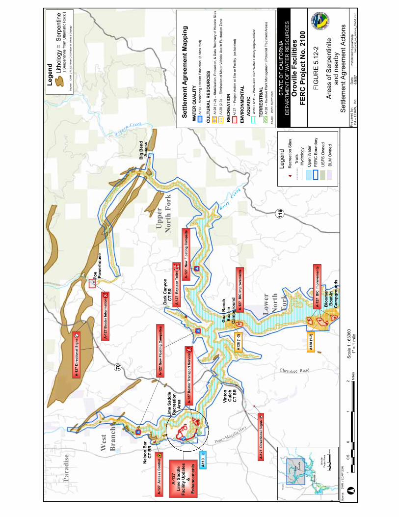
A-1
27B
oate
rInf
orm
atio
n
A-1
27N
ewFl
oatin
gC
amps
ites
A-1
27D
irect
iona
lSig
ns
A-1
27D
irect
iona
lSig
ns
A-1
27A
cces
sC
ontr
ol
A-1
27R
epla
ceTo
ilet
A-1
27Li
me
Sadd
leFa
cilit
yU
pdat
es&
Enha
ncem
ents
A-1
27N
ewFl
oatin
gC
amps
iteA
-127
Boa
terT
rans
port
Serv
ice
A-1
27B
ICIm
prov
emen
ts
A-1
27B
ICIm
prov
emen
ts
A12
8(1
-2)
A12
8(1
-2)
A11
3
Sour
ce:
DW
R/E
DAW
2006
Scal
e1
:633
601"
=1
mile
FrenchCree k
Big
Ben
dA
cces
s
Upper
NorthFork
Lower
North
Fork
119
Pentz-Ma
galia Hwy
Cherokee Road
Blo
omer
Boa
t-in
Cam
pgro
unds
Goa
tRan
chB
oat-i
nC
ampg
roun
d
Lim
eSa
ddle
Rec
reat
ion
Are
a
West
Branch
Berr
y
C ree
k
Vint
onG
ulch
CT
BR
Nel
son
Bar
CT
BR
Dar
kC
anyo
nC
TB
R
Poe
Pow
erho
use
70
Paradise
P:\2
000\
0s01
6.gi
s\ar
cmap
\ser
psoi
l_sa
_act
ions
_33x
51.m
xdPJ
--ED
AW
,In
c.D
ate
Prep
ared
by:
4/9/
07
STA
TEO
FC
ALI
FOR
NIA
DE
PA
RTM
EN
TO
FW
ATE
RR
ES
OU
RC
ES
Oro
ville
Faci
litie
sFE
RC
Proj
ectN
o.21
00
Area
sof
Serp
entin
itean
dne
arby
Settl
emen
tAgr
eem
entA
ctio
ns
FIG
UR
E5.
12-2
10
12
0.5
Mile
s
Para
dise
Oro
ville
Lake
Oroville Oro
ville
Proj
ectA
rea
Mile
s4
04
2
Lege
nd Lith
olog
y=
Serp
entin
e
Sour
ce:
DW
RG
IS20
03fro
mC
AD
ivis
ion
ofM
ines
&G
eolo
gy
[Ser
pent
inite
from
Ulta
maf
icR
ock
]
WAT
ERQ
UA
LITY
CU
LTU
RA
LR
ESO
UR
CES
A11
3--
Mon
itorin
g/H
ealth
Edu
catio
n(8
site
sto
tal)
A12
8(1
-2)-
-Sta
biliz
atio
n,P
rote
ctio
n,&
Dat
aR
ecov
ery
ofH
isto
ricS
ites
A12
8(2
-3)
--E
limin
atio
nof
Mot
orVe
hicl
eU
sein
Fluc
tuat
ion
Zone
REC
REA
TIO
NA
127
--P
roje
ctA
ctio
nat
Site
orFa
cilit
y(a
sla
bele
d)
Settl
emen
tAgr
eem
entM
appi
ng
AQ
UAT
ICA
110
/A11
1--
War
man
dC
old
Wat
erFi
sher
yIm
prov
emen
t
ENVI
RO
NM
ENTA
L
TER
RES
TRIA
L
Sour
ce:
DW
R/
ED
AW
2006
A12
6--
Inva
sive
Pla
ntM
anag
emen
t(P
oten
tialT
reat
men
tAre
as)
Trai
ls
Lege
nd
FER
CBo
unda
ry
Rec
reat
ion
Site
s
Hyd
rolo
gy
Ope
nW
ater
US
FSO
wne
d
BLM
Ow
ned

Draft Environmental Impact Report Oroville Facilities Relicensing—FERC Project No. 2100
May 2007 Page 5.12-26
This page intentionally left blank.

Chapter 5.0 Environmental Impacts
Page 5.12-27 May 2007
Impact 5.12-e: Result in a cumulatively considerable net increase of any criteria pollutant for which the Project region of influence is nonattainment under an applicable federal or State ambient air quality standard.
NO Under the No-Project Alternative, routine operations, maintenance, and recreational activities would continue. Emissions of gaseous and particulate pollutants would not be anticipated to change noticeably from the existing conditions. There would be noimpact from these activities.
PRO The region is nonattainment relative to a federal or State standard for ozone and PM10. NOX and ROG are the precursor pollutants for ozone. As described for Impact 5.12-f, NOX emissions for a “sample” project would be less than 5 tons per year; ROG emissions would be less than 1 ton per year; PM10 emissions would be less than 2 tons per year. Increasing visits to the area could add 5 tons per year of NOX and PM10 and 3 tons per year of ROG. With a number of projects occurring concurrently, the total emissions would remain less than the 100-tons-per-year levels where emissions are considered de minimis. Therefore, thecumulative emissions of the projects would not be considerable and the impact would be less-than-significant and no mitigation would be required.
FERC Impacts on air resources under the FERC Staff Alternative would be similar to those under the Proposed Project. The FERC Staff Alternative includes more robust monitoring of the Gravel Supplementation and Improvement Program (SA Article A102) and earlier implementation of the Riparian and Floodplain Improvement Program (SA Article A106). These impacts would be considered less-than-significant and no mitigation would be required.
Mitigation measure 5.12-e: No mitigation is required.

Draft Environmental Impact Report Oroville Facilities Relicensing—FERC Project No. 2100
May 2007 Page 5.12-28
This page intentionally left blank.

Chapter 5.0 Environmental Impacts
Page 5.13-1 May 2007
5.13 AGRICULTURAL RESOURCES
5.13.1 Regulatory Setting
Land management agencies, the location of lands within the study area managed by various local, State, and federal entities, and the management direction of these entities are discussed below. The description of land ownership, management, and use patterns within the study area applicable to agricultural resources is presented in Section 5.6.1, Land Use Regulatory Setting.
5.13.1.1 Williamson Act
The California Land Conservation Act of 1965, also known as the Williamson Act, is designed to preserve agriculture and open space lands by discouraging their premature and unnecessary conversion to urban uses. The act enables local governments to enter into contracts with private landowners for the purpose of restricting specific parcels of land to agricultural or related open space use. In return, landowners receive favorable tax assessments, with assumed property values much lower than full market value because they are based on farming and open space uses.
5.13.1.2 California Department of Conservation Farmland Mapping and Monitoring Program
The goal of the Farmland Mapping and Monitoring Program (FMMP) is to provide consistent, timely, and accurate data to decision makers for use in planning for the present and future of California's agricultural land resources. To meet this goal, the FMMP's objective is to provide maps and statistical data to the public, academia, and local, State, and federal governments to assist them in making informed decisions for the best utilization of California's farmland.
The FMMP was established in 1982 in response to what was by then a critical need for data on the nature, location, and extent of farmland, grazing land, and urban built-up areas in the State. Government Code Section 65570 mandates the FMMP to biennially report to the Legislature on the conversion of farmland and grazing land, and to provide maps and data to local government and the public. The FMMP was also directed to prepare and maintain an automated map and database system to record and report changes in the use of agricultural lands.
It was the intent of the Legislature and a broad coalition of building, business, government, and conservation interests that FMMP be non-regulatory, and provide a consistent and impartial analysis of agricultural land use and change in California. With this in mind, FMMP provides basic data from which observations and analyses can be made in the land use planning process.

Draft Environmental Impact Report Oroville Facilities Relicensing—FERC Project No. 2100
May 2007 Page 5.13-2
5.13.1.3 Prime Farmland and Farmland of Statewide Importance
In order to be shown on the Farmland Mapping and Monitoring Program’s Important Farmland Maps as Prime Farmland and Farmland of Statewide Importance, land must meet both the following land use and soil criteria:
Land Use—Has been used for irrigated agricultural production at some time during the 4 years prior to the Important Farmland Map date. Irrigated land use is determined by FMMP staff during examination of current aerial photos, local comment letters, and field verification.
Soil—The soil must meet the physical and chemical criteria for Prime Farmland or Farmland of Statewide Importance as determined by the U.S. Department of Agriculture (USDA) Natural Resources Conservation Service (NRCS). NRCS compiles lists of which soils in each survey area meet the quality criteria. Factors considered in qualification of a soil by NRCS include:
Water moisture regimes, available water capacity, and developed irrigation water supply;
Soil temperature range;
Acid-alkali balance;
Water table;
Soil sodium content;
Flooding (uncontrolled runoff from natural precipitation);
Erodability;
Permeability rate;
Rock fragment content; and
Soil rooting depth.
The term “Prime” as it refers to rating for agricultural uses has two meanings in California. The FMMP determines the location and extent of “Prime Farmland” as described above, while under the State's Williamson Act, land may be enrolled under the “Prime Land” designation if it meets certain economic or production criteria.
5.13.2 Impact Thresholds
The following thresholds are used to determine whether the alternatives would have a significant effect on agricultural resources. There would be a significant impact on agricultural resources if the alternatives would:
Chapter 5.0 Environmental Impacts
Page 5.13-3 May 2007
5.13-a: Convert Prime Farmland, Unique Farmland, or Farmland of Statewide Importance (Farmland), as shown on the maps prepared pursuant to the Farmland Mapping and Monitoring Program of the California Resources Agency, to non-agricultural use;
5.13-b: Conflict with existing zoning for agricultural use, or a Williamson Act contract; or
5.13-c: Involve other changes in the existing environment which, due to their location or nature, could result in conversion of Farmland to non-agricultural use.
5.13.3 Method of Analysis
Qualitative effects assessments were completed to evaluate the potential impacts of the No-Project Alternative, the Proposed Project, and the FERC Staff Alternative on agricultural production in the vicinity of the Oroville Facilities. These qualitative effects evaluations included the potential for the No-Project, Proposed Project, or FERC Staff Alternative to convert Prime Farmland, Unique Farmland or Farmland of Statewide importance to non-agricultural use; change agricultural zoning or conflict with Williamson Act contracts; or alter existing environmental conditions such that it could result in conversion of Farmland to non-agricultural use. Consideration of potential project affects on existing conditions, which could result in conversion of Farmland to non-agricultural uses included Feather River Service Area (FRSA) changes in irrigation water temperature as well as ongoing effects of increased reliability of irrigation water supply under each of the alternatives.
Local FRSA water and irrigation districts have expressed concerns regarding the suitability of irrigation water temperatures at the Thermalito Afterbay agricultural diversions and the potential for exposure to cold water during critical periods to reduce rice yields in some portions of the FRSA. Although a variety of crops are grown in the FRSA, rice is the only crop with a concern regarding irrigation water temperatures that have been identified or expressed by the FRSA water and irrigation districts or growers.Therefore, the evaluation of potential changes in irrigation water temperature from the implementation of the project alternatives and the potential for those changes to result in conversion of Farmland to non-agricultural uses was the focus of this component of the effects analysis.
The evaluation period chosen for the analyses of potential effects of irrigation water temperature changes on rice was May 1 through July 31. Because water temperature–related effects on rice yield reportedly occur between planting and the onset of the reproductive phase of rice growth (see Section 4.13 for discussion) and because the majority of planting in the FRSA occurs during May, the period between May 1 and July 31 encompasses the period during which the majority of rice in the FRSA is potentially vulnerable to cold water–related effects. Water quality modeling for Thermalito Afterbay does not support absolute water temperature value prediction or provide values suitable for alternatives comparison. This is due to the dynamic nature of the flow and water temperature regime as well as the short period of available record

Draft Environmental Impact Report Oroville Facilities Relicensing—FERC Project No. 2100
May 2007 Page 5.13-4
of agricultural diversion water temperatures in Thermalito Afterbay (see discussion in Section 5.2.2.3, Surface Water Quality Method of Analysis). The evaluation of potential changes in irrigation water temperature was conducted qualitatively for the implementation of the initial new license period of the Proposed Project. Similarly, the potential future facilities modification(s) of the Proposed Project were qualitatively analyzed due to the constraints of the Thermalito Afterbay modeling and due to the uncertainty of the detailed design and operational characteristics of the potential future facilities modifications at this time. Analysis of potential water temperature changes resulting from the potential implementation of the future facilities modifications is presented in Section 5.2.2, Surface Water Quality. For the purposes of the analysis of potential effects on irrigation water temperatures, there are no differences between the Proposed Project and the FERC Staff Alternative; therefore, the analysis was focused on the Proposed Project.
5.13.4 Impacts and Mitigation Measures
The following section describes the beneficial effects and potentially adverse impacts of the Proposed Project, including both programmatic and project-level analyses. Table 5.13-1 indicates the SA articles or actions that could have an effect on agriculturalresources, and whether these effects are expected to be beneficial, less-than-significant, or would be less-than-significant following implementation of recommended mitigation measures.
Table 5.13-1. Environmental effects on agricultural resources.
Alternative(s) Article # and Title Level of CEQA Analysis
Nature of Potential Impact(s) Effect
PRO, FERC A107—Feather River Fish Hatchery water temperature
Project (107.2) No change in water temperatures at agricultural diversions
NI
PRO, FERC A108—Minimum Flow and Other Measures
Project (A108.1 only); Programmatic (A108.2 and A108.3 only)
Slightly reduced water temperatures at agricultural diversions in the Thermalito Afterbay
B/LTS
Coding:
B = Action with potential to result in a beneficial effect; could involve short-term, less-than-significant, construction-related impacts that would be avoided or reduced through the use of Best Management Practices (BMPs). See Appendix D.
LTS = Action that would result in less-than-significant impact on resource.
NI = Action that would result in no impact.
In addition to the Proposed Project, this DEIR analyzes the No-Project Alternative and the FERC Staff Alternative. Impacts on agricultural resources from implementing the FERC Staff Alternative are the same as those anticipated from implementation of the Proposed Project unless noted. Potential impacts are identified as follows:NO (No-Project), PRO (Proposed Project), and FERC (FERC Staff Alternative). All alternatives analyzed result in less-than-significant impacts on agricultural resources.

Chapter 5.0 Environmental Impacts
Page 5.13-5 May 2007
5.13.4.1 Program and Project-Level Impacts and Mitigation Measures
Continuation of Oroville Facilities operations, construction of new or improved facilities, and implementation of new programs could result in impacts on agricultural resources.Project-level impact evaluations include initial new license period, water temperature management actions (under SA Article 107.2 and A108.1). Program-level impact evaluations include potential future facility modifications (SA Articles A108.2 and A108.3), which currently include, but are not necessarily limited to, Palermo Canal improvements, a Hyatt intake extension, river valves improvements, a canal around Thermalito Afterbay, a canal through Thermalito Afterbay, an alternate Thermalito Afterbay Outlet and channel, and a water temperature curtain within Thermalito Afterbay. Preliminary analysis of potential water temperature changes resulting from implementation of the future facilities modifications is presented in Section 5.2.2, Surface Water Quality.
Impacts of the No-Project Alternative Relative to Existing Conditions
Under the No-Project Alternative, operations affecting Thermalito Afterbay would not differ appreciably from operations under Existing Conditions during the period of rice yield sensitivity to irrigation water temperatures (May through July). Therefore, the Thermalito Afterbay water temperature regime is not expected to significantly change under the No-Project Alternative compared to the water temperature regime observed under Existing Conditions. Project benefits that occur under Existing Conditions and that would continue to occur and accrue under the implementation of the No-Project Alternative include water supply reliability, flood control, foregone canal conveyance system maintenance, and foregone diversion fish screen amortized capital costs and maintenance. Some changes in future water allocation and delivery timing patterns would occur under the No-Project Alternative compared to Existing Conditions, which would slightly alter the seasonal pattern of flow releases from the project. However, these changes likely would not substantively affect water residence times in Thermalito Afterbay during the May-through-July analytical period. (See Section 5.2.1, Surface Water Quantity, for additional information on flow changes associated with any of the project alternatives.) Because changes to the effective residence time of water in Thermalito Afterbay under the No-Project Alternative would be minor, it is likely that irrigation water temperatures at the agricultural diversions also would not be substantively altered under the No-Project Alternative compared to Existing Conditions.
In addition, no conversion of Prime Farmland, Unique Farmland, or Farmland of Statewide Importance to a non-agricultural use is anticipated. No conflict with existing zoning for agricultural use, a Williamson Act contract, or other changes in the existing environment which, due to their location or nature, could result in conversion of Farmland to non-agricultural use would occur under the No-Project Alternative, relative to Existing Conditions.

Draft Environmental Impact Report Oroville Facilities Relicensing—FERC Project No. 2100
May 2007 Page 5.13-6
Impacts of the Proposed Project Relative to Existing Conditions
Oroville Facilities operations provide substantial benefits to agricultural production in the FRSA, but also affect water temperatures and their distribution in Thermalito Afterbay, which affect water temperatures at the agricultural diversions (see Section 5.2.2, Surface Water Quality, for additional information on water temperatures in Thermalito Afterbay). Project benefits that occur under Existing Conditions as well as the No-Project Alternative and that would continue to occur and accrue under implementation of the Proposed Project include water supply reliability, flood control, foregone canal conveyance system maintenance, and foregone diversion fish screen amortized capital costs and maintenance. Oroville Facilities operations that affect Thermalito Afterbay water temperatures include Oroville Dam release water temperatures, and those operational variables that determine the effective residence time of water in Thermalito Afterbay (see Section 5.2.2, Surface Water Quality, for additional information on water temperatures in Thermalito Afterbay). Implementation of the Proposed Project would occur in two stages as described in Chapter 3.
Description of the second stage, which includes study of potential future facilities modifications for the Proposed Project, is contained in Section 3.3.2. The potential future facilities modifications, as they are presently defined in the SA, are preliminarily evaluated for water temperature changes at the Thermalito Afterbay agricultural diversions for potential effects on Basin Plan agricultural beneficial uses in Section 5.2.2, Surface Water Quality.
As discussed in Section 5.2.2, Surface Water Quality, new minimum Low Flow Channel (LFC) flows and water temperature targets under the Proposed Project to benefit anadromous fish would result in reductions in water temperature, consistent with SA targets, of up to 2 degrees Fahrenheit (°F) at Robinson Riffle. Depending on the time of year, and hydrologic and ambient conditions, this benefit would likely result in either no water temperature change, or under conditions that are expected to occur only infrequently, a less than 2°F reduction in water temperature at the Thermalito Afterbay agricultural diversions. This discussion pertains to the evaluation of water temperature effects on rice under the Proposed Project initial new license period as compared to Existing Conditions.
Water temperature targets could differ between the initial new license period (operational changes only) and the period after completion of potential future facilities modifications (see Section 3.3.2, Proposed Project). Any future facilities modifications would be subject to subsequent environmental documentation prior to construction.
During the Proposed Project initial new license period, either no water temperature changes would occur or infrequent changes of less than 2°F at the Thermalito Afterbay agricultural diversions would occur. Since these changes would be infrequent and of relatively small magnitude, water temperature changes would not be expected to substantially increase rice yield loss attributable to cold water exposure, relative to Existing Conditions. Potential rice yield loss with the implementation of the Proposed Project would not be expected to result in any conversion of farmland to non-agricultural

Chapter 5.0 Environmental Impacts
Page 5.13-7 May 2007
use. Additionally, with the continued benefit of reliable water supply to the FRSA, the net result of the implementation of the Proposed Project initial new license period would have no impact on conversion of farmland to nonagricultural use.
Implementation of the potential future facilities modifications (as they are currently defined in the SA) under the Proposed Project may likely result in either beneficialeffects or less-than-significant impacts of conversion of farmland to non-agricultural uses. Prior to construction, these potential future facilities modifications would be subject to a subsequent environmental analysis and documentation that would include a detailed analysis of potential effects on agricultural beneficial uses or potential conversion of farmland to other uses.
No conversion of Prime Farmland, Unique Farmland, or Farmland of Statewide Importance to a non-agricultural use is anticipated with implementation of the Proposed Project. No conflict with existing zoning for agricultural use, a Williamson Act contract, or other changes in the existing environment that, due to their location or nature, could result in conversion of Farmland to non-agricultural use would occur under the Proposed Project, relative to Existing Conditions.
Impacts of the Proposed Project Relative to the No-Project Alternative
Impacts associated with implementation of the Proposed Project relative to the No-Project Alternative are expected to be similar to those associated with implementation of the Proposed Project relative to Existing Conditions. Therefore, implementation of the Proposed Project would likely reduce water temperatures slightly at the agricultural diversions during the agricultural analytical period (May through July) over the entire period of the new FERC license. Potential rice yield loss with the implementation of the Proposed Project would not be expected to result in any conversion of farmland to nonagricultural use. Additionally, with the continued benefit of reliable water supply to the FRSA, the net result of the implementation of the Proposed Project initial new license period would have no impact on conversion of farmland to nonagricultural use.
Implementation of the potential future facilities modifications (as they are currently defined in the SA) under the Proposed Project as compared to the No-Project Alternative may likely result in either beneficial effects or less-than-significant impacts of conversion of farmland to non-agricultural uses. These potential future facilities modifications would be subject to subsequent environmental analysis and documentation that would include a detailed analysis of potential effects on agricultural beneficial uses or potential conversion of farmland to other uses, prior to construction.
No conversion of Prime Farmland, Unique Farmland, or Farmland of Statewide Importance to a non-agricultural use is anticipated with implementation of the Proposed Project. No conflict with existing zoning for agricultural use, a Williamson Act contract, or other changes in the existing environment that, due to their location or nature, could result in conversion of Farmland to nonagricultural use would occur under the Proposed Project relative to the No-Project Alternative.

Draft Environmental Impact Report Oroville Facilities Relicensing—FERC Project No. 2100
May 2007 Page 5.13-8
Impacts of the FERC Staff Alternative Relative to Existing Conditions and No-Project AlternativeThe FERC Staff Alternative does not differ substantively from the Proposed Project in regard to potential effects on agricultural diversion water temperatures or agricultural land use. Therefore, the effects on agricultural water temperatures and on land use are the same for the FERC Staff Alternative as described above for the Proposed Project for both comparisons with Existing Conditions as well as the No-Project Alternative.Implementation of the FERC Staff Alternative, both for the initial new license period and after the potential future facilities modifications, would result in no impact on conversion of farmland to non-agricultural use.Impact 5.13-a: Convert Prime Farmland, Unique Farmland, or Farmland of Statewide Importance (Farmland), as shown on the maps prepared pursuant to the Farmland Mapping and Monitoring Program of the California Resources Agency, to non-agricultural use.
Impact 5.13-b: Conflict with existing zoning for agricultural use, or a Williamson Act contract.
Continuation of Oroville Facilities operations, construction of new or improved facilities, and implementation of new programs could result in impacts on agricultural resources.
NO, PRO, FERC No conversion of Farmland to a nonagricultural use, or conflicts with existing agricultural zoning or Williamson Act contracts; therefore, no impact would occur and therefore no mitigation would be required.
Impact 5.13-c: Involve other changes in the existing environment which, due to their location or nature, could result in conversion of Farmland to non-agricultural use.
Continuation of Oroville Facilities operations, construction of new or improved facilities, and implementation of new programs could result in impacts on agricultural resources.
NO Changes to the effective residence time of water in Thermalito Afterbay would be small relative to Existing Conditions. Therefore, irrigation water temperatures either would not change or would slightly decrease resulting in little or no change in rice yields. Therefore, rice yield changes would not be substantial enough to result in conversion of farmland to nonagricultural use. Therefore, no impact would occur.
PRO, FERC The Proposed Project and FERC Staff Alternative irrigation water temperatures during the initial new license period either would not change or would slightly decrease, resulting in little or no change in rice yields. Therefore, rice yield changes would not be substantial enough to result in conversion of farmland to nonagricultural use. Therefore, no impact would occur.
Chapter 5.0 Environmental Impacts
Page 5.13-9 May 2007
Proposed Project and FERC Staff Alternative potential future facilities modifications could result in either beneficial effects or less-than-significant impacts of conversion of farmland to non-agricultural uses and therefore no mitigation would be required.

Draft Environmental Impact Report Oroville Facilities Relicensing—FERC Project No. 2100
May 2007 Page 5.13-10
This page intentionally left blank.

Chapter 5.0 Environmental Impacts
Page 5.14-1 May 2007
5.14 TRANSPORTATION AND TRAFFIC
5.14.1 Regulatory Setting
5.14.1.1 State and Regional Transportation Plans
Transportation planning agencies involved in developing and maintaining Butte County's regional and countywide circulation system include the California Transportation Commission (CTC) and the Butte County Association of Governments (BCAG). The California Department of Transportation (Caltrans) is responsible for implementing statewide policy of the CTC. Both the CTC and BCAG are required to develop and maintain respective state and regional transportation plans that rely on input from local city and county government general plans, including their respective circulation elements.
The major emphasis of the Butte County Regional Transportation Plan (RTP) is on transportation improvements that are needed during the next 5 years. New transportation projects that plan to utilize State or federal monies must be included in the RTP. Projects for maintenance, rehabilitation, and reconstruction are not included in the RTP (Government Code Section 65082). The Butte County RTP is prepared and updated by BCAG and used as a guide for preparing BCAG's annual Regional Transportation Improvement Program (RTIP) and Federal Transportation Improvement Program (FTIP). The Butte County RTIP annually identifies and sets priority for new transportation projects proposed and needed in Butte County during the next 5-year period, and the FTIP sets priorities for federally funded transportation projects in the Chico urban area.
The planning relationship between the RTP and the County's Circulation Element is parallel. The Circulation Element's countywide guidance and programs, however, should precede and influence those programs stated in the RTP. The principal difference between the Circulation Element and the RTP is that the former is intended to provide more long-term transportation planning guidance as part of Butte County's General Plan whereas the latter focuses on shorter term transportation development programs that include both city and County plans.
5.14.1.2 Butte County General Plan Circulation Element
The Circulation Element of the Butte County General Plan is a guide to managing and developing Butte County’s future transportation and circulation system. The Circulation Element provides guidance regarding continued maintenance of Butte County’s transportation system, which is vital for ensuring a continued present level of mobility, as well as facilitating improved development and mobility in the future. The Circulation Element also identifies minimum Level of Service standards for urban streets and rural roads.

Draft Environmental Impact Report Oroville Facilities Relicensing—FERC Project No. 2100
May 2007 Page 5.14-2
5.14.2 Impact Thresholds
The following thresholds are used to determine whether the alternatives would have a significant effect related to transportation and traffic. There would be a significant impact if the alternatives would:
5.14-a: Cause an increase in traffic, which is substantial in relation to the existing traffic load and capacity of the street system (i.e., result in a substantial increase in either the number of vehicle trips, the volume-to-capacity ratio on roads, or congestion at intersections);
5.14-b: Exceed, either individually or cumulatively, an LOS standard established by the county congestion management agency for designated roads or highways;
5.14-c: Result in a change in air traffic patterns, including either an increase in traffic levels or a change in location that results in substantial safety risks;
5.14-d: Substantially increase hazards due to a design feature (e.g., sharp curves or dangerous intersections) or incompatible uses;
5.14-e: Result in inadequate emergency access;
5.14-f: Result in inadequate parking capacity; or
5.14-g: Conflict with adopted policies, plans, or programs supporting alternative transportation (e.g. bus turnouts, bicycle racks).
5.14.3 Method of Analysis
The analysis of traffic effects was conducted by characterizing potential changes in traffic volumes resulting from additional recreation visitors, construction and operations and maintenance (O&M) activities, and local population supported by recreation visitor and O&M spending. Specific programs and projects that can be expected to affect recreation, construction, and O&M activity are described in Table 5.7-1 in Section 5.7, Recreational Resources. The potential effect of these programs and projects on recreation use, commuting workers, and the local population provides the basis for assessing the potential impact on traffic-related issues under each alternative.
The sources and methods used to develop the visitation, employment, and populationprojections used to estimate traffic volumes are discussed in Section 5.9.1, Population and Housing, and Section 5.9.2, Public Services. Although visitation, employment, and population projections were not developed specifically for the FERC Staff Alternative, effects on traffic volumes under this alternative are anticipated to be similar to those of the Proposed Project.
For assessing whether the projected increases in traffic are substantial in relation to the existing traffic load and capacity of the street system, Level of Service (LOS) is the measure employed. The Butte County General Plan Circulation Element identifies LOS

Chapter 5.0 Environmental Impacts
Page 5.14-3 May 2007
B as the goal for rural roads but indicates that service should be considered to be acceptable at level of Service C, particularly when fiscal, environmental or site constraints are prohibitive. For the purpose of assessing county roads, LOS C is considered the minimum acceptable LOS on weekdays.
The Caltrans Transportation Concept Reports for SR 70, SR 99 and SR 162 indicate the Concept LOS for segments of each road. The Concept LOS is the long term goal for each facility. In this case, the concept LOS for SR 70 in Butte County ranges from LOS D south of Oroville, to LOS B on the freeway through Oroville, to LOS C north of Oroville. The concept LOS for SR 99 in Butte County is LOS D south of the Skyway in Chico, LOS C through Chico, and LOS D north of Chico to the Tehama County line.The concept LOS on SR 162 is LOS E west of SR 70 and LOS B east of SR 70.
Caltrans District 3 has recently established a basis for identifying incrementally significant impacts to mainline highways. Traffic impacts on roadway segments are significant if they cause currently acceptable conditions to deteriorate to an unacceptable Level of Service, or if a project results in a 1% increase in volume on a freeway that will operate at an unacceptable LOS without the project.
Areawide Travel Effects
Implementation of the project alternatives may increase the volume of traffic to and from the project area. This increased travel will affect roadways in three ways. First, the regional roadway system providing access to the project may see additional traffic as motorists drive to and from the facilities. Second, the roads in the immediate area of the facilities may be used to reach individual features. Thirdly, the entire Butte County road system would theoretically see an incremental traffic increase as a result of the growth sustained by the operation of Oroville Facilities.
To estimate recreation visitor-related traffic volumes for evaluating area wide travel effects, information from Study Plan R-9 (SP-R9), Existing Recreation Use (DWR 2004), regarding visitation at various locations in the Oroville Facilities area was used. Visitation estimates were derived from traffic counts conducted at permanent count stations on access routes. Average daily visitation during the 2002-03 recreation seasons (May 15 through September 15) is estimated to be 6,724 recreation days on a weekday basis. (Weekdays are used to characterize visitation here because baseline traffic volumes and LOS established by most regional transportation planning agency, including BCAG, reflect weekday data.) This estimate reflects the average number of recreation days by all visitors (i.e., visitors from all locations, both within and outside of Butte County). To account for use of multiple facilities within the recreation area on one day by the same visitor, “recreation days” were converted to “visitor days.” An equivalency factor of 0.627, which was derived by TCW Economics using data compiled from responses to the Onsite Visitor Survey conducted for the Oroville Facilities Relicensing, was used for this conversion. Applying the overall automobile occupancy rate developed for SP-R9 (i.e., 2.5 persons per vehicle) suggests that the existing automobile traffic flow associated with use of recreation areas would be in the range of 1,690 inbound and 1,690 outbound vehicles on a summer weekday.

Draft Environmental Impact Report Oroville Facilities Relicensing—FERC Project No. 2100
May 2007 Page 5.14-4
Under all of the alternatives, including the No-Project Alternative, use of recreation facilities and travel on roadways in the project area would increase in the future due to recreation demand generated by regional and statewide population growth. Regionally, the population in Butte County supported by jobs directly and indirectly generated by visitor and O&M spending also is expected to increase. Under the Proposed Project and FERC Staff Alternative, implementation of the SA Articles also would result in an increase in visitors because of recreation improvements, construction activity, and O&M workers commuting from out of county. The change in the number of recreation visitors, the local population supported by the spending of recreation visitors, and commuting workers would contribute to increased use of local roads, potentially resulting in deterioration of levels of service and roadway conditions.
Under the No-Project Alternative, anticipated statewide population growth will increase the level of visitation to the Oroville Facilities over the next 20 years and increase the amount of traffic on roads that lead to the project area. Current peak weekday visitation is expected to increase from the current 6,724 recreation days to 9,032 recreation days under the No-Project Alternative and 9,779 recreation days under the Proposed Project. This increase of 2,308 recreation days under the No-Project Alternative is the equivalent of 1,450 visitor days, and using the assumed automobile occupancy rate, an additional 580 inbound and 580 outbound daily vehicle trips are projected. Under the Proposed Project, the increase of 3,055 recreation days is the equivalent of 1,920 visitor days, and an additional 780 inbound and 780 outbound daily trips.
Areawide traffic to and from the Oroville Facilities would also increase as a result of changes to O&M practices. Implementation of the Proposed Project would entail changes in O&M practices at the Oroville Facilities that would likely increase the number of O&M workers commuting to the project area, thereby contributing to the usage of local roadways. As discussed in Section 5.9.2, Public Services, the number of additional O&M workers needed to implement the Proposed Action in the PDEA was estimated at 65 positions. Assuming 1 inbound and 1 outbound daily trip per position, 65 additional inbound and 65 additional outbound daily trips could be expected. Of these additional jobs, only a small number (fewer than five, based on the existing commuting patterns of Oroville Facilities employees) would likely be filled by persons who would commute into Butte County.
Implementation of the Proposed Project could result in construction activity that would increase automobile and truck traffic to and from the Oroville Facilities. Construction projects are estimated to generate a total of about 1,800 jobs, or an average of 180 jobs per year if the projects were all constructed within a 10-year timeframe. Commuting by construction workers could add 180 inbound and 180 outbound trips to the roads serving the Oroville Facilities. Although the extent of truck traffic is uncertain because the projects involving construction have not been fully defined, construction activity is assumed for analysis purposes to generate up to several hundred truckloads annually.Depending on the distribution of truck activity across the construction season, this level of annual truck activity would generate about five truckloads (i.e, five inbound and five outbound trucks) on a daily basis.

Chapter 5.0 Environmental Impacts
Page 5.14-5 May 2007
All together, compared to current conditions, the No-Project Alternative could result in an additional 580 inbound and 580 outbound daily trips on the streets providing access to the project area, as measured at the end of the 20-year planning horizon. Combining increased visitation, O&M changes, and construction workers and trucks, the Proposed Project could result in an additional 1,030 inbound and 1,030 outbound trips, as compared to current conditions. Compared to the No-Project Alternative, the Proposed Project increase would be 450 inbound and 450 outbound daily trips spread across all of the roads providing access to the Oroville Facilities. The overall traffic increase described above would be distributed to streets near the site and to the regional circulation system. However, the incremental increase in traffic volumes under the Proposed Project would be about 0.8% in comparison to existing conditions based on the increase in average daily population. (Although visitation and project-related population projections beyond 2020 are not available for this analysis, growth in recreation use and population supported by visitor spending is presumed to increase at rates similar to the rate between 2002 and 2020 throughout the 50-year term of the anticipated license).
Under the project alternatives, the local population directly and indirectly supported by recreation visitor spending also would increase, thereby increasing the use of roadways throughout the county. Under the No-Project Alternative, this population is projected to increase from 2,360 persons in 2002-03 to 2,770 persons in 2020, representing a 410-person increase. Under the Proposed Project, this population, which also includes resident O&M workers, is projected to increase from 2,360 persons in 2002-03 to 3,160 persons in 2020, representing an 800-person increase. About half of this increase would be attributable to regional and statewide population growth unrelated to project improvements. Based on an average density per household of 2.4 persons per household (California Department of Finance 2007) and 9.6 trips per household (Institute of Transportation Engineers 2003), the increased population supported by visitor and O&M spending under the No-Project Alternative would generate about 1,640 additional vehicle trips daily and the Proposed Project would generate about 3,200 additional vehicle trips daily on highways and roads throughout the county.
Localized Impacts
Under the Proposed Project, the Recreation Management Plan (SA Article A127) identifies the need for recreation enhancements at several existing recreation sites that could have localized roadway impacts. Table 5.14-1 identifies the recreation enhancements, and presents traffic volume information for the road segments immediately adjoining these facilities that would most likely experience traffic volume increases. As shown in the table, proposed actions include establishing additional campsites and parking spaces at marinas, campgrounds, and day use areas at Lake Oroville and Thermalito Afterbay. Because of existing capacity and use conditions, the recreational enhancements would likely lead to some increase in recreational activity, and consequently an increase in traffic volumes on the road segments identified in Table 5.14-1.

Dra
ft E
nviro
nmen
tal I
mpa
ct R
epor
t O
rovi
lle F
acilit
ies
Rel
icen
sing
—FE
RC
Pro
ject
No.
210
0
May
200
7 P
age
5.14
-6
Tabl
e 5.
14-1
. Tr
affic
vol
ume
info
rmat
ion
for r
oadw
ays
pote
ntia
lly a
ffect
ed b
y pr
opos
ed
recr
eatio
n en
hanc
emen
t mea
sure
s.
R
ecre
atio
n Fa
cilit
y Tr
affic
Pr
imar
y R
oad
Affe
cted
Pr
ojec
ted
Peak
Sea
son
Dai
ly T
raffi
c In
crea
se
(% o
f exi
stin
g ba
ckgr
ound
) To
tal
Proj
ecte
d D
aily
Tra
ffic
Prop
osed
Pro
ject
Prop
osed
M
easu
re
(loca
tion
and
desc
riptio
n)
Low
est
Mon
thly
W
eekd
ay
Ave
rage
(2
002
coun
ts)1,
3
Peak
Sea
son
Wee
kday
A
vera
ge
(200
2 co
unts
)2,3
Roa
d N
ame
and
Use
s
Exis
ting
Traf
fic(2
4-H
our
Wee
kday
C
ount
s)4
Leve
l of
Serv
ice
(200
3 es
t.)5
No
Proj
ect6
Due
to
Incr
ease
d C
apac
ity
Due
to
Enha
nced
Q
ualit
y 7
Tota
l of N
o Pr
ojec
t and
Pr
opos
ed
Proj
ect8
Exis
ting,
N
o Pr
ojec
t, an
d Pr
opos
ed
Proj
ect9
Leve
l of
Serv
ice
Lim
e Sa
ddle
C
ampg
roun
d:
10 a
dditi
onal
R
V c
amp-
site
s,
1 si
x-un
it gr
oup
RV
cam
psite
50(N
ovem
ber/
Janu
ary)
150–
200
Lim
e Sa
ddle
R
oad
(But
te C
o.)
Not
e: ro
ad u
sed
only
for r
ecre
atio
n ac
cess
341
(Jun
e 20
01)
C
50 to
70
70
20 to
25
140
to 1
65
480
to 5
05
C
Lim
e Sa
ddle
B
oat R
amp
and
Mar
ina:
60
addi
tiona
l ve
hicl
e/tra
iler
park
ing
spac
es
180
(Oct
ober
)60
0–80
0 Pe
ntz
Roa
d (B
utte
Co.
) N
ote:
road
ser
ves
rura
l res
iden
tial
area
s an
d lin
ks
City
of P
arad
ise
and
SR
70
1,95
9(A
ug. 1
999)
2,
017
(Jul
y 20
03)
C
205
to 2
75
100
70 to
95
375
to 5
70
2,39
5 to
2,
590
C
Bid
wel
l Can
yon
Mar
ina:
90
addi
tiona
l ve
hicl
e pa
rkin
g sp
aces
340
(Oct
ober
)80
0–1,
200
Kelly
Rid
ge R
oad
(But
te C
o.)
Not
e: ro
ad s
erve
s re
side
ntia
l are
a
2,18
7(J
uly
2001
) C
27
5 to
415
80
95
to 1
40
450
to 6
35
2.64
0 to
2,
825
C
Oro
ville
Dam
D
ay U
se A
rea:
10
0 ad
ditio
nal
park
ing
spac
es
460
(Dec
embe
r)80
0–92
0 C
anyo
n D
rive
(B
utte
Co.
— O
live
Hw
y. to
Oro
Dam
B
lvd.
) Not
e: R
oad
serv
es re
side
ntia
l ar
ea
1,87
3(J
uly
2001
) 3,
199
(Jul
y 20
01)
C
275
to 3
15
200
95 to
110
57
0 to
625
3,
770
to
3,82
5C

Cha
pter
5.0
E
nviro
nmen
tal I
mpa
cts
P
age
5.14
-7
May
200
7
Tabl
e 5.
14-1
. Tr
affic
vol
ume
info
rmat
ion
for r
oadw
ays
pote
ntia
lly a
ffect
ed b
y pr
opos
ed
recr
eatio
n en
hanc
emen
t mea
sure
s.
R
ecre
atio
n Fa
cilit
y Tr
affic
Pr
imar
y R
oad
Affe
cted
Pr
ojec
ted
Peak
Sea
son
Dai
ly T
raffi
c In
crea
se
(% o
f exi
stin
g ba
ckgr
ound
) To
tal
Proj
ecte
d D
aily
Tra
ffic
Prop
osed
Pro
ject
Prop
osed
M
easu
re
(loca
tion
and
desc
riptio
n)
Low
est
Mon
thly
W
eekd
ay
Ave
rage
(2
002
coun
ts)1,
3
Peak
Sea
son
Wee
kday
A
vera
ge
(200
2 co
unts
)2,3
Roa
d N
ame
and
Use
s
Exis
ting
Traf
fic(2
4-H
our
Wee
kday
C
ount
s)4
Leve
l of
Serv
ice
(200
3 es
t.)5
No
Proj
ect6
Due
to
Incr
ease
d C
apac
ity
Due
to
Enha
nced
Q
ualit
y 7
Tota
l of N
o Pr
ojec
t and
Pr
opos
ed
Proj
ect8
Exis
ting,
N
o Pr
ojec
t, an
d Pr
opos
ed
Proj
ect9
Leve
l of
Serv
ice
Afte
rbay
O
utle
t:20
-site
prim
itive
cam
pgro
und,
fiv
e to
ten
day-
use
site
s
60(F
ebru
ary)
18
0–43
0 La
rkin
Roa
d (B
utte
Co.
) N
ote:
road
ser
ves
rura
l agr
icul
tura
l an
d re
side
ntia
l ar
ea
2,58
9(J
uly
1998
) C
60
to 2
75
100
20 to
50
180
to 4
25
2,77
0 to
3,
015
C
Not
es:
1 Dat
a pr
esen
ted
refle
ct a
vera
ge d
aily
traf
fic v
olum
es (i
nbou
nd a
nd o
utbo
und)
dur
ing
the
low
est m
onth
of t
he 2
002-
03 s
tudy
per
iod,
whi
ch is
iden
tifie
d in
par
enth
eses
for e
ach
recr
eatio
n si
te.
Dat
a ar
e dr
awn
from
DW
R tr
affic
cou
nter
dat
a.
2 Dat
a pr
esen
ted
refle
ct a
vera
ge d
aily
traf
fic v
olum
es (i
nbou
nd a
nd o
utbo
und)
dur
ing
the
May
thro
ugh
Sep
tem
ber (
peak
sea
son)
of 2
002.
Dat
a ar
e dr
awn
from
DW
R tr
affic
co
unte
r dat
a.
3 Dat
a fo
r Lim
e S
addl
e C
ampg
roun
d re
flect
s w
eeke
nd d
aily
ave
rage
use
of f
acili
ty b
y re
crea
tion
visi
tors
at t
hat s
ite a
nd a
t Nel
son
Bar
car
-top
boat
ram
p (s
erve
d by
the
sam
e ro
ad) a
s re
porte
d in
SP
-R9
repo
rt. B
ecau
se s
ite o
bser
vatio
ns in
dica
ted
appr
oxim
atel
y 2
peop
le p
er v
ehic
le, a
vera
ge u
se w
as d
ivid
ed b
y 2
to a
rriv
e at
an
appr
oxim
atio
n of
da
ily v
ehic
le tr
affic
. Tr
affic
cou
nts
for O
rovi
lle D
am D
UA
incl
ude
traffi
c ac
cess
ing
the
Spi
llway
DU
A v
ia th
e O
rovi
lle D
am c
rest
road
. 4 D
ata
from
But
te C
ount
y P
ublic
Wor
ks, T
raffi
c C
ount
s ta
ble,
Aug
ust 2
2, 2
006.
Dat
a se
lect
ed a
re fr
om tr
affic
cou
nter
sta
tions
in c
lose
st p
roxi
mity
to th
e re
crea
tion
faci
lity
of
inte
rest
. W
eeke
nd c
ount
s w
ere
not a
vaila
ble.
5 D
ata
from
But
te C
ount
y A
ssoc
iatio
n of
Gov
ernm
ents
, 200
4 R
egio
nal T
rans
porta
tion
Pla
n. L
evel
“C” i
s de
fines
as
“sta
ble
flow
” but
with
“occ
asio
nal b
acku
ps b
ehin
d le
ft-tu
rnin
g ve
hicl
es a
t int
erse
ctio
ns.”
How
ever
, the
Reg
iona
l Tra
nspo
rtatio
n P
lan
does
not
spe
cify
Lev
el o
f Ser
vice
abo
ve “C
.” R
oads
with
Lev
els
of S
ervi
ce o
f A o
r B (l
ess
traffi
c co
nges
tion)
are
cat
egor
ized
in th
e P
lan
as le
vel “
C.”
6 Inc
reas
e ba
sed
on in
crea
se in
vis
itor d
ays
due
to s
tate
wid
e po
pula
tion
incr
ease
ove
r 20
year
s. T
his
is e
qual
to 3
4.3%
of e
xist
ing
trave
l, an
d w
ould
als
o re
pres
ent t
he “n
o pr
ojec
t” in
crea
se.
7 Inc
reas
e ba
sed
on in
crea
se in
vis
itor d
ays
due
to th
e en
hanc
emen
t inc
lude
d in
ove
rall
proj
ect.
Thi
s is
equ
al to
11.
8% o
f exi
stin
g tra
vel.
8 Sum
of s
peci
fic p
roje
ct tr
affic
, tra
ffic
incr
ease
due
to s
tate
wid
e gr
owth
and
incr
ease
due
to o
vera
ll ar
ea e
nhan
cem
ents
. 9 S
um o
f 8 p
lus
exis
ting
traffi
c vo
lum
es.

Draft Environmental Impact Report Oroville Facilities Relicensing—FERC Project No. 2100
May 2007 Page 5.14-8
Locally, the amount of additional traffic associated with increased visitation due tostatewide population growth and the additional traffic resulting from increased visitation due to the overall effect of project enhancements also is noted in Table 5.14-1. Measured as a percentage of total existing traffic to and from the facilities, the increase due to statewide growth is equal 34.5% of existing travel. Traffic associated with overall enhancement is equal to 11.8% of existing travel. For each recreation area where improvements are proposed, traffic volumes have been estimated and the associated effect on Levels of Service for the primary road affected is assessed.
5.14.4 Impacts and Mitigation Measures
This DEIR analyzes the No-Project Alternative, the Proposed Project, and the FERC Staff Alternative. Project alternatives are identified as follows: NO (No-Project), PRO (Proposed Project), and FERC (FERC Staff Alternative).
Following the analysis of the No-Project Alternative, the beneficial effects and potentially adverse impacts of the Proposed Project, including both programmatic and project-level analyses, are evaluated. Impacts resulting from implementation of the FERC Staff Alternative are similar to those anticipated from implementation of the Proposed Project unless noted and are all less-than-significant.
Impact 5.14-a: Cause an increase in traffic, which is substantial in relation to the existing traffic load and capacity of the street system (i.e., result in a substantial increase in either the number of vehicle trips, the volume-to-capacity ratio on roads, or congestion at intersections).
The construction of new or improved facilities, and implementation of new programs and actions that would increase public recreation use at the Oroville Facilities, could result in an increase in traffic in relation to existing traffic load, capacity of the street system and affect the LOS of roads.
NO Under the No-Project Alternative, the Oroville Facilities would continue to be operated as they are now under the terms and conditions of the existing FERC license, and no new protection, mitigation, and enhancement (PM&E) measures would be implemented, other than those arising from existing legal obligations and agreements. In addition, DWR would continue existing routine operations and maintenance practices needed for the Oroville Facilities. Average daily use of recreation facilities in the project area would increase by 1,450 visitor-days in 2020 due to demand generated by regional and statewide population growth. The increase in recreation visitor days would generate the equivalent of an additional 1,160 daily vehicle trips (580 inbound and 580 outbound). This increase in vehicle trips is not expected to affect LOS on local roadways and therefore this impact is considered less-than-significant.

Chapter 5.0 Environmental Impacts
Page 5.14-9 May 2007
Additionally, the population directly and indirectly supported by visitor and O&M spending is projected to increase from a current level of 2,360 to 2,770 in 2020, representing a 410-person increase. This increase in population would generate an additional 1,640 trips daily that would use roads throughout the county. This countywide traffic volume increase spread across all county roads would be too small to have a significant impact on operating LOS. Thus, there would be a less-than-significantimpact associated with the No-Project Alternative.
PRO Areawide Effects
Under the Proposed Project, implementation of the SA articles could result in an increase in recreation activity and commuting workers in the project area. Implementation of the Proposed Project is expected to generate an additional 1,560 daily trips (780 inbound and 780 outbound) by recreation visitors to the Oroville Facilities, and an additional 130 daily trips (65 inbound and 65 outbound) by O&M workers at the Oroville Facilities. In addition, during the first 10 years of the license term, the Proposed Project is expected to generate about 360 daily trips (180 inbound and 180 outbound) by construction workers in the project area.
Combining increased visitation, O&M changes and construction workers and trucks, the Proposed Project could result in an additional 1,030 inbound and 1,030 outbound trips, as compared to current conditions. Compared to the No-Project Alternative, the Proposed Project increase would be 450 inbound and 450 outbound daily trips spread across all of the roads providing access to the Oroville Facilities. The overall traffic increase described above would be distributed to streets near the site and to the regional circulation system. However, the incremental increase in traffic volumes under the Proposed Project would be less than 1% in comparison to existing conditions based on the increase in the average daily population generating vehicle trips.
Because project-related changes in total travel to and from the project area is low (2,060 daily trips), the projected average number of persons using local roadways (1,715 persons) daily are relatively small (about 0.6 percent compared to the projected 2020 population for Butte County) and would occur gradually over time, effects on the traffic load and capacity of the street system related to use of the Oroville Facilities would be minor with no change to LOS expected. Thus, this impact is considered to be less-than-significant and no mitigation is required.

Draft Environmental Impact Report Oroville Facilities Relicensing—FERC Project No. 2100
May 2007 Page 5.14-10
Additionally, the population directly and indirectly supported by visitor and O&M spending is projected to increase from a current level of 2,360 to 3,160 in 2020, although about half of this increase would be attributable to regional and statewide population growth unrelated to project improvements. Regionally, implementation of the project could result in an incremental increase in the volume of traffic on State Highways in proportion to the relative population increase cited above. The overall traffic increase described above would be distributed to streets near the site and to the regional circulation system. This countywide traffic volume increase spread across all County roads would be too small to have a significant impact on operating LOS. Consequently the incremental increase of vehicle trips would be less-than-significant based on the thresholds applied to mainline facilities (i.e., 1.0% increase).
In addition to the ongoing increase in roadway use associated with additional recreation visitors, the local population supported by visitor and O&M spending, and commuting O&M workers, construction activity associated with implementing the SA articles would impact roadways by increasing truck traffic and construction workers commuting from out-of-county locations. Assuming that construction occurs over a 10-year period, the equivalent of about 180 jobs would be supported annually by this construction activity, of which less than 20 workers would be expected to be commuting from out-of-county locations. Because the number of project-related construction workers using local roadways daily is relatively small compared to the projected 2020 population for Butte County that would be using local roadways, the effect of this short-term activity on the traffic load and capacity of the street system would be minor. Thus, this impact is considered to be less-than-significant and no mitigation is required.
Localized Impacts
Implementation of the Recreation Management Plan (SA Article 127) would increase the number of campsites at Lime Saddle Campground; provide a new primitive campground at the Thermalito Afterbay Outlet; provide additional parking spaces at the Lime Saddle Boat Ramp and Marina, Bidwell Canyon Marina, and Oroville Dam Day Use Area; and provide improvements to day-use sites at the Thermalito Afterbay Outlet. These recreation enhancements would generate a total of about 550 additional vehicle trips (275 inbound and 275 outbound) spread to the primary access roads serving each facility.

Chapter 5.0 Environmental Impacts
Page 5.14-11 May 2007
As indicated in Table 5.14-1, recreation-related vehicle trips represent a relatively small percent of the total number of trips along four of the five local roads. These four road segments (Pentz Road, Kelly Ridge Road, Canyon Drive, and Larkin Road) also serve residential, rural residential, and/or agricultural uses. Improvements also would occur at Lime Saddle Campground, which is served by Lime Saddle Road where recreation-related trips account for a larger proportion of traffic, in part, because the road also serves another nearby recreation facility. However, total traffic volumes on this road are low, and there are no existing capacity issues. This level of traffic volume increase would not change current LOS and would not result in conditions in excess of adopted standards. No change to LOS is projected. Thus, this impact is considered to be less-than-significant and no mitigation is required.
FERC Impacts related to traffic under the FERC Staff Alternative would be similar to those under the Proposed Project. The FERC Staff Alternative includes a schedule acceleration of the Riparian and Floodplain Improvement Program (SA Article A106). This, in turn, could result in minor increases in traffic volumes and congestion in and near the project. No change to LOS is projected. These impacts would be considered less-than-significant.
Impact 5.14-b: Exceed, either individually or cumulatively, an LOS standard established by the county congestion management agency for designated roads or highways.
The construction of new or improved facilities and implementation of new programs and actions that would increase public recreation use at the Oroville Facilities could result in a change in LOS related to existing traffic load and capacity for roads and highways in the Project area. However, there are no designated Congestion Management Plan (CMP) roadways in Butte County.
NO Under the No-Project Alternative, the Oroville Facilities would continue to be operated as they are now under the terms and conditions of the existing FERC license, and no new PM&E measures would be implemented, other than those arising from existing legal obligations and agreements. In addition, DWR would continue existing routine operations and maintenance practices needed for the Oroville Facilities. No CMP roadways exist in Butte County. Thus, there would be a less-than-significant impact associated with the No-Project Alternative.

Draft Environmental Impact Report Oroville Facilities Relicensing—FERC Project No. 2100
May 2007 Page 5.14-12
PRO; FERC Under the Proposed Project, implementation of the SA articles could result in an increase in recreation activity, the local population supported by visitor spending, and commuting workers in the project area. No CMP roadways exist in Butte County Thus, this impact is considered to be less-than-significant and no mitigation is required.
Impact 5.14-c: Result in a Change in air traffic patterns, including either an increase in traffic levels or a change in location that results in substantial safety risks.
There are no actions under the project alternatives that have the potential to change air traffic patterns.
Impact 5.14-d: Substantially increase hazards due to a design feature (e.g., sharp curves or dangerous intersections) or incompatible uses.
There are no actions under the project alternatives that have the potential to increase hazards due to design features or incompatible uses.
Impact 5.14-e: Result in inadequate emergency access.
The construction of new facilities and the resultant increase in use could result in a decrease in emergency access.
NO Under the No-Project Alternative, use of recreation facilities in the project area would increase in the future due to demand generated by regional and statewide population growth. However, because changes in projected populations are expected to be relatively small and gradual, effects on emergency access near the Oroville Facilities would be minor. There would be a less-than-significantimpact associated with the No-Project Alternative.
PRO, FERC Implementation of the Proposed Project or the FERC Staff Alternative would involve the construction of various facilities at the project site such as parking lots, Americans with Disabilities Act–related enhancement of some campsites, widening and graveling of some dirt roads, and opening of new trails. These actions would result in better circulation and access throughout the project area. Neither the Proposed Project nor the FERC Staff Alternative would prevent efficient emergency access to any portion of the project area. These actions would result in less-than-significant impacts and no mitigation is required.
Impact 5.14-f: Result in Inadequate Parking Capacity.
The construction of new facilities could result in inadequate parking capacity.

Chapter 5.0 Environmental Impacts
Page 5.14-13 May 2007
NO Under the No-Project Alternative, use of recreation facilities in the project area would increase in the future due to demand generated by regional and statewide population growth. However, because changes in projected populations are expected to be relatively small and gradual, effects on parking capacity near the Oroville Facilities would be minor. There would be less-than-significantimpact associated with the No-Project Alternative.
PRO, FERC Implementation of the Proposed Project or the FERC Staff Alternative would involve the construction of additional parking spaces proposed at 3 locations, which would be expected to add approximately 380 weekday trips if the new spaces were used at full capacity. These actions would result in beneficial effects with regard to parking capacity and therefore no mitigation is required.
Impact 5.14-g: Conflict with adopted policies, plans, or programs supporting alternative transportation.
There are no actions under the project alternatives that have the potential to conflict with adopted policies, plans or programs supporting alternative transportation.
Other Considerations
As described above, the potential increase in public recreation use at the Oroville Facilities and the construction of new and improved facilities under the Proposed Project and FERC Staff Alternative are expected to increase roadway usage in the project area. This expected increase in roadway usage could result in additional roadway deterioration and maintenance needs. Although not specifically identified in Appendix G of the CEQA guidelines as an impact topic, this potential issue is addressed here.
The construction of new or improved facilities, implementation of new programs and actions that would increase recreation use at the Oroville Facilities, increases in project-related O&M and construction activity, and increases in the population supported directly and indirectly by visitor and O&M spending are expected to contribute to an increase in roadway usage in relation to existing usage. To evaluate how this increase in roadway usage may affect roadway deterioration and road maintenance needs, estimates of changes in the average number of recreation visitors, commuting workers, and the local population supported by the Oroville Facilities are considered. For this evaluation, the average number of daily visitor days by nonresidents of the unincorporated area of Butte County (i.e., coming from outside of Butte County or from cities within Butte County) is used. This measure of visitation is used because it is reasonable to assume that if residents of unincorporated Butte County, where the Oroville Facilities are located, were not recreating at the Oroville Facilities, they would still be using the roads in the unincorporated county, and therefore contributing to usage and potential deterioration of these roads. The County-maintained roads regularly or

Draft Environmental Impact Report Oroville Facilities Relicensing—FERC Project No. 2100
May 2007 Page 5.14-14
sometimes used by visitors to reach the Oroville Facilities are shown in Figure 4.14-5 and are identified in Section 4.14.4, Road Maintenance.
Under the No-Project Alternative, the average daily number of recreation visitors coming from outside of Butte County or from cities within Butte County to the Oroville Facilities is anticipated to increase from 1,910 visitor days in 2002-03 to a projected 2,360 visitor days in 2020, representing an increase of 450 daily visitor days. (As mentioned above, only visitation by persons who do not reside in unincorporated Butte County would increase roadway usage in the county because county residents already use local roads.) Additionally, the population directly and indirectly supported by visitor and O&M spending is projected to increase from a current level of 2,360 to 2,770 in 2020, representing a 410-person increase. Together, project visitors and the population supported by the project would add 860 persons to the overall population using roadways within Butte County in 2020. This increase would represent 0.4 percent of Butte County’s 2003 population of 210,030 and 0.3 percent of Butte County’s projected population of 276,280 in 2020 (BCAG 2006).
Under the Proposed Project, average daily visitation by non-residents of unincorporated Butte County to the Oroville Facilities is projected to increase from 1,910 visitor days in 2002-03 to about 2,820 visitor days in 2020, representing an average daily increase of 910 visitor days. (As discussed previously, only visitation by persons who do not reside in Butte County would result in increased use of local roadways in the county.)However, about half of this 910-visitor increase would occur as a result of regional and statewide population growth unrelated to project improvements. Additionally, the population directly and indirectly supported by visitor and O&M spending is projected to increase from a current level of 2,360 to 3,160 in 2020, representing a 800-person increase, about half of which would be attributable to regional and statewide growth unrelated to project improvements.
Implementation of the Proposed Project also would entail changes in O&M practices at the Oroville Facilities that likely would increase the number of workers commuting to the project area from out-of-county locations, thereby contributing to local road maintenance needs. Of the 65 additional O&M workers, however, fewer than 5 are estimated to commute from out-of-county locations based on the existing commuting patterns of Oroville Facilities employees.
Considered together, recreation visitors (non-residents of the unincorporated area of Butte County), the population supported by visitor and O&M spending, and O&M workers under the Proposed Project would permanently add about 1,715 persons to the overall daily population using roadways within Butte County in 2020. This increase would represent 0.8 percent of Butte County’s 2003 population of 210,030 and 0.6 percent of Butte County’s projected population of 276,280 in 2020 (BCAG 2006).
In addition to the ongoing increase in roadway use associated with additional recreation visitors, the local population supported by visitor and O&M spending, and commuting O&M workers, construction activity associated with implementing the SA Articles would impact roadways by increasing truck traffic and construction workers commuting from

Chapter 5.0 Environmental Impacts
Page 5.14-15 May 2007
out-of-county locations. Assuming that construction occurs over a 10-year period, the equivalent of about 180 jobs would be supported annually by this construction activity, of which less than 20 workers would be expected to be commuting from out-of-county locations. Construction activities also would be accompanied by truck traffic, assumed to be up to several hundred truckloads annually. Depending on the distribution of truck activity across the construction season, this level of annual truck activity would generate about five truckloads (i.e, five inbound and five outbound trucks) on a daily basis. While the introduction of truck traffic could have localized impacts on roadway pavement in the immediate project area, the extent of impacts would be dependent on the actual haul routes used and the amount of material involved.
The relative impact of truck traffic can be suggested based on factors employed by public agencies in the design of roads. The Caltrans Highway Design Manual (HDM) determines the structural requirements of roadway pavement sections based on TrafficIndex (T.I) which in turns is based on the number of Equivalent Axel Loads (ESAL’s) expected over the life cycle of the road. Over a 20 year period a typical two axle truck used each day to haul construction material results 1,380 ESAL’s, while a 3 axle truck results in 3,680 ESAL’s. In comparison, a HDM table 603.4A notes that typical two lane collector road designed with a T.I. of 7.5 can handle 164,000 to 288,000 ESAL’s over its useful life, while an intra-regional road designed for a T.I. of 10.0 can handle 1,980,000 to 3,020,000 ESAL’s per lane.
The various construction activities anticipated over the next 10 to 20 years at the Oroville facilities, including the actions identified in the settlement agreement, could result in up to 2,000 truck loads of construction materials, concrete, aggregate and gravel shipped to the site. Over twenty years, this would be the equivalent of fewer than 1 truck per average day. Assuming a 1:2 mix of two and 3 axel trucks, 1 truck trip per lane per day would result in less than 3,000 ESAL’s per lane. This would represent only 2% of the load bearing capacity of a collector road and 0.2% of the capacity of an intra-regional road.
Over the life of the project, the incremental impact of phased implementation of construction activities would be too small to have a substantial impact on the conditions of regional roadway system. Locally, standard practice at the Oroville Facilities is to require that contractors repair any streets damaged by the local access activities of construction trucks. Assuming this practice continues, the local access impacts of construction activities would also be insignificant.

Draft Environmental Impact Report Oroville Facilities Relicensing—FERC Project No. 2100
May 2007 Page 5.14-16
This page intentionally left blank.

Chapter 5.0 Environmental Impacts
Page 5.15-1 May 2007
5.15 PUBLIC HEALTH AND SAFETY
5.15.1 Regulatory Setting
5.15.1.1 Federal Plans, Policies, Regulations, and Laws
Hazardous Materials Handling
At the federal level, the principal agency regulating the generation, transport, and disposal of hazardous substances is the U.S. Environmental Protection Agency (USEPA), under the authority of the Resource Conservation and Recovery Act (RCRA). The RCRA established an all-encompassing federal regulatory program for hazardous substances that is administered by USEPA. Under the RCRA, USEPA regulates the generation, transportation, treatment, storage, and disposal of hazardous substances. The RCRA was amended in 1984 by the Hazardous and Solid Waste Amendments of 1984, which specifically prohibits the use of certain techniques for the disposal of various hazardous substances. The Federal Emergency Planning and Community Right to Know Act of 1986 imposes planning requirements for hazardous materials to help protect local communities in the event of accidental release. USEPA has delegated much of the RCRA requirements to the California Department of Toxic Substances Control (DTSC).
Worker Safety Requirements
The U.S. Department of Labor, Occupational Safety and Health Administration (OSHA), is responsible at the federal level for ensuring worker safety. OSHA sets federal standards for implementation of workplace training, exposure limits, and safety procedures for the handling of hazardous substances (as well as other hazards). OSHA also establishes criteria by which each state can implement its own health and safety program.
5.15.1.2 State Plans, Policies, Regulations, and Laws
Hazardous Materials Handling
The California Hazardous Materials Release Response Plans and Inventory Law of 1985 (Business Plan Act) requires preparation of hazardous materials business plans and disclosure of hazardous material inventories. A business plan includes an inventory of hazardous materials handled, facility floor plans showing where hazardous materials are stored, an emergency response plan, and provisions for employee training in safety and emergency response procedures (California Health and Safety Code, Division 20, Chapter 6.95, Article 1). Statewide, DTSC has primary regulatory responsibility for management of hazardous materials, with delegation of authority to local jurisdictions that enter into agreements with the State.

Draft Environmental Impact Report Oroville Facilities Relicensing—FERC Project No. 2100
May 2007 Page 5.15-2
Worker Safety Requirements
The California Occupational Safety and Health Administration (Cal-OSHA) assumes primary responsibility for developing and enforcing workplace safety regulations within California. Cal-OSHA regulations pertaining to the use of hazardous materials in the workplace, as detailed in California Code of Regulations Title 8, include requirements for safety training, availability of safety equipment, accident and illness prevention programs, hazardous substance exposure warnings, and preparation of emergency action and fire prevention plans. Cal-OSHA enforces regulations for hazard communication programs that contain training and information requirements, including procedures for identifying and labeling hazardous substances, communicating hazard information related to hazardous substances and their handling, and preparation of health and safety plans to protect workers and employees at hazardous waste sites. The hazard communication program requires that Material Safety Data Sheets be available to employees and that employee information and training programs be documented.
Emergency Response to Hazardous Materials Incidents
The State of California has developed an emergency response plan to coordinate emergency services provided by federal, State, and local governments and private agencies. Response to hazardous materials incidents is one part of this plan. The plan is managed by the Governor’s Office of Emergency Services (OES), which coordinates the responses of agencies including the California Environmental Protection Agency (Cal EPA), California Highway Patrol, DFG, and Central Valley Regional Water Quality Control Board.
Hazardous Materials Transport
The U.S. Department of Transportation regulates transportation of hazardous materials between states. California agencies with primary responsibility for enforcing federal and State regulations and responding to hazardous materials transportation emergencies are the California Highway Patrol and the California Department of Transportation.Together, these agencies determine container types used and license hazardous waste haulers for transportation of hazardous waste on public roads.
5.15.1.3 Local Plans, Policies, Regulations, and Laws
Butte County maintains an Interagency Hazardous Materials Team (Team). The Team was organized by the Butte County Fire Chiefs' Association beginning in 1989 through the use of a Joint Powers Agreement. Team members are provided by the various departments: Cities of Chico, Oroville, Paradise, Biggs, and Gridley; and the County of Butte/California Department of Forestry and Fire Protection (CDF Fire). Funding is provided through the Joint Powers Agreement at $0.10 per capita (serving 210,000 people of Butte County), Cal EPA grants, and reimbursements. Annual responses number about 120, with drug labs and waste being the main cause of incidents. Other

Chapter 5.0 Environmental Impacts
Page 5.15-3 May 2007
significant incidents include train derailments, tanker overturns, and agricultural incidents.
The Team is composed of 33 specialists/technicians and an additional 10 technicians who provide support. The Team trains together monthly, and, using the State-approved hazardous materials training grounds at Butte College, training includes a variety of hands-on experiences. The Team's use is guided by written operational procedures.
The Team staffs two units: the first unit, Haz Mat 64, is stationed at the Kelly Ridge CDF Fire/Butte County Station, and Haz Mat 1 is stationed at Chico Station 1.
Regional Response
Through a contract with Cal EPA, this Team is available for response throughout OES Region III (Marysville north to the Oregon border). Cal EPA guarantees covering team costs if the requesting jurisdiction helps to secure reimbursement from the responsible party (if possible). This regional concept also involves the Marysville hazardous materials team, which rotates on call with the Butte County team.
The teams respond to between 60 and 120 calls per year. About 30 percent of the calls are from methamphetamine labs and waste dumps. Other significant calls are railroad and highway oriented.
5.15.2 Impact Thresholds
The following thresholds are used to determine whether the alternatives would cause a significant effect related to hazardous waste. There would be a significant impact if the alternatives would:
5.15-a: Create a significant hazard to the public or the environment through the routine transport, use, or disposal of hazardous materials;
5.15-b: Create a significant hazard to the public or the environment through reasonably foreseeable upset and accident conditions involving the release of hazardous materials into the environment;
5.15-c: Emit hazardous emissions or handle hazardous or acutely hazardous materials, substances, or waste within one-quarter mile of an existing or proposed school;
5.15-d: Impair implementation of or physically interfere with an adopted emergency response plan or emergency evacuation plan; or
5.15- e: Expose people or structures to a significant risk of loss, injury, or death involving wildland fires, including where wildlands are adjacent to urbanized areas or where residences are intermixed with wildlands.

Draft Environmental Impact Report Oroville Facilities Relicensing—FERC Project No. 2100
May 2007 Page 5.15-4
5.15.3 Method of Analysis
A thorough search of available environmental databases was conducted in order to determine whether any sites containing hazardous materials are located within the FERC Project boundary and whether sites relate to existing underground storage tanks, aboveground storage tanks, hazardous materials handling, hazardous waste generation, or hazardous materials spill incidents.
In addition, the Proposed Project actions were evaluated for the potential of each action to release hazardous materials into the environment.
5.15.4 Impacts and Mitigation Measures
The following section describes the beneficial effects and potentially adverse impacts of the Proposed Project, including both programmatic and project-level analyses. Table 5.15-1 indicates the SA articles that could have an effect on public health and safety, and whether these effects are expected to be beneficial, less-than-significant, or would be less-than-significant following implementation of recommended mitigation measures. Refer to Section 5.12.4 Air Quality, Impacts and Mitigation Measures, for a discussion of the exposure of sensitive receptors to naturally occurring asbestos (NOA).
In addition to the Proposed Project, this DEIR analyzes the No-Project Alternative and the FERC Staff Alternative. Impacts on public health and safety from implementing the FERC Staff Alternative are similar to those anticipated from implementation of the Proposed Project unless noted. Potential impacts are identified as follows: NO (No-Project), PRO (Proposed Project), and FERC (FERC Staff Alternative). All alternatives analyzed result in less-than-significant impacts on public health and safety with the implementation of best management practices (BMPs) included in both the Proposed Project and the FERC Staff Alternative and as described in Appendix D, to address short-term, construction-related impacts, and no further mitigation would be required.
Impact 5.15-a: Create a significant hazard to the public or the environment through the routine transport, use, or disposal of hazardous materials.
There are no actions proposed under the project alternatives that have the potential to increase or create significant hazards to the public or the environment through the routine transport, use, or disposal of hazardous materials. DWR currently implements a spill prevention plan while conducting routine operations and maintenance, designed to avoid the creation of significant hazards to the public or the environment resulting from routine transport, use, or disposal of hazardous materials. No additional mitigation is required.

Cha
pter
5.0
Env
ironm
enta
l Im
pact
s
P
age
5.15
-5
May
200
7
Tabl
e 5.
15-1
. Env
ironm
enta
l effe
cts
on p
ublic
hea
lth a
nd s
afet
y.
Alte
rnat
ive(
s)
Art
icle
# a
nd T
itle
Leve
l of C
EQA
A
naly
sis
Nat
ure
of P
oten
tial I
mpa
ct(s
) Ef
fect
s
PR
O, F
ER
C
B10
2—Fu
el L
oad
Man
agem
ent
Pla
nP
rogr
amm
atic
P
oten
tial t
o de
crea
se w
ildla
nd fi
re h
azar
ds a
t urb
an
inte
rface
.B
PR
O, F
ER
C
A10
2—G
rave
l Sup
plem
enta
tion
and
Impr
ovem
ent P
rogr
am
Pro
gram
mat
ic
Con
stru
ctio
n ac
tiviti
es c
ould
lead
to a
ccid
enta
l re
leas
es o
f haz
ardo
us m
ater
ials
into
the
soil
and/
or
adja
cent
wat
erco
urse
s. U
se o
f hea
vy e
quip
men
t co
uld
resu
lt in
acc
iden
tal s
pills
.
LTS
M
PR
O, F
ER
C
A10
4—S
truct
ural
Hab
itat
Sup
plem
enta
tion
and
Impr
ovem
ent
Pro
gram
Pro
gram
mat
ic
Con
stru
ctio
n ac
tiviti
es c
ould
lead
to a
ccid
enta
l re
leas
es o
f haz
ardo
us m
ater
ials
into
the
soil
and/
or
adja
cent
wat
erco
urse
s. U
se o
f hea
vy e
quip
men
t co
uld
resu
lt in
acc
iden
tal s
pills
.
LTS
M
PR
O, F
ER
C
A10
6—R
ipar
ian
and
Floo
dpla
in
Impr
ovem
ent P
rogr
am
Pro
gram
mat
ic
Con
stru
ctio
n ac
tiviti
es c
ould
lead
to a
ccid
enta
l re
leas
es o
f haz
ardo
us m
ater
ials
into
the
soil
and/
or
adja
cent
wat
erco
urse
s. U
se o
f hea
vy e
quip
men
t co
uld
resu
lt in
acc
iden
tal s
pills
.
LTS
M
PR
O, F
ER
C
A10
8—In
stre
am F
low
and
Te
mpe
ratu
re Im
prov
emen
t for
A
nadr
omou
s Fi
sh
Pro
gram
mat
ic
Con
stru
ctio
n ac
tiviti
es c
ould
lead
to a
ccid
enta
l re
leas
es o
f haz
ardo
us m
ater
ials
into
the
soil
and/
or
adja
cent
wat
erco
urse
s. U
se o
f hea
vy e
quip
men
t co
uld
resu
lt in
acc
iden
tal s
pills
.
LTS
M
PR
O, F
ER
C
A12
7—R
ecre
atio
n M
anag
emen
t P
lan
Pro
gram
mat
ic,
with
som
e P
roje
ct
elem
ents
Con
stru
ctio
n ac
tiviti
es c
ould
lead
to a
ccid
enta
l re
leas
es o
f haz
ardo
us m
ater
ials
into
the
soil
and/
or
adja
cent
wat
erco
urse
s. U
se o
f hea
vy e
quip
men
t co
uld
resu
lt in
acc
iden
tal s
pills
.
LTS
M
Cod
ing
B =
Act
ion
with
pot
entia
l to
resu
lt in
a b
enef
icia
l im
pact
.
LTS
M =
Act
ion
that
wou
ld re
sult
in le
ss-th
an-s
igni
fican
t im
pact
on
reso
urce
follo
win
g m
itiga
tion.

Draft Environmental Impact Report Oroville Facilities Relicensing—FERC Project No. 2100
May 2007 Page 5.15-6
Impact 5.15-b: Create a significant hazard to the public or the environment through reasonably foreseeable upset and accident conditions involving the release of hazardous materials into the environment.
Hazardous materials could be accidentally released into the soil or an adjacent watercourse during construction activities.
NO The No-Project Alternative does not include new construction activities. Ongoing maintenance and operations are conducted using BMPs to avoid exposing the public to hazardous materials. Therefore, potential effects from the No-Project Alternative are considered less-than-significant.
PRO, FERC Some actions included in the Proposed Project and the FERC Staff Alternative do not involve the use of heavy equipment (and the use of materials such as oil, grease, or fuel), hence, they would have no impact related to hazardous materials and no mitigation would be required.
The Gravel Supplementation and Improvement Program (SA Article A102), Structural Habitat Supplementation and Improvement Program (SA Article A104), Riparian and Floodplain Improvement Program (SA Article A106), Flow/Temperature to Support Anadromous Fish (SA Article A108), and the SA Recreation Management Plan (SA Article A127) could involve the presence of hazardous materials such as oil, grease, or fuel near and/or in the FERC Project boundary. Accidental release of these materials into the soil or an adjacent watercourse could be potentially significant.
Mitigation measure 5.15-b: Implement safe-handling procedures; prepare a Spill Prevention, Control, and Countermeasure Plan; and contain runoff.
PRO, FERC DWR would incorporate into program implementation on-site handling rules to keep hazardous materials out of the soil and receiving waters. The rules could include measures to:
Store all reserve fuel supplies only within the confines of a designated staging area;
Refuel equipment only in designated areas within the staging area;
Regularly inspect all vehicles for leaks;
Require preparation of a Spill Prevention, Control, and Countermeasure Plan; and

Chapter 5.0 Environmental Impacts
Page 5.15-7 May 2007
Require that staging areas be designed to contain contaminants such as oil, grease, and fuel products so that they do not drain toward receiving waters or storm drain inlets.
This mitigation measure would reduce the potential impacts related to the hazardous materials release to less-than-significant.
Impact 5.15-c: Emit hazardous emissions or handle hazardous or acutely hazardous materials, substances, or waste within one-quarter mile of an existing or proposed school.
There are no actions proposed under the project alternatives that have the potential to emit hazardous emissions or handle hazardous or acutely hazardous materials, substances, or waste within one-quarter mile of an existing or proposed school. Thus, there is no impact and no mitigation is required.
Impact 5.15-d: Impair implementation of or physically interfere with an adopted Emergency Response Plan or Emergency Evacuation Plan.
There are no actions proposed under the project alternatives that have the potential to impair implementation of or physically interfere with an adopted emergency response plan or emergency evacuation plan. Thus, there is no impact and no mitigation is required.
Impact 5.15-e: Expose people or structures to a significant risk of loss, injury, or death involving wildland fires, including where wildlands are adjacent to urbanized areas or where residences are intermixed with wildlands.
There are no actions proposed under the project alternatives that have the potential to expose people or structures to a significant risk of loss, injury, or death involving wildland fires, including where wildlands are adjacent to urbanized areas or where residences are intermixed with wildlands. The Proposed Project and the FERC Staff Alternative both include development of a fuel load management plan (SA Section B102, FS 4(e) condition). It is expected that the completion and implementation of the plan would result in improved fuel load management on project lands and lead to an associated reduction in the risk of wildfires in the future. This is a beneficial effect and thus, no mitigation is required.

Draft Environmental Impact Report Oroville Facilities Relicensing—FERC Project No. 2100
May 2007 Page 5.15-8
This page intentionally left blank.

Chapter 5.0 Environmental Impacts
Page 5.16-1 May 2007
5.16 CEQA SUMMARY OF IMPACTS AND MITIGATION MEASURES FOR THE PROPOSED PROJECT AND FERC STAFF ALTERNATIVE
This section presents the results of the impact analysis for the Proposed Project and the FERC Staff Alternative in tabular format by SA Articles (Appendix A) and Sections (Appendix B) and identifies when mitigation measures would be used to reduce impacts to less than significant levels. Table 5.16-1 identifies beneficial effects as well as adverse impacts.

Draft Environmental Impact Report Oroville Facilities Relicensing—FERC Project No. 2100
May 2007 Page 5.16-2
This page intentionally left blank.

Cha
pter
5.0
E
nviro
nmen
tal I
mpa
cts
Pag
e 5.
16-3
M
ay 2
007
Tabl
e 5.
16-1
. C
EQA
Sum
mar
y of
Impa
cts
and
Miti
gatio
n M
easu
res
for t
he P
ropo
sed
Proj
ect a
nd F
ERC
Sta
ff A
ltern
ativ
e.
Envi
ronm
enta
l Top
ics
Art
icle
#
Art
icle
Titl
e
Leve
l of
CEQ
AA
naly
sis
- Pr
ojec
t-lev
el,
Prog
ram
mat
icLe
vel,
or N
o A
naly
sis
at
this
tim
e 5.1 Geology
5.2.1 Surface Water Quantity
5.2.2Surface Water Quality
5.3 Ground Water Quality/Quantity
5.4 Aquatic
5.5.1 Terrestrial - Wildlife
5.5.2 Terrestrial - Botanical
5.6 Land Use
5.7 Recreation
5.8 Cultural
5.9.1 Population and Housing
1
5.9.2 Public Services
1
5.10 Environmental Justice
5.11.1 Visual Resources
5.11.2 Noise
5.12 Air Quality
5.13 Agricultural Resources
5.14 Transportation and Traffic
5.15 Public Health and Safety
APP
END
IX A
A10
2 G
rave
l S
uppl
emen
tatio
n an
d Im
prov
emen
t P
rogr
am (A
lso
see
B10
5)
Pro
gram
mat
ic w
ith
som
e P
roje
ct
elem
ents
B
NI
B/L
TS
NI
B/L
TS
LTS
/LTS
M
B/L
TS
NI
B
LTS
LT
S
LTS
N
I B
/LTS
LT
SM
LT
SM
N
A
LTS
LT
SM
A10
2 - F
ER
C
EIS
Gra
vel
Sup
plem
enta
tion
and
Impr
ovem
ent
Pro
gram
Pro
gram
mat
ic w
ith
som
e P
roje
ct
elem
ents
B
NI
B/L
TS
NI
B/L
TS
LTS
/LTS
M
B/L
TSM
N
I B
LT
S
LTS
LT
S
NI
B/L
TS
LTS
M
LTS
M
NA
LT
S
LTS
M
A10
2 -
Miti
gatio
nM
easu
res
Gra
vel
Sup
plem
enta
tion
and
Impr
ovem
ent
Pro
gram
Dur
ing
cons
truct
ion
activ
ities
, avo
id
wild
life
nurs
ery
area
s du
ring
criti
cal n
estin
g pe
riods
.
Impl
emen
t inv
asiv
e sp
ecie
s m
anag
emen
t an
d re
vege
tate
with
ap
prop
riate
nat
ive
spec
ies.
Sto
ckpi
le
soil
if av
oida
nce
is
not p
ossi
ble.
Avo
id
grou
nd-d
istu
rbin
g ac
tiviti
es w
hene
ver
poss
ible
, les
sen
area
s of
dis
turb
ance
du
ring
proj
ect
cons
truct
ion,
and
re
vege
tate
dis
turb
ed
area
with
nat
ive
spec
ies.
Sto
ckpi
le
soil
for r
euse
in a
reas
of
spe
cial
reso
urce
s to
rein
ocul
ate
the
soils
and
see
d ba
nk.
If us
ing
heav
y co
nstru
ctio
n eq
uipm
ent c
lose
r tha
n 75
feet
to
resi
denc
es, c
ampg
roun
ds, o
r si
mila
r rec
reat
ion
or n
oise
-se
nsiti
ve a
reas
, the
co
nstru
ctio
n m
anag
er w
ould
ei
ther
(a) a
rran
ge fo
r all
pers
ons
who
wou
ld o
ther
wis
e be
with
in 7
5 fe
et o
f the
wor
k ar
ea to
be
mov
ed to
a fa
rther
di
stan
ce o
r pre
vent
ed fr
om
cam
ping
or r
ecre
atin
g w
ithin
th
e 75
-foot
lim
it, o
r, if
not
feas
ible
, (b)
ere
ct te
mpo
rary
ba
rrie
rs o
f woo
d, n
oise
ab
atem
ent b
lank
ets,
or s
imila
r m
ater
ial b
etw
een
the
wor
k ar
ea
and
the
rece
ptor
s. T
he b
arrie
rs
shou
ld b
e at
leas
t 8 fe
et h
igh
and
solid
from
the
grou
nd to
th
e to
p, a
nd m
ade
of m
ater
ial
that
wou
ld re
duce
noi
se
thro
ugh
the
barr
ier
(tran
smis
sion
loss
) by
at le
ast
20 d
BA
. P
lyw
ood
one-
half
inch
th
ick
wou
ld m
eet t
his
requ
irem
ent.
Req
uire
co
nstru
ctio
n co
ntra
ctor
s to
lim
it no
ise-
gene
ratin
g co
nstru
ctio
n ac
tiviti
es to
the
hour
s of
7 a
.m.
to 8
p.m
., M
onda
y th
roug
h Fr
iday
, with
no
nois
e-ge
nera
ting
activ
ities
on
Sat
urda
ys, S
unda
ys, o
r leg
al
holid
ays.
How
ever
, thi
s re
stric
tion
wou
ld n
ot b
e ap
plic
able
if it
wou
ld re
sult
in
oper
atio
nal i
mpa
cts
on th
e
Per
sons
perfo
rmin
ggr
adin
g,ex
cava
tion,
or
sim
ilar d
ust-
gene
ratin
gac
tiviti
es s
hall
take
ev
ery
reas
onab
le
prec
autio
n no
t to
caus
e or
allo
w th
e em
issi
ons
of
fugi
tive
dust
to b
e ai
rbor
ne in
to a
reas
oc
cupi
ed b
y re
side
nts
or
pers
ons
visi
ting
the
area
s ad
jace
nt
to th
e w
ork
site
.
DW
R w
ould
in
corp
orat
e in
to
prog
ram
im
plem
enta
tion
on-
site
han
dlin
g ru
les
to
keep
haz
ardo
us
mat
eria
ls o
ut o
f the
so
il an
d re
ceiv
ing
wat
ers.
The
rule
s co
uld
incl
ude
mea
sure
s to
: S
tore
all
rese
rve
fuel
su
pplie
s on
ly w
ithin
th
e co
nfin
es o
f a
desi
gnat
ed s
tagi
ng
area
;R
efue
l equ
ipm
ent
only
in d
esig
nate
d ar
eas
with
in th
e st
agin
g ar
ea;
Reg
ular
ly in
spec
t all
vehi
cles
for l
eaks
; R
equi
re p
repa
ratio
n of
a S
pill
Pre
vent
ion,
C
ontro
l, an
d C
ount
erm
easu
re
Pla
n; a
nd
Req
uire
that
sta
ging
ar
eas
be d
esig
ned
to c
onta
in
cont
amin
ants
suc
h as
oil,
gre
ase,
and
fu
el p
rodu
cts
so th
at
they
do
not d
rain
to
war
d re
ceiv
ing
wat
ers
or s
torm
dr
ain
inle
ts.

Dra
ft E
nviro
nmen
tal I
mpa
ct R
epor
t O
rovi
lle F
acilit
ies
Rel
icen
sing
—FE
RC
Pro
ject
No.
210
0
May
200
7 P
age
5.16
-4
Tabl
e 5.
16-1
. C
EQA
Sum
mar
y of
Impa
cts
and
Miti
gatio
n M
easu
res
for t
he P
ropo
sed
Proj
ect a
nd F
ERC
Sta
ff A
ltern
ativ
e.
Envi
ronm
enta
l Top
ics
Art
icle
#
Art
icle
Titl
e
Leve
l of
CEQ
AA
naly
sis
- Pr
ojec
t-lev
el,
Prog
ram
mat
icLe
vel,
or N
o A
naly
sis
at
this
tim
e 5.1 Geology
5.2.1 Surface Water Quantity
5.2.2Surface Water Quality
5.3 Ground Water Quality/Quantity
5.4 Aquatic
5.5.1 Terrestrial - Wildlife
5.5.2 Terrestrial - Botanical
5.6 Land Use
5.7 Recreation
5.8 Cultural
5.9.1 Population and Housing
1
5.9.2 Public Services
1
5.10 Environmental Justice
5.11.1 Visual Resources
5.11.2 Noise
5.12 Air Quality
5.13 Agricultural Resources
5.14 Transportation and Traffic
5.15 Public Health and Safety
Oro
ville
Fac
ilitie
s or
pre
vent
ac
tiviti
es to
miti
gate
adv
erse
co
nditi
ons
such
as
resp
onse
to
emer
genc
ies
or o
ther
un
fore
seen
situ
atio
ns.
A
103
Cha
nnel
Im
prov
emen
tP
rogr
am (T
his
actio
n is
pr
ogra
mm
atic
ho
wev
er, M
oes
and
Hat
cher
y D
itch
activ
ities
are
pr
ojec
t-lev
el)
Pro
gram
mat
ic w
ith
som
e P
roje
ct
elem
ents
NA
N
I B
/LTS
N
I B
/LTS
LT
S/L
TSM
B
/LTS
/LTS
M
NI
B/L TS
LTS
LT
S
LTS
N
I B
LT
S/L
TSM
LT
S/L
TSM
N
A
LTS
N
A
A10
3 M
itiga
tion
Mea
sure
sC
hann
elIm
prov
emen
tP
rogr
am (T
his
actio
n is
pr
ogra
mm
atic
ho
wev
er, M
oes
and
Hat
cher
y D
itch
activ
ities
are
pr
ojec
t-lev
el)
Spa
tial a
nd/o
r te
mpo
ral
avoi
danc
e
For w
ork
rela
ted
to
the
Feat
her R
iver
Im
prov
emen
tP
rogr
am, u
se
mea
sure
s su
ch a
s fe
ncin
g to
pre
vent
ac
cess
/ dis
turb
ance
in
to a
djac
ent
wet
land
/sen
sitiv
e ar
eas
from
co
nstru
ctio
n/m
aint
enan
ce v
ehic
les.
Use
er
osio
n co
ntro
l and
st
abili
zatio
n de
vice
s to
pre
vent
sed
imen
t fro
m e
nter
ing
wet
land
and
ripa
rian
habi
tats
.W
etla
nd/s
ensi
tive
area
s th
at c
anno
t be
avoi
ded
will
be
reve
geta
ted
with
ap
prop
riate
nat
ive
spec
ies.
Use
ap
prop
riate
nat
ive
spec
ies
whe
n re
vege
tatin
g ad
jace
nt
wet
land
/ripa
rian
area
s.
Sam
e m
itiga
tion
as d
escr
ibed
fo
r A10
2 S
ame
miti
gatio
n as
des
crib
ed fo
r A
102

Cha
pter
5.0
E
nviro
nmen
tal I
mpa
cts
Pag
e 5.
16-5
M
ay 2
007
Tabl
e 5.
16-1
. C
EQA
Sum
mar
y of
Impa
cts
and
Miti
gatio
n M
easu
res
for t
he P
ropo
sed
Proj
ect a
nd F
ERC
Sta
ff A
ltern
ativ
e.
Envi
ronm
enta
l Top
ics
Art
icle
#
Art
icle
Titl
e
Leve
l of
CEQ
AA
naly
sis
- Pr
ojec
t-lev
el,
Prog
ram
mat
icLe
vel,
or N
o A
naly
sis
at
this
tim
e 5.1 Geology
5.2.1 Surface Water Quantity
5.2.2Surface Water Quality
5.3 Ground Water Quality/Quantity
5.4 Aquatic
5.5.1 Terrestrial - Wildlife
5.5.2 Terrestrial - Botanical
5.6 Land Use
5.7 Recreation
5.8 Cultural
5.9.1 Population and Housing
1
5.9.2 Public Services
1
5.10 Environmental Justice
5.11.1 Visual Resources
5.11.2 Noise
5.12 Air Quality
5.13 Agricultural Resources
5.14 Transportation and Traffic
5.15 Public Health and Safety
A10
4 S
truct
ural
Hab
itat
Sup
plem
enta
tion
and
Impr
ovem
ent
Pro
gram
(SH
SI)
Pro
gram
mat
ic
B
NI
B/L
TS
NI
B/L
TS
LTS
/LTS
M
B/L
TS/L
TSM
N
I B
/L TSLT
S
LTS
LT
S
NI
B
LTS
M
LTS
M
NA
LT
S
LTS
M
A10
4 M
itiga
tion
Mea
sure
sS
truct
ural
Hab
itat
Sup
plem
enta
tion
and
Impr
ovem
ent
Pro
gram
(SH
SI)
Ret
ain
scre
enin
g ve
geta
tion
to li
mit
indi
rect
hab
itat
loss
and
wild
life
disr
uptio
n/di
spla
cem
ent.
Ret
ain
key
wild
life
habi
tat
elem
ents
to th
e ex
tent
pos
sibl
e in
clud
ing
snag
s,
woo
dy d
ead
and
dow
n m
ater
ial,
live
trees
con
tain
ing
cavi
ties,
and
shr
ub
cove
r. R
etai
n m
atur
e tre
es a
nd
min
imiz
e us
e of
no
n-na
tive
land
scap
ing.
Min
imiz
ere
crea
tiona
lde
velo
pmen
t in
ripar
ian
or w
etla
nd
habi
tats
.R
eveg
etat
e ar
eas
of d
istu
rbed
soi
l.
Sam
e m
itiga
tion
as
desc
ribed
for A
103
LTS
Sam
e m
itiga
tion
as d
escr
ibed
fo
r A10
2 S
ame
miti
gatio
n as
des
crib
ed fo
r A
102
Sam
e m
itiga
tion
as
desc
ribed
for A
102
A10
5 Fi
sh W
eir P
rogr
am P
rogr
amm
atic
N
I N
I B
/LTS
N
I B
LT
S/L
TSM
B
/LTS
/LTS
M
NI
LTS
LTS
LT
S
LTS
N
I LT
S
LTS
M
LTS
M
NA
LT
S
NA
A
105
Miti
gatio
n M
easu
res
Fish
Wei
r Pro
gram
Mod
ify w
eir d
esig
n an
d op
erat
ion
to
allo
w tu
rtles
pa
ssag
e w
ithou
t al
low
ing
salm
on
pass
age.
Allo
w
shor
elin
e/sh
allo
w-
wat
er p
assa
ge
durin
g pe
riods
of
stab
le fl
ow.
Sam
e m
itiga
tion
as
desc
ribed
for A
102
Sam
e m
itiga
tion
as d
escr
ibed
fo
r A10
2 S
ame
miti
gatio
n as
des
crib
ed fo
r A
102
A10
6 R
ipar
ian
and
Floo
dpla
inIm
prov
emen
tP
rogr
am
Pro
gram
mat
ic
B
NI
B/L
TS
NI
B/L
TS
B
B/L
TSM
N
I B
/L TSLT
S
LTS
LT
S
NI
NA
LT
SM
LT
SM
N
A
LTS
LT
SM
A10
6 - F
ER
C
EIS
Rip
aria
n an
d Fl
oodp
lain
Impr
ovem
ent
Pro
gram
Pro
gram
mat
ic
B
NI
B/L
TS
NI
B/L
TS
B
B/L
TSM
N
I B
/L TSLT
S
LTS
LT
S
NI
NA
LT
SM
LT
SM
N
A
LTS
LT
SM

Dra
ft E
nviro
nmen
tal I
mpa
ct R
epor
t O
rovi
lle F
acilit
ies
Rel
icen
sing
—FE
RC
Pro
ject
No.
210
0
May
200
7 P
age
5.16
-6
Tabl
e 5.
16-1
. C
EQA
Sum
mar
y of
Impa
cts
and
Miti
gatio
n M
easu
res
for t
he P
ropo
sed
Proj
ect a
nd F
ERC
Sta
ff A
ltern
ativ
e.
Envi
ronm
enta
l Top
ics
Art
icle
#
Art
icle
Titl
e
Leve
l of
CEQ
AA
naly
sis
- Pr
ojec
t-lev
el,
Prog
ram
mat
icLe
vel,
or N
o A
naly
sis
at
this
tim
e 5.1 Geology
5.2.1 Surface Water Quantity
5.2.2Surface Water Quality
5.3 Ground Water Quality/Quantity
5.4 Aquatic
5.5.1 Terrestrial - Wildlife
5.5.2 Terrestrial - Botanical
5.6 Land Use
5.7 Recreation
5.8 Cultural
5.9.1 Population and Housing
1
5.9.2 Public Services
1
5.10 Environmental Justice
5.11.1 Visual Resources
5.11.2 Noise
5.12 Air Quality
5.13 Agricultural Resources
5.14 Transportation and Traffic
5.15 Public Health and Safety
A10
6 M
itiga
tion
Mea
sure
sR
ipar
ian
and
Floo
dpla
inIm
prov
emen
tP
rogr
am
Sam
e m
itiga
tion
as
desc
ribed
for A
103
Sam
e m
itiga
tion
as d
escr
ibed
fo
r A10
2 S
ame
miti
gatio
n as
des
crib
ed fo
r A
102
Sam
e m
itiga
tion
as
desc
ribed
for A
102
A10
7 Fe
athe
r Riv
er F
ish
Hat
cher
y w
ater
te
mpe
ratu
re
Pro
ject
(107
.2)
NA
N
I B
/LTS
N
I B
N
A
NA
N
I LT
SN
I LT
S
LTS
N
I N
A
LTS
LT
S
NI
LTS
N
I
A10
8 M
inim
um F
low
an
d O
ther
M
easu
res
Pro
ject
(A10
8.1
only
); P
rogr
amm
atic
(108
.2 a
nd 1
08.3
on
ly)*
*
NA
N
I B
/LTS
N
I B
/LTS
N
A
B/L
TS
NI
B/L TS
NI
LTS
LT
S
NI
NA
LT
SM
LT
S
B/L
TS
LTS
LT
SM
A10
8 M
itiga
tion
Mea
sure
sM
inim
um F
low
an
d O
ther
M
easu
res
Sam
e m
itiga
tion
as d
escr
ibed
fo
r A10
2 S
ame
miti
gatio
n as
des
crib
ed fo
r A
102
Sam
e m
itiga
tion
as
desc
ribed
for A
102
A11
0 La
ke O
rovi
lle
War
m W
ater
Fi
sher
y H
abita
t Im
prov
emen
tP
rogr
am
Pro
gram
mat
ic
NA
N
I B
/LTS
N
I B
B
B
/LTS
N
I B
/L TSLT
S
LTS
LT
S
NI
LTS
LT
S/L
TSM
LT
S/L
TSM
N
A
LTS
N
A
A11
0 M
itiga
tion
Mea
sure
sLa
ke O
rovi
lle
War
m W
ater
Fi
sher
y H
abita
t Im
prov
emen
tP
rogr
am
Sam
e m
itiga
tion
as d
escr
ibed
fo
r A10
2 S
ame
miti
gatio
n as
des
crib
ed fo
r A
102
A11
1 La
ke O
rovi
lle C
old
Wat
er F
ishe
ry
Impr
ovem
ent
Pro
gram
Pro
gram
mat
ic
NA
N
I N
A
NI
B
B
NA
N
I N
A
NI
LTS
LT
S
NI
NA
LT
SM
LT
S
NA
LT
S
NA
A11
1 M
itiga
tion
Mea
sure
sLa
ke O
rovi
lle C
old
Wat
er F
ishe
ry
Impr
ovem
ent
Pro
gram
Sam
e m
itiga
tion
as d
escr
ibed
fo
r A10
2 S
ame
miti
gatio
n as
des
crib
ed fo
r A
102
A11
2 C
ompr
ehen
sive
W
ater
Mon
itorin
g P
rogr
am
Pro
ject
(all
of A
112
exce
pt A
112[
a-c]
=Pro
gram
mat
ic)
NA
N
I N
A
NI
NA
N
A
NI/L
TS
NI
B
NI
LTS
LT
S
NI
LTS
LT
S
LTS
N
A
LTS
N
A
A11
3 M
onito
ring
of
Bac
teria
Lev
els
and
Pub
lic
Edu
catio
n
Pro
ject
N
A
NI
NA
N
I N
A
NA
N
I N
I B
N
I LT
S
LTS
N
I N
A
NI
NA
N
A
LTS
N
A
A11
4 P
ublic
Edu
catio
n R
egar
ding
Ris
ks
of F
ish
Con
sum
ptio
n
Pro
ject
N
A
NI
NA
N
I N
A
NA
N
I N
I B
N
I LT
S
LTS
N
I N
A
NI
NA
N
A
LTS
N
A
A11
7 P
rote
ctio
n of
V
erna
l Poo
ls
Pro
ject
N
A
NI
NA
N
I N
A
B
B/L
TS
NI
LTS
NI
LTS
LT
S
NI
LTS
N
I N
A
NA
LT
S
NI

Cha
pter
5.0
E
nviro
nmen
tal I
mpa
cts
Pag
e 5.
16-7
M
ay 2
007
Tabl
e 5.
16-1
. C
EQA
Sum
mar
y of
Impa
cts
and
Miti
gatio
n M
easu
res
for t
he P
ropo
sed
Proj
ect a
nd F
ERC
Sta
ff A
ltern
ativ
e.
Envi
ronm
enta
l Top
ics
Art
icle
#
Art
icle
Titl
e
Leve
l of
CEQ
AA
naly
sis
- Pr
ojec
t-lev
el,
Prog
ram
mat
icLe
vel,
or N
o A
naly
sis
at
this
tim
e 5.1 Geology
5.2.1 Surface Water Quantity
5.2.2Surface Water Quality
5.3 Ground Water Quality/Quantity
5.4 Aquatic
5.5.1 Terrestrial - Wildlife
5.5.2 Terrestrial - Botanical
5.6 Land Use
5.7 Recreation
5.8 Cultural
5.9.1 Population and Housing
1
5.9.2 Public Services
1
5.10 Environmental Justice
5.11.1 Visual Resources
5.11.2 Noise
5.12 Air Quality
5.13 Agricultural Resources
5.14 Transportation and Traffic
5.15 Public Health and Safety
A11
8 M
inim
izat
ion
of
Dis
turb
ance
s to
N
estin
g B
ald
Eag
les
Pro
ject
N
A
NI
NA
N
I N
A
B
B/L
TS
NI
LTS
LTS
LT
S
LTS
N
I N
A
NI
NA
N
A
LTS
N
I
A11
9 P
rote
ctio
n of
Gia
nt
Gar
ter S
nake
P
roje
ct
NA
N
I N
A
NI
NA
B
N
I/B/L
TS
NI
LTS
NI
LTS
LT
S
NI
NA
N
I N
A
NA
LT
S
NI
A12
0 P
rote
ctio
n of
V
alle
y E
lder
berr
y Lo
ngho
rn B
eetle
Pro
ject
N
A
NI
NA
N
I N
A
B
NI/B
/LTS
N
I LT
SLT
S
LTS
LT
S
NI
NA
N
I N
A
NA
LT
S
NI
A12
1 P
rote
ctio
n of
Red
-Le
gged
Fro
g P
roje
ct
NA
N
I N
A
NI
NA
B
N
I/B/L
TS
NI
LTS
NI
LTS
LT
S
NI
NA
N
I N
A
NA
LT
S
NI
A12
2 C
onst
ruct
ion
and
Rec
harg
e of
B
rood
Pon
ds
Pro
ject
LT
SM
N
I LT
S
NI
NA
B
/LTS
B
/LTS
N
I B
/L TSLT
S
LTS
LT
S
NI
LTS
LT
SM
LT
SM
N
A
LTS
N
I
A12
2 M
itiga
tion
Mea
sure
sC
onst
ruct
ion
and
Rec
harg
e of
B
rood
Pon
ds
Scr
een
for
pres
ence
of
foss
ils; I
f av
oida
nce
is
not p
ossi
ble,
ha
ve p
lans
in
plac
e fo
r the
re
cove
ry/p
res
erva
tion
of
any
foss
ils
enco
unte
red.
Sam
e m
itiga
tion
as d
escr
ibed
fo
r A10
2 S
ame
miti
gatio
n as
des
crib
ed fo
r A
102
A12
3 P
rovi
sion
of
Upl
and
Food
for
Nes
ting
Wat
erfo
wl
Pro
ject
N
A
NI
NA
N
I N
A
B
B/L
TS
NI
B
NI
LTS
LT
S
NI
NA
N
I N
A
NA
LT
S
NI
A12
4 P
rovi
sion
of N
est
Cov
er fo
r Upl
and
Wat
erfo
wl
Pro
ject
N
A
NI
NA
N
I N
A
B
B/L
TS
NI
B
NI
LTS
LT
S
NI
NA
N
I N
A
NA
LT
S
NI
A12
5 In
stal
latio
n of
W
ildlif
e N
estin
g B
oxes
Pro
ject
N
A
NI
NI
NI
NA
B
N
A
NI
B
NI
LTS
LT
S
NI
LTS
N
I N
A
NA
LT
S
NI
A12
7 R
ecre
atio
n M
anag
emen
t Pla
n P
rogr
amm
atic
with
so
me
Pro
ject
el
emen
ts
LTS
M
NI
LTS
N
I N
A
LTS
M
LTS
M
NI
B/L TS
LTS
LT
S
LTS
B
LT
S
B/L
TSM
LT
S/L
TSM
N
A
B/L
TS
LTS
M
A12
7 M
itiga
tion
Mea
sure
sR
ecre
atio
nM
anag
emen
t Pla
n P
erfo
rmge
olog
icin
vest
igat
ion
for f
acili
ties
prop
osed
in
the
Bid
wel
l M
arin
a ar
ea.
Sam
e M
itiga
tion
as d
escr
ibed
for
A10
4
Ret
ain
key
wild
life
habi
tat e
lem
ents
to
the
exte
nt p
ossi
ble
incl
udin
g sn
ags,
w
oody
dea
d an
d do
wn
mat
eria
l, liv
e tre
es c
onta
inin
g ca
vitie
s, a
nd s
hrub
co
ver.
Ret
ain
mat
ure
trees
and
min
imiz
e us
e of
non
-nat
ive
Sam
e m
itiga
tion
as d
escr
ibed
fo
r A10
2 S
ame
miti
gatio
n as
des
crib
ed fo
r A
102
Sam
e m
itiga
tion
as
desc
ribed
for A
102

Dra
ft E
nviro
nmen
tal I
mpa
ct R
epor
t O
rovi
lle F
acilit
ies
Rel
icen
sing
—FE
RC
Pro
ject
No.
210
0
May
200
7 P
age
5.16
-8
Tabl
e 5.
16-1
. C
EQA
Sum
mar
y of
Impa
cts
and
Miti
gatio
n M
easu
res
for t
he P
ropo
sed
Proj
ect a
nd F
ERC
Sta
ff A
ltern
ativ
e.
Envi
ronm
enta
l Top
ics
Art
icle
#
Art
icle
Titl
e
Leve
l of
CEQ
AA
naly
sis
- Pr
ojec
t-lev
el,
Prog
ram
mat
icLe
vel,
or N
o A
naly
sis
at
this
tim
e 5.1 Geology
5.2.1 Surface Water Quantity
5.2.2Surface Water Quality
5.3 Ground Water Quality/Quantity
5.4 Aquatic
5.5.1 Terrestrial - Wildlife
5.5.2 Terrestrial - Botanical
5.6 Land Use
5.7 Recreation
5.8 Cultural
5.9.1 Population and Housing
1
5.9.2 Public Services
1
5.10 Environmental Justice
5.11.1 Visual Resources
5.11.2 Noise
5.12 Air Quality
5.13 Agricultural Resources
5.14 Transportation and Traffic
5.15 Public Health and Safety
land
scap
ing.
Min
imiz
e re
crea
tiona
l de
velo
pmen
t in
ripar
ian
or w
etla
nd
habi
tats
. R
eveg
etat
e ar
eas
of d
istu
rbed
so
il w
ith n
ativ
e sp
ecie
s. T
o re
duce
im
pact
s on
woo
dlan
d co
mm
uniti
es, d
esig
n ne
w re
crea
tiona
l fe
atur
es a
nd
impr
ovem
ents
to
min
imiz
e lo
ss o
f la
rge
trees
and
sp
ecia
l res
ourc
e ar
eas
with
in th
e w
oodl
and
com
mun
ities
.A
128
His
toric
Pro
perti
es
Man
agem
ent P
lan
Pro
gram
mat
ic
NA
N
I N
A
NI
NA
LT
S
NA
N
I LT
SB
LT
S
LTS
B
N
A
NA
N
A
NA
LT
S
NI
A12
8 - F
ER
C
EIS
His
toric
Pro
perti
es
Man
agem
ent P
lan
Pro
gram
mat
ic
NA
N
I N
A
NI
NA
LT
S
NA
N
I LT
SB
LT
S
LTS
B
N
A
NA
N
A
NA
LT
S
NI
A12
9 Im
prov
e an
d R
edire
ctR
ecre
atio
n U
sage
to
Spe
cific
Are
as
at F
orem
an C
reek
(P
lan
deve
lopm
ent)
Pro
ject
N
A
NI
B/L
TS
NI
NA
B
B
/LTS
N
I N
A
B
LTS
LT
S
NI
LTS
N
I N
A
NA
LT
S
NI
A12
9 - F
ER
C
EIS
Impr
ove
and
Red
irect
Rec
reat
ion
Usa
ge
to S
peci
fic A
reas
at
For
eman
Cre
ek
(Tem
pora
ry
clos
ure
durin
g P
lan
deve
lopm
ent)
Pro
ject
N
A
NI
LTS
N
I N
A
B
B/L
TS
NI
LTS
B
LTS
LT
S
NI
LTS
N
I N
A
NA
LT
S
N
A13
2 S
cree
ning
of
Mat
eria
l Sto
rage
A
rea
Pro
ject
N
A
NI
NA
N
I N
A
NA
B
/LTS
N
I N
A
NA
LT
S
LTS
N
I B
N
I N
A
NA
LT
S
NI
FER
C E
IS
Re-
seed
, as
nece
ssar
y, th
e do
wns
tream
face
of
Oro
ville
dam
. [F
ER
C]
Pro
ject
N
A
NI
NA
N
I N
A
NA
N
I N
I N
A
NI
LTS
LT
S
NI
NI
NI
NA
N
A
LTS
N
I

Cha
pter
5.0
E
nviro
nmen
tal I
mpa
cts
Pag
e 5.
16-9
M
ay 2
007
Tabl
e 5.
16-1
. C
EQA
Sum
mar
y of
Impa
cts
and
Miti
gatio
n M
easu
res
for t
he P
ropo
sed
Proj
ect a
nd F
ERC
Sta
ff A
ltern
ativ
e.
Envi
ronm
enta
l Top
ics
Art
icle
#
Art
icle
Titl
e
Leve
l of
CEQ
AA
naly
sis
- Pr
ojec
t-lev
el,
Prog
ram
mat
icLe
vel,
or N
o A
naly
sis
at
this
tim
e 5.1 Geology
5.2.1 Surface Water Quantity
5.2.2Surface Water Quality
5.3 Ground Water Quality/Quantity
5.4 Aquatic
5.5.1 Terrestrial - Wildlife
5.5.2 Terrestrial - Botanical
5.6 Land Use
5.7 Recreation
5.8 Cultural
5.9.1 Population and Housing
1
5.9.2 Public Services
1
5.10 Environmental Justice
5.11.1 Visual Resources
5.11.2 Noise
5.12 Air Quality
5.13 Agricultural Resources
5.14 Transportation and Traffic
5.15 Public Health and Safety
APP
END
IX B
B10
2 D
evel
opm
ent o
f a
Fuel
Loa
d M
anag
emen
t Pla
n
N
A
NI
NA
N
A
NA
N
A
NA
N
A
NA
N
A
LTS
N
A
NA
N
A
LTS
M
LTS
M
NA
LT
S
B
B10
2 M
itiga
tion
Mea
sure
sD
evel
opm
ent o
f a
Fuel
Loa
d M
anag
emen
t Pla
n
Sam
e m
itiga
tion
as d
escr
ibed
fo
r A10
2 If
Fuel
Loa
d M
anag
emen
tP
rogr
am in
clud
es
pres
crib
ed b
urns
, th
e bu
rns
wou
ld b
e pl
anne
d an
d co
ordi
nate
d w
ith
the
BC
AQ
MD
in
acco
rdan
ce w
ith
thei
r Rul
e 30
9—W
ildla
ndV
eget
atio
nM
anag
emen
tB
urni
ng.
All
pres
crib
ed b
urns
w
ould
be
appr
oved
by
BC
AQ
MD
prio
r to
exe
cutio
n.B
103
Eva
luat
ion
of n
eed
for A
dditi
onal
G
agin
g
Pro
ject
(Vis
ual),
P
rogr
amm
atic
(Ter
rest
rial-
Wild
life)
NA
N
I N
A
NI
NA
LT
S
NI
NI
NA
N
I LT
S
LTS
N
I LT
SM
N
I N
A
NA
LT
S
NI
B10
3 M
itiga
tion
Mea
sure
sE
valu
atio
n of
nee
d fo
r Add
ition
al
Gag
ing
If ne
eded
, im
plem
ent
mea
sure
sto
avo
id,
redu
ce, o
r co
mpe
nsat
e fo
r ch
ange
s to
vi
sual
reso
urce
s w
ith p
artia
l sc
reen
ing
from
pub
lic
view
or
plan
ting
of
othe
rve
geta
tion
to re
duce
po
tent
ial
visu
alim
pact
s.

Dra
ft E
nviro
nmen
tal I
mpa
ct R
epor
t O
rovi
lle F
acilit
ies
Rel
icen
sing
—FE
RC
Pro
ject
No.
210
0
May
200
7 P
age
5.16
-10
Tabl
e 5.
16-1
. C
EQA
Sum
mar
y of
Impa
cts
and
Miti
gatio
n M
easu
res
for t
he P
ropo
sed
Proj
ect a
nd F
ERC
Sta
ff A
ltern
ativ
e.
Envi
ronm
enta
l Top
ics
Art
icle
#
Art
icle
Titl
e
Leve
l of
CEQ
AA
naly
sis
- Pr
ojec
t-lev
el,
Prog
ram
mat
icLe
vel,
or N
o A
naly
sis
at
this
tim
e 5.1 Geology
5.2.1 Surface Water Quantity
5.2.2Surface Water Quality
5.3 Ground Water Quality/Quantity
5.4 Aquatic
5.5.1 Terrestrial - Wildlife
5.5.2 Terrestrial - Botanical
5.6 Land Use
5.7 Recreation
5.8 Cultural
5.9.1 Population and Housing
1
5.9.2 Public Services
1
5.10 Environmental Justice
5.11.1 Visual Resources
5.11.2 Noise
5.12 Air Quality
5.13 Agricultural Resources
5.14 Transportation and Traffic
5.15 Public Health and Safety
B10
7 R
evis
ion
of S
peed
Li
mit
Reg
ulat
ion
for T
herm
alito
A
fterb
ay -
reco
mm
enda
tion
by D
FG
Pro
gram
mat
ic(A
ir Q
ualit
y);
Pro
ject
(Ter
rest
rial-
Wild
life)
NA
N
I N
A
NI
NA
LT
S
NI
NI
NI
NI
LTS
LT
S
NI
NA
N
I LT
S
NA
LT
S
NI
AP
PE
ND
IX F
H
abita
t Exp
ansi
on
Agr
eem
ent
Pro
gram
mat
ic
NA
N
A
NA
N
A
B
NA
N
A
NA
N
A
LTS
N
A
NA
N
A
NA
N
A
NA
N
A
NA
N
A
Cod
ing:
B =
Act
ion
with
pot
entia
l to
resu
lt in
a b
enef
icia
l effe
ct; c
ould
invo
lve
shor
t-ter
m, l
ess-
than
-sig
nific
ant,
cons
truct
ion
rela
ted
impa
cts
that
wou
ld b
e av
oide
d or
redu
ced
thro
ugh
the
use
of B
est M
anag
emen
t Pra
ctic
es (B
MP
s). S
ee A
ppen
dix
D.
NA
= N
o A
naly
sis
NI =
Act
ion
that
wou
ld re
sult
in n
o im
pact
.
LTS
= A
ctio
n th
at w
ould
resu
lt in
less
-than
-sig
nific
ant i
mpa
ct o
n re
sour
ce.
LTS
M =
Act
ion
that
wou
ld re
sult
in le
ss-th
an-s
igni
fican
t im
pact
on
reso
urce
follo
win
g m
itiga
tion.