Embed Size (px)
Citation preview

U.S. ARMY CORPS OF ENGINEERS NEW ENGLAND DISTRICT REGULATORY DIVISION 9-7-16
1
NEW ENGLAND DISTRICT COMPENSATORY MITIGATION GUIDANCE
Contents
GENERAL GUIDANCE ............................................................................................. 3
1. Purpose and General Considerations ......................................................... 3
2. General Compensatory Mitigation Requirements ........................................ 5
2.a. General Compensatory Mitigation Concepts ...................................... 5
2.b. Effective Replacement of Functions ................................................... 6
2.c. Temporal Losses ............................................................................... 6
2.d. Difficult to Replace Aquatic Resources .............................................. 7
2.e. Mitigation Site Selection .................................................................... 7
2.f. Preservation as Mitigation ............................................................... 10
2.g. Documentation of Long-Term Protection ......................................... 12
2.h. Amount of Compensatory Mitigation ............................................... 12
2.i. Buffers ........................................................................................... 16
2.j. Relationship to Other Federal, Tribal, State, and Local Programs .... 17
2.k. Party(ies) Responsible for Compensatory Mitigation ......................... 17
2.l. Timing ............................................................................................ 17
2.m. Financial Assurances ..................................................................... 17
3. Planning and Documentation – Mitigation Plan ........................................ 19
3.a. Data Presentation ........................................................................... 19
3.b. Hydrological Considerations ............................................................ 19
3.c. Planting (for Wetlands, Vernal Pools, and Stream Riparian Areas) ... 20
3.d. Invasive Species .............................................................................. 22
3.e. Erosion Controls ............................................................................. 24
3.f. Mitigation Plan Guidance and Checklists ........................................ 24
4. Ecological Performance Standards ........................................................... 26
5. Monitoring ............................................................................................... 30
6. Management ............................................................................................ 32
6.a. Site Protection ................................................................................ 32
U.S. ARMY CORPS OF ENGINEERS NEW ENGLAND DISTRICT REGULATORY DIVISION 9-7-16
2
6.b. Adaptive Management ..................................................................... 32
6.c. Long-Term Management/Stewardship ............................................ 33
APPENDIX A – GLOSSARY ..................................................................................... 35
APPENDIX B – BASIC MITIGATION PLAN ............................................................... 42
APPENDIX C – MULTIPLIER TABLES ..................................................................... 57
APPENDIX D – MONITORING AND ASSESSMENT .................................................. 64
APPENDIX E – WETLANDS MODULE ..................................................................... 70
APPENDIX F – STREAM MODULE .......................................................................... 79
APPENDIX G – VERNAL POOL MODULE ................................................................ 90
APPENDIX H – SUBMERGED AQUATIC VEGETATION MODULE .......................... 105
APPENDIX I – OTHER AQUATIC RESOURCES MODULE ...................................... 115
APPENDIX J – GUIDANCE FOR CORPS PROJECT MANAGERS ............................ 116
APPENDIX K – INVASIVE AND OTHER UNACCEPTABLE PLANT SPECIES ........... 120
APPENDIX L – VERNAL POOL ASSESSMENT ....................................................... 125
APPENDIX M – REFERENCES ............................................................................. 132

U.S. ARMY CORPS OF ENGINEERS NEW ENGLAND DISTRICT REGULATORY DIVISION 9-7-16
3
GENERAL GUIDANCE
1. Purpose and General Considerations Applicants should contact the Corps prior to initiation of mitigation site selection and mitigation plan development because mitigation requirements are project-specific, and appropriate site selection is critical to mitigation meeting performance standards. This New England District Guidance is for use when the Corps determines permittee-responsible compensatory mitigation is appropriate for a particular project and for third party mitigation projects (mitigation banks and In-lieu Fee (ILF) programs). When a mitigation bank or an ILF program is available, compensatory mitigation conducted using these options is considered preferable to permittee-responsible alternatives unless the permittee can make the case that a permittee-responsible mitigation project, alone or in concert with bank/ILF, is more ecologically appropriate based on the needs of the watershed, sustainability, and/or has a higher likelihood of replacing lost aquatic resource functions. This document represents New England District guidance and incorporates the requirements of the following documents (NOTE: previous versions of our guidance included web links for these and many other references; however, due to the speed and frequency with which these links become obsolete, they provided more confusion than benefit. An internet search will provide more accurate and quicker access to these documents:
1. Compensatory Mitigation for Losses of Aquatic Resources; Final Rule 4/10/08; 33 CFR Parts 325 and 332 (“Mitigation Rule”)
2. Regulatory Guidance Letter 08-03: Minimum Monitoring Requirements for Compensatory Mitigation Projects Involving the Restoration, Establishment, and/or Enhancement of Aquatic Resources
The Council on Environmental Quality (CEQ), overseeing the National Environmental Policy Act (with which the Corps must comply) has defined mitigation in its regulations at 40 CFR 1508.20 to include: avoiding impacts, minimizing impacts, rectifying impacts, reducing impacts over time, and compensating for impacts. Department of the Army permits under the Clean Water Act Section 404 must comply with the 404(b)(1) Guidelines (40 CFR 230), which establish the environmental criteria by which activities are permitted under Section 404, including sequencing to reduce project impacts on the aquatic environment. This sequencing hierarchy starts with avoiding impacts to aquatic resources to the extent practicable, minimizing unavoidable impacts, and finally, compensating for any remaining unavoidable impacts to aquatic resources. Note that the Mitigation Rule references the need for mitigation of impacts to all aquatic resources, not just wetlands. Both the U.S. Army Corps of Engineers and the U.S. Environmental Protection Agency have a national goal of no overall net loss of aquatic resource functions, as explained in the agencies’ 1990 Memorandum of Understanding and the Mitigation Rule. This goal is to be achieved through compensatory mitigation of aquatic resource impacts. Conforming to popular usage,

U.S. ARMY CORPS OF ENGINEERS NEW ENGLAND DISTRICT REGULATORY DIVISION 9-7-16
4
these guidelines use the terms “mitigation” and “compensation” interchangeably to refer to compensatory mitigation.
The purpose of this document is twofold:
1. To provide guidance to the regulated community on the requirements for mitigation required by the Corps of Engineers, New England District, and
2. To provide a standardized format for the Corps to use in reviewing mitigation plans for their technical merit and ability to replace impacted functions.
It is important to note that there is flexibility in this guidance. When variances are necessary, the proposed mitigation plan should provide a simple explanation of the rationale for the variance(s). However, some items are required by regulation or policy and are indicated by use of the term “must.” We acknowledge that there is no “one size fits all” approach when planning compensatory mitigation. Environmental stressors at mitigation sites will vary from one another relative to current land use and historic impacts at both the site and watershed scales. Therefore, mitigation approaches must be adapted to the site-specific conditions. A mitigation project that will meet performance standards requires careful design, detailed review, commonsense oversight during construction by a person well versed in wetland or other applicable science (e.g., stream morphology, submerged aquatic vegetation ecology, vernal pool ecology), and effective and comprehensive adaptive management (e.g., invasive species control).
The checklists and checklist directions are intended to help focus mitigation plans on the topics, items, and specific information needed for the Corps to perform a thorough review of proposed mitigation. The general checklist is intended for use with all projects, while the specific aquatic resource checklists are designed to note the required information unique to each resource.

U.S. ARMY CORPS OF ENGINEERS NEW ENGLAND DISTRICT REGULATORY DIVISION 9-7-16
5
2. General Compensatory Mitigation Requirements
2.a. General Compensatory Mitigation Concepts
In order to more closely replace impacted functions, in-kind mitigation is generally preferred to out-of-kind mitigation for impacted resources that are not heavily degraded, provided this is appropriate based on watershed scale considerations. Out-of-kind mitigation may be preferred for heavily degraded systems or where it would be more beneficial to the overall watershed (at the U.S.G.S. Hydrologic Unit Code Level 8 or 10) or other appropriate project-specific boundary. Compensation should generally be located where it fits best in the landscape, providing the desired aquatic resource functions, taking into account aquatic habitat diversity, connectivity, and, for wetlands and streams, a natural balance of aquatic resources and non-wetlands. Compensation should not be situated in locations that are not conducive to successful establishment of aquatic functions (e.g., some on-site compensatory mitigation functions may be degraded by proximity to the project). Some functions (e.g., floodflow alteration) may need to be mitigated on-site, while others (e.g., wildlife and/or fisheries habitat) should be mitigated off-site in most cases. If more than one compensation site is to be used, they do not need to be contiguous with each other. Again, overall watershed scale considerations may dictate the most appropriate location for compensatory mitigation projects.
The Mitigation Rule also emphasizes the use of a watershed approach to siting mitigation projects. It defines watershed approach as “an analytical process for making compensatory mitigation decisions that support the sustainability or improvement of aquatic resources in a watershed. It involves consideration of watershed needs, and how locations and types of compensatory mitigation projects address those needs. A landscape perspective is used to identify the types and locations of compensatory mitigation projects that will benefit the watershed and offset losses of aquatic resource functions and services caused by activities authorized by Department of Army (DA) permits. The watershed approach may involve consideration of landscape scale, historic and potential aquatic resource conditions, past and projected aquatic resource impacts in the watershed, and terrestrial connections between aquatic resources when determining compensatory mitigation requirements for DA permits.”
If the Corps makes the determination that permittee-responsible mitigation is more ecologically appropriate than ILF or mitigation banking, then restoration in association with preservation is often preferred. However, good restoration sites can be hard to find in New England. Restoration, provided there have been no irreversible changes to the hydrology (for wetlands and streams) or water quality (eelgrass), has a higher likelihood of meeting performance standards than the other compensatory mitigation methods, provides greater gains in aquatic resource functions compared to preservation, and provides greater gains in resource areas/linear feet than rehabilitation. Restoration is also less likely than creation to impact potentially
U.S. ARMY CORPS OF ENGINEERS NEW ENGLAND DISTRICT REGULATORY DIVISION 9-7-16
6
ecologically important non-wetlands. In addition, restoration sites are usually appropriately situated within the landscape. As such, higher ratios are typically required for creation, rehabilitation, and preservation than those required for restoration, and different performance standards may apply. For example, when the goal of a rehabilitation project is invasive species control, the performance standard may allow less cover of invasive species to meet the performance criteria than for a general creation or restoration project.
For additional information on planning and implementing effective compensatory mitigation projects, see the National Research Council’s “Operational Guidelines for Creating or Restoring Wetlands that are Ecologically Self-Sustaining” (2001). They may be found as Appendix B in the Corps’ Regulatory Guidance Letter 02-02 “Guidance on Compensatory Mitigation Projects for Aquatic Resource Impacts under the Corps Regulatory Program Pursuant to Section 404 of the Clean Water Act and Section 10 of the Rivers and Harbors Act of 1899.”
2.b. Effective Replacement of Functions
Applicants should expect that an acreage replacement of greater than 1:1 will be deemed appropriate for permanent losses of aquatic resources. The replacement ratio or multiplier determined by the Corps will be based on several factors, including: the aquatic resource functions that are impacted, the difficulty of restoring or establishing the desired aquatic resource type and functions, the temporal loss of functions, the likelihood of meeting performance standards, and a “safety factor.” The baseline included in the New England District multipliers (see Appendix C) addresses the expected reduction in specific functions (fish and/or wildlife habitat, water quality functions performed by soils, etc.) of created or restored aquatic resources in comparison with naturally occurring aquatic resources. It also includes a safety factor to allow for an adequate margin of safety in the case of partial project failure. Our experience shows that some portions of most mitigation sites fail to establish the required aquatic resource area and/or functions. In the case of wetlands, sites may fail to develop the appropriate hydrology, which diminishes these sites’ contribution to the no net loss goal. In the case of streams, constructed in-stream structures or channel and bank grading may fail or not perform as expected.
2.c. Temporal Losses
All projects that have not provided mitigation in advance of impacts will result in temporal losses of function that occur between the time aquatic resource functions are lost due to the project impacts and the time they are generated to a similar degree in compensatory mitigation. For example, the wildlife and ecosystem support functions of forested wetlands may take 30-50 years or more to develop and eelgrass habitat functions may take 5 years or more to develop (Evans and Short 2005). These temporal losses are generally taken into consideration in development of the mitigation multipliers (formerly “ratios”).

U.S. ARMY CORPS OF ENGINEERS NEW ENGLAND DISTRICT REGULATORY DIVISION 9-7-16
7
Wetland functions vary in the amount of time it typically takes to restore them, due to a variety of factors, including the degree of degradation, wetland type, climate, surrounding land cover/land use, and the specific function under consideration (physical vs. biological). Examples of wetland functions that may recover quickly are flood storage and groundwater discharge and/or recharge. While sediment trapping functions may develop relatively quickly, water quality functions involving biogeochemical transformations can take many years to develop because they depend upon the chemical and biological characteristics of the wetland soils, mainly the relative availability of organic matter. The amount and type of additional compensation will depend upon the type of functions impacted, the type of aquatic resource proposed, the functions intended, and any pre-existing conditions that may influence the development of the desired aquatic resource(s). Such compensation may include increased area for aquatic resource establishment (creation), re-establishment (restoration), or rehabilitation or it may consist solely of additional preservation.
As is the case for wetland functions, some stream functions also vary in the amount of time it typically takes to restore them. Restoration of functions related to physical conditions, such as expanding fish access to upstream habitat and restoration of natural streamflow can be achieved relatively quickly, whereas functions related to the development of detrital biomass may take longer. Likewise, compensation for temporal losses of function will likely be incorporated into mitigation requirements.
In cases where mitigation fails to develop as proposed, additional temporal impacts occur and may require additional mitigation. See 2.h. below.
2.d. Difficult to Replace Aquatic Resources
Some types of aquatic resources are “difficult-to-replace.” These include, but are not limited to: bogs, fens, springs, streams, vernal pools, and Atlantic white cedar swamps. Mitigating impacts to such resources require very careful analysis and study to determine if in-kind creation is likely to succeed or if out-of-kind compensation may be more appropriate for that project.
2.e. Mitigation Site Selection
The Mitigation Rule includes the following requirements for site selection (33 CFR 332.3(d)):
(1) The compensatory mitigation project site must be ecologically suitable for providing the desired aquatic resource functions. In determining the ecological suitability of the compensatory mitigation project site, the [Corps] district engineer must consider, to the extent practicable, the following factors: (i) Hydrological conditions, soil characteristics, and other physical and
chemical characteristics;

U.S. ARMY CORPS OF ENGINEERS NEW ENGLAND DISTRICT REGULATORY DIVISION 9-7-16
8
(ii) Watershed-scale features, such as aquatic habitat diversity, habitat connectivity, and other landscape scale functions;
(iii) The size and location of the compensatory mitigation site relative to hydrologic sources (including the availability of water rights) and other ecological features;
(iv) Compatibility with adjacent land uses and watershed management plans; (v) Reasonably foreseeable effects the compensatory mitigation project will
have on ecologically important aquatic or terrestrial resources (e.g., shallow sub-tidal habitat, mature forests), cultural sites, or habitat for federally- or state-listed threatened and endangered species; and
(vi) Other relevant factors including, but not limited to, development trends, anticipated land use changes, habitat status and trends, the relative locations of the impact and mitigation sites in the stream network, local or regional goals for the restoration or protection of particular habitat types or functions (e.g., re-establishment of habitat corridors or habitat for species of concern), water quality goals, floodplain management goals, and the relative potential for chemical contamination of the aquatic resources.
Landscape position - Whenever possible, mitigation sites should be located in a setting of comparable landscape position and hydrogeomorphic (HGM) class (riverine, depressional, lacustrine fringe, tidal fringe, mineral flats, organic flats, and slopes) and subclass as the impacted aquatic resource. The HGM classification relates to the landscape position and water source of the aquatic resource. In the case of streams, the stream type (transport or response) should be comparable. These features affect the functions that the aquatic resource performs and should therefore be used as a guide for developing compensatory aquatic resources intended to duplicate the impacted functions. Slope discharge wetlands will function very differently than precipitation-driven depressional wetlands just as transport stream reaches will perform very differently from response stream reaches. Functions relating to groundwater recharge/discharge, water quantity attenuation, nutrient/sediment/ toxicant retention, and even fish and wildlife habitat are affected by the location in the landscape of the aquatic resource and the way the water moves into and out of the site.
Reference sites - Compensatory mitigation projects should seek to duplicate the features of reference aquatic resources or enhance connectivity with adjacent natural upland and aquatic resource landscape elements. Mitigation project sites should be selected based on their ability to be, and continue to be, resistant to disturbance from the surrounding landscape, by locating them adjacent to refuges, buffers, green spaces, and other preserved natural elements of the landscape. In general, aquatic resource mitigation projects should be designed to be self-sustaining, natural systems within the landscape and climate in which they are located, with little or no ongoing maintenance and/or hydrologic manipulation.

U.S. ARMY CORPS OF ENGINEERS NEW ENGLAND DISTRICT REGULATORY DIVISION 9-7-16
9
Sustainability - Long-term sustainability is a key feature of effective mitigation. Wherever possible, sites should be selected in areas where aquatic resources previously existed and/or where nearby aquatic resources currently exist. Restoration is generally more feasible and sustainable than creation of aquatic resources. However, in some cases, long-term sustainability of restored functions is not feasible due to degradation of the overall landscape. In such cases, out-of-kind mitigation may be appropriate to achieve long-term sustainability and, in such cases, should be based on consideration of watershed needs. Applicants should consider both current and expected future hydrology (including effects of any proposed manipulations and sea level rise), sediment transport, locations of water resources, and overall watershed functional goals before choosing a mitigation site. This is extremely critical in watersheds that are rapidly urbanizing or are in or adjacent to tidal zones. Changing infiltration rates can modify runoff profiles substantially, with associated changes in sediment transport, flooding frequency, and water quality. More importantly, applicants must plan for long-term survival by placing mitigation in areas that will remain as open space and not be severely impacted by clearly predictable development. Consideration of the landscape perspective requires evaluation of buffers and connectivity (both hydrologic- and habitat-related). Buffers are particularly important to insure that adverse effects of changes in land use are ameliorated, especially in watersheds that have been, or are in the process of being, heavily developed.
Degraded habitats are favored compensation locations; however, the potential for invasive species establishment should be taken into consideration when evaluating the appropriateness of these sites for mitigation. Habitat degradation varies across a continuum and so must flexibility in designing mitigation projects at such sites.
Conversion of non-wetland habitat - Creation and restoration sites should not result in the degradation or destruction of valuable non-wetlands. For example, mature forested uplands and other non-degraded non-wetlands are generally inappropriate for use as wetland creation sites. Likewise, creation and restoration of eelgrass habitats should avoid bottom habitats that already have valuable aquatic functions. In addition, the presence of nearby eelgrass habitat may argue against creating new habitat in that location as the expectation is that the eelgrass would spread to the adjacent unvegetated bottom if it were suitable habitat.
Surrounding land use/plans, including probable future land use - Current and future landscape features or public issues that may control or influence design should be considered. The effect of the mitigation site on roads, airports, rights-of-way, site access, and utilities, as well as on drainage, including the potential for flooding both upstream and downstream of the site should also be considered. Additional considerations should include the potential effect of adjoining land uses, including agriculture, residential, and industrial uses, roads, rights-of-way, utilities, and drainage easements on the mitigation site and its likelihood to meet performance standards and provide appropriate functions. Urbanization of the watershed may increase runoff and nutrient inputs from stormwater and septic systems. Both sources can degrade water clarity and quality, impacting aquatic resource habitats.

U.S. ARMY CORPS OF ENGINEERS NEW ENGLAND DISTRICT REGULATORY DIVISION 9-7-16
10
The location and approximate extent of any existing, adjacent special aquatic sites should be identified. Consideration should be given as to whether there are riparian areas along waterways where water quality may be enhanced, or whether there are adjacent woodlands that may buffer aquatic resources from less compatible land uses.
Stormwater Basins - Typically, detention/retention basins are not appropriate for use as compensatory mitigation. Their construction results from requirements of the constructed project to mitigate stormwater concerns for the project itself, not address the lost functions of the impacted wetlands. In addition, they often require frequent maintenance to retain functionality, decreasing their ability to develop a full suite of wetland functions that can be self-sustaining in the long term. However, detention/retention basins can serve to minimize the adverse effects of a project on nearby wetlands and waters, provided that the stormwater management system will be maintained for the life of the project.
Other Site Selection Considerations
There are a variety of other considerations which should be taken into account in mitigation site selection. These include watershed-scale features, size and location of sites relative to water sources, compatibility with adjacent land uses and watershed plans, foreseeable effects of mitigation on ecologically important resources, and development trends and anticipated land use changes.
2.f. Preservation as Mitigation
In order to meet the goal of no net loss of wetland functions, the Corps expects mitigation comprised solely of preservation to be acceptable in some, but not all circumstances. While preservation does not replace aquatic resource acres/linear feet or functions, it does reduce the threat of future impacts and may stem future aquatic resource degradation. For this reason, appropriate preservation-only projects may be a suitable means of compensatory mitigation in situations where meaningful aquatic resource restoration, creation, and/or rehabilitation opportunities have been exhaustively explored and do not exist, or are not practicable or ecologically desirable. When looking for mitigation opportunities, the geographic area of consideration is expected to be broad.
In its discussion of preservation, the Mitigation Rule states (at 33 CFR 332.3(h)) that:
(1) Preservation may be used to provide compensatory mitigation for activities authorized by DA [Department of Army] permits when all the following criteria are met: (i) The resources to be preserved provide important physical, chemical, or
biological functions for the watershed; (ii) The resources to be preserved contribute significantly to the ecological
sustainability of the watershed. In determining the contribution of those resources to the ecological sustainability of the watershed, the district

U.S. ARMY CORPS OF ENGINEERS NEW ENGLAND DISTRICT REGULATORY DIVISION 9-7-16
11
engineer must use appropriate quantitative assessment tools, where available;
(iii) Preservation is determined by the district engineer to be appropriate and practicable;
(iv) The resources are under threat of destruction or adverse modifications1; and
(v) The preserved site will be permanently protected through an appropriate real estate or other legal instrument (e.g., easement, title transfer to state resource agency or land trust).
(2) Where preservation is used to provide compensatory mitigation, to the extent appropriate and practicable the preservation shall be done in conjunction with aquatic resource restoration, establishment, and/or enhancement activities. This requirement may be waived by the district engineer where preservation has been identified as a high priority using a watershed approach described in paragraph (c) of this section, but compensation ratios shall be higher.
Following this guidance, suitable preservation as compensatory mitigation should make sense in the watershed context, provide protection of important aquatic resources, and be sustainable in the long-term (e.g., be near other protected resources to provide appropriate ecological continuities). All of the New England states have laws protecting aquatic resources that result in reduced development pressure on aquatic resources. However, the surrounding non-wetland may not be protected, allowing degradation to the aquatic resources. Therefore, New England District encourages a combination of upland and aquatic resource preservation over aquatic resources-only preservation to offer better protection of aquatic functions.
Preservation may also be used for other elements of mitigation than compensation. Wetlands within subdivisions, golf courses, etc. should generally be protected along with adequate buffers. This is part of the avoidance and minimization steps of mitigation, not part of compensation.
Permit applicants or mitigation bank/ILF sponsors with proposed preservation parcels for compensatory mitigation should provide evidence that the title is clear and does not have encumbrances that could reduce the value of the parcel for compensatory mitigation, such as timber or mineral rights. In addition, all preservation projects should include in their mitigation plans a long-term management plan, to be approved by the Corps, with adequate funding to ensure appropriate stewardship in perpetuity.
1 According to Regulatory Guidance Letter 02-02: “The existence of a demonstrable threat will be based on clear evidence of destructive land use changes that are consistent with local and regional (i.e., watershed) land use trends, and that are not the consequence of actions under the permit applicant’s control.”

U.S. ARMY CORPS OF ENGINEERS NEW ENGLAND DISTRICT REGULATORY DIVISION 9-7-16
12
2.g. Documentation of Long-Term Protection
Long-term protection is an important element of every compensatory mitigation project. The created, restored, and rehabilitated sites should be preserved in perpetuity, along with an appropriate buffer, to ensure the long term viability of these compensatory mitigation sites. There are numerous mechanisms that are deemed appropriate for providing long-term protection for mitigation sites. These include fee transfer to another entity such as a non-profit conservation organization or public agency with a conservation mandate, an easement held by a non-profit conservation organization or public agency with a conservation mandate, deed restriction, or restrictive covenant. The form should be specified in the text and a copy of the draft document(s) included. Fee transfer with third party enforced conservation covenants or conservation easements is preferred. Deed restrictions are discouraged as they are difficult to enforce and may be easily changed2.
2.h. Amount of Compensatory Mitigation
Like many Corps districts around the country, New England District has developed standard compensatory mitigation ratios, here expressed as multipliers, to serve as a starting point for developing adequate compensatory mitigation. These multipliers provide guidance for most compensatory aquatic resource mitigation required by New England District. There are different multipliers designed to address direct permanent impacts, as well as additional mitigation required to address temporary fill impacts and secondary impacts (effects on an aquatic ecosystem that are associated with a discharge of dredged or fill materials, but do not result from the actual placement of the dredged or fill material, e.g., fragmenting wildlife habitat, alteration of hydrology, removal of vegetation, degraded water quality, increased turbidity, increased biological stressors, etc.) on another scale. The multipliers are based on:
• Complexity of system impacted, • Likelihood of mitigation meeting performance standards, • Degree to which acres/linear feet and functions are replaced, and • Temporal losses for certain functions (e.g., water quality renovation, aquatic
wildlife habitat).
These guidelines represent guidance for the New England District. As such, they are not intended to represent a binding regulation, and are not intended to be enforceable against the Army Corps of Engineers by third parties. While these multipliers are the starting point for developing appropriate compensatory mitigation, there continues to be flexibility on a project-by-project basis in order to achieve the most appropriate mitigation for a specific project. This flexibility may lead to a determination by the Corps of an amount and type of compensatory
2 Conservation restrictions in Massachusetts that require legislative action to change are different than deed restrictions where the owner is the only responsible party.
U.S. ARMY CORPS OF ENGINEERS NEW ENGLAND DISTRICT REGULATORY DIVISION 9-7-16
13
mitigation that differs from that included here. Project-specific multipliers may be lower than depicted here, or they may be higher so that unavoidable impacts to high quality aquatic resources may be adequately mitigated and/or secondary impacts may be addressed. The functions and levels of functions impacted are important in determining adequate and appropriate compensation. Some of the factors to be considered in developing project-specific compensation include:
• The functions provided by the proposed impact site (including the level of those functions).
• The functions provided by the proposed compensatory mitigation project (including the estimated level of those functions upon completion of construction and completion of the monitoring period – as opposed to the level of functions at the site’s “maturity” which may be decades in the future).
• Temporal losses of aquatic resource functions. • The method of compensatory mitigation (e.g., restoration, creation). • The likelihood that the compensatory mitigation project will attain the
performance goals. • Any risks and/or uncertainties associated with the proposed compensatory
mitigation project. • The distance between the impact site and the compensatory mitigation project
site, particularly if they are in different HUC-8 watersheds or ecoregions. • The relationship between the impacted watershed and the watershed served by
the mitigation project. • The needs of the watershed and identified restoration and protection priorities
identified in other appropriate watershed plans.
Proven mitigation methods and confidence that the proposed plan substantially reduces the risks inherent in aquatic resource construction may also be considered in determining the appropriate multipliers for a specific project. The New England District will also work closely with state regulatory agencies to achieve as much consistency as possible, given differing state and federal legislative and program requirements; however, these guidelines are designed to meet the federal compensation requirements and may not meet state requirements.
When a mitigation site fails to meet performance standards by the end of the monitoring period, temporal losses need to be addressed as well as the gap in meeting performance standards. If there is complete failure of some or all of the site, the same acreage and wetland type would need to be provided plus a temporal add-on. If there is partial failure (e.g., inappropriate soils, inappropriate hydrology for target wetland type), the Corps will determine equivalent credit needed plus a temporal add-on.

U.S. ARMY CORPS OF ENGINEERS NEW ENGLAND DISTRICT REGULATORY DIVISION 9-7-16
14
Recommended Mitigation for Direct Permanent Aquatic Resource Impacts (see Appendix C for resource-specific mitigation recommendations)
It is extremely important to mitigate for affected functions, generally by replacing the same type of system impacted. This will vary with watershed and landscape considerations; the mitigation should be functionally and geographically appropriate. The multipliers are based on the type of aquatic resource impacted, not the type of aquatic resource proposed for compensation. The multipliers were developed with the presumption of in-kind compensation (which will not always be appropriate) and any ranges are meant to reflect the quality of aquatic resource at the impact site and the level of functions impacted. If an appropriate watershed plan is available and that plan identifies a specific type or types of aquatic resources that are priorities for restoration or protection, such plans can provide a rationale for out-of–kind compensation. In cases where out-of-kind compensation is performed, project-specific multipliers may be applied.
Several specific types of systems are not specified here as they will generally require resource-specific and/or project-specific compensation determinations.
The proximity of impaired waters will be considered. Greater mitigation multipliers may be needed for projects near impaired waters to protect water quality. Impaired waters are those waters that do not meet state water quality standards (even after the minimum required levels of pollution control technology have been installed on point sources of pollution. It is the responsibility of the applicant to identify whether a project is in the vicinity of a designated impaired water by referring to a state’s or tribe’s list and/or maps of impaired waters as designated pursuant to Section 303(d) of the Clean Water Act.
In many cases, degraded water quality will be a major determining factor in whether a mitigation project achieves performance objectives. When an applicant proposes a mitigation project in designated impaired waters, the expected lower likelihood of meeting performance standards will be considered. Hence, locating something such as eelgrass mitigation in impaired waters would typically not be approved due to the high likelihood that the project would never attain performance standards.
Please see the recommended resource-specific mitigation multipliers and calculations in Appendix C. Sample hypothetical calculations of appropriate mitigation using the multipliers in Tables C1-C6 are posted on the New England District website under “Mitigation.”
Recommended Mitigation for Temporary and/or Secondary Impacts to Aquatic Resources (see Appendix C for resource-specific mitigation recommendations)
Impacts to aquatic resource functions resulting from temporary placement of fill or as a secondary impact of the permanent or temporary placement of fill can be substantial.

U.S. ARMY CORPS OF ENGINEERS NEW ENGLAND DISTRICT REGULATORY DIVISION 9-7-16
15
In many cases, it will be necessary to compensate for such temporary and secondary impacts to prevent a net loss in aquatic resource functions.
Temporary Impacts
In temporary fill situations, although the fill is not permanent, impacts may remain after the fill is removed. For example, there may be shearing caused by pressure on organic or fine-grained soils, which presses the soil outward, causing upheaval. There may also be compaction which can result in changes to movement of subsurface and/or surface water and conversion of wetland type within and/or adjacent to the temporary fill area. There may be conversion to upland due to upheaval or incomplete reestablishment of grade. In addition, temporary impacts may lead to a temporal loss of aquatic resource acres/linear feet and/or functions that should be addressed through compensatory mitigation. Site conditions should be evaluated to determine if any of these long-term effects are likely to occur.
Secondary Impacts
Secondary impacts are effects on an aquatic ecosystem that are associated with a discharge of dredged or fill materials, but do not result from the actual placement of the dredged or fill material (40 CFR 230.11(h)). Secondary impacts are ONLY considered when there is an associated direct fill (permanent or temporary) of a jurisdictional aquatic resource (including wetlands) requiring a section 404 permit.
Corps regulations published in the March 19, 2012, Federal Register state in C.23.(h):
“Where certain functions and services of waters of the United States are permanently adversely affected, such as the conversion of a forested or scrub-shrub wetland to a herbaceous wetland in a permanently maintained utility line right-of-way, mitigation may be required to reduce the adverse effects of the project to the minimal level.”
Suggestions for mitigation for temporary (in addition to restoration in place) and secondary impacts are expressed as percentages or ranges of percentages of the mitigation recommended for direct, permanent impacts. There are several factors to consider in determining whether compensatory mitigation is needed for temporary and secondary impacts and in applying the ranges to determine the appropriate level of mitigation for a specific project and type of system, as described below.
• Removal of forested wetland vegetation: density and diversity of original woody vegetation, soil type (organic or mineral), effects of substrate compression, whether work is performed during dry or frozen conditions only, original aerial cover, presence/absence of exemplary vegetative community, threatened and
U.S. ARMY CORPS OF ENGINEERS NEW ENGLAND DISTRICT REGULATORY DIVISION 9-7-16
16
endangered species habitat, length of time fill will be in place, likelihood of shearing causing upheaval, etc. Habitat is presumed to be the principal function affected but there may also be changes in soil temperature, creation of a window of opportunity for invasion by exotic species, temporary reduction in biomass and carbon sequestration, and changes to hydrology as a result of reductions in evapotranspiration. Compensatory mitigation addresses temporal impacts during the time temporary fill is in place and during forest re-establishment.
• Temporary and secondary impacts to scrub-shrub and emergent wetlands: soil type, effects of substrate compression, whether work is performed during dry or frozen conditions only, presence/absence of exemplary vegetative community, threatened and endangered species habitat, length of time fill will be in place, likelihood of shearing causing upheaval, etc.
• Vernal pool envelope and critical terrestrial habitat impacts: original aerial cover, relationship to other vernal pools, etc.
• Stream riparian cover impacts: distance of impact from stream, width of impact, original aerial cover, etc. Secondary impacts may include water temperature, water quality, fish and wildlife habitat (including travel corridors), production export, and streambank stabilization.
2.i. Buffers
In most cases, a protected (preserved) buffer will be required around creation, restoration, and rehabilitation sites, including stream mitigation, to ensure the success and sustainability of the compensatory mitigation project (33 CFR 332.3(i)). The extent of the buffer will depend upon the landscape position of the site(s) and current and potential surrounding land uses but it will be rare that a buffer less than 100 feet in width will be adequate. Buffers greater than 100 feet in width are generally encouraged. Usually buffers will consist of uplands but wetlands also may serve that function in some situations. Vernal pools require a substantial area of adjacent forested terrestrial habitat (both upland and wetland) in order to adequately support vernal pool dependent wildlife. The buffer requirements for projects involving vernal pools would likely be greater than 100 feet in width and vary spatially relative to the proximity to critical adult habitat.
Compensatory mitigation that involves restoration, creation, and rehabilitation benefits greatly from the presence of upland buffer to prevent site degradation resulting from nearby activities and enhances long-term sustainability. This buffer area would count toward upland preservation mitigation credit. A preserved buffer of a minimum of 100’ from each bank is recommended for stream restoration and enhancement projects, but may be smaller based on landscape features. Eelgrass also benefits from the protection of headwater streams, nearby lands, and adjacent bottom habitat but the potential for compensation credit will be dependent upon site and project-specific circumstances.

U.S. ARMY CORPS OF ENGINEERS NEW ENGLAND DISTRICT REGULATORY DIVISION 9-7-16
17
2.j. Relationship to Other Federal, Tribal, State, and Local Programs
Occasionally there are conflicts between requirements of the Corps and those of state and/or local agencies, due to the differing regulations that each operate under. The amount, type, and location of compensatory mitigation required by the Corps can differ substantially from that required by other federal, tribal, state, and local programs. Also note that, when mitigation banks and/or ILF programs are available, Corps regulations state a general preference for their use for mitigation unless permittee-responsible mitigation is determined to be more appropriate.
2.k. Party(ies) Responsible for Compensatory Mitigation
The Mitigation Rule requires that the entities responsible for the implementation, performance, and long-term management of the mitigation project be identified.
2.l. Timing
Whenever feasible, mitigation construction should be in advance of or concurrent with the authorized impacts. The timing of the proposed compensatory mitigation may affect the amount of mitigation required. In cases where mitigation fails to develop as proposed, additional temporal impacts occur and may require additional mitigation. See 2.h. above.
2.m. Financial Assurances
Financial assurances are required to ensure a high level of confidence that the project will be completed and achieve the goals intended. Depending on the timing, certainty (or lack of same), difficulty of the compensation, and the track record of the applicant, financial assurances, particularly performance bonds, letters of credits, or escrow accounts, may be required for all aspects of the mitigation (acquisition, construction, and monitoring—including remediation).
Government entities are generally not required to provide performance bonds or similar assurances. However, they should provide a formal, documented commitment that covers all aspects of the mitigation, including project replacement, monitoring, remedial activities, and long-term stewardship.
Financial assurances for construction and monitoring may be phased out, with written approval by the Corps, as various stages of the project are deemed complete and specified conditions linked to performance standards, adaptive management, or compliance with special conditions are met.
Long-term funding must be provided to ensure that sites will have a source of funding for long-term management and, where appropriate, defense and management of the long-term site protection instruments. The amount of long-term funding that is set aside should reflect the management needs outlined in the long-term management

U.S. ARMY CORPS OF ENGINEERS NEW ENGLAND DISTRICT REGULATORY DIVISION 9-7-16
18
plan, risks associated with the long-term site protection instrument (e.g., easement violations), and should address inflationary adjustments and other contingencies, as appropriate. Appropriate long-term financing mechanisms may include non-wasting endowments, trusts, contractual arrangements with future responsible parties, or other appropriate financial mechanisms.

U.S. ARMY CORPS OF ENGINEERS NEW ENGLAND DISTRICT REGULATORY DIVISION 9-7-16
19
3. Planning and Documentation – Mitigation Plan The Mitigation Rule requires that the public notice for an individual permit contain a statement explaining how impacts associated with the proposed activity are proposed to be avoided, minimized, and compensated for. This would include the amount, type, and location of proposed compensatory mitigation, including if any is out-of-kind. If a mitigation bank credit or an ILF is proposed, only documentation of the availability of credits is required.
The Mitigation Rule requires that the following items be incorporated into final mitigation plans:
• Objectives • Site Selection • Site protection instrument • Baseline information • Determination of credits (how the project will provide the required compensation
for unavoidable impacts) • Mitigation work plan • Maintenance plan • Performance standards • Monitoring requirements • Long-term management plan • Adaptive management plan • Financial assurances
See Appendices B and D-I for specific mitigation plan data needs.
3.a. Data Presentation
The use of charts, tables, and plan overlays to present data for impact and mitigation areas is encouraged. They are often the most concise method of conveying information and make comparison easier. Submissions in portable document format (pdf) and GIS polygon files (shapefile, geodatabase, or other GIS format) are strongly encouraged.
3.b. Hydrological Considerations
Hydrology is the driving force of aquatic resources, including wetlands, which are particularly sensitive to hydrologic variability. The variation in functions between wetland types is in large part due to fluctuations in water flow, depth, duration, and/or frequency. The emphasis for mitigation wetlands should be on establishing naturally variable hydrology. Hydrology within the mitigation site should be comparable to a reference aquatic resource within the same landscape setting (HGM type). Target hydrology should be based on this reference condition for the proposed wetland type and NOT based on a bare minimum for meeting the hydrology technical
U.S. ARMY CORPS OF ENGINEERS NEW ENGLAND DISTRICT REGULATORY DIVISION 9-7-16
20
standard (US Army Corps of Engineers, 2005) as this will usually not result in functional replacement. Predictive hydrographs should be completed for all restoration, enhancement, and creation sites to help ensure that adequate hydrology is available. Reestablishment of natural hydrology is encouraged; active engineered devices are discouraged. When natural hydrology is not feasible, consider passive structures to sustain the desired hydroperiod over the long term. Avoid designing a system that depends on water-control structures or other infrastructure that must be maintained in perpetuity in order to provide the necessary hydrology. In situations where direct or in-kind replacement is desired, mitigation sites should have the same basic hydrological attributes as the impacted site.
Essential hydrology may not be immediately available. If this is the case, it is appropriate to factor the availability of that water in the timing of any plantings.
Monitoring Wells - Note that monitoring wells may not be necessary if other data are adequate. If you are considering monitoring wells, you should discuss this issue with Corps staff to clarify the need and nature of the data prior to installation.
Note that there is an important difference between monitoring wells and piezometers, both of which provide useful information. Since accurate placement and installation of monitoring wells and/or piezometers affects the accuracy and usefulness of the data, details on the uses for and installation of both of these types of wells are available in three documents prepared by the Engineer Research and Development Center’s (ERDC) Environmental Lab, previously known as the Waterways Experiment Station (WES):
• “Installing Monitoring Wells/Piezometers in Wetlands”, ERDC TN-WRAP-00-02 • “Technical Standard for Water-Table Monitoring of Potential Wetland Sites”,
ERDC TN-WRAP-05-02. • “Water Table Monitoring Project Design,” ERDC TN-WRAP-06-2
If monitoring wells are used and the site is adjacent to a wetland system, installation of at least one well in the adjacent system may provide useful information on the relationship of the water table in the wetland to the one in the proposed mitigation site.
Precipitation data is available on the Internet. Sites include the National Weather Service under the appropriate Eastern Region Weather Forecast Office and the Northeast Regional Climate Center.
3.c. Planting (for Wetlands, Vernal Pools, and Stream Riparian Areas)
Planting and/or seeding are generally appropriate for a mitigation site, as determined through consultation with the Corps. When planting is proposed as part of the plan, the guidelines noted below should be followed.

U.S. ARMY CORPS OF ENGINEERS NEW ENGLAND DISTRICT REGULATORY DIVISION 9-7-16
21
Irrigation - Note that irrigation is solely a temporary measure to enhance vegetation establishment, not to provide hydrology. The use of irrigation for woody plantings should be considered for the first one or two growing periods after planting due to the unpredictability of short-term local hydrologic conditions and the need for additional care to establish new plantings. Equipment (e.g., pipes, pumps, sprinklers) must be removed and irrigation discontinued no later than the end of the second growing period unless the Corps concurs with extended irrigation. In this situation, the monitoring period shall be extended an equivalent time period.
Two methods have been used effectively: water trucks and installation of irrigation systems. The former is limited by accessibility for the truck(s), a likely problem on large sites. The latter tends to be less expensive and may be more effective for large projects.
Use of Mulch - The use of mulch around woody plantings is strongly encouraged, and may be required, to reduce the need for irrigation and to reduce competition by herbaceous vegetation in the immediate vicinity of each plant for a couple of years. There are at least two methods available: biodegradable plastic or fiber (which should be stapled or staked to the ground) or organic mulch. Note that organic mulch is not considered to be part of the organic content of the topsoil and it should not be used in locations that will be inundated as it may float away. Care should be taken to ensure that it does not contain propagules of invasive species. Suggested specifications for organic mulching are as follows:
• Mulch balled and burlaped or container-grown trees and shrubs in a 3' diameter circle approximately 2" deep.
• Mulch bare-root woody planting in an 18" diameter circle approximately 2" deep.
Planting Density - Woody planting densities may require adjustment depending upon the goals of the mitigation plan and the ‘reference wetland’ used to develop the habitat goals. For example, if the primary goal for a particular creation site is flood storage and there is minimal need for wildlife habitat but there is interest in developing a woody component in the flood storage area, the density may be reduced. Also, if the wetland type desired is a dense thicket, the density may need to be increased.
Plant Species - Native planting stock scavenged from the immediate vicinity of the project is ideal as it minimizes the threat to native diversity. Salvaging native plants from wetlands and uplands to be cleared by the project is strongly encouraged. Transplanting entire blocks of vegetation with several inches of the original wetland soil substrate from the impact areas has been found effective in establishing mitigation wetlands. However, beware of the potential for transplanting invasive species.
Although the use of non-native species is typically discouraged, there are situations where such use may be appropriate such as using Secale cereale (Annual Rye) to quickly stabilize a site. Any such species should be noted and the reason for their use explained.

U.S. ARMY CORPS OF ENGINEERS NEW ENGLAND DISTRICT REGULATORY DIVISION 9-7-16
22
No cultivars shall be used. Beware of stock identified as a native species which is actually a cultivar or non-native species (e.g., there have been numerous instances around New England of Alnus incana or Alnus rugosa labels appearing on seedlings of non-native Alnus glutinosa).
Non-native or otherwise unacceptable species are listed in Appendix I3 and are not to be included as seed or planting stock in the overall project. Many of these species may not need to be actively removed from the site. Exceptions are included below in the discussion of invasive species. More may be added by the Corps on a case-by-case basis.
Insects - The Emerald Ash-Borer, an insect species that is damaging to ashes, especially green ash (Fraxinus pennsylvanicus), is moving into New England. Therefore, consideration of this should be made before incorporating ash (Fraxinus spp.) into planting plans. The Asian Long-horned Beetle and other invertebrate pests may be problems in certain areas and/or on specific species.
Herbivory - Herbivory by white tailed deer, rodents (e.g., meadow voles, beaver), and rabbits can adversely impact forest stand development. Rodents frequently girdle seedlings, increasing mortality of plantings. Herbivory by Canada geese has impaired establishment of both herbaceous and woody communities in agricultural and old field settings, as well as in salt marshes. Mute swans (Cygnus alor) cause significant damage to submerged aquatic beds throughout Long Island Sound. Herbivory from invasive species like the green crab (Carcinus maenas) has been shown to extirpate naturally occurring or created eelgrass beds (Williams, 2007). Measures that have been used to address herbivory, with mixed success, include the use of tree tubes, fencing, nurse crops, trapping, hunting, chemical deterrents, attracting predators, removing cover for herbivores, planting browse-tolerant coppicing shrubs (e.g., willows and alders), etc.
3.d. Invasive Species
There is growing recognition of the negative impact that invasive species have on the environment, economy, and health of the United States4 . Projects should avoid introducing or increasing the risk of invasion by unwanted plants (such as those species listed below) or animals (such as zebra mussels and Asian long-horned beetles). Soils disturbed by projects are very susceptible to invasion by undesirable plant species. Be particularly alert to the risk of invasion on exposed mineral soils; these may result from excavation or filling. In addition, construction equipment can be a source of contamination and should be thoroughly cleaned prior to arrival on the project site (the US Bureau of Reclamation produced a September 2009 document on equipment inspection and cleaning). Invasive species often get a foothold along project 3 This list is a compilation of state lists from New England and additional species recommended by regional botanical experts. 4 U.S. Army Corps of Engineers Invasive Species Policy (2 June 2009); E.O. 13112

U.S. ARMY CORPS OF ENGINEERS NEW ENGLAND DISTRICT REGULATORY DIVISION 9-7-16
23
drainage features where the dynamics of erosion and accretion prevail. Along salt marshes, be especially alert to the project's influence on freshwater runoff. Frequently, Phragmites australis invasion is an unintended consequence of freshwater intrusion into the salt marsh. Useful information may be found in the Invasive Plants Atlas of New England. It should also be noted that, although relatively rare, there are populations of native Phragmites australis (P.a. ssp. americanus) throughout New England and these plants should be conserved, rather than controlled.
In the case of eelgrass habitat, non-native species can negatively impact the establishment and persistence of mitigation beds through herbivory, encrusting growth on shoots, physical disturbance, etc. Common invasive species in these habitats include green crabs, mute swans, colonial tunicates, and bryozoans (Williams, 2007).
Because of the pervasiveness of invasive species in New England and the damage they do to aquatic resources, the Mitigation Plan must include an Invasive Species Control Plan (ISCP). The ISCP should:
• Discuss the risk of colonization by invasive species (plant and/or animal). The discussion of risk should include an assessment of the potential for invasion of the wetland by the species listed below or other identified problematic species specific to this project or site. The assessment of risk should consider the local and regional backdrop of invasive species, the potential mechanisms for the spread of invasives (e.g., contaminated equipment and machinery), the potential virulence and responsiveness to control of the species.
• Identify regulatory and ecological constraints that influence the design of any plan to control invasive plants and animals by biological, mechanical, or chemical measures. For example, if a state requires a permit for use of herbicide, this will be a factor in developing a plan to control an invasive plant species. If there are no constraints, this should be stated.
• Describe the strategies to prevent the introduction of invasives and to recognize and eradicate or control the degradation of the mitigation site by invasive or non-native plant species. The invasion by the following invasive species, and any other species identified as a problem at the project or mitigation sites, should be controlled. See the New England District’s website for some links providing information on controlling these species:
• Common reed (Phragmites australis) • Purple loosestrife (Lythrum salicaria) • Glossy and Common buckthorns (Frangula alnus, Rhamnus cathartica) • Russian and Autumn olives (Elaeagnus angustifolia and E. umbellata) • Multiflora rose (Rosa multiflora) • Reed canary-grass (Phalaris arundinacea) • Japanese knotweed (Fallopia japonica)
U.S. ARMY CORPS OF ENGINEERS NEW ENGLAND DISTRICT REGULATORY DIVISION 9-7-16
24
• other species identified as a current or likely problem at the site
In addition to these species, none of the species listed in the “Invasive and Other Unacceptable Plant Species” (Appendix K) should be planted anywhere on the project site. For more information on invasive species and ISCPs, please see additional information and guidance on New England District’s Regulatory webpage
• The ISCP should address a full range of practicable measures to minimize threats to wetlands as well as all associated buffers or other habitats that are factored in project impact mitigation. The ISCP should consider traditional control methods including: mechanical (pulling, mowing, or excavating on-site), chemical (application of herbicides), and biological (planting fast-growing trees and shrubs for shading or releasing herbivorous insects). Please review the “Guidelines for Disposal of Terrestrial Invasive Plants” published by the University of Connecticut prior to disposal of any invasive species material.
3.e. Erosion Controls
Cordoning off of an entire site with erosion controls is discouraged as it impedes animal movement. If circling of an entire site is needed, either gaps or overlaps with intervening space should be provided. Silt fences must be removed or cut to ground level when no longer needed. Any accumulated sediments must be removed and disposed of outside of any aquatic resources, in a manner that prevents their return to any aquatic resources. Nylon netting or non-biodegradable erosion control mats and/or netting must not be used in the mitigation area.
3.f. Mitigation Plan Guidance and Checklists
The majority of compensatory mitigation in New England is for impacts to non-tidal wetlands and much of this guidance reflects that. However, there are a variety of other types of aquatic resources which are impacted and for which compensatory mitigation is required. Some of the more common of these other aquatic resources include vernal pools, submerged aquatic vegetation (SAV), and streams. Special concerns and guidelines noted for developing compensatory mitigation for each are included as a resource module in their respective appendix. A complete mitigation plan should contain all of the pertinent information from the Overall Mitigation Plan Checklist, as well as all of the pertinent information from all of the specific resource modules that apply to the project.
Guidelines for specific resource types and directions for completing mitigation plan (using checklist) may be found in the following appendices:
Appendix B - Basic Mitigation Plan Appendix D - Monitoring and Assessment Appendix E - Wetlands Module Appendix F - Stream Module

U.S. ARMY CORPS OF ENGINEERS NEW ENGLAND DISTRICT REGULATORY DIVISION 9-7-16
25
Appendix G - Vernal Pool Module Appendix H - Submerged Aquatic Vegetation Module Appendix I - Other Aquatic Resources Module
U.S. ARMY CORPS OF ENGINEERS NEW ENGLAND DISTRICT REGULATORY DIVISION 9-7-16
26
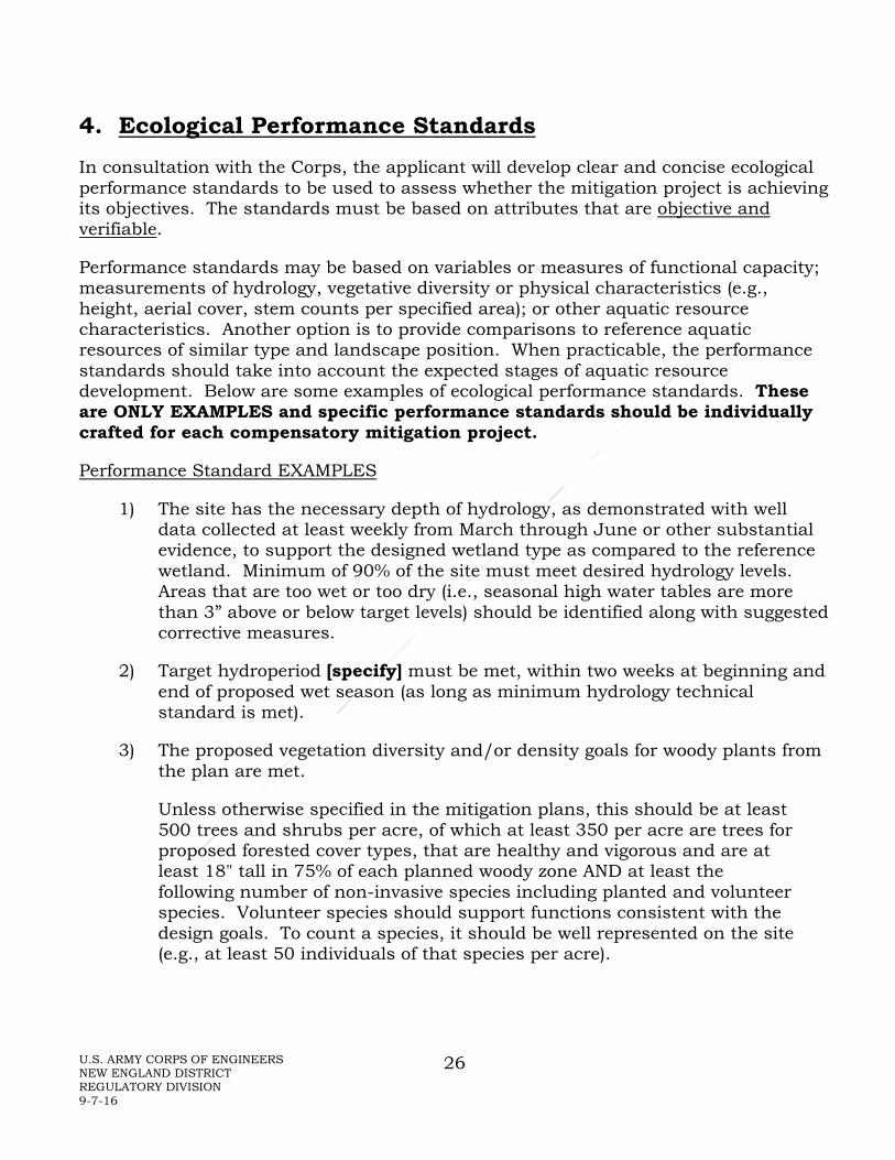
4. Ecological Performance Standards In consultation with the Corps, the applicant will develop clear and concise ecological performance standards to be used to assess whether the mitigation project is achieving its objectives. The standards must be based on attributes that are objective and verifiable.
Performance standards may be based on variables or measures of functional capacity; measurements of hydrology, vegetative diversity or physical characteristics (e.g., height, aerial cover, stem counts per specified area); or other aquatic resource characteristics. Another option is to provide comparisons to reference aquatic resources of similar type and landscape position. When practicable, the performance standards should take into account the expected stages of aquatic resource development. Below are some examples of ecological performance standards. These are ONLY EXAMPLES and specific performance standards should be individually crafted for each compensatory mitigation project.
Performance Standard EXAMPLES
1) The site has the necessary depth of hydrology, as demonstrated with well data collected at least weekly from March through June or other substantial evidence, to support the designed wetland type as compared to the reference wetland. Minimum of 90% of the site must meet desired hydrology levels. Areas that are too wet or too dry (i.e., seasonal high water tables are more than 3” above or below target levels) should be identified along with suggested corrective measures.
2) Target hydroperiod [specify] must be met, within two weeks at beginning and end of proposed wet season (as long as minimum hydrology technical standard is met).
3) The proposed vegetation diversity and/or density goals for woody plants from the plan are met.
Unless otherwise specified in the mitigation plans, this should be at least 500 trees and shrubs per acre, of which at least 350 per acre are trees for proposed forested cover types, that are healthy and vigorous and are at least 18" tall in 75% of each planned woody zone AND at least the following number of non-invasive species including planted and volunteer species. Volunteer species should support functions consistent with the design goals. To count a species, it should be well represented on the site (e.g., at least 50 individuals of that species per acre).

U.S. ARMY CORPS OF ENGINEERS NEW ENGLAND DISTRICT REGULATORY DIVISION 9-7-16
27
# species planted minimum # species required (volunteer and planted)
2 2 3 3 4 3 5 4 6 4 7 5 8 5 9 or more 6
Vegetative zones consist of areas proposed for various types of wetlands (shrub swamp, forested swamp, etc.). The performance standards for density can be assessed using either total inventory or quadrat sampling methods, depending upon the size and complexity of the site.
4) a. Each mitigation site shall have at least 95% areal cover, excluding planned open water areas or planned bare soil areas (such as for turtle nesting), by native species (See Appendix I).
b. Planned emergent areas on each mitigation site shall have at least 80% cover by non-invasive hydrophytes.
c. Planned scrub-shrub and forested cover types shall have at least 60% cover by non-invasive hydrophytes, including at least 15% cover by woody species.
For the purpose of this performance standard, invasive species of hydrophytes are:
• Cattails -- Typha latifolia, Typha angustifolia, Typha x glauca; • Common Reed -- Phragmites australis; • Purple Loosestrife -- Lythrum salicaria; • Reed Canary Grass -- Phalaris arundinacea; and • Glossy Buckthorn – Frangula alnus (= Rhamnus frangula). • [other species determined case-by-case]
5) Until canopy coverage exceeds 30%, the average height of all woody stems of tree species including volunteers in each site, must increase by not less than an average of 10% per year by the fifth (Year 5 following construction) and tenth (Year 10 following construction) monitoring years.
6) The fifth year (Year 5) and tenth year (Year 10) monitoring reports shall contain documentation that all vegetation within the buffer areas is healthy and thriving and the average tree height of all established and surviving trees is at least 5 feet in height.

U.S. ARMY CORPS OF ENGINEERS NEW ENGLAND DISTRICT REGULATORY DIVISION 9-7-16
28
7) There is evidence of expected natural colonization as documented by the presence of at least 100 volunteer native trees and/or shrubs at least 3 feet in height per acre.
8) The following plants are being controlled at the site:
• Common reed (Phragmites australis) • Purple loosestrife (Lythrum salicaria) • Glossy and Common buckthorns (Frangula alnus, Rhamnus cathartica) • Russian and Autumn olives (Elaeagnus angustifolia and E. umbellata) • Multiflora rose (Rosa multiflora) • Reed canary-grass (Phalaris arundinacea) • Japanese knotweed (Fallopia japonica) • [other species identified as a problem at the site]
For this standard, small patches must be eliminated during the entire monitoring period. Large patches must be aggressively treated and the treatment documented.
9) Site will have documented use by breeding populations of target species: [insert species]
10) Site will have documented use by target wildlife species: [insert species]
11) Site will have documented use by target macroinvertebrate species: [insert species]
12) Soil pH will be within target range of 6.2 – 6.8 for the site.
13) Soil has documented evidence of redoximorphic features developing by the third year (Year 3) after construction.
14) All slopes, soils, substrates, and constructed features within and adjacent to the mitigation site(s) are stable.
15) No nylon netting or non-biodegradable netting may be used in the mitigation area.
16) Replace culvert which severs aquatic connectivity with one complying with the Stream Crossing Standards. New culvert complies with all applicable Stream Crossing Standards and maintains compliance through the monitoring period.
17) 25 foot wide riparian zones on both sides of [specify] stream/river for [specify] linear feet will have >60% aerial coverage by native species by the

U.S. ARMY CORPS OF ENGINEERS NEW ENGLAND DISTRICT REGULATORY DIVISION 9-7-16
29
end of the first growing season, >85% by the end of the second growing season, and >95% by the end of the monitoring period.
18) Following dam removal, the footprint of the former dam is stable and continues to be stable through the monitoring period.
19) Formerly inundated areas are stable and have >95% aerial coverage by native vegetation.
20) Along the newly exposed stream channel, to ensure stream shading, banks have >95% aerial coverage with native woody species which are >5’ in height.

U.S. ARMY CORPS OF ENGINEERS NEW ENGLAND DISTRICT REGULATORY DIVISION 9-7-16
30
5. Monitoring A thorough monitoring plan is part of an adaptive management program that provides an early indication of potential problems and possible corrective actions and is used to determine if the project is meeting its performance standards. Monitoring of aquatic resource structure, processes, and function from the onset of restoration, creation, or rehabilitation can indicate potential problems. Process monitoring (e.g., water-level fluctuations, sediment accretion and erosion, plant flowering, and bird nesting) is particularly important because it may identify the source of a problem and remedial measures, as well as identifying functional development. Monitoring and control of invasive species must be a part of any effective adaptive management program. Assessment of aquatic resource performance must be integrated with adaptive management. Both require understanding the processes that drive the structure and characteristics of developing the desired aquatic resource. Simply documenting the structure (i.e., vegetation, sediments, fauna, and nutrients) will not provide the knowledge and guidance required to make adaptive “corrections” when adverse conditions are discovered. Although the full maturation of a compensatory aquatic resource may take many years or even decades, process-based monitoring facilitates adaptive management to insure that the mitigation site is developing along an appropriate trajectory.
Once the final mitigation plan is incorporated into a permit or approved for use in third party mitigation, full implementation of the mitigation plan will be required, including remedial measures, during the first five or more years (monitoring period) to ensure performance standards are met. Typically, sites proposed to be emergent-only wetlands or submerged aquatic vegetation will be monitored for five years and sites proposed to be scrub-shrub and/or forested wetlands or are comprised of invasive species removal will be monitored for five to ten years (years 1, 2, 3, 5, 7, and 10 if 10-year monitoring period), as extended periods for monitoring will be appropriate in some cases. Monitoring for other aquatic resources, such as streams and vernal pools, will be geared toward the specific mitigation activities, but will be for a minimum of five years as required by the Mitigation Rule. While formal monitoring and submission of reports may not be required every year, some remediation activities (e.g., invasive species control efforts) should continue.
Permit non-compliance or failure to meet a credit release schedule can include:
• failure to implement the plan and/or remedial measures • failure to achieve the designed aquatic resource types (HGM and/or Cowardin
for wetlands); • failure to submit copies of financial assurances and/or site protection
documents; • failure to submit required monitoring reports, transmittal, and self-certification
documents; and • failure to submit the final assessment document.

U.S. ARMY CORPS OF ENGINEERS NEW ENGLAND DISTRICT REGULATORY DIVISION 9-7-16
31
If all or part of the mitigation is still deemed not to meet performance standards at the end of the monitoring period, or recognized during the monitoring period as unlikely to ever meet performance standards, alternative mitigation must be developed to fully compensate for the authorized impacts.
Electronic submission of monitoring reports is strongly encouraged. Portable Document Format is preferred (e.g., Adobe PDF). When submitted in electronic format, there is no restriction for using standard paper sizes; however, monitoring report plans/data should be at the same scale as original permit mitigation drawings to allow for direct scale comparisons between mitigation plans and monitoring results. These monitoring reports should be concise and effectively provide the information necessary to assess the status of the compensatory mitigation project. Large, bulky reports containing general information are not necessary. The concise format for monitoring reports is included in Appendix D, Monitoring Report Requirements section. Additional monitoring guidance for specific habitat types is provided in several of the specific aquatic resource type modules in Appendices E-I.

U.S. ARMY CORPS OF ENGINEERS NEW ENGLAND DISTRICT REGULATORY DIVISION 9-7-16
32
6. Management
6.a. Site Protection
Appropriate real estate instruments providing long-term site protection include conservation easements (see 2.g.) held by third parties, generally government agencies with a conservation mission, or non-profit conservation organizations. If the site is on federal or state government land, long-term protection may be provided through facility management plans, integrated natural resources management plans, or other appropriate mechanisms that provide a reasonable degree of durability. The third party holder of the site protection instrument shall have the right to enforce site protections.
The site protection document shall prohibit incompatible uses that would jeopardize the objectives of the mitigation project.
The document must also contain a provision requiring 60-day advance notification to the Corps before any action is taken to void or modify the instrument, including transfer of title to or establishment of other legal claims to the site(s).
Real estate instruments, management plans, or other long-term protection must be approved by the Corps in advance of, or concurrent with, the authorized impacts.
6.b. Adaptive Management
Aquatic resource mitigation can be complicated and unforeseen outcomes can frequently occur. An adaptive management approach involves anticipating a variety of problems that might occur, exploring alternative ways to meet management objectives, predicting the outcomes of alternatives based on the current state of knowledge, implementing one or more of these alternatives, monitoring to learn about the impacts of management actions, and then using the results to update knowledge and adjust management actions (Williams et al., 2009). For example, pilot studies might compare various potential treatments to help determine the most effective mitigation approach. Such an approach requires detailed planning, effective implementation of the plan, close monitoring, adjusting to intermediate results, and making additional modifications when needed to reach the long-term goals.
If the project cannot be constructed substantially in accordance with the approved mitigation plan, the permittee must notify the Corps and obtain written approval for changes.
Should a site not meet the ecological performance objectives of the project, the Corps will work with the permittee to determine appropriate measures to remedy the deficiencies. This may include site modifications, design changes, revisions to maintenance requirements, revised monitoring requirements, or use of a different site. Performance standards may be revised in accordance with adaptive management to

U.S. ARMY CORPS OF ENGINEERS NEW ENGLAND DISTRICT REGULATORY DIVISION 9-7-16
33
account for measures taken to address deficiencies. They may also be revised to reflect changes in management strategies and objectives if the new standards provide ecological benefits that are comparable or superior to those originally approved. No other revisions to performance standards will be allowed except in the case of natural disasters.
6.c. Long-Term Management/Stewardship
Compensation sites are expected to mitigate impacts “in perpetuity.” Since monitoring has a limited timeframe, a willing entity must be found to receive responsibility for the mitigation site(s) associated with a permit or instrument. That entity must have the resources and expertise in the long-term management and stewardship of mitigation properties. The final mitigation plan must include a long-term management plan and should identify the party responsible for long-term management of the project. If, however, the mitigation provider is unable to designate the entity responsible for long-term management of the site at the time the mitigation plan (and its associated long-term management plan) are approved, future transfer of long-term management responsibility is acceptable after review and approval by the district engineer. In such cases, the mitigation provider is the default long-term manager until such time as the Corps approves transfer on long-term management responsibility to a third party.
The long-term management plan should include a description of possible long-term management needs (e.g., prevention of all-terrain vehicle problems, littering, encroachment, boat damage), the annual cost estimates to address them, and a funding mechanism to meet those needs. Long-term funding must be provided to the long-term site manager to provide the resources needed to manage the site per the terms of the long-term management plan and enforce the site protections. The entity taking on the responsibility for the long-term management of the site may not necessarily be the same entity responsible for the real estate instrument (e.g., the easement holder).
As noted in the Preamble to the Mitigation Rule (p.19648-9 in the 4/10/08 Federal Register) in the discussion about 33 CFR 332.7(d) Long-term management:
“Although compensatory mitigation projects should, to the extent it is practicable to do so, be self-sustaining, active long-term management and maintenance are often necessary for a compensatory mitigation project to fulfill its objectives. In such cases, provisions for long-term management need to be provided….
“For permittee responsible mitigation, § 332.7(d)(4) has been added to require approval of any required long-term financing mechanisms before the permitted impacts occur.
“…a long-term management plan should include a description of long-term management needs for the compensatory mitigation project and annual cost

U.S. ARMY CORPS OF ENGINEERS NEW ENGLAND DISTRICT REGULATORY DIVISION 9-7-16
34
estimates for those needs, and identify the funding mechanism that will support the long-term management activities.…
“In this rule, financial assurances are used to provide a high level of confidence that compensatory mitigation projects will be completed, whereas long-term management measures are used to help ensure the long-term sustainability of compensatory mitigation projects. Funding for financial assurances is handled differently than funding for long-term management. The final rule clearly differentiates between financial assurances for construction and establishment of compensatory mitigation projects and funding mechanisms for long-term management of those projects. In general, funding for long-term management should not be phased out over time, since those activities usually need to be conducted for substantial periods of time.”
Some examples of work that may be needed to be conducted by the long-term steward as part of long-term management include: annual walk-through of the property to check on condition of signage, gates, and/or fences; evidence of ATV damage; presence of invasive species; unauthorized camping; evidence of dumping of trash, yard waste, etc.; and associated costs to address these (or other) issues.
To ensure the long-term management entity has adequate funding to do annual inspections, perform needed maintenance, and deal with problems, a financing mechanism (e.g., endowment, trust, or long-term financing plan for a public entity) should be provided. If an endowment is used, it should be sufficient that the needed stewardship activities can be covered by around 3% of the principal. This should generally allow the principal to continue to grow and cover inflation. The long-term steward/manager and the particulars of the endowment should be included in the mitigation plan and may also be included as a special permit condition or requirement for credit release.

U.S. ARMY CORPS OF ENGINEERS NEW ENGLAND DISTRICT REGULATORY DIVISION 9-7-16
35
APPENDIX A – GLOSSARY These definitions are for use with this document. Somewhat different definitions may exist in other sources.
Active channel: The part of a non-tidal stream system within which natural processes maintain a linear depression for water flow, typically characterized by the presence of a bed and bank. The boundary of the active channel is the stream feature which most closely meets the criteria of the Ordinary High Water Mark (Mersel et al., 2014). This applies to all streams, whether or not they have been created and/or modified. For tidal streams the boundary would be the high tide line.
Belt width (or meander belt width): Width of the corridor as defined by the lateral extent of the river meanders. It is governed by valley landforms, surficial geology, and the length and slope requirements of the river channel. (VT ANR River Corridor Protection Guide).
Buffer: An area along an aquatic resource that protects that resource from adverse impacts of nearby land uses. It may intercept pollution, provide a wildlife corridor, supply shade to a waterway, stabilize sediments, reduce noise, provide habitat required by some aquatic species, etc. When located along a waterway it is termed a riparian buffer (see additional information in Appendix G - Stream Module).
Compensatory mitigation: Action taken which provides some form of substitute aquatic resource for the impacted aquatic resource after all appropriate and practicable avoidance and minimization has been achieved. It may include created, restored, and/or rehabilitated wetlands, streams, mudflats, etc. and preserved wetlands, streams, and/or uplands provided by the permittee or a third party through a mitigation bank or ILF program.
Credit: A unit of measure (e.g., a functional or areal measure or other suitable metric) representing the accrual or attainment of aquatic functions at a compensatory mitigation site. The measure of aquatic functions is based on the resources restored, established, enhanced, or preserved. [33 CFR 332.2]
Cultivars: Non-native species or varieties which are developed for cultivation (e.g., agriculture, landscaping).
Debit: A unit of measure (e.g., a functional or areal measure or other suitable metric) representing the loss of aquatic functions at an impact or project site. The measure of aquatic functions is based on the resources impacted by the authorized activity. [33 CFR 332.2]

U.S. ARMY CORPS OF ENGINEERS NEW ENGLAND DISTRICT REGULATORY DIVISION 9-7-16
36
Eelgrass rehabilitation: Restoring degraded functions of an existing eelgrass habitat. Degradation may result from infestation by herbivores, decreased water quality, or a change in substrate composition. Eelgrass habitat rehabilitation does not result in a gain in vegetated aquatic resource acreage.
Eelgrass habitat creation: The transformation of subtidal habitat to eelgrass beds at a site where it did not previously exist, so far as is known. It is sometimes referred to as “establishment.” Eelgrass bed creation results in a gain in vegetated aquatic resource acreage.
Eelgrass restoration: Returning a former eelgrass habitat area, which had been altered or disturbed to the extent that it was no longer functioning as eelgrass habitat, to viable eelgrass habitat. It is sometimes referred to as “re-establishment.” Eelgrass restoration results in a gain in vegetated aquatic resource acreage.
Embayment: Portions of marine/estuarine open water or marsh defined by natural topographical features such as points or islands, or by human structures such as dikes or channels. It is assumed that these semi-enclosed basins, due to their sheltered nature, provide a preferred growing environment for submerged aquatic vegetation (SAV), such as eelgrass.
Enhancement: The manipulation of the physical, chemical, or biological characteristics of an aquatic resource to heighten, intensify, or improve a specific aquatic resource function(s). Enhancement results in the gain of selected aquatic resource function(s), but may also lead to a decline in other aquatic resource function(s). Enhancement does not result in a gain in aquatic resource area. In this current sense, this is NOT the same as rehabilitation.
Ephemeral stream: A stream with a channel that is above the water table at all times and carries water only during and immediately after a rain event (from Stream Visual Assessment Protocol; SVAP2).
Epibiont (in the context of SAV): A plant or animal (e.g., macroalgae or colonial tunicates) that grows on the surface of another plant, usually for the purposes of physical support and exposure to currents that enhance nutrient exchange.
Establishment (creation): The manipulation of the physical, chemical, or biological characteristics present to develop an aquatic resource that did not previously exist at an upland site. Establishment results in a gain in aquatic resource area and functions. This is equivalent to the traditional use of the term “creation.”
Exotic species: Used in this context, the same as non-native species - species not native to New England, and usually not native to North America.
Herbivore: Any animal that primarily feeds on living plants.
U.S. ARMY CORPS OF ENGINEERS NEW ENGLAND DISTRICT REGULATORY DIVISION 9-7-16
37
Hydrogeomorphic (HGM) Classification: A Hydrogeomorphic wetland classification system based on geomorphic position and hydrologic characteristics used to classify wetlands into seven different wetland classes, as defined by Brinson (1993) and Smith et al. (1995).
Hydroperiod: Timing, frequency, and duration of seasonal inundation and drying in a typical year.
In-lieu fee (ILF) program: A program involving the restoration, establishment, rehabilitation, and/or preservation of aquatic resources through funds paid to a governmental or non-profit natural resources management entity to satisfy compensatory mitigation requirements for Corps permits. Similar to a mitigation bank, an ILF program sells compensatory mitigation credits to permittees whose obligation to provide compensatory mitigation is then transferred to the ILF program sponsor. However, the rules governing the operation and use of ILF programs are somewhat different from the rules governing operation and use of mitigation banks. The operation and use of an ILF program are governed by an ILF program instrument. [33 CFR 332.2]
Intermittent stream: A stream that flows only certain times of the year, such as when it receives water from springs, ground water, or surface runoff (from Stream Visual Assessment Protocol; SVAP2).
Invasive species: Native and non-native species which aggressively invade areas, especially areas that are altered or disturbed, and displace less competitive native species. This often results in a near monoculture of the invasive species.
Metamorph: Name for a young amphibian that has just completed, or is close to completing metamorphosis to another life history stage. Metamorphosis is the process of growth and development of an amphibian (or other animal) from an egg through larval stages to become an adult.
Mitigation bank: A site, or suite of sites, where aquatic resources (e.g., wetlands, streams, riparian areas) are restored, established, rehabilitated, and/or preserved for the purpose of providing compensatory mitigation for impacts authorized by Corps permits. In general, a mitigation bank sells compensatory mitigation credits to permittees whose obligation to provide compensatory mitigation is then transferred to the mitigation bank sponsor. The operation and use of a mitigation bank are governed by a mitigation banking instrument. [33 CFR 332.2]
Mitigation (in relation to S.404): While federal mitigation includes sequencing from avoidance to minimization to, finally, compensation, the term is used in this document as the equivalent of “compensation.”
U.S. ARMY CORPS OF ENGINEERS NEW ENGLAND DISTRICT REGULATORY DIVISION 9-7-16
38
Ordinary High Water Mark (OHWM): “A line on the shore established by the fluctuations of water and indicated by physical characteristics such as a clear, natural line impressed on the bank, shelving, changes in the character of soil, destruction of terrestrial vegetation, or the presence of litter and debris.” (33 CFR 328.3(e)) It is the defining element for identifying the lateral limits of non-wetland waters.
Preservation: The removal of a threat to, or preventing the decline of, aquatic resources by an action in or near those aquatic resources. This term includes activities commonly associated with the protection and maintenance of aquatic resources through the implementation of appropriate legal and physical mechanisms. Preservation does not result in a gain of aquatic resource area or functions.
Reach: A section of stream. When using the Stream Visual Assessment Protocol a reach is a section of stream with consistent characteristics. (See Stream Visual Assessment Protocol; SVAP2.
Re-establishment (restoration): The manipulation of the physical, chemical, or biological characteristics of a site with the goal of returning natural/ historic functions to a former aquatic resource. Re-establishment results in rebuilding a former aquatic resource and results in a gain in aquatic resource area and functions. This results in a restoration of area and functions. This is equivalent to the traditional use of the term “restoration.”
Reference vernal pool: A minimally degraded vernal pool that is representative of expected ecological conditions. Reference pools serve as a standard for determining the health and integrity of other vernal pools in the same regional geomorphic setting. For geomorphic settings of vernal pools in the northeast, see Rheinhardt and Hollands (2008).
Rehabilitation: The manipulation of the physical, chemical, or biological characteristics of a site with the goal of repairing natural/historic functions to a degraded aquatic resource. Rehabilitation results in a gain in aquatic resource function, but does not result in a gain in aquatic resource area. This results in a restoration of functions to a degraded aquatic resource. Degradation may result from infestation by invasive species, partial filling that does not create upland, deliberate removal of woody species (natural changes such as flooding and subsequent demise of trees as a result of beaver activity is not degradation), partial draining, etc. Rehabilitation differs from enhancement in that rehabilitation is intended to result in a general improvement in the suite of the functions typically performed by an unaltered reference aquatic resource. In contrast, enhancement activities often focus on increasing one or two functions, rather than improving the suite of functions being performed by an existing aquatic resource. Wetlands rehabilitation does not result in a gain in wetland acreage.

U.S. ARMY CORPS OF ENGINEERS NEW ENGLAND DISTRICT REGULATORY DIVISION 9-7-16
39
Restoration: The manipulation of the physical, chemical, or biological characteristics of a site with the goal of returning natural/historic functions to a former or degraded aquatic resource. For the purpose of tracking net gains in aquatic resource area, restoration is divided into two categories: re-establishment (which results in a net gain in aquatic resource area) and rehabilitation (which does not result in a net gain in aquatic resource area). The traditional use of the term is equivalent to reestablishment.
Secondary impacts: Effects on an aquatic ecosystem that are associated with a discharge of dredged or fill materials, but do not result from the actual placement of the dredged or fill material (40 CFR 230.11(h)).
Stream: Unidirectionally flowing waters and their channels, which include rivers, brooks, creeks, branches, tributaries, and headwater streams. They may be periodically or seasonally non-flowing (intermittent or ephemeral) or continuously flowing (perennial).
Target species: The target species is/are the species used to help define the mitigation plan habitat goals. It may be appropriate to design different parts of the plan to address each target species’ habitat requirements, for example multiple pools with different hydroperiods.
Temporal loss: The time lag between the loss of aquatic resource FUNCTIONS caused by the permitted impacts and the fully functional replacement of aquatic resource functions at the compensatory mitigation site(s) (33 CFR 332.2).
Vernal pool: Vernal pools are depressional aquatic resource basins that typically go dry in most years and may contain inlets or outlets, typically of intermittent flow. Vernal pools range in both size and depth depending upon landscape position and parent material(s). Pools usually support one or more indicator species, including: wood frog, spotted salamander, blue-spotted salamander, marbled salamander, Jefferson’s salamander, and fairy shrimp; however, they should preclude sustainable populations of predatory fish.
Vernal pool breeding season: For the purposes of this document, the breeding season refers to the entire period of time necessary to complete the amphibian cycle from egg-laying through metamorphosis and emergence from the pool. The breeding season may vary regionally and annually, but generally begins between early to mid-March (southern New England) and mid to late April (northern Maine). The breeding season ends when the pool dries out, usually by early summer. It should be noted that, in areas inhabited by marbled salamander (a fall breeder), breeding season observations should also be made in the fall (September to October).
Vernal pool critical terrestrial habitat: This is the area from 100 to 750 feet of the vernal pool’s edge. The critical terrestrial habitat typically extends 750 feet from the

U.S. ARMY CORPS OF ENGINEERS NEW ENGLAND DISTRICT REGULATORY DIVISION 9-7-16
40
vernal pool edge or 650 feet from the vernal pool envelope’s outer edge and refers to the area outside of the breeding pool that supports the non-larval life-cycle stages of pool-breeding amphibian species. See Calhoun and deMaynadier 2008.
Vernal pool edge: The outer boundary of a vernal pool, determined by the maximum observed or recorded extent of inundation. The boundary may be defined by a distinct topographic break in slope or by evidence of high water marks or other appropriate physical data.
Vernal pool directional buffer: An area that links critical habitats used by pool-breeding amphibians by incorporating migration corridors between post-breeding and breeding habitat, defined by portions of the vernal pool envelope, vernal pool critical terrestrial habitat, and connections between the two.
Vernal pool envelope: The area from the edge of the vernal pool to 100 feet outward. The edge defines the inner boundary of the envelope; the outer boundary is located 100 feet outward from the edge. See Calhoun and deMaynadier 2008.
Vernal pool facultative species: Vertebrate and invertebrate species that frequently use vernal pools for at least a portion of their life cycle, but that normally meet other life cycle requirements in other types of waters, including wetlands.
Vernal pool indicator species: Vertebrate and invertebrate species that depend upon vernal pool habitat for meeting all or a critical portion of their life cycle requirements. These species serve as direct evidence of the presence of a vernal pool. They may also be referred to as obligate or vernal pool-dependent species.
Vernal pool life zone: The combined area of the vernal pool envelope and vernal pool critical habitat area.
Watershed: A land area that drains to a common waterway, such as a stream, lake, estuary, wetland, or ultimately the ocean.
Watershed approach: An analytical process for making compensatory mitigation decisions that support the sustainability or improvement of aquatic resources in a watershed. It involves consideration of watershed needs, and how locations and types of compensatory mitigation projects address those needs. A landscape perspective is used to identify the types and locations of compensatory mitigation projects that will benefit the watershed and offset losses of aquatic resource functions and services caused by activities authorized by DA permits. The watershed approach may involve consideration of landscape scale, historic and potential aquatic resource conditions, past and projected aquatic resource impacts in the watershed, and terrestrial connections between aquatic resources when determining compensatory mitigation requirements for DA permits.

U.S. ARMY CORPS OF ENGINEERS NEW ENGLAND DISTRICT REGULATORY DIVISION 9-7-16
41
Watershed plan: A plan developed by federal, tribal, state, and/ or local government agencies or appropriate non-governmental organizations, in consultation with relevant stakeholders, for the specific goal of aquatic resource restoration, establishment, enhancement, and preservation. A watershed plan addresses aquatic resource conditions in the watershed, multiple stakeholder interests, and land uses. Watershed plans may also identify priority sites for aquatic resource restoration and protection. Examples of watershed plans include special area management plans, advance identification programs, and wetland management plans.
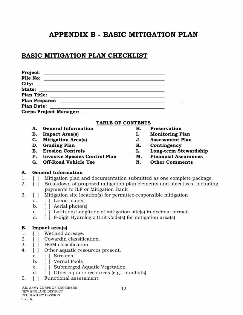
U.S. ARMY CORPS OF ENGINEERS NEW ENGLAND DISTRICT REGULATORY DIVISION 9-7-16
42
APPENDIX B - BASIC MITIGATION PLAN BASIC MITIGATION PLAN CHECKLIST
Project: File No: City: State: Plan Title: Plan Preparer: Plan Date: Corps Project Manager:
TABLE OF CONTENTS A. General Information H. Preservation B. Impact Area(s) I. Monitoring Plan C. Mitigation Area(s) J. Assessment Plan D. Grading Plan K. Contingency E. Erosion Controls L. Long-term Stewardship F. Invasive Species Control Plan M. Financial Assurances G. Off-Road Vehicle Use N. Other Comments
A. General Information 1. [ ] Mitigation plan and documentation submitted as one complete package. 2. [ ] Breakdown of proposed mitigation plan elements and objectives, including
payments to ILF or Mitigation Bank 3. [ ] Mitigation site location(s) for permittee-responsible mitigation
a. [ ] Locus map(s) b. [ ] Aerial photo(s) c. [ ] Latitude/Longitude of mitigation site(s) in decimal format. d. [ ] 8-digit Hydrologic Unit Code(s) for mitigation area(s)
B. Impact area(s) 1. [ ] Wetland acreage. 2. [ ] Cowardin classification. 3. [ ] HGM classification. 4. [ ] Other aquatic resources present.
a. [ ] Streams b. [ ] Vernal Pools c. [ ] Submerged Aquatic Vegetation d. [ ] Other aquatic resources (e.g., mudflats)
5. [ ] Functional assessment.

U.S. ARMY CORPS OF ENGINEERS NEW ENGLAND DISTRICT REGULATORY DIVISION 9-7-16
43
6. [ ] Work proposed. 7. [ ] Watershed or regional plans. 8. [ ] 8-digit Hydrologic Unit Code(s).
C. Mitigation area(s) 1. Mitigation alternatives 2. Mitigation background
a. [ ] Existing wildlife use. b. [ ] Existing soil. c. [ ] Existing vegetation. d. [ ] Surrounding land uses. e. [ ] USFWS and/or NOAA Clearance Letter or Biological Opinion. f. [ ] SHPO/THPO Cultural Resource Clearance Letter.
3. Mitigation proposed
a. [ ] Wetland acreage proposed at each site. b. [ ] Cowardin classifications proposed at each site. c. [ ] HGM classifications proposed at each site. d. [ ] Other aquatic resources proposed at each site.
i. [ ] Streams ii. [ ] Vernal Pools iii. [ ] Submerged Aquatic Vegetation iv. [ ] Other aquatic resources (e.g., mudflats)
e. [ ] Functions and values proposed. f. [ ] Target fish and/or wildlife species. g. [ ] Reference site(s). h. [ ] Design Constraints. i. [ ] Construction oversight. j. [ ] Project construction timing. k. [ ] Responsible parties for all aspects of project. l. [ ] FAA concerns.
4. Specific Aquatic Resource Checklist Information Appended a. [ ] Wetlands b. [ ] Streams c. [ ] Vernal Pools d. [ ] Submerged aquatic vegetation e. [ ] Other aquatic resources (e.g., mudflats)
D. Grading Plan 1. [ ] Plan View
a. [ ] Existing and proposed grading plans. b. [ ] Microtopography c. [ ] Appropriate scale. d. [ ] Appropriate size and format. e. [ ] Scale bar.

U.S. ARMY CORPS OF ENGINEERS NEW ENGLAND DISTRICT REGULATORY DIVISION 9-7-16
44
f. [ ] Site access. 2. [ ] Representative cross-sections. 3. [ ] Other.
E. Erosion Controls [ ] Removal deadline.
F. Invasive Species Control Plan 1. [ ] Risks. 2. [ ] Constraints. 3. [ ] Control strategy.
G. Off-Road Vehicle Use 1. [ ] Current usage. 2. [ ] Control plan.
H. Site Protection 1. [ ] Adequate buffers. 2. [ ] Protection of wetlands. 3. [ ] Required preservation language. 4. [ ] Plans of preservation area(s). 5. [ ] Legal documentation. 6. [ ] Documentation of acceptance by receiving agency (if applicable).
I. Monitoring and Assessment 1. [ ] Monitoring Plan. 2. [ ] Transmittal and Self-Certification Form. 3. [ ] Project Overview Form. 4. [ ] An appropriate final assessment is proposed and language is included.
J. Contingency [ ] Contingency plan.
K. Long-term Stewardship 1. [ ] Long-term stewardship plan. 2. [ ] Legal documentation.
L. Financial Assurances [ ] Financial assurances are included.
M. Other Comments

U.S. ARMY CORPS OF ENGINEERS NEW ENGLAND DISTRICT REGULATORY DIVISION 9-7-16
45
BASIC MITIGATION PLAN CHECKLIST DIRECTIONS
TABLE OF CONTENTS A. General Information B. Impact Area(s) C. Mitigation Area(s) D. Grading Plans E. Erosion Controls F. Invasive Species G. Off-Road Vehicle Use
H. Preservation I. Monitoring J. Assessment K. Contingency L. Long Term Stewardship M. Financial Assurances N. Other Comments
All checklist items should be included in the mitigation plan or there should be an explanation as to why they are not appropriate. While most of these items will be needed for most mitigation plans, a few items included here will need to be modified for specific resource types (see following guidance).
After Corps review, items not marked with X (included), N/A (Not Applicable), or NONE should be addressed by the applicant, as well as any comments under any item.
The used throughout this document indicates text which should typically be included in the mitigation plan.
Many items on the checklist are self-explanatory. Those which require it have specific guidance or clarification. Basic project information as noted in the main portion of the checklist should be included in every mitigation plan. Information noted in specific resource modules should be submitted for any project which includes mitigation involving the specific resource(s), e.g., nontidal wetlands, vernal pools, SAV, etc.
A. GENERAL INFORMATION
1. To avoid confusion, all mitigation proposal materials should be submitted as a single package without extraneous information that is needed for the permit evaluation but is not pertinent to the mitigation itself. A complete mitigation plan is important so that it may be cited in the permit and be easily used for permit compliance.
2. Fully identify, in detail, all elements of the proposed mitigation, including any payments into an ILF Program or purchase of credits from a Mitigation Bank (Note that, if permittee-responsible mitigation is proposed, a rationale for not using a bank or ILF program should be provided.) If all impacts are proposed to be covered by an ILF Program and/or Mitigation Bank, move on to section B, do not complete section A.3. or sections C-M. For any permittee-responsible mitigation complete all sections of the checklist.
U.S. ARMY CORPS OF ENGINEERS NEW ENGLAND DISTRICT REGULATORY DIVISION 9-7-16
46
3a. Locus maps that show the location of the impact area and the location of all permittee-responsible mitigation sites – including preservation areas – are critical components of the plan. They should depict the geographic relationship between the impacted site(s) and the proposed mitigation site(s) and include a vicinity map of approximately 1 inch equals 2,000 feet. For sites where the relationship between the impacted site(s) and proposed mitigation site(s) is not clear at USGS quadrangle scale, an additional plan should be provided at an appropriate scale.
3b. Aerial photographs, if available, should be included. There are several on-line sources available. Recent photographs are preferred.
3c. Longitude and latitude of the mitigation site(s), including preservation areas, should be given in decimal format, rather than degrees and minutes or UTMs.
3d. Watershed(s) must be identified using the USGS 8-digit Hydrologic Unit Code(s) for each proposed mitigation site (See Item A.2 on the Checklist), including preservation sites. One source of these codes is an EPA’s “Surf your Watershed” website.
B. IMPACT AREA(S)
Complete items B.1 – B.8 for EACH impact site. Impact areas include both wetlands and waters. Most of the checklist items are self-explanatory but clarification is provided for stream information, functions and values assessment, and watershed plans.
1. Total acreage of wetlands and/or waters at each impact site should be reported. See also Item B.4. for special resource types.
2. For each site, describe the resources using Cowardin, et al.5 1979 and Tiner 20146 and tabulate total acreage for each wetland class (e.g. PFO1, PSS, PEM)
3. Wetlands at each site should also be described using the hydrogeomorphic7 classification system and total acreage should be calculated for each HGM class.
4a. If the impact area contains any streams, the Stream Checklist (see Appendix F – Stream Module) must be included. Descriptions of any streams that will be impacted, should include length of stream to be impacted, nature of banks, normal seasonal flows, gradient, sinuosity, bed load, lengths of riffles and pools, and adjacent
5 Cowardin, et. al. (1979) “Classification of wetlands and deepwater habitats of the United States,” Office of Biological Services, FWS/OBS-79/31, December 1979 6 Tiner, R.W. 2014. Dichotomous Keys and Mapping Codes for Wetland Landscape Position, Landform, Water Flow Path, and Waterbody Type Descriptors: Version 3.0. U.S. Fish and Wildlife Service, National Wetlands Inventory Program, Northeast Region, Hadley, MA. 65 pp. 7 Brinson, M. M. (1993). "A hydrogeomorphic classification for wetlands," Technical Report WRP-DE-4, U.S. Army Engineer Waterways Experiment Station, Vicksburg, MS. NTIS No. AD A270 053.

U.S. ARMY CORPS OF ENGINEERS NEW ENGLAND DISTRICT REGULATORY DIVISION 9-7-16
47
landscape. Completed Stream Visual Assessment Protocol Worksheet is provided per SVAP2.
4b. If the impact area contains any vernal pools, the Vernal Pool Checklist (see Appendix G – Vernal Pool Module) must be included. Descriptions of any vernal pool(s) on site should be documented using the Corps’ Vernal Pool Characterization Form (see Appendix L) or similar approved form.
4c. If the impact area includes any SAV, the SAV Checklist (see Appendix H – SAV Module) must be included. Describe variability and extent of bed size for any SAV on-site.
4d. Describe the extent and location of any other aquatic resources (e.g., mudflats) on-site.
5. Describe both site specific and landscape level wetland and stream functions and services at each impact site. Functional assessment methods should be approved by the Corps in advance and must have adequate levels of detail (e.g., simply stating “wildlife habitat” or “fishery habitat” is inadequate. Additional information needs to be provided. Provide indicator species for the habitat type such as forest-dwelling migratory birds or mole salamanders and/or wood frogs for a vernal pool). The more specific the information, the more confidence the Corps will have in the evaluation.
6. Describe type and purpose of work at each impact site.
7. Relationship of impact area(s) to watershed or regional plans for the area discussed. Watershed and/or regional plans that describe aquatic resource objectives should be discussed if such plans are available for the impact area(s). If no such plans exist, this should be stated.
8. Watershed(s) must be identified using the USGS 8-digit Hydrologic Unit Code(s) for each impact site. One source of these codes is on EPA’s “Surf your Watershed” website.
C. MITIGATION AREA(S)
1. Provide an explanation of sites and methodologies considered for mitigation activities and the rationale for selection or rejection. The Mitigation Rule discusses when use of a potential mitigation site is practicable, whether on-site or off-site mitigation is appropriate, and whether out-of-kind mitigation is appropriate instead of in-kind. In order to replace the impacted functions, in-kind mitigation is generally preferred unless the impacted site is heavily degraded, or potential exists to restore a historically extant but now regionally rare wetland type, e.g., an Atlantic white cedar swamp or circumboreal spruce-fir wetland.
2a. Describe the sites existing wildlife usage, including information on any probable state and federal threatened and endangered species habitat.

U.S. ARMY CORPS OF ENGINEERS NEW ENGLAND DISTRICT REGULATORY DIVISION 9-7-16
48
2b. Subsurface soil conditions have a critical role in mitigation design, whether the substrate is sand, loam, silt, clay, and/or bedrock. Therefore, soil profiles should be provided that extend down to at least two feet below the proposed new soil surface. Since much of New England has been and continues to be heavily developed, there is a potential for industrial and agricultural contaminants in the soil. Although contamination does not necessarily preclude the use of a site, testing that is commensurate with the risk may be needed.
2c. Describe the existing vegetation on the site including a list of species, dominant species, density, community types, and community structure.
2d. Surrounding land use should be described within at least 500 feet of the site(s) and include a discussion of likely future land uses. Include a discussion of how the site(s) plans fit into the watershed context and the proximity of the site to public and private protected lands.
2e. USFWS and/or NOAA Clearance Letter or Biological Opinion is for the mitigation site(s) and necessary to ensure that threatened or endangered species will not be impacted by the mitigation. This is not necessarily addressed in those agencies’ comments on the proposed project that requires the mitigation.
2f. SHPO/THPO letters on the proposed project also may not address potential concerns at the mitigation site, so evidence of coordination with these parties concerning possible effects to historic properties must be provided for the mitigation site(s).
3a. – c. Similar information is required for the mitigation area(s) as for the impacted area(s). Along with mitigation acreage at each site, the type of mitigation (i.e., creation, restoration, rehabilitation, preservation) should be identified. A single mitigation site may not be able to provide the full range of functions desired because some functions are incompatible. For example, some wildlife habitat may not be compatible with flood storage.
3d. Check any other aquatic resources proposed at each site.
3e. Site-specific and landscape-level functions and values proposed at each site.
3f. Identify fish and/or wildlife species that are planned for the site.
3g. Identify any reference sites that are used.
3h. Frequently mitigation designs are constrained by the project itself, landscape features, or public issues that control or otherwise influence the design and/or monitoring and remediation of the mitigation area. Such constraints need to be explained in detail. If there are no constraints (rare), that should be stated in the plan.

U.S. ARMY CORPS OF ENGINEERS NEW ENGLAND DISTRICT REGULATORY DIVISION 9-7-16
49
3i. To ensure that someone with expertise in the specific aquatic resource(s) being mitigated provides construction oversight for the mitigation project, the following language should be included in the narrative portion of the mitigation plan:
A wetland scientist/coastal habitat scientist/stream scientist [choose appropriate for project] shall be on-site to monitor construction of the mitigation area(s) to ensure compliance with the mitigation plan and to make adjustments when appropriate to meet mitigation goals.
3j. Construction timing of the mitigation and the proposed aquatic resource impacts affects temporal impacts. Therefore, the following language should be included in the narrative portion of the mitigation plan:
Compensatory mitigation shall be initiated not later than 90 days after initiation of project construction and completed within [specify time period] of commencement of mitigation construction.
3k. All parties responsible for the implementation, performance, and long-term management of the mitigation project must be identified.
3l. Discuss potential to attract waterfowl and other bird species that might pose a threat to aircraft. Wildlife can pose serious threats to aircraft and therefore mitigation sites near airports are of concern to the Federal Aviation Administration. Indicate how far the nearest airport is from the site. See Federal Aviation Administration Advisory Circular AC No: 150/5200-33B Hazardous Wildlife Attractants on or Near Airports, 8/28/2007.
4a. – e. Identify which specific aquatic resource checklist(s) are included (See Appendices E – I).
D. GRADING PLANS
1a. Plan provides existing and proposed grading plans for mitigation area. Existing contours should be no greater than 2’ intervals. Proposed contours should be to 1’ intervals (some situations such as salt marsh restoration will require finer intervals) in the wetlands portion of the mitigation with spot elevations for intermediate elevations. All other areas should be shown at 2’ contour intervals.
1b. Where microtopographic variation is planned, the proposed maximum differences in elevation should be specified. The plan does not need to show the locations of each pit and mound as long as a typical cross-section and approximate number of pits and mounds is given for each zone.
1c. Scale is in the range of 1”=20’ to 1”=100’
1d. All items on the plan are legible. Electronic documents are encouraged (e.g., PDF); otherwise plans should be on 8 ½ x 11” sheets. Plans should be in black and white on

U.S. ARMY CORPS OF ENGINEERS NEW ENGLAND DISTRICT REGULATORY DIVISION 9-7-16
50
8 ½ x 11” sheets. Large format sheets are encouraged for clarity, but only as a supplement to the letter-sized sheets. Color reproductions of large format sheets should also be submitted in electronic form but should not be part of the formal plan as the color is lost during digitization of files.
1e. Plans have a bar scale.
1f. The drawings should show the access for maintenance and monitoring.
2. Plan provides representative cross sections showing the existing and proposed grading plan, expected range of shallow groundwater table elevations or surface water level consistently expected. Cross-sections should include key features such as non-wetland islands and pools and should extend beyond the mitigation site into adjacent wetlands and non-wetlands.
3. Specific staff recommendations related to grading.
E. EROSION CONTROLS
Erosion control removal deadline is included. The following language is included in the mitigation plan, either in the drawings or in the narrative portion of the plan:
Temporary devices and structures to control erosion and sedimentation in and around mitigation sites shall be properly maintained at all times. The devices and structures shall be disassembled and properly disposed of as soon as the site is stable but no later than November 1st of the third full growing period after planting. Sediment collected by these devices will be removed and placed upland in a manner that prevents its erosion and transport to a waterway or wetland.
F. INVASIVE AND NON-NATIVE SPECIES
The mitigation plan must include an Invasive Species Control Plan (ISCP).
1. The discussion of risk should include evaluation of the potential for invasion of the wetland by unwanted species or varieties, such as Common reed (Phragmites australis), Purple loosestrife (Lythrum salicaria), Smooth and Common buckthorns (Frangula alnus and Rhamnus cathartica), Russian and Autumn olives (Elaeagnus angustifolia and E. umbellata), Multiflora rose (Rosa multiflora), Reed canary-grass (Phalaris arundinacea), Japanese knotweed (Fallopia japonica), or other identified problematic species specific to this project or site.
2. The plan should identify regulatory and ecological constraints that influence the design of any plan to control invasive plants and animals by biological, mechanical, or chemical measures. For example, if a state requires a permit for use of herbicide, this may constrain attempts to control an invasive plant species. If there are no constraints, this should be stated.
U.S. ARMY CORPS OF ENGINEERS NEW ENGLAND DISTRICT REGULATORY DIVISION 9-7-16
51
3. The plan should describe the strategy to control, or recognize and respond to, the degradation of the mitigation site by invasive or non-native plants, particularly those listed in item F1. above. Addresses a scope commensurate with risk & constraints.
G. OFF-ROAD VEHICLE USE
1. Describe current usage including snowmobile usage and address control measures. If there is no off-road vehicle use in immediate vicinity please note this.
2. If there is a potential for off-road vehicle access at the site, including snowmobile usage, the mitigation plan shall include a strategy to minimize impacts. Plans should illustrate locations of any necessary barriers placed at access points to the mitigation sites to prevent vehicles from damaging the sites.
H. SITE PROTECTION
1. Adequate buffers must be proposed to protect the ecological integrity of creation, restoration, and/or rehabilitated areas.
2. Wetlands within subdivisions, golf courses, etc. should generally be protected along with adequate buffers. This is part of the avoidance and minimization steps of mitigation, not part of compensation.
3. Site protection should be part of every mitigation package as preservation of a creation, restoration, or rehabilitated area, and buffer; the remaining unimpacted aquatic resources on-site as part of avoidance and minimization; as a stand-alone form of mitigation; or as any combination of these. Ideally the preservation document will be prepared, then reviewed and approved by the Corps prior to submission of the final mitigation plan and permit issuance. If this is not possible, the following language should be included in the plan8:
Compensatory mitigation sites and remaining on-site aquatic resources (and buffers) to be set aside for conservation shall be protected in perpetuity from future development. Within 90 days of the date this permit is issued and prior to initiation of permitted work in aquatic resources, the permittee shall submit to the Corps of Engineers a draft of the conservation easement or deed restriction. Within 30 days of the date the Corps approves this draft document in writing, the permittee shall execute and record it with the Registry of Deeds for the Town of ___________ and the State of __________. A copy of the executed and recorded document must then be sent to the Corps of Engineers within 120 days of the date the Corps approves it. The conservation easement or deed restriction shall enable the site or sites to be protected in perpetuity from any future development. For preservation as part of compensation, the
8 Departments of Transportation, in particular, may need to have the timing requirements modified. This will be addressed on a case-by-case basis.
U.S. ARMY CORPS OF ENGINEERS NEW ENGLAND DISTRICT REGULATORY DIVISION 9-7-16
52
conservation easement or deed restriction shall expressly allow for the creation, restoration, remediation and monitoring activities required by this permit on the site or sites. It shall prohibit all other filling, clearing and other disturbances (including vehicle access) on these sites except for activities explicitly authorized by the Corps of Engineers in these approved documents.
If it is possible to have the document prepared and approved prior to final mitigation plan submission and permit issuance, only the following needs to be included:
Within 30 days of the date of permit issuance and prior to initiation of permitted work in aquatic resources, the permittee shall execute and record the preservation document with the Registry of Deeds for the Town of -___________ and the State of __________. A copy of the executed and recorded document must then be sent to the Corps of Engineers within 120 days of the date the Corps approves it.
4. Plans showing the location of all sites to be preserved are required. In addition to a locus, they must be sufficiently detailed to determine relationships to adjacent development and/or properties as these adjacent areas affect the long term sustainability of the site. In some cases it may be appropriate to have signs at the boundaries of the preservation area(s). The sign design should be noted in the documentation.
5. Evidence of legal means of preservation. The form should be specified or a copy of the document(s) included.
6. A copy of the documentation should be included.
I. MONITORING AND ASSESSMENT
1. Appropriate monitoring is proposed and language included. See Appendix D for additional information on monitoring report requirements.
The following language, through performance standards (specific to the project), should be included in the narrative portion of the mitigation plan:
MONITORING
Notification of Construction Completion
Within 60 days of completing a mitigation project that includes restoration, creation, and/or rehabilitation, the applicant will submit a signed letter to the Corps, Policy and Technical Support Branch, specifying the date of completion of the mitigation work and the Corps permit number.

U.S. ARMY CORPS OF ENGINEERS NEW ENGLAND DISTRICT REGULATORY DIVISION 9-7-16
53
If mitigation construction is initiated in, or continues throughout the year, but is not completed by December 31 of any given year, the permittee will provide the Corps, Policy and Technical Support Branch, a letter providing the date mitigation work began and the work completed as of December 31. The letter will be sent no later than January 31 of the next year. The letter will include the Corps permit number.
Monitoring Report Guidance
For each of the first [specify number] full growing periods following construction of the mitigation site(s), the site(s) will be monitored and annual monitoring reports submitted. Observations will occur at least two times during the growing period – in late spring/early summer and again in late summer/early fall. Each annual monitoring report, in the format provided in the New England District Compensatory Mitigation Guidance, will be submitted to the Corps, Regulatory Division, Policy and Technical Support Branch, no later than December 15 of the year being monitored. Failure to perform the monitoring and submit monitoring reports constitutes permit non-compliance. A self-certification form9 will be completed and signed as the transmittal coversheet for each annual monitoring report and will indicate the permit number and the report number (Monitoring Report 1 of 5, for example). The reports will address the following performance standards in the summary data section and will address the additional items noted in the monitoring report requirements, in the appropriate section. The reports will also include the monitoring-report appendices. The first year of monitoring will be the first year that the site has been through a full growing period after completion of construction and planting. For these permit special conditions, a growing period starts no later than May 31. However, if there are problems that need to be addressed and if the measures to correct them require prior approval from the Corps, the permittee will contact the Corps by phone (800-362-4367 in MA, 800-343-4789 in NH, CT, and RI, 207-623-8367 in ME, and 802-872-2893 in VT) or letter as soon as the need for corrective action is discovered.
Remedial measures will be implemented - at least two years prior to the completion of the monitoring period - to attain the performance standards described below within [specify number] growing periods after completion of construction of the mitigation site(s). Should measures be required within two years of the end of the original monitoring period, the monitoring period will be extended as necessary to ensure two years of monitoring after the remedial work is completed. Measures requiring earth movement or changes in hydrology will not be implemented without written approval from the Corps.
9 see Appendix D

U.S. ARMY CORPS OF ENGINEERS NEW ENGLAND DISTRICT REGULATORY DIVISION 9-7-16
54
At least one reference site adjacent to or near each mitigation site will be described and shown on a locus map.
Performance Standards
[Specific performance standards for the project should be included here. See list of examples in Section I.5. These are ONLY EXAMPLES and specific performance standards should be individually crafted for each compensatory mitigation project.]
2. Project Overview Form is included and must be included with each Annual Monitoring Report. See Appendix D.
3. Transmittal and Self-Certification Form is included and must be included with each Annual Monitoring Report. See Appendix D.
4. Appropriate assessment is proposed and language included.
The following language should be included in the narrative portion of the mitigation plan:
ASSESSMENT
A post-construction assessment of the condition of the mitigation site(s) shall be performed at the end of the monitoring period. The assessment report shall be submitted to the Corps by December 15 of the year the assessment is conducted; this will coincide with the year of the final monitoring report, so it is acceptable to include both the final monitoring report and assessment in the same document.
J. CONTINGENCY
Plan for dealing with unanticipated site conditions or changes. Describe the procedures to be followed should unforeseen site conditions or circumstances prevent the site from developing as intended. Examples of such situations include but are not limited to, unanticipated beaver activity, disruption of the groundwater by blasting or other construction in the vicinity, unexpected subgrade texture, unearthing an unexpected archaeological site, and/or encountering hazardous waste.
K. LONG TERM STEWARDSHIP
1. Plan for long-term stewardship is included. Appropriate provisions must be made to support the mitigation site in perpetuity. The owner of the site or the holder of a conservation easement will be responsible for ensuring the mitigation site(s) is in compliance with the permit in perpetuity.
U.S. ARMY CORPS OF ENGINEERS NEW ENGLAND DISTRICT REGULATORY DIVISION 9-7-16
55
A long-term management plan must be developed and approved by the Corps. This plan may be modified periodically to address changing circumstances.
2. Documentation of acceptance by the receiving steward (if applicable).
L. FINANCIAL ASSURANCES
In accordance with the Mitigation Rule, financial assurances will be required when the Corps determines it is appropriate to ensure effective implementation of the mitigation10, to include 1) mitigation construction; 2) monitoring, including remedial actions; 3) contingency procedures; and 4) a long-term stewardship endowment. Assurances for construction and monitoring will include most projects where the mitigation work is not accomplished in its entirety prior to the permitted impacts to aquatic resources.
The text to use when such assurances are required is:
The permittee will post a performance bond for $______ for construction of the wetland mitigation, monitoring, and potential remedial action as determined by the Corps of Engineers. This figure was based on the attached worksheet of construction and monitoring costs, plus a specified inflation factor, plus a 10% contingency. The bond shall be in the form of a firm commitment, supported by corporate sureties whose names appear on the list contained in Treasury Department Circular 57011. The bond must be in place at all times the construction is underway and during the entire monitoring period, including any extensions required by the Corps of Engineers to ensure permit compliance. Permitted impacts to aquatic resources will not occur until the Corps has approved the bond format, the bond has been executed, and the original [assumes the Corps is the obligee] has been provided to the Corps.
Upon completion of construction and written concurrence from the Corps, the bond may be reduced to an amount that will cover the costs of monitoring and possible remedial actions.
Note that other forms of acceptable security may be possible such as an escrow account, postal money order, certified check, cashier’s check, irrevocable letter of credit, or, in accordance with Treasury Department regulations, certain bonds or notes of the United States. However, please discuss alternatives to performance bonds with the Corps prior to their use.
10 In the case of state agencies and other federal agencies which cannot provide bonds, letters of credit, or the like, this issue may be addressed by providing a copy of obligation language which includes funding for the mitigation construction, required number of years of monitoring (including providing reports to the Corps), and appropriate remedial actions. 11 Treasury Department Circular 570 is published in the Federal Register, and may be obtained from the U.S. Department of Treasury, Financial Management Service, Surety Bond Branch, 401 14th Street, NW, 2nd Floor, West Wing, Washington, DC 20227, or found via internet search.

U.S. ARMY CORPS OF ENGINEERS NEW ENGLAND DISTRICT REGULATORY DIVISION 9-7-16
56
M. OTHER COMMENTS
These will be provided by the Corps case-by-case.

U.S. ARMY CORPS OF ENGINEERS NEW ENGLAND DISTRICT REGULATORY DIVISION 9-7-16
57
APPENDIX C – MULTIPLIER TABLES TABLE C1 – RECOMMENDED COMPENSATORY MITIGATION MULTIPLIERS FOR DIRECT PERMANENT IMPACTS TO WETLANDS12 Mitigation
Impacts
Restoration13 (re-establishment)
Creation (establishment)
Rehabilitation14
Preservation (protection/ management)
Emergent Wetlands 2 3 5 if hydrology
10 if vegetation 20
Scrub-shrub Wetlands 2 3 5 if hydrology
10 if vegetation 20
Forested Wetlands 3 4 5 if hydrology
10 if vegetation 20
Upland15 >1016 N/A project specific 1517
12 Includes nontidal and tidal wetlands 13 Assumes no irreversible change has occurred to the hydrology. If there has been such a change, then the corresponding creation ratio should be used. 14 5 if hydrology is restored to its natural range (will generally include restoration of natural vegetation community); 10 if only the natural vegetation community is restored (hydrology is already within an acceptable range) 15 This is when upland is used for wetland mitigation, NOT mitigation for upland impacts, which are not regulated. 16 Only applies if existing condition is pavement or structure AND should complement aquatic functions. 17 100’ upland buffer recommended for restoration, creation, and rehabilitation sites would be credited here.

U.S. ARMY CORPS OF ENGINEERS NEW ENGLAND DISTRICT REGULATORY DIVISION 9-7-16
58
TABLE C2 – RECOMMENDED COMPENSATORY MITIGATION FOR TEMPORARY AND/OR SECONDARY IMPACTS TO WETLANDS
IMPACT % OF STANDARD18 AMOUNT19
Temporary fill (e.g., swamp mats, fill over membrane) in forested wetlands; area to revegetate to forest.
15%
Temporary fill in emergent wetlands; area to revert to previous condition.
5%
Temporary fill in scrub-shrub wetlands; area to revert to previous condition.
10%
Permanent conversion of forested wetlands to emergent wetlands (with or without temporary fill)
30%
Permanent conversion of forested wetlands to scrub-shrub wetlands (with or without temporary fill)
15%
Permanent conversion of scrub-shrub to emergent 15%
Removal of forested wetland cover for new corridor Project specific20
Secondary impact edge effects21: High level impact zone Remainder of impact zone
25% 10%
18 “Standard” refers to amount of compensation that would be recommended under either the Corps’ mitigation ratios for permanent direct fill (TABLE 1) or that required in ILF payments using the standard calculation. 19 Percentages may be reduced if appropriate project-specific BMPs are incorporated into the project. 20 This should also take into account fragmentation impacts as part of the secondary impacts. 21 Total impact zone (feet): emergent – 75, scrub-shrub – 100, forested – 150 High level impact zone (feet): emergent – 25, scrub-shrub – 50, forested – 50

U.S. ARMY CORPS OF ENGINEERS NEW ENGLAND DISTRICT REGULATORY DIVISION 9-7-16
59
TABLE C3 – RECOMMENDED COMPENSATORY MITIGATION MULTIPLIERS FOR DIRECT STREAM IMPACTS TO DETERMINE CREDIT REQUIREMENTS
IMPACT ACTIVITY (linear feet)
MULTIPLIER
Severely Degraded
Poor Fair Good Excellent
Culverting/piping/bridges not meeting the New England District Best Management Practices for Stream Crossings
1 1.5 2 3 4
Utility crossing with disturbance of streambed. Since utility crossings are generally perpendicular to the bank, ratios are based on the length of the crossing from bank to bank (i.e., stream width). If the width of the crossing will exceed 12 LF (normal width of utility impacts), the ratio will generally need to be increased.
0.01 0.05 0.10 0.15 0.20
Fill for dam/other structure 1 1.5 2 3 4 Dredging/channel excavation (within existing stream alignment), assuming there is a discharge of dredged or fill material in S.404 waters to trigger jurisdiction or the work is in S.10 waters.
0.5 1.0 1.5 2.5 3
Raising stream bed/lining stream channel (within existing stream alignment)
0.25 0.50 0.75 1.0 2
Stream Relocation (this could include secondary impacts if the fill is just for a diversion structure)
1 1.5 2 3 4
Bank armoring/bulkhead (assumes one bank; use double for both banks) below OHWM/HTL
0.1 0.2 0.3 0.4 0.5
Other miscellaneous fill in stream Case-specific Other stream impacts Case-specific
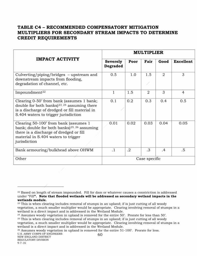
U.S. ARMY CORPS OF ENGINEERS NEW ENGLAND DISTRICT REGULATORY DIVISION 9-7-16
60
TABLE C4 – RECOMMENDED COMPENSATORY MITIGATION MULTIPLIERS FOR SECONDARY STREAM IMPACTS TO DETERMINE CREDIT REQUIREMENTS
IMPACT ACTIVITY MULTIPLIER
Severely Degraded
Poor Fair Good Excellent
Culverting/piping/bridges – upstream and downstream impacts from flooding, degradation of channel, etc.
0.5 1.0 1.5 2 3
Impoundment22 1 1.5 2 3 4
Clearing 0-50’ from bank (assumes 1 bank; double for both banks)23, 24 assuming there is a discharge of dredged or fill material in S.404 waters to trigger jurisdiction
0.1 0.2 0.3 0.4 0.5
Clearing 50-100’ from bank (assumes 1 bank; double for both banks)25, 26 assuming there is a discharge of dredged or fill material in S.404 waters to trigger jurisdiction
0.01 0.02 0.03 0.04 0.05
Bank armouring/bulkhead above OHWM .1 .2 .3 .4 .5
Other Case specific
22 Based on length of stream impounded. Fill for dam or whatever causes a constriction is addressed under “Fill”. Note that flooded wetlands will be addressed as secondary wetland impacts in the wetlands module. 23 This is when clearing includes removal of stumps in an upland; if is just cutting of all woody vegetation, a much smaller multiplier would be appropriate. Clearing involving removal of stumps in a wetland is a direct impact and is addressed in the Wetland Module. 24 Assumes woody vegetation in upland is removed for the entire 50’. Prorate for less than 50’. 25 This is when clearing includes removal of stumps in an upland; if is just cutting of all woody vegetation, a much smaller multiplier would be appropriate. Clearing involving removal of stumps in a wetland is a direct impact and is addressed in the Wetland Module. 26 Assumes woody vegetation in upland is removed for the entire 51-100’. Prorate for less.

U.S. ARMY CORPS OF ENGINEERS NEW ENGLAND DISTRICT REGULATORY DIVISION 9-7-16
61
TABLE C5 – RECOMMENDED COMPENSATORY MITIGATION MULTIPLIERS FOR STREAM CREDIT GENERATION
Starting Stream Condition Form of Mitigation27 (all shown as credits/lf)
Severely Degraded
Poor Fair Good Excellent
Preservation - Additional credit may be granted if entire meander width, which is wider than 100’ from the stream, is protected. One Side Both Sides
No credit28
0.1 0.2
0.25 0.5
0.4 0.8
Preservation of 100’ unaltered29 (0.5) 1.0
Daylighting/Elimination of fully lined channel 0.5 0.5 0.75 N/A N/A Removal of dams (measure linear feet of streambed exposed when the impoundment is removed)
1 1.5 2 2.5 N/A
Modifications to restore stream connectivity with its floodplain
0.1 0.2 0.3 0.4 N/A
Reestablishment of ≥ 25’ riparian buffer of deep-rooted vegetation, typically trees and shrubs, along one bank (double for both banks)
0.1 0.1 0.15 0.25 N/A
Reestablishment of natural stream channel (formerly channelized/ditched in natural substrate)
0.5 1.0 N/A N/A N/A
Establishment of new stream channel for relocated stream
0.1 0.3 0.5 N/A N/A
Installation of fish ladder (length of stream made accessible to migratory species) 1st 3 miles > 3 -10 miles
0.01 0.005
0.01 0.005
0.01 0.005
0.01 0.005
N/A
Other e.g., coarse woody material, removal of riprap or other fill/debris, livestock exclusion, upgrade culvert to meet the New England District Best Management Practices for Stream Crossings, stormwater improvements/BMPs.
Case-specific
N/A
27 Mitigation types can be additive if more than one type of mitigation is being done to a length of stream. 28 (unless associated with enhancement to bring stream to fully functional conditions, in which case 0.25 for one side and 0.5 for both sides) 29 no forestry, agriculture, or other modifications) buffer:

U.S. ARMY CORPS OF ENGINEERS NEW ENGLAND DISTRICT REGULATORY DIVISION 9-7-16
62
TABLE C6 – RECOMMENDED COMPENSATORY MITIGATION MULTIPLIERS FOR DIRECT PERMANENT IMPACTS TO SUBMERGED AQUATIC VEGETATION Mitigation Impacts
Restoration (re-establishment)
Creation (establishment)
Rehabilitation Preservation (protection/ management)
Vegetation re-planting
5 project specific30 project specific31 N/A
Conservation mooring installation
>5 N/A >5 N/A
Water quality improvements to watershed
project specific N/A project specific project specific
30 Rare cases, e.g., removal of uplands, old fill, etc. 31 E.g., remove pollutant source such as an outfall, remove moorings.

U.S. ARMY CORPS OF ENGINEERS NEW ENGLAND DISTRICT REGULATORY DIVISION 9-7-16
63
TABLE C7 – RECOMMENDED COMPENSATORY MITIGATION MULTIPLIERS FOR DIRECT PERMANENT IMPACTS TO OPEN WATER AND MUD FLATS Mitigation
Impacts
Restoration (re-establishment)
Creation (establishment)
Rehabilitation Preservation (protection/ management)
Open Water 1 1 project specific32 20
Mudflat 3 3 project specific 20
32 Might include planting submerged and/or floating aquatics and/or removal of invasive species.

U.S. ARMY CORPS OF ENGINEERS NEW ENGLAND DISTRICT REGULATORY DIVISION 9-7-16
64
APPENDIX D - MONITORING AND ASSESSMENT
MONITORING
Monitoring Report Format
Monitoring reports should generally follow a 10-page maximum report format per site, with a self-certification form transmittal33. Submission of electronic formats (e.g., pdf) is strongly encouraged. The information required should be framed within the following format.
1) Project Overview34 (1 page)
Highlighted summary of problems which need immediate attention (e.g., problem with hydrology, severe invasive species problem, serious erosion, major losses from herbivory, etc.). This should be at the beginning of the report and highlighted in the self-certification form and the project overview (Appendix D).
2) Requirements (1 page)
List all mitigation-related requirements as specified in the approved mitigation plan and special conditions of the permit including: the monitoring and performance standards, required financial assurances, required preservation, etc., and note whether required documents have been provided and evaluate whether the compensatory mitigation project site is effectively achieving the approved performance standards or trending toward meeting them.
3) Summary Data (maximum of 4 pages)
Summary data must be provided to substantiate the progress and/or potential challenges associated with the compensatory mitigation project. Photo documentation should be provided to support the findings and recommendations, and placed in the Appendix.
4) Maps/Plans (maximum of 3 pages)
Maps must be provided to show the location of the compensatory mitigation site relative to other landscape features, habitat types, locations of photographic reference points, transects, sampling data points, and/or other features pertinent to the mitigation plan. In addition, the submitted maps/plans must clearly delineate the mitigation site boundaries to assist in
33 see Appendix D 34 see Appendix D

U.S. ARMY CORPS OF ENGINEERS NEW ENGLAND DISTRICT REGULATORY DIVISION 9-7-16
65
proper locations for subsequent site visits. Each map or diagram must fit on a standard 8 ½ x 11” piece of paper and include a legend, bar scale, and the location of any photos submitted for review. Plans should be at the same orientation and scale as those found in the original mitigation plan attached to the permit.
5) Conclusions (1 page)
A general statement must be included describing the conditions of the compensatory mitigation project. If performance standards are not being met, a brief discussion of the difficulties and potential remedial actions proposed by the permittee, including a timetable, must be provided.
6) Monitoring Report Appendices
Appendix A -- An as-built plan showing topography to 1-foot contours, any inlet/outlet structures and the location and extent of the designed plant community types (e.g., shrub swamp). Within each community type the plan shall show the species planted—but it is not necessary to illustrate the precise location of each individual plant. There should also be a soil profile description and the actual measured organic content of the topsoil. This should be included in the first monitoring report unless there is grading or soil modifications or additional plantings of different species in subsequent years.
Appendix B – A vegetative species list of each plant community type. The species list should, at a minimum, include those that cover at least 5% of their vegetative layer. The list should include both planted and volunteer species.
Appendix C -- Representative photos of each mitigation site taken from the same positions, angles, and magnification for each monitoring event. Photos should be dated and clearly labelled with the direction from which the photo was taken. The photo sites must also be identified on the appropriate maps.
Monitoring Report Requirements
• Address achievement of performance standards and/or measures to attain the standards.
• Describe the monitoring inspections, and provide their dates, that occurred since the last report.
• Soils data, commensurate with the requirements of the soils portion of the most recent Corps of Engineers Wetland Delineation Manual and Regional Supplement to the Corps of Engineers Wetland Delineation Manual:

U.S. ARMY CORPS OF ENGINEERS NEW ENGLAND DISTRICT REGULATORY DIVISION 9-7-16
66
Northcentral and Northeast should be collected after construction and every alternate year throughout the monitoring period. If IRIS tubes (Rabenhorst 2008), monitoring wells, or gauges were installed as part of the project, this hydrology data should be submitted annually.
• Concisely describe remedial actions done during the monitoring year to meet the performance standards – actions such as removing debris, replanting, controlling invasive plant species (with biological, herbicidal, or mechanical methods), regrading the site, applying additional topsoil or soil amendments, adjusting site hydrology, etc. Also describe any other remedial actions done at each site.
• Report the status of all erosion control measures on the compensation site(s). Are they in place and functioning? If temporary measures are no longer needed, have they been removed?
• Give visual estimates of (1) percent vegetative cover for each mitigation site and (2) percent cover of the invasive species required (by performance standard) to be controlled in each mitigation site.
• What fish and wildlife use the site(s) and what do they use it for (nesting, feeding, shelter, etc.)?
• By species planted, describe the general health and vigor of the surviving plants, the prognosis for their future survival, and a diagnosis of the cause(s) of morbidity or mortality.
ASSESSMENT Assessment Format
The post-construction assessment shall include the four assessment appendices listed below and shall:
• Summarize the original or modified mitigation goals (performance standards) and discuss the level of attainment of these goals at each mitigation site.
• Describe significant problems and solutions during construction and maintenance (monitoring) of the mitigation site(s).
• Identify agency procedures or policies that encumbered implementation of the mitigation plan. Specifically note procedures or policies that contributed to less effectiveness than anticipated in the mitigation plan.
• Recommend measures to improve the efficiency, reduce the cost, or improve the effectiveness of similar projects in the future.

U.S. ARMY CORPS OF ENGINEERS NEW ENGLAND DISTRICT REGULATORY DIVISION 9-7-16
67
Assessment Appendices
Appendix A -- Summary of the results of a functions and values assessment of the mitigation site(s), using the same methodology used to determine the functions and values of the impacted wetlands.
Appendix B -- Calculation of the area by type of aquatic resources (e.g., wetlands, vernal pools, streams, bogs, tidal, etc.) in each mitigation site. Wetlands should be identified and delineated using the Corps Wetland Delineation Manual and approved regional supplements. Supporting documents shall include (1) a scaled drawing showing the aquatic resource boundaries and representative data plots and (2) datasheets for the corresponding data plots.
Appendix C -- Comparison of the area and extent of delineated created/restored/ rehabilitated aquatic resources (from Appendix B) with the area and extent of created/restored/rehabilitated aquatic resources proposed in the mitigation plan. This comparison shall be made on a scaled drawing or as an overlay on the as-built plan. This plan shall also show any major vegetation community types (e.g., delineate boundaries between forested, scrub-shrub, and emergent) and determine amounts of each.
Appendix D -- Photos of each mitigation site taken from the same positions, angles, and magnifications as the monitoring photos.

U.S. ARMY CORPS OF ENGINEERS NEW ENGLAND DISTRICT REGULATORY DIVISION 9-7-16
68
MITIGATION MONITORING REPORT TRANSMITTAL AND SELF-CERTIFICATION
DEPARTMENT OF THE ARMY PERMIT NUMBER: PROJECT TITLE: PERMITTEE: MAILING ADDRESS: TELEPHONE: AUTHORIZED AGENT: MAILING ADDRESS: TELEPHONE: ATTACHED MITIGATION REPORT TITLE: PREPARERS: DATE: CERTIFICATION OF COMPLIANCE: I certify that the attached report is accurate and discloses that the mitigation required by the Department of the Army Permit [is] [is not] in full compliance with the terms and conditions of that permit. CORRECTIVE ACTION: A need for corrective action [is] [is not] identified in the attached report. CONSULTATION: I [do] [do not] request consultation with the Corps of Engineers to discuss a corrective strategy or permit modification. CERTIFIED:__________________________________________________________________ (Signature of permittee) Date

U.S. ARMY CORPS OF ENGINEERS NEW ENGLAND DISTRICT REGULATORY DIVISION 9-7-16
69
MITIGATION MONITORING REPORT PROJECT OVERVIEW FORM
Corps Permit No.: Mitigation Site Name(s): Monitoring Report : of Name and Contact Information for Permittee and Agent: Name of Party Responsible for Conducting the Monitoring: Date(s) of Inspection(s): Project Summary: [include purpose of approved project, acreage and type of aquatic resources impacted, and mitigation acreage and type of aquatic resources authorized to compensate for the aquatic impacts] Location of and Directions to Mitigation Site(s): Start and Completion Dates for Mitigation: Performance Standards are/are not being met: [describe how] Dates of Corrective or Maintenance Activities Conducted Since Last Report: Recommendations for Additional Remedial Actions:

U.S. ARMY CORPS OF ENGINEERS NEW ENGLAND DISTRICT REGULATORY DIVISION 9-7-16
70
APPENDIX E - WETLANDS MODULE Table of Contents I. Overview II. Documenting Impacted Wetlands III. Mitigation Type and Goals IV. Mitigation Site Selection V. Special Considerations VI. Monitoring Needs VII. Wetlands Module Checklist VIII. Wetlands Module Instructions OVERVIEW
The majority of impacts to aquatic resources for which we require compensatory mitigation involves wetlands; therefore, they are the most common type of compensatory mitigation.
DOCUMENTING IMPACTED WETLANDS
At a minimum, the areal cover of wetlands that are proposed to be impacted (primary, secondary, and temporary impacts) should be documented. The various types of wetlands (e.g., Cowardin classification, hydrogeomorphic classification) should also be documented and quantified. Where functional assessment of the wetlands is necessary to properly evaluate impacts and devise adequate mitigation, the Corps shall be consulted on an appropriate method to use.
MITIGATION TYPE AND GOALS
In order to more closely replace impacted functions, in-kind mitigation is generally preferred to out-of-kind mitigation for impacted wetlands that are not heavily degraded, provided this is appropriate based on watershed scale considerations. Out-of-kind mitigation may be preferred for heavily degraded systems or where it would be more beneficial to the overall watershed or other appropriate project-specific boundary.
MITIGATION SITE SELECTION
Mitigation site selection should follow the requirements noted in the Mitigation Rule and cited in section 2.e. of this guidance document.

U.S. ARMY CORPS OF ENGINEERS NEW ENGLAND DISTRICT REGULATORY DIVISION 9-7-16
71
SPECIAL CONSIDERATIONS
Microtopography
Note that natural wetland systems, particularly those with trees and/or shrubs, typically have an intricate pattern of topographic relief. Created or restored areas should have variability (elevational and size) similar to the impacted resource or other suitable reference area.
Soil
Manmade topsoil shall consist of a mixture of equal volumes of organic and mineral materials. Well-decomposed clean leaf compost is the preferred soil amendment to achieve these standards. Note that “clean” refers both to a negligible amount of physical contaminants such as plastic and to the lack of chemical contaminants that might pose a hazard to plants or animals. If other soil amendments are more readily available than clean leaf compost, they can be used to meet the requirement for the appropriate percent organic carbon content. Note, however, that compost or other organic matter should be clean and free of weed seeds, specifically the seeds of the species listed in Appendix K. Commercial peat is not recommended for soil amendments as its harvesting methods are generally destructive to wetlands. Caution should be used when using non-commercial peat salvaged from project impact sites as the chemical composition of that material may not be adequately buffered against phytotoxic levels of pH. This has resulted in the failure of some mitigation sites.
It is important to keep in mind the difference between organic matter and organic carbon both for meeting regulatory guidelines and when classifying the surface horizons in soils as histic (organic soils), mucky modified, or mineral. The organic carbon content of most upland topsoil is between 1 and 6 percent of dry weight. Soils with more than 20 to 30 percent organic matter (12 to 17 percent organic carbon content) are known as organic soils or Histosols if in a layer of adequate thickness. The Field Indicators for Identifying Hydric Soils in New England [New England Hydric Soils Technical Committee, 2016, 4th ed.] glossary defines the criteria for these classifications based on their organic carbon contents. A minimum organic carbon content of 4-12% (7 to 21 percent organic matter) on a dry weight basis for soils should be used in wetland replication areas. The rule of thumb for conversion is to divide percent organic matter by 1.72 to get percent organic carbon content and multiply percent organic carbon by 1.72 to get percent organic matter content35:
%Om/1.72 = %Oc and %Oc x 1.72 = %Om
Scrub-shrub and forested wetland soils should have about 12% organic carbon; soils in emergent wetlands in permanently or semi-permanently inundated areas may only need 4-6%. Under certain circumstances, increased organic matter can lead to 35 Excerpted from Allen, Art, “Organic Matters”, AMWS Newsletter, December 2001.

U.S. ARMY CORPS OF ENGINEERS NEW ENGLAND DISTRICT REGULATORY DIVISION 9-7-16
72
acidification of the soil, which damages the soil microbial community and the vegetation. Care should be taken to properly evaluate the soil and hydrology proposed for a site to prevent this from occurring.
Note that the term “loam” that is frequently used for the material spread on a mitigation site after subsoil grading is a landscaping term. In soil science, the term refers to a specific texture of soil comprised of specific amounts of sand, silt, and clay particles. The landscaping term is not a scientific term and should be avoided.
When topsoil must be stockpiled on site, the plan should include plans for maintaining moisture in the soil. The following measures are suggested for the contractor doing the work:
• Soil should not be stockpiled in wetlands or waters • Seek approval for location of stockpiled materials (from owner/engineer); • Avoid stockpiling compost organics in piles over 4 feet in height; • Protect stockpiles from surface water flow and contain them with hay bales
and/or silt fence; • Cover stockpiles with a material that prevents erosion (tarps, erosion control
mat, straw and temporary seed, depending on size and duration of storage) • Inspect and repair protection measures listed above regularly (weekly), as well as
prior to (to the extent possible) and after storm events. • Maintain moisture in the soils during droughty periods.
Soil Compaction - Soil compaction by heavy machinery may adversely affect plantings and/or may result in perching of water. Therefore, efforts should be made to minimize soil compaction area during grading of the mitigation site. If use of heavy machinery cannot be avoided, compaction must be addressed by disking or some other treatment to loosen the soil surface. Finer grained soils are more susceptible to compaction than more coarsely grained soils, so clayey soils should not be worked at all except in extremely dry condition. Similar consideration should be given while spreading the topsoil.
Coarse Woody Material
Coarse woody material includes such materials as logs (ideally, a mix of hardwoods for longevity and softwoods), stumps, smaller branches, and standing snags but not woodchips or mulch made from wood, which breaks down much more quickly. Placement of this coarse woody material is generally inappropriate in tidal or frequently flooded environments unless it is appropriately anchored, and may not be appropriate for some herbaceous systems. As much as possible, these materials will be in various stages of decomposition and salvaged from natural areas cleared for the other elements of the project. Where floodwaters are a factor, it may be practical to anchor or partially bury snags and other larger components of woody material. In fact, large woody material in stream channels performs many stream functions including retention of sediment and nutrients, creation and maintenance of pools, and complex

U.S. ARMY CORPS OF ENGINEERS NEW ENGLAND DISTRICT REGULATORY DIVISION 9-7-16
73
habitats for aquatic biota. Beaver, by cutting and redistributing large woody material, create ponds and wetlands that add diverse aquatic resource habitats.
When mitigation requires a component of forest or scrub-shrub habitat, the design should include plans for a continuum of coarse woody material, including snags (standing dead trees). This continuum should include a full range of sizes, including small twigs and brush, not merely larger logs, stumps, and snags. Woody material also plays an important role in vernal pool habitat by providing egg mass attachment sites in the pool basin and terrestrial refuges in the adjacent terrestrial habitat. NOTE: if not properly screened by a wetland scientist, coastal habitat scientist, stream scientist etc., such material can be a source of invasive species.
When a tree dies, it may continue to provide habitat for another century or longer. The speed of the recycling processes depends on many factors, but the main point is that coarse woody materials are relatively durable and remain as important ecological features both below- and above-ground for a long time. Long after the last needles or leaves fall to the forest floor, a tree decomposes slowly over time.
In the first years, if a tree remains upright, the greatest volume of its litter may consist of bark, twigs, and small branches. Later, as insects and fungus weaken the aerial framework, larger limbs and sections of the trunk tumble to the ground where decay occurs under quite different conditions. On the forest floor, well-decomposed logs may sustain greater faunal richness. In an ideal situation, there is an uninterrupted supply of woody litter in various sizes and stages of decay providing a diverse range of habitats. Decomposition is one of the natural processes in a healthy forest. If one link of the chain is lacking, the process falters. Wetland builders should factor coarse woody material into most habitat mitigation strategies.
Frequently the inclusion of scattered various sized boulders, as well as woody material, is an appropriate method of increasing structure and habitat in a site.
Tidal Wetland Establishment
The guidance in this section should be applied with the understanding that sea levels are not static and are currently in a rising trend which is expected to continue into the foreseeable future. The Corps civil works programs operate under the policy that “potential relative sea-level change must be considered in every USACE coastal activity as far inland as the extent of estimated tidal influence.”36 Tidal wetland establishment planning must take into account these ongoing changes. There are a variety of sources for information on current and projected sea levels. The Corps has its “USACE Sea Level Change Curve Calculator (2015.46)” which is available on-line.
Planting zones should be based on species requirements and a tidal datum. Each species must be planted at the appropriate elevation for that species and at the proper 36 EC 1100-2-8162. 31 December 2013

U.S. ARMY CORPS OF ENGINEERS NEW ENGLAND DISTRICT REGULATORY DIVISION 9-7-16
74
depth. Following grading, a survey shall be conducted to determine if supplemental backfill materials need to be placed to achieve required elevations for planting. If necessary, supplemental backfill shall be applied and then allowed to settle for a minimum of six tidal cycles prior to planting.
The potential for establishment of Phragmites australis and Lepidium latifolium is an important consideration in the design of tidal wetlands. Selected backfill material should be free of seed and vegetative propagules of Phragmites. For freshwater tidal wetlands, Lythrum salicaria may also be a species of concern.
The elevation of low marsh should be identified and considered in the design and should be provided in the plan. Low marsh plants should be planted between mean tide level and mean high water. High marsh plants should be planted between mean high water and spring high water. Salt hardened plants are most likely to survive. Plant storage on site should be kept short (less than 2 weeks). Planting densely (i.e., on 12 inch centers) will encourage the site to provide habitat and some water quality functions more quickly. A nitrogen-rich slow-release fertilizer may be added to each planting hole prior to closing. Salt marsh cordgrass (Spartina alterniflora) is shade intolerant, so it should not be planted in shady areas or, if a mitigation plan involves planting a riparian buffer, trees should not be planted within 20 feet of a salt marsh mitigation area. Additionally, salt marsh cordgrass is recommended to be planted on 18-inch centers, 2 culms per hole. Also, in areas with geese, a goose exclusion system is very important during the plant establishment period.
MONITORING NEEDS
Minimum monitoring for emergent and scrub-shrub systems will typically be for 5 years with monitoring events every year. Minimum monitoring for forested systems will typically be for 10 years with monitoring events on years 1, 2, 3, 5, 7, and 10.
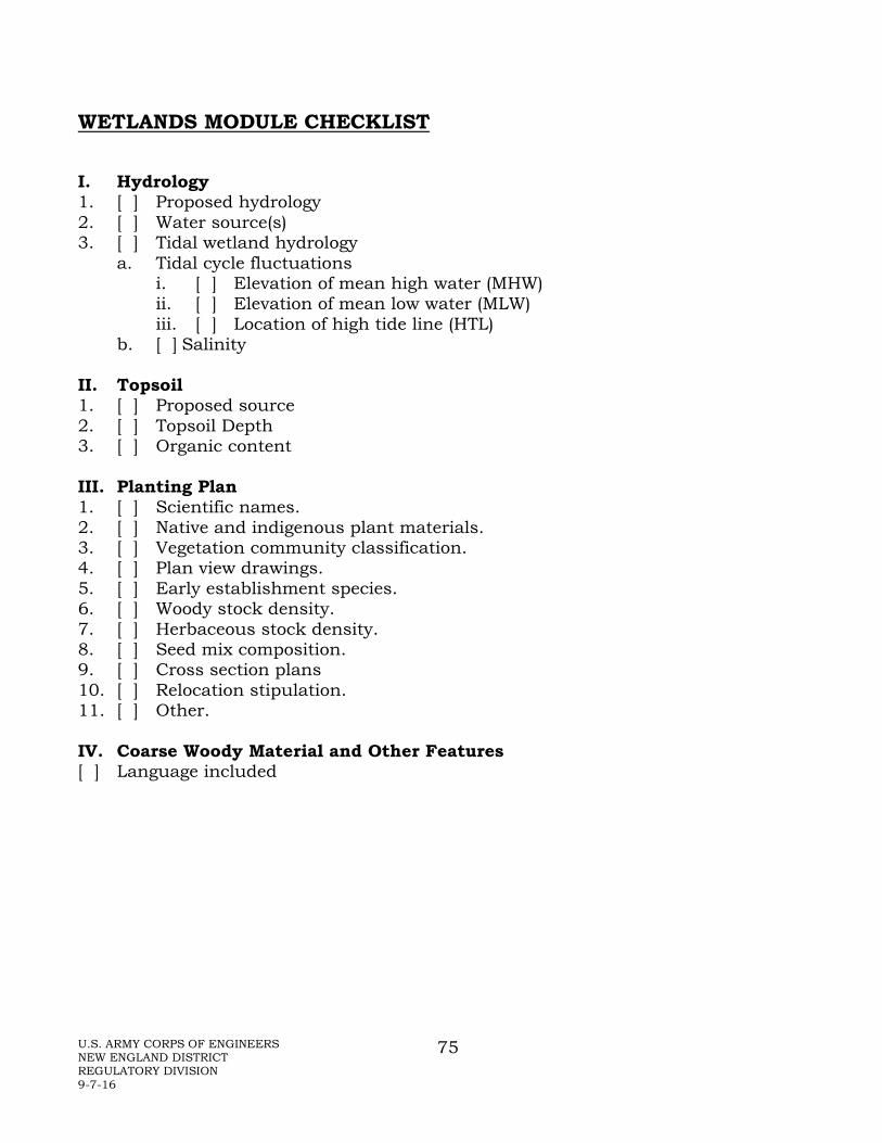
U.S. ARMY CORPS OF ENGINEERS NEW ENGLAND DISTRICT REGULATORY DIVISION 9-7-16
75
WETLANDS MODULE CHECKLIST
I. Hydrology 1. [ ] Proposed hydrology 2. [ ] Water source(s) 3. [ ] Tidal wetland hydrology
a. Tidal cycle fluctuations i. [ ] Elevation of mean high water (MHW) ii. [ ] Elevation of mean low water (MLW) iii. [ ] Location of high tide line (HTL)
b. [ ] Salinity
II. Topsoil 1. [ ] Proposed source 2. [ ] Topsoil Depth 3. [ ] Organic content III. Planting Plan 1. [ ] Scientific names. 2. [ ] Native and indigenous plant materials. 3. [ ] Vegetation community classification. 4. [ ] Plan view drawings. 5. [ ] Early establishment species. 6. [ ] Woody stock density. 7. [ ] Herbaceous stock density. 8. [ ] Seed mix composition. 9. [ ] Cross section plans 10. [ ] Relocation stipulation. 11. [ ] Other. IV. Coarse Woody Material and Other Features [ ] Language included

U.S. ARMY CORPS OF ENGINEERS NEW ENGLAND DISTRICT REGULATORY DIVISION 9-7-16
76
WETLANDS MODULE CHECKLIST DIRECTIONS
I. HYDROLOGY
1. Evidence of adequate hydrology to support the desired wetland. The expected seasonal depth, duration, and timing of both inundation and saturation should be described for each of the proposed habitat zones in the mitigation area (particularly related to root zone of the proposed plantings). If shallow monitoring wells are used to develop this rationale, the observations should be correlated to local soil morphologies, rooting depths, water marks or other local evidence of flooding, ponding, or saturation, and reflect rainfall conditions during monitoring.
2. Plan indicates if the water source is groundwater, surface runoff, precipitation, lake and/or stream overflow, tidal, and/or springs and seeps. Provide substantiation (e.g., well data, adjacent wetland conditions, stream gauge data, precipitation data).
3.a. Evidence of adequate tidal cycle to support the desired wetland. For tidal wetlands, the expected tidal cycle fluctuations in depth, duration, and timing of both inundation and saturation should be described for each of the proposed habitat zones in the mitigation area (particularly related to root zone of the proposed plantings). Note elevations of mean high water (MHW), mean low water (MLW), and the high tide line, as well as expected storm tide.
3.b. Salinity range is important for plant and animal species usage and survival.
II. TOPSOIL AND SUBSTRATE
1. Proposed source of topsoil or substrate supplements. Topsoil and other substrate materials for mitigation sites can be a source of invasive species seeds. Provide information on the source and the likelihood that such seeds are in it.
2. Twelve or more inches of natural or manmade topsoil should be used in most wetland mitigation areas. Exceptions might be permanently or semi-permanently inundated or saturated areas and turtle nesting areas. Rationale for less than 12 inches should be provided.
3. Appropriate organic content of topsoil and substrate supplements (if necessary). Natural topsoil proposed to be used for the creation/restoration/ rehabilitation of wetlands consists of at least 4-12% organic carbon content (by weight) (or 9-21% organic matter content), with the percentage specified. Manmade topsoil used for the creation/restoration/rehabilitation of wetlands consists of a mixture of equal volumes of organic and mineral materials. This may be accomplished by adding a specific depth of organic material and disking it in to twice that depth. The actual measured organic content of the topsoil used should be provided in the as-built plan submitted with the first monitoring report. Manufactured soil may also have to be tested for contaminants. NOTE: For tidal wetlands, there is no recommended standard for

U.S. ARMY CORPS OF ENGINEERS NEW ENGLAND DISTRICT REGULATORY DIVISION 9-7-16
77
substrate organic content, but it is recommended to match that of a nearby reference tidal wetland.
III. PLANTING PLAN
1. Plans must use scientific names. Since there are no standardized common names for plants, the use of scientific names ensures that all involved have the correct understanding of the species of plants proposed to be planted or seeded.
2. Plant materials are native and indigenous to the area of the site(s); invasive species, nonnative species, and/or cultivars are not proposed for planting or seeding. During the first few years while the designed wetland vegetative zones become established, they are susceptible to colonization and subsequent domination by invasive species. A number of plants are known to be especially troublesome in this regard. The following stipulation shall be included in the mitigation plan, either in the plan view or in the narrative portion of the plan:
To reduce the immediate threat and minimize the long-term potential of degradation, the species included on the “Invasive and Other Unacceptable Plant Species” list in Appendix K of the New England District Compensatory Mitigation Guidance shall not be included as planting stock in the overall project. Only plant materials native and indigenous to the region shall be used (with the exception of [specify]). Species not specified in the mitigation plan shall not be used without prior written approval from the Corps.
3. All vegetation types or zones are classified in accordance with Cowardin, et al. (1979) or other similar classification system. The Cowardin classification system is typically used to identify the plant communities proposed. If another system is used, an explanation of terms may be needed.
4. A plan view drawing should show where the various species are proposed to be planted. The drawing should show the proposed locations of planted stock and vegetative community zones in relation to expected hydrology. Since showing each individual plant is neither practical nor realistic, this may be illustrated with areas of uniform species composition and the number of plants or rate of seeding within the polygon. The scale should be in the range of 1”=20’ to 1”=100’, depending on the size of the site.
5. More than 50% of the plantings in each zone are species that will become structural determinants for the community type designated for that zone. Although the prevailing hydrology will ultimately influence the type of wetland that will develop, plantings “jump start” the project. When determining species to plant, considerations should include the tendency of some species to volunteer promptly whereas others may take years to move into a site. Determine whether it is preferable to include rapidly establishing species to help prevent invasive species problems or to emphasize planting species unlikely to “volunteer” during the monitoring period.

U.S. ARMY CORPS OF ENGINEERS NEW ENGLAND DISTRICT REGULATORY DIVISION 9-7-16
78
6. Woody stock should be proposed to be planted in densities not less than 600 trees and shrubs per acre, including at least 400 trees per acre in forested cover types.
7. Where uniform coverage is anticipated, herbaceous stock should be proposed to be planted in densities not less than the equivalent of 3 feet on center for species which spread with underground rhizomes; 2 feet on center for species which form clumps; and salt marsh cordgrass is recommended to be planted on 18-inch centers, 2 culms per hole.
8. The list of species proposed in seed mixes should not include any species in the list of invasives in Appendix K. Similarly, non-native genotypes and cultivars should not be used.
9. Cross-sectional drawings should include identification of vegetative community zones (e.g., forested, shrub swamp, high marsh, low marsh, etc.). This can be combined with the plans required for grading if they are not too complex.
10. The following stipulation shall be included in the mitigation plan, either in the drawings or in the narrative portion of the plan:
During planting, a qualified wetland professional may relocate up to 50 percent of the plants in each community type if as-built site conditions would pose an unreasonable threat to the survival of plantings installed according to the mitigation plan. The plantings shall be relocated to locations with suitable hydrology and soils and where appropriate structural context with other plantings can be maintained.
11. Specific staff recommendations related to planting.
IV. COARSE WOODY MATERIAL AND OTHER FEATURES
Appropriate amounts and range of decomposition of coarse woody material are proposed. The following language shall be included in the mitigation plan, either in the drawings or in the narrative portion of the plan:
A supply of dead and dying woody material shall cover at least 4% of the ground throughout the mitigation sites after the completion of construction of the mitigation sites. These materials should not include species shown on the list of invasive species (Appendix K) in the New England District Compensatory Mitigation Guidance.
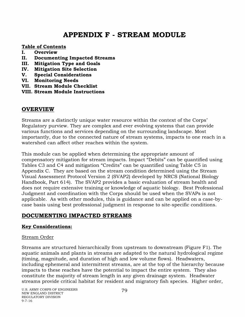
U.S. ARMY CORPS OF ENGINEERS NEW ENGLAND DISTRICT REGULATORY DIVISION 9-7-16
79
APPENDIX F - STREAM MODULE Table of Contents I. Overview II. Documenting Impacted Streams III. Mitigation Type and Goals IV. Mitigation Site Selection V. Special Considerations VI. Monitoring Needs VII. Stream Module Checklist VIII. Stream Module Instructions
OVERVIEW
Streams are a distinctly unique water resource within the context of the Corps’ Regulatory purview. They are complex and ever evolving systems that can provide various functions and services depending on the surrounding landscape. Most importantly, due to the connected nature of stream systems, impacts to one reach in a watershed can affect other reaches within the system. This module can be applied when determining the appropriate amount of compensatory mitigation for stream impacts. Impact “Debits” can be quantified using Tables C3 and C4 and mitigation “Credits” can be quantified using Table C5 in Appendix C. They are based on the stream condition determined using the Stream Visual Assessment Protocol Version 2 (SVAP2) developed by NRCS (National Biology Handbook, Part 614). The SVAP2 provides a basic evaluation of stream health and does not require extensive training or knowledge of aquatic biology. Best Professional Judgment and coordination with the Corps should be used when the SVAPs is not applicable. As with other modules, this is guidance and can be applied on a case-by-case basis using best professional judgment in response to site-specific conditions.
DOCUMENTING IMPACTED STREAMS
Key Considerations:
Stream Order
Streams are structured hierarchically from upstream to downstream (Figure F1). The aquatic animals and plants in streams are adapted to the natural hydrological regime (timing, magnitude, and duration of high and low volume flows). Headwaters, including ephemeral and intermittent streams, are at the top of the hierarchy because impacts to these reaches have the potential to impact the entire system. They also constitute the majority of stream length in any given drainage system. Headwater streams provide critical habitat for resident and migratory fish species. Higher order,

U.S. ARMY CORPS OF ENGINEERS NEW ENGLAND DISTRICT REGULATORY DIVISION 9-7-16
80
perennial streams (fourth order and above) are known for higher productivity and valuable fish habitat. Perennial streams provide aquatic organism habitat year round as opposed to ephemeral headwater streams that typically support few aquatic organisms. Maintaining unobstructed access to these habitats is essential to preserving the natural biodiversity of the system.
Figure F1. Stream Order (from Strahler)
Stream Type
All streams respond differently to disturbances. For example, stream reaches with steep slopes, containing bedrock or large boulders within confined channels are typically less prone to disturbance from changes in fine sediment supply and hydrology compared to reaches of flatter slope with finer textured substrates within wider channel valleys. Stream reaches that are plane-bed, riffle-pool, braided, or dune and ripple are typically better at retaining nutrients and sediment. Differences in physical composition also result in differing biogeochemistry, nutrient recycling, habitat, and food web functions. Consequently, it is important to document the physical characteristics of the streams since, when mitigation is required, it will help determine if similar functions are restored or enhanced.

U.S. ARMY CORPS OF ENGINEERS NEW ENGLAND DISTRICT REGULATORY DIVISION 9-7-16
81
MITIGATION TYPE AND GOALS
Defining Goals, Objectives, and Performance Standards:
It is important for stream mitigation projects to have clearly defined goals. Specific performance standards will be integral to assessing the trajectory of the mitigation site. Goals will typically be targeted towards achieving some level of physical, chemical, and/or biological improvement within the stream system. Below is a partial list of stream mitigation projects by type and the functions they may restore or enhance.
Removal of Dams or culverts effectively functioning as dams • Restore native ecosystem productivity and biodiversity • Increase sediment, nutrient, and wood transport • Restore natural hydrologic regime • Improve water quality and thermal regime • Improve riparian functions • Restore migration and movement of aquatic biota (fish, invertebrates, etc.) • Restore availability of upstream aquatic habitats
Existing culvert upgrades (to meet the New England District Best Management Practices for Stream Crossings) or removal
• Increase/restore native ecosystem productivity and biodiversity • Increase/restore sediment, nutrient, and wood transport • Restore natural hydrologic regime • Improve migration and movement of aquatic biota • Increase/restore availability of upstream aquatic habitats
Restoration of riparian and floodplain vegetation • Increase native ecosystem productivity and biodiversity • Increase habitat complexity of stream ecosystem • Increase sediment and nutrient retention in riparian areas and floodplains • Improve thermal regimes, e.g., shading by riparian vegetation • Improve water quality
Re-establish connections to floodplains and side channels • Increase native ecosystem productivity and biodiversity • Increase habitat complexity of stream ecosystem • Increase sediment and nutrient retention in riparian areas and floodplain • Improve access to refuge and reproductive habitat for organisms • Improve thermal regimes, e.g., shading by riparian vegetation • Improve water quality • Reduce flashiness • Restore natural hydrologic regime
Remove riprap and concrete banks and channels and revegetate

U.S. ARMY CORPS OF ENGINEERS NEW ENGLAND DISTRICT REGULATORY DIVISION 9-7-16
82
• Increase native ecosystem productivity and biodiversity • Increase availability of sediment, woody material, nutrients for aquatic habitats • Improve hydrological regimes • Increase habitat complexity and diversity for aquatic life • Improve sediment and nutrient transport and retention/recycling dynamics • Improve thermal regimes and water quality • Potentially increase base flow • Restore dynamic channel boundary; allow natural avulsion (migration of
channel) within floodplain
Improve stormwater storage and processing • Increase native ecosystem productivity and biodiversity • Restore natural hydrologic regime • Reduce flashiness • Improve water quality and thermal regimes • Improve habitat complexity and diversity for aquatic life • Reduce sources of pollutants (including excess fine sediment)
Enhance or restore riparian buffer • Increase native ecosystem productivity and biodiversity • Improve habitat complexity and diversity for aquatic life • Improve thermal regimes and water quality • Increase retention of woody material, sediment and nutrients • Improve sediment and nutrient recycling
Install coarse woody material in stream/along banks • Increase native ecosystem productivity and biodiversity • Improve habitat complexity and diversity for aquatic life • Improve thermal regimes and water quality • Increase retention of wood, sediment and nutrients • Improve sediment and nutrient recycling
Use Low Impact Development (LID) technology (pervious surfaces, rain gardens, filter strips, etc.)
• Increase native ecosystem productivity and biodiversity • Restore natural hydrologic regime • Improve water quality and thermal regimes • Improve habitat complexity and diversity for aquatic life • Reduce flashiness
Remove pavement and other impervious surfaces
• Increase native ecosystem productivity and biodiversity • Improve hydrologic regime

U.S. ARMY CORPS OF ENGINEERS NEW ENGLAND DISTRICT REGULATORY DIVISION 9-7-16
83
• Improve water quality and thermal regimes • Improve habitat complexity and diversity for aquatic life
Remove pavement and other impervious surfaces • Preserve native ecosystem productivity and biodiversity • Preserve availability of sediment, wood, nutrients for aquatic habitats • Preserve hydrological regimes • Preserve habitat complexity and diversity for aquatic life • Preserve sediment and nutrient transport and retention/recycling dynamics • Preserve thermal regimes and water quality
Determining Stream Debits/Credits
Unlike wetlands, streams require three matrices: one to calculate the credits required to compensate for various stream impacts (Table C3), one for secondary impacts (Table C4), and another to address the credits generated by various preservation, enhancement, and/or restoration projects (Table C5). Five ratio multipliers have been provided for each activity in order to compensate for varying stream conditions as determined using the Stream Visual Assessment Protocol Version 2 (SVAP2). The ratio multipliers are then multiplied by the length of stream (or stream bank) impacted by the project, to calculate the necessary credits required to compensate for the stream impacts. Best professional judgment should be used to complete the SVAP2 Worksheet and determine whether the stream in the area of the impact or mitigation project is currently Severely Degraded, Poor, Fair, Good, or Excellent. Multipliers should then be applied accordingly. It should be noted that these tables assume that impacts are permanent. In general, for impacts not expected to last more than one year, mitigation is not recommended. For impacts expected to last more than one year but no more than two years, multiply the credits needed to provide appropriate compensation by 0.25. Calculating Mitigation Credits Needed (“Debits”):
1. Complete the Stream Visual Assessment Protocol Worksheet. 2. Determine whether the stream to be impacted is Severely Degraded, Poor, Fair,
Good, or Excellent. 3. For each Impact Activity associated with the project, determine the linear feet of
direct impacts to the stream. 4. Using the appropriate multiplier, calculate the mitigation credits needed to
compensate for each Impact Activity. 5. Calculate the total mitigation credits needed to compensate for the project
impacts by adding all of the credits calculated in Step 4. Calculating Mitigation Credits Generated:
U.S. ARMY CORPS OF ENGINEERS NEW ENGLAND DISTRICT REGULATORY DIVISION 9-7-16
84
1. Complete the Stream Visual Assessment Protocol Worksheet. 2. Determine whether the stream to be modified is Severely Degraded, Poor, Fair,
Good, or Excellent. 3. For each Form of Mitigation, determine the linear feet of proposed mitigation. 4. Use the appropriate multiplier to calculate the mitigation credits generated from
each Form of Mitigation proposed. 5. Calculate the total mitigation credits the proposed mitigation would generate by
adding all of the credits calculated in Step 4.
MITIGATION SITE SELECTION
There are many variables influencing the physical, chemical and biological composition of stream systems. All of these variables should be considered to the extent practicable when planning a mitigation project and include, but are not limited to, geography, bed material, fluvial geomorphology, and position within the surrounding landscape.
SPECIAL CONSIDERATIONS
Floodplains
Floodplains are important in modulating stream flow, supplying substrate for biogeochemical transformations (including denitrification), supplying and receiving coarse woody material, and providing habitat for diverse aquatic and terrestrial organisms. Overbank flow and channel migrations across the belt width create and maintain a diverse array of habitat types, including secondary channels, oxbow ponds, marshes, vernal pools, and forested wetlands.
Riparian Buffers
Vegetated riparian buffers may help regulate water temperatures, intercept pollutants and sediment, and provide detritus which is a vital component of aquatic food webs. Buffers also provide migration corridors and can provide critical habitat for many non-aquatic species associated with stream habitat.
Changes to riparian vegetation can have long-term impacts on coarse woody material recruitment. Replacement of riparian vegetation with riprap or other hard structures along stream banks can impact water temperature, water quality, wildlife and fish habitat, stream stability and overall functionality. Such alterations can encourage recruitment of invasive species.
In-Stream Structures: Natural
Coarse woody material and boulders are stream features that retain materials such as sediment, organic matter, and nutrients, especially in small and moderate sized streams. As detritus decomposes, it supplies dissolved organic carbon (DOC) used in denitrification and particulate organic carbon (POC) used by shredder organisms.

U.S. ARMY CORPS OF ENGINEERS NEW ENGLAND DISTRICT REGULATORY DIVISION 9-7-16
85
These natural in-stream structures create and maintain complex stream habitat features such as riffles, pools, and other resting and hiding habitat for aquatic biota. Channelization and/or removal of large, in-stream material can alter hydrologic flow characteristics as well as limit sediment and nutrient retention.
Many of the processes important in a natural high functioning system would be impaired by static structures so this should be taken into consideration in the stream mitigation design. Also, smaller diameter and length logs will be highly mobile in larger systems, and of less habitat value.
In-Stream Structures: Engineered
Vanes, J-hooks, weirs, and a variety of other structures have been installed to improve fish habitat, and direct flows away from banks and structures, etc.
Dam Removals
Potential impacts to wetlands associated with dam removals must be considered on a case-by-case basis. Factors to consider include the likelihood of establishment of new wetlands along the new stream channel, the loss of large expanses of wetland with little likelihood of any establishment of new wetlands, or the establishment of floodplain wetlands where there were few wetlands in and around the impoundment. These factors should be balanced with the restoration of stream function as described in the performance standards below.
Dam removals may also be considered as compensatory mitigation but must include an assessment of potential impacts as well as benefits.
MONITORING NEEDS
Monitoring for stream mitigation will generally be for a minimum of 10 years, with monitoring events typically occurring in years 1, 2, 3, 5, 7, and 10.

U.S. ARMY CORPS OF ENGINEERS NEW ENGLAND DISTRICT REGULATORY DIVISION 9-7-16
86
STREAM MODULE CHECKLIST
NOTE: If the SVAP2 is used, some of these items may be addressed on that protocol’s summary sheet.
I. Hydrology 1. [ ] Flow regime 2. [ ] Watershed size. 3. [ ] Location in watershed. 4. [ ] Water source(s). 5. [ ] Salinity, if applicable. II. Substrate 1. [ ] Substrate type. 2. [ ] Proposed source of material. 3. [ ] Material size. III. Structure and Stability 1. [ ] Plans show existing and proposed channel form.
a. [ ] Cross section and profile. b. [ ] Channel width. c. [ ] Length of reach.
2. [ ] Sediment Transport Model. 3. [ ] Identify reference reach. IV. Riparian Buffer Planting Plan 1. [ ] Plans use scientific names. 2. [ ] Plant materials are native and indigenous to the area of the site(s); invasive
species, nonnative species, and/or cultivars are not proposed for planting or seeding.
3. [ ] Plan view drawings show proposed locations of planted stock. 4. [ ] Seed mix composition is provided 5. [ ] Relocation of plantings allowed when appropriate. 6. [ ] Other - Specific staff recommendations related to planting. V. Coarse Woody Material and Other In-Stream Structures 1. [ ] Maintenance plan. 2. [ ] Appropriate amounts and location of coarse woody material are proposed. 3. [ ] Plan view showing approximate location of materials. VI. Floodplains 1. [ ] Level of connectivity to floodplain. 2. [ ] Permanence of coarse woody material placed in floodplain. 3. [ ] Floodplain width VII. Monitoring 1. [ ] Length of time and frequency of stream monitoring. 2. [ ] Adaptive management measures. 3. [ ] Maintenance measures. 4. [ ] Performance standards. 5. [ ] Representative photos of the channel, banks, and side slopes.

U.S. ARMY CORPS OF ENGINEERS NEW ENGLAND DISTRICT REGULATORY DIVISION 9-7-16
87
STREAM MODULE INSTRUCTIONS
IV. HYDROLOGY
Evidence of appropriate hydrology to support the desired stream type.
1. The expected seasonal depth, duration, and timing of stream flows should be described for the mitigation area. Indicate the stream type in terms of ephemeral, intermittent, or perennial.
2. Indicate the watershed size.
3. Describe the location of the stream in the watershed.
4. The narrative for the mitigation describes water sources (groundwater, surface runoff, precipitation, lake and/or stream overflow, tidal, and/or springs and seeps). Provide substantiation (e.g., well data, adjacent wetland conditions, stream gauge data, precipitation data) if available.
5. Salinity information for coastal streams may be needed on a case-by-case basis.
V. SUBSTRATE
1. Indicate whether channel is a response or transport stream. Describe the naturally occurring substrate in reference reaches.
2. Only clean material shall be used to construct the mitigation site. Provide information on the source and the likelihood the material contains any contaminants or invasive species seeds. Stone to be used for the mitigation site should be washed prior to placement in waters.
3. Stone used in the mitigation site should be adequately sized to withstand high flows. Information on material size and source should be indicated on the mitigation plan.
VI. STRUCTURE AND STABILITY
1. Existing and proposed channel form shall be provided for the mitigation site. Stream profiles and cross sections must be included in the plans. Indicate active channel width based on Ordinary High Water Mark (OHWM) and length of reach. Extend the linear profile at least 25’ above and below the reach on which work is proposed. OHWM must be clearly labelled on all plans.
2. Sediment Transport Models should be provided if applicable.
3. Reference reaches shall be identified and indicated on the SVAP2 worksheet and used to determine appropriate sinuosity, gradients, slopes, etc. Note that it is

U.S. ARMY CORPS OF ENGINEERS NEW ENGLAND DISTRICT REGULATORY DIVISION 9-7-16
88
important to research the history of the reference reach if it is to be used as a template for construction to ensure that it is actually a natural, highly functioning system that is not in disequilibrium from human impacts.
VII. RIPARIAN BUFFER PLANTING PLAN
1. The use of scientific names ensures that all involved have the correct understanding of the species of plants proposed to be planted or seeded.
2. During the first few years while the designed vegetative zones become established, they are susceptible to colonization and subsequent domination by invasive species. A number of plants are known to be especially troublesome in this regard. The following stipulation shall be included in the mitigation plan, either in the plan view or in the narrative portion of the plan:
To reduce the immediate threat and minimize the long-term potential of degradation, the species included on the “Invasive and Other Unacceptable Plant Species” list in Appendix K of the New England District Compensatory Mitigation Guidance shall not be included as planting stock in the overall project. Only plant materials native and indigenous to the region shall be used (with the exception of [specify]). Species not specified in the mitigation plan shall not be used without prior written approval from the Corps.
3. A plan view drawing should show where the various species are proposed to be planted. Since showing each individual plant is neither practical nor realistic, this may be illustrated with areas of uniform species (may include several species) composition and the number of plants or rate of seeding within the polygon. The scale should be in the range of 1”=20’ to 1”=100’, depending on the size of the site.
4. The list of species proposed in seed mixes should not include any species in the list of invasives in Appendix K. Similarly, non-native genotypes and cultivars should not be used.
5. The following stipulation shall be included in the mitigation plan, either in the drawings or in the narrative portion of the plan:
During planting, a qualified professional may relocate up to 50 percent of the plants if as-built site conditions would pose an unreasonable threat to the survival of plantings installed according to the mitigation plan. The plantings shall be relocated to locations with suitable hydrology and soils and where appropriate structural context with the stream can be maintained.
6. Self-explanatory.

U.S. ARMY CORPS OF ENGINEERS NEW ENGLAND DISTRICT REGULATORY DIVISION 9-7-16
89
VIII. COARSE WOODY MATERIAL AND OTHER IN-STREAM FEATURES
1. If in-stream structures (rock weirs, J-hooks, cross vanes, etc.) are proposed in the mitigation site, a statement addressing long-term maintenance shall be included on the plan. Man-made features may fail and cause unintended consequences. A remedial plan should be included in the event of failure.
2. If coarse woody material will be used, the following language must be included in the mitigation plan, either in the drawings or in the narrative portion of the plan:
A supply of appropriately sized coarse woody material (X [specify] structures/50 linear feet) shall be installed throughout the mitigation site to provide in stream habitat. These materials should not include species shown on the list of invasive species (Appendix K) in the New England District Compensatory Mitigation Guidance unless they are clearly dead and include no fruits/seeds.
3. A plan view drawing should show where the coarse woody material may be placed. Depending on the size of the mitigation site, showing each individual specimen may not be practical or realistic and may be illustrated with areas of uniform species composition and number.
IX. FLOODPLAINS
1. Describe the degree of connectivity of the stream to its floodplain. Indicate whether natural or manmade berms are present, if hard armoring has occurred along banks, and the level of development in the floodplain.
2. If a supply of dead or dying material will be included in the floodplain zone, indicate how the material will be anchored to prevent washing away during high flows.
3. Identify width of floodplain in areas of stream work.
X. MONITORING
1. Monitoring will generally take place for 10 years (years 1, 2, 3, 5, 7, and 10).
2. Adaptive management measures may be needed in the event of unforeseen problems/site failures, including the effects of climate change.
3. Maintenance is critical in the meeting and overall long term maintaining of mitigation performance standards.
4. Clearly defined enforceable performance standards must be established.
5. Include representative photos of the channel, banks, and side slopes.

U.S. ARMY CORPS OF ENGINEERS NEW ENGLAND DISTRICT REGULATORY DIVISION 9-7-16
90
APPENDIX G - VERNAL POOL MODULE
Table of Contents I. Overview II. Documenting Impacted Vernal Pools III. Mitigation Type and Goals IV. Mitigation Site Selection V. Special Considerations VI. Monitoring Needs VII. Vernal Pool Module Checklist VIII. Vernal Pool Module Instructions
OVERVIEW
Vernal pools are depressional aquatic resource basins that typically go dry in most years and may contain inlets or outlets, typically of intermittent flow. Vernal pools range in both size and depth depending upon landscape position and parent material(s). In most years, vernal pools support one or more of the following obligate indicator species: wood frog, spotted salamander, blue-spotted salamander, marbled salamander, Jefferson’s salamander, Jefferson’s-blue spot polyploid complex, and fairy shrimp. However, they should preclude sustainable populations of predatory fish. Vernal pool areas are comprised of three zones:
• Depression (includes the vernal pool depression up to the spring or fall high water mark, and includes any vegetation growing within the depression), • Envelope (area within 0-100 feet of the vernal pool depression’s edge), and • Critical terrestrial habitat (area within 100-750 feet of the vernal pool depression’s edge).
The envelope and critical terrestrial habitat protect the water quality of the breeding site (e.g., providing shade, leaf litter, and coarse woody material) and support the non-larval life-cycle stages of amphibian species. For the purposes of the mitigation portions of this module, we call the combined vernal pool envelope and vernal pool critical terrestrial habitat the “vernal pool life zone.” Note: The Corps may determine that a waterbody should not be designated as a vernal pool based on available evidence. Determining appropriate mitigation for vernal pools requires an understanding of the resource to be impacted and an understanding of the landscape where compensation is proposed to occur. There are several categories of information which are necessary to determine if the mitigation plan is adequate to compensate for the impacts to the resource.

U.S. ARMY CORPS OF ENGINEERS NEW ENGLAND DISTRICT REGULATORY DIVISION 9-7-16
91
DOCUMENTING IMPACTED VERNAL POOLS
The seasonal timing and duration of inundation determines whether a pool will provide sufficient habitat for vernal pool-dependent species. Hydroperiod also influences predator composition and abundance. In order to determine appropriate compensation, detailed documentation of the hydroperiod for every pool which may be impacted either directly or indirectly should be provided. The surrounding forest canopy provides shading, leaf litter, nutrients, and woody material for protection and egg attachment sites within the pool. Removing tree canopy cover can heat up the air, soil, and water, alter the period of time that water remains in the pool, and influence which species can survive there. In instances where there are primary impacts to aquatic resources, additional impacts to the canopy cover may be considered secondary impacts to the vernal pool and should be documented. In order to determine the appropriate mitigation for vernal pool impacts, the pools to be impacted must be evaluated using the Corps Vernal Pool Characterization Form. This form documents both the quality of the vernal pool and its surrounding landscape to determine overall level of function of the pool. Using the Corps Vernal Pool Characterization Form, vernal pools may be classified as providing high, medium, or low levels of functions. These would be determined by the following scores.
• Low value vernal pools would be those with a score of 10 or less for the pool and 11 or less for the landscape.
• Medium value vernal pools would be those with a score of 11 to 20 for the pool and 12 to 22 for the landscape.
• High value vernal pools would be those with a score of 21 or more for the pool and 23 or more for the landscape.
Where the pool and landscape scores do not fall within the same category, the lower of the two categories (representing the limiting factor) is used (e.g., if the pool score is 17 and the landscape score is 24, it would be considered a medium value vernal pool).
In addition, the number of egg masses or presence of specific species could be used to raise the ranking (e.g., from medium to high). The numbers of egg masses and diversity of species vary considerably between vernal pool systems and determining the threshold to raise the ranking is determined on a project-specific basis. However, as these may be highly variable from year to year, low egg mass numbers or fewer species present in any given individual year cannot be used to lower the ranking.

U.S. ARMY CORPS OF ENGINEERS NEW ENGLAND DISTRICT REGULATORY DIVISION 9-7-16
92
MITIGATION TYPE AND GOALS
Mitigation Type: Created pools often fail to replicate vernal pool hydrology, and may lure breeding amphibians away from more appropriate breeding sites and potentially serve as a population sink. Replacement of natural invertebrate communities is even more difficult. If loss is unavoidable, mitigation should focus on preservation of lands with existing natural vernal pool habitat (off-site or on-site), and restoration or rehabilitation of existing vernal pools and adjacent terrestrial habitat. Vernal pool creation may be an acceptable form of mitigation for rare, case-specific situations, but any creation projects will require a detailed adaptive management and contingency plan. All creation projects will also require the preservation of appropriate adjacent undeveloped terrestrial habitat.
Wildlife Habitat Function: There are a variety of species which depend on vernal pool habitat to complete one or more of their life-cycle stages. For example, several species of amphibians are dependent on vernal pools to provide breeding habitat to ensure successful reproduction. The ability of a pool to adequately provide safe and productive breeding habitat is dependent on a number of physical and biological characteristics. Although in nature we often find vernal pool amphibians breeding successfully in pools lacking one or more of these features, it is not possible to accurately predict the circumstances under which marginal habitat will effectively provide habitat needs. Therefore, a mitigation plan must aim towards providing vernal pool habitat under the most pristine conditions in order to offer the best opportunity to compensate for lost wildlife habitat functionality.
Hydroperiod: The expected hydroperiod for each pool at the mitigation area must be specified. A mitigation plan which includes vernal pool creation should attempt to replicate the hydroperiod of the impacted pool(s) as closely as possible. Groundwater modeling, and water budget calculations, should be used to demonstrate the ability of the site to provide the desired hydrology. If the mitigation plan includes vernal pool creation as part of a larger compensation package, multiple pools with a variety of hydroperiods should be constructed in order to provide the best chance of meeting performance standards. The hydroperiod should also be described for every pool for which rehabilitation or restoration is proposed. Because hydroperiod can vary annually, multiple years of data should be provided if available.
Fishless environment: Vernal pools provide breeding habitat for amphibians whose tadpoles and larvae are especially vulnerable to fish predation. Not all vernal pools go dry every year, but they generally have some feature that excludes fish reproduction such as annual drying, low oxygen concentrations in the summer, or shallow conditions that permit winter freezing to the pool bottom. Seasonal pools which are truly isolated, having no permanent inlet or outlet, are not susceptible to the establishment of a predatory fish population during ponding. Although there are pools in nature where fish and amphibians coexist, due to the presence of microtopographical barriers, mitigation plans should specify how the pool(s) will

U.S. ARMY CORPS OF ENGINEERS NEW ENGLAND DISTRICT REGULATORY DIVISION 9-7-16
93
maintain a fish-free environment. Signage reminding people not to stock ponds with fish may also be required.
Microtopography: Natural vernal pool depressions often have varied microtopography throughout the pool basin. The basin of many pools is extremely heterogeneous, offering varied moisture and temperature conditions including the development of hummocks, hardwood leaf litter wells, sphagnum moss, and accumulations of woody material. Creating pool bottoms with microtopography that will enhance plant distribution and invertebrate habitat will add to the functionality of the mitigation.
Substrate: The substrate of a natural vernal pool bottom often consists of a thick layer of leaves and other decaying organic materials, which provides a valuable food source for vernal pool species. The rare mitigation projects that involve the creation of vernal pools should consider the addition of such a natural substrate. Salvaging organic layers of lost pools may help inoculate the new pools with an invertebrate food base and seeds from native plants. However, be alert to the potential for transplanting invasive species.
Canopy cover – mitigation: All pools at the mitigation site should have at least 75 percent canopy cover of trees in the vernal pool envelope (the area immediately adjacent to the pool, up to 100 feet from the pool edge). The remaining adjacent terrestrial habitat (critical terrestrial habitat, 100 to 750 feet from the pool edge, should maintain at least 50 percent canopy cover. Enhancement and restoration projects should consider reforestation of areas without intact canopy; however, it is important to realize that increases in woody vegetation immediately adjacent to the pool may alter the hydroperiod due to increased evapotranspiration.
Vernal pool life zone: Habitat for many vernal pool species consists not only of the pool basin, but also of the adjacent terrestrial habitat. This adjacent terrestrial habitat, comprised of both the vernal pool envelope and the critical terrestrial habitat, we are terming the vernal pool life zone. Because studies have shown that pool-breeding amphibians can migrate significant distances during the non-breeding season, all land within 750 feet of the pool depression edge should be considered part of the vernal pool habitat unless a study reveals a different configuration. In order to provide compensation for the wildlife habitat functions of an impacted vernal pool, adequate terrestrial habitat must be included in the compensation plan. As much as possible of the adjacent terrestrial habitat should be undeveloped. BMPs should be worked into the management plan when possible.
Clusters of pools: Clusters of vernal pools that vary in size, hydroperiod, and spatial proximity, provide each resident species with a variety of potential breeding sites. This allows adults to seek out high quality habitat with low densities of predators, provides a safety net in the event that one or more pools become uninhabitable due to disease, and increases the potential for genetic diversity. Protecting existing clusters is encouraged. If creation is proposed, developing a cluster is encouraged.

U.S. ARMY CORPS OF ENGINEERS NEW ENGLAND DISTRICT REGULATORY DIVISION 9-7-16
94
Determining amount of mitigation: The following method is the recommended way to determine compensatory mitigation for vernal pool impacts. Different methods may be used on a case-by-case basis where specific information (e.g., vernal pool organism migratory pathways) is adequately documented. For direct impacts to the pool itself, compensatory mitigation amounts should be based on the recommended multipliers for the wetland type (e.g., forested, scrub-shrub) impacted (see Table C1), plus vernal pool-specific mitigation resulting from impacts to the overall vernal pool functions (below). For partial filling of a vernal pool, compensatory mitigation is based on the direct impacts plus the secondary impacts that the partial fill has on the remainder of the pool (e.g., in many cases, partial pool fill will remove all vernal pool functions). Where a project involves partial filling of pools, more detailed information on these pools may be necessary to determine the secondary impacts. For secondary impacts to the vernal pool due to loss or disturbance of the envelope and/or critical habitat, compensatory mitigation is based on the degradation of pool functions as determined by the Vernal Pool Characterization Form. The Corps’ observations have been that only about one out of three attempts at vernal pool creation have been successful, with the others usually too dry or too wet. Further, the vernal pools deemed successful were based on observing egg masses within a few years of creation. (As noted earlier, egg mass evidence alone is not an accurate indicator of long-term pool functioning and we are not aware of any long-term studies of created vernal pools.) Based on the uncertain success of vernal pool creation, preservation is preferred, even though it does not address “no net loss” of function or acreage. Based on available information, the Corps has determined that the following multipliers are reasonable and appropriate for the project to ensure compliance with the guidelines at §230.10(d) and the Mitigation Rule for permittee-responsible-mitigation:
a. For the loss of a low value vernal pool, as described above under “Documenting Impacted Vernal Pools”, one vernal pool and associated vernal pool life zone should be preserved, if the protected vernal pool is of medium or high value.
b. For the loss of a medium value pool, three vernal pools should be preserved,
if the protected vernal pools are of medium or high value, along with the vernal pool life zones. If three vernal pools were constructed in an area with appropriate critical terrestrial habitat, it is likely that one would be successful and it would not be better than a medium value pool being filled because of the difficulty of finding and constructing pools in areas that are remote from other disturbance.
c. For the loss of a high value pool, five vernal pools should be preserved, if the
protected vernal pools are of medium or high value, along with the vernal

U.S. ARMY CORPS OF ENGINEERS NEW ENGLAND DISTRICT REGULATORY DIVISION 9-7-16
95
pool life zones. Since these are the best pools in a high quality landscape setting and extremely difficult to replace, the high ratio is appropriate.
This method yields the amount of mitigation credit necessary to compensate for vernal pool impacts. The Corps will use the same ratio pattern of one (low): three (medium): five (high) for ILF calculations. The applicant would pay the equivalent of 13,000 square feet for a low value pool to protect one vernal pool and life zone. Similarly, for medium vernal pool impacts, multiply 13,000 x 3 = 39,000 square feet. For high value vernal pool impacts, multiply 13,000 x 5 = 65,000 square feet. This approach results in the following:
a. For the loss of a low value vernal pool, mitigation is payment for the direct fill at the regular wetland rate. In addition, it would include payment of the value of 13,000 square feet of wetland.
b. For the loss of a medium value vernal pool, mitigation is payment for the direct fill at the regular wetland rate. In addition, it would include payment of the value of 39,000 square feet of wetland.
c. For the loss of a high value vernal pool, mitigation is payment for the direct fill at the regular wetland rate. In addition, it would include payment of the value of 65,000 square feet of wetland.
MITIGATION SITE SELECTION
Small mammal burrows: Research has shown that amphibians are dependent on small mammal burrows and other terrestrial refuges to prevent desiccation during migration. Documentation of the existence of small mammal populations in the adjacent terrestrial habitat will add to the value of a mitigation plan.
Location: Priority will be given to sites that historically supported vernal pools or have appropriate geology and have appropriate surrounding land use and land cover. Agricultural fields, clearcuts, pasture, and other lands lacking impermeable surfaces, but that have historically supported pools and can be reforested, are good options for mitigation, assuming that there is suitable adjacent habitat.
Resident population: Existing resident population(s) of the target species may improve the likelihood that the mitigation pool(s) will be colonized. Mitigation sites should be surveyed for evidence of existing source populations and estimates of population size (e.g., egg mass counts) should be documented, if possible.
SPECIAL CONSIDERATIONS
Inoculation: This is generally not recommended due to the potential for disease transfer and introducing genes unadapted for site conditions. It may be acceptable on a case by case basis, but the inoculation plan must be well documented and monitored.
U.S. ARMY CORPS OF ENGINEERS NEW ENGLAND DISTRICT REGULATORY DIVISION 9-7-16
96
MONITORING NEEDS
Monitoring: Investigators should be familiar with the various types of amphibian monitoring techniques that are available. Specific methods are appropriate for particular species and life stages but not for others. Previous studies of vernal pool establishment attempts have shown limited ability to replicate lost habitat functionality. Past projects have also often failed to provide the kind of long-term monitoring data necessary to advance our understanding of methodologies for vernal pool establishment and restoration that result in meeting performance standards. All vernal pool mitigation plans must include systematic and documented monitoring for hydroperiod and presence of indicator species. Additional guidance documents on some of these methods are listed in the reference section.
• Hydroperiod: Depth, area, and duration of inundation must be recorded at least bi-weekly throughout the entire monitoring period. Pool depth should be monitored in all constructed and reference pools using hydrology staff gauges or some other documented method. The date on which each pool floods and dries should be recorded annually. Pool hydrology should also be documented using hydrographs and photographs.
• Egg mass counts: Egg mass counts provide an index to population size for several indicator species, including wood frogs and spotted salamanders, and are required for all vernal pool mitigation projects. Egg mass counts should be conducted during daylight hours (not within 2.5 hours of sunrise or sunset) on sunny days. Observers should wear polarized sunglasses to reduce glare. Monitors should be well-trained in recognizing different species’ egg masses.
• Other aquatic survey techniques: It is encouraged that egg mass counts be complemented with larval sampling (such as larval dip-netting) to ensure that larvae are developing successfully and leaving the pond. This should be done close to amphibian metamorphosis as dip-netting kills young salamander larvae. Other methods which may be incorporated into the monitoring plan, depending on the site requirements, include anuran call surveys, road surveys, walking transects, pitfall traps, and dip-netting. For example, anuran call surveys may be used to monitor predatory green frog populations. Use caution as green and bull frogs may call from pools, but are not necessarily breeding in them. Dip-netting and road surveys may be best to document them. Dip-netting also may be used to document establishment of invertebrate populations. All species observed should be documented including insect taxa and estimates of population size should be included when possible.
• Other: As appropriate, monitoring plans may also include standard water quality measures (e.g., pH, conductivity, nitrogen, phosphorus, BOD, tempera-ture, DOC), contaminant levels, plant species in and around the pool perimeter,

U.S. ARMY CORPS OF ENGINEERS NEW ENGLAND DISTRICT REGULATORY DIVISION 9-7-16
97
and canopy closure. Presence of fish and other predators or invasive species should be documented. The species of fish is important.
Performance Standard Examples: Measures of performance could include the following criteria:
1) Effective recruitment of vernal pool indicator species.
2) Maintenance of viable populations of target amphibians.
3) Maintaining a fish-free environment.
4) Maintenance or establishment of closed canopy cover.
5) Hydroperiod replication within [project-specific percentage] of reference pool.
6) Availability and use of egg mass attachment sites.
7) Establishment of biological viability by comparing specific parameters [specify] of rehabilitated pools with those of reference vernal pools from the same immediate areas.
Indicator species found in New England: wood frog (Lithobates sylvaticus), spotted salamander (Ambystoma maculatum), marbled salamander (A. opacum), Jefferson salamander (A. jeffersonianum), blue-spotted salamander (A. laterale), Jefferson-blue spot polyploid complex, spade-foot toad (Scaphiopus holbrookii), and fairy shrimp (Order: Anostraca).
Facultative species found in New England: include fingernail clams, caddisflies, four-toed salamander, eastern newt, spring peeper, American toad, Fowler’s toad, green frog, gray treefrog, spotted turtle, Blanding’s turtle, wood turtle, painted turtle, snapping turtle, and the plant, American featherfoil (Hottonia inflata).
Additional guidance on vernal pool conservation, restoration, and creation is included in an excerpt from Science and Conservation of Vernal Pools in Northeastern North America, which is posted on our website.

U.S. ARMY CORPS OF ENGINEERS NEW ENGLAND DISTRICT REGULATORY DIVISION 9-7-16
98
VERNAL POOL MODULE CHECKLIST
I. Documentation of Impact Area 1. Vernal Pool Characterization Form 2. Impacted Environment Narrative
a. Hydroperiod of pool(s). b. Species present.
II. Mitigation Type Proposed III. Preservation Site Existing Conditions 1. Vernal Pool Characterization Form 2. Surrounding Land Use
a. [ ] Percent developed. b. [ ] Percent forested. c. [ ] Proximity to other vernal pools.
IV. Establishment/Restoration Existing Conditions 1. Existing Wildlife Use
a. Resident populations. b. Small mammal burrows.
2. Existing Soil. 3. Existing Vegetation 4. Surrounding Land Use
a. [ ] Percent developed. b. [ ] Percent forested. c. [ ] Proximity to other vernal pools.
V. Site Design/Goals (Establishment/Restoration Site) 1. [ ] Substrate and physical characteristics
a. [ ] Description and plan drawings of basin shape, depth, area, inlets/outlets.
b. [ ] Microtopography of pool bottom. Proposed source of material for confining layer (if needed).
c. [ ] Leaves and other decaying organic materials for pool substrate. d. [ ] Egg attachment sites and woody material.
2. [ ] Target species a. [ ] Fish-free environment. b. [ ] Animal transplantation plan.
3. [ ] Target hydrology. a. [ ] Documentation of water table and geologic/soil characteristics. b. [ ] Water source(s) and water budget calculation.

U.S. ARMY CORPS OF ENGINEERS NEW ENGLAND DISTRICT REGULATORY DIVISION 9-7-16
99
VI. Terrestrial Habitat and Landscape Level Characteristics 1. [ ] Preservation of adjacent terrestrial habitat. 2. [ ] Preservation Documentation VII. Planting Plan 1. [ ] Plans use scientific names. 2. [ ] Plant materials are native and indigenous to the area of the site(s); invasive
species, nonnative species, and/or cultivars are not proposed for planting or seeding.
3. [ ] Plan view drawings show proposed locations of planted stock. 4. [ ] Plantings for shading. 5. [ ] Plantings for egg mass attachment. 6. [ ] Seed mix composition is provided. 7. [ ] Other - Specific staff recommendations related to planting. VIII. Monitoring 1. [ ] The monitoring methodology is specified.
a. [ ] Monitoring period. b. [ ] Timing of monitoring visits. c. [ ] Egg mass counts. d. [ ] Larval sampling (such as larval dip-netting). e. [ ] Hydroperiod
2. [ ] Appropriate language included. 3. [ ] Information on state/local vernal pool registration or certification program. IX. Contingency

U.S. ARMY CORPS OF ENGINEERS NEW ENGLAND DISTRICT REGULATORY DIVISION 9-7-16
100
VERNAL POOL MODULE CHECKLIST INSTRUCTIONS
I. DOCUMENTATION OF IMPACT AREA
1. Complete Vernal Pool Characterization Form for each pool in the impact area following the instructions in Appendix L.
2. Impacted Environment Narrative
2a. Provide documentation of the hydroperiod of all vernal pools which may be impacted, either directly or indirectly. Hydroperiod documentation must include information about both the timing of the inundation/drying cycle and the duration of inundation and saturation. (e.g., vernal pool is flooded completely as of [date of first visit], begins drying around [date] and is completely dry by [date], for a hydroperiod of [X] weeks). Observations should be made and documented during at least one entire breeding season in advance of any construction activity. See glossary in Appendix A.
2b. Documentation of species at impact site.
II. MITIGATION TYPE PROPOSED AND SITE SELECTION
Provide an explanation of all proposed mitigation for impacts to vernal pools. Explain the rational for selecting preservation vs. establishment/restoration and the site selection process. For mitigation involving site preservation, fill out section III.
III. PRESERVATION SITE EXISTING CONDITIONS
1. Complete Vernal Pool Characterization Form for each pool in the preservation area following the instructions in Appendix L. For mitigation plans that include preservation of existing vernal pools, wildlife observations should be documented following the same format as Section C of the Vernal Pool Characterization Form.
2. Description of landscape surrounding vernal pool(s). A detailed description of the adjacent terrestrial habitat must be included in the mitigation plan and any enhancements proposed should be described. When feasible this description should encompass all land within 750 feet of the pool depression edge. Current aerial photograph of area is encouraged.
2a. Include as much information as possible about the percentage of surrounding landscape, for both the vernal pool envelope and the critical habitat area, which is already developed and the types of development. Also include information about the presence of existing physical barriers to movement (e.g., roadways, perennial water courses). Agriculture counts as development here.
2b. Describe the percentage of the surrounding landscape which consists of intact forest canopy (both wetland and non-wetland), keeping in mind the BMPs for canopy cover described above.

U.S. ARMY CORPS OF ENGINEERS NEW ENGLAND DISTRICT REGULATORY DIVISION 9-7-16
101
2c. Describe the presence of other vernal pools (location and proximity) including information about other pools which are proposed to be created or restored.
IV. ESTABLISHMENT/RESTORATION SITE EXISTING CONDITIONS
1a. Existing Wildlife Use. Mitigation plans that include creation or restoration of pools must survey the proposed mitigation site and adjacent land for evidence that there is an existing resident population of the target species. Provide documentation of presence and estimated abundance if possible.
1b. Presence of small mammal burrows and other terrestrial refuges. Adjacent terrestrial habitat should be surveyed for the presence of small mammal burrows and other terrestrial refuges which are often used by vernal pool amphibians to prevent desiccation during migration. Documented evidence that multiple such features exist in the surrounding landscape will enhance the value of the mitigation project
2. Existing Soil. See Appendix B - Basic Mitigation Plan Checklist C.2.b.
3. Existing Vegetation. See Appendix B - Basic Mitigation Plan Checklists C.2.c.
4. See III.2.a –c above.
V. SITE DESIGN/GOALS (ESTABLISHMENT/RESTORATION SITES).
1a. Where vernal pools are to be created or restored, include detailed descriptions and plan drawings of the parameters: basin shape, slope, depth, and area.
1b. Mitigation projects involving the creation or restoration of vernal pools should include detailed plans to create a heterogeneous pool bottom that resembles the microtopography of a reference pool. If a confining layer is necessary, the source of material and construction methodology should be described.
1c. Appropriate amounts of leaf litter and other decaying organic materials are needed to provide adequate habitat in the pool(s). Source and location should be specified to ensure that invasives are not introduced to the site inadvertently.
1d. Egg attachment sites should consist of a combination of shrubs, persistent emergent vegetation and coarse woody material. Describe the amounts and range of decomposition of coarse woody material proposed for pool structure and egg mass attachment sites. Source and location should be specified. See Planting Plan (section VII) below.
2. Evidence of resident population(s) of target species at mitigation site. For mitigation plans that include creation or restoration of vernal pools, a narrative of the target species composition (based on a reference pool) should be included.

U.S. ARMY CORPS OF ENGINEERS NEW ENGLAND DISTRICT REGULATORY DIVISION 9-7-16
102
2a. Mitigation plans should specify how the pool(s) will maintain a fish-free environment, especially in cases where preservation or restoration pools may not be completely isolated hydrologically. Signage reminding people not to stock ponds with fish may also be required.
2b. Animal transplantation plan is included (will only be appropriate in rare circumstances). Under certain circumstances, such as the absence of an existing resident population of target species, it may be appropriate to inoculate mitigation pools with egg masses from existing pools. A detailed plan must include the source and location of the inoculum, storage and transportation, timing of activity, and provisions to minimize disturbance to the remaining egg mass population. Caution should be used to prevent disease transfer and introducing unadapted genes.
3. Evidence that mitigation site can provide appropriate hydroperiod to support the desired vernal pool species. If vernal pool creation or restoration is included as part of the mitigation plan, provide evidence that adequate hydrology exists or will be provided to support the hydroperiod requirements of the target species (See Section II above). In the case of vernal pool rehabilitation or preservation, provide documentation of the hydroperiod of the existing pools proposed for mitigation use, documenting the same information as described above in Section I.2.a.
3a. Describe the subsurface geologic characteristics of the site including parent material type and water table characteristics.
3b. See Sections I.1. and I.2 in Wetlands Module (Appendix E). Water budget calculations (showing all sources of hydrologic inputs to and outputs from the system) should be provided to ensure that desired degree of seasonal drying will occur.
VI. TERRESTRIAL HABITAT AND LANDSCAPE LEVEL CONSIDERATIONS
1 – 2. An acceptable mitigation plan must include provisions for preservation (conservation easement) in perpetuity of adjacent terrestrial habitat. Most vernal pool mitigation projects will require preservation of all undeveloped land within 750’ of the pool depression edge.
VII. PLANTING PLAN
1 – 3. See Section III.1 – 4 in Wetlands Module (Appendix E).
4. Shade plants are an important part of vernal pool habitat. Describe any changes to existing shade species and any proposed plantings to generate shade. In the case of preservation and enhancement, it important to realize that increases in woody vegetation immediately adjacent to the pool may alter the hydroperiod due to changes in evapotranspiration. Make sure to consider this during the development of planting plans.

U.S. ARMY CORPS OF ENGINEERS NEW ENGLAND DISTRICT REGULATORY DIVISION 9-7-16
103
5. There should be adequate places for attachment of egg masses from vernal pool species. Typically, these are the woody stems of shrubs, persistent emergent vegetation, or woody material. Explain and describe proposed attachment provisions and specify source of material to prevent introduction of invasives.
6. See Section III.8. in Wetlands Module (Appendix E).
7. Self-explanatory.
VIII. MONITORING
1.a-e. Monitoring period and methodology should be specified and described in detail. All monitoring protocols must include hydroperiod measurements, egg mass counts, and larval sampling. Other acceptable methodologies include anuran call surveys, dip-netting, and nocturnal road surveys. Timing is extremely important (e.g., the later the larvae are still there, the greater chance of recruitment).
2 – 3. The language below is designed for spring-breeding species. If monitoring is necessary for fall-breeding species such as marbled salamanders, the wording should be modified appropriately.
Pool is monitored for obligate and facultative vernal pool species at least twice during the first four weeks from the beginning of the vernal pool activity in the spring (the actual date will vary throughout New England), then again during the usual summer monitoring, for the entire monitoring period (minimum of 5 years). The period of monitoring is specified for each monitoring year. These data should identify frog species, salamander species, and the presence/absence of fairy shrimp. Macroinvertebrates can be identified down to the Order.
In addition, photographs of the pool(s) taken monthly during the pool monitoring period (March/April-October, will be dependent on location) from a set location(s) will be included. Photographs will also include panoramas of surrounding habitat.
Other data required: conductivity, nitrogen, phosphorus, DOC, pH, and temperature of water at beginning and end of each monitoring cycle; pool depth at deepest point(s) (or state if >3 feet) to nearest inch or centimeter; substrate of pool(s) (dead leaves, herbaceous vegetation, bare soil—organic or mineral, etc.); plant species noted in and around the perimeter of the pool(s)
If the state has a vernal pool register or certification program that allows registration/certification of constructed pools, the pool(s) is registered and/or certified prior to the final monitoring report submission.

U.S. ARMY CORPS OF ENGINEERS NEW ENGLAND DISTRICT REGULATORY DIVISION 9-7-16
104
IX. CONTINGENCY In order to ensure the greatest likelihood of success, a contingency plan should be provided.

U.S. ARMY CORPS OF ENGINEERS NEW ENGLAND DISTRICT REGULATORY DIVISION 9-7-16
105
APPENDIX H - SUBMERGED AQUATIC VEGETATION MODULE
Table of Contents I. Overview II. Documenting Impacted SAV III. Mitigation Type and Goals IV. Mitigation Site Selection V. Special Considerations VI. Monitoring Needs VII. SAV Module Checklist VIII. SAV Module Instructions
OVERVIEW
Areas with Submerged Aquatic Vegetation (SAV) are aquatic systems dominated by submerged vegetation and occur in freshwater, estuarine, and coastal habitats. SAV has many beneficial properties, which include providing refuge, nursery areas, and food sources for a number of aquatic fauna species, and the ability to stabilize these species by reducing turbidity and the remobilization of sediments.
The majority of impacts that we see to SAV in New England are in estuarine and coastal systems dominated by one of several seagrass species. Typical species include eelgrass (Zostera marina), widgeon grass (Ruppia maritima), and various Potamageton spp. which are found in brackish, salt marsh, and coastal environments in New England. Due to their dominance of impacted SAV systems, this guidance is focused on the estuarine and coastal systems, in particular those involving eelgrass. If dealing with an inland SAV system, please contact the New England District for more specific guidance.
DOCUMENTING IMPACTED SAV
The SAV area proposed to be impacted should be thoroughly documented in order to determine the appropriate type and amount of compensatory mitigation.
MITIGATION TYPE AND GOALS
Zostera dominates SAV mitigation efforts in New England; however, degradation of water quality and levels of physical disturbance can greatly challenge the ability to meet performance standards for mitigation projects. Indeed, the majority of projects do not meet performance standards, largely due to poor site selection.
The main in-kind type of eelgrass mitigation commonly performed in New England is eelgrass habitat restoration through planting of eelgrass propagules. To a far lesser degree, deployment of specialized (conservation) moorings in impacted eelgrass beds

U.S. ARMY CORPS OF ENGINEERS NEW ENGLAND DISTRICT REGULATORY DIVISION 9-7-16
106
and the development of adaptive management techniques aimed at increasing system-wide watershed water quality are sometimes attempted, though these efforts have done very little to mitigate eelgrass losses.
The applicant is urged to hire a qualified consultant who has a record of designing effective eelgrass mitigation projects. Several sources have promulgated comprehensive and useful SAV guidance documents, such as that issued by the Massachusetts Division of Marine Fisheries (Evans and Leschen, 2010).
MITIGATION SITE SELECTION
Long-term sustainability of conditions suitable for SAV survival is key to effectively meeting performance standards for eelgrass mitigation. Meeting performance standards is largely a factor of the timing, method used, and most importantly, site selection. Low rates of SAV establishment in the past have been primarily attributed to poor site selection. Wherever possible, select sites where eelgrass previously existed and/or where potentially optimum environmental conditions for eelgrass currently exist. The environmental factors evaluated should include sediment bed grain size, water temperature, water quality, nutrient loading and resident nitrogen levels, salinity, water depth, light attenuation, exposure and wave energy, levels of human activity, historical distribution, epibiont presence, grazing pressure from herbivores, disturbance of rhizomes by foraging animals, and wasting disease.
Watershed activities and the degree of development within an embayment can set the limits for the persistence and degree of impairment for both previously occurring and restored SAV habitat. Physical disturbance from maritime activities and nitrogen loading and turbidity from contributing watersheds can contribute to SAV habitat degradation and loss (Short et al. 2012). Activities that cause physical disturbance of SAV include dredging, pier and marine facility construction, and boat traffic.
SPECIAL CONSIDERATIONS
When planning eelgrass mitigation projects, it is vital to choose locations with optimum environmental conditions before the project is started. A number of test sites should be selected and subjected to rigorous evaluation before a final mitigation site is selected. To this end, eelgrass mitigation projects usually employ the ESS software, an example of which is described in Short et al. (2002). This software uses long-term, tidally averaged environmental data to rate potential mitigation sites.
Water quality is critical. Every effort must be made to maintain or increase water quality long term. More importantly, applicants must plan for long-term survival by placing mitigation in areas that will not be severely impacted by clearly predictable water quality degradation factors. During the first few years while the designed eelgrass beds become established, they are susceptible to degraded water quality, herbivory, temperature extremes and physical disturbance. Buffers are particularly important to insure that changing conditions are ameliorated, especially in watersheds

U.S. ARMY CORPS OF ENGINEERS NEW ENGLAND DISTRICT REGULATORY DIVISION 9-7-16
107
and embayments that have been, or are in the process of being, heavily developed. In addition, because eelgrass habitats are so dynamic, adequate buffers and unvegetated subtidal areas are vital to allowing for eelgrass beds to expand and/or decrease in size and function and migrate within the embayment, particularly in coastal areas under natural and/or man-made pressures.
Eelgrass planting methods can contribute greatly to meeting performance standards. Care should be taken to select a technique that is most likely to be effective in a particular location. A detailed discussion of planting methods (rhizomes, seedcasting, Transplanting Eelgrass Remotely with Frame Systems (TERFS), etc.) along with proposed planting densities and grid arrays should be provided. Site bathymetry maps should also be included. The logistics of harvesting shoots or collecting seeds, then transplanting or seeding mitigation areas, must be carefully developed beforehand. Test plantings may be necessary to fully evaluate proposed site alternatives.
MONITORING NEEDS
Performance Standard Examples
THESE ARE ONLY EXAMPLES. SPECIFIC PERFORMANCE STANDARDS SHOULD BE DEVELOPED FOR EACH PROJECT.
Evaluating whether performance standards are being met or not for eelgrass mitigation projects requires the evaluation of a number of habitat functions and productivity measures. These include estimates of shoot density, areal extent, epibiont density, and water quality. Performance standards are project-specific, and some EXAMPLES are included here. If performance standards are not met within the monitoring period, then extension of the monitoring period and remedial actions or alternative mitigation will be required.
1) The mitigation site had at least 75% survival of shoots after one year.
2) Shoot densities are no less than 50% of the target densities in the first two growing seasons, followed by no less than 75% in the third, fourth, and fifth years of monitoring.
3) Unless otherwise specified in the mitigation plans, the plant/shoot density is no less than that observed at the impacted site. The density measurement is the greater of the impacted site and the reference site. This can be assessed using either total inventory or quadrat sampling methods, depending upon the size and complexity of the site.
4) Transplants demonstrate at least 25% expansion of areal coverage within 1 year of transplanting. After the first 3 years the parameters are on a trajectory approaching reference levels.

U.S. ARMY CORPS OF ENGINEERS NEW ENGLAND DISTRICT REGULATORY DIVISION 9-7-16
108
5) Chosen indicators of function (e.g., eelgrass biomass, density) in the transplanted and reference eelgrass beds are compared and a bench mark calculated from the reference site data as follows:
• Success Criteria (SC) =100*(mean of all reference sites – 1 standard deviation/mean of all reference sites).
• Measured indicators at the restoration and reference sites are then compared in the following equation:
• Success Ratio (SR) = 100*(mean of one restoration site/ mean of selected reference sites).
When the SR for a given indicator equals or exceeds the SC, the restoration is considered to have met the performance standard for that indicator.

U.S. ARMY CORPS OF ENGINEERS NEW ENGLAND DISTRICT REGULATORY DIVISION 9-7-16
109
SUBMERGED AQUATIC VEGETATION MODULE CHECKLIST
I. Hydrology 1. [ ] Evidence of appropriate hydrology to support the desired SAV.
a. [ ] Depth at MLW. b. [ ] Depth at MHW.
2. [ ] Exposure and wave energy regimes. II. Other Environmental Factors
1. [ ] Appropriate water quality. a. [ ] Light attenuation. b. [ ] Quantitative evaluation of nitrogen-loading regimes. c. [ ] Temperature. d. [ ] Salinity.
2. [ ] Epibiont presence. 3. [ ] Incidence of herbivory. 4. [ ] Likelihood of wasting disease. 5. [ ] Adequate buffers and unvegetated subtidal areas 6. [ ] Results from ESS software. 7. [ ] Test plots.
III. Plans 1. [ ] Planting. 2. [ ] Location of boat access.
IV. Environmental Conditions 1. [ ] Substrate material and quality. 2. [ ] Historical distribution of SAV.
V. Planting Plan 1. [ ] Plans use scientific names. 2. [ ] Planting methods. 3. [ ] Location of donor beds. 4. [ ] Planting densities and grid arrays. 5. [ ] Other - Specific staff recommendations related to planting.
VI. Monitoring
[ ] Appropriate monitoring language is included. VII. Contingency

U.S. ARMY CORPS OF ENGINEERS NEW ENGLAND DISTRICT REGULATORY DIVISION 9-7-16
110
SUBMERGED AQUATIC VEGETATION MODULE CHECKLIST DIRECTIONS I. HYDROLOGY
1. Identify Mean Low Water (MLW) and Mean High Water (MHW) to ensure appropriate hydrology.
2. Identify substrate geometry, fetch, etc., to determine exposure and wave energy regimes.
II. OTHER ENVIRONMENTAL FACTORS
1. Identify and document these water quality factors
2. Self-explanatory
3. Self-explanatory
4. Identify risks for wasting disease.
5. Need adequate buffers to allow for eelgrass beds to expand and/or decrease in size and function and migrate within the embayment.
6. Use of Eelgrass Site Selection software is strongly recommended for all eelgrass mitigation and is required for mitigation projects over 0.25 acre in size. Results from the software, along with other environmental data should be submitted to the Corps for review and approval before the preliminary test sites are chosen.
7. Test plantings should be conducted and monitored at multiple sites based on the results of the site selection model for a minimum of one growing season.
III. PLANS
1. A plan view drawing clearly delineating where the eelgrass is proposed to be planted. Since showing each individual plant is neither practical nor realistic, this may be illustrated with the number of plants or rate of seeding within the polygon. The scale should be in the range of 1”=20’ to 1”=100’, depending on the size of the site.
2. The drawings should show the boat access for maintenance and monitoring.
IV. ENVIRONMENTAL CONDITIONS
1. Substrate must be suitable for development and maintenance of SAV. The site has the environmental conditions, as demonstrated with data gleaned from archival sources or collected on site, to support the designed subtidal habitat.

U.S. ARMY CORPS OF ENGINEERS NEW ENGLAND DISTRICT REGULATORY DIVISION 9-7-16
111
2. Identify historical distribution of SAV in the project area.
V. PLANTING PLAN
1. Self-explanatory.
2. Whole-plant planting and/or seeding are generally appropriate for a mitigation site, as determined through consultation with the Corps. Several eelgrass planting methods have been developed over time (for more information, see information from the National Oceanic and Atmospheric Administration). When any of the planting methods are used, planting techniques should employ a checkerboard pattern with the shoot density in each quadrat to be 50 per quarter-acre. Among those most commonly used are:
The horizontal rhizome technique is commonly employed to restore eelgrass habitat (Davis and Short, 1997). In this approach, rhizomes are harvested from a donor site. After harvesting the shoots, they are gathered into bundles of 50 and transported by cooler to the transplant site. Eelgrass shoots should be installed at a minimum of the initial density of the impacted bed. Two rhizomes are tied together so that their shoots are on opposite ends of the bundle. Then, the whole bundle is manually planted in the substrate by divers. The horizontal rhizome method is labor-intensive and works best when no more than four shoots are bundled together. A variety of this technique involves tying large bundles of shoots together and planting them all at once. Anecdotal evidence indicates favourable ability to meet performance standards employing this method (S. Tuxbury, personal communication).
Broadcasting of eelgrass seed in Chincoteague Bay has met with some effectiveness in eelgrass establishment. Although the technique is much less labor intensive, the sprouting seedlings are very sensitive to environmental conditions at the bottom as well as herbivory and bioturbation. Low overall eelgrass establishment rates in New England were reported by Orth et al. 2009 and Orth et al. 2008. However, Leschen et al. 2009 reported good eelgrass establishment rates in Boston Harbor.
TERFS (or Transplanting Eelgrass Remotely with Frame Systems) is a rigid frame grid made of wire and bricks (Burdick and Short, 2002). Two rhizomes are tied to each of the intersections of the grid with biodegradable material, and then the entire frame is deployed on the bottom. Frames should be planted 2-3 meters apart. The frame is then removed after approximately a month when the rhizomes have established themselves in the substrate. See the University of New Hampshire’s website for further information.
3. Native planting stock from the immediate vicinity of the project is ideal. Whenever possible, plants should be salvaged from eelgrass beds destined for removal or impact from the original project. Other donor beds should be carefully chosen. Care must be taken not to cause negative impacts to the donor bed by harvesting. Overharvesting of donor beds can damage physical structure and encourage the invasion of green crabs

U.S. ARMY CORPS OF ENGINEERS NEW ENGLAND DISTRICT REGULATORY DIVISION 9-7-16
112
into the mitigation site. For this reason donor beds not located in the impact area must be specified in the mitigation plan.
4. Identify proposed planting densities, grid arrays, etc.
5. Self-explanatory.
VI. MONITORING
The following language should be included in the narrative portion of the mitigation plan (this replaces the standard monitoring language in the Overall Mitigation Plan Guidance):
MONITORING
Monitoring should begin one month after transplanting or seeding and again at semi-annual intervals and include:
1. Calculation of the percentage of planting units or shoots that survived vs. the total planted.
2. Shoot density (# of shoots vs. baseline shoot density). Shoot density should be measured in situ within the 0.0625 m2 quadrats for each planting grid and within the reference area with a minimum of three plots, but more will likely be necessary based on size of the area.
3. Percent aerial cover based on same plots as 2. above.
4. Canopy height (80% of the average of the tallest leaves). Comparison to reference needs to be done within same depth strata.
5. Presence and number of reproductive shoots (if monitoring during June/July).
6. Areal extent of the bed (determined as the total area of continuous eelgrass and patches at the project site, excluding grass that is 100m away (Short et al., 2006, Lockwood et al., 1991). The extent of the bed can be mapped using a drop camera or divers recording GPS readings at several points along the edges of the continuous bed and at the last shoot (Short et al., 2006 and Short et al., 2001).
7. General observations should be made on the conditions of the plants (do they look healthy? are they covered with epiphytes? do they have the wasting disease?). Observations should also be made on the presence of green crabs, waterfowl, or other wildlife that may disrupt the success of the restoration effort.

U.S. ARMY CORPS OF ENGINEERS NEW ENGLAND DISTRICT REGULATORY DIVISION 9-7-16
113
Monitoring Report Requirements
Additional items for inclusion:
Project Overview
• Highlighted summary of problems which need immediate attention (e.g., problems with substrate characteristics, severe invasive species intrusion, serious erosion, major losses from herbivory, disease, etc.). This should be at the beginning of the report and highlighted in the project overview and in the self-certification form.
Requirements
• A copy of this permit’s mitigation special conditions and summary of the mitigation goals, including performance standards.
Summary Data
• Address performance standards achievement and/or measures to attain the standards.
• Describe the monitoring inspections, and provide their dates, that occurred since the last report.
• Quantify tidal ranges, measured seasonally, in physical parameters of substrates.
• Quantify water clarity, nitrogen loading, and salinity.
• Presence of crab populations as well as the presence and density of epibionts (quantified by percent leaf shoot cover) must be estimated.
• Concisely describe remedial actions done during the monitoring year to meet the performance standards – actions such as removing debris, replanting, controlling herbivores (with biological, herbicidal, or mechanical methods), deploying exclosures, adjusting site bathymetry, etc.
• Report the status of all disturbance barriers or other techniques for minimizing effects of bottom disturbance on the compensation site(s). Are they in place and functioning? If temporary measures are no longer needed, have they been removed?
• Give visual estimates of percent vegetative cover for each mitigation site using shoot densities collected in a quadrat sampling plan.

U.S. ARMY CORPS OF ENGINEERS NEW ENGLAND DISTRICT REGULATORY DIVISION 9-7-16
114
• What fish and wildlife use the site(s) and what do they use it for (nesting, feeding, shelter, etc.)?
• Describe the general health and vigor of the surviving plants, the prognosis for their future survival, and a diagnosis of the cause(s) of morbidity or mortality.
Conclusions
• What remedial measures are recommended to achieve or maintain achievement of the performance standards and otherwise improve the extent to which the mitigation site(s) replace the functions and values lost because of project impacts?
Monitoring Report Appendices
Appendix A – An as-built/as-planted plan showing bathymetry to 1-foot contours and the location and extent of the designed eelgrass beds. Within each community type, the plan shall show the species planted—but it is not necessary to illustrate the precise location of each individual plant. This document should be included in the first monitoring report and updated if there is grading or additional plantings required in subsequent years.
Appendix B – A percent cover of SAV by species. The volunteer species list should, at a minimum, include those that cover at least 5% of the cover.
Appendix C – Video documentation of each mitigation site and representative photos of transects from each mitigation site taken from the same locations for each monitoring event. This documentation will consist of video transect monitoring along fixed lines to be done during the peak growing season at a time to be the same each year. Photos should be dated and clearly labelled with the direction from which the photo was taken. The photo sites must also be identified on the appropriate maps. In addition, in-water surveys will be conducted that include shoot density, % cover, epibiont % cover, crabs, and light extinction levels.
VII. CONTINGENCY
A contingency plan should be in place in the event that the beds are not expanding at a desired rate, and the performance standards are not being met. Describe the procedures to be followed should unforeseen site conditions or circumstances prevent the site from developing as intended. Examples of such situations include ship wrecks, oil spills, weather conditions (e.g., drought, heat), bottom currents, etc. Alternative mitigation options, including payment into an ILF program, should be considered.
U.S. ARMY CORPS OF ENGINEERS NEW ENGLAND DISTRICT REGULATORY DIVISION 9-7-16
115
APPENDIX I - OTHER AQUATIC RESOURCES MODULE Table of Contents I. Overview II. Documenting Impacted Wetlands III. Mitigation Type and Goals IV. Mitigation Site Selection V. Special Considerations VI. Monitoring Needs VII. Other Aquatic Resources Module Checklist VIII. Other Aquatic Resources Module Instructions
OVERVIEW
This module is intended to include other aquatic resources for which we have yet to develop more detailed resource-specific guidance, such as mud flats and open water. These resources will addressed in more detail in subsequent versions of this guidance.

U.S. ARMY CORPS OF ENGINEERS NEW ENGLAND DISTRICT REGULATORY DIVISION 9-7-16
116
APPENDIX J - ADDITIONAL GUIDANCE FOR CORPS PROJECT MANAGERS
Information on the Mitigation Rule and New England District Guidance should be provided to applicants as early as possible. The Mitigation Rule indicates that mitigation banks and ILF programs are preferable forms of compensatory mitigation over permittee-responsible mitigation. If permittee-responsible mitigation is to be used, there must be a justification for this in the permit support documents (e.g., EA/SOF).
Special Conditions
Four mitigation-related items must be in the permit special conditions for any permit requiring permittee-responsible compensatory mitigation (a single condition may be used to reference ILF or bank mitigation). They may be stated as four separate special conditions or combined into two or three conditions. The items include:
• Identifying the specific mitigation proposed, including size(s) and type(s),
• Referencing the mitigation plan,
• Stating the ecologically-based performance standards, and
• Stating the implications should the proposed mitigation fail
Examples:
• Mitigation shall consist of the restoration of 3.3 acres of button-bush and alder shrub swamp and preservation of the 3.3 acres plus 5.2 acres of wetland and upland adjacent to this restoration area located off Kensington Road in Concord, Massachusetts.
• This work shall be performed in accordance with the attached mitigation plan entitled, "Lower Bonneville Road Mitigation Plan” and dated "6 May 2009."
• The performance standards for this project are: a) documented presence of wetland hydrology appropriate for forested wetlands (in this specific case, soil saturation to the surface a minimum of four consecutive weeks during the growing period with no extended inundation of greater than two weeks, other than by greater than 10 year storms, between 30 April and 1 November), b) 75% cover by native hydrophytes, including 50% aerial cover by native wetland tree species, including red maple, (Acer rubrum), green ash (Fraxinus pennsylvanica), and yellow birch (Betula alleghaniensis), at least 75% of which are over 2 meters tall, c) documented usage of the site by forested wetland-dwelling reptiles, d) control of non-native species with less than 10% total areal coverage by the end

U.S. ARMY CORPS OF ENGINEERS NEW ENGLAND DISTRICT REGULATORY DIVISION 9-7-16
117
of the monitoring period, and e) all slopes stabilized and any silt fencing removed no later than the end of the third growing period.
• Mitigation shall consist of the restoration of 0.6 acre of non-degraded eelgrass habitat in Scituate, Massachusetts. The performance standards for density can be assessed using quadrat sampling methods. Final estimates of shoot density should be at least equal to that of the original impacted eelgrass bed which is 15 stems/sq. meter.
• Your responsibility to complete the required compensatory mitigation as set forth in Special Condition [specify] will not be considered fulfilled until you have demonstrably met mitigation performance standards and have received written verification from the U.S. Army Corps of Engineers. There must be adequate documentation that the mitigation has met the performance standards listed in Special Condition [specify] plus the required mitigation monitoring, corrective measures, submittal of mitigation monitoring reports, and a final wetland assessment. Should the mitigation not meet the performance standards in Special Condition [specify] by the end of the monitoring period, you will be required to provide alternative compensation for the impacts authorized with this permit.
Additional examples of mitigation-related special conditions:
• For development activities, unless specifically authorized by the Corps (e.g., discrete crossing, wetland fills, bank stabilization, stream, and/or riparian habitat enhancement) as part of the activity, all intermittent and perennial streams, open waters, wetlands and other special aquatic sites within the site shall be avoided and preserved with a buffer, extending a minimum of 50-feet from either side of the ordinary high water mark of the stream, or to the limits of the FEMA-mapped 100-year floodplain, whichever must be greater, or to the property boundary, is established and maintained. At the discretion of the District Engineer, this may not apply to linear activities with a narrow right-of-way perpendicular to the stream.
• The permittee shall place wetlands, other aquatic resources, and any vegetative
buffers preserved as part of mitigation for impacts into a separate “preserve” parcel prior to discharging dredged or fill material into waters of the United States, except where specifically determined to be impracticable by the District. Permanent legal protection shall be established for all preserve parcels, following District approval of the legal instrument.
• The permittee shall record the preservation area with the Registrar of Deeds or other appropriate official charged with the responsibility for maintaining records of title to or interest in real property against areas (1) designated to be preserved as part of mitigation for authorized impacts, including any associated covenants

U.S. ARMY CORPS OF ENGINEERS NEW ENGLAND DISTRICT REGULATORY DIVISION 9-7-16
118
or restrictions, or (2) where structures such as boat ramps or docks, marinas, piers, and permanently moored vessels will be constructed in or adjacent to navigable waters (Section 10 of the Rivers and Harbors Act and Section 404 of the Clean Water Act). The recordation shall also include a map showing the surveyed location of the authorized structure and any associated areas preserved to minimize or compensate for adverse impacts.
• No nylon netting or non-biodegradable netting shall be used in the mitigation
area. • If a mitigation site fails to meet performance standards by the end of the
monitoring period, temporal losses shall be addressed as well as the gap in meeting performance standards. If there is complete failure of some or all of the site, the same acreage and wetland type must be provided plus a temporal add-on. If there is partial failure (e.g., inappropriate soils, inappropriate hydrology for target wetland type), the Corps will determine equivalent credit needed plus a temporal add-on. The temporal add-on would be 10% for missing credits at the end of 5 years and would increase 2%/year. This would apply to ILF payments or replacement wetland construction.
Financial Assurances
See 33 CFR 332.3(n) for requirements on financial assurances.
Original performance bonds, letters of credit, documentation of escrow accounts, insurance policies, etc. are now kept in the Resource Management (RM) safe in an envelope marked "REGULATORY" (see the RM Chief to access them). The Policy and Technical Support (PATS) Chief will also keep a file of copies and there should be a copy in the official project file.
Procedurally, if you have a project involving a financial assurance document, please provide the original (we will only get the original if we are the 'obligee') to the Chief, PATS Branch, to add it to the envelope in the RM safe. If you need to retrieve a document because the work is complete and the Corps has verified completion or satisfaction with the appropriate stage of work, contact the PATS chief.
These documents are very important and ORIGINALS SHOULD NEVER BE KEPT IN THE PERMIT FILE since eventually the file will be scanned and the original tossed.
When a mitigation site fails to meet performance standards by the end of the monitoring period, temporal losses need to be addressed as well as the gap in meeting performance standards. If there is complete failure of some or all of the site, the same acreage and wetland type would need to be provided plus a temporal add-on. If there is partial failure (e.g., inappropriate soils, inappropriate hydrology for target wetland type), the Corps will determine equivalent credit needed plus a temporal add-on. For example, the temporal add-on could be 10% for missing credits at the end of 5 years

U.S. ARMY CORPS OF ENGINEERS NEW ENGLAND DISTRICT REGULATORY DIVISION 9-7-16
119
and would increase 2%/year. This would apply to ILF payments or replacement wetland construction.

U.S. ARMY CORPS OF ENGINEERS NEW ENGLAND DISTRICT REGULATORY DIVISION 9-7-16
120
APPENDIX K – INVASIVE AND OTHER UNACCEPTABLE PLANT SPECIES37
a. Herbs: Aegopodium podagraria Goutweed or Bishop’s weed Aira caryophyllea Silver hairgrass Alliaria petiolata Garlic mustard Allium vineale Field garlic Ampelopsis brevipedunculata Porcelain berry Anthoxanthum odoratum Sweet vernal grass Anthriscus sylvestris Chervil Arctium minus Common burdock Arthraxon hispidus Hairy joint grass Asparagus officinalis Asparagus Barbarea vulgaris Yellow rocket Bassia scoparia (Kochia scoparia) Summer cypress Bromus tectorum Drooping brome-grass Butomus umbellatus Flowering rush Cabomba caroliniana Fanwort Callitriche stagnalis Water-starwort Calystegia sepium Japanese bindweed Cardamine impatiens Bushy rock-cress Cardamine pratensis Cuckoo-flower Carex kobomugi Japanese sedge Centaurea stoebe ssp. micranthos (C. biebersteinii) Spotted knapweed Chelidonium majus Celandine Cirsium arvense Canada-thistle Cirsium palustre Marsh thistle Commelina communis Asiatic day-flower Cynanchum louiseae (Vincetoxicum nigrum ) Black swallow-wort Cynanchum rossicum (Vincetoxicum rossicum ) Black swallow-wort Cyperus esculentus Yellow nutsedge Dactylis glomerata Orchard-grass Datura stramonium Jimsonweed Echinochloa crus-galli Barnyard grass Egeria densa Giant waterweed Eichhornia crassipes Water hyacinth Eleusine indica Goosegrass Elsholtzia ciliata Elsholtzia
37 Scientific names are those used primarily in National Wetland Plant List (http://wetland_plants.usace.army.mil/) and secondarily in USDA PLANTS database (http://plants.usda.gov/).
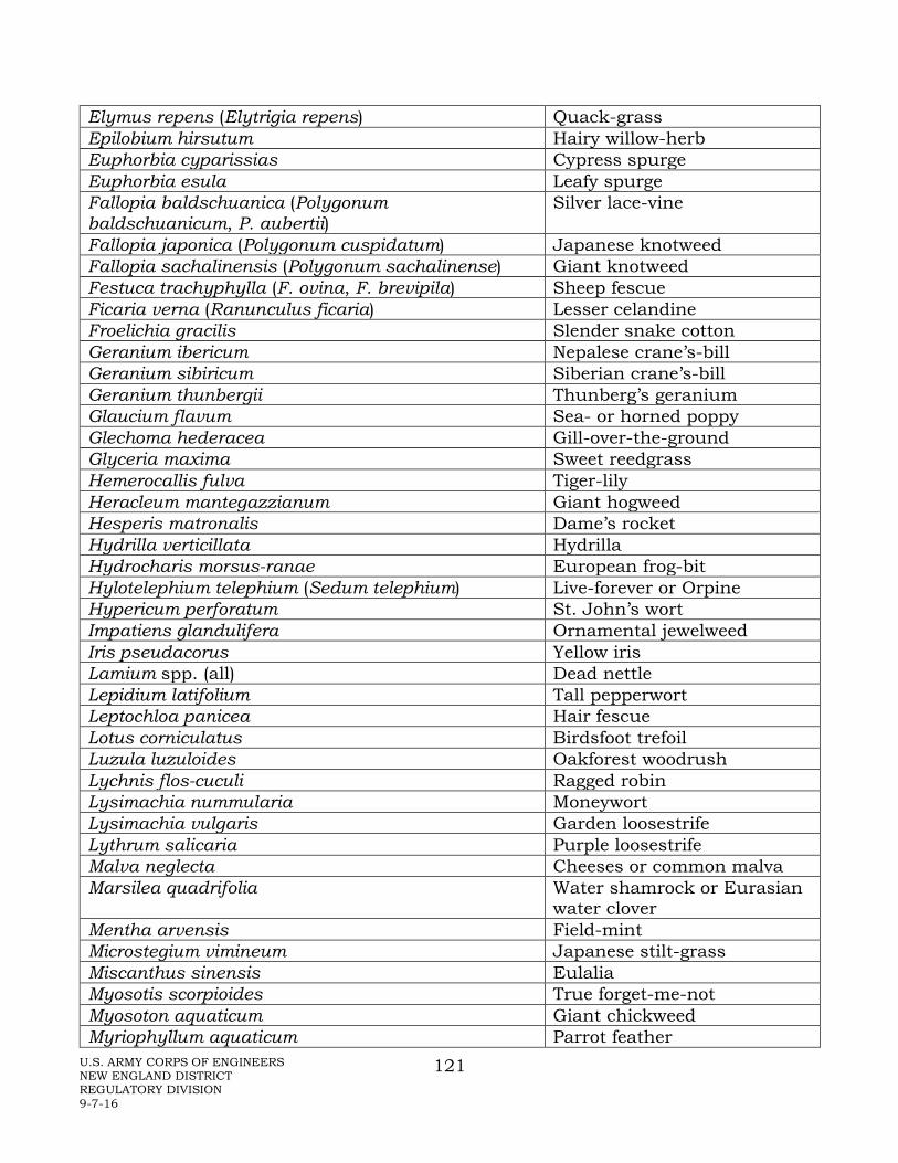
U.S. ARMY CORPS OF ENGINEERS NEW ENGLAND DISTRICT REGULATORY DIVISION 9-7-16
121
Elymus repens (Elytrigia repens) Quack-grass Epilobium hirsutum Hairy willow-herb Euphorbia cyparissias Cypress spurge Euphorbia esula Leafy spurge Fallopia baldschuanica (Polygonum baldschuanicum, P. aubertii)
Silver lace-vine
Fallopia japonica (Polygonum cuspidatum) Japanese knotweed Fallopia sachalinensis (Polygonum sachalinense) Giant knotweed Festuca trachyphylla (F. ovina, F. brevipila) Sheep fescue Ficaria verna (Ranunculus ficaria) Lesser celandine Froelichia gracilis Slender snake cotton Geranium ibericum Nepalese crane’s-bill Geranium sibiricum Siberian crane’s-bill Geranium thunbergii Thunberg’s geranium Glaucium flavum Sea- or horned poppy Glechoma hederacea Gill-over-the-ground Glyceria maxima Sweet reedgrass Hemerocallis fulva Tiger-lily Heracleum mantegazzianum Giant hogweed Hesperis matronalis Dame’s rocket Hydrilla verticillata Hydrilla Hydrocharis morsus-ranae European frog-bit Hylotelephium telephium (Sedum telephium) Live-forever or Orpine Hypericum perforatum St. John’s wort Impatiens glandulifera Ornamental jewelweed Iris pseudacorus Yellow iris Lamium spp. (all) Dead nettle Lepidium latifolium Tall pepperwort Leptochloa panicea Hair fescue Lotus corniculatus Birdsfoot trefoil Luzula luzuloides Oakforest woodrush Lychnis flos-cuculi Ragged robin Lysimachia nummularia Moneywort Lysimachia vulgaris Garden loosestrife Lythrum salicaria Purple loosestrife Malva neglecta Cheeses or common malva Marsilea quadrifolia Water shamrock or Eurasian
water clover Mentha arvensis Field-mint Microstegium vimineum Japanese stilt-grass Miscanthus sinensis Eulalia Myosotis scorpioides True forget-me-not Myosoton aquaticum Giant chickweed Myriophyllum aquaticum Parrot feather

U.S. ARMY CORPS OF ENGINEERS NEW ENGLAND DISTRICT REGULATORY DIVISION 9-7-16
122
Myriophyllum heterophyllum Variable water-milfoil Myriophyllum spicatum Eurasian water-milfoil Najas minor Lesser naiad Nasturtium microphyllum (Rorippa microphylla) One-row yellow cress Nasturtium officionale (Rorippa nasturtium-aquaticum)
Watercress
Nymphoides peltata Yellow floating heart Onopordum acanthium Scotch thistle Ornithogalum umbellatum Star of Bethlehem Pachysandra terminalis Japanese spurge Pastinaca sativa Wild parsnip Persicaria maculosa (Polygonum persicaria) Lady’s thumb Persicaria perfoliata (Polygonum perfoliatum) Mile-a-minute vine Persicaria posumbu (Polygonum caespitosum) Cespitose knotweed Phalaris arundinacea Reed canary-grass Phragmites australis Reed grass, Phragmites Pistia stratiotes Water lettuce Poa compressa Canada bluegrass Poa pratensis Kentucky bluegrass Poa trivialis Rough bluegrass Potamogeton crispus Curly pondweed Puccinellia maritima (P. americana) Seaside alkali-grass Pueraria montana Kudzu Ranunculus repens Creeping buttercup Rorippa amphibia Great yellow cress Rorippa sylvestris Creeping yellow cress Rumex acetosella Sheep-sorrel Rumex obtusifolius Bitter dock Salvinia molesta Salvinia Securigera varia (Coronilla varia) Crown vetch Senecio jacobaea Tansy ragwort Setaria pumila (S. lutescens, S. glauca) Yellow foxtail or yellow
bristlegrass Silphium perfoliatum Cup plant Solanum dulcamara Bittersweet nightshade Stellaria graminea Common stitchwort Tanacetum vulgare Tansy Thymus pulegioides Wild thyme Trapa natans Water-chestnut Tussilago farfara Coltsfoot Typha angustifolia Narrow-leaved cattail Typha latifolia Common or Broad-leaved
cattail Typha x glauca Hybrid cattail
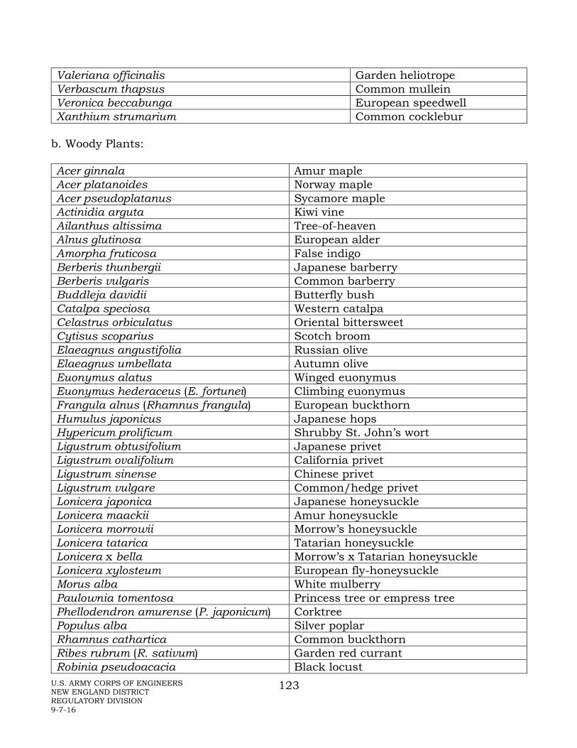
U.S. ARMY CORPS OF ENGINEERS NEW ENGLAND DISTRICT REGULATORY DIVISION 9-7-16
123
Valeriana officinalis Garden heliotrope Verbascum thapsus Common mullein Veronica beccabunga European speedwell Xanthium strumarium Common cocklebur
b. Woody Plants: Acer ginnala Amur maple Acer platanoides Norway maple Acer pseudoplatanus Sycamore maple Actinidia arguta Kiwi vine Ailanthus altissima Tree-of-heaven Alnus glutinosa European alder Amorpha fruticosa False indigo Berberis thunbergii Japanese barberry Berberis vulgaris Common barberry Buddleja davidii Butterfly bush Catalpa speciosa Western catalpa Celastrus orbiculatus Oriental bittersweet Cytisus scoparius Scotch broom Elaeagnus angustifolia Russian olive Elaeagnus umbellata Autumn olive Euonymus alatus Winged euonymus Euonymus hederaceus (E. fortunei) Climbing euonymus Frangula alnus (Rhamnus frangula) European buckthorn Humulus japonicus Japanese hops Hypericum prolificum Shrubby St. John’s wort Ligustrum obtusifolium Japanese privet Ligustrum ovalifolium California privet Ligustrum sinense Chinese privet Ligustrum vulgare Common/hedge privet Lonicera japonica Japanese honeysuckle Lonicera maackii Amur honeysuckle Lonicera morrowii Morrow’s honeysuckle Lonicera tatarica Tatarian honeysuckle Lonicera x bella Morrow’s x Tatarian honeysuckle Lonicera xylosteum European fly-honeysuckle Morus alba White mulberry Paulownia tomentosa Princess tree or empress tree Phellodendron amurense (P. japonicum) Corktree Populus alba Silver poplar Rhamnus cathartica Common buckthorn Ribes rubrum (R. sativum) Garden red currant Robinia pseudoacacia Black locust

U.S. ARMY CORPS OF ENGINEERS NEW ENGLAND DISTRICT REGULATORY DIVISION 9-7-16
124
Rosa multiflora Multiflora rose Rosa rugosa Rugosa rose Rubus phoenicolasius Wineberry Salix purpurea Basket or purple-osier willow Sorbus aucuparia European mountain-ash Taxus cuspidata Japanese yew Ulmus pumila Siberian elm Wisteria floribunda Wisteria

U.S. ARMY CORPS OF ENGINEERS NEW ENGLAND DISTRICT REGULATORY DIVISION 9-7-16
125
APPENDIX L – VERNAL POOL ASSESSMENT
US Army Corps of Engineers – New England District
Vernal Pool Assessment Vernal Pool Definition: Vernal pools are depressional aquatic resource basins that typically go dry in most years and may contain inlets or outlets, typically of intermittent flow. Vernal pools range in both size and depth depending upon landscape position and parent material(s). In most years, vernal pools support one or more of the following obligate indicator species: wood frog, spotted salamander, blue-spotted salamander, marbled salamander, Jefferson’s salamander, Jefferson’s-blue spot polyploid complex, and fairy shrimp. However, they should preclude sustainable populations of predatory fish. Vernal pool areas are comprised of three zones:
• Depression (includes the vernal pool depression up to the spring or fall high water mark, and includes any vegetation growing within the depression), • Envelope (area within 0-100 feet of the vernal pool depression’s edge), and • Critical terrestrial habitat (area within 100-750 feet of the vernal pool depression’s edge).
The envelope and critical terrestrial habitat protect the water quality of the breeding site (e.g., providing shade, leaf litter, and coarse woody material) and support the non-larval life-cycle stages of amphibian species. Note: The Corps may determine that a waterbody should not be designated as a vernal pool based on available evidence. Vernal Pool Assessment: This vernal pool rapid assessment method is designed to characterize vernal pools and to provide a valuation for features of the pool and surrounding habitat for regulatory purposes – impact and compensatory mitigation assessment. Since characteristics of vernal pools vary considerably and in turn can lead to varying functions and levels of functions among different pools, this methodology is designed to offer a simplified approach to assessing and comparing key features of these highly variable aquatic systems. In addition, it can provide a basis for developing appropriate compensatory mitigation for impacts to vernal pools. As each vernal pool or vernal pool complex is unique, the Corps should be consulted prior to developing any specific sampling protocol to ensure that all the necessary data are collected without an over-expenditure of time and resources. Data should be submitted on the Corps of Engineers – New England District “Vernal Pool Characterization Form.”

U.S. ARMY CORPS OF ENGINEERS NEW ENGLAND DISTRICT REGULATORY DIVISION 9-7-16
126
The data collected for assessing vernal pools should be acquired during site visits conducted during the appropriate season(s) (e.g., early spring for egg mass counts, early summer for presence of metamorphs, etc.). When examining for egg masses, the entire pool should be comprehensively surveyed. A minimum of one year’s data is recommended, but two to three years’ data is encouraged to account for variations in reproductive effort, and hydrologic and climatologic conditions. In particular, for large projects that undergo many years of planning, it is highly recommended that vernal pool resources be identified in the initial planning phases to allow for collection of multiple seasons’ worth of site data on any vernal pools present. When abilities to visit and survey the pools are limited to non-optimal times of the year, documentation of the Vernal Pool Characteristics and Vernal Pool Envelope and Critical Habitat Area Characteristics may be useful in determining the presence of vernal pools and their potential level of functioning. Physical characteristics of some pools may be relatively stable, while these same characteristics (e.g., depth, vegetation, substrate, etc.) may vary in others. Such variations in pool characteristics can be accounted for through careful observations and record keeping during site visits. Timing of site visits is crucial to capture the appropriate seasons for sampling. The start of the amphibian breeding season may vary by several weeks from year to year, based on temperature, pool ice cover, and other climatic conditions. In addition to the climatic conditions, the breeding season varies geographically from southern New England to northern New England. To appropriately document faunal usage of pools, repeated visits may be required during different seasons. For instance, some species may require more intensive sampling efforts in comparison to other species when determining presence/absence. Early spring visits are needed to conduct egg mass surveys, while later visits can identify metamorphs and determine reproductive success via the number of metamorphs leaving prior to drying. If deemed appropriate, studies within the vernal pool envelope and critical habitat areas can identify migratory pathways of the pool-breeding amphibians. This can also identify the portions of the surrounding landscape (especially in the vernal pool envelope / critical terrestrial habitat) that are being utilized by particular pool-breeding amphibians. Predators such as fish and bullfrog and green frog larvae have been shown to consume the egg masses and larvae of vernal pool-breeding amphibian species, and have the potential to lessen or cause complete reproductive failure when present in high densities. PLEASE NOTE: The specific combination of indicator and predator species present may have variable impact on the reproductive success of a given indicator species (e.g., the presence of green frog tadpoles may have little or no impact on the reproductive success of spotted salamanders). Therefore, it is important to note the presence/absence and relative abundance of predators. Enough information should be gathered to differentiate sustainable, resident predator populations from smaller, unsustainable or transient groups that will not have as great an impact on vernal pool indicator species. In a pool with high
U.S. ARMY CORPS OF ENGINEERS NEW ENGLAND DISTRICT REGULATORY DIVISION 9-7-16
127
predator densities, it is especially recommended that egg mass counts of vernal pool indicator species be supplemented with larval dip-net sampling or amphibian trapping during the summer and fall months to document larval development and to provide insight on reproductive success. Vernal Pool Characterization Form Instructions: To document how a pool functions within its landscape, a Vernal Pool Characterization Form should be completed for each pool assessed. Additional notes, drawings, and photographs (of the pool and surrounding habitat) are encouraged to supplement this form. Aerial photographs of the pool and surrounding landscape (e.g., from Google Earth©) should also be attached. We recommend doing a complete survey of the project area for vernal pools, as far in advance as possible. The Vernal Pool Characterization Form is divided into three separate sections: vernal pool characteristics, vernal pool envelope and critical terrestrial habitat characteristics, and observed species present. THE VALUATION SCORES ARE TOTALLED SEPARATELY FOR EACH OF THE FIRST TWO SECTIONS. DO NOT COMBINE THESE TWO SCORES INTO A SINGLE SCORE. THE THIRD SECTION DOES NOT RECEIVE A SCORE, ONLY PRESENCE/ABSENCE. The numbers to the right of the checkbox descriptions on this form are the values used to score the features of the vernal pool being evaluated. If there is “NA” or blank space instead of a number next to the checkbox, this feature is used for overall characterization purposes; however, it is not used to value the pool and the box should only be checked if present. For each section, the numbers are totaled for all boxes checked (NA and scoreless boxes are not included) and included at the bottom of the section. Typically, one box per topic will be checked. Under the “Vernal Pool Envelope and Critical Habitat Area Characteristics” (items B.1 and B.2., respectively) multiple items may be checked if the surrounding land use is not homogeneous. In this case, each scored number is related to the percentage of that land use in the vernal pool envelope. For example, if all of the land in the vernal pool envelope is forested, it gets a value of 24. However, if only 50% is forested, this portion gets a 12 (50% of 24) and the remainder gets whatever portion it encompasses (e.g., if the remaining 50% is “open,” it gets a score of 3 and this item gets a total score of 15). It should also be noted under B.1 and B.2 if one or more barriers to migration are present within these zones. These barriers may be natural (e.g., river, lake) or human-made (e.g., large highway), but effectively prevent the vernal pool fauna from crossing to utilize the habitat beyond. If one or more barriers are present, the percentage of the zone that is beyond the barrier(s) should be noted and the remaining percentage of landuse types should be completed for the portion of the zone which is accessible from the pool. Section C documents the presence/absence of species. “Few/common/many” is used for quantifying the non-indicator species present in the pool. Best professional

U.S. ARMY CORPS OF ENGINEERS NEW ENGLAND DISTRICT REGULATORY DIVISION 9-7-16
128
judgment should be used in applying these terms as the actual numbers for each will vary with the type of organisms documented. Checklist for Submissions: Vernal Pool Characterization Form Sketch of pool and surrounding habitat Pool and surrounding habitat photographs Aerial photographs Additional notes, including description of sampling methods

US Army Corps of Engineers - New England District DRAFT Vernal Pool Characterization Form
Project File # Project Name Pool ID Observer Phone or E-mail Landowner/Applicant Phone or E-mail Address City State Zip Location of vernal pool: City/State Survey date(s) Longitude/Latitude (in decimal degrees)
A. VERNAL POOL CHARACTERISTICS (fill in all information known): 1. Landscape setting (check all that apply):
Upland depression (4 pts; if this is also in a floodplain, use 2 pts)
Pool part of a pool complex (within 1000 feet of one or more other vernal pools) (NA)
Pool within larger wetland system (4 pts; if this is also in a floodplain, use 2 pts)
2. Vernal pool condition:
Pool part of wildlife corridor (4 pts)
Other: (variable pts)
Describe any recent modifications to the pool and associated landscape:
3. Parent material:
Glacial fluvial ("outwash")
Dense till
Loose till
Alluvium
Peat
Coastal marine sediments
4. Aquatic resource type that best applies to this pool (choose dominant):
Forested wetland (4 pts) Herbaceous wetland (4 pts) Floodplain (overflow/oxbow) (3 pts)
Shrub wetland (4 pts)
Peatland (acidic fen or bog) (4 pts)
Open water (2 pts) Other: (variable points)
Intermittent stream reach (2 pts)
5. Pool canopy cover (%):
6. Predominant substrate:
Mineral soil
Organic matter (peat/muck) Depth Sampling location (e.g., deepest zone, edge, etc.) 7. Pool size:
a. Approximate dimensions of pool (at maximum capacity; include units): Length
Area:
b. Maximum depth at deepest point at time of survey (include units):
8. Hydrology:
Width
a. Estimated hydroperiod (unless actual, observed hydroperiod value(s) is(are) known, use the presence of these example indicator species to best predict the expected hydroperiod of the pool):
Dries between early March and early July (e.g., Thelypteris palustris, Carex stricta, Impatiens capensis, Ilex verticillata) (6 pts)
Dries between early July and early September (e.g., Sagittaria latifolia, Scirpus cyperinus, Dulichium arund., Cephalanthus occ.) (8 pts)
Dries between early September and early November (e.g., Eleocharis palustris, Glyceria cana., Utricularia spp., Decodon vert.) (8 pts)
Dries between early November and late December, or intermittently exposed (e.g., Nuphar spp., Potamogeton spp.) (2 pts)
b. Inlet/outlet (pick one):
No inlet/outlet (8 pts)
Temporary inlet/outlet (6 pts)
9. Water quality:

Permanent inlet or outlet (channel with well-defined banks and permanent flow) (2 pts)
Clear High turbidity High algae content Tannic
TOTAL for Pool Characteristics (out of 28 max.)
DRAFT
Pool
ID
B. VERNAL POOL ENVELOPE (100 ft) AND CRITICAL HABITAT AREA (100-750 ft) CHARACTERISTICS (fill in all information known):
1. Landuse type and approximate percentage within the 100-ft vernal pool envelope:
Forested % (16 pts)
Shrub % (10 pts)
Open (e.g., meadow, agriculture, golf course) % (4 pts)
Developed % (0 pts)
2. Landuse type and approximate percentage within the 100 - 750-ft vernal pool critical terrestrial habitat:
Forested % (16 pts)
Shrub % (10 pts)
Open (e.g., agriculture, golf course) % (4 pts)
Developed % (0 pts)
Are there one or more barriers to vernal pool fauna movement within the envelope and/or critical terrestrial habitat? If so, check here and see directions for explanation of how to incorporate this information. Based on: Field estimate GIS Aerial photo estimate
TOTAL for Pool Envelope and Critical Terrestrial Habitat Area (out of 32 max.)
C. SPECIES PRESENT IN VERNAL POOL
INDICATOR SPECIES DATE EGG MASSES (#) TADPOLES/LARVAE
Wood Frog (Lithobates sylvaticus)
Spotted Salamander (Ambystoma maculatum)
Blue-spotted Salamander (Ambystoma laterale)
Jefferson's Salamander (Ambystoma jeffersonianum)
Marbled Salamander (Ambystoma opacum)
Fairy Shrimp (Eubranchipus spp.) PRESENT/ABSENT ABUNDANCE:
OTHER SPECIES DATE PRESENCE/ABSENCE FEW/COMMON/MANY
Facultative Species (e.g., Spring Peeper (Pseudacris crucifer), Gray Tree Frog (Hyla versicolor), Caddisflies (Limnephilidae, Phryganeidae), American Toad (Anaxyrus americanus), Eastern Spadefoot Toad (Scaphiopus holbrookii), Fowler's Toad (Anaxyrus fowleri), Fingernail Clams (Sphaeriidae, Pisidiidae))(list):
Rare Species (list):
Predator Species (e.g., Bullfrog/Green frog tadpoles, Fish) (list):
High algae content Tannic

Other species (e.g., Ducks, Turtles, etc.)(list):
Presence of Indicator Species Yes No
SUMMARY:
TOTAL for Pool Characteristics
TOTAL for Pool Envelope and Critical Terrestrial Habitat Area
Other comments (append photographs, additional notes, sketch of pool and surrounding landscape):
9-6-2016

132
U.S. ARMY CORPS OF ENGINEERS NEW ENGLAND DISTRICT REGULATORY DIVISION 9-7-16
APPENDIX M – REFERENCES
Allan, J.D. 1995. Stream Ecology: Structure and function of running waters. Chapman and Hall Press, 388 pp.
Ashby, S. 2002. Approaches for the Mitigation of Water Quality Functions of Impacted Wetlands – A Review. ERDC TN-WRAP-02-03 U.S. Army Research and Development Center, Vicksburg, MS.
Bayley, P.B. 1991. The flood pulse advantage and the restoration of river-floodplain systems. Regulated Rivers: Research and Management 6:75-86.
Bernhardt, E.S. and M.A. Palmer. 2007. Restoring streams in an urbanizing world. Freshwater Biology 52: 738-751.
Bormann, F.H. and G.E. Likens. 1967. Nutrient cycling. Science 155 (3761):424-429.
Brinson, M. M. 1993. A Hydrogeomorphic Classification for Wetlands, Technical Report WRP-DE-4. U.S. Army Engineer Waterways Experiment Station, Vicksburg, MS. NTIS No. AD A270 053.
Burdick, C. and F. Short. 2002. A new seagrass restoration method: TERFS. UNH pamphlet, sponsored by NOAA Restoration Center, University of New Hampshire, Durham.
Calhoun, A.J.K. and P.G. deMaynadier (eds.). 2008. Science and Conservation of Vernal Pools in Northeastern North America. CRC Press, Boca Raton, FL.
Calhoun, A. J. K. and M.W. Klemens. 2002. Best development practices: conserving pool-breeding amphibians in residential and commercial developments in the northeastern United States. MCA Technical Paper No.5, Metropolitan Conservation Alliance, Wildlife Conservation Society, Bronx, NY.
Cowardin, L.M., V. Carter, F.C. Golet, and E.T LaRoe. 1979. Classification of Wetlands and Deepwater Habitats of the United States, Office of Biological Services, FWS/OBS-79/31, December 1979.
Cummins, K.W. 1974. Structure and function of steam ecosystems. Bioscience. 24 (11): 631-641.
Davis, R. C., and F. T. Short. 1997. Restoring eelgrass, Zostera marina L., habitat using a new transplanting technique: The horizontal rhizome method. Aquatic Botany 59:1-15.

133
U.S. ARMY CORPS OF ENGINEERS NEW ENGLAND DISTRICT REGULATORY DIVISION 9-7-16
Environmental Laboratory. 1987. Corps of Engineers Wetlands Delineation Manual, Technical Report Y-87-1, U.S. Army Engineer Waterways Experiment Station, Vicksburg, MS.
Evans, T.E. and A. Leschen. 2010. Technical Guidelines for the Delineation, Restoration, and Monitoring of Eelgrass (Zostera marina) in Massachusetts Coastal Waters. TR-43. Mass. Division of Marine Fisheries, October 2010.
Evans, N.T. and F.T. Short. 2005. Functional trajectory models for assessment of transplant development of seagrass, Zostera marina L., beds in the Great Bay Estuary, NH, USA. Estuaries 28: 936–947.
Executive Order 13112. 1999. Invasive Species.
Federal Aviation Administration Advisory Circular AC No: 150/5200-33B Hazardous Wildlife Attractants on or Near Airports, 8/28/2007
Fonseca, M. S., W. J. Kenworthy and G. W. Thayer. 1998. Guidelines for the conservation and restoration of seagrasses in the U. S. and adjacent waters. NOAA Coastal Ocean Program. Decision Analysis Series No. 12.
Galat, D.L., L.H. Fredricksen, D.D. Humberg, K.J. Bataille, J.R. Bodie, J. Dohrenwend, G.T. Gelwicks, J.E. Havel, D.L. Helmers, J.B. Hooker, J.R. Jones, M.F. Knowlton, J. Kubisiak, J. Mazourek, A.C. McColpin, R.B. Renken, and R.D. Semlitsch. 1998. Flooding to restore connectivity of regulated, large-river wetlands. Bioscience. 48( 9): 721-733.
Gergel, S.E., M.E. Turner, J..R Miller, J.M. Melack, and E.H. Stanley. 2002. Landscape indicators of human impacts to riverine systems. Aquatic Sciences 64: 118-128.
Gomi, T., R.C. Sidle, and J.S. Richardson. 2002. Understanding processes and downstream linkages of headwater systems. Bioscience 52 (10): 905-916.
Gordon, N.D., T.A. McMahon, B.L. Finlayson, C.J. Gippel, and R.J. Nathan. 2004. Stream Hydrology for Ecologists. John Wiley and Sons, 429 pp.
Grant, E.H.C., Jung, R.E., Nichols, J.D., and Hines, J.E. 2005. Double-observer approach to estimating egg mass abundance of pool-breeding amphibians: Wetlands Ecology and Management, v. 13, p. 305–320.
Hughes, R.M., L. Wang, and P.W. Seelhach, (eds.). 2006. Landscape Influences on Stream Habitats and Biological Assemblages. American Fisheries Society Symposium 48.

134
U.S. ARMY CORPS OF ENGINEERS NEW ENGLAND DISTRICT REGULATORY DIVISION 9-7-16
Hynes, H.B.N. 1975. The stream and its valley. Ver Handlungen des Internationalen Verein Limnologie 19: 1-15.
Leopold, L. 1994. A View of the River. Harvard University Press, Cambridge, MA, 298 pp.
Leopold, L., M.G. Wolman, and J.P. Miller. 1992. Fluvial Processes in Geomorphology. Dover Publications, 521 pp.
Leschen, A.S., R.K. Kessler, and B.T. Estrella. 2009. Eelgrass Restoration Project: 5 Year Completion Report. Massachusetts Division of Marine Fisheries. Accessed 7/29/09.
Lockwood, J.C. 1991. Seagrass Survey Guidelines for New Jersey; Prepared for the New Jersey Interagency Seagrass Policy Committee. National Marine Fisheries Service, Habitat and Protected Species Division, Sandy Hook Laboratory, New Jersey.
Mehrhoff, L.J., J.A. Silander, Jr., S. A. Leicht and E. Mosher. 2003. IPANE: Invasive Plant Atlas of New England. Department of Ecology and Evolutionary Biology, University of Connecticut, Storrs, CT, USA.
Minkin, P. and R. Ladd. 2003. Success of Corps-Required Wetland Mitigation in New England. New England District Corps of Engineers, Concord, MA.
Montgomery, D.R. and J.M. Buffington. 1998. Channel Process, Classification, and Response. Pages 13-42 In R. Naiman and R Bilby, Editors, River Ecology and Management Lessons from the Pacific Coastal Ecoregion, 705 pp.
Naiman, R.J., Decamps H., and McClain M.E. (eds.). 2005. Riparia: Ecology, Conservation, and Management of Streamside Communities, Elsevier Academy Press, 430 pp.
Naiman, R.J. and R.E. Bilby (eds.). 1998. River Ecology and Management: Lessons from the Pacific Coastal Ecoregion. Springer-Verlag, 705 pp.
National Research Council. 2001. Compensating for Wetland Losses under the Clean Water Act. National Academy Press. Washington, DC. 322 pp.
National Research Council. 2002. Riparian Areas: Functions and Strategies for Management. National Academy Press. Washington, DC. 428 pp.
Natural Resources Conservation Service. 2009. Stream Visual Assessment Protocol Version 2. National Biology Handbook, Subpart B – Conservation Planning, Part 614. 190-VI-NBH.

135
U.S. ARMY CORPS OF ENGINEERS NEW ENGLAND DISTRICT REGULATORY DIVISION 9-7-16
Noble, C. V. 2006. Water table monitoring project design. WRAP Technical Notes Collection (ERDC TN-WRAP-06-2), U.S. Army Engineer Research and Development Center, Vicksburg, MS. http://el.erdc.usace.army.mil/wrap/
North American Amphibian Monitoring Program (NAAMP). 2002.
North American Amphibian Monitoring Program (NAAMP), Massachusetts Procedures and Protocols. 2007.
Palmer, E.S., Bernhardt, J.D. Allan, R.S. Lake, G. Alexander, S. Brooks, J. Carr, S. Clayton, C.N. Dahm, J. Follstad Shah, D.L. Galat, S.G. Loss, P. Goodwin, D.D. Hart, B. Hassett, R. Jenkinson, G.M. Kondolf, R. Lave, J.L. Meyer, T.K. O’Donnell, L. Paganp, and E. Sudduth. 2005. Standards for ecologically successful river restoration. Journal of Applied Ecology 42:208-217.
Paton, P. W. C., Timm B., and T. Tupper. 2003. Monitoring Pond-Breeding Amphibians: A Protocol for the Long-term Coastal Ecosystem Monitoring Program at Cape Cod National Seashore.
Paul, M.J. and J. Meyer. 2001. Streams in the urban landscape. Annual Review of Ecological Systems 32:333-365.
Rabenhorst, M.C. 2008. Protocol for using and interpreting IRIS tubes. Soil Survey Horizons 49: 74-77.
Rheinhardt, R. and G. Hollands. 2008. Classification of vernal pools: geomorphic setting and distribution. pp 11-30 in Calhoun, A.J.K. and P.G. deMaynadier (eds.), Science and Conservation of Vernal Pools in Northeastern North America. CRC Press, Boca Raton, FL.
Roni, P., T.J. Beechie, R.F. Bilby, F.E. Leonatti, M.M. Pollock, and G.R. Pess. 2002. A review of stream restoration techniques and a hierarchical strategy for prioritizing restoration in Pacific Northwest Watershed. North American Journal of Fisheries Management 22: 1-20.
Sabol, B., D. Shafer, and E. Lord. 2005. Dredging effects on eelgrass (Zostera marina) distribution in a New England small boat harbour. U. S. Army Corps of Engineers. Engineer Research and Development Center ERDC/EL TR-05-8.
Short, F. T., D. M. Burdick, C. A. Short, R. C. Davis, and P. A. Morgan. 2000. Developing success criteria for restored eelgrass, salt marsh and mud flat habitats. Ecological Engineering 15:239–252.

136
U.S. ARMY CORPS OF ENGINEERS NEW ENGLAND DISTRICT REGULATORY DIVISION 9-7-16
Short, F. T., L. J. McKenzie, R. G. Coles, K. P. Vidler, and J. L. Gaeckle. 2006. SeagrassNet Manual for Scientific Monitoring of Seagrass Habitat. Worldwide edition. Durham, New Hampshire: University of New Hampshire. 75. p.
Short, F.T., A. Klein, and G. Moore. 2012. The eelgrass resources of southern New England and New York: science in support of management and restoration success (phase I).
Short, R. C., B. C. Kopp, C. A. Short and D. M. Burdick. 2002. Site selection model for optimal restoration of eelgrass (Zostera marina L). Marine ecology Progress Series 227:253-267.
Smith, D., A. Ammann, C. Bartoldus, and M. Brinson. 1995. An approach for assessing wetland functions using hydrogeomorphic classification, reference wetlands, and functional indices. Technical Report WRP-DE-9. U.S. Army Engineer Waterways Experiment Station, Vicksburg, MS.
Soil Survey Staff. 2014. Keys to Soil Taxonomy, 12th ed. USDA-Natural Resources Conservation Service, Washington, DC.
Sprecher, S. W. 2000. Installing Monitoring Wells/Piezometers in Wetlands, ERDC TN-WRAP-00-02. U.S. Army Research and Development Center, Vicksburg, MS.
Stanford, J.A., J.V. Ward, W.J. Liss, C.A. Frissell, and R.N. Williams. 1996. A general protocol for restoration of regulated rivers. Regulated rivers: Research and Management, 12: 391-413.
Stanford, J.A. and J.V. Ward. 1993. An ecosystem perspective of alluvial rivers: connectivity and the hyporheic corridor. Journal of North American Benthological Society. 12(1):48-60.
Stephan, C. D. and T. E. Bigford. 1977. Atlantic Coastal Submerged Aquatic Vegetation. Atlantic States Marine Fisheries Commission, ASMFC Habitat Management Series No. 1.
Strahler, A.N. 1957. Quantitative analysis of watershed geomorphology. Trans. Amer. Geophysical Union 38:6, pp. 913-920.
Streever, W., and Perkins, E. 2000. Importing plant stock for wetland restoration and creation: Maintaining genetic diversity and integrity. WRAP Technical Notes Collection (ERDC TN-WRAP-00-03), U.S. Army Engineer Research and Development Center, Vicksburg, MS.

137
U.S. ARMY CORPS OF ENGINEERS NEW ENGLAND DISTRICT REGULATORY DIVISION 9-7-16
Tiner, R.W. 2014. Dichotomous Keys and Mapping Codes for Wetland Landscape Position, Landform, Water Flow Path, and Waterbody Type Descriptors: Version 3.0. U.S. Fish and Wildlife Service, National Wetlands Inventory Program, Northeast Region, Hadley, MA. 65 pp. plus Appendices.
Treasury Department Circular 570. U.S. Department of Treasury, Financial Management Service, Surety Bond Branch, 401 14th Street, NW, 2nd Floor, West Wing, Washington, DC 20227.
U.S. Army Corps of Engineers, New England District. 1999. The Highway Methodology Workbook Supplement: wetland functions and values, a descriptive approach.
U.S. Army Corps of Engineers. 2002. Guidance on Compensatory Mitigation Projects for Aquatic Resource Impacts Under the Corps Regulatory Program Pursuant to Section 404 of the Clean Water Act and Section 10 of the Rivers and Harbors Act of 1899. Regulatory Guidance Letter 02-02.
U.S. Army Corps of Engineers, Norfolk District. 2004. Corps and Virginia Department of Environmental Quality Recommendations for Wetland Compensatory Mitigation: Including Site Design, Permit Conditions, Performance and Monitoring Criteria.
U.S. Army Corps of Engineers. 2005. Technical Standard for Water-Table Monitoring of Potential Wetland Sites. WRAP Technical Notes Collection (ERDC TN-WRAP-05-2), U.S. Army Engineer Research and Development Center, Vicksburg, MS.
U.S. Army Corps of Engineers. 2008. 33 CFR Part 332, Compensatory Mitigation for Losses of Aquatic Resources, Final Rule, dated April 10, 2008 (“Mitigation Rule”)
U.S. Army Corps of Engineers. 2008. Minimum Monitoring Requirements for Compensatory Mitigation Projects Involving the Restoration, Establishment, and/or Enhancement of Aquatic Resources. Regulatory Guidance Letter 08-03.
U.S. Army Corps of Engineers. 2012. Regional Supplement to the Corps of Engineers Wetland Delineation Manual: Northcentral and Northeast Region, ed. J.S. Wakeley, R.W. Lichvar, and C.V. Noble. ERDC/EL TR-12-1. Vicksburg, MS: U.S. Army Engineers Research and Development Center.
U.S. Army Corps of Engineers. 2013. Incorporating Sea Level Change in Civil Works Programs. EC 1100-2-8162.
138
U.S. ARMY CORPS OF ENGINEERS NEW ENGLAND DISTRICT REGULATORY DIVISION 9-7-16
U.S. Department of Interior, Bureau of Reclamation. 2009. Inspection and Cleaning Manual for Equipment and Vehicles to Prevent the Spread of Invasive Species. Technical Memorandum No. 86-68220-07-05.
U.S. Environmental Protection Agency. 2002. Methods for Evaluating Wetland Condition: Using Amphibians in Bioassessments of Wetlands. Office of Water, U.S. Environmental Protection Agency, Washington, DC. EPA-822-R-02-022.
Vannote, R.L., G.W. Marshall, K.W. Cummins, J.R. Sedell, and C.E. Cushing. 1980. The river continuum concept. Canadian Journal of Fisheries and Aquatic Sciences 37:130-137.
Vermont Agency of Natural Resources. November, 2008. River Corridor Protection Guide. 25 pp.
Verry, E.S., Hornbeck J.W., and C.A. Dolloff (eds.). 2000. Riparian Management in Forests of the Continental Eastern United States. Lewis Publishers, 402 pp.
Ward, J.V. 1989. The four-dimensional nature of lotic ecosystems. Journal of the North American Benthological Society 8(1):2-8.
Williams, B.K., R.C. Szaro, and C.D. Shapiro. 2009. Adaptive Management: The US Department of Interior Technical Guide. Adaptive Management Working Group, US Department of the Interior, Washington, DC.
Williams J.E., C. Wood, and M. Dombeck (eds.). 1997. Watershed Restoration: Principles and Practices. American Fisheries Society, 561 pp.
Williams, S. 2007. Introduced species in seagrass ecosystems: status and concerns. Journal of Experimental Marine Biology and Ecology. 350: 89-110.
Woods Hole Group. 2014. Southern New England and New York seagrass research towards restoration.